Article

Assessment of Asphalt Pavement Skid Resistance Using Ground-Based and UAV-Based Hyperspectral Synergy


1
School of Aeronautic Engineering, Changsha University of Science and Technology, Changsha 410114, China
2
School of Public Affairs, Zhejiang University, Hangzhou 310058, China
*
Author to whom correspondence should be addressed.
Drones 2026, 10(3), 209; https://doi.org/10.3390/drones10030209
Submission received: 30 December 2025 / Revised: 6 March 2026 / Accepted: 13 March 2026 / Published: 17 March 2026

Highlights

What is the main finding?
  • A rapid, contactless, and large-scale method for assessing asphalt pavement skid resistance was developed based on UAV-borne hyperspectral remote sensing.
What are the implications of the main finding?
  • A quantitative relationship between the aging spectral index and skid resistance was established, enabling reliable skid resistance prediction.
  • The proposed approach extends the application of UAV hyperspectral remote sensing in pavement maintenance and road safety management.

Abstract

Accurate assessment of the skid resistance of asphalt pavement is crucial for traffic safety. However, traditional detection methods suffer from inefficiency, high costs, and limited coverage, making them inadequate for large-scale road network monitoring. This paper proposes a method for assessing the skid resistance of asphalt pavements based on hyperspectral remote sensing. First, hyperspectral data of asphalt pavements with different aging degrees were acquired through ground-based spectral measurements, and feature bands correlated with the aging process were selected using the successive projections algorithm. Based on these results, the feature bands were applied to unmanned aerial vehicle (UAV)-based hyperspectral images to construct an aging spectral index capable of characterizing pavement aging conditions. Combined with the decision tree method, assessment of pavement aging conditions was achieved, with an overall accuracy of 96.52% and a Kappa coefficient of 0.948. Finally, a quantitative relationship model between the aging spectral index and skid resistance was established using regression analysis, with the coefficient of determination (R2) and root mean square error (RMSE) of the model being 0.869 and 3.26, respectively. The proposed method enables efficient, contactless and large-scale assessment of pavement skid resistance, expanding the application of UAV remote sensing technology in road maintenance.

1. Introduction

Asphalt pavements, as an essential component of modern transportation infrastructure, play a key role in promoting regional economic development and social progress [1,2]. However, with the increase in service life, the material properties of asphalt pavements inevitably deteriorate under the coupled effects of persistent traffic loads, temperature–humidity cycles, ultraviolet radiation, and water-induced erosion. This aging process is primarily manifested in the attenuation of surface micro-texture and the degradation of macro-structural features, directly leading to a decline in skid resistance and significantly increasing the risk of vehicle skidding, thereby posing a serious threat to road traffic safety [3,4,5]. Current skid resistance detection methods suffer from inefficiency, high costs, and limited spatial coverage, making it challenging to achieve efficient and large-scale routine inspections, particularly in remote or low-accessibility areas [6,7]. Therefore, there is an urgent need to develop a novel approach for asphalt pavement skid resistance detection that is efficient, contactless, and capable of large-scale application.
Currently prevalent skid resistance assessment methods mainly rely on manual on-site surveys or vehicle-mounted equipment measurements. These conventional approaches not only suffer from low detection efficiency and limited coverage, but also cause traffic interference problems due to their contact detection, resulting in disproportionate allocation of maintenance resources to major arterial roads while leaving vast networks of low-grade and remote roads without timely performance monitoring or adequate maintenance interventions [8,9,10,11]. Remote sensing technology, with its advantages of rapid data acquisition, high efficiency, and superior spectral resolution, provides a novel technical solution for non-contact and large-scale roadway skid resistance detection [12,13,14].
Unmanned aerial vehicle (UAV) hyperspectral remote sensing technology offers the advantages of high resolution, non-contact operation, high efficiency, and strong operational flexibility, providing a more promising approach for pavement skid resistance assessment. By capturing detailed spectral features of road surfaces in the visible-near-infrared wavelength bands, it can sensitively identify asphalt component changes and surface texture degradation caused by aging [15,16,17,18]. Researchers have explored the application of UAV hyperspectral technology for assessing asphalt pavement aging conditions. For instance, Mohammadi (2012) used UAV HyMap data to assess pavement aging by calculating mean spectral reflectance values, but 40% of pixels were misclassified [15]. Herold et al. (2008) performed aging condition identification on UAV HyperSpecTIR imagery based on pavement spectral characteristics analysis, but their method is applicable only to high-quality asphalt pavements, and the selection of feature bands lacks justification [16]. While these studies demonstrate the feasibility of UAV hyperspectral technology for monitoring pavement aging, their assessment accuracy remains inadequate. Beyond the characterization of aging conditions, in recent years (2022–2025), the application of UAV hyperspectral technology in road scenarios has been continuously expanding, and related studies have gradually shifted from single-state identification toward richer pavement information sensing and engineering-oriented expression. In the field of pavement distress identification and detailed mapping, researchers have introduced joint features and deep learning methods to achieve automatic recognition and hierarchical characterization of typical distresses such as cracks and potholes [19,20,21]. For example, Chen et al. (2024) constructed spectral–texture joint features based on UAV hyperspectral imagery to realize fine-scale mapping of multiple types of pavement distresses [19]; Pietersen et al. (2024) proposed an autonomous reflectance calibration method for near-ground UAV hyperspectral data oriented toward runway damage assessment, providing a reliable basis for the automatic identification of distresses and anomalous areas [21]. In terms of road construction–stage monitoring and quality control, UAV hyperspectral data have also been used to rapidly perform areal mapping of key state variables at construction sites, thereby providing data support for construction organization optimization and quality acceptance [22,23,24]. For instance, Lee et al. (2022) proposed a spectral index and color-coded map (CCM)–based representation framework for water content under road construction scenarios [22]; subsequently, Lee et al. (2024) further constructed a subgrade soil water content prediction model based on UAV hyperspectral imagery at actual construction sites, significantly improving the operability and applicability of such methods in engineering scenarios [24]. Overall, these studies have significantly expanded the application boundaries of UAV hyperspectral technology in pavement structural state perception and performance evaluation.
However, existing studies still largely remain at the levels of “aging mapping”, “distress identification”, and “construction-stage monitoring”, with limited exploration of hyperspectral technology for skid resistance evaluation. Mechanistically, material aging affects both the surface texture and material structure of the pavement, which not only alters its surface reflectance characteristics but also directly leads to a reduction in skid resistance [25]. Although Carmon et al. (2018) achieved preliminary prediction of asphalt pavement dynamic friction coefficients by analyzing correlations between imaging spectral data and dynamic friction values using the ‘PARACUDA’ system, existing studies have yet to establish a clear link between spectral features, aging degree, and skid resistance [26]. This gap restricts the direct application of hyperspectral technology for pavement skid resistance detection.
This study proposes a ground-based UAV hyperspectral synergy framework for large-scale assessment of asphalt pavement skid resistance by establishing a direct linkage between spectral aging characteristics and in situ friction measurements. The proposed approach transcends traditional contact-based inspection paradigms and demonstrates how surface optical responses can be exploited to infer safety-related functional properties of infrastructure. It provides a scalable, noninvasive pathway for network-level pavement performance monitoring and contributes to the advancement of intelligent, data-driven infrastructure management.

2. Data Collection and Preprocessing

2.1. Study Area

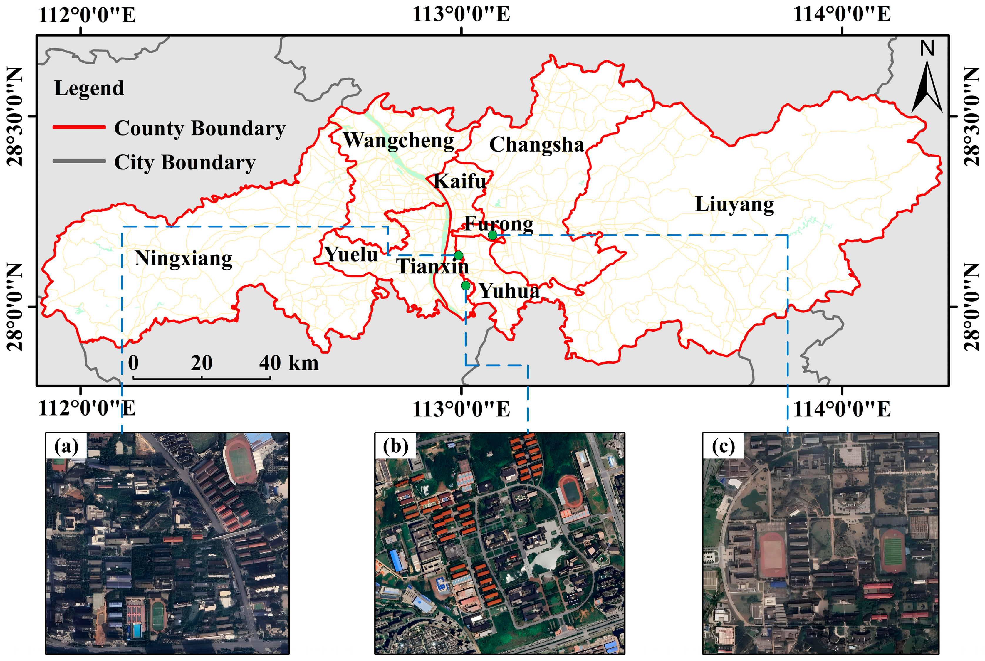
This study selected typical asphalt roads in the urban area of Changsha City, Hunan Province, China as study areas (Figure 1). Based on the traffic volume classification standard in China’s Specifications for Design of Highway Asphalt Pavement, the study area represents typical unban primary and secondary roads with medium to light traffic levels [27]. In accordance with the technical requirements of the China’s Code for Pavement Design of Urban Road, all selected roads adopt AC-F/C graded layer structure, using ordinary road petroleum bitumen as the binding material and local limestone and granite as the main aggregate sources [28]. To ensure the representativeness and reliability of experimental data, this study identified three typical areas with smooth surfaces and minimal distress through field surveys as research zones. All data collection was completed between September and November 2024.

2.2. Ground-Based Spectral Measurements

This study employed a FieldSpec 4 ground-based non-imaging hyperspectral spectrometer (ASD Inc., Longmont, CO, USA) for pavement hyperspectral data collection, with the following technical parameters: spectral range covering the full spectrum from 350–2500 nm using a three-detector optical system, where the visible-near-infrared region (VNIR, 350–1000 nm) has a spectral sampling interval of 1.4 nm and the short-wave infrared regions (SWIR1: 1001–1800 nm; SWIR2: 1801–2500 nm) feature a spectral sampling interval of 1.1 nm. The instrument demonstrates superior performance with an average signal-to-noise ratio (SNR) exceeding 1400 in the 400–900 nm range and surpassing 1500 in the 1100–2500 nm range, meeting the requirements for high-precision spectral measurements.
The data collection was carried out from 10:00 to 14:00 (Beijing time) between September and November 2024 under clear, cloud-free weather conditions with wind speeds below level 5. During measurements, the fiber optic probe was positioned vertically at a height of 0.32 m above the pavement surface, with a 25° field of view corresponding to a circular measurement area approximately 14 cm in diameter. The study selected 70 representative pavement sample points with varying degrees of aging, with each point measured once to record five spectral data readings, yielding a total of 350 raw spectral reflectance curves. The average of these five spectral reflectance curves was calculated as the final hyperspectral reflectance data for each sample point, while auxiliary information including digital images and Munsell Neutral Value Scale Card (MNVSC) chromaticity values were simultaneously recorded for each sampling location.

2.3. UAV Hyperspectral Data Measurements

This study employed the X20P frame-based hyperspectral imaging system developed by Cubert GmbH (Ulm, Germany) for UAV hyperspectral data acquisition. The equipment was mounted on a DJI M350 RTK multirotor UAV platform (SZ DJI Technology Co., Ltd., Shenzhen, China) and exhibits the following technical characteristics: spectral range covering 350–1002 nm with the capability to simultaneously acquire data from over 160 continuous spectral channels; utilizing unique frame-based imaging technology to achieve high-speed, high-resolution data collection. Given the linear characteristics of roads, a strip flight path planning strategy was implemented with 70% side overlap and 80% forward overlap, maintaining a flight altitude of 100 m above ground level corresponding to a ground sampling distance of 13 cm × 13 cm. After pan-sharpening processing, the spatial resolution of hyperspectral imagery could be enhanced to 3 cm.
The preprocessing of UAV hyperspectral data mainly includes raw data conversion, radiometric correction, pan-sharpening, data mosaicking, and geometric precision correction. Data conversion, radiometric correction and pan-sharpening were completed using the X20P hyperspectral sensor’s dedicated data processing software, Cubert Utils Touch V2.9.1. Data mosaicking was carried out in Agisoft Metashape Professional 2.0.2 software, and the spliced orthorectified images in TIFF format were finally exported, and the geometric precision correction was realized by ENVI 5.6 software. The vector data of the roads in the study area were extracted by visual interpretation and cropped to obtain UAV hyperspectral images of the roads in the study area.
Based on the preprocessing results, 14,455 sample pixels covering pavement surfaces with varying degrees of aging were acquired through sampling. A stratified random sampling method was used to divide the sample set into a training set (9974 pixels) and a validation set (4481 pixels) at a 7:3 ratio.

2.4. Measurement of Pavement Skid Resistance

In this study, the British Pendulum Tester (BPT) was used to measure the British Pendulum Number (BPN) at each sample point, which served as the evaluation metric for pavement skid resistance. All measurements were conducted in strict accordance with the technical specifications outlined in the Field Test Methods of Highway Subgrade and Pavement in China, with special attention given to three key parameters: maintaining a water film thickness of 0.5 mm, applying real-time corrections for ambient temperature, and ensuring scientifically distributed measurement points [29]. The data collection was conducted between October and November 2024, with multiple repeated measurements performed at each sample point. The average of five stable measurement results was ultimately used as the pendulum value determination data for each sample point.
Following the completion of pavement skid resistance data collection, data preprocessing was conducted by first eliminating abnormal sample points located in shadowed areas or obstructed by vehicles. After screening, a total of 196 valid sample points were retained, which were allocated using the concentration gradient method, with 131 sample points assigned to the modeling set and the remaining 65 sample points designated for the validation set.

3. Methods

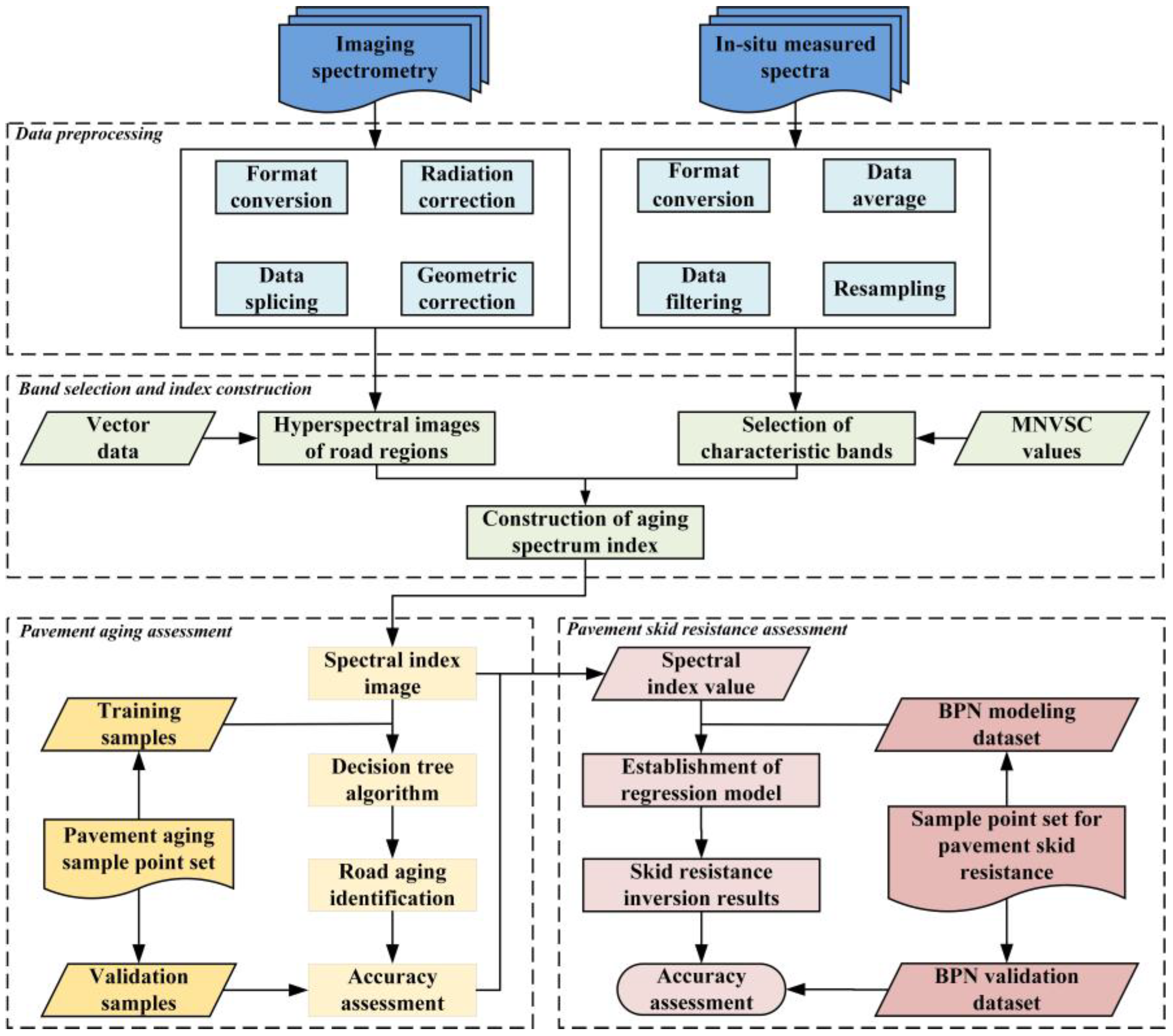
This study proposes a UAV-based hyperspectral remote sensing method for assessing the skid resistance of asphalt pavement. First, ground-based non-imaging hyperspectral data were used to analyze the spectral characteristics of pavements at different aging degrees, and feature bands highly correlated with aging were identified. Second, based on UAV hyperspectral imagery, an aging spectral index was developed to represent pavement aging conditions, and a decision tree algorithm was applied for classification and mapping of aging stages. Finally, a quantitative relationship between the aging spectral index and skid resistance was established using a nonlinear regression approach. The overall workflow is illustrated in Figure 2.

3.1. Quantitative Description for Asphalt Pavement Aging

Previous studies and field investigations have demonstrated that pavement aging significantly alters optical properties, specifically reflected by increased reflectance in the visible–near-infrared (VNIR) spectrum and changes in surface brightness values [30,31,32,33]. This study employs the Munsell Neutral Value Scale Card (MNVSC) to establish a standardized quantification system for aging classification, which divides the continuous black-white grayscale spectrum into 37 standard levels according to the ISCC-NBS international standard [34]. Through field measurements and expert interpretation, asphalt pavement aging conditions were classified into three stages: slightly aged (SA) [N1.75/–N4.25/], moderately aged (MA) [N4.5/–N6.75/), and heavily aged (HA) [N6.75/–N8.75/] (Table 1). This classification method, based on an internationally recognized colorimetric standard, ensures the objectivity and reproducibility of the evaluation results and provides a reliable reference for the subsequent correlation analysis between spectral characteristics and aging degrees.

3.2. Construction of Aging Spectral Index

This study employed the Successive Projections Algorithm (SPA) to analyze ground-based hyperspectral reflectance data with different aging degrees, selecting feature bands highly correlated with aging levels to provide a foundation for subsequent spectral index construction. Developed by Araujo and Soares et al., the SPA algorithm is a forward iterative variable selection method whose core advantage lies in effectively addressing multicollinearity issues in high-dimensional spectral data while identifying feature bands with high information content and low redundancy [35,36]. In implementation, ground-based hyperspectral reflectance data (350–1002 nm) served as independent variables and MNVSC values as dependent variables for feature band selection. Considering potential output variations due to SPA’s random initialization, five independent runs were performed, with bands consistently appearing in three or more results selected as feature bands.
To ensure the feature bands selected from ground-based non-imaging hyperspectral data can be effectively applied to UAV hyperspectral imagery, this study conducted consistency processing in spectral, spatial, and temporal dimensions: (1) Spectral range matching: ground-based hyperspectral data were resampled to the UAV’s 164 spectral bands (350–1002 nm) through convolution operations to achieve unified spectral resolution and band structure. (2) Spatial scale unification: the ground spectral measurement area (14 cm diameter) maintained spatial consistency with the UAV’s original resolution (13 cm). (3) Synchronous temporal measurement: ground-based non-imaging spectral measurements were conducted simultaneously with UAV hyperspectral image acquisition to ensure observational condition consistency.
The feature bands selected from ground-based hyperspectral data were applied to UAV hyperspectral imagery to construct a geometry-based aging spectral index for characterizing asphalt pavement aging degree. This index was designed based on the following principle: as asphalt pavement aging intensifies, the morphological characteristics of its spectral reflectance curve within the feature band range undergo changes, primarily manifested as significant expansion of reflectance differences. By calculating the geometric area enclosed by spectral reflectance curves between feature bands, this changing process can be effectively quantified. The specific mathematical expression of this index and its physical significance will be elaborated in Section 4.2.

3.3. Pavement Aging Conditions Assessment Based on UAV Hyperspectral Imagery

The constructed aging spectral index was applied to UAV hyperspectral imagery to calculate spectral index values for each pixel, enabling pavement aging condition assessment through decision tree algorithms. The Decision Tree algorithm represents a classical machine learning approach characterized by simple structure, ease of interpretation, low computational complexity, and high classification accuracy [37]. Its core principle involves partitioning data based on specific feature conditions to maximize internal sample homogeneity within subsets, commonly employed for solving classification and regression problems. This study adopted the Classification and Regression Tree (CART) algorithm to achieve asphalt pavement aging condition assessment.
To validate the accuracy of the assessment results, this study employed a confusion matrix for evaluation. The confusion matrix quantitatively characterizes classification model performance by constructing a two-dimensional cross-tabulation of actual versus predicted categories, where diagonal elements represent correctly classified samples and off-diagonal elements indicate error distribution. Based on this matrix, five key metrics were calculated: Producer’s Accuracy (PA) measuring classification completeness per category, User’s Accuracy (UA) evaluating result reliability, Overall Accuracy (OA) reflecting global classification performance, Kappa coefficient quantifying agreement beyond chance, and Macro-F1 score comprehensively considering precision and recall [38]. The specific calculation formulas for each metric are as follows:
P A = x i i x + i
U A = x i i x i +
O A = i = 1 n x i i N
K a p p a = N i = 1 n x i i i = 1 n ( x i + x + i ) N 2 i = 1 n ( x i + x + i )
Macro - F 1 = 2 × ( Macro - Precision ) × ( Macro - Recall ) ( Macro - Precision ) + ( Macro - Recall )
where N denotes the total number of samples participating in the evaluation, n is the number of rows and columns in the confusion matrix, x i i is the number of samples in row i and column i in the confusion matrix, and x i + and x + i are the total number of samples in row i and column i, respectively. Macro-F1, Macro-Precision, and Macro-Recall are calculated as the arithmetic means of the F1 scores, precision, and recall across all categories. The larger the value of each index, the better the classification precision.

3.4. Asphalt Pavement Skid Resistance Assessment Model

This study employed bivariate nonlinear least squares regression to establish a quantitative relationship model between the aging spectral index and skid resistance. The method optimizes parameter fitting for predefined nonlinear function models through optimization algorithms to minimize the sum of squared residuals between predicted and measured values, thereby obtaining optimal fitting relationships [39,40]. Model performance was evaluated through significance and prediction accuracy analyses: (1) F-tests and t-tests assessed overall regression equation significance and parameter significance; (2) systematic evaluation of model goodness-of-fit and prediction accuracy utilized metrics including coefficient of determination (R2), mean absolute percentage error (MAPE), root mean square error (RMSE), and Akaike Information Criterion (AIC).

4. Results

4.1. Spectral Analysis of Aged Asphalt Pavements

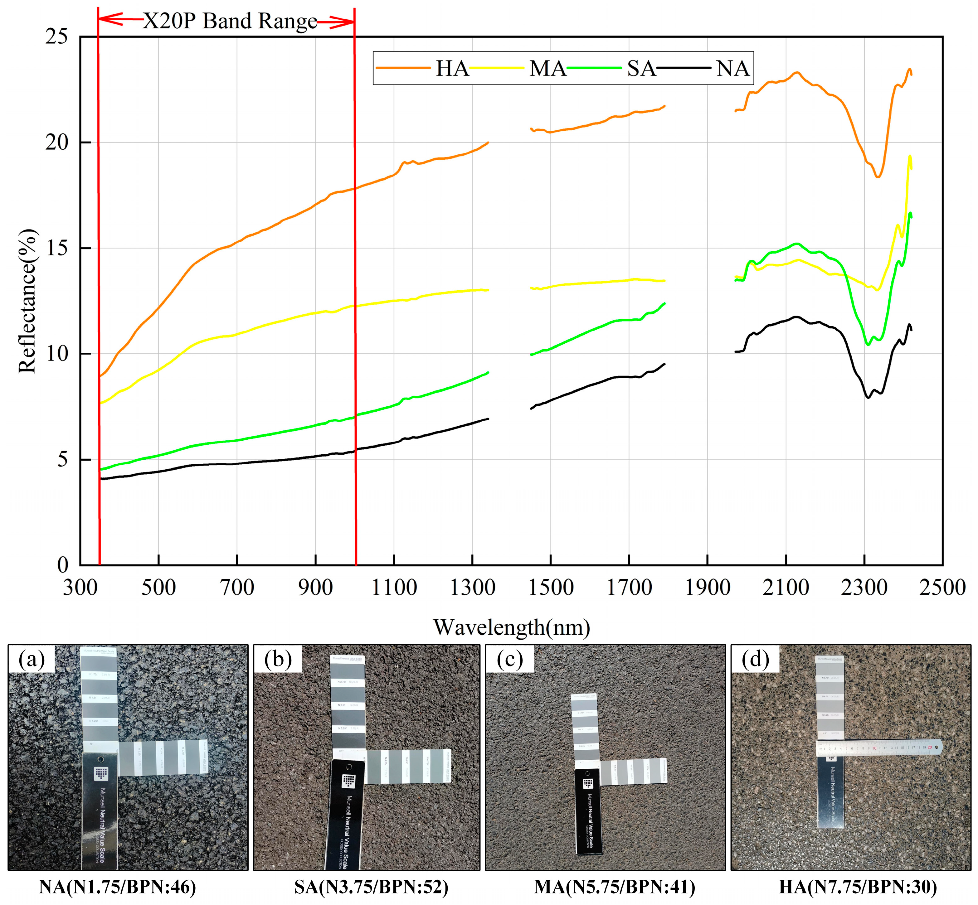
Based on the aging classification criteria established in Section 3.1, this study analyzed the spectral reflectance variations across different aging stages (Figure 3). Analysis of the ground-based measured hyperspectral reflectance curves reveals that as the degree of pavement aging intensifies, the rate of increase in spectral reflectance accelerates, with a noticeable disparity in reflectance values among pavements at different aging stages. Examination of hyperspectral curves for individual aging stages showed that newly paved asphalt (NA) exhibited the lowest reflectance due to complete bitumen coverage, displaying characteristic hydrocarbon absorption features at 1700 nm and 2300–2400 nm. Slightly aged asphalt (SA) maintains a similar spectral profile but with a slight reflectance increase. As aging intensifies, moderately aged pavement (MA) shows continued reflectance increase due to bitumen layer erosion, accompanied by the disappearance of the absorption peak at 1750 nm. In heavily aged pavement (HA), significant aggregate exposure leads to a marked reflectance increase (exceeding 8% in the SWIR region), accompanied by the appearance of iron oxide absorption features at 520, 670, and 870 nm, while hydrocarbon absorption features completely vanish [41]. These spectral response patterns across the 350–2500 nm range enable the feasibility of asphalt pavement performance assessment using UAV-based hyperspectral imagery.

4.2. Results of Aging Spectral Index Construction

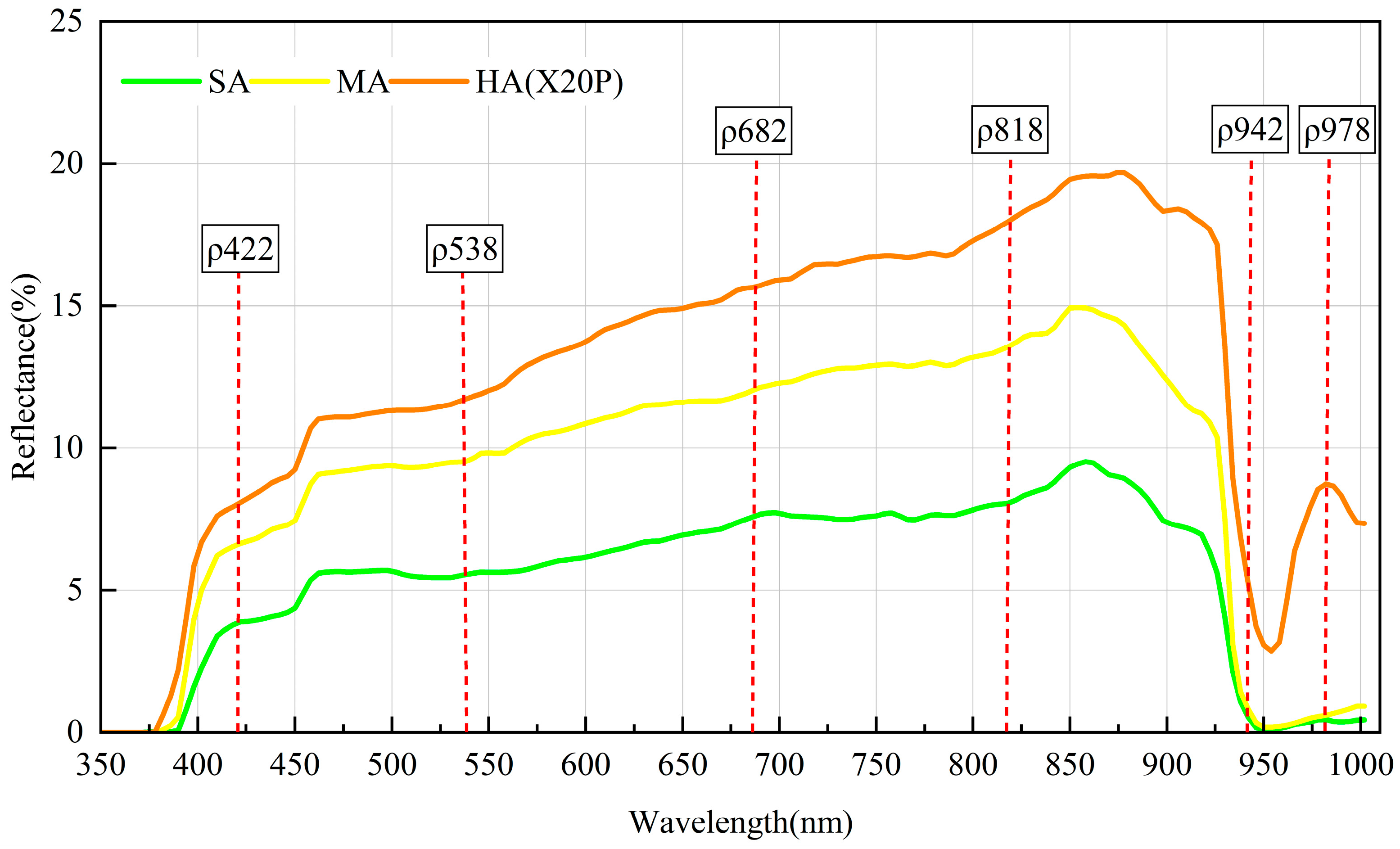
Comparative analysis of hyperspectral reflectance data obtained from the ground-based non-imaging spectrometer and the UAV hyperspectral sensor revealed that the spectral reflectance curves from both sensors exhibited consistent overall trends, though with certain numerical discrepancies. These differences were primarily attributed to factors such as differences in imaging modes (non-imaging vs. imaging), ambient lighting conditions, and atmospheric influences on the reflected radiation measurements [42]. Based on the SPA algorithm results from Section 3.1, this study initially selected six feature bands: 422 nm, 538 nm, 682 nm, 818 nm, 942 nm, and 978 nm (Figure 4).
Due to the limitation in the available spectral range of UAV hyperspectral data and interference from spectral noise, the analysis was confined to the wavelength range of 450–910 nm [43]. Given these constraints in imaging spectral data, only three feature bands remained applicable: 538 nm, 682 nm, and 818 nm. Based on the above analysis, this study ultimately selected two key bands: 538 nm and 818 nm for spectral index construction.
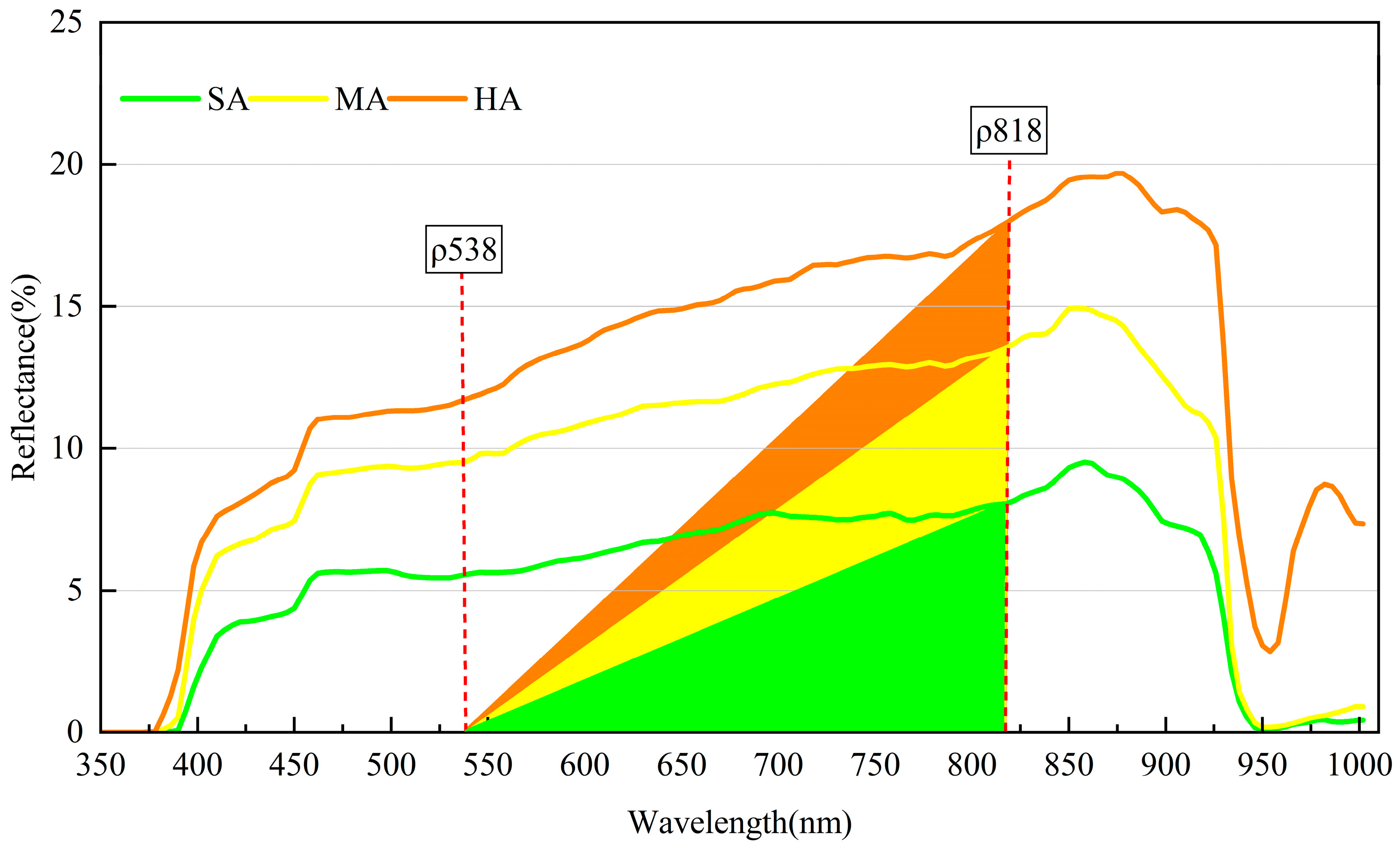
As shown in Figure 5, significant differences were observed in the triangular area formed by the hyperspectral reflectance curves and the feature bands across different aging stages. Therefore, this study proposed the Triangle Aging Index (TAI) for asphalt pavement, calculated as follows:
T A I = ( ρ 818 ρ 538 ) 2 × f ( ρ 818 )
where f ( ρ 818 ) represents the spectral reflectance at the center wavelength of 818 nm. ρ 538 and ρ 818 represent the two wavelengths of 538 nm and 818 nm.

4.3. Aging Assessment Results Based on UAV Hyperspectral Imagery

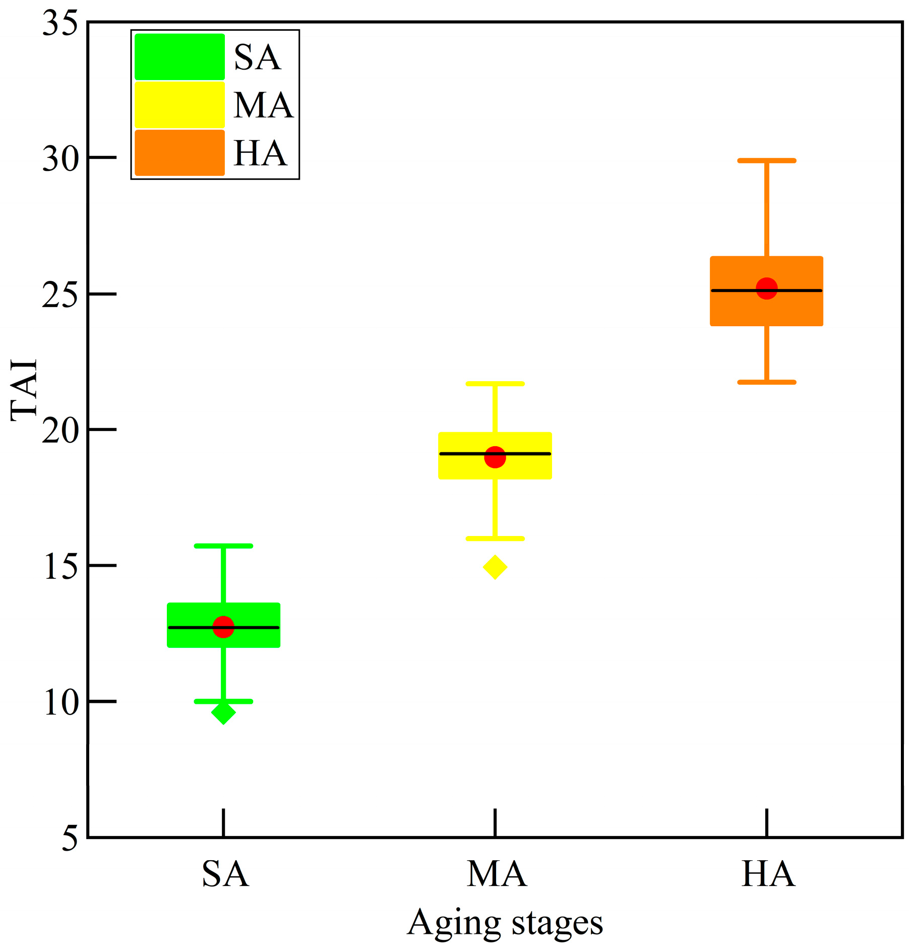
The triangle aging spectral index was applied to UAV hyperspectral imagery to calculate TAI values for the study area. Statistical analysis of TAI values from training samples representing slightly (SA), moderately (MA), and heavily (HA) aging degrees (Figure 6) revealed distinct numerical distribution ranges without overlap among the three aging stages, demonstrating the index’s strong discriminative capability for different aging degrees. Otsu’s segment method was subsequently used to determine classification thresholds for the decision tree algorithm [44]. Considering the randomness in threshold training point selection, multiple repeated experiments were conducted to optimize the threshold values, ultimately establishing 15.97 as the classification threshold between SA and MA, and 22.11 between MA and HA [45]. Using these thresholds, the decision tree algorithm was implemented to assess aging degrees across the study area’s asphalt pavement based on TAI imagery.
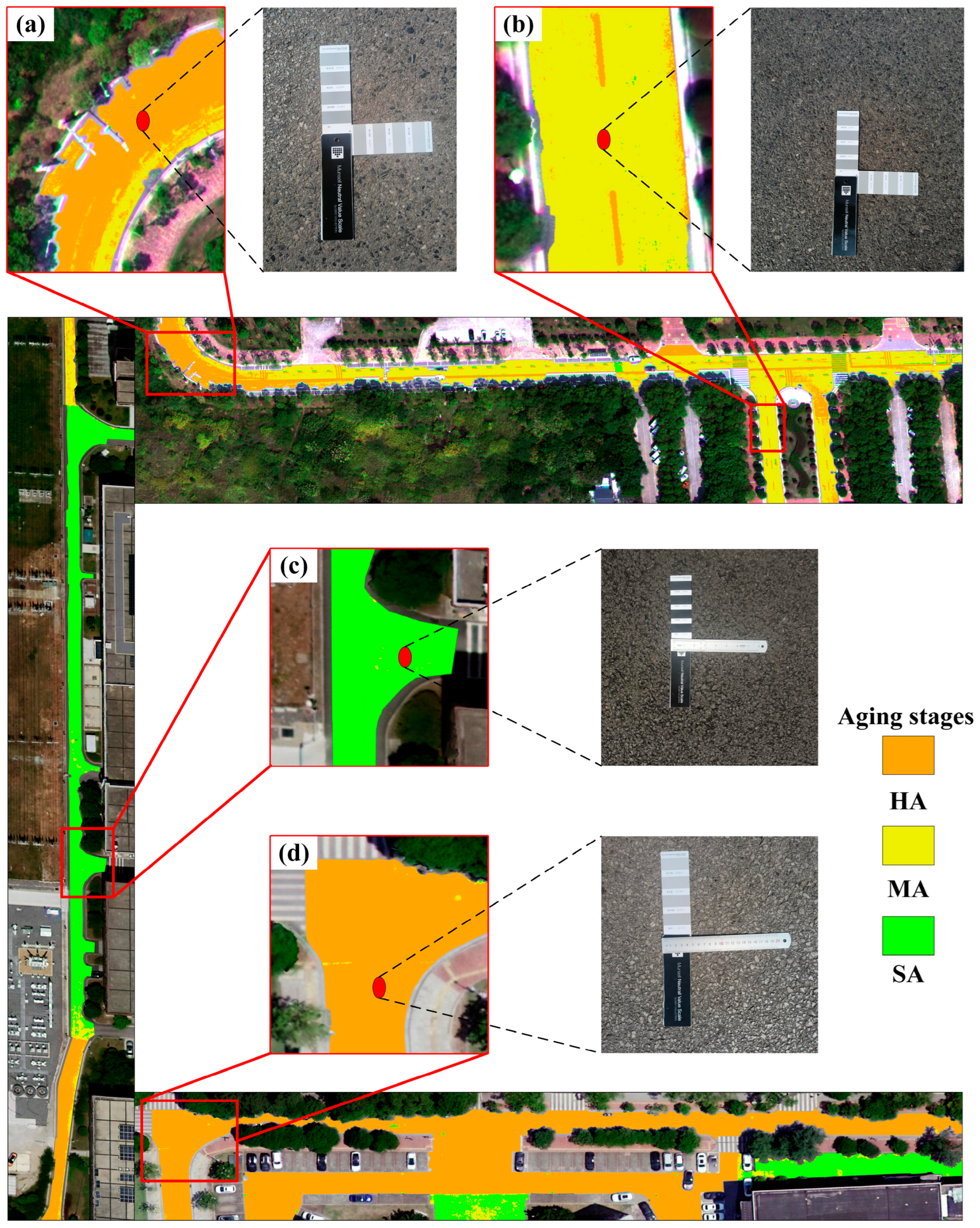
The aging classification results of asphalt pavement in selected road sections of the study area are shown in Figure 7. To verify the assessment accuracy, four typical areas were compared with field investigation results. The verification demonstrates: In the curved section of Figure 7a, the field-measured MNVSC value was 7.0, showing severe texture wear, blunted aggregate edges, and rock-dominated composition, the decision tree assessment result was HA. For Figure 7b, the field-measured MNVSC value was 4.75, exhibiting weakened aggregate–bitumen adhesion, exposed aggregates, and micro-texture abrasion, the decision tree assessment result was MA. In Figure 7c, the field-measured MNVSC value was 3.5, where the asphalt film had mostly disappeared and the seal coat began eroding without aggregate exposure, the decision tree assessment result was SA. Figure 7d represents an intersection with field-measured MNVSC 7.25, displaying complete asphalt erosion, refined mineral particles, and aged smoothness, the decision tree assessment result was HA. These results confirm strong consistency between UAV hyperspectral aging evaluations and field-measured characteristics of pavement degradation.
The quantitative evaluation based on the confusion matrix (Table 2) showed that the overall accuracy (OA) reached 96.52%, with a Kappa coefficient of 0.948 and a macro F1-score of 96.55%. The user’s accuracy and producer’s accuracy for the slightly aged (SA) class were 97.28% and 95.49%, respectively; for the moderately aged (MA) class, 96.50% and 95.05%; and for the heavily aged (HA) class, 96.02% and 99.02%. These results validate the reliability and accuracy of the proposed assessment method.

4.4. Assessment of Asphalt Pavement Skid Resistance

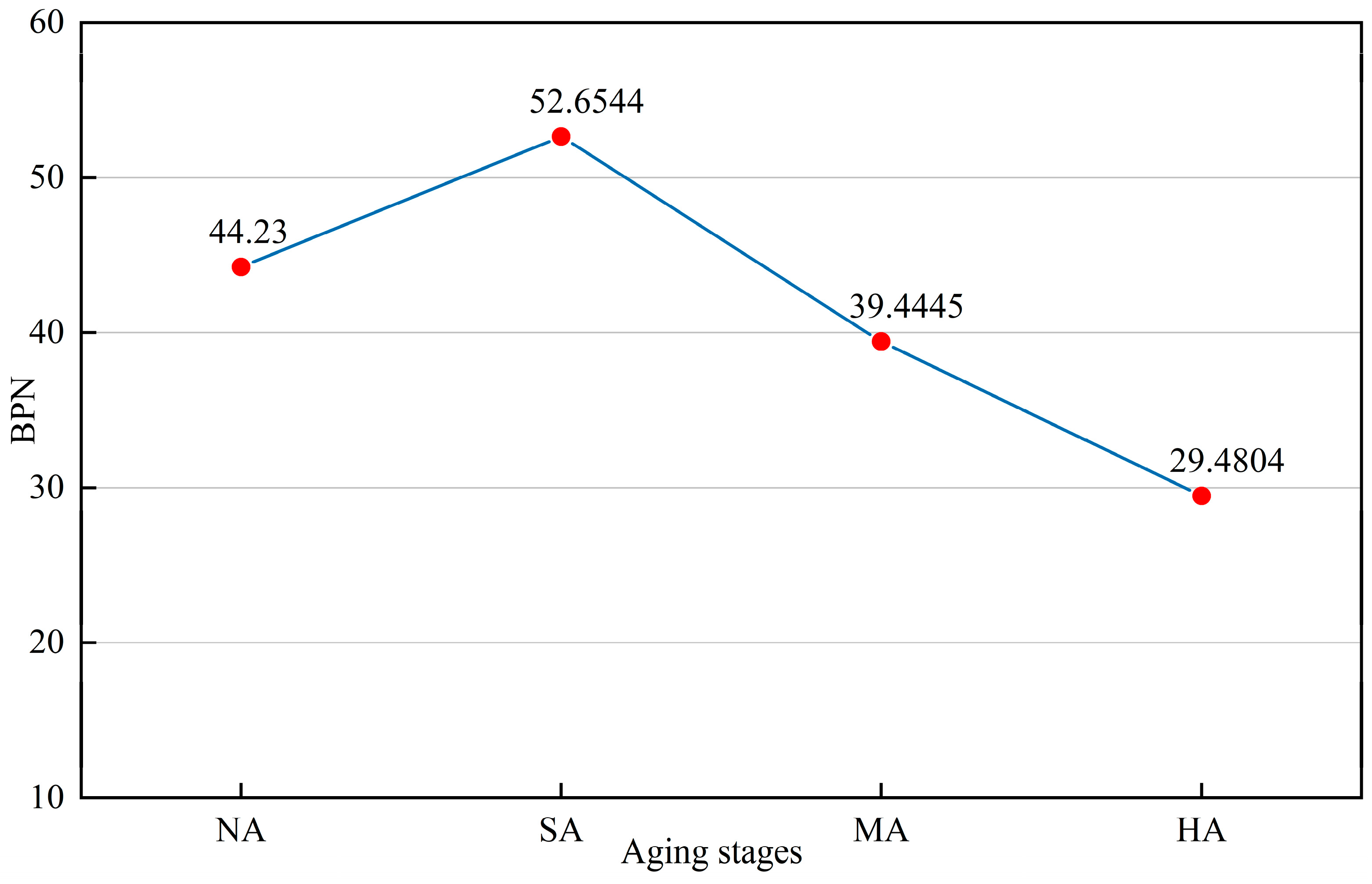
Based on the aging degree assessment results of sample points, the distribution of 196 sample points in the study area was as follows: 16 newly paved asphalt (NA), 50 slightly aged (SA), 80 moderately aged (MA), and 50 heavily aged (HA). Statistical analysis of the BPN values for these sample points (Figure 8) revealed an overall decreasing trend in skid resistance with aging. Specifically, during the initial stage (from new to slight aging pavement), the BPN values exhibited an increasing trend, primarily attributed to the suboptimal initial skid resistance due to bitumen film coverage on newly paved surface. As the bitumen film wore off after short-term traffic service, the aggregate surface texture became fully exposed, leading to a temporary improvement in skid resistance, a phenomenon consistent with existing research findings [46,47,48,49]. In subsequent aging stages, however, the BPN values showed a pronounced downward trend due to the combined effects including continued deterioration of the asphalt seal coat, wear of aggregate angularity, and attenuation of surface texture depth, leading to progressive reduction in skid performance [50].
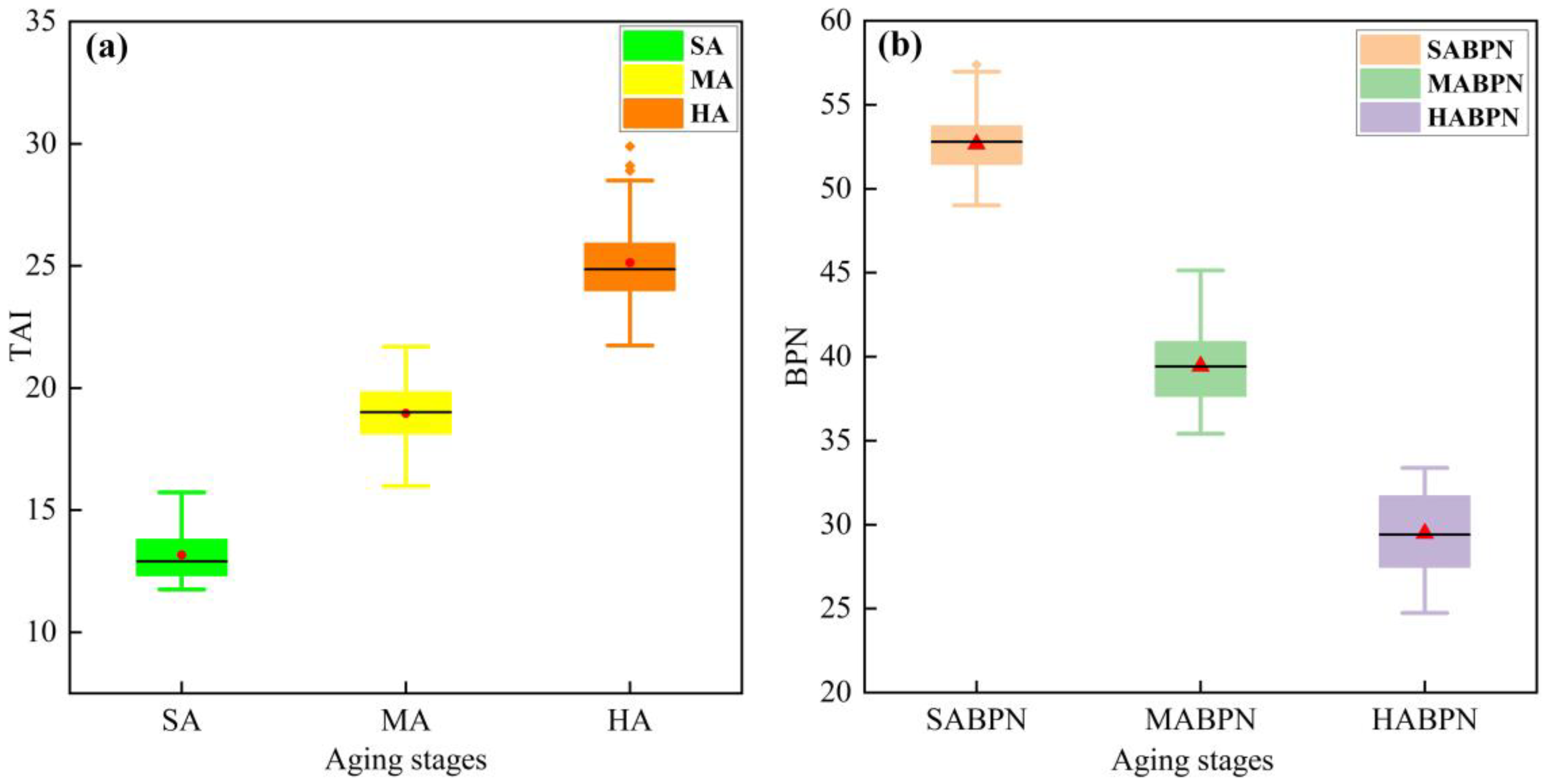
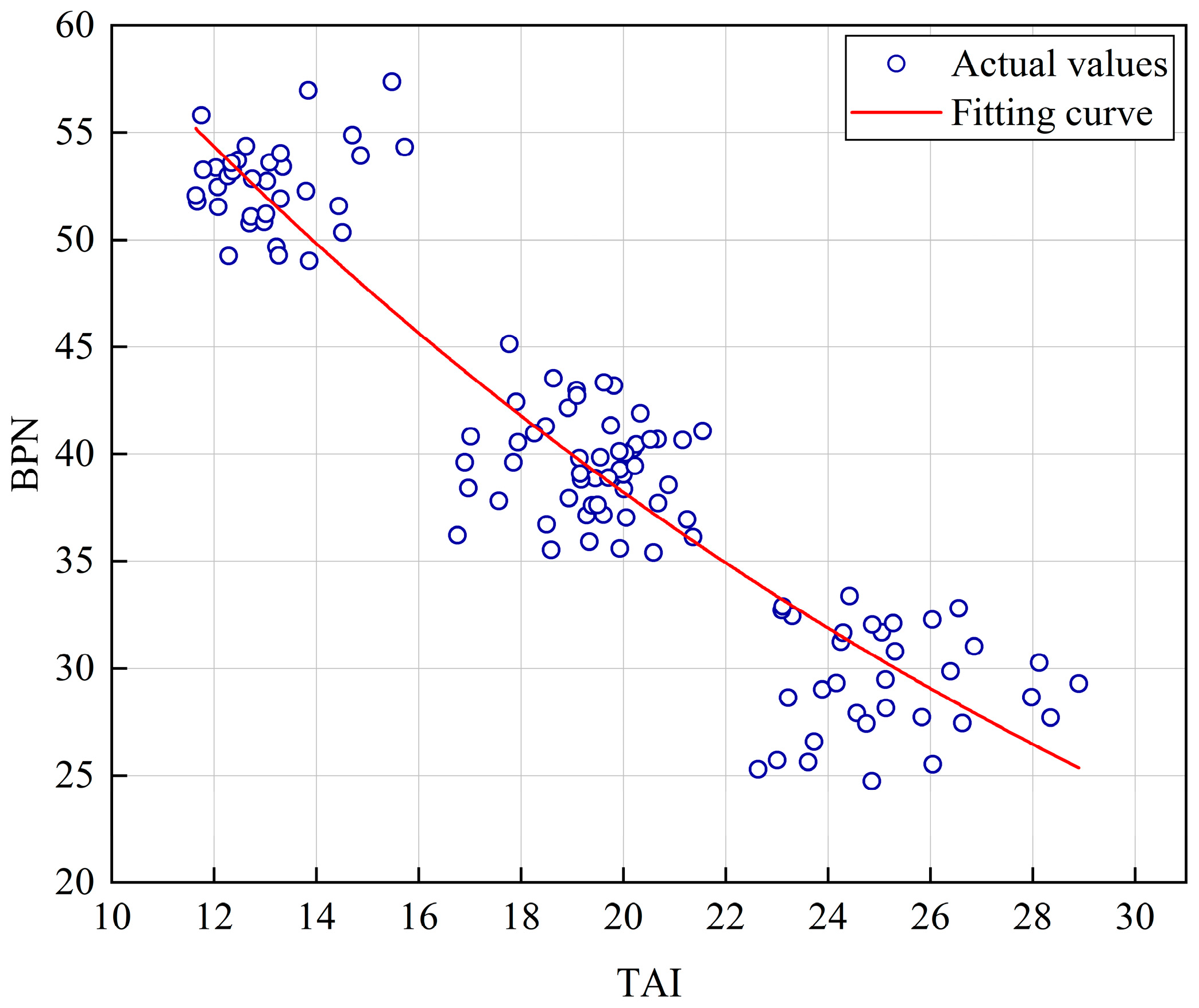
Considering the time-dependent characteristics of skid resistance in newly paved asphalt surfaces, this study excluded 16 newly constructed pavement samples with less than 6 months of service to ensure modeling reliability, retaining 180 valid samples for analysis. Figure 9 presents the statistical relationship between aging stages and both TAI and BPN values. The plot clearly showed that while TAI values increased with advancing aging stages, BPN measurements exhibited a corresponding decrease, reflecting the deterioration of skid resistance performance associated with pavement aging.
Based on the aforementioned analysis, this study established a predictive model using TAI as the independent variable and BPN as the dependent variable through nonlinear least squares regression, formulated as follows:
y = 92.9009 × e x p ( 0.044511 × x )
where y denotes the BPN value, x denotes the mean TAI value of the corresponding area, and exp(·) denotes the natural exponential function.
The model fitting results are shown in Figure 10, with analysis indicates that the distribution of sample points varies across different aging stages. Samples from slightly and moderately aged pavement demonstrated relatively concentrated distributions with good regularity, whereas those in the high-TAI/low-BPN region (representing heavily aging) exhibited more dispersed characteristics. This phenomenon can be attributed to the fact that pavement skid resistance does not continue to decline indefinitely. As aggregate polishing and wear progress, skid resistance eventually stabilizes within a certain range. However, road dust accumulation continues over time, causing further lightening in the pavement surface and continued increases in reflectance.
Statistical validation of the regression model confirmed its significance at the 0.0001 level. Model performance metrics showed a coefficient of determination (R2) of 0.869, indicating strong explanatory power; an Akaike Information Criterion (AIC) of 628.12; a mean absolute percentage error (MAPE) of 6.73%; and a root mean square error (RMSE) of 3.26. These quantitative metrics fully demonstrated that the model achieved both excellent goodness-of-fit and reliable predictive accuracy on the modeling dataset.
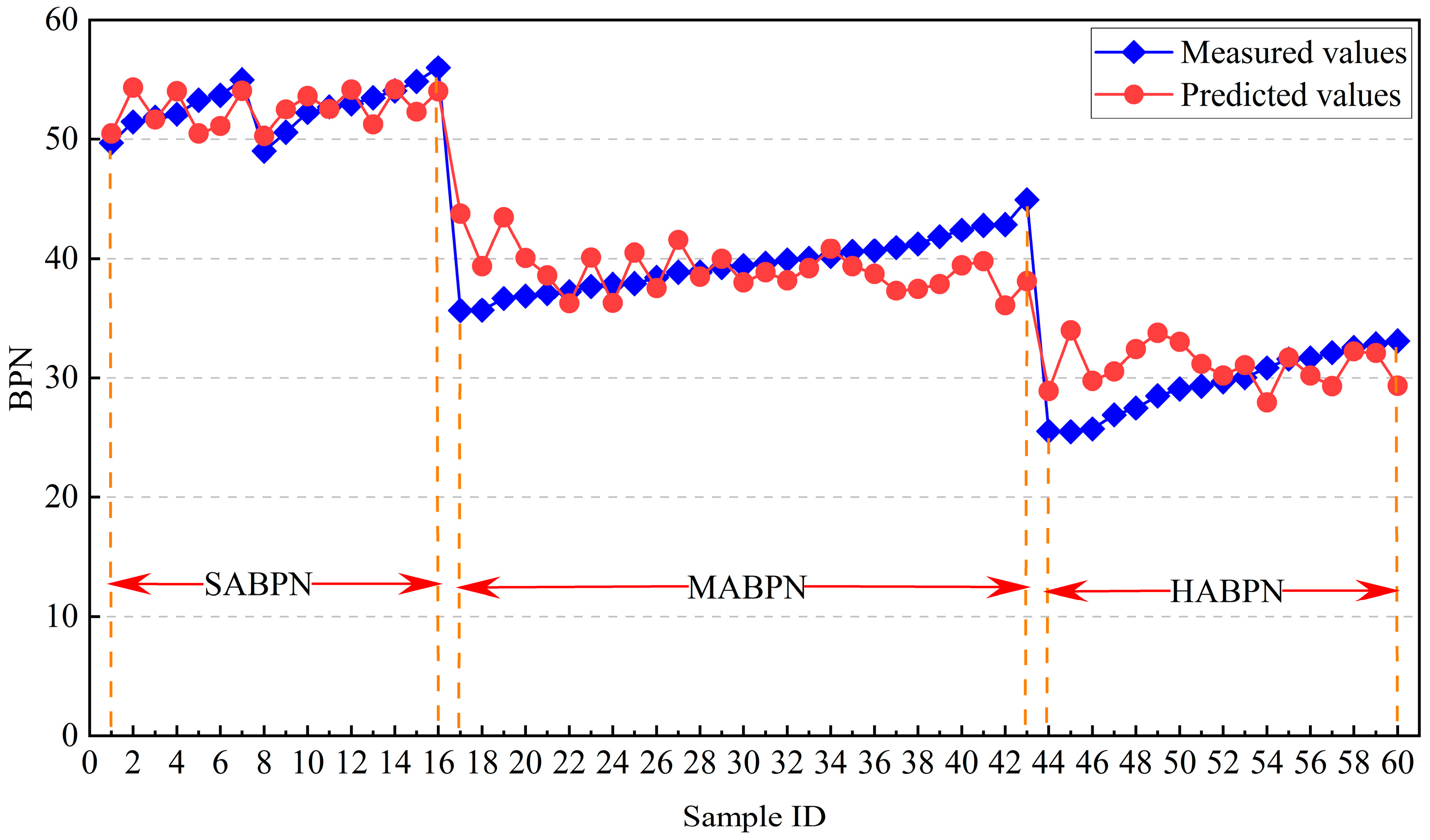
The model was further applied to the validation dataset, where the results showed that the coefficient of determination (R2) reached 0.874, remaining highly consistent with the value of 0.869 obtained for the training set. The MAPE and RMSE were 6.87% and 3.16%, respectively, indicating that the model exhibits strong generalization capability in retrieving BPN based on TAI. Figure 11 presents the comparison between measured and predicted BPN values for the 60 validation samples. To further quantify the error characteristics across different aging stages, a stage-wise statistical analysis of the prediction errors was conducted. For slightly aged (SA) pavements, the mean prediction error was −0.12 BPN with a standard deviation of 1.86, indicating high consistency between predicted and measured values and a relatively concentrated error distribution. For moderately aged (MA) pavements, the mean prediction error increased to −0.38 BPN, with a standard deviation of 3.16. This increase is mainly attributed to spectral fluctuations caused by uneven aggregate exposure and the evolution of micro-texture during the transitional aging stage.
For heavily aged (HA) pavements, the prediction errors exhibited the largest dispersion, with a mean error of 1.49 BPN and a standard deviation of 3.55; however, the error magnitude remained within an acceptable range for engineering applications. The larger errors observed in the HA stage can be primarily attributed to two factors: (1) after aggregate polishing tends to stabilize, the decline in skid resistance becomes relatively stable, while the continued accumulation of surface dust may enhance reflectance variations, thereby weakening the correlation between TAI and BPN; and (2) pavement material heterogeneity (e.g., localized patching or contamination) may introduce additional spectral noise. From an engineering application perspective, although the error levels vary across aging stages, the proposed model effectively captures the overall trend of skid resistance evolution with pavement aging, thereby meeting the practical requirements of network-level skid resistance assessment and maintenance decision making.
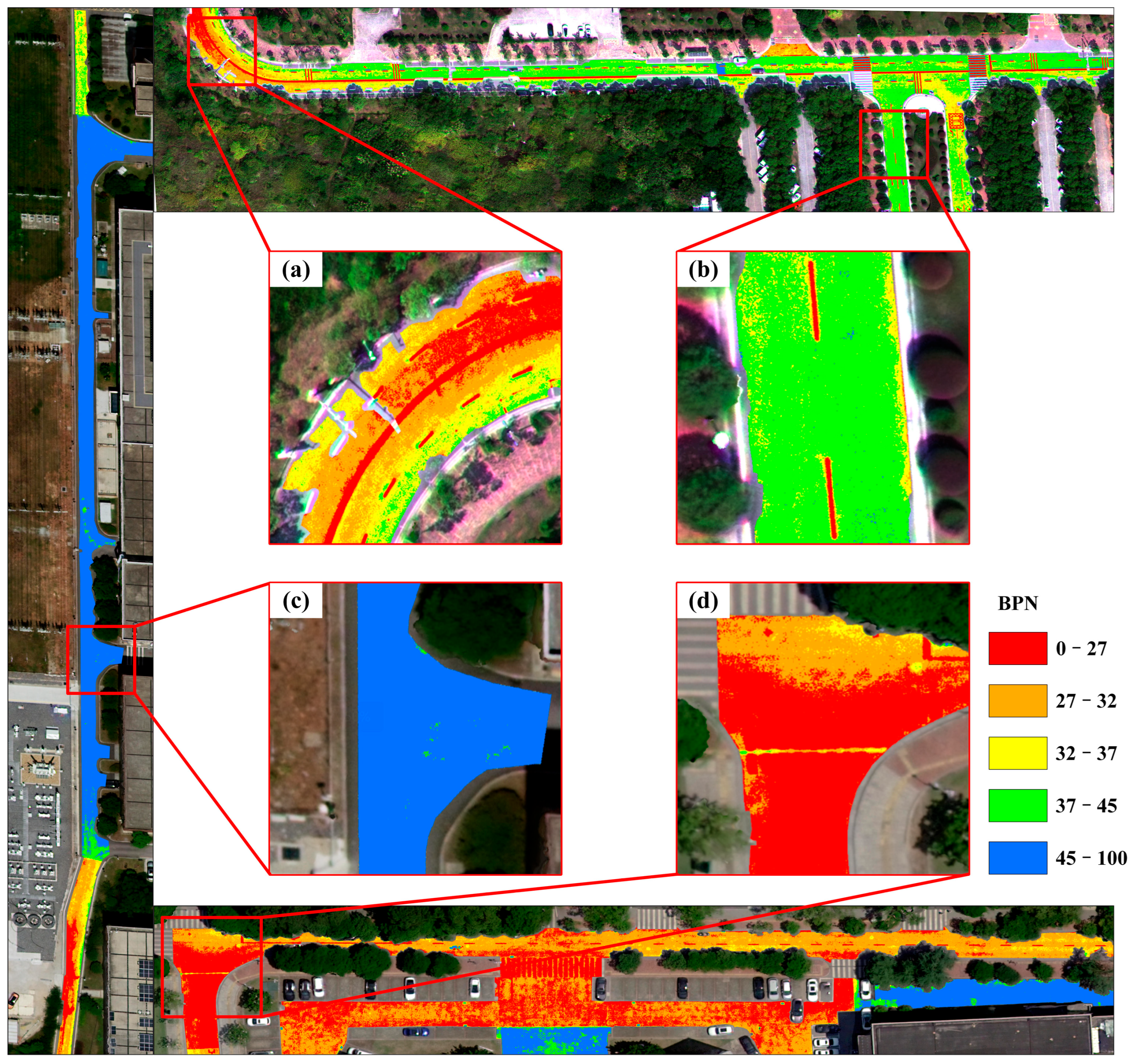
The skid resistance assessment of the study areas based on the regression model (Figure 12) yielded the following key findings: slightly aged areas (Figure 12c) exhibited BPN values predominantly exceeding 45, indicating well-maintained skid resistance performance. Moderately aged areas (Figure 12b) showed BPN values concentrated in the 37–45 range, representing measurable but not yet critical skid resistance degradation. In the heavily aged areas (Figure 12a,d), BPN values consistently fell below 32, demonstrating significant skid resistance deterioration that necessitates prompt maintenance interventions. Additionally, high-braking-frequency areas such as intersections and curves (Figure 12a,d) displayed systematically lower BPN values compared to straight segments, consistent with the accelerated pavement wear mechanism caused by vehicular dynamics.
By comparing the evaluation results of the method proposed in this study with those reported by Carmon et al., it can be found that Carmon et al. constructed and mapped road dynamic friction coefficients based on airborne push-broom hyperspectral imagery using the partial least squares regression (PLSR) method, and their optimal model achieved a coefficient of determination of approximately 0.70 under cross-validation [26]. In contrast, the method proposed in this study achieved a coefficient of determination of 0.869 in the training set and 0.874 in the independent validation set, demonstrating higher consistency and stability. It should be noted that, in terms of data acquisition, Carmon et al. acquired hyperspectral data using an aircraft platform, for which the spatial resolution was relatively low (approximately 1 m) and the cost of a single operation was relatively high; in contrast, this study acquired pavement imagery using a UAV-mounted hyperspectral sensor, featuring higher spatial resolution (up to 3 cm after pan-sharpening) and greater operational flexibility, which is more conducive to refined skid resistance assessment in urban roads and complex traffic scenarios. In terms of methodological strategy and engineering application potential, the study by Carmon et al. [26] focused on directly using imaging spectral information for statistical modeling, whereas imaging hyperspectral data are susceptible to factors such as illumination conditions, observation geometry, and environmental background, and models built directly on this basis may have certain uncertainties in practical applications. In contrast, this study, through a synergistic framework of “ground spectral feature selection–UAV imaging application”, introduced physically meaningful feature bands into UAV hyperspectral image analysis, thereby to a certain extent weakening the influence of differences in environment and imaging conditions on model performance, and thus improving the applicability and transferability of the model across different road scenarios, making it more suitable for non-contact skid resistance assessment at the road-network scale. In addition, the workflow of the proposed method is relatively concise with strong interpretability, and it is easier to integrate with existing road inspection and maintenance systems.

5. Discussion

5.1. Comparison of Aging Spectral Indices with Different Band Combinations

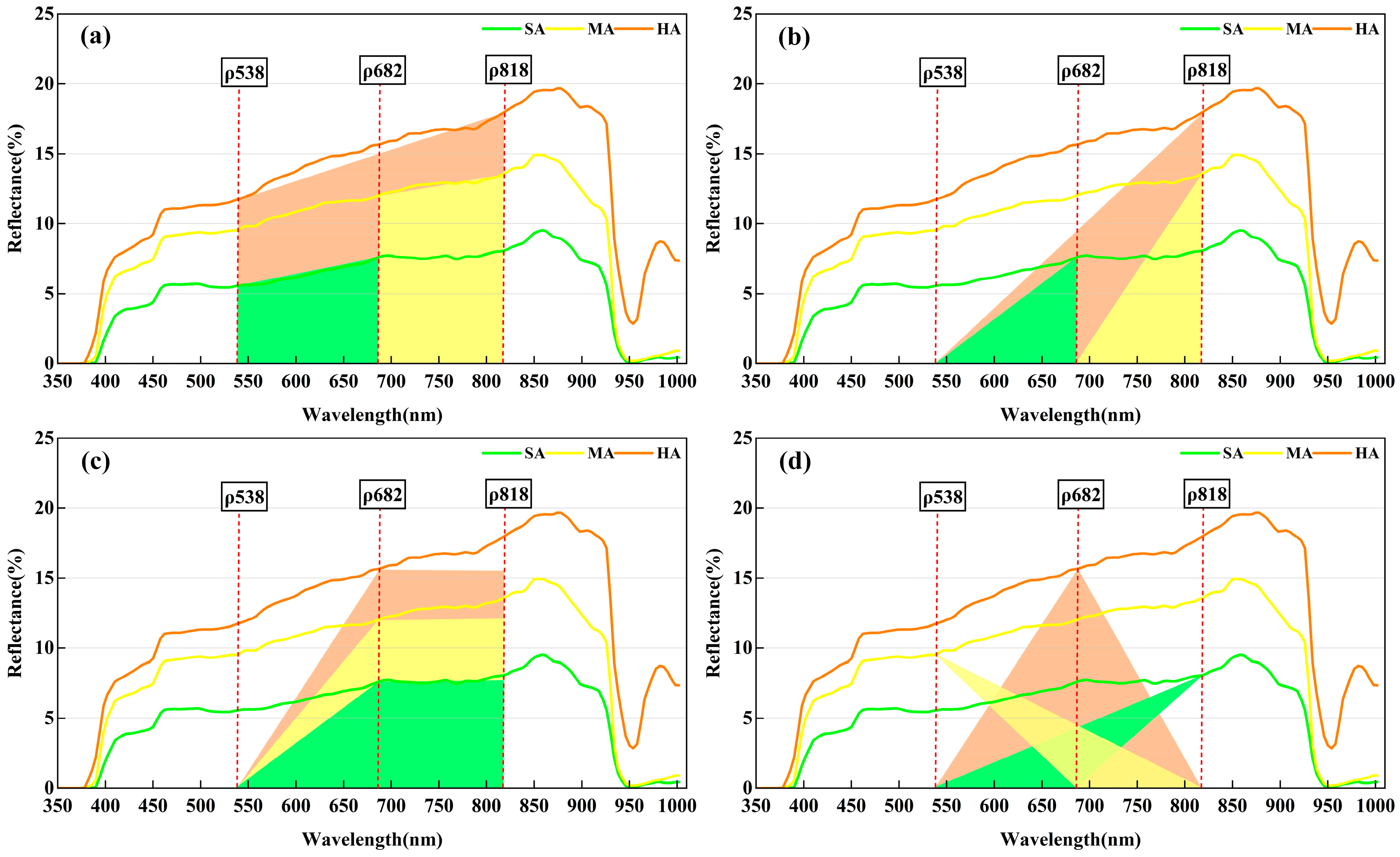
When constructing aging spectral indices for asphalt pavement aging, the selection of spectral bands and the methodology of index construction directly determine the accuracy of aging assessment results. Through comprehensive spectral characteristics analysis and SPA selection results, this study ultimately identified three feature wavelengths at 538 nm, 682 nm, and 818 nm. Given the diversity of band combination approaches, the research further investigated the impact of dual-band and triple-band combinations (including dual-band triangular/trapezoidal indices and triple-band triangular/trapezoidal indices, totaling ten combinations) on the assessment of asphalt pavement aging degree (Figure 13). As shown in Table 3, among dual-band aging spectral indices, those achieving overall accuracy greater than 90% and Macro-F1 score exceeding 90% included: trapezoidal indices with band combinations of 538, 818 nm and 682, 818 nm; and triangular indices with band combinations of 538, 818 nm and 682, 818 nm, among which the triangular index with 538, 818 nm combination demonstrated the highest assessment accuracy. For triple-band combinations, only the triangular index with 538, 682, 818 nm combination showed satisfactory assessment accuracy, while other combinations exhibited overall accuracy below 90%. Therefore, this study ultimately selected the triangular index with 538, 818 nm band combination as the optimal solution.

5.2. Possibility of Study Application

The asphalt pavement skid resistance detection method proposed in this study has been preliminarily validated in the experimental area. Compared with traditional approaches such as manual inspections by maintenance personnel and vehicle-mounted Pavement Management Systems (PMS), this method establishes a quantitative model from the perspective of road spectral features, and realizes more efficient, rapid and large-scale monitoring and assessment of asphalt pavement skid resistance performance through remote sensing, better meeting the needs of road maintenance.
However, when extending the proposed method to large-scale applications, several limiting factors and practical conditions must be carefully considered. First, in terms of data acquisition, dense traffic flow may cause some interference with UAV aerial surveys; however, considering the intermittent nature of traffic flow and the high operational flexibility of UAVs, this influence can usually be controlled by reasonably scheduling flight periods. More importantly, local meteorological conditions and pavement surface states have significant impacts on spectral observations. Pavement wetness, icing, and temperature variations may substantially alter spectral response characteristics; therefore, the current method is more suitable for observation scenarios that are dry, ice-free, and relatively stable in environmental conditions [51]. In practical engineering applications, the timing of data acquisition should be reasonably selected in accordance with meteorological conditions.
In addition, this study selected road sections with relatively smooth surfaces and minimal distress as the study areas, not only to reduce the interference of non-target factors such as cracks and patched areas on spectral responses, but also due to the requirements of skid resistance field testing specifications regarding testing stability and data reliability. Meanwhile, such selection also helps to minimize the influence of surface contaminants and non-ideal observation conditions (such as localized dust, oil stains, or shadows) on spectral observations during the data acquisition stage, thereby ensuring the reliability of the analysis of the relationship between spectral features and skid resistance. Although such relatively ideal pavement conditions are beneficial for the proof-of-concept of the method, they cannot fully represent the complex and diverse pavement conditions of real road networks. In actual road environments, factors such as cracks, patched areas, and localized contamination may jointly act to introduce additional disturbances to spectral features and model prediction results, and their mechanisms require further systematic investigation in subsequent studies [52].
From the perspective of mechanistic interpretation, this study does not assume a strict one-to-one causal relationship between spectral features and skid resistance. The starting point of this study is that pavement aging, as a common physical process, simultaneously leads to asphalt film wear, aggregate exposure, and polishing. These changes not only affect the micro-texture characteristics of the pavement surface but also alter its spectral reflectance properties, thereby resulting in a coupled response between spectral variations and skid resistance degradation under certain physical constraints. At the same time, reflectance variations may also be influenced by factors such as surface color, mineral composition, and pore structure [41]. Therefore, the TAI-BPN relationship established in this study should be interpreted as an empirical–mechanistic relationship oriented toward engineering assessment, rather than a strictly causal inference model.
Finally, when applying the proposed method in different regions, the influence of differences in asphalt pavement materials should also be considered. Variations in aggregate types, gradation, and asphalt materials among different regions may lead to differences in pavement spectral response characteristics. Although the aging spectral analysis framework proposed in this study has a certain degree of theoretical generality, the model parameters still need to be calibrated and optimized according to regional material characteristics in order to improve the robustness and reliability of the method for cross-regional and road-network-scale applications.

6. Conclusions

This study proposes a UAV-based hyperspectral remote sensing method for assessing asphalt pavement skid resistance, revealing spectral response characteristics variations during pavement aging and constructing a triangular spectral index for asphalt pavement aging. Combined with decision tree classification algorithms, the method achieved pavement aging assessment with results demonstrating 96.52% overall accuracy, a Kappa coefficient of 0.948, and an F1-score of 96.55%, confirming its reliability. Furthermore, a quantitative relationship model between the aging spectral index and skid resistance was established, with validation set metrics showing 6.87% MAPE and 3.16 RMSE, indicating good accuracy.
Future work will focus on extending the proposed framework by collecting pavement data from different climatic regions and asphalt mixture types to further calibrate and validate the TAI–BPN model. In complex road environments, surface contaminants and shadow effects may introduce spectral disturbances; therefore, future studies may incorporate shadow detection, contamination identification, or multi-temporal observations to distinguish and correct these influences, thereby improving the robustness of the model under complex pavement conditions. In addition, future research may introduce airborne or ground-based hyperspectral sensors with shortwave infrared (SWIR) coverage or integrating multi-source data fusion approaches to incorporate SWIR information into the analytical framework. Such improvements are expected to enhance the noise resistance, robustness, and physical interpretability of the model, ultimately enabling the development of a more general and transferable framework for pavement skid resistance assessment.

Author Contributions

Conceptualization: Q.X., B.L. and Q.Z.; Methodology: Q.X. and B.L.; Software: Q.X. and Y.Z.; Validation: B.L., X.W. and L.Z.; Formal Analysis: Q.X. and J.S.; Investigation: Q.X., B.L., Y.Z. and X.C.; Resources: X.W., L.Z. and T.H.; Data Curation: Q.X. and J.S.; Writing—Original Draft Preparation: Q.X.; Writing—Review and Editing: Q.Z., B.L. and T.H.; Visualization: Q.X. and Y.Z.; Supervision: Q.Z.; Project Administration: Q.Z.; Funding Acquisition: Q.Z. All authors have read and agreed to the published version of the manuscript.

Funding

This research was supported by the Scientific Research Foundation of Hunan Education Department (23B0327 and 24B0331), Open Fund of Engineering Laboratory of Spatial Information Technology of Highway Geological Disaster Early Warning in Hunan Province (Changsha University of Science & Technology) (kfj210601).

Data Availability Statement

The data that support the findings of this study are available from the corresponding author upon reasonable request.

Acknowledgments

The authors would like to thank all those who provided support during the study.

Conflicts of Interest

No potential conflict of interest was reported by the authors. The sponsors had no role in the design, execution, interpretation, or writing of the study.

Abbreviations

The following abbreviations are used in this manuscript:
UAVUnmanned aerial vehicle
RMSERoot mean square error
R2Coefficient of determination
MNVSCMunsell neutral value scale card
VNIRVisible-near-infrared region
SWIRShort-wave infrared region
NANewly paved asphalt
SASlightly aged
MAModerately aged
HAHeavily aged
SNRSignal-to-noise ratio
BPTBritish pendulum tester
BPNBritish pendulum number
SPASuccessive projections algorithm
CARTClassification and regression tree
PAProducer’s accuracy
UAUser’s accuracy
OAOverall accuracy
TAITriangle aging index
MAPEMean absolute percentage error
AICAkaike information criterion
PMSPavement management systems

References

  1. Maparu, T.S.; Mazumder, T.N. Transport infrastructure, economic development and urbanization in India (1990–2011): Is there any causal relationship? Transp. Res. Part A Policy Pract. 2017, 100, 319–336. [Google Scholar] [CrossRef] [Scilit]
  2. Rubio, M.C.; Martínez, G.; Baena, L.; Moreno, F. Warm mix asphalt: An overview. J. Clean. Prod. 2012, 24, 76–84. [Google Scholar] [CrossRef] [Scilit]
  3. Chen, X.; Wang, Y. Conserving existing road pavements against aging: A new assessment method and evaluation of different techniques. J. Clean. Prod. 2024, 446, 141498. [Google Scholar] [CrossRef] [Scilit]
  4. Qian, G.; Wang, Z.; Yu, H.; Shi, C.; Zhang, C.; Ge, J.; Dai, W. Research on surface texture and skid resistance of asphalt pavement considering abrasion effect. Case Stud. Constr. Mater. 2024, 20, e02949. [Google Scholar] [CrossRef] [Scilit]
  5. Ma, Z.; Wang, H.; Zhang, Y.; Jelagin, D.; Hui, B. Study of the surface texture evolution and friction degradation in asphalt pavements during wear process. Wear 2025, 564, 205714. [Google Scholar] [CrossRef] [Scilit]
  6. Yu, M.; You, Z.; Wu, G.; Kong, L.; Liu, C.; Gao, J. Measurement and modeling of skid resistance of asphalt pavement: A review. Constr. Build. Mater. 2020, 260, 119878. [Google Scholar] [CrossRef] [Scilit]
  7. Chen, S.; Liu, X.; Luo, H.; Yu, J.; Chen, F.; Zhang, Y.; Ma, T.; Huang, X. A state-of-the-art review of asphalt pavement surface texture and its measurement techniques. J. Road Eng. 2022, 2, 156–180. [Google Scholar] [CrossRef] [Scilit]
  8. Fuentes, L.; Gunaratne, M.; Hess, D. Evaluation of the effect of pavement roughness on skid resistance. J. Transp. Eng. 2010, 136, 640–653. [Google Scholar] [CrossRef] [Scilit]
  9. Wasilewska, M.; Gardziejczyk, W.; Gierasimiuk, P. Comparison of measurement methods used for evaluation the skid resistance of road pavements in Poland–case study. Int. J. Pavement Eng. 2020, 21, 1662–1668. [Google Scholar] [CrossRef] [Scilit]
  10. Zhao, W.; Zhang, J.; Lai, J.; Shi, X.; Xu, Z. Skid resistance of cement concrete pavement in highway tunnel: A review. Constr. Build. Mater. 2023, 406, 133235. [Google Scholar] [CrossRef] [Scilit]
  11. Herold, M.; Roberts, D. Spectral characteristics of asphalt road aging and deterioration: Implications for remote-sensing applications. Appl. Opt. 2005, 44, 4327–4334. [Google Scholar] [CrossRef] [Scilit] [PubMed]
  12. Mettas, C.; Themistocleous, K.; Neocleous, K.; Christofe, A.; Pilakoutas, K.; Hadjimitsis, D. Monitoring asphalt pavement damages using remote sensing techniques. In Proceedings of the Third International Conference on Remote Sensing and Geoinformation of the Environment (RSCy2015), Paphos, Cyprus, 16–19 March 2015; pp. 237–248. [Google Scholar]
  13. Herold, M.; Roberts, D.; Smadi, O.; Noronha, V. Road condition mapping with hyperspectral remote sensing. In Proceedings of the 2004 AVIRIS Workshop, Pasadena, CA, USA, 31 March–2 April 2004. [Google Scholar]
  14. Hou, X.; Liang, B.; Xiao, F.; Wang, J.; Wang, T. Characterizing asphalt aging behaviors and rheological properties based on spectrophotometry. Constr. Build. Mater. 2020, 256, 119401. [Google Scholar] [CrossRef] [Scilit]
  15. Mohammadi, M. Road classification and condition determination using hyperspectral imagery. Int. Arch. Photogramm. Remote Sens. Spat. Inf. Sci. 2012, 39, 141–146. [Google Scholar] [CrossRef] [Scilit]
  16. Herold, M.; Roberts, D.; Noronha, V.; Smadi, O. Imaging spectrometry and asphalt road surveys. Transp. Res. Part C Emerg. Technol. 2008, 16, 153–166. [Google Scholar] [CrossRef] [Scilit]
  17. Herold, M.; Roberts, D.A.; Gardner, M.E.; Dennison, P.E. Spectrometry for urban area remote sensing—Development and analysis of a spectral library from 350 to 2400 nm. Remote Sens. Environ. 2004, 91, 304–319. [Google Scholar] [CrossRef] [Scilit]
  18. Yao, H.; Qin, R.; Chen, X. Unmanned Aerial Vehicle for Remote Sensing Applications—A Review. Remote Sens. 2019, 11, 1443. [Google Scholar] [CrossRef] [Scilit]
  19. Chen, X.; Zhang, X.; Ren, M.; Zhou, B.; Sun, M.; Feng, Z.; Chen, B.; Zhi, X. A multiscale enhanced pavement crack segmentation network coupling spectral and spatial information of UAV hyperspectral imagery. Int. J. Appl. Earth Obs. Geoinf. 2024, 128, 103772. [Google Scholar] [CrossRef] [Scilit]
  20. Jeong, K.-d.; Jang, J.; Shin, S.P.; Shin, J.-i. Evaluation of asphalt pavement condition using hyper-spectral images. J. Korean Asph. Inst. 2024, 13, 322–328. [Google Scholar] [CrossRef]
  21. Pietersen, R.A.; Robinson, B.M.; Diltz, R.A.; Einstein, H.H. In-scene material detection for real-time autonomous hyperspectral reflectance correction. In Proceedings of the Image Sensing Technologies: Materials, Devices, Systems, and Applications XI, National Harbor, MD, USA, 22–24 April 2024; pp. 60–74. [Google Scholar]
  22. Lee, K.; Kim, K.S.; Park, J.; Hong, G. Spectrum Index for Estimating Ground Water Content Using Hyperspectral Information. Sustainability 2022, 14, 14318. [Google Scholar] [CrossRef] [Scilit]
  23. López-González, P.J.; Reyes-González, D.; Moreno-Vázquez, O.; Vivar-Ocampo, R.; Zamora-Castro, S.A.; Santos Cortés, L.d.C.; Trujillo-García, B.S.; Sangabriel-Lomelí, J. Inspection and Evaluation of Urban Pavement Deterioration Using Drones: Review of Methods, Challenges, and Future Trends. Future Transp. 2026, 6, 10. [Google Scholar] [CrossRef] [Scilit]
  24. Lee, K.; Park, J.; Hong, G. Prediction of water content in subgrade soil in road construction using hyperspectral information obtained through UAV. Appl. Sci. 2024, 14, 1248. [Google Scholar] [CrossRef] [Scilit]
  25. Carmon, N.; Ben-Dor, E. Rapid assessment of dynamic friction coefficient of asphalt pavement using reflectance spectroscopy. IEEE Geosci. Remote Sens. Lett. 2016, 13, 721–724. [Google Scholar] [CrossRef] [Scilit]
  26. Carmon, N.; Ben-Dor, E. Mapping asphaltic roads’ skid resistance using imaging spectroscopy. Remote Sens. 2018, 10, 430. [Google Scholar] [CrossRef] [Scilit]
  27. JTG D50-2017; Specifications for Design of Highway Asphalt Pavement. CCCC Road and Bridge Consultants Co., Ltd.: Beijing, China, 2017.
  28. CJJ 169-2011; Code for Pavement Design of Urban Road. Ministry of Housing and Urban-Rural Development (MOHURD): Beijing, China, 2011.
  29. JTG 3450-2019; Field Test Methods of Highway Subgrade and Pavement. Research Institute of Highway (RIOH): Beijing, China, 2020.
  30. Mettas, C.; Evagorou, E.; Agapiou, A.; Hadjimitsis, D. The Use of Colorimeters to Support Remote Sensing Techniques on Asphalt Pavements. Remote Sens. 2020, 12, 3911. [Google Scholar] [CrossRef] [Scilit]
  31. Chen, X.; Zhang, X.; Li, J.; Ren, M.; Zhou, B. A New Method for Automated Monitoring of Road Pavement Aging Conditions Based on Recurrent Neural Network. IEEE Trans. Intell. Transp. Syst. 2022, 23, 24510–24523. [Google Scholar] [CrossRef] [Scilit]
  32. Emery, W.; Yerasi, A.; Longbotham, N.; Pacifici, F. Assessing paved road surface condition with high resolution satellite imagery. In Proceedings of the IEEE International Geoscience and Remote Sensing Symposium (IGARSS), Quebec, QC, Canada, 13–18 July 2014; pp. 13–18. [Google Scholar]
  33. Mei, A.; Salvatori, R.; Fiore, N.; Allegrini, A.; D’Andrea, A. Integration of Field and Laboratory Spectral Data with Multi-Resolution Remote Sensed Imagery for Asphalt Surface Differentiation. Remote Sens. 2014, 6, 2765–2781. [Google Scholar] [CrossRef] [Scilit]
  34. Mei, A.; Manzo, C.; Bassani, C.; Salvatori, R.; Allegrini, A. Bitumen removal determination on asphalt pavement using digital imaging processing and spectral analysis. Open J. Appl. Sci. 2014, 4, 366–374. [Google Scholar] [CrossRef]
  35. Araújo, M.C.U.; Saldanha, T.C.B.; Galvao, R.K.H.; Yoneyama, T.; Chame, H.C.; Visani, V. The successive projections algorithm for variable selection in spectroscopic multicomponent analysis. Chemom. Intell. Lab. Syst. 2001, 57, 65–73. [Google Scholar] [CrossRef] [Scilit]
  36. Soares, S.F.C.; Gomes, A.A.; Araujo, M.C.U.; Galvão Filho, A.R.; Galvão, R.K.H. The successive projections algorithm. TrAC Trends Anal. Chem. 2013, 42, 84–98. [Google Scholar] [CrossRef] [Scilit]
  37. Breiman, L.; Friedman, J.; Olshen, R.A.; Stone, C.J. Classification and Regression Trees; Chapman and Hall/CRC: London, UK, 2017. [Google Scholar]
  38. Maxwell, A.E.; Warner, T.A.; Fang, F. Implementation of machine-learning classification in remote sensing: An applied review. Int. J. Remote Sens. 2018, 39, 2784–2817. [Google Scholar] [CrossRef] [Scilit]
  39. Manzo, C.; Mei, A.; Salvatori, R.; Bassani, C.; Allegrini, A. Spectral modelling used to identify the aggregates index of asphalted surfaces and sensitivity analysis. Constr. Build. Mater. 2014, 61, 147–155. [Google Scholar] [CrossRef] [Scilit]
  40. Yuan, H.; Zheng, J.; Lai, L.L.; Tang, Y.Y. A constrained least squares regression model. Inf. Sci. 2018, 429, 247–259. [Google Scholar] [CrossRef] [Scilit]
  41. Patel, V.D.; Kumar, A.; Bharti, R.; Choudhary, R.; Kumar, A. Evaluation of spectral characteristics of asphalt mixtures. J. Mater. Civ. Eng. 2023, 35, 04023295. [Google Scholar] [CrossRef] [Scilit]
  42. Andreou, C.; Karathanassi, V.; Kolokoussis, P. Investigation of hyperspectral remote sensing for mapping asphalt road conditions. Int. J. Remote Sens. 2011, 32, 6315–6333. [Google Scholar] [CrossRef] [Scilit]
  43. Sankararao, A.U.; Saikiran, K.; Rajalakshmi, P. Hyperspectral image denoising: A comparative study on uav based vegetation data. In Proceedings of the 2023 13th Workshop on Hyperspectral Imaging and Signal Processing: Evolution in Remote Sensing (WHISPERS), Athens, Greece, 31 October–2 November 2023; pp. 1–5. [Google Scholar]
  44. Otsu, N. A threshold selection method from gray-level histograms. Automatica 1975, 11, 23–27. [Google Scholar] [CrossRef] [Scilit]
  45. Purwanto, A.D.; Wikantika, K.; Deliar, A.; Darmawan, S. Decision tree and random forest classification algorithms for mangrove forest mapping in Sembilang National Park, Indonesia. Remote Sens. 2022, 15, 16. [Google Scholar] [CrossRef] [Scilit]
  46. Wang, H.; Fan, W.; Chi, M.; Li, Y.; Zhang, X.; Xu, Z.; Jiang, S. Wear resistance and skid resistance of 100% reclaimed asphalt pavement. Constr. Build. Mater. 2025, 468, 140373. [Google Scholar] [CrossRef] [Scilit]
  47. Wu, X.; Zheng, N.; Lei, J. Influencing factors and mechanism for the attenuation of the skid resistance for bauxite clinker-asphalt mixtures. Constr. Build. Mater. 2021, 283, 122670. [Google Scholar] [CrossRef] [Scilit]
  48. He, Y.; Fan, Z.; Yang, X.; Wang, D.; Zhao, Z.; Lu, G.; Lv, S. Study on the influence of tire polishing on surface texture durability and skid resistance deterioration of asphalt pavement. Wear 2024, 556, 205518. [Google Scholar] [CrossRef] [Scilit]
  49. Kane, M.; Edmondson, V. Modelling the bitumen scour effect: Enhancement of a dynamic friction model to predict the skid resistance of rubber upon asphalt pavement surfaces subjected to wear by traffic polishing. Wear 2018, 400, 100–110. [Google Scholar] [CrossRef] [Scilit]
  50. Zhu, S.; Ji, X.; Yuan, H.; Li, H.; Xu, X. Long-term skid resistance and prediction model of asphalt pavement by accelerated pavement testing. Constr. Build. Mater. 2023, 375, 131004. [Google Scholar] [CrossRef] [Scilit]
  51. Deo, R.N.; Sounthararajah, A.; Kodikara, J. Reflectance spectroscopy of asphalt pavement under moisture and diesel perturbations: A laboratory study. Constr. Build. Mater. 2024, 415, 135076. [Google Scholar] [CrossRef] [Scilit]
  52. Abdellatif, M.; Peel, H.; Cohn, A.G.; Fuentes, R. Pavement crack detection from hyperspectral images using a novel asphalt crack index. Remote Sens. 2020, 12, 3084. [Google Scholar] [CrossRef] [Scilit]
Figure 1. Overview of the study areas. (a) Unmanned aerial vehicle (UAV) survey area 1, Forestry University section; (b) UAV survey area 2, University of Technology section; (c) UAV survey area 3, Agricultural University section.
Drones 10 00209 g001
Figure 2. The flowchart of methodology.
Drones 10 00209 g002
Figure 3. Hyperspectral reflectance curves of asphalt pavements at different aging stages: (a) new asphalt pavement (NA); (b) slightly aged asphalt pavement (SA); (c) moderately aged asphalt pavement (MA); and (d) heavily aged asphalt pavement (HA).
Drones 10 00209 g003
Figure 4. Initially selected feature bands.
Drones 10 00209 g004
Figure 5. Construction of the triangle aging spectral index for asphalt pavement.
Drones 10 00209 g005
Figure 6. Statistical TAI results for asphalt pavements at different aging stages.
Drones 10 00209 g006
Figure 7. Assessment results of pavement aging on selected roads in the study area using UAV hyperspectral data. Subfigures (ad) show the classified aging stage and corresponding field measurement for each area: (a) heavily aged pavement area with field measurement comparison; (b) moderately aged pavement area with field measurement comparison; (c) slightly aged pavement area with field measurement comparison; (d) another heavily aged pavement area with field measurement comparison.
Drones 10 00209 g007
Figure 8. Statistical results of British Pendulum Number (BPN) values for asphalt pavements at different aging stages.
Drones 10 00209 g008
Figure 9. Statistical results of Triangle Aging Index (TAI) and BPN variations across asphalt pavements at different aging stages. Subfigure (a) shows the distribution of TAI values for slightly aged (SA), moderately aged (MA), and heavily aged (HA) asphalt pavements; subfigure (b) shows the distribution of BPN values for slightly aged, moderately aged, and heavily aged asphalt pavements, denoted as SABPN, MABPN, and HABPN, respectively.
Drones 10 00209 g009
Figure 10. Nonlinear regression fitting curve between BPN and TAI.
Drones 10 00209 g010
Figure 11. Comparison between measured and predicted BPN values.
Drones 10 00209 g011
Figure 12. Assessment results of skid resistance on selected road sections in the study area. Subfigures (ad) show enlarged views of representative local areas extracted from the overall assessment map: (a) a curved road section; (b) a straight road section; (c) a local section adjacent to the roadside area; and (d) a curved intersection-transition section, illustrating the spatial variation in skid resistance across different typical pavement scenarios.
Drones 10 00209 g012
Figure 13. Geometric structures of aging spectral indices under different band combinations. (a) two-band trapezoidal index; (b) two-band triangular index; (c) three-band trapezoidal index; (d) three-band triangular index.
Drones 10 00209 g013
Table 1. ISCC-NBS Color Names, Munsell Neutral Value Scale Card (MNVSC) Values and Spectral Reflectance Corresponding to Three Pavement Aging Degrees.
Color NameValueReflectance (%)Asphalt Pavement Condition
Black[N0.5/, N2.25/][0.6, 3.8]Slightly aged
Dark Gray to Black(N2.25/, N2.75/](3.8, 5.5]
Dark Gray(N2.75/, N4.25/](5.5,1 3.7]
Medium to Dark Gray(N4.25/, N4.75/](13.7, 17.6]Moderately aged
Medium Gray(N4.75/, N6.25/](17.6, 33.0]
Medium to Light Gray(N6.25/, N6.75/](33.0, 39.5]
Light Gray(N6.75/, N8.25/](39.5, 63.6]Heavily aged
White to Light Gray(N8.25/, N8.75/](63.6, 73.4)
White(N8.75/, N9.5/](73.4, 90.0)Non-existent
Table 2. Evaluation of aging assessment results.
SAMAHAPA
SA103849095.49%
MA2917666395.05%
HA015152199.02%
UA97.28%96.50%96.02%
Kappa0.948Macro-F196.55%
Table 3. Accuracy of Asphalt Pavement Aging Assessment Results under Different Band Combinations.
Dual-Band CombinationTriple-Band Combination
TypesTrapezoidal IndexTriangular IndexTrapezoidal IndexTriangular Index
Wavelength (nm)538–818538–682682–818538–818538–682682–818538–682–818538–818–682538–682–818682–818–538
Threshold values27.2513.2814.6715.977.317.7621.1314.228.215.57
37.9518.4020.3422.1110.2410.7429.5919.9211.377.84
Kappa0.900.830.930.950.820.920.800.810.930.80
OA/%93.0488.1095.0996.5287.2894.2986.3086.6195.4486.41
Macro-F1/%93.4288.7095.2496.5587.6294.1786.4786.8095.3887.05
Disclaimer/Publisher’s Note: The statements, opinions and data contained in all publications are solely those of the individual author(s) and contributor(s) and not of MDPI and/or the editor(s). MDPI and/or the editor(s) disclaim responsibility for any injury to people or property resulting from any ideas, methods, instructions or products referred to in the content.