


Abstract
The integration of large models and multimodal foundation models into the low-altitude economy is driving a transformative shift, enabling intelligent, autonomous, and efficient operations for low-altitude vehicles (LAVs). This article provides a comprehensive analysis of the role these large models play within the smart integrated lower airspace system (SILAS), focusing on their applications across the four fundamental networks: facility, information, air route, and service. Our analysis yields several key findings, which pave the way for enhancing the application of large models in the low-altitude economy. By leveraging advanced capabilities in perception, reasoning, and interaction, large models are demonstrated to enhance critical functions such as high-precision remote sensing interpretation, robust meteorological forecasting, reliable visual localization, intelligent path planning, and collaborative multi-agent decision-making. Furthermore, we find that the integration of these models with key enabling technologies, including edge computing, sixth-generation (6G) communication networks, and integrated sensing and communication (ISAC), effectively addresses challenges related to real-time processing, resource constraints, and dynamic operational environments. Significant challenges, including sustainable operation under severe resource limitations, data security, network resilience, and system interoperability, are examined alongside potential solutions. Based on our survey, we discuss future research directions, such as the development of specialized low-altitude models, high-efficiency deployment paradigms, advanced multimodal fusion, and the establishment of trustworthy distributed intelligence frameworks. This survey offers a forward-looking perspective on this rapidly evolving field and underscores the pivotal role of large models in unlocking the full potential of the next-generation low-altitude economy.
1. Introduction
Benefiting from the rapid evolution of aircraft such as unmanned aerial vehicles (UAVs), electric vertical takeoff and landing (eVTOL) aircraft, and rotorcraft, the development of low-altitude vehicles (LAVs) has given rise to a wide range of civilian and commercial applications, bringing to a transformative shift in daily life [1,2]. In particular, commercial LAVs have significant potential as the center of technological innovation, accelerating growth in the low-altitude economy. Endowing fast deployment and relocation capabilities, LAVs enable numerous untapped applications, ranging from traffic surveillance, crop monitoring, and border patrolling to disaster management [3]. The low-altitude economy is expected to form a new economic ecosystem through the widespread use of LAVs in low-altitude airspace. LAVs flying in the sky not only serve as a platform for technological innovation but also create new applications across various scenarios. The total number of LAV sales was 8.19 million in 2024 and is expected to exceed 9 million by 2029 [4]. The scale of the UAV industry is potentially enormous with realistic predictions of 80 billion for the U.S. economy alone, and is expected to create tens of thousands of new jobs within the next decade [5]. Because of this widespread application scenario, the requirement for establishing common rules and regulations for operating LAVs in controlled and uncontrolled airspace becomes evident.
To manage the aviation environment and support space service, airworthiness principles and operational procedures of LAVs are managed by regulatory authorities. In the United States, Federal Aviation Administration (FAA) NextGen office released a revised Unmanned Aerial System (UAS) Traffic Management (UTM) Concept of Operations, aiming to describe the operational and technical requirements for a UTM ecosystem able to support the operation of UASs in all existing airspaces [6]. The European Union within the Single European Sky ATM Research (SESAR) project CORUS has published the European-wide Concept of Operations (ConOps), characterizing the four-phase implementation of procedures and services to support operations of UASs at low altitudes [7]. In China, the National Air Traffic Management Committee issued the national airspace basic classification method (Draft) to specialize the regulations and clarify the applicable conditions of air traffic control [8]. The United States and Europe manage UTM using strategic deconfliction, tactical separation, and onboard DAA (Detect and Avoid) as the shared baseline for safety and operations. In the United States, low-altitude aviation management follows a policy–operations–service chain [9]. The FAA sets policies, standards, and certification requirements. The Air Traffic Organization (ATO) provides the air navigation interface and ensures interoperability between existing Air Traffic Management (ATM) and UTM policies. The National Aeronautics and Space Administration (NASA) conducts research and validates new concepts. UAS Service Suppliers (USSs) deliver UTM services directly to operators. In Europe, the European Union Aviation Safety Agency (EASA) and SESAR advance the capabilities of the framework through phased implementations [10,11]. U1 provides registration and network identification. U2 introduces trajectory-based planning and strategic conflict resolution. U3 delivers dynamic capacity management and tactical separation in collaboration with ATC (air traffic control). U4 targets higher automation and service expansion.
To meet the communication requirement of low-altitude economies, abundant efforts have been implemented by the 3rd Generation Partnership Project (3GPP) to enable LAVs to achieve high-speed, ultra-reliable and low-latency communications. The 3GPP specifies the communication requirements for two types of links between Ground BS and UAV in 2017 [12]. 3GPP Release 17 and 18 focus on non-terrestrial network (NTN) harmonization and standardization with the existing fifth-generation (5G) ecosystem. In NTNs, LAVs and HAPs are considered as use cases of the NTN framework, in which uncrewed aerial vehicles, uncrewed aerial systems (UASs), and high-altitude platforms (HAPs) fall under the airborne category [13]. Meanwhile, to ensure safe LAV operations, the International Telecommunication Union (ITU) classified the communication requirement into three types: command and control, air traffic control relay, and sense and avoid [14]. In Release 18, the 3GPP provides greater flexibility for supporting UAS applications within its framework [15]. The work of 3GPP on network slicing, integrating sensing and communication (ISAC), edge computing (EC), satellite communication, and other advanced technologies directly addresses the unique challenges faced by UAVs [16]. With the efforts of industry, academia, and standardization bodies, the communication service for user equipment (UE) is constantly extending to space, air, and ground network technologies. Based on this fact, integrated intelligent connections in the dimensions of air, space, and ground have become an important development direction for sixth-generation (6G) communication [17]. To provide reliable, stable and efficient communication services for all kinds of users anytime and anywhere, the architecture of a space–air–ground integrated network (SAGIN) has been created to build a multi-dimensional cooperative intelligent communication network by integrating satellites, air platforms, and ground BSs [17,18].
Although a lot of existing studies have been performed to support the safe, efficient and secure operations of LAVs in very-low-altitude airspace, there is still a lack of comprehensive solutions for the system architecture for the low-altitude economy. The highly dynamic LAVs present a challenge regarding quickly adapting to channel variations during network access [19]. In aviation management, the limited coverage of ground infrastructure restricts LAVs from effectively achieving task-driven collaboration and trajectory planning [20,21]. Due to the resource limitation for LAVs, energy-efficient designs for low-altitude economies have been discussed to achieve sustainable systems [22]. The ubiquitous radio localization service for both ground and aerial UE in ground–air–space networks is systemically analyzed in [23]. Meanwhile, existing reviews often focus on specific aspects such as communication or path planning, without providing a unified architectural perspective or addressing the integration of large models across multiple layers of the low-altitude ecosystem [24,25]. As LAVs become increasingly autonomous, the role of AI-driven perception, reasoning, and decision-making becomes critical. The integration of large models into low-altitude systems is a rapidly emerging field with significant implications for autonomous operations, safety, and efficiency. However, there is a lack of comprehensive surveys that systematically address their application in the low-altitude economy. Existing reviews often focus on specific aspects such as communication or path planning, without addressing the integration of large models across multiple layers of the low-altitude ecosystem in a unified architecture.
To address these gaps, this paper first introduces the smart integrated lower airspace system (SILAS), which provides a systematic solution for supporting LAVs flying in low-altitude airspace. This review is structured around the four networks of the SILAS, with evidence synthesized from a wide range of academic and industrial sources. A comprehensive analysis of the role of large models—including large language models (LLMs), vision–language models (VLMs), and multimodal large models (MMLMs)—in advancing the low-altitude economy, with a particular focus on their integration within the SILAS, is provided. This work conducts a cross-layer meta-survey of large model applications across all SILAS layers, and synthesizes enabling technologies and deployment patterns for model–network cooperation. This study adopts a systematic literature review approach, analyzing recent advances in large models and their integration with key technologies such as edge computing, 6G communications, and ISAC. The difference between the present survey and the existing surveys in Table 1 lies in its comprehensive architecture for systems supporting low-altitude economies. A systematic meta-survey of the existing literature on large models in each layer of the SILAS is also presented.
Table 1.
Summary of surveys and their descriptions.
The significant contribution of the proposed review is explained as follows:
- It articulates the SILAS as a unified, cross-layer architecture tailored to the low-altitude economy and clarifies the scope and interfaces of its four networks.
- It presents a cross-layer meta-survey of large foundation models across all SILAS layers and presents a service-oriented taxonomy with consolidated evidence tables.
- It synthesizes the enabling technology stack and deployment patterns for providing actionable design guidelines and cooperation between models and networks in the SILAS.
- It discusses emerging trends, such as advanced multimodal fusion and trustworthy distributed intelligence, to guide future research and industrial implementations.
To ensure a comprehensive, objective, and well-structured analysis, this survey adopts a systematic literature review methodology, which consists of three key phases: retrieval, screening, and synthesis. First, relevant recent publications were retrieved, covering large or foundation models, UAVs, and low-altitude applications, as well as related technological areas such as remote sensing, path planning, localization, communication, and edge computing. Subsequently, priority was given to peer-reviewed journal articles, conference papers, and influential preprints that propose concrete architectures, algorithms, or empirical case studies. Finally, the selected literature was systematically categorized, with key information extracted to develop comparative tables summarizing strengths, limitations, and application scenarios. By employing this approach, our analysis identifies shared challenges, emerging trends, and cross-layer interactions among large models and key enabling technologies within SILAS. These insights support generalized design principles and provide coherent guidance for future research directions. This survey not only organizes existing works but also offers a holistic and analytical understanding of the role of large models in the low-altitude economy.
The following sections are structured as follows. Section 2 introduces the SILAS and discusses the motivation of applying large models in SILAS. Section 3 covers the remote sensing and meteorological field. Section 4 explores localization, sensing, and communication. Section 5 outlines route planning and traffic management. Section 6 analyzes the key techniques for service network. Section 7 highlights challenges and future trends. Finally, the conclusion, Section 8, summarizes the role of large models in low-altitude economies.
2. Large Model for SILAS
To support the development of the low-altitude economy, the SILAS is proposed by industry, academia, and standardization bodies as a holistic architectural framework [26]. This section provides a dedicated overview of the SILAS architecture, its core constructs, and the motivation for integrating large models into this framework.
2.1. The SILAS Architecture: A Dedicated Overview
SILAS is designed to support safe, efficient, and scalable operations in low-altitude airspace by integrating four logically distinct and functionally interdependent networks: the facility network, the information network, the air route network, and the service network. Figure 1 provides a system-level diagram of the SILAS architecture and the data flows between its core components. The SILAS architecture operates on the principle of layered intelligence. The lower layers (Facility, Information) provide the physical and data infrastructure, while the upper layers (Air Route, Service) leverage this foundation to deliver intelligent applications and ensure safe traffic management. Large models serve as centralized intelligence that enhances capabilities across all four layers.
Figure 1.
The architecture of the smart integrated lower airspace system.
2.1.1. Facility Network: The Physical and Data Backbone
The facility network serves as the essential physical and data backbone for LAV operations, providing both the core infrastructure and the foundational static information on which higher-level services depend. It encompasses key physical assets and communication resources to support low-latency connectivity and processing. On the data side, the facility network maintains high-resolution terrain maps, 3D city models, fixed obstacle databases, and satellite positioning corrections, thereby offering a stable and precise representation of the operating environment. Large models in remote sensing and meteorology leverage the data collected by this network to extract high-value information, thus providing a high-precision operational context for safe and efficient LAV deployment.
2.1.2. Information Network: The Dynamic Sensing and Communication Layer
The information network functions as the dynamic sensing and communication layer of the LAV ecosystem, providing real-time, reliable, and ubiquitous connectivity, positioning, and environmental perception. It integrates diverse communication infrastructures, including 5G/6G networks, NTN, and ad hoc UAV-to-UAV links, to support seamless data exchange across air–ground–space domains. On the sensing side, the network incorporates radar, optical sensors, and RF signal monitors, while positioning services are enabled by GNSSs together with ground-based augmentation to enhance accuracy and robustness. Within this layer, large models play a central role by fusing multimodal data and advanced ISAC capabilities, thereby supporting safe LAV operations in complex environments.
2.1.3. Air Route Network: The Structured Traffic Management Layer
The air route network serves as the structured traffic management layer, providing a predictable, organized, and efficient three-dimensional “highway in the sky” for LAV traffic flow. It is built around predefined 3D corridors and waypoints that constrain and guide vehicle motion, enabling standardized routing and reducing the risk of conflicts in dense airspace. On the top of these structured pathways, dynamic management systems perform real-time traffic monitoring, density control, and conflict resolution. Within this layer, large models are leveraged for real-time path planning and re-planning, robust visual tracking under complex environmental conditions, and collaborative decision-making among multiple LAVs, thereby enhancing both the safety and efficiency of low-altitude air traffic management.
2.1.4. Service Network: The Application and Business Logic Layer
The service network constitutes the application and business logic layer, responsible for delivering value-added services and mission-oriented applications from the underlying facility, information, and air route networks as shown in Figure 2. It builds upon service platforms that support fleet management, payload operations and coordinated emergency response. By aggregating and fusing data from all layers, the service network performs advanced analytics to support intelligent, context-aware services. Within this layer, large models provide unified semantic understanding across heterogeneous data sources, and enable multi-agent collaboration for executing complex missions, thereby transforming the low-altitude ecosystem into an open, programmable, and service-centric infrastructure.
Figure 2.
An overview of the function, component, and purpose of the four networks in SILAS [26].
The interplay between these networks is critical. For instance, an intelligent inspection service in service network relies on planned routes in the air route network, which are dynamically updated based on real-time weather data from the facility network and communicated via the information network. This modular design ensures scalability, resilience, and clear delineation of responsibilities within the low-altitude ecosystem.
To attain high-level autonomy and ensure safe, efficient operation, SILAS must be built upon three foundational capabilities: sophisticated multimodal perception, robust communication, and advanced artificial intelligence (AI) [22,27]. Recent advancements in foundation models have begun to directly address these requirements. For instance, the integration of LLMs with robotic systems, as explored in [28], provides a new paradigm for high-level reasoning and task planning in autonomous systems, which is directly applicable to SILAS. Furthermore, the emergence of specialized vision–language and multimodal foundation models for remote sensing, as systematically reviewed in recent surveys on remote-sensing VLMs [29], demonstrates the rapid progress in sophisticated perception capabilities. Specifically, to achieve comprehensive situation awareness, SILAS is required to achieve sophisticated multimodal perception (e.g., meteorological, terrain, environmental) and seamless data fusion. Furthermore, SILAS should provide communication with wide coverage, low latency, and high reliability to achieve safe and high-efficiency operation. Moreover, SILAS must utilize advanced AI capabilities such as autonomous reasoning, continuous learning, and adaptive problem-solving to enable intelligent decision-making and enhance computational efficiency. These requirements introduce new challenges to conventional network architectures. Meanwhile, the flexibility and adaptability of LAVs supported by SILAS will enable a wide range of efficient low-altitude applications. Because of this widespread application scenario, SILAS is expected to become the comprehensive solution for system architectures in the low-altitude economy.
2.2. Motivation for Integrating Large Models into SILAS
LAVs operating in low-altitude environments require key capabilities for accurate autonomous navigation, obstacle avoidance, and target recognition, which necessitate a universal decision-making AI that can adapt to complex and rapidly changing environments. A large model is a large-scale deep learning model utilizing self-supervised or unsupervised learning pre-trained on vast amounts of data to learn general patterns [30]. Also, a large model can be efficiently adapted to specific tasks via fine-tuning or prompt-based adjustments [31].
Recent studies in the remote-sensing community have demonstrated that prompt-based tuning of large VLMs enables efficient adaptation to fine-grained aerial tasks such as ship classification and few-shot scene recognition [32]. Based on the groundbreaking advances in deep learning and AI, large models can accomplish various tasks with unprecedented accuracy and efficiency, paving the way for their application in diverse fields. On the one hand, through pre-training on massive multimodal datasets, large models develop general capabilities for stable perception and decision-making even with incomplete or noisy sensor data. This leads to a higher degree of operational autonomy, allowing LAVs to navigate complex airspace, dynamically avoid unexpected static and moving obstacles, and safely execute missions in unpredictable environments. This is evidenced by recent work on embodied AI agents, where LLMs are used for high-level navigation planning in complex environments [33]. On the other hand, the application of large models brings about a dual enhancement of both efficiency and safety. By processing complex environmental data in real time, optimal flight paths and potential airspace conflicts can be investigated promptly. Therefore, the large model is considered to rapidly become a pivotal force in driving breakthroughs in low-altitude intelligence technology [34]. In the following section, the application of large models in the four networks of SILAS is presented. These applications are also presented in Figure 3.
Figure 3.
An overview of the key topics for applying large models to the low-altitude economy.
3. Large Model for the Facility Network
The facility network in the low-altitude economy critically relies on robust remote sensing and meteorological information to ensure operational safety and efficiency. High-resolution remote sensing data enables precise terrain mapping, obstacle detection, and dynamic airspace management for LAVs. In addition, real-time meteorological information such as wind patterns, rainfall, and visibility supports air route optimization, disaster management, and mission planning. These data streams enable the facility network to adapt to complex environments, mitigate risks, and maintain seamless operations for various applications like logistics, surveillance, and emergency response. In the following, the large model for the facility network from the aspects of remote sensing and meteorological forecasting is described in detail to point out the key technologies and evolution for the low-altitude economy.
3.1. Large Model for the Remote Sensing Dataset Construction
In the rapid development of multimodal large models for remote sensing, performance breakthroughs largely rely on two fundamental regions: high-quality datasets and effective knowledge integration mechanisms. The former provide the essential nourishment for model learning, while the latter equip models with professional insight.
Large-scale, high-quality image–text datasets, which are essential to the development of VLMs in remote sensing, exhibit exponential growth in data volume and innovative annotation schemes. RemoteCLIP introduces B2C (Box-to-Caption) and M2C (Mask-to-Box) methods to unify and convert existing object detection and segmentation annotations into image–text pairs, integrating 17 datasets to build a 12-fold expanded corpus (828k pairs) [35]. Scaling this further, RS5M and GeoRSCLIP in [36] released a 5.07-million-pair dataset using keyword filtering, remote sensing detectors, and caption generation to ensure scale and quality. Expanding into generative tasks, Text2Earth in [37] constructed the Git-10M dataset, with 10.5 million globally distributed image–text pairs enriched with geographic metadata. By employing manual review to ensure semantic accuracy, Text2Earth extends large-scale dataset utility to text-driven image generation and overcomes critical bottlenecks in diversity and scale for generative models.
The growing demands of various applications have outpaced the capabilities of systems that only handle optical images, which has pushed the unified processing of multi-source heterogeneous remote sensing data in research. GeoLangBind constructed the GeoLangBind-2M dataset, a large-scale multimodal collection including Red–Green–Blue (RGB), synthetic aperture radar (SAR), multispectral, hyperspectral, infrared, and elevation data [38]. GeoLangBind introduced a wavelength-aware dynamic encoder and a modality-aware knowledge aggregation (MaKA) module, supported by a progressive weight fusion strategy to mitigate imbalances in multimodal training. This work bridges the critical gap between construction of multimodal datasets and achieving unified multimodal modeling, providing a paradigm for interpreting and correlating sensing data derived from different physical principles based on a single model.
Integrating specialized domain knowledge into large models is also crucial to enhance reliability and enable vertical applications. Tree-GPT establishes a forestry-domain knowledge base and leverages vector retrieval technology to dynamically augment LLM prompts during user queries [39]. This retrieval-augmented generation mechanism combines general LLMs with specialized forestry knowledge, such as tree species characteristics and ecological parameters. This work demonstrates that modular system design enables the transformation of a large model into an expert system in a specific domain, achieving end-to-end interactive analysis from natural language instructions to professional outputs for tree parameter calculation and statistical analysis.
Multi-scale Semantic Information Integration With Large Language Models for Marine Prediction (MS-LIP) innovatively merges the semantic understanding capabilities of LLMs with multi-scale marine remote sensing data [40]. Utilizing cross-modal attention mechanisms, the spatiotemporal features of remote sensing data are aligned with LLM-generated semantic representations by introducing a fine-tuning strategy to combine task context and geographical information. This approach embodies a deeper form of knowledge injection, which integrates physical priors and analytical paradigms to enhance the ability of a model to understand complex marine phenomena and enhance predictive accuracy under extreme conditions.
To systematically enhance model cognition for complex tasks, it is essential to design a task framework. The GeoRSMLLM introduces a hierarchical remote sensing vision–language task set (RSVLTS) and a unified point-set representation method in [41]. Meanwhile, a cyclical self-referential augmentation strategy is proposed to generate new training data based on the outputs of the model, which enables autonomous data augmentation. This strategy reduces the reliance on external annotations, reinforces mastery of unified representations, and accelerates progress toward autonomous model development for general purposes.
3.2. Large Model for Perception and Interaction
The purpose of intelligent remote sensing interpretation is the development of a general model which is capable of comprehensive perception, reasoning, and natural interaction with users. Therefore, recent works for perception and interaction large models have developed specialized models and multi-task generalists towards embodied intelligent agents.
General remote sensing models evolved from single architectures to the unification of multiple tasks. EarthGPT pioneered this kind of evolution by integrating multi-sensor data (optical/SAR/infrared) and diverse tasks (classification/detection/QA) into one framework, which overcomes earlier single-task limitations [42]. Subsequently, Falcon further advances unification by combining 14 distinct tasks across the levels of an image, region, and pixel through a sequence-to-sequence architecture with a unified textual output [43]. These works establish the critical transition from specialized models to multi-task unified paradigms and create foundational benchmarks for general remote sensing intelligence.
Following the achievement of multi-task unification, some works focused on enhancing fine-grained perceptual capabilities for achieving pixel-level precise interaction. By incorporating a token and a pixel decoder for end-to-end mask generation, the first pixel-grounded MMLM for high-resolution remote sensing imagery is introduced to segment specific targets through natural language instructions [44]. This represents a fundamental advance beyond coarse bounding-box approaches, thereby establishing a robust foundation for refined feature recognition and analysis. A visual prompting mechanism is proposed in [45] to support interaction through combined visual signals and language instructions. By constructing the first remote sensing visual prompting (RSVP) dataset and implementing a cross-domain training strategy, human–machine interactions are greatly enriched by integrating pointing with speaking in a manner akin to human communication.
The most revolutionary advancement is the evolution of large models from perceptual tools to AI agents capable of planning and execution. By establishing the first agent system which systematically employs large language models for task planning in remote sensing, an LLM is utilized in [46] as a central planner to interpret user commands, design workflows, and invoke specialized visual models, thereby creating an end-to-end automation pipeline from natural language instructions to the final results. Based on this work, a more specialized, modular, and scalable framework is developed in [47] by integrating an expanded tool library, solution space, and knowledge base. Task-aware retrieval and DualRAG methods are introduced to enhance planning accuracy and knowledge retrieval, which represents a mature and robust systems engineering approach, achieving optimal performance in task planning and complex mission handling. The versatility of the paradigm is further demonstrated in [48] by integrating a multi-task model producing change masks and descriptions with an LLM. This integration empowers users to perform complex tasks like change detection, counting, and causal analysis through intuitive dialogue, thereby establishing the agent framework’s capacity for professional interactive analysis in specialized domains.
3.3. Large Models for the Meteorological Field
Recently, LLMs and multimodal technologies have profoundly transformed the research paradigms of meteorological science. By integrating physical priors, processing multi-source heterogeneous data, and interpreting professional semantics, these technologies propel the evolution of meteorological analysis from traditional numerical simulations and expert knowledge to the era of data-driven, automated, and intelligently interactive processes.
AI foundation models are driving a revolution in traditional weather forecasting by being directly applied to prediction tasks, exhibiting substantial potential in both efficiency and accuracy. The work in [49] systematically introduced models such as Pangu-Weather and GraphCast to tropospheric delay forecasting, which proved superior to traditional numerical products and provided a novel approach for high-precision atmospheric correction. The ClimateLLM model innovatively integrates frequency-aware mechanisms with LLM-based modeling, demonstrating the powerful potential of GPT-like models in multivariate weather prediction [50]. It achieves optimal performance and realizes significant gains in computational efficiency through partial parameter fine-tuning, overcoming a significant obstacle for deployment and evolving into a intelligent, data-driven meteorological system.
By embedding domain knowledge into neural networks, the integration of physical mechanisms with deep learning enhances the interpretability, generalization capability, and predictive performance for extreme events in meteorological models. For example, the Pici-Nets framework incorporates the structural features of tropical cyclones, motion priors, and environmental factors into its architecture [51]. By effectively handling real-world multimodal data gaps through its physical simulation module, the Pici-Nets framework creates an interpretable network that mimics multi-perspective expert reasoning and delivers superior forecasting and cross-basin generalization over purely data-driven models. Similarly, the introduction of physical priors into the neural architecture search enables the automated discovery of unified networks for bad weather removal [52]. By designing physical operations for dehazing, decomposition, and residuals as building blocks, this approach demonstrates that embedding physical principles as design constraints within the search space can enhance both performance and interpretability in multi-task scenarios.
As versatile foundational tools, LLMs also demonstrate significant potential in research in the meteorology field, particularly in processing textual reports, in analyzing temporal data, and for deployment as on-device base models. A systematic evaluation of various LLMs on official weather hazard text classification tasks was proposed in [53], validating the effectiveness of multi-label synthetic oversampling for handling class imbalance. This work provides experimental evidence for integrating LLMs into real-time disaster response systems, highlighting the capability of processing specialized reports and addressing data scarcity. Simultaneously, the LM-Weather framework utilized pre-trained language models as basic models for personalized weather sequence modeling [54]. By designing personalized adapters and employing low-rank adaptation technology, this approach offers an efficient, personalized modeling solution for resource-constrained meteorological devices and demonstrates the substantial potential and scalability of pre-trained language models in temporal data modeling for weather applications.
By unlocking profound semantic understanding through their visual–language capabilities, MMLMs bridge the gap between meteorological data and decision-making, which enables the interpretation and generation of specialized weather reports and warnings. VLMs were systematically introduced into extreme weather detection in [55] for the first time. To address the shortcomings of general models in interpreting meteorological heatmaps, the sparse position and outline tracking (SPOT) method was proposed for precise spatial localization and the ClimateIQA dataset and corresponding Climate-Zoo model were constructed. This approach greatly increased extreme weather detection accuracy, which sets a new benchmark for reliable AI in weather monitoring and warning systems. Meanwhile, the first large-scale, nationwide meteorological multimodal benchmark dataset, MP-Bench, was created in [56] alongside a dedicated meteorological MMLM designed for processing raw four-dimensional (4D) meteorological data. Through innovative dynamic temporal fusion, text-guided Gaussian spatial masking, and channel attention mechanisms, the model achieves precise alignment and extraction of spatiotemporal vertical information, establishing a foundational dataset and a novel pathway toward fully automated AI weather systems.
3.4. Large Model for Image Restoration Technologies
Robust visual perception applications, such as autonomous driving, video surveillance, and remote sensing, face a key challenge, i.e., the severe image degradation caused by adverse weather conditions like rain, snow, and fog. Therefore, reliable visual perception and accurate environmental interpretation under all weather conditions have become a critical research focus in the fields of computer vision and remote sensing. In recent years, research efforts toward breakthroughs have spanned multiple directions, including specialized models, unified frameworks, and the integration of prior knowledge from large models.
Addressing practical deployment challenges by eliminating the need for frequent model switching, the evolution towards unified frameworks shapes a fundamental transformation from specialized models to versatile solutions. The first comprehensive network for multiple weather degradations is introduced in [52], which employs dedicated encoders for each degradation type (rain, fog, snow, raindrops) and utilizes a physics-informed neural architecture search to automatically identify optimal feature fusion pathways. This approach establishes a groundbreaking paradigm for unified weather restoration, where the model size naturally extends with increasing tasks. The subsequent breakthrough came with the work in [57], which is the first transformer-based, single-encoder model for unified restoration. Its core innovation, the intra-patch transformer (Intra-PT) module, effectively captures small-scale degradation features like rain streaks and snow particles through self-attention computation at the sub-patch level. This approach demonstrates that a unified transformer architecture with fewer parameters could outperform multi-encoder models, significantly advancing the practical implementation of unified frameworks by maintaining high performance with a lightweight design.
To enhance the performance of unified models without increasing their parameter count, methods of efficiently distilling knowledge from multiple specialized models into a single network have been explored. A novel framework is introduced in [58] that features a two-stage knowledge learning mechanism combined with multi-contrastive regularization. In the initial stage of knowledge organization, the student model is guided by multiple specialized teacher models. In the stage of knowledge examination, the student is trained independently from the teachers, using pristine ground-truth images and a hard contrastive loss for reinforcement. By successfully constructing a lightweight, unified, and high-performance restoration model, this approach effectively tackles parameter inflation, which balances model compression with performance gains through the synergy of knowledge distillation and contrastive learning.
With the powerful feature representation capabilities of large-scale pre-trained models, the transfer of prior knowledge to low-level vision tasks has been explored. The contrastive language–image pre-training (CLIP) model was applied to multi-weather image restoration for the first time in [59]. The approach incorporates a dedicated SAR encoder and a CLIP soft residual distillation (CLIP-SRD) strategy to enhance spatial awareness of degraded regions, complemented by a CLIP weather prior (CWP) embedding module integrating weather semantic priors extracted from CLIP. By infusing adverse weather restoration with rich semantic and spatial prior knowledge, this work utilizes vision–language foundation models for low-level vision tasks, significantly improving generalization and output quality.
To establish a foundation for robust visual restoration under adverse weather, intelligent systems are being developed to automatically diagnose weather conditions and invoke corresponding modules to execute high-level tasks. A comprehensive hierarchical and interpretable visual reasoning framework is proposed in [60]. Its core is a multimodal scene recognition LLM (MSR-LLM) that automatically identifies weather conditions and dynamically decides whether to activate image restoration and depth estimation modules. This work achieves robust, end-to-end adaptive depth estimation by pioneering a multimodal LLM-based cognitive core for task planning under adverse weather, which represents a decisive leap from passive restoration to active perception and decision-making. Similarly, the urban green space segment anything model (UGSAM) system was developed in [61] for urban vegetation segmentation, which innovatively integrates a weather-robust preprocessing module (WRPM), the segment anything model (SAM), and a lightweight semantic correction and positioning network (SCP-Net) to achieve high-precision vegetation localization in poor weather. By integrating foundational segmentation models like the SAM with specialized restoration modules, this work accomplishes specific high-level vision tasks, thereby providing a reusable framework for fine-grained semantic understanding in complex environments using large models.
The research synthesized in this section demonstrates a clear paradigm shift driven by large models for the facility network. This evolution, exemplified by AI agent systems capable of dynamic workflow planning based on natural language instructions (e.g., RS-Agent [47], Change-Agent [48]), signifies a shift in the facility network’s role. The key finding is that the value of large models lies not only in their improved accuracy for individual tasks, but also in their emerging ability to dynamically manage complex workflows including integrating perception (e.g., pixel-grounded MMLMs [44]), reasoning (e.g., LLM-based planners [46]), and planning based on natural language instructions. Consequently, the network has evolved from a static pipeline of data into a proactive and intelligent subsystem that can directly interpret mission requirements, execute analytical workflows, and deliver targeted insights, thereby becoming an integral active participant in end-to-end mission execution.
4. Large Models for the Information Network
The development of low-altitude information networks is vital for a wide range of applications. However, in environments like post-disaster zones, urban canyons, and waterfront areas, LAVs face the fundamental challenge of unreliable positioning due to absent GPS signals. Therefore, accurate and reliable positioning becomes a cornerstone for ensuring uninterrupted information transmission in these critical scenarios. Meanwhile, the inherent drift of inertial measurement units (IMUs) presents a fundamental limitation for precise positioning. This challenge has therefore spurred the adoption of LAV-based sensing as a mainstream solution for reliable localization where GPS is unavailable. Furthermore, with the evolution from 5G-Advanced to 6G, the role of LAVs in communication networks has undergone a fundamental transformation. LAVs have evolved from merely serving as aerial UE to becoming critical network infrastructure that integrates communication relays, aerial BSs, mobile edge computing nodes, and sensing units [62,63]. This paradigm shift imposes unprecedented demands on communication and networking technologies of the low-altitude economy, including higher data rates, extremely low latency, ultra-high reliability, intelligent resource management, and seamless integration with terrestrial networks. In the following, large models for the information network from the aspects of localization, sensing, and communication are reviewed to systematically outline the key technologies and architectural evolution. To provide further insights into the aforementioned work, Table 2 classifies key references that elaborate on the advantages and disadvantages of large models for localization, sensing, and communication services.
Table 2.
Large-model-integrated information networks for the low-altitude economy.
4.1. Large Models in Localization
LAVs face significant challenges in achieving precise positioning and navigation. Due to the accumulated errors inherent in IMUs, relying solely on IMUs is insufficient for reliable localization. Consequently, vision-aided localization methods which fuse visual sensors with IMUs have emerged as the mainstream solution, including visual simultaneous localization and mapping (SLAM) and visual odometry (VO). These techniques estimate the position of LAVs and reconstruct environmental maps by analyzing motion-induced variations in image sequences. Advancements in edge computing, artificial intelligence, and multimodal learning have significantly enhanced the capabilities of LAVs in perception, modeling, and decision-making. Mapping involves constructing a 2D or 3D model of an environment in robotics, whereas localization refers to the ability of a robot to determine its own position and orientation within a defined reference frame. Together, these two capabilities form the foundation of SLAM, a core technology that enables LAVs to achieve autonomous navigation in unknown or GPS-denied environments.
The core concept of Visual SLAM and VO involves estimating poses and constructing environmental maps by analyzing image sequences. The first large VLM for visual localization was introduced in [64]. A key innovation is its native support for spatial coordinate input and output, enabling region-level reasoning and localization on high-resolution remote sensing imagery. This capability stems from a flexible architecture that employs task identifiers for seamless task switching. In practical applications, ref. [65] demonstrates the feasibility of real-time visual localization on edge devices by implementing a YOLO and DeepSORT-based detection–tracking–localization pipeline. Furthermore, the accuracy and speed of object detection are enhanced to provide a more robust model for feature extraction in visual SLAM systems [66].
The integration of multi-sensor fusion and edge intelligence significantly improves the capabilities of LAVs in challenging environments. By combining IMU and visual data through filtering or optimization methods such as Extended Kalman Filters (EKFs) and factor graphs, the system achieves substantial improvements in the accuracy of pose estimation. This approach is further enhanced by edge computing infrastructure. The frameworks proposed in [67] for edge intelligence in autonomous driving under 6G enable the hierarchical deployment of Deep Neural Network (DNN) models, making them suitable for real-time LAV localization in resource-constrained scenarios. The practical feasibility of edge AI for visual localization has also been convincingly demonstrated by [65].
Generative AI and simulation modeling are increasingly utilized to support LAV localization in complex scenarios. In particular, with the aid of generative models and diffusion models for environmental simulation, these methods significantly raise situational awareness and operational planning capabilities. For instance, generative AI facilitating environmental perception and trajectory optimization is demonstrated in [68], thereby supporting LAV localization in unknown settings. Similarly, a Generative Adversarial Network (GAN) is utilized to generate network topologies in [69], indirectly aiding UAV path planning and localization in highly dynamic operational environments.
Multi-UAV collaborative SLAM represents a significant advancement in swarm, where UAVs perform simultaneous localization and mapping tasks. This approach is enabled by advanced communication frameworks such as the UAV-to-UAV communication proposed in [70], which supports multi-machine cooperative perception and data transmission. Furthermore, the multi-UAV coordination systems introduced in [71] provide practical implementations of cooperative task allocation and path planning in disaster response scenarios. These mechanisms can be directly extended to collaborative mapping and localization operations, where distributed sensor fusion and shared situational awareness significantly enhance mapping efficiency and spatial coverage.
4.2. Large Models in Sensing
Sensing technology serves as a fundamental enabler for the low-altitude economy, particularly in environments where GPS signals are unavailable. Sensing technology not only allows LAVs to perceive and interpret their surroundings but also supports higher-level functions. As a result, advanced sensing solutions ensure operational reliability, expand service coverage, and unlock new application scenarios, thereby forming the scalability and sustainability of the core infrastructure. For instance, a Pegasus D2000 drone equipped with oblique photography cameras is utilized in [72] to construct a high-precision 3D model of a campus. This research demonstrates the capability of LAVs for detailed environmental modeling at regional scales, and the mapping precision of visual SLAM in complex terrains. Furthermore, the radio frequency interference detection and localization capabilities discussed in [73] highlight the potential of fusing visual and RF sensors to improve perception and positioning reliability in challenging operational environments.
To meet real-time requirements, visual positioning algorithms are often required to be deployed at the edge. The integration of edge computing and AI enables LAVs to execute complex sensing tasks in various environments. The survey in [74] systematically reviews the applications of edge AI in key LAV technologies such as autonomous navigation, obstacle avoidance, and formation control, which prove that edge AI can significantly enhance LAV performance in low-latency, high-reliability scenarios. Another edge caching and inference framework is proposed in [75] for generative pre-trained models. By introducing the age of context metric and the Least-Context (LC) caching algorithm, it achieves efficient model inference on resource-constrained edge devices. This mechanism offers valuable insights for the edge deployment and dynamic updates of visual SLAM models.
Multimodal machine learning significantly improves the ability of understanding complex environments by integrating diverse information sources such as vision, text, and audio, proving particularly valuable for semantic SLAM and scene analysis. Ref. [76] establishes a five-dimensional taxonomy, including representation, translation, alignment, fusion, and co-learning, which provides a methodological framework for the fusion and alignment of multimodal data in UAV environmental perception. Furthermore, the Gemini models in [77] provide the technology to empower LAVs in GPS-denied environments by supporting semantic mapping and dynamic scene interpretation. These native multimodal models operate by integrated understanding and reasoning across images, text, audio, and video, together with strong cross-modal inference capabilities.
4.3. Large Models in Communication
Integrating space-air-ground and NTNs aims to construct a comprehensive 3D network with global coverage by seamlessly integrating UAVs, high-altitude platforms, and satellites with terrestrial networks. A key technical pathway involves the standardization of NTNs as detailed in [78]. In this work, 3GPP that incorporates NTN standards enables UAVs to function as aerial access points, which effectively addresses coverage gaps in ground networks. Furthermore, the integration of hybrid computing architectures is demonstrated in [79], which shows the synergy between Low-Earth-Orbit (LEO) satellites and UAV-based edge computing. This architecture enables the provision of globally accessible and efficient computational services.
Reconfigurable intelligent surfaces (RISs) and advanced antenna technologies are the key technique of using programmable meta-surfaces to intelligently manipulate electromagnetic wave propagation, thereby transforming LAVs from passive signal receivers into active environment shapers. Two studies [63,80] identify RISs as critical 6G enabling technologies for dynamically enhancing signal quality in LAV communication. Furthermore, ref. [80] advances the concepts of holographic radio and ultra-massive MIMO, offering unprecedented spatial multiplexing gains and link reliability for UAV communications.
Integrated Sensing, Communication, and Computing (ISCC) has become the core principle behind breaking down traditional barriers between communication, sensing, and computing resources to achieve deep sharing and joint optimization of spectrum, hardware, and computational resources. A key technical pathway is ISAC, where [81] systematically elaborates the application of generative AI (GAI) in the physical layer, enabling LAVs to perform high-precision environmental sensing simultaneously using communication signals. Complementing this, collaborative computing architectures, such as the edge/fog computing frameworks proposed in [82,83], demonstrate the joint optimization of task offloading, resource allocation, and UAV trajectory planning.
AI–native air interface and networks are built upon the core concept of deeply integrating artificial intelligence across the physical layer, protocol stack, and network management to achieve self-optimizing and self-evolving network capabilities. This vision is being realized through several technical pathways. The development of wireless Big AI Models, proposed in [84], aims to create universal pre-trained models serving various UAV communication tasks. AI-driven protocols and routing are demonstrated in [85], where generative adversarial imitation learning (GAIL) was proven to overcome traditional reinforcement learning challenges in designing adaptive routing protocols for highly dynamic FANETs. In addition, generative AI-enabled modeling and optimization is demonstrated by utilizing conditional variational autoencoders (C-VAEs) for millimeter-wave channel modeling and employing diffusion models for intent-driven autonomous network design [86,87].
4.4. Platform Design and Experiments
The development of edge–cloud collaborative architectures has become pivotal for supporting advanced LAV visual positioning tasks. In [88], an air–space–ground–edge–cloud model evolution framework is proposed to enable synergistic coordination of feature flow, data flow, and model flow, supporting visual localization tasks by large models. Ref. [89] explores the deployment of LLMs at the network edge, providing crucial low-latency support for complex visual computing tasks in distributed environments.
The implementation of open-source testing platforms and simulation environments has significantly advanced the verification capabilities of LAVs. Ref. [90] constructs a 5G+AI testbed based on an open air interface and a free 5G core network (free5GC), supporting comprehensive validation of UAV positioning and communication across three distinct post-disaster scenarios. Meanwhile, ref. [91] introduces an end–edge–cloud architecture characterized by the coordinated interaction of video streams, feature streams, and model streams, establishing a systematic paradigm for city-scale visual positioning applications.
UAVs act as aerial BSs, and relays serve critical functions in hotspot capacity supplementation, post-disaster network recovery, and secure communications. Key enabling technologies for these applications are predictive deployment methodologies, which integrate machine learning with contract theory to achieve precise and incentive-compatible UAV BS deployment [92]. Collaborative beamforming techniques implemented through UAV virtual antenna array (UVAA) architectures enable secure and energy-efficient relay communication by coordinating multiple UAVs to form virtual antenna arrays [93].
As mobile edge computing platforms, UAVs have significant applications in real-time target tracking, large-scale video analytics, and collaborative data processing. Hierarchical task offloading is implemented by the hierarchical multi-task offloading (HMTD) framework, which deploys deep learning models across UAVs and edge servers to dynamically balance latency and accuracy requirements [83]. Scalable and cooperative computing approaches are introduced in [94] to enhance system robustness through quality elasticity and resource coordination mechanisms.
UAV self-organizing networks enable critical applications in drone swarm coordination, wide-area monitoring, and military operations by creating adaptive wireless networks among flying nodes. These networks employ advanced technologies such as the Adaptive Routing based on Generative Adversarial Imitation Learning (AR-GAIL) protocol from [83], which utilizes intelligent routing mechanisms to effectively accommodate the highly dynamic topology changes of Flying Ad hoc Networks (FANETs). As shown in [69], topology optimization is achieved through Generative Adversarial Networks, where the WaveGAN framework rapidly generates optimal network topologies for millimeter-wave FANETs to ensure efficient connectivity in challenging operational environments.
Based on the technical synthesis of the information network, large models enable LAVs to evolve from passive data consumers to active shapers of the communication and sensing environment, including high-level spatial reasoning [64,65,67], optimizing channel modeling and network design [81,86,87], and reconfiguring network topology and resource allocation [74,83,85]. These works demonstrate that large models facilitate real-time perception, adaptive waveform design, and intelligent network control, which transform LAVs into responsive nodes within an intelligent low-altitude information infrastructure. Therefore, significant improvements to the information network are achieved not by applying large models to individual tasks in isolation, but through their deep integration with core network technologies.
5. Large Models for the Air Route Network
The air route network serves as critical infrastructure for the low-altitude economy, with its role manifested in three key aspects. For embodied intelligence, it provides a structured framework for drones and other smart agents, enabling precise self-localization and reliable interaction with other aircraft to ensure safe and efficient collaborative operations. In terms of visual transformation, the network converts the complex physical airspace into standardized and digital corridors, effectively translating visual flight rules into more precise instrument-based protocols for automated navigation. For path planning, it offers a pre-defined and optimized network of aerial channels to allow LAVs to fly in highly efficient trajectories, thereby significantly enhancing airspace utilization and overall traffic flow.
5.1. Large Models for Embodied Intelligence
Traditional embodied intelligence heavily relies on meticulously designed reward functions or large amounts of task-specific annotated data, which limits the adaptability and generalization capabilities of LAVs in open environments. Recently, with the rise of large models and the emergence of new data paradigms, the field of embodied intelligence has been undergoing a paradigm shift. Embodied intelligence is advancing from learning general skills via inexpensive, unstructured play data toward solving complex reinforcement learning (RL) challenges in exploration and planning using models. This progression is consistently guided by the imperative of real-world deployment, achieved through physical grounding and resilient system architectures.
The revolution in data collection moves beyond expert demonstrations to utilize massive, unstructured environment interaction data. Traditional imitation learning relies on high-quality expert demonstrations, which provide limited coverage. Unstructured environment interaction data collected through free interaction without predefined task objectives offers a low-cost alternative with significantly broader state-space coverage [95]. The proposed Play-supervised Latent Motor Plans (Play-LMP) method introduces a latent motion plan space to decouple multimodal behaviors, which enables a single policy to accomplish 18 distinct tasks. These findings underscore that the diversity inherent in unstructured data is key to developing the generalization skills of LAVs.
Language-conditioned control tackles the ability of LAVs to interpret and act upon open-ended natural language commands, thereby facilitating seamless human–machine interaction. The language-conditioned learning from play (LangLfP) framework significantly reduces supervision costs and enhances generalization [96]. By leveraging large-scale unstructured environment interaction data combined with language labeling and multi-context imitation learning (MCIL), it reduces language annotation requirements to a limited amount of the total data. Furthermore, by integrating pre-trained multilingual sentence encoders (MUSEs), the framework enables LAVs to understand unseen synonymous instructions and even cross-linguistic commands without additional data. This approach validates an effective pathway that combines existing models with low-cost data to achieve scalable and versatile control.
Foundation model-powered reinforcement learning (RL) addresses key challenges in exploration and data reuse for RL, particularly in sparse-reward and long-horizon tasks. As demonstrated in [97], a language-centric framework utilizes LLMs to decompose sparse tasks into semantically coherent subgoal sequences, employing VLMs as intrinsic reward models to significantly boost exploration efficiency. This framework enables lifelong learning and observational learning through buffer and VLM-based retrieval. It is remarkably capable of one-shot observational learning, extracting skill sequences directly from a single human demonstration video through VLM interpretation. Complementing this, ref. [98] proposes the Exploring with Large Language Model (ELLM) method in RL with LLMs, which directly utilizes the common-sense knowledge of LLMs to generate diverse and meaningful exploration goals, replacing handcrafted intrinsic rewards and providing a novel common-sense prior for RL exploration.
The physical grounding of language models addresses the critical challenge of connecting the abstract knowledge of LLMs to the specific physical capabilities of LAVs and the environmental constraints. The seminal SayCan (Do As I Can, Not As I Say) framework in [99] tackles the semantic–physical trade-off by combining the probability of the usefulness of an action with the probability of function feasibility, enabling joint decision-making that integrates semantic reasoning with physical constraints. This approach successfully implements long-horizon tasks. Furthermore, the VoxPoser method generates code to invoke a VLM for visual localization and dynamically composable 3D value maps [100]. This method directly translates language instructions into trajectory optimization objectives within the observation space of LAVs, which is beneficial to achieve zero-shot, end-to-end manipulation and eliminate the dependency on pre-defined motion primitives.
Robust architectural design and comprehensive evaluation are required for deploying reliable systems. The Brain–Cerebellum paradigm in [101] for drone applications frames an architecture composed of a large model agent as the cerebrum for high-level planning and memory, and a traditional controller acts as the cerebellum for stable execution. This architecture preserves the reasoning capabilities of models, ensuring real-time performance and reliability. The robot operating system chain (ROSchain) framework of the Brain–Cerebellum paradigm provides standardized interfaces for integrating large models with the robot operating system. Furthermore, systematic surveys in [102,103] of the comprehensive applications of models in LAVs clearly identify core challenges such as data scarcity, real-time constraints, safety, and uncertainty quantification, thereby charting critical directions for future research.
5.2. Large-Model-Based Vision Transformer
The visual tracking task for LAVs encounters severe challenges including occlusion, motion blur, and viewpoint changes, which bring significant performance degradations for traditional tracking methods. The generation of new vision transformer (ViT)-based trackers has substantially enhanced both robustness and efficiency by incorporating self-supervised learning principles and novel model architectures. The development of visual foundation models has advanced from the structural innovation of ViTs to self-supervised learning methods. This development diminishes data dependency and further unifies frameworks that probe the limits of task-agnostic visual intelligence. Throughout this evolution, downstream tasks including detection and segmentation tracking have also experienced revolutionary performance improvements.
The architectural shift from convolutional neural networks (CNNs) to ViTs marks a revolutionary breakthrough in computer vision. Although CNNs have dominated the field for a long time, their inherent inductive biases, such as locality and translation equivalence, limit their capacity for global modeling. A core innovation of the seminal work is introduced: images are divided into sequences of patches, which are linearly projected and fed directly into a standard transformer encoder [104]. Critically, it is demonstrated that when pre-trained on large-scale datasets, ViTs could match or even surpass the optimal performance of CNNs and exhibit remarkable scalability. Meanwhile, their performance continues to improve with larger models and more data, without showing signs of saturation. Therefore, this work solidified patch embedding and the transformer method has become a new standard interface for vision tasks. Its innovation includes learnable positional embeddings and the classification token widely adopted as foundational elements in numerous subsequent models.
The training paradigm has undergone a significant transformation from supervised learning to self-supervised learning (SSL). By establishing SSL as a pivotal method for harnessing vast unlabeled datasets, the ViT not only successfully underscores the necessity of data scale, but also reveals the prohibitive cost of large-scale annotation. A key breakthrough came with the masked autoencoder (MAE) framework [105]. By efficient and powerful self-supervised pre-training, the MAE employs high-ratio random masking and an asymmetric encoder–decoder architecture to reconstruct pixels. This method is notably simple and offers faster training. The MAE demonstrates that the straightforward objective of pixel-level reconstruction is sufficient for learning high-quality visual representations. Models pre-trained with MAE achieve excellent transfer performance on downstream tasks such as ImageNet classification, COCO object detection, and ADE20K segmentation.
The convergence of representation learning and image generation is pursued to adopt a unified architecture. Traditional vision models have historically tackled perception and generation as separate tasks. Their inherent integration is necessary to obtain holistic visual intelligence. A significant step in this direction is the Masked Generative Encoder (MAGE) framework, which introduces a unified mechanism centered on variable masking ratios [106]. This design integrates generation with a high masking ratio and representation learning with a low masking ratio into a single training pipeline, where the model reconstructs masked tokens in an autoregressive manner using semantic tokenization from a Vector-Quantized Generative Adversarial Network (VQGAN). Impressively, MAGE achieves optimal performance in unconditional image generation on ImageNet alongside strong representation learning capabilities. This approach proves that a single model can achieve high-quality results in both generative and perceptual tasks.
The powerful representational capabilities of models directly improve the performance boundaries of various downstream vision tasks. In the area of object detection, the DEtection TRansformer (DETR) series is driving the evolution toward end-to-end paradigms. To address the slow convergence and poor small-object detection of the original DETR, a deformable attention mechanism is proposed in which each query focuses only on a small set of key sampling points around reference points [107]. This method significantly reduces computational complexity, accelerates convergence, and improves small-object detection when combined with multi-scale feature maps. By integrating contrastive denoising training (CDN), mixed query initialization, and a look-forward-twice scheme, ref. [108] achieved dominant performance on the COCO dataset. This result proves that an end-to-end DETR-based detector can comprehensively surpass its meticulously engineered traditional counterparts. Meanwhile, in segmentation and tracking, ref. [109] proposes a method of constructing a general video understanding system by composing foundation models. This approach enables open-world video object segmentation with multiple interaction modes, which highlights the strong compositional potential of models in complex and dynamic scenarios.
To equip LAVs with robust perception, recent works address occlusion, blur, and viewpoint changes through pairing with lightweight inference techniques such as dynamic exiting and distillation. For occlusion resistance, ref. [110] introduces a spatial cox process to simulate real-world occlusions via random masking of target templates. The lightweight version, ORTrack-D, boosts speed by over 30% with minimal accuracy loss via adaptive knowledge distillation. To address motion blur, ref. [111] incorporates a Motion Blur-Robust ViT (MBRV) module that enforces feature consistency between clear and synthetically blurred templates. Meanwhile, a dynamic early exit module (DEEM) enables real-time tracking on embedded platforms with a 5.5% accuracy gain in blurry scenarios. For viewpoint invariance, ref. [112] employs a View-Invariant Representation (VIR) module, which maximizes mutual information across perspectives, and an Activation Module (AM) for dynamic computation skipping. Its lightweight variant, AVTrack-MD, also uses mutual information-based multi-teacher distillation to halve the model size without sacrificing performance. Therefore, these existing works demonstrate that through tailored training strategies, such as masking, feature consistency, and mutual information maximization, ViTs can provide LAVs with highly robust and real-time visual perception capabilities in complex environments.
5.3. Large Models for Path Planning
SSL provides LAVs with a powerful foundation for perception and reasoning by learning generalizable representations from unlabeled data. Meanwhile, LLM technologies transform LAV planning tasks from traditional hand-coded approaches to natural language interaction, code generation, and embodied intelligence. The integration of SSL into LAV planning drives the development of LAV systems in the area of autonomy and generalization. For instance, self-supervised visual and video pre-training models empower LAVs with robust environmental perception and understanding. LLMs such as GPT and Codex empower the LAVs in task decomposition, code generation, and interactive planning. Together, these technologies form a loop intelligent system integrating perception, planning, and control, paving the way for more adaptive and versatile robotic applications.
To address the generalization limitations of traditional supervised learning, SSL provides LAVs with universal visual representations. By designing pretext tasks to learn from unlabeled data, SSL has become pivotal for scalable perception. For image-level feature learning, ref. [113] establishes an efficient self-supervised framework combining Image BERT Pre-Training with Online Tokenizer (iBOT) loss and Swapping Assignments between Views (SwAV) clustering, training models like Vision Transformer—giant (ViT-g) on the curated LVD-142M dataset. It achieved optimal performance in tasks such as ImageNet classification, semantic segmentation, and depth estimation. In this way, this framework provides plug-and-play visual features which can be transferred to diverse LAV applications without fine-tuning. In video understanding, ref. [114] introduced a masked autoencoder approach with extreme masking ratios and tube masking to tackle temporal redundancy. A dual masking strategy is adopted in [115] to reduce computational overhead in billion-parameter models. This strategy employs a progressive training strategy, i.e., unsupervised pre-training, labeled multi-dataset training, and target fine-tuning, to enhance multi-task generalization and tuning stability. These methods utilize masked reconstruction and feature consistency to learn robust visual representations, providing critical pre-trained model support for robotic perception and decision-making in dynamic environments.
LLMs are revolutionizing robot planning and control by bridging natural language understanding with task execution. Traditional approaches based on state machines or symbolic reasoning are increasingly being superseded by more flexible paradigms. In these new paradigms, LLMs act as natural language interfaces to produce verifiable code and structured plans. For multi-robot systems, the frameworks in [116] demonstrate that constrained action libraries combined with LLM-based code generation also enable synchronous LAV operations, validated in both simulation and real-world environments. The paradigm in ref. [117] further extends this capability by translating instructions into executable Python 3.7 code with integrated perception Application Programming Interfaces (APIs) and control logic. This paradigm achieves zero-shot generalization across manipulators and mobile platforms.
A central challenge for practical deployment of LLMs is bridging the gap between high-level semantics and executable actions. Methods with write-back constraints ensure generated plans satisfy environmental constraints [118]. Ref. [119] also combines symbolic spatial reasoning with sampling-based geometric planning for physically feasible object rearrangement. In embodied system design, the architecture in [101] separates LLM-based high-level planning from stable low-level control, integrating middleware into LAV operating systems. Ref. [120] demonstrates that natural language can dynamically coordinate complex multi-agent behaviors and maintain safety guarantees through integrated motion planning. These developments are supported by systematic prompt engineering frameworks that structure LLM outputs for robotic applications. Through techniques like API encapsulation and conversational refinement, systems achieve enhanced spatiotemporal reasoning and maintain natural interactivity at the same time [121]. These advances establish LLMs as transformative tools for creating adaptable, intuitive, and scalable robot planning and control systems.
The emergence of LLMs has provided LAVs with an intuitive and powerful interface for human–machine interaction and task planning. Researchers conduct studies to transform high-level natural language instructions into structured executable mission plans with the aid of the common-sense reasoning and code-generation capabilities of LLMs. The application of LLMs in LAV systems has evolved from simple command parsing to complex, embodied task planning. A core trend of this evolution is the construction of hierarchical architectures that leverage LLMs for high-level reasoning while ensuring executability and safety. To bridge the cognitive gap in LLM-based planning, ref. [118] proposed an inference–time alignment framework. An action aligner is a core component that translates natural language sub-steps into structured commands, coupled with a write-back constraining mechanism that feeds confirmed actions back to the model.
The integration of large models into the air route network enables a concrete shift from scripted automation toward adaptive embodied intelligence, supported by three evidenced developments. Self-supervised learning models provide robust, label-efficient visual representations for perception in unstructured environments [113,114]. LLM-based frameworks translate natural language commands into executable code and structured flight plans [116,117]. Semantic-to-physical grounding architectures explicitly bridge high-level language reasoning with real-world flight dynamics [99,100]. Together, these advancements demonstrate that, through SSL-based perception, LLM-driven planning, and hybrid architectures, large-model-enabled embodied intelligence can directly address the core challenge of executing open-world tasks within the air route network under real-flight constraints.
6. Large Models for the Service Network
The service network, powered by large models, has also become a foundational enabler for the low-altitude economy. This is realized through several key technologies, including intelligent perception, unified representation, and inherent generalization. Large models for the intelligent perception service integrate multi-source sensor data to create a dynamic digital twin of the airspace, enabling real-time environmental awareness for safe navigation. The unified representation of large models breaks down data silos across different applications, enabling seamless semantic interoperability and flexible service composition. The inherent generalization of large models ensures robust and trustworthy performance across diverse and unpredictable real-world scenarios, guaranteeing critical concerns like safety and fairness. Finally, multi-agent large models facilitate collaborative decision-making among distributed entities like drones and traffic systems, optimizing routes and resource allocation for system-wide efficiency. These advancements are transforming the low-altitude economy into an intelligent, collaborative, and reliable ecosystem. Table 3 summarizes the existing works, focusing on key concepts and insights for applying large models in various service scenarios.
Table 3.
Large-model-enabled service networks for the low-altitude economy.
6.1. Toward a Service-Oriented Taxonomy: Organizing Large Model Interactions in SILAS
For service networks, to systematically organize the diverse and rapidly evolving applications of large models in SILAS, we propose a two-dimensional framework to bridge the gap between technical capabilities and required services. This framework provides an approach to analyze large models interacting with the system. The two dimensions, the primary interaction mode and the core service value, are chosen because they address two fundamental challenges in service design. This framework is critical for allocating system resources and building measurable performance metrics.
The primary interaction mode characterizes how the model interfaces with users or the operational environment, ranging from passive analysis services, such as models performing offline or on-demand data interpretation in [35,36,37], to interactive consultation services. This is exemplified by VLMs utilized for visual interaction during UAV patrols [44,45]. Meanwhile, active management services including plan, coordinate, and execute tasks are coordinated by large models in the SILAS network directly. The embodied AI agents and LLM-based planners enable the translation of high-level commands into autonomous route planning, UAV control, real-time analysis, and report generation [46,47,48,95,96,97,98,99,100,101,102,103].
The core service value focuses on the fundamental value delivered by the service, beginning with perception-as-a-service, exemplified by zero-shot object recognition using VLMs pre-trained on web-scale data [122,123,124]. Furthermore, planning-and-decision-as-a-service delivers optimized strategies and actionable plans, including multi-UAV task allocation for disaster response through multi-agent reinforcement learning [142,143]. Moreover, collaboration-as-a-service enables coordinated behavior across multiple autonomous entities supported by multi-agent large models [142,143,144] and collaborative SLAM frameworks [64,65,66].
This taxonomy provides a structured perspective for developers to position their offerings within the SILAS ecosystem and assists system architects in identifying required technological components. The framework also illuminates potential evolutionary pathways for services. With the maturation of the underlying models and system integration, services may change from passive analysis to active management. Future research could refine these dimensions and validate the taxonomy through comprehensive case studies across diverse low-altitude application domains.
6.2. Intelligent Perception Service Large Models
Traditional LAV systems primarily rely on computer vision-based object detection and tracking technologies. However, such methods are typically limited to predefined categories and lack deep semantic understanding. With the advent of VLMs, LAV systems have evolved beyond mere perception of pixels to the comprehension of semantics, thereby facilitating natural language interaction, semantic scene interpretation, and task-adaptive reasoning. The emergence of large-scale pre-trained VLMs has laid the semantic alignment foundation for LAV perception.
In [122,123], with the aid of training contrastive learning on massive image–text pairs, strong alignment between visual concepts and natural language semantics is achieved, which supports zero-shot classification and cross-modal retrieval. Subsequent research further optimizes semantic alignment quality and generalization. Zero-shot transfer capability is enhanced by using large language models to diversify image captions, improving linguistic diversity and semantic clarity in training data [124]. External knowledge sources are introduced to construct knowledge-augmented text prompts, expanding semantic coverage of visual concepts and improving transfer efficiency during training and inference [125]. Together, these models form a shared semantic backbone for LAVs, empowering them to understand objects, scenes, and natural language commands in open-world settings.
To meet the demands of complex LAV missions such as inspection, rescue, and patrol operations, researchers have developed a series of specialized or general-purpose VLMs, forming a multi-level technical system spanning localization, understanding, and generation capabilities. In unified localization and understanding, ref. [125] innovatively reformulates object detection as a region-phrase alignment problem, integrating detection and phrase grounding within a unified framework. This model supports LAVs to directly localize objects based on natural language instructions, significantly enhancing their ability to recognize and refer to unknown objects in dynamic environments. For efficiency and lightweight deployment, a collaborative onboard lightweight VLM and cloud-based large model architecture is introduced to satisfy the limited computational resources of UAVs [126]. This architecture consists of two components, a lightweight onboard system employing Florence-2 and YOLO-v8 for real-time tasks like scene parsing and object tracking and a powerful cloud-based model Qwen2-72B responsible for complex risk assessment and decision-making. This framework maintains rapid response capabilities and achieves high-accuracy identification of abnormal events during urban patrol operations.
To enhance multi-task adaptability, several studies have focused on developing unified understanding–generation frameworks. By employing the Caption Filtering Strategy (CapFilt) to improve training quality on noisy data, ref. [127] proposed a hybrid encoder–decoder architecture supporting diverse tasks including image captioning, visual question answering, and cross-modal retrieval. The Qwen-7B language model is extended with visual capabilities to enable bilingual multimodal dialogue, visual grounding, and optical character recognition (OCR) in [128], which achieves open-source outstanding performance across multiple visual understanding and generation benchmarks. A dual visual encoder with a patch information mining mechanism is introduced to integrate high-resolution details without significantly increasing computational overhead [129]. This design substantially enhanced detailed perception and OCR capabilities, enabling the model to approach or even surpass certain proprietary models in multiple zero-shot benchmarks.
6.3. Unified Representation of Large Models
The fundamental architecture of LAV systems has evolved from isolated, task-specific modules to unified frameworks that facilitate cross-modal integration, multi-task orchestration, and efficient computation. Advances in MMLMs are driven by dual drivers, the scale of datasets, and architectural innovation. From naive early fusion to architectures capable of reconciling deep modality interaction with structural decoupling, this evolution marks a critical shift toward truly integrated multimodal intelligence. The pursuit of a universal intelligent agent, endowed with seamless multimodal understanding, generation, and operational capabilities, ultimately depends on the development of flexible and powerful neural architectures.
Traditional approaches employ separate encoders for vision and language, relying on complex late-fusion mechanisms like cross-attention, which are often inefficient. Emerging research focuses on constructing a shared representation space to achieve genuine early fusion or unified representation. Visual information is conceptualized in [130] as a grounded conceptual embedding within the space of natural language. By converting images into discrete token sequences aligned with text tokens, LLMs process both modalities seamlessly within a single autoregressive framework. This method simplifies cross-modal alignment and inherently enables bidirectional understanding between image and text. Ref. [131] presents an architecture that unifies modality through full tokenization and a single transformer. This framework maps images and text into a common semantic space, facilitating seamless autoregressive modeling. The model supports arbitrary interleaved sequences as both input and output, enabling comprehensive multimodal understanding and generation. For stabilized large-scale early fusion training, it incorporates techniques including QK-Norm and z-loss, thereby providing a viable architectural blueprint for general-purpose multimodal models.
However, an inherent conflict exists between understanding tasks requiring high-level semantic abstraction and generation tasks relying on low-level perceptual details. Ref. [132] addresses this problem via a Y-shaped backbone, in which early layers remain shared for general semantics and later layers branch into dedicated understanding and generation paths. To tackle representation-level conflicts, ref. [133] introduces a unified visual tokenizer trained with decoupled objectives. This framework constructs dual vocabularies for high-level semantics and low-level perception, which enables superior performance in both semantic representation and pixel-level reconstruction within a single model.
LAVs generate extensive video data during patrol and inspection missions, posing significant challenges for efficient and in-depth long-video understanding. Architectural innovations aim to capture essential spatiotemporal information with minimal computational resources. Ref. [134] tackles the explosion of visual tokens in long videos by introducing a dual-token representation mechanism, context tokens for global semantics, and content tokens for critical local details. This approach represents each frame with just two tokens, drastically reducing computational load while maintaining leading performance across multiple video and image benchmarks. For ultra-long videos, ref. [135] proposes a training-free, tree-structured adaptive sampling method. Using a coarse-to-fine strategy, it dynamically constructs a video content hierarchy. The system firstly performs clustering and LLM-guided scoring for horizontal key segment selection, and then vertically deepens analysis for high-relevance segments. This method efficiently distills task-relevant content for LLMs without additional training, ensuring reasoning accuracy and significantly improving processing efficiency.
6.4. Inherent Generalization in Large Models
The research frontier of VLMs has now shifted from basic perception and description to complex tasks including multi-step logical reasoning, common-sense utilization, and structured thinking. To overcome model “hallucinations” and intuitive errors, researchers have introduced various mechanisms that significantly enhance the reliability, depth, and interpretability of the reasoning process. This leap in capability stems not only from architectural and algorithmic innovations but also from fundamental transformations in training paradigms. The focus has moved from reliance on massive data pre-training toward more refined and efficient data utilization strategies.
The integration of the Chain-of-Thought (CoT) paradigm—successful in natural language processing—into multimodal reasoning represents a critical advance in enhancing the transparency and accuracy of model inference. Ref. [136] systematically implements structured multi-stage reasoning in vision–language models by decomposing complex visual questions into four distinct phases: summarization, description, reasoning, and conclusion. It trains models using a specialized instruction-tuning dataset (LLaVA-CoT-100k) and introduces a novel Stage-Wise Retrospective Search (SWIRES) mechanism, enabling the model to backtrack and regenerate previous stage outputs. This approach significantly improves performance on challenging benchmarks like MMStar and MathVista, even surpassing some larger proprietary models in specific settings.
For complex tasks requiring external tools or multi-module collaboration, decomposing problems into executable program steps offers a more powerful and interpretable solution. Ref. [137] constructs a dynamic compositional reasoning system comprising a planner, an RL controller, and a reasoner. Its core innovation lies in a reinforcement learning agent that evaluates and selects from among candidate instructions generated by an LLM planner based on historical reasoning states. Hyper Agent for Dynamic Compositional Visual Reasoning (HYDRA) achieves outstanding results on knowledge-intensive multi-step reasoning benchmarks such as OK-VQA and GQA. Ref. [138] introduces a training-free neuro-symbolic approach that leverages in-context learning to compile natural language instructions into executable Python-like visual programs. These programs sequentially call specialized visual modules and visualize intermediate results, forming transparent visual reasoning chains. This method not only addresses long-tail complex tasks but also provides fully traceable execution steps for error diagnosis and model debugging.
Instruction tuning has been established as a pivotal technique for activating the generalization capabilities of large models and aligning them with user intent. In [139], researchers systematically developed a framework for multimodal instruction tuning by constructing large-scale, high-quality instruction-response datasets. This approach unifies diverse tasks, such as image captioning, visual question answering, and visual reasoning, under a unified training objective. The resulting models demonstrate enhanced understanding of user intent and exhibit strong zero-shot generalization on unseen tasks. Ref. [140] exemplifies the power of instruction tuning through minimal architectural modifications coupled with strategically curated high-quality instruction data. Despite training on only 1.2 million available data samples, it surpassed numerous models trained on significantly larger datasets across 11 major multimodal benchmarks. This success underscores the modern paradigm that data quality supersedes data quantity.
Expanding model capacity under constrained computational budgets presents a fundamental engineering challenge, for which sparse activation techniques offer a compelling solution. Ref. [141] successfully integrates the Mixture of Experts (MoE) architecture into VLMs by alternately inserting multiple expert Feed-Forward Neural (FFN) networks within transformer blocks and employing a three-stage MoE-tuning strategy for a stable transition from dense to sparse models. During inference, the router activates only the top-K experts per input token, significantly increasing total parameters while keeping activated parameters nearly constant (≈3B). This approach achieves performance comparable or superior to 7B–13B dense models at a lower computational cost.
6.5. Multi-Agent Large Models
Building upon environmental semantic understanding, unmanned systems now face the critical challenge of achieving efficient, robust and scalable autonomous decision-making with multi-agent collaboration. While traditional optimization methods falter in high-dimensional state spaces and dynamic multi-agent environments, the integration of deep reinforcement learning variants with generative AI provides a transformative solution. Decision-making paradigms are evolving from single-agent static models toward dynamic collaborative frameworks, with future research converging with digital twin technology and embodied intelligence. These systems will achieve autonomous, collaborative, and interpretable decision-making platforms, driven by the enhanced adaptability and robustness cultivated through large-scale virtual simulations.
In time-sensitive and resource-constrained applications such as emergency logistics and disaster rescue missions, multi-UAV systems face complex joint optimization problems involving tightly coupled task allocation, trajectory planning, and communication power management. The framework in [142] for emergency medical delivery integrates variational autoencoders with multi-agent deep reinforcement learning. In this framework, high-dimensional states are encoded into latent representations to enable generative actor networks and output near-optimal actions in uncertain environments. This approach achieves joint optimization of task allocation, trajectories, and power control. For disaster rescue operations, the algorithm proposed in [143] combines Hungarian matching, generative diffusion models, and multi-agent reinforcement learning. This algorithm decomposes long-term optimization into time-slotted subproblems stabilized via Lyapunov optimization to significantly reduce task latency and energy consumption. These studies demonstrate that incorporating generative AI enhances policy generalization and the exploration capabilities of deep reinforcement learning (DRL) in partially observable environments.
As mobile edge computing nodes, drones possess limited and precious computational, communication, and energy resources. Efficient task-oriented resource management has thus become crucial for enhancing overall system effectiveness. In [144], focusing on drone-assisted mobile edge computing networks for disaster rescue, a large-model-augmented deep reinforcement learning method was developed. By integrating the reasoning and prior knowledge of large models into the DRL training process, the proposed JTORA-LAM4TD3 algorithm significantly accelerates training convergence and reduces energy consumption in joint task offloading and resource allocation. Another study [145] introduced a dynamic collaborative edge AI inference system for drones, utilizing the discriminant gain as a task-oriented metric to directly evaluate inference performance. Through joint optimization of drone trajectories and sensor node power allocation, the system achieved a superior trade-off between inference accuracy and communication overhead in low-transmission-power and data-limited scenarios. Together, these advances promote a paradigm shift in drone collaborative control from “data-centric” to “task-centric” approaches, offering new pathways to swarm intelligence in resource-constrained environments.
As AI becomes central to unmanned systems’ decision-making, its security forms the foundation for reliable operations. To counter threats such as adversarial attacks and identity spoofing, multi-layered defense solutions spanning architecture to algorithms have been developed. Ref. [146] introduces a zero-trust architecture into UAV security, combining deep learning with explainable AI tools to achieve continuous RF signal-based identity authentication and classification. The model attained 84.59% classification accuracy on the DroneRF dataset, while providing decision interpretability through SHapley Additive exPlanations (SHAP) and Local Interpretable Model-agnostic Explanations (LIME). Ref. [147] systematically analyzed white-box, black-box, and physical-world adversarial attacks against AI models in drone infrastructure inspection systems. Based on this analysis, a comprehensive multi-level defense framework was proposed to integrate robust training, input preprocessing, anomaly detection, and system-level redundant scheduling. This approach significantly improved the robustness of UAV perception systems in adversarial environments.
Overall, the evolution of the service network into a cross-domain intelligence platform is substantiated by two key evidence-based advances. Unified multimodal representation models eliminate data silos via shared tokenization and early-fusion architectures, enabling seamless integration of visual, textual, and sensory inputs across heterogeneous sources [130,133]. Structured reasoning frameworks introduce Chain-of-Thought prompting, program-like decomposition, and reinforcement-based instruction selection, which make model decision-making stepwise verifiable and interpretable [136,137]. These technologies enable complex services to interact coherently across the other networks of SILAS, demonstrating a tangible shift from single-function applications toward a reliable and explainable framework for cross-layer service schedules.
7. Discussion and Future Directions
7.1. Actionable Design Guidelines for SILAS Integration
Building on the above service-oriented taxonomy, we draw from the cross-layer analysis of models, services, and system requirements to synthesize a set of actionable design guidelines for system architects and developers integrating large models into SILAS. The evaluation metrics in different layers is compared in Table 4. First, service deployment should be aligned with the service level defined in our taxonomy: passive analysis services benefit from cloud-centric deployment to maximize model capability, interactive consultation services require an edge–cloud split to balance responsiveness and reasoning complexity, and active orchestration services demand a hierarchical agent structure where a cloud or edge planner supervises real-time onboard control. Second, unified representation learning should be prioritized to ensure composability across services; adopting architectures with shared tokenization and interleaved multimodal input–output spaces enables seamless chaining of perception-as-a-service, planning-and-decision-as-a-service, and collaboration-as-a-service modules without the overhead of custom adapters. Third, security and resilience must be embedded into system design rather than treated as afterthoughts, incorporating adversarial input detection, federated learning for privacy-preserving collaboration, and zero-trust authentication across SILAS components, particularly in communication-sensitive networks. Finally, structured reasoning methods should be integrated into planning-and-decision-as-a-service and collaboration-as-a-service services to ensure transparency, debuggability, and human-in-the-loop oversight. These mechanisms allow services to expose not only final decisions but also the underlying reasoning steps, strengthening trustworthiness and supporting safety certification. Collectively, these guidelines form a practical blueprint for robust, scalable, and secure integration of large models within SILAS.
Table 4.
Grouped summary of remote sensing, weather restoration, robotic success-based, and ImageNet classification foundation models.
This survey has systematically examined the integration of large models across the four networks of SILAS, revealing their transformative potential in enabling autonomous perception, decision-making, and collaborative operations for the low-altitude economy. Our cross-layer analysis demonstrates that large models serve as a unifying intelligence backbone, significantly enhancing capabilities in remote sensing interpretation, robust localization, intelligent path planning, and scalable service delivery. The synthesis of enabling technologies such as ISAC, RIS, and edge–cloud collaboration further underscores a paradigm shift towards deeply integrated and AI-native low-altitude systems.
However, the realization of this vision is contingent upon addressing several interconnected challenges and steering future research toward critical directions. Based on our comprehensive review, we now discuss these pivotal issues and pathways forward.
7.2. Core Challenges for Applying LLMs to SILAS
The convergence of large models and LAVs, while promising, amplifies a set of fundamental tensions that must be resolved for sustainable and secure deployment.
7.2.1. Sustainable Operation Under Severe Resource Constraints
A fundamental challenge for LAV systems lies in the conflict between their severely constrained onboard resources, such as energy, computing, and storage, and the rigorous demands of complex missions. This issue is compounded by the computational and storage bottlenecks in large models. The exceptional performance of these models, stemming from their extensive parameters and scale, incurs prohibitive inference costs, requiring high memory bandwidth and substantial storage. These factors collectively preclude real-time operation on resource-constrained UAV hardware. Moreover, energy constraints present a critical bottleneck, where limited battery endurance directly curtails operational range and mission duration, thereby further challenging the adoption of sophisticated AI capabilities.
7.2.2. Data Security and Privacy Preservation
The deep integration of LAVs and large models introduces complex challenges in data security and ethics, endangering individual privacy, corporate competitiveness, and national security. Firstly, regarding sensitive data collection, LAVs continuously gather highly sensitive information, including precise geolocation, movement trajectories, and visual imagery. Secondly, the risk of training data leakage is significant. Large models trained on such data may memorize private information, which could be leaked to third parties during deployment or through model inversion attacks. Finally, algorithmic vulnerabilities pose another major concern, as the models themselves may contain weaknesses that could be exploited by malicious actors.
7.2.3. Network Security and System Resilience
The inherent openness and dynamic nature of UAV networks constitute a primary vulnerability, making them susceptible to a broad spectrum of cyber-attacks and underscoring the need for robust security and inherent resilience. At the physical layer, the reliance on wireless broadcast communications renders UAV links highly vulnerable to attacks such as eavesdropping, jamming, and spoofing. In the fast-moving operational environment, it is imperative to develop lightweight, real-time intrusion detection models that can ensure the timely and accurate detection of complex, often imbalanced network attacks.
7.2.4. Standardization and Interoperability for Cross-Domain Integration
Realizing the full potential of the low-altitude economy is contingent upon seamless interconnection across highly heterogeneous systems, which poses two primary challenges. On the one hand, the ecosystem is fragmented, with UAVs, satellites, and terrestrial networks existing in distinct operational silos governed by different providers, administrative domains, and proprietary standards. On the other hand, the process of testing and refining network strategies faces a practical impediment, as physical deployment trials are inherently costly and risky.
7.3. Proposed Research Roadmap to Investigable Applications
To translate the broad challenges identified above into actionable research, this subsection proposes a concrete research roadmap. For each key direction, we formulate specific research questions and outline lightweight methodological approaches to address them.
7.3.1. Specialized and Robust Models for Low-Altitude Domains
To effectively infuse domain-specific knowledge into pre-trained large models and enhance their reliability in safety-critical low-altitude tasks, it is essential to adopt parameter-efficient fine-tuning techniques applied to carefully curated domain-specific corpora. Performance should be evaluated through dedicated benchmarking that emphasizes the reduction in model hallucinations and assesses compliance with operational constraints in simulated environments. Furthermore, to develop models with inherent robustness to low-altitude applications, it is necessary to explore adversarial training and targeted data augmentation techniques that explicitly simulate such challenging scenarios. Model robustness can then be quantified by comparing performance degradation under these adversarial conditions against that in normal operational settings.
7.3.2. High-Efficiency, Low-Cost Training and Deployment
To address the challenge of identifying the optimal trade-off between model performance, latency, and energy consumption for specific low-altitude vehicle mission profiles, a joint neural architecture search and hyperparameter optimization approach can be employed. This method utilizes a multi-objective reward function that balances accuracy, inference time, and power consumption, evaluated on a representative hardware-in-the-loop testbed. Simultaneously, dynamically managing distributed AI workloads across a swarm of low-altitude vehicles and edge servers to maximize overall mission efficiency can be formulated as a multi-agent reinforcement learning problem. In this framework, each UAV acts as an agent that learns to make offloading and collaboration decisions based on its local resource state and a shared reward signal, enabling efficient and adaptive coordination across the system.
7.3.3. Advanced Multi-Modal Fusion for Active Perception
To advance beyond late fusion and achieve fine-grained integration of heterogeneous data streams for unified situational awareness, a cross-modal transformer architecture should be designed and trained. This model would incorporate a novel attention mechanism capable of dynamically weighting the importance of different modalities at the token level. Furthermore, to enable large models to control sensor parameters for maximal information acquisition, a reinforcement learning agent can be implemented, with the large model serving as the policy network. This agent would execute actions encompassing both physical movement and sensor control, guided by a reward function based on task success and information gain.
7.3.4. Distributed, Trustworthy and Secure Intelligence
To effectively apply federated learning for collaborative training of large models across low-altitude vehicle fleets operated by different entities without compromising data privacy, a federated learning framework with differential privacy guarantees must be implemented. This framework enables systematic analysis of the privacy–utility trade-off by comparing the final model’s performance on a held-out test set against the formal privacy budget consumed. Simultaneously, it is essential to integrate concept-based model explanation methods with VLMs to provide real-time, actionable explanations for the decisions of large models deployed on these vehicles. This approach allows the model to justify its navigation or perception decisions by referencing human-understandable concepts, enhancing transparency and trust in autonomous operations.
8. Conclusions
This survey has systematically addressed its core objective: to analyze the transformative role of large models in the low-altitude economy through the architectural layers of the SILAS. In accordance with the purpose and objectives set forth in the introduction, we conclude as follows.
First, in articulating the SILAS architecture, we have established a unified, cross-layer framework comprising facility, information, air route, and service networks. This framework provides the essential structural context for integrating large models and demonstrates how intelligence can permeate throughout the entire low-altitude ecosystem, from the physical infrastructure to user-facing applications.
Second, through a cross-layer meta-survey, we have comprehensively reviewed the application of large foundation models across all four networks of SILAS. Our analysis confirms that these models significantly enhance critical capabilities: in the facility network, they enable high-precision remote sensing interpretation and robust meteorological forecasting; in the information network, they support reliable localization, sensing, and communication under resource constraints and GPS-denied conditions; in the air route network, embodied intelligence and vision transformers facilitate real-time path planning and resilient visual tracking; and in the service network, unified representation and multi-agent collaboration foster scalable and trustworthy intelligent services.
Third, by synthesizing the enabling technology stack, we have distilled actionable insights into the cooperation between models and networks. The integration of large models with emerging technologies is pivotal. This synergy is crucial for overcoming fundamental challenges related to real-time processing, dynamic environments, and resource constraints, thereby strengthening the overall reliability and efficiency of low-altitude systems.
Finally, our discussion of challenges and future trends has identified critical barriers to sustainable deployment, including resource constraints, data security risks, and interoperability gaps, and has charted a pathway for future research. Key directions include the development of specialized low-altitude models, high-efficiency training paradigms, and advanced multimodal fusion and the establishment of trustworthy, distributed intelligence frameworks.
In summary, this survey consolidates the pivotal position of large models as the core enabler for the next-generation low-altitude economy. The findings underscore that the seamless integration of these models into the SILAS architecture is not merely an enhancement but a fundamental prerequisite for achieving the high levels of autonomy, safety, and efficiency required for scalable low-altitude operations. Future endeavors should focus on the outlined research directions to realize the full potential of this rapidly evolving and critically important field.
Author Contributions
Conceptualization, J.H. and J.Z.; Investigation, J.H., W.W. and Y.L.; Methodology, J.H. and J.Z.; Writing—original draft preparation, J.H.; Writing—review and editing, J.H., W.W., Y.L. and J.Z.; Visualization, W.W.; Supervision, J.Z.; Project administration, J.Z. All authors have read and agreed to the published version of the manuscript.
Funding
This research received no external funding.
Data Availability Statement
No new data were created or analyzed in this study.
Conflicts of Interest
The authors declare no conflicts of interest.
Abbreviations
The following abbreviations are used in this manuscript:
| UAVs | Unmanned Aerial Vehicles |
| eVTOL | Electric Vertical Takeoff and Landing |
| LAVs | Low-Altitude Vehicles |
| SILAS | Smart Integrated Lower Airspace System |
| BSs | Base Stations |
| IoT | Internet of Things |
| 5G | Fifth-Generation Mobile Network |
| 6G | Sixth-Generation Mobile Network |
| UTM | Unmanned Aircraft System Traffic Management |
| UAM | Urban Air Mobility |
| 3D | Three-Dimensional |
| AI | Artificial Intelligence |
| 3GPP | 3rd Generation Partnership Project |
| NTN | Non-Terrestrial Network |
| LEO | Low Earth Orbit |
| RGB | Red–Green–Blue |
| SAR | Synthetic Aperture Radar |
| ISAC | Integrated Sensing and Communication |
| EC | Edge Computing |
| UE | User Equipment |
| SAGIN | Space–Air–Ground Integrated Network |
| QoS | Quality of Service |
| GPS | Global Positioning System |
| GNSS | Global Navigation Satellite System |
| RTK | Real-Time Kinematic |
| IMUs | Inertial Measurement Units |
| SLAM | Simultaneous Localization and Mapping |
| VO | Visual Odometry |
| VLM | Vision Language Model |
| SPOT | Sparse Position and Outline Tracking |
| MMLM | Meteorological Multimodal Large Model |
| Intra-PT | Intra-Patch Transformer |
| CLIP | Contrastive Language–Image Pre-training |
| CLIP-SRD | CLIP Soft Residual Distillation |
| CWP | CLIP Weather Prior |
| MLLM | Multi-Modal Large Language Model |
| UGSAM | Urban Green Space SAM |
| YOLO | You Only Look Once |
| DeepSORT | Simple Online and Realtime Tracking |
| EKF | Extended Kalman Filter |
| DNN | Deep Neural Network |
| RF | Radio Frequency |
| LC | Least Context |
| RIS | Reconfigurable Intelligent Surface |
| MIMO | Multiple Input, Multiple Output |
| ISCC | Integrated Sensing Communication and Computing |
| GAI | Generative AI |
| wBAIM | Wireless Big AI Model |
| GAIL | Generative Adversarial Imitation Learning |
| FANETs | Flying Ad Hoc Networks |
| free5GC | Free 5G Core |
| RL | Reinforcement Learning |
| GAN | Generative Adversarial Network |
| Play-LMP | Play-Supervised Latent Motor Plans |
| LangLfP | Language-Conditioned Learning from Play |
| ELLM | Exploring with Large Language Model |
| SayCan | Do As I Can, Not As I Say |
| ROSchain | Robot Operating System Chain |
| CLS | Classification Token |
| MAGE | Masked Generative Encoder |
| VQGAN | Vector-Quantized Generative Adversarial Network |
| DETR | DEtection TRansformer |
| iBOT | Image BERT Pre-Training with Online Tokenizer |
| SwAV | Swapping Assignments Between Views |
| ViT-g | Vision Transformer—Giant |
| CNN | Convolutional Neural Network |
| API | Application Programming Interface |
| Qwen2-72B | Qwen2 Family, 72-Billion-Parameter Model |
| CapFilt | Caption Filtering Strategy |
| OCR | Optical Character Recognition |
| HYDRA | Hyper Agent for Dynamic Compositional Visual Reasoning |
| FFN | Feed-Forward Neural Network |
| DRL | Deep Reinforcement Learning |
| SHAP | SHapley Additive exPlanations |
| LIME | Local Interpretable Model-Agnostic Explanations |
| MEC | Multi-Access Edge Computing |
References
- Li, Z.; Gao, Z.; Wang, K.; Mei, Y.; Zhu, C.; Chen, L.; Wu, X.; Niyato, D. Unauthorized UAV Countermeasure for Low-Altitude Economy: Joint Communications and Jamming Based on MIMO Cellular Systems. IEEE Internet Things J. 2025, 12, 6659–6672. [Google Scholar] [CrossRef] [Scilit]
- Garrow, L.A.; German, B.J.; Leonard, C.E. Urban air mobility: A comprehensive review and comparative analysis with autonomous and electric ground transportation for informing future research. Transp. Res. Part Emerg. Technol. 2021, 132, 103377. [Google Scholar] [CrossRef] [Scilit]
- Cheng, N.; Wu, S.; Wang, X.; Yin, Z.; Li, C.; Chen, W.; Chen, F. AI for UAV-Assisted IoT Applications: A Comprehensive Review. IEEE Internet Things J. 2023, 10, 14438–14461. [Google Scholar] [CrossRef] [Scilit]
- Wu, Q.H.; Dong, C.; Jia, Z.Y.; Cui, C.; Feng, S.M.; Zhou, F.H.; Xie, H. Low-Altitude Intelligent Network Networking and Control Theories and Methods (in Chinese). Acta Aeronaut. Astronaut. Sin. 2024, 45, 28809. [Google Scholar] [CrossRef]
- Solomon, Y. With 1 Announcement, the FAA Just Created an $82 Billion Market and 100,000 New Jobs, 2016. Available online: https://www.inc.com/yoram-solomon/with-one-rule-the-faa-just-created-an-82-billion-market-and-100000-new-jobs.html (accessed on 12 October 2025).
- Federal Aviation Administration (FAA). Unmanned Aircraft System (UAS) Traffic Management (UTM) Concept of Operations v2.0; Technical Report; U.S. Department of Transportation, Federal Aviation Administration: Washington, DC, USA, 2020.
- Lieb, J.; Volkert, A. Unmanned Aircraft Systems Traffic Management: A comparsion on the FAA UTM and the European CORUS ConOps based on U-space. In Proceedings of the 2020 AIAA/IEEE 39th Digital Avionics Systems Conference (DASC), Virtual, 11–15 October 2020; pp. 1–6. [Google Scholar] [CrossRef] [Scilit]
- Chen, Y.; Yu, C.; Wu, T.; Lin, B.; Ma, L.; Li, Y.; Chen, M.; Shi, J. (Eds.) Low-Altitude Economy Scenario White Paper (English Edition); White Paper; Chinese Society of Aeronautics and Astronautics (CSAA): Beijing, China, 2025. [Google Scholar]
- Baum, M.S. Unmanned Aircraft Systems Traffic Management: UTM, 1st ed.; CRC Press: Boca Raton, FL, USA, 2021. [Google Scholar] [CrossRef] [Scilit]
- SESAR Joint Undertaking (SJU). SESAR Master Plan 2025: Accelerating the Digital European Sky; Technical Report; SESAR Joint Undertaking: Brussels, Belgium, 2025; Strategic roadmap for the digital transformation of European air traffic management under the Single European Sky initiative. [Google Scholar]
- SESAR Joint Undertaking (SJU). Proposal for the Future Architecture of the European Airspace; Final Report, SESAR Joint Undertaking; Publications Office of the European Union: Luxembourg, 2019; Developed under the Delegation Agreement MOVE/E3/DA/2017-477/SI2.766828 between the European Commission and the SESAR Joint Undertaking. [Google Scholar] [CrossRef]
- 3rd Generation Partnership Project (3GPP). 3GPP TS 38.211: NR; Physical Channels and Modulation (Release 18). Technical Report 38.211, 3rd Generation Partnership Project (3GPP). 2025. Available online: https://portal.3gpp.org/desktopmodules/Specifications/SpecificationDetails.aspx?specificationId=3231 (accessed on 12 October 2025).
- Giordani, M.; Zorzi, M. Non-Terrestrial Networks in the 6G Era: Challenges and Opportunities. IEEE Netw. 2021, 35, 244–251. [Google Scholar] [CrossRef] [Scilit]
- International Telecommunication Union (ITU). ITU-R M.2171: Characteristics of Terrestrial IMT-Advanced Systems for Frequency Sharing/Interference Analyses. Technical Report M.2171, International Telecommunication Union, Radiocommunication Sector (ITU-R). 2009. Available online: https://www.itu.int/pub/R-REP-M.2171 (accessed on 12 October 2025).
- Xu, C.; Liao, X.; Yang, F. IEEE Standard Pioneered an IT-Led Interdisciplinary Approach to Structure Low-Altitude Airspace for UAV Operations. Sci. China Inf. Sci. 2022, 65, 207201. [Google Scholar] [CrossRef] [Scilit]
- Liu, F.; Cui, Y.; Masouros, C.; Xu, J.; Han, T.X.; Eldar, Y.C.; Buzzi, S. Integrated Sensing and Communications: Toward Dual-Functional Wireless Networks for 6G and Beyond. IEEE J. Sel. Areas Commun. 2022, 40, 1728–1767. [Google Scholar] [CrossRef] [Scilit]
- Xiao, Y.; Ye, Z.; Wu, M.; Li, H.; Xiao, M.; Alouini, M.S.; Al-Hourani, A.; Cioni, S. Space-Air-Ground Integrated Wireless Networks for 6G: Basics, Key Technologies, and Future Trends. IEEE J. Sel. Areas Commun. 2024, 42, 3327–3354. [Google Scholar] [CrossRef] [Scilit]
- Cui, H.; Zhang, J.; Geng, Y.; Xiao, Z.; Sun, T.; Zhang, N.; Liu, J.; Wu, Q.; Cao, X. Space-air-ground integrated network (SAGIN) for 6G: Requirements, architecture and challenges. China Commun. 2022, 19, 90–108. [Google Scholar] [CrossRef] [Scilit]
- Mao, K.; Zhu, Q.; Wang, C.X.; Ye, X.; Gomez-Ponce, J.; Cai, X.; Miao, Y.; Cui, Z.; Wu, Q.; Fan, W. A Survey on Channel Sounding Technologies and Measurements for UAV-Assisted Communications. IEEE Trans. Instrum. Meas. 2024, 73, 1–24. [Google Scholar] [CrossRef] [Scilit]
- Du, Z.; Luo, C.; Min, G.; Wu, J.; Luo, C.; Pu, J.; Li, S. A Survey on Autonomous and Intelligent Swarms of Uncrewed Aerial Vehicles (UAVs). IEEE Trans. Intell. Transp. Syst. 2025, 26, 14477–14500. [Google Scholar] [CrossRef] [Scilit]
- Shukla, P.; Shukla, S.; Kumar Singh, A. Trajectory-Prediction Techniques for Unmanned Aerial Vehicles (UAVs): A Comprehensive Survey. IEEE Commun. Surv. Tutor. 2025, 27, 1867–1910. [Google Scholar] [CrossRef] [Scilit]
- Ahmed, M.; Soofi, A.A.; Khan, F.; Raza, S.; Khan, W.U.; Su, L.; Xu, F.; Han, Z. Toward a Sustainable Low-Altitude Economy: A Survey of Energy-Efficient RIS-UAV Networks. IEEE Internet Things J. 2025, 12, 51951–51975. [Google Scholar] [CrossRef] [Scilit]
- Sallouha, H.; Saleh, S.; De Bast, S.; Cui, Z.; Pollin, S.; Wymeersch, H. On the Ground and in the Sky: A Tutorial on Radio Localization in Ground-Air-Space Networks. IEEE Commun. Surv. Tutor. 2025, 27, 218–258. [Google Scholar] [CrossRef] [Scilit]
- Hamissi, A.; Dhraief, A. A Survey on the Unmanned Aircraft System Traffic Management. ACM Comput. Surv. 2023, 56, 1–37. [Google Scholar] [CrossRef] [Scilit]
- Bauranov, A.; Rakas, J. Designing airspace for urban air mobility: A review of concepts and approaches. Prog. Aerosp. Sci. 2021, 125, 100726. [Google Scholar] [CrossRef] [Scilit]
- IDEA Research Institute. Low-Altitude Economy Development White Paper (2.0)—Full Digitalization Scheme. 2023. Available online: https://www.idea.edu.cn/news/7638.html (accessed on 12 October 2025).
- He, D.; Yuan, W.; Wu, J.; Liu, R. Ubiquitous UAV Communication Enabled Low-Altitude Economy: Applications, Techniques, and 3GPP’s Efforts. IEEE Netw. 2025, 1. [Google Scholar] [CrossRef] [Scilit]
- Brohan, A.; Brown, N.; Carbajal, J.; Chebotar, Y.; Chen, X.; Choromanski, K.; Ding, T.; Driess, D.; Dubey, A.; Finn, C.; et al. RT-2: Vision-Language-Action Models Transfer Web Knowledge to Robotic Control. arXiv 2023, arXiv:2307.15818. [Google Scholar]
- Tao, L.; Zhang, H.; Jing, H.; Liu, Y.; Yan, D.; Wei, G.; Xue, X. Advancements in Vision–Language Models for Remote Sensing: Datasets, Capabilities, and Enhancement Techniques. Remote Sens. 2025, 17, 162. [Google Scholar] [CrossRef] [Scilit]
- Tu, X.; He, Z.; Huang, Y.; Zhang, Z.H.; Yang, M.; Zhao, J. An Overview of Large AI Models and Their Applications. Vis. Intell. 2024, 2, 34. [Google Scholar] [CrossRef] [Scilit]
- Wang, L.; Chen, S.; Jiang, L.; Pan, S.; Cai, R.; Yang, S.; Yang, F. Parameter-Efficient Fine-Tuning in Large Language Models: A Survey of Methodologies. Artif. Intell. Rev. 2025, 58, 227. [Google Scholar] [CrossRef] [Scilit]
- Lan, L.; Wang, F.; Zheng, X.; Wang, Z.; Liu, X. Efficient Prompt Tuning of Large Vision-Language Model for Fine-Grained Ship Classification. IEEE Trans. Geosci. Remote Sens. 2025, 63, 1–10. [Google Scholar] [CrossRef] [Scilit]
- Yadav, K.; Ramrakhya, R.; Ramakrishnan, S.K.; Gervet, T.; Turner, J.; Gokaslan, A.; Maestre, N.; Chang, A.X.; Batra, D.; Savva, M.; et al. Habitat-Matterport 3D Semantics Dataset. arXiv 2023, arXiv:2210.05633. [Google Scholar] [CrossRef] [Scilit]
- Wang, Y.; Sun, G.; Sun, Z.; Wang, J.; Li, J.; Zhao, C.; Wu, J.; Liang, S.; Yin, M.; Wang, P.; et al. Toward Realization of Low-Altitude Economy Networks: Core Architecture, Integrated Technologies, and Future Directions. IEEE Trans. Cogn. Commun. Netw. 2025, 11, 2788–2820. [Google Scholar] [CrossRef] [Scilit]
- Liu, F.; Chen, D.; Guan, Z.; Zhou, X.; Zhu, J.; Ye, Q.; Fu, L.; Zhou, J. RemoteCLIP: A Vision Language Foundation Model for Remote Sensing. IEEE Trans. Geosci. Remote Sens. 2024, 62, 1–16. [Google Scholar] [CrossRef] [Scilit]
- Zhang, Z.; Zhao, T.; Guo, Y.; Yin, J. RS5M and GeoRSCLIP: A Large-Scale Vision- Language Dataset and a Large Vision-Language Model for Remote Sensing. IEEE Trans. Geosci. Remote Sens. 2024, 62, 1–23. [Google Scholar] [CrossRef] [Scilit]
- Liu, C.; Chen, K.; Zhao, R.; Zou, Z.; Shi, Z. Text2Earth: Unlocking text-driven remote sensing image generation with a global-scale dataset and a foundation model. IEEE Geosci. Remote Sens. Mag. 2025, 13, 238–259. [Google Scholar] [CrossRef] [Scilit]
- Xiong, Z.; Wang, Y.; Yu, W.; Stewart, A.J.; Zhao, J.; Lehmann, N.; Dujardin, T.; Yuan, Z.; Ghamisi, P.; Zhu, X.X. DOFA-CLIP: Multimodal Vision-Language Foundation Models for Earth Observation. arXiv 2025, arXiv:2503.06312. [Google Scholar]
- Du, S.; Tang, S.; Wang, W.; Li, X.; Guo, R. Tree-GPT: Modular Large Language Model Expert System for Forest Remote Sensing Image Understanding and Interactive Analysis. arXiv 2023, arXiv:2310.04698. [Google Scholar] [CrossRef] [Scilit]
- Lv, C.; Song, N.; Nie, J.; Ye, M.; Liang, X.; Liu, X.; Ma, J. MS-LIP: Multiscale Semantic Information Integration With Large Language Models for Marine Prediction. IEEE Trans. Geosci. Remote Sens. 2025, 63, 1–15. [Google Scholar] [CrossRef] [Scilit]
- Zhang, Z.; Shen, H.; Zhao, T.; Chen, B.; Guan, Z.; Wang, Y.; Jia, X.; Cai, Y.; Shang, Y.; Yin, J. GeoRSMLLM: A Multimodal Large Language Model for Vision-Language Tasks in Geoscience and Remote Sensing. arXiv 2025, arXiv:2503.12490. [Google Scholar]
- Zhang, W.; Cai, M.; Zhang, T.; Zhuang, Y.; Mao, X. EarthGPT: A Universal Multimodal Large Language Model for Multisensor Image Comprehension in Remote Sensing Domain. IEEE Trans. Geosci. Remote Sens. 2024, 62, 1–20. [Google Scholar] [CrossRef] [Scilit]
- Yao, K.; Xu, N.; Yang, R.; Xu, Y.; Gao, Z.; Kitrungrotsakul, T.; Ren, Y.; Zhang, P.; Wang, J.; Wei, N.; et al. Falcon: A Remote Sensing Vision-Language Foundation Model. arXiv 2025, arXiv:2503.11070. [Google Scholar] [CrossRef] [Scilit]
- Shabbir, A.; Zumri, M.; Bennamoun, M.; Khan, F.S.; Khan, S. GeoPixel: Pixel Grounding Large Multimodal Model in Remote Sensing. arXiv 2025, arXiv:2501.13925. [Google Scholar] [CrossRef] [Scilit]
- Zhang, W.; Cai, M.; Zhang, T.; Li, J.; Zhuang, Y.; Mao, X. EarthMarker: A Visual Prompting Multi-modal Large Language Model for Remote Sensing. arXiv 2024, arXiv:2407.13596. [Google Scholar]
- Guo, H.; Su, X.; Wu, C.; Du, B.; Zhang, L.; Li, D. Remote Sensing ChatGPT: Solving Remote Sensing Tasks with ChatGPT and Visual Models. In Proceedings of the IGARSS 2024—2024 IEEE International Geoscience and Remote Sensing Symposium, Athens, Greece, 7–12 July 2024; pp. 11474–11478. [Google Scholar] [CrossRef] [Scilit]
- Xu, W.; Yu, Z.; Mu, B.; Wei, Z.; Zhang, Y.; Li, G.; Peng, M. RS-Agent: Automating Remote Sensing Tasks through Intelligent Agent. arXiv 2025, arXiv:2406.07089. [Google Scholar]
- Liu, C.; Chen, K.; Zhang, H.; Qi, Z.; Zou, Z.; Shi, Z. Change-Agent: Toward Interactive Comprehensive Remote Sensing Change Interpretation and Analysis. IEEE Trans. Geosci. Remote Sens. 2024, 62, 1–16. [Google Scholar] [CrossRef] [Scilit]
- Ding, J.; Mi, X.; Chen, W.; Chen, J.; Wang, J.; Zhang, Y.; Awange, J.L.; Soja, B.; Bai, L.; Deng, Y.; et al. Forecasting of Tropospheric Delay Using AI Foundation Models in Support of Microwave Remote Sensing. IEEE Trans. Geosci. Remote Sens. 2024, 62, 1–19. [Google Scholar] [CrossRef] [Scilit]
- Li, S.; Yang, W.; Zhang, P.; Xiao, X.; Cao, D.; Qin, Y.; Zhang, X.; Zhao, Y.; Bogdan, P. ClimateLLM: Efficient Weather Forecasting via Frequency-Aware Large Language Models. arXiv 2025, arXiv:2502.11059. [Google Scholar]
- Wang, C.; Chen, Z.; Minhas, F. Physics-Informed Learning for Tropical Cyclone Intensity Prediction. IEEE Trans. Geosci. Remote Sens. 2024, 62, 1–21. [Google Scholar] [CrossRef] [Scilit]
- Li, R.; Tan, R.T.; Cheong, L.F. All in One Bad Weather Removal Using Architectural Search. In Proceedings of the 2020 IEEE/CVF Conference on Computer Vision and Pattern Recognition (CVPR), Seattle, WA, USA, 13–19 June 2020; pp. 3172–3182. [Google Scholar] [CrossRef] [Scilit]
- Zafarmomen, N.; Samadi, V. Can large language models effectively reason about adverse weather conditions? Environ. Model. Softw. 2025, 188, 106421. [Google Scholar] [CrossRef] [Scilit]
- Chen, S.; Long, G.; Jiang, J.; Zhang, C. Personalized Adapter for Large Meteorology Model on Devices: Towards Weather Foundation Models. arXiv 2024, arXiv:2405.20348. [Google Scholar]
- Chen, J.; Zhou, P.; Hua, Y.; Chong, D.; Cao, M.; Li, Y.; Chen, W.; Zhu, B.; Liang, J.; Yuan, Z. ClimateIQA: A New Dataset and Benchmark to Advance Vision-Language Models in Meteorology Anomalies Analysis. In Proceedings of the KDD ’25: 31st ACM SIGKDD Conference on Knowledge Discovery and Data Mining V.2, New York, NY, USA, 3–7 August 2025; pp. 5322–5333. [Google Scholar] [CrossRef] [Scilit]
- Tang, S.; Xu, J.; Zhang, J.; Chen, Y.; Jin, Q.; Shen, L.; Liu, C.; Xiang, S. MeteorPred: A Meteorological Multimodal Large Model and Dataset for Severe Weather Event Prediction. arXiv 2025, arXiv:2508.06859. [Google Scholar] [CrossRef] [Scilit]
- Jose Valanarasu, J.M.; Yasarla, R.; Patel, V.M. TransWeather: Transformer-based Restoration of Images Degraded by Adverse Weather Conditions. In Proceedings of the 2022 IEEE/CVF Conference on Computer Vision and Pattern Recognition (CVPR), New Orleans, LA, USA, 18–24 June 2022; pp. 2343–2353. [Google Scholar] [CrossRef] [Scilit]
- Chen, W.T.; Huang, Z.K.; Tsai, C.C.; Yang, H.H.; Ding, J.J.; Kuo, S.Y. Learning Multiple Adverse Weather Removal via Two-stage Knowledge Learning and Multi-contrastive Regularization: Toward a Unified Model. In Proceedings of the 2022 IEEE/CVF Conference on Computer Vision and Pattern Recognition (CVPR), New Orleans, LA, USA, 19–24 June 2022; pp. 17632–17641. [Google Scholar] [CrossRef] [Scilit]
- Tan, Z.; Wu, Y.; Liu, Q.; Chu, Q.; Lu, L.; Ye, J.; Yu, N. Exploring the Application of Large-Scale Pre-Trained Models on Adverse Weather Removal. IEEE Trans. Image Process. 2024, 33, 1683–1698. [Google Scholar] [CrossRef] [Scilit]
- Mi, W.; Chen, H.; Liu, W. Hierarchical Interpretable Vision Reasoning Driven Through a Multi-Modal Large Language Model for Depth Estimation. In Proceedings of the 2024 China Automation Congress (CAC), Qingdao, China, 2–3 November 2024; pp. 829–834. [Google Scholar] [CrossRef] [Scilit]
- Liu, H.; Yang, S.; Long, C.; Yuan, J.; Yang, Q.; Fan, J.; Meng, B.; Chen, Z.; Xu, F.; Mou, C. Urban Greening Analysis: A Multimodal Large Language Model for Pinpointing Vegetation Areas in Adverse Weather Conditions. Remote Sens. 2025, 17, 2058. [Google Scholar] [CrossRef] [Scilit]
- Mozaffari, M.; Lin, X.; Hayes, S. Toward 6G with Connected Sky: UAVs and Beyond. IEEE Commun. Mag. 2021, 59, 74–80. [Google Scholar] [CrossRef] [Scilit]
- International Telecommunication Union. Framework and Overall Objectives of the Future Development of IMT for 2030 and Beyond; Recommendation itu-r m.2160-0; International Telecommunication Union Radiocommunication Sector (ITU-R): Geneva, Switzerland, 2023. Available online: https://www.itu.int/pub/R-REC-M.2160 (accessed on 12 October 2025).
- Kuckreja, K.; Danish, M.S.; Naseer, M.; Das, A.; Khan, S.; Khan, F.S. GeoChat:Grounded Large Vision-Language Model for Remote Sensing. In Proceedings of the 2024 IEEE/CVF Conference on Computer Vision and Pattern Recognition (CVPR), Seattle, WA, USA, 16–22 June 2024; pp. 27831–27840. [Google Scholar] [CrossRef] [Scilit]
- Koubaa, A.; Ammar, A.; Abdelkader, M.; Alhabashi, Y.; Ghouti, L. AERO: AI-Enabled Remote Sensing Observation with Onboard Edge Computing in UAVs. Remote Sens. 2023, 15, 1873. [Google Scholar] [CrossRef] [Scilit]
- Wang, C.Y.; Bochkovskiy, A.; Liao, H.Y.M. YOLOv7: Trainable Bag-of-Freebies Sets New State-of-the-Art for Real-Time Object Detectors. In Proceedings of the 2023 IEEE/CVF Conference on Computer Vision and Pattern Recognition (CVPR), Vancouver, BC, Canada, 18–22 June 2023; pp. 7464–7475. [Google Scholar] [CrossRef] [Scilit]
- Yang, B.; Cao, X.; Xiong, K.; Yuen, C.; Guan, Y.L.; Leng, S.; Qian, L.; Han, Z. Edge Intelligence for Autonomous Driving in 6G Wireless System: Design Challenges and Solutions. IEEE Wirel. Commun. 2021, 28, 40–47. [Google Scholar] [CrossRef] [Scilit]
- Sun, G.; Xie, W.; Niyato, D.; Du, H.; Kang, J.; Wu, J.; Sun, S.; Zhang, P. Generative AI for Advanced UAV Networking. arXiv 2024, arXiv:2404.10556. [Google Scholar] [CrossRef] [Scilit]
- Odat, E.; Ghazzai, H.; Alsharoa, A. A WaveGAN Approach for mmWave-Based FANET Topology Optimization. Sensors 2024, 24, 6. [Google Scholar] [CrossRef] [Scilit]
- Zhang, S.; Zhang, H.; Song, L. Beyond D2D: Full Dimension UAV-to-Everything Communications in 6G. IEEE Trans. Veh. Technol. 2020, 69, 6592–6602. [Google Scholar] [CrossRef] [Scilit]
- Rashid, M.T.; Zhang, D.Y.; Wang, D. SocialDrone: An Integrated Social Media and Drone Sensing System for Reliable Disaster Response. In Proceedings of the IEEE INFOCOM 2020—IEEE Conference on Computer Communications, Virtual, 6–9 July 2020; pp. 218–227. [Google Scholar] [CrossRef] [Scilit]
- Chen, C.; Chen, Y.; Jin, H.; Chen, L.; Liu, Z.; Sun, H.; Hong, J.; Wang, H.; Fang, S.; Zhang, X. 3D Model Construction and Ecological Environment Investigation on a Regional Scale Using UAV Remote Sensing. Intell. Autom. Soft Comput. 2023, 37, 1655–1672. [Google Scholar] [CrossRef] [Scilit]
- Abdalla, A.S.; Powell, K.; Marojevic, V.; Geraci, G. UAV-Assisted Attack Prevention, Detection, and Recovery of 5G Networks. IEEE Wirel. Commun. 2020, 27, 40–47. [Google Scholar] [CrossRef] [Scilit]
- McEnroe, P.; Wang, S.; Liyanage, M. A Survey on the Convergence of Edge Computing and AI for UAVs: Opportunities and Challenges. IEEE Internet Things J. 2022, 9, 15435–15459. [Google Scholar] [CrossRef] [Scilit]
- Xu, M.; Niyato, D.; Zhang, H.; Kang, J.; Xiong, Z.; Mao, S.; Han, Z. Sparks of Generative Pretrained Transformers in Edge Intelligence for the Metaverse: Caching and Inference for Mobile Artificial Intelligence-Generated Content Services. IEEE Veh. Technol. Mag. 2023, 18, 35–44. [Google Scholar] [CrossRef] [Scilit]
- Baltrušaitis, T.; Ahuja, C.; Morency, L.P. Multimodal Machine Learning: A Survey and Taxonomy. IEEE Trans. Pattern Anal. Mach. Intell. 2019, 41, 423–443. [Google Scholar] [CrossRef] [Scilit]
- Team, G.; Anil, R.; Borgeaud, S.; Alayrac, J.B.; Yu, J.; Soricut, R.; Schalkwyk, J.; Dai, A.M.; Hauth, A.; Millican, K.; et al. Gemini: A Family of Highly Capable Multimodal Models. arXiv 2025, arXiv:2312.11805. [Google Scholar]
- Geraci, G.; Garcia-Rodriguez, A.; Azari, M.M.; Lozano, A.; Mezzavilla, M.; Chatzinotas, S.; Chen, Y.; Rangan, S.; Renzo, M.D. What Will the Future of UAV Cellular Communications Be? A Flight From 5G to 6G. IEEE Commun. Surv. Tutor. 2022, 24, 1304–1335. [Google Scholar] [CrossRef] [Scilit]
- Tang, Q.; Fei, Z.; Li, B.; Han, Z. Computation Offloading in LEO Satellite Networks With Hybrid Cloud and Edge Computing. IEEE Internet Things J. 2021, 8, 9164–9176. [Google Scholar] [CrossRef] [Scilit]
- Rajatheva, N.; Atzeni, I.; Bjornson, E.; Bourdoux, A.; Buzzi, S.; Dore, J.B.; Erkucuk, S.; Fuentes, M.; Guan, K.; Hu, Y.; et al. White Paper on Broadband Connectivity in 6G. arXiv 2020, arXiv:2004.14247. [Google Scholar] [CrossRef] [Scilit]
- Wang, J.; Du, H.; Niyato, D.; Kang, J.; Cui, S.; Shen, X.; Zhang, P. Generative AI for Integrated Sensing and Communication: Insights From the Physical Layer Perspective. IEEE Wirel. Commun. 2024, 31, 246–255. [Google Scholar] [CrossRef] [Scilit]
- Sun, G.; He, L.; Sun, Z.; Wu, Q.; Liang, S.; Li, J.; Niyato, D.; Leung, V.C.M. Joint Task Offloading and Resource Allocation in Aerial-Terrestrial UAV Networks With Edge and Fog Computing for Post-Disaster Rescue. IEEE Trans. Mob. Comput. 2024, 23, 8582–8600. [Google Scholar] [CrossRef] [Scilit]
- Yang, B.; Cao, X.; Yuen, C.; Qian, L. Offloading Optimization in Edge Computing for Deep Learning Enabled Target Tracking by Internet-of-UAVs. arXiv 2020, arXiv:2008.08001. [Google Scholar] [CrossRef] [Scilit]
- Chen, Z.; Zhang, Z.; Yang, Z. Big AI Models for 6G Wireless Networks: Opportunities, Challenges, and Research Directions. Wirel. Commun. 2024, 31, 164–172. [Google Scholar] [CrossRef] [Scilit]
- Liu, J.; Wang, Q.; Xu, Y. AR-GAIL: Adaptive routing protocol for FANETs using generative adversarial imitation learning. Comput. Netw. 2022, 218, 109382. [Google Scholar] [CrossRef] [Scilit]
- Xia, W.; Rangan, S.; Mezzavilla, M.; Lozano, A.; Geraci, G.; Semkin, V.; Loianno, G. Generative Neural Network Channel Modeling for Millimeter-Wave UAV Communication. IEEE Trans. Wirel. Commun. 2022, 21, 9417–9431. [Google Scholar] [CrossRef] [Scilit]
- Huang, Y.; Xu, M.; Zhang, X.; Niyato, D.; Xiong, Z.; Wang, S.; Huang, T. AI-Generated Network Design: A Diffusion Model-Based Learning Approach. IEEE Netw. 2024, 38, 202–209. [Google Scholar] [CrossRef] [Scilit]
- Zhang, S.; Liu, Q.; Chen, K.; Di, B.; Zhang, H.; Yang, W.; Niyato, D.; Han, Z.; Vincent Poor, H. Large Models for Aerial Edges: An Edge-Cloud Model Evolution and Communication Paradigm. IEEE J. Sel. Areas Commun. 2025, 43, 21–35. [Google Scholar] [CrossRef] [Scilit]
- Zhang, X.; Nie, J.; Huang, Y.; Xie, G.; Xiong, Z.; Liu, J.; Niyato, D.; Shen, X. Beyond the Cloud: Edge Inference for Generative Large Language Models in Wireless Networks. IEEE Trans. Wirel. Commun. 2025, 24, 643–658. [Google Scholar] [CrossRef] [Scilit]
- Lins, S.; Cardoso, K.V.; Both, C.B.; Mendes, L.; De Rezende, J.F.; Silveira, A.; Linder, N.; Klautau, A. Artificial Intelligence for Enhanced Mobility and 5G Connectivity in UAV-Based Critical Missions. IEEE Access 2021, 9, 111792–111801. [Google Scholar] [CrossRef] [Scilit]
- Gao, W.; Ma, S.; Duan, L.; Tian, Y.; Xing, P.; Wang, Y.; Wang, S.; Jia, H.; Huang, T. Digital Retina: A Way to Make the City Brain More Efficient by Visual Coding. IEEE Trans. Circuits Syst. Video Technol. 2021, 31, 4147–4161. [Google Scholar] [CrossRef] [Scilit]
- Zhang, Q.; Saad, W.; Bennis, M.; Lu, X.; Debbah, M.; Zuo, W. Predictive Deployment of UAV Base Stations in Wireless Networks: Machine Learning Meets Contract Theory. IEEE Trans. Wirel. Commun. 2021, 20, 637–652. [Google Scholar] [CrossRef] [Scilit]
- Sun, G.; Li, J.; Wang, A.; Wu, Q.; Sun, Z.; Liu, Y. Secure and Energy-Efficient UAV Relay Communications Exploiting Collaborative Beamforming. IEEE Trans. Commun. 2022, 70, 5401–5416. [Google Scholar] [CrossRef] [Scilit]
- Liu, Z.; Zhan, C.; Cui, Y.; Wu, C.; Hu, H. Robust Edge Computing in UAV Systems via Scalable Computing and Cooperative Computing. IEEE Wirel. Commun. 2021, 28, 36–42. [Google Scholar] [CrossRef] [Scilit]
- Lynch, C.; Khansari, M.; Xiao, T.; Kumar, V.; Tompson, J.; Levine, S.; Sermanet, P. Learning Latent Plans from Play. In Proceedings of the Conference on Robot Learning, Osaka, Japan, 30 October–1 November 2019. [Google Scholar]
- Lynch, C.; Sermanet, P. Language Conditioned Imitation Learning over Unstructured Data. arXiv 2021, arXiv:2005.07648. [Google Scholar] [CrossRef] [Scilit]
- Palo, N.D.; Byravan, A.; Hasenclever, L.; Wulfmeier, M.; Heess, N.; Riedmiller, M. Towards A Unified Agent with Foundation Models. arXiv 2023, arXiv:2307.09668. [Google Scholar] [CrossRef] [Scilit]
- Du, Y.; Watkins, O.; Wang, Z.; Colas, C.; Darrell, T.; Abbeel, P.; Gupta, A.; Andreas, J. Guiding Pretraining in Reinforcement Learning with Large Language Models. In Proceedings of the International Conference on Machine Learning, Honolulu, HI, USA, 23–29 July 2023. [Google Scholar]
- Ahn, M.; Brohan, A.; Brown, N.; Chebotar, Y.; Cortes, O.; David, B.; Finn, C.; Gopalakrishnan, K.; Hausman, K.; Herzog, A.; et al. Do As I Can, Not As I Say: Grounding Language in Robotic Affordances. In Proceedings of the Conference on Robot Learning, Auckland, New Zealand, 14–18 December 2022. [Google Scholar]
- Huang, W.; Wang, C.; Zhang, R.; Li, Y.; Wu, J.; Fei-Fei, L. VoxPoser: Composable 3D Value Maps for Robotic Manipulation with Language Models. arXiv 2023, arXiv:2307.05973. [Google Scholar] [CrossRef] [Scilit]
- Zhao, H.; Pan, F.; Ping, H.; Zhou, Y. Agent as Cerebrum, Controller as Cerebellum: Implementing an Embodied LMM-based Agent on Drones. arXiv 2023, arXiv:2311.15033. [Google Scholar] [CrossRef] [Scilit]
- Firoozi, R.; Tucker, J.; Tian, S.; Majumdar, A.; Sun, J.; Liu, W.; Zhu, Y.; Song, S.; Kapoor, A.; Hausman, K.; et al. Foundation models in robotics: Applications, challenges, and the future. Int. J. Robot. Res. 2025, 44, 701–739. [Google Scholar] [CrossRef] [Scilit]
- Wang, J.; Shi, E.; Hu, H.; Ma, C.; Liu, Y.; Wang, X.; Yao, Y.; Liu, X.; Ge, B.; Zhang, S. Large language models for robotics: Opportunities, challenges, and perspectives. J. Autom. Intell. 2025, 4, 52–64. [Google Scholar] [CrossRef] [Scilit]
- Dosovitskiy, A.; Beyer, L.; Kolesnikov, A.; Weissenborn, D.; Zhai, X.; Unterthiner, T.; Dehghani, M.; Minderer, M.; Heigold, G.; Gelly, S.; et al. An Image is Worth 16 × 16 Words: Transformers for Image Recognition at Scale. arXiv 2020, arXiv:abs. [Google Scholar]
- He, K.; Chen, X.; Xie, S.; Li, Y.; Dollár, P.; Girshick, R. Masked Autoencoders Are Scalable Vision Learners. In Proceedings of the 2022 IEEE/CVF Conference on Computer Vision and Pattern Recognition (CVPR), New Orleans, LA, USA, 18–24 June 2022; pp. 15979–15988. [Google Scholar] [CrossRef] [Scilit]
- Li, T.; Chang, H.; Mishra, S.K.; Zhang, H.; Katabi, D.; Krishnan, D. MAGE: MAsked Generative Encoder to Unify Representation Learning and Image Synthesis. In Proceedings of the 2023 IEEE/CVF Conference on Computer Vision and Pattern Recognition (CVPR), Vancouver, BC, Canada, 18–22 June 2023; pp. 2142–2152. [Google Scholar] [CrossRef] [Scilit]
- Zhu, X.; Su, W.; Lu, L.; Li, B.; Wang, X.; Dai, J. Deformable DETR: Deformable Transformers for End-to-End Object Detection. arXiv 2020, arXiv:2010.04159. [Google Scholar]
- Zhang, H.; Li, F.; Liu, S.; Zhang, L.; Su, H.; Zhu, J.; Ni, L.M.; Shum, H.Y. DINO: DETR with Improved DeNoising Anchor Boxes for End-to-End Object Detection. arXiv 2022, arXiv:2203.03605. [Google Scholar]
- Cheng, Y.; Li, L.; Xu, Y.; Li, X.; Yang, Z.; Wang, W.; Yang, Y. Segment and Track Anything. arXiv 2023, arXiv:2305.06558. [Google Scholar]
- Wu, Y.; Wang, X.; Yang, X.; Liu, M.; Zeng, D.; Ye, H.; Li, S. Learning Occlusion-Robust Vision Transformers for Real-Time UAV Tracking. In Proceedings of the 2025 IEEE/CVF Conference on Computer Vision and Pattern Recognition (CVPR), Nashville, TN, USA, 11–15 June 2025; pp. 17103–17113. [Google Scholar] [CrossRef] [Scilit]
- Wu, Y.; Wang, X.; Zeng, D.; Ye, H.; Xie, X.; Zhao, Q.; Li, S. Learning motion blur robust vision transformers for real-time UAV tracking. Expert Syst. Appl. 2026, 297, 129445. [Google Scholar] [CrossRef] [Scilit]
- Li, Y.; Liu, M.; Wu, Y.; Wang, X.; Yang, X.; Li, S. Learning adaptive and view-invariant vision transformer for real-time UAV tracking. In Proceedings of the ICML’24: 41st International Conference on Machine Learning, Vienna, Austria, 21–27 July 2024. [Google Scholar]
- Oquab, M.; Darcet, T.; Moutakanni, T.; Vo, H.; Szafraniec, M.; Khalidov, V.; Fernandez, P.; Haziza, D.; Massa, F.; El-Nouby, A.; et al. DINOv2: Learning Robust Visual Features without Supervision. arXiv 2024, arXiv:2304.07193. [Google Scholar] [CrossRef] [Scilit]
- Tong, Z.; Song, Y.; Wang, J.; Wang, L. VideoMAE: Masked autoencoders are data-efficient learners for self-supervised video pre-training. In Proceedings of the NIPS ’22: 36th International Conference on Neural Information Processing Systems, Red Hook, NY, USA, 28 November–9 December 2022. [Google Scholar]
- Wang, L.; Huang, B.; Zhao, Z.; Tong, Z.; He, Y.; Wang, Y.; Wang, Y.; Qiao, Y. VideoMAE V2: Scaling Video Masked Autoencoders with Dual Masking. arXiv 2023, arXiv:2303.16727. [Google Scholar] [CrossRef] [Scilit]
- Cui, J.; Liu, G.; Wang, H.; Yu, Y.; Yang, J. TPML: Task Planning for Multi-UAV System with Large Language Models. In Proceedings of the 2024 IEEE 18th International Conference on Control & Automation (ICCA), Reykjavík, Iceland, 18–21 June 2024; pp. 886–891. [Google Scholar] [CrossRef] [Scilit]
- Liang, J.; Huang, W.; Xia, F.; Xu, P.; Hausman, K.; Ichter, B.; Florence, P.; Zeng, A. Code as Policies: Language Model Programs for Embodied Control. In Proceedings of the 2023 IEEE International Conference on Robotics and Automation (ICRA), London, UK, 29 May–2 June 2023; pp. 9493–9500. [Google Scholar] [CrossRef] [Scilit]
- Huang, W.; Abbeel, P.; Pathak, D.; Mordatch, I. Language Models as Zero-Shot Planners: Extracting Actionable Knowledge for Embodied Agents. arXiv 2022, arXiv:2201.07207. [Google Scholar] [CrossRef] [Scilit]
- Ding, Y.; Zhang, X.; Paxton, C.; Zhang, S. Task and Motion Planning with Large Language Models for Object Rearrangement. In Proceedings of the 2023 IEEE/RSJ International Conference on Intelligent Robots and Systems (IROS), Detroit, MI, USA, 1–5 October 2023; pp. 2086–2092. [Google Scholar] [CrossRef] [Scilit]
- Jiao, A.; Patel, T.P.; Khurana, S.; Korol, A.M.; Brunke, L.; Adajania, V.K.; Culha, U.; Zhou, S.; Schoellig, A.P. Swarm-GPT: Combining Large Language Models with Safe Motion Planning for Robot Choreography Design. arXiv 2023, arXiv:2312.01059. [Google Scholar] [CrossRef] [Scilit]
- Vemprala, S.H.; Bonatti, R.; Bucker, A.; Kapoor, A. ChatGPT for Robotics: Design Principles and Model Abilities. IEEE Access 2024, 12, 55682–55696. [Google Scholar] [CrossRef] [Scilit]
- Radford, A.; Kim, J.W.; Hallacy, C.; Ramesh, A.; Goh, G.; Agarwal, S.; Sastry, G.; Askell, A.; Mishkin, P.; Clark, J.; et al. Learning Transferable Visual Models From Natural Language Supervision. arXiv 2021, arXiv:2103.00020. [Google Scholar] [CrossRef] [Scilit]
- Jia, C.; Yang, Y.; Xia, Y.; Chen, Y.T.; Parekh, Z.; Pham, H.; Le, Q.V.; Sung, Y.; Li, Z.; Duerig, T. Scaling Up Visual and Vision-Language Representation Learning With Noisy Text Supervision. arXiv 2021, arXiv:2102.05918. [Google Scholar] [CrossRef] [Scilit]
- Fan, L.; Krishnan, D.; Isola, P.; Katabi, D.; Tian, Y. Improving CLIP Training with Language Rewrites. arXiv 2023, arXiv:2305.20088. [Google Scholar] [CrossRef] [Scilit]
- Li, L.H.; Zhang, P.; Zhang, H.; Yang, J.; Li, C.; Zhong, Y.; Wang, L.; Yuan, L.; Zhang, L.; Hwang, J.N.; et al. Grounded Language-Image Pre-training. In Proceedings of the 2022 IEEE/CVF Conference on Computer Vision and Pattern Recognition (CVPR), New Orleans, LA, USA, 18–24 June 2022; pp. 10955–10965. [Google Scholar] [CrossRef] [Scilit]
- Yuan, Z.; Xie, F.; Ji, T. Patrol Agent: An Autonomous UAV Framework for Urban Patrol Using on Board Vision Language Model and on Cloud Large Language Model. In Proceedings of the 2024 International Conference on Robotics and Computer Vision (ICRCV), Wuxi, China, 20–22 September 2024; pp. 237–242. [Google Scholar] [CrossRef] [Scilit]
- Li, J.; Li, D.; Xiong, C.; Hoi, S. BLIP: Bootstrapping Language-Image Pre-training for Unified Vision-Language Understanding and Generation. arXiv 2022, arXiv:2201.12086. [Google Scholar]
- Bai, J.; Bai, S.; Yang, S.; Wang, S.; Tan, S.; Wang, P.; Lin, J.; Zhou, C.; Zhou, J. Qwen-VL: A Versatile Vision-Language Model for Understanding, Localization, Text Reading, and Beyond. arXiv 2023, arXiv:2308.12966. [Google Scholar]
- Li, Y.; Zhang, Y.; Wang, C.; Zhong, Z.; Chen, Y.; Chu, R.; Liu, S.; Jia, J. Mini-Gemini: Mining the Potential of Multi-modality Vision Language Models. arXiv 2024, arXiv:2403.18814. [Google Scholar] [CrossRef] [Scilit]
- Han, J.; Chen, H.; Zhao, Y.; Wang, H.; Zhao, Q.; Yang, Z.; He, H.; Yue, X.; Jiang, L. Vision as a Dialect: Unifying Visual Understanding and Generation via Text-Aligned Representations. arXiv 2025, arXiv:2506.18898. [Google Scholar] [CrossRef] [Scilit]
- Team, C. Chameleon: Mixed-Modal Early-Fusion Foundation Models. arXiv 2025, arXiv:2405.09818. [Google Scholar]
- Li, T.; Lu, Q.; Zhao, L.; Li, H.; Zhu, X.; Qiao, Y.; Zhang, J.; Shao, W. UniFork: Exploring Modality Alignment for Unified Multimodal Understanding and Generation. arXiv 2025, arXiv:2506.17202. [Google Scholar] [CrossRef] [Scilit]
- Song, W.; Wang, Y.; Song, Z.; Li, Y.; Sun, H.; Chen, W.; Zhou, Z.; Xu, J.; Wang, J.; Yu, K. DualToken: Towards Unifying Visual Understanding and Generation with Dual Visual Vocabularies. arXiv 2025, arXiv:2503.14324. [Google Scholar] [CrossRef] [Scilit]
- Li, Y.; Wang, C.; Jia, J. LLaMA-VID: An Image is Worth 2 Tokens in Large Language Models. arXiv 2023, arXiv:2311.17043. [Google Scholar]
- Wang, Z.; Yu, S.; Stengel-Eskin, E.; Yoon, J.; Cheng, F.; Bertasius, G.; Bansal, M. VideoTree: Adaptive Tree-based Video Representation for LLM Reasoning on Long Videos. arXiv 2025, arXiv:2405.19209. [Google Scholar]
- Xu, G.; Jin, P.; Wu, Z.; Li, H.; Song, Y.; Sun, L.; Yuan, L. LLaVA-CoT: Let Vision Language Models Reason Step-by-Step. arXiv 2025, arXiv:2411.10440. [Google Scholar]
- Ke, F.; Cai, Z.; Jahangard, S.; Wang, W.; Haghighi, P.D.; Rezatofighi, H. HYDRA: A Hyper Agent for Dynamic Compositional Visual Reasoning. arXiv 2024, arXiv:2403.12884. [Google Scholar] [CrossRef] [Scilit]
- Gupta, T.; Kembhavi, A. Visual Programming: Compositional visual reasoning without training. In Proceedings of the 2023 IEEE/CVF Conference on Computer Vision and Pattern Recognition (CVPR), Vancouver, BC, Canada, 18–22 June 2023; pp. 14953–14962. [Google Scholar] [CrossRef] [Scilit]
- Liu, H.; Li, C.; Wu, Q.; Lee, Y.J. Visual Instruction Tuning. arXiv 2023, arXiv:2304.08485. [Google Scholar]
- Liu, H.; Li, C.; Li, Y.; Lee, Y.J. Improved Baselines with Visual Instruction Tuning. In Proceedings of the 2024 IEEE/CVF Conference on Computer Vision and Pattern Recognition (CVPR), Seattle, WA, USA, 16–22 June 2024; pp. 26286–26296. [Google Scholar] [CrossRef] [Scilit]
- Lin, B.; Tang, Z.; Ye, Y.; Huang, J.; Zhang, J.; Pang, Y.; Jin, P.; Ning, M.; Luo, J.; Yuan, L. MoE-LLaVA: Mixture of Experts for Large Vision-Language Models, 2024. arXiv 2023, arXiv:2401.15947. [Google Scholar]
- Leranso Betalo, M.; Ullah, I.; Berhanu Tesema, F.; Wu, Z.; Li, J.; Bai, X. Generative AI-Driven Multiagent DRL for Task Allocation in UAV-Assisted EMPD Within 6G-Enabled SAGIN Networks. IEEE Internet Things J. 2025, 12, 35890–35907. [Google Scholar] [CrossRef] [Scilit]
- Tang, X.; Chen, Q.; Weng, W.; Jin, C.; Liu, Z.; Wang, J.; Sun, G.; Li, X.; Niyato, D. Task Assignment and Exploration Optimization for Low Altitude UAV Rescue via Generative AI Enhanced Multi-agent Reinforcement Learning. IEEE Trans. Mob. Comput. 2025, 25, 627–643. [Google Scholar] [CrossRef] [Scilit]
- Zhang, R.; Zhang, J.; Zhang, Y.; He, P.; Du, Y.; Chen, Y.; Shi, W.; Ding, G.; Hu, F. Joint Task Offloading and Resource Allocation in UAV-Assisted MEC Networks for Disaster Rescue: A Large AI Model Enabled DRL Approach. IEEE Internet Things J. 2025, 12, 48336–48350. [Google Scholar] [CrossRef] [Scilit]
- Huang, J.; Lian, L.; Wen, D.; Zhou, Y.; Wang, F.; Wang, W.; Shi, Y. Dynamic UAV-Assisted Cooperative Edge AI Inference. IEEE Trans. Wirel. Commun. 2025, 24, 615–628. [Google Scholar] [CrossRef] [Scilit]
- Haque, E.; Hasan, K.; Ahmed, I.; Alam, M.S.; Islam, T. Enhancing UAV Security Through Zero Trust Architecture: An Advanced Deep Learning and Explainable AI Analysis. In Proceedings of the 2024 International Conference on Computing, Networking and Communications (ICNC), Big Island, HI, USA, 19–22 February 2024; pp. 463–467. [Google Scholar] [CrossRef] [Scilit]
- Raja, A.; Njilla, L.; Yuan, J. Adversarial Attacks and Defenses Toward AI-Assisted UAV Infrastructure Inspection. IEEE Internet Things J. 2022, 9, 23379–23389. [Google Scholar] [CrossRef] [Scilit]
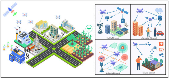
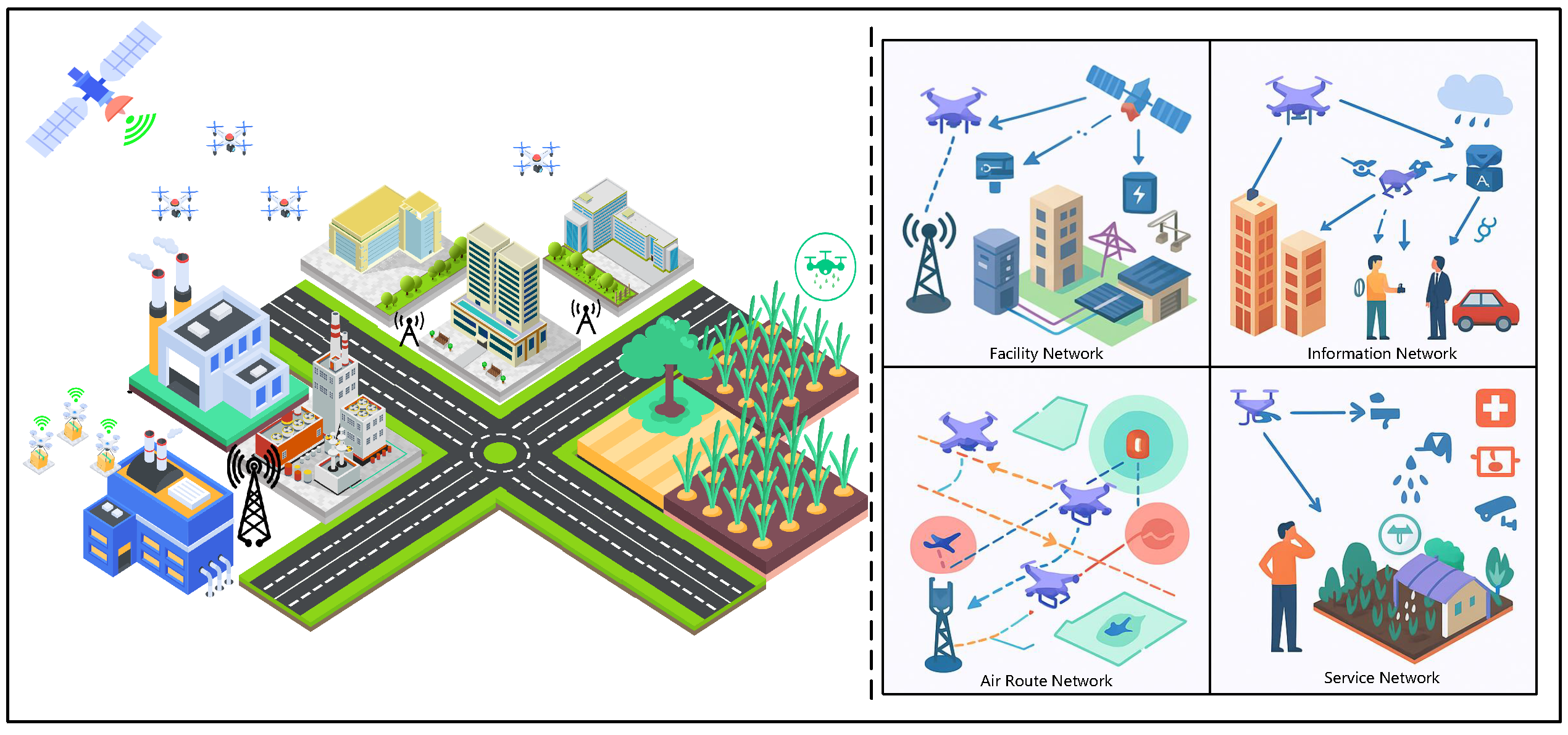
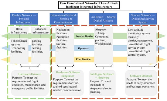
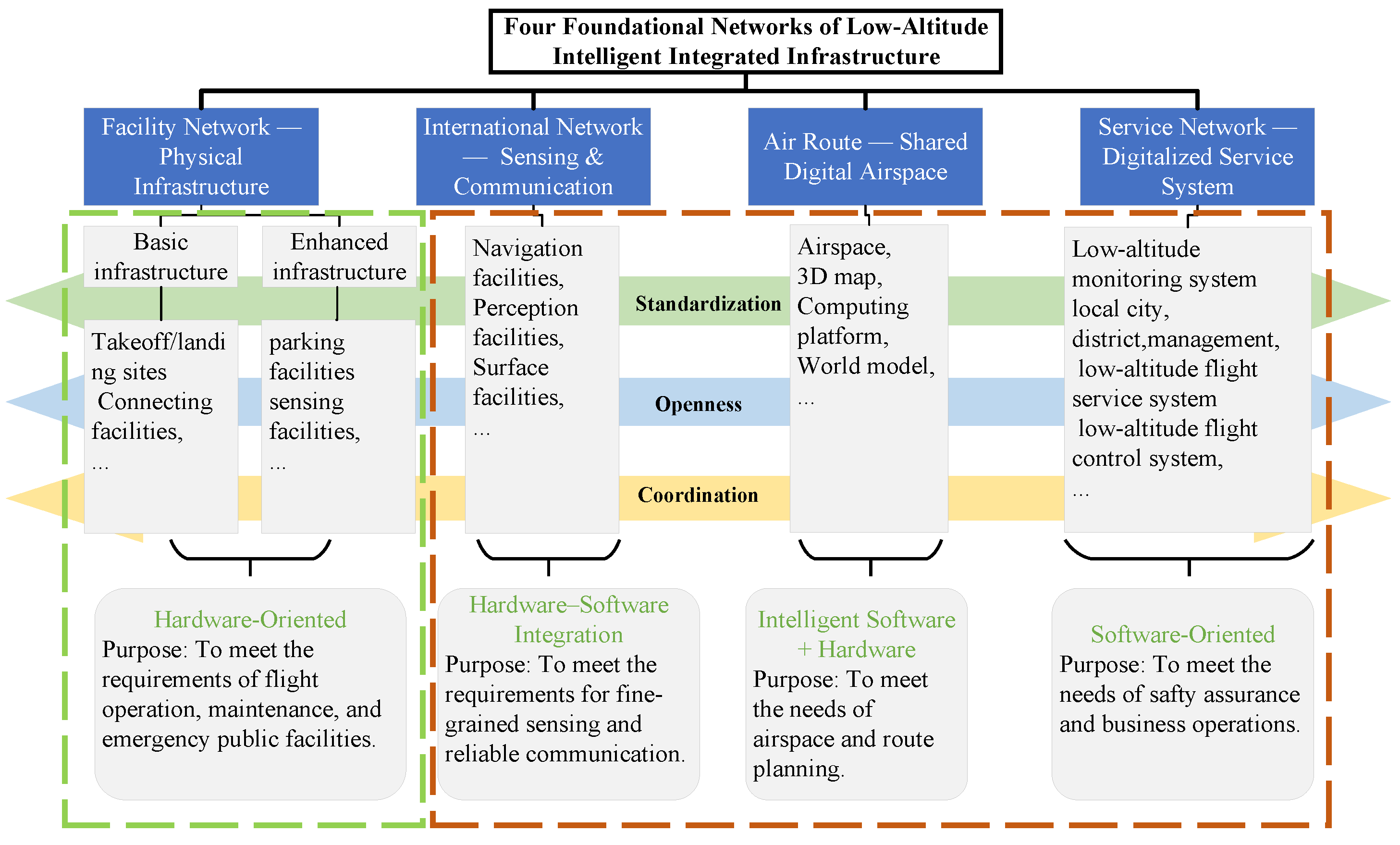
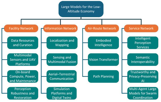
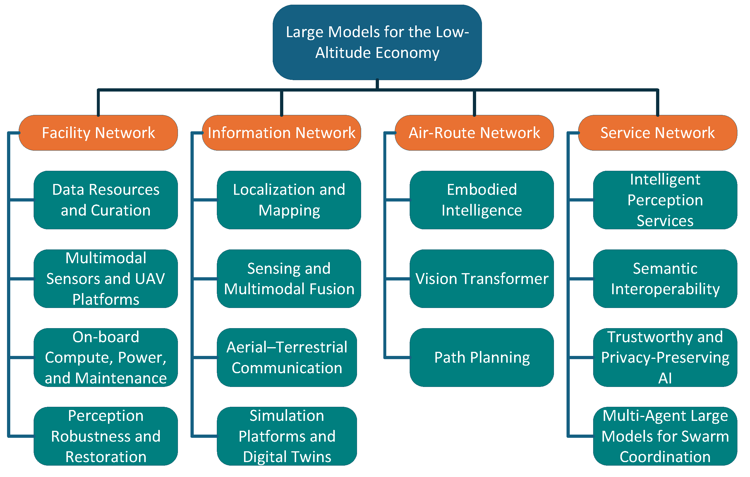

Disclaimer/Publisher’s Note: The statements, opinions and data contained in all publications are solely those of the individual author(s) and contributor(s) and not of MDPI and/or the editor(s). MDPI and/or the editor(s) disclaim responsibility for any injury to people or property resulting from any ideas, methods, instructions or products referred to in the content. |
© 2026 by the authors. Licensee MDPI, Basel, Switzerland. This article is an open access article distributed under the terms and conditions of the Creative Commons Attribution (CC BY) license.