Article

The Development of the Structural Heterogeneity of the Territory of a Large City as Conditions for the Formation of Urban Ecosystems on the Example of Kazan


by
Renat Zamaletdinov
1,
Regina Khamidullina
1,
Andrey Pichugin
2,
Peter Kornilov
2 and
Alexander Fayzulin
3,*
1
Department of Environmental Engineering and Water Resources Management, Kazan Federal University, 18 Kremlevskaya Street, Kazan 420008, Russia
2
Department of Public Administration, History, Sociology, Kazan National Research Technological University, 68 Karl Marx Street, Kazan 420015, Russia
3
Samara Federal Research Center of the Russian Academy of Sciences Institute of Ecology of Volga Basin Russian Academy of Sciences, Tolyatti 445003, Russia
*
Author to whom correspondence should be addressed.
Urban Sci. 2025, 9(9), 354; https://doi.org/10.3390/urbansci9090354
Submission received: 13 July 2025 / Revised: 18 August 2025 / Accepted: 29 August 2025 / Published: 4 September 2025
(This article belongs to the Special Issue Sustainable Urbanization, Regional Planning and Development)

Abstract

The article is devoted to the analysis of changes in the structure of the territory of Kazan in the period from the 18th century to the present. The spatial and temporal variability of the main functional zones of the city is considered. The main ways of expanding the territory of the city and its constituent functional zones related to the main historical processes are given. The total area of the city, according to cartographic analysis, increased 77.04 times in the period from 1739 to 2021. The article presents the dynamics of changes in the areas of the functional zones of the city during the period under review. The characteristic of ecosystems for the biodiversity of terrestrial vertebrates of the identified functional zones is given.

1. Introduction

Currently, a fairly rich material has been accumulated on the study of cities, which can serve as a subject of research for various scientific disciplines. The history of the formation of industrial cities and the problems associated with this specific development are usually discussed [1,2]. In some cases, we can talk about the peculiarities of the development of the construction system [2].
It is important to note that most of this kind of work is based mainly on the analysis of archival documents and literary sources. This approach makes it difficult to quantify the transformation of the natural environment of cities. The transformation of urbanized territories, being an important element of urban ecosystems, seems to be a necessary component of further urban development [3]. In this regard, it seems advisable to introduce into scientific circulation works devoted to environmental and historical aspects, the introduction of quantitative data related to the transformation of the urban environment. Despite the priority of the historical and humanitarian approach in studying this problem, natural sciences have made a significant contribution to the study of anthropogenic transformation of the urban environment [4,5].
Cities, despite their relatively small coverage area, are an important element of the landscape used as habitat for various species. Currently, much attention is being paid to the study of biotic components of ecosystems in urbanized areas [6,7]. The heterogeneity of urban ecosystems arises from a combination of natural and artificial landscape features [7]. The study of landscape heterogeneity is considered a promising area for assessing the dynamics and evolution of populations [8,9].
According to modern concepts, it is incorrect to consider urbanized territories as a homogeneous structure. On the one hand, we are talking about the presence of elements of the suburban landscape within the administrative boundaries of cities. On the other hand, we are talking about territories that differ in their genesis, topography, soil type, water content, and degree of anthropogenic transformation. Such a wide variety of habitat conditions for various species in urbanized territories allows us to consider them as a complex of specific ecosystems. These ecosystems are concentrated in a relatively small area [10].
In the literature devoted to the study of the specifics of urban ecosystems, various options for ranking the territory are used. All these options reflect one side or another of the process of developing the urban environment as a habitat for representatives of flora and fauna. The rating can be most clearly highlighted: (1) according to the principle of functional use of the territory; (2) according to the historical principle of expansion of the territory of the city. In the first case, we are talking about the specifics of the transformation of the natural environment, and, consequently, about a certain typology of ecosystems that can be located within a given territory [11]. A separate aspect of the issue is the procedure for ranking the city’s territory. We are talking not only about individual elements of the urban environment but also about their classification from the perspective of a conditional gradient in the intensity of anthropogenic transformation [11,12]. The issue of the functional use of individual sections of the urban area is most often considered. However, this approach, as a rule, does not take into account the historical aspect. This, in particular, is a mandatory element of ecological mapping [12]. Currently, a similar approach is used to assess the urbanization processes of large urban agglomerations [13,14]. The approach presented in the monograph by E.V. Karaseva et al. [15] lacks this disadvantage. The analysis of the mammalian fauna of Moscow was considered in this work through the prism of the historical development of the city territory. However, thus, it seems difficult to take into account the spatial heterogeneity of the urban environment. It seems more appropriate to take as a basis the fundamental processes of human society development when studying the spatial heterogeneity of the urban environment as a habitat for living organisms [16].
One of the most convenient approaches to solving such problems is the digitization of historical maps of cities with a ranking of the territory according to a certain principle. This is an integral part of ecological and geographical mapping [13]. The possibility of implementing this method is justified by the availability of historical maps for many cities [13,17].
A separate aspect of the issue is the procedure for ranking the city’s territory. This applies not only to individual elements of the urban environment but also to their classification from the perspective of a conditional gradient in the intensity of anthropogenic transformation [7,11,12]. The issue of the functional use of individual sections of the city is most often considered. This type of ranking is associated with thermal pollution of the city territory [17,18,19,20], the content of certain pollutants (for example, heavy metals) [21,22,23]. A special feature of this use is the connection between the transformation of the environment and the functional heterogeneity of the city with the specifics of the biotic components of urban ecosystems [12,24,25,26,27,28,29,30].
This article presents an ecological and historical analysis of the formation of spatial and functional heterogeneity of a large industrial city using the example of Kazan, with a description of the assessment of biodiversity, using the example of terrestrial vertebrates.

2. Materials and Methods

We were guided by the heterogeneity of the urban environment as a starting point. Thus, the city can rightfully be considered a complex of diverse ecosystems. In this regard, in order to understand the patterns of development of the urban environment, it is logical to introduce a system of ranking the territory according to some principle. The principle of the urbanization gradient is often used as a ranking system according to the literature devoted to the study of the characteristics of biotic components of urban ecosystems [11,12,23,25,26,27,28,29,30].
The principle of ranking involves dividing the city’s territory into sections based on the principle of the main type of functional use. We have identified the following functional zones on the territory of Kazan, on the basis of which we can conditionally divide the urbanization gradient:
  • Zone I. This area includes: an industrial area, a part of the city where the natural ecosystem has been completely destroyed. These territories may include not only industrial sites in the usual sense of the word but also territories such as garage buildings, old waste disposal sites and main transport routes.
  • Zone II. This is a zone of intense urbanization. These are mostly multi-storey buildings (more than two floors) in “residential” areas, including the central part of the city. This zone may include vacant lots, parks, hippopotamuses, embankments, soccer fields and sports fields, as well as parking lots near multi-storey buildings.
  • Zone III. This is a zone of moderate urbanization, built up mainly with one- and two-story buildings. These can be: vacant lots, parking lots near low-rise buildings. The main feature is the availability of garden plots.
  • Zone IV is the green zone of the city. This is a relatively undisturbed area, the closest to the natural one. It includes specially protected natural areas (protected areas), part of park areas but may also include undeveloped areas of the city, without woody vegetation (wastelands).
To a large extent, this type of ranking is similar to the taxonomic units of the urban landscape, which are proposed to be used to solve problems in the field of zoogeography [6]. In particular, this is true for the “City” system. Our analysis is based on a retrospective assessment of the dynamics of transformation of individual functional zones.
The research material for this article is the historical maps of Kazan [31,32,33], as well as historical sketches about Kazan and the Kazan province [34,35,36,37,38].
As research methods, we used: (1) overlay of historical maps and satellite images using the Qgis program; (2) compilation of maps with functional zoning using the Qgis program; (3) compilation of a historical description of the territory of the city change.
OSM 2021 standard maps were used as the basis for the formation of retrospective maps. The current boundaries of the municipality were formed on the initial map, and the final assessment of the areas of all functional zones was carried out. The creation of layers with the designation of functional zones was carried out by superimposing maps on a modern satellite image by marking calibration points on the original map. The latter have the same coordinates on all used maps. We mainly used intersections of roads, some historical buildings, etc., as such points. The points were mapped using coordinates that are entered manually for the calibration points. For each analyzed map, 10 points were selected for each map for a more reliable binding of the bitmap image.
This paper presents schemes of functional zoning of the territory of the city of Kazan using calibration points based on historical and cultural sites. The old central streets of the city, which originated in the 18th century, as well as the territories of squares, temples, monasteries, and the territory of the Kazan Kremlin were chosen as the main landmarks. The use of historical streets as calibration points is due to their stability and importance in shaping the urban planning structure of Kazan. These streets served as the core of the city’s development and remain relevant as landmarks for defining the boundaries of various functional zones. The technique included the collection of geospatial data using GIS technologies, where these objects served as control points for calibration of cartographic layers. This approach has made it possible to increase the accuracy of defining the boundaries of functional zones, taking into account the historical dynamics of the city’s development. In the process of registering maps of Kazan from different eras with significant differences in quality, several main difficulties arose related to the features of the source data and their characteristics. Many historical maps had low resolution, were made manually or were based on outdated mapping methods, which led to discrepancies in scale and detail. To solve this problem, we used geolocation and automatic correction methods using modern GIS technologies, which allowed us to scale and align maps, also increasing the accuracy of alignment. The general approach was to use an integrated geolocation system based on reliable control points, as well as automated data processing methods to minimize errors when combining maps of different eras. This method made it possible to achieve high accuracy of registration and provide an opportunity for a comparative analysis of urban development changes in Kazan over time.
In the course of this work, maps for 2021, 2003, 1988 and 1966, 1946, 1910, 1887, 1850, 1796, 1739.

3. Results

3.1. Functional Zoning of the Territory of Kazan in the 18th and 19th Centuries

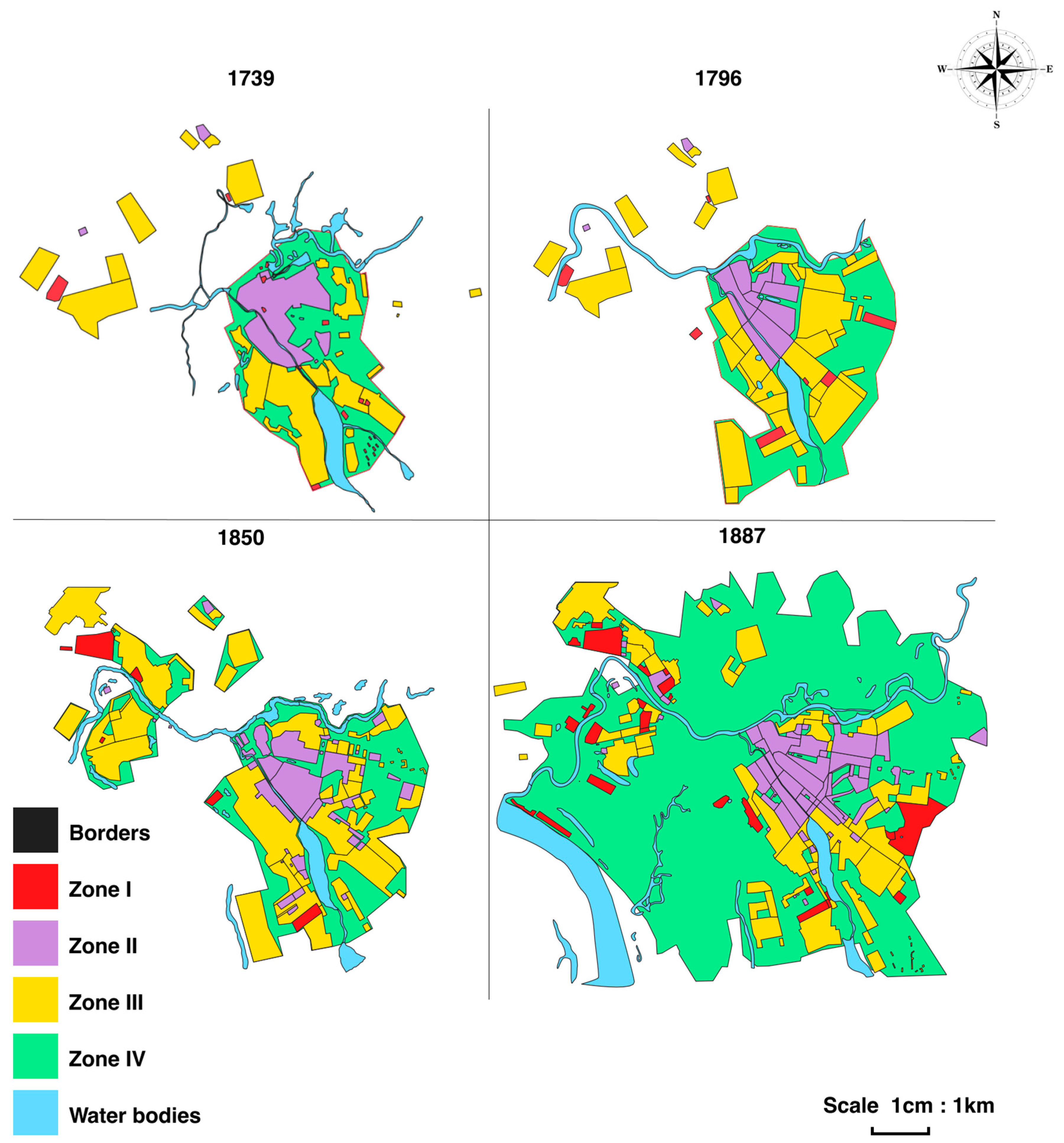
The scheme of functional zoning of the city’s territory in the XVIIIth century is shown in Figure 1. The total area of the city of Kazan in 1730 was 8.26 km2, of which: zone I was about 0.07 km2, zone II—1.54 km2, zone III—2.50 km2 and zone IV—4.14 km2. The total area of the city of Kazan in 1796 was 14.68 km2, of which: zone I was about 0.30 km2, zone II—1.63 km2, zone III—6.08 km2 and zone IV—6.68 km2.
The total area of the city of Kazan in 1850 was 20.36 km2, of which: zone I was about 0.54 km2, zone II—3.65 km2, zone III—8.06 km2 and zone IV—8.11 km2. The total area of the city of Kazan in 1887 was 52.05 km2, of which the area of zone I was about 1.96 km2, zone II—4.08 km2, zone III—8.11 km2 and zone IV—37.90 km2. The scheme of functional zoning of the city territory in the 19th century is shown in Figure 1.

3.2. Functional Zoning of the Territory of Kazan in the XX Century

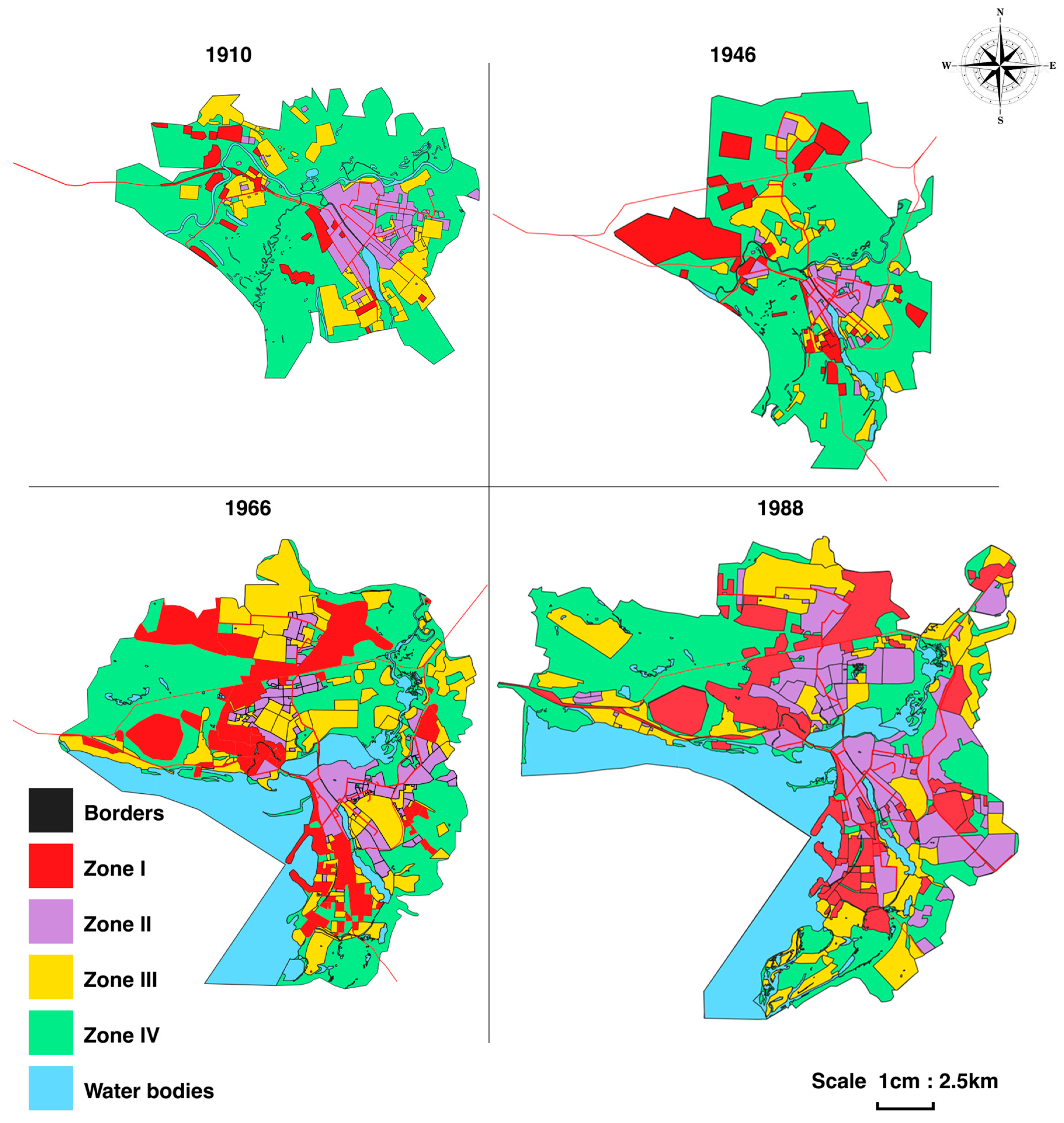
The scheme of functional zoning of the city territory in the 20th century is shown in Figure 2.
The total area of the city of Kazan in 1910 was 59.53 km2, of which: zone I was about 3.17 km2, zone II—6.71 km2, zone III—8.82 km2 and zone IV—40.84 km2. The total area of the city of Kazan in 1946 was 162.38 km2, of which: zone I was about 24.26 km2, zone II—10.00 km2, zone III—17.74 km2 and zone IV—103.39 km2. The total area of the city of Kazan in 1966 was 222.7 km2, of which: zone I was about 47.61 km2, zone II—24.22 km2, zone III—56.89 km2 and zone IV—99.09 km2. The total area of Kazan at the end of the last century (1988) was 268.56 km2, of which: zone I was about 59.73 km2, zone II—60.14 km2, zone III—58.58 km2 and zone IV—103.39 km2.

3.3. Functional Zoning of the Territory of Kazan in the 21st Century

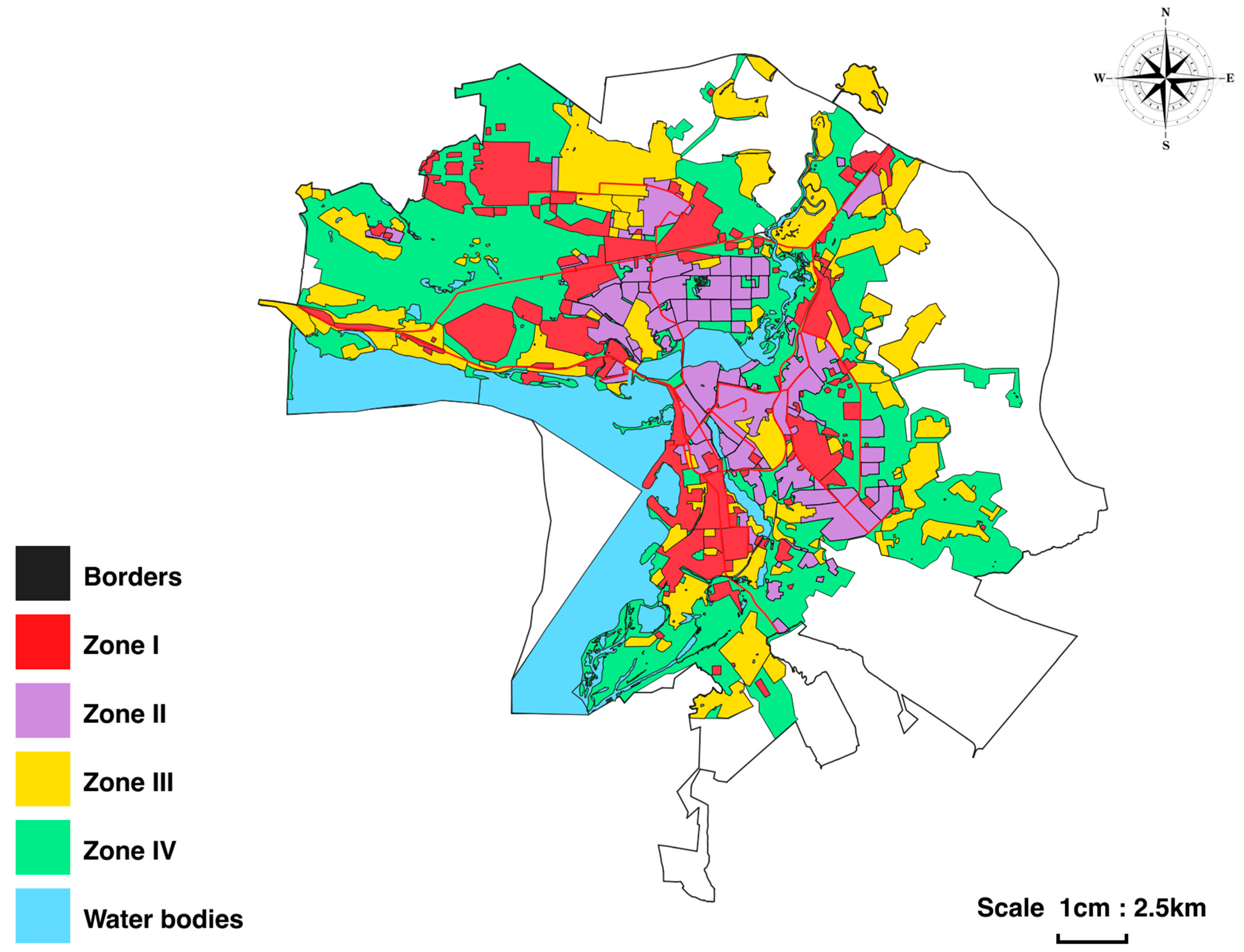
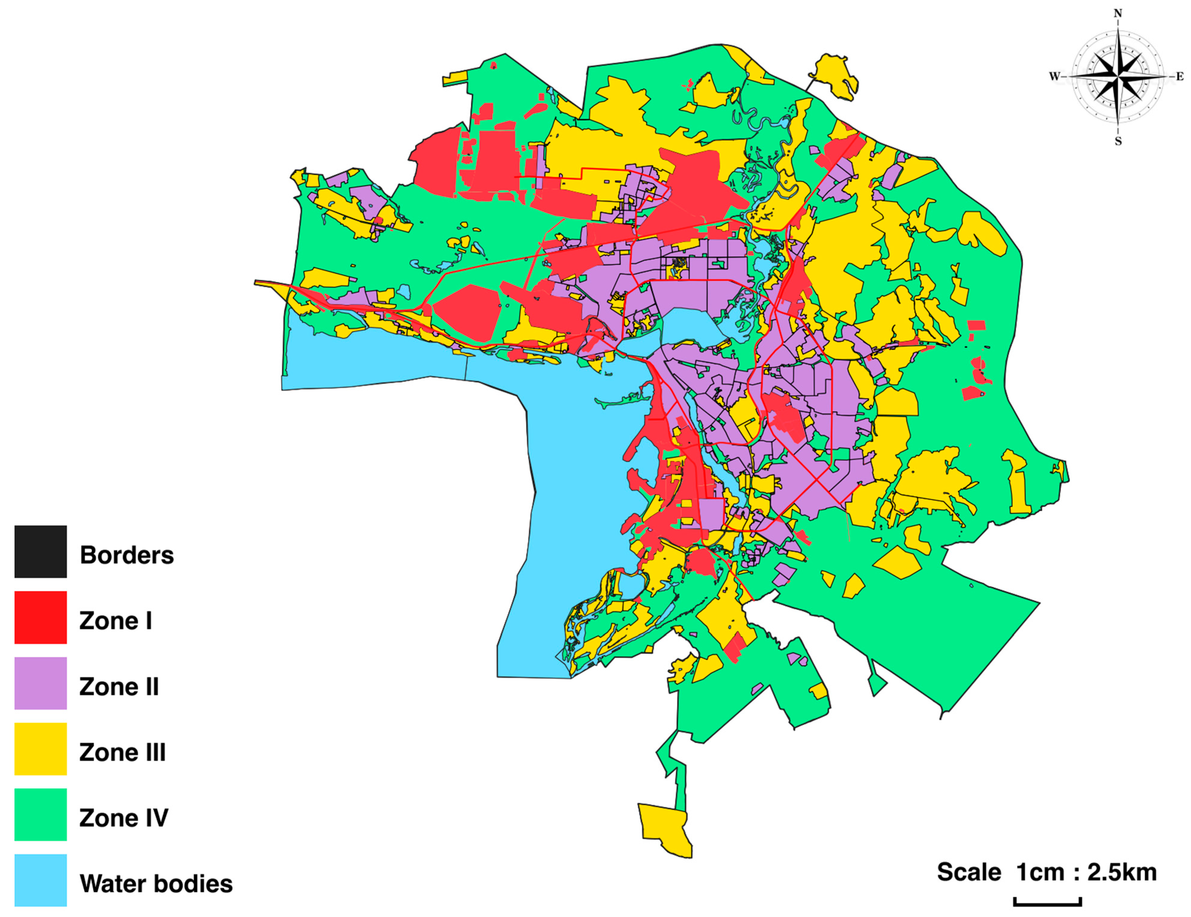
The scheme of functional zoning of the city’s territory in the 21st century is shown in Figure 3 and Figure 4. The total area of the city of Kazan in 2003 was 363.14 km2, of which: zone I was about 61.87 km2, zone II—65.35 km2, zone III—90.62 km2 and zone IV—154.62 km2. The total area of the city of Kazan is currently 539.48 km2, of which: zone I was about 72.94 km2, zone II—88.57 km2, zone III—140.60 km2 and zone IV—237.37 km2.

3.4. Characteristics of Changing Types of Functional Zoning

Unlike other cities, the process of large-scale reconstruction of the central part of the city began in preparation for the 1000th anniversary of the city of Kazan. The street and road network, landmark buildings, the territory of the Kazan Kremlin with a stone wall and towers, as well as other structures, allow us to calculate the distances. Also, the creation of the Kuibyshev reservoir in 1957 changed the boundaries of water bodies, while this process was described in detail [34,35,36,37,38].
Thus, the following models of substitution and transformation of functional zones were noted in Kazan:
The development of an industrial city (since the second half of the nineteenth century, the industrial period). (1) the transition from green zones to an industrial zone: in some cases it is possible to cut down forests that are not forest districts (Zone IV → Zone I); the development of residential buildings in the city (since the 60s of the XXth century). (2) the transition from green areas to multi-storey residential: in some cases it is possible to cut down forests that are not forest districts (Zone IV → Zone II); the development of residential buildings in the city (since the 50s of the XX century); (3) transition from low-rise buildings to multi-storey buildings (Zone III → Zone II); the development of residential buildings in the city (since the 70s of the XX century); (4) transition from industrial to multi-storey buildings (Zone I → Zone II).

3.5. Characteristics of the Biodiversity of the Territory of Kazan According to Functional Zoning Data for Terrestrial Vertebrates

An analysis of the available data on the taxonomic composition and distribution of terrestrial vertebrates (Table 1 Additional Materials) shows the lowest diversity in industrial (Zone I) and residential high-rise buildings (Zone II), 83 and 80 species. In the conditions of the green zone (Zone IV) and low-rise buildings (Zone III), it reaches 141 and 157 species.
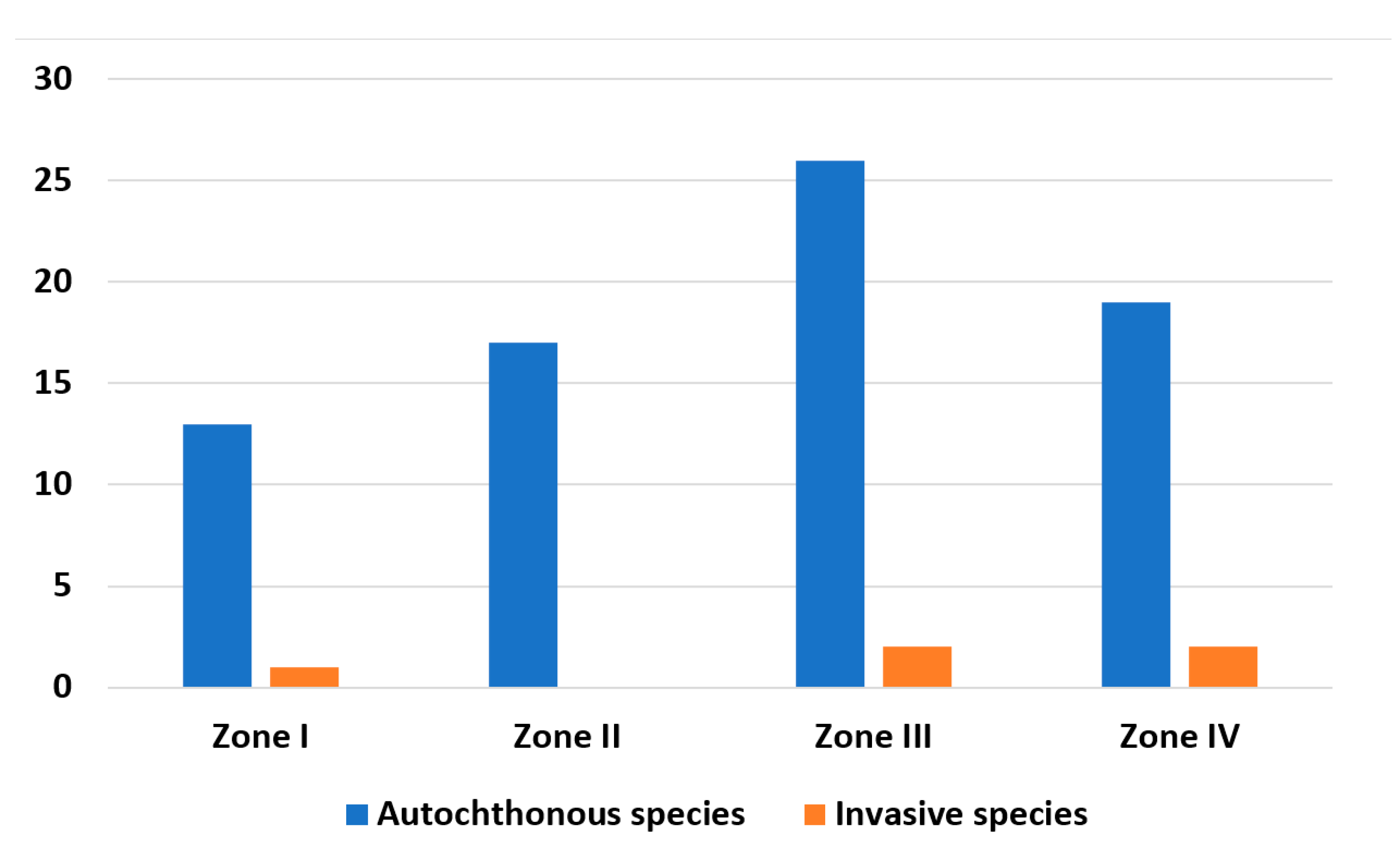
The fauna also includes invasive species of the American mink Neogale vison (Schreber, 1777) and the muskrat Ondatra zibethicus (Linnaeus, 1766) (Figure 5), which have a minor effect on the taxonomic composition of Kazan.

4. Discussion

In the first half of the 18th century, the city began to develop in the western and northern directions from the Kazanka River, and the territory of the modern Kirovsky district was developed. The boundaries of the city included Mokra and Yamskaya settlements in the west, Fedorovskaya and Podluzhnaya in the east. In the second half of the 18th century, the city began to expand its borders in the eastern, southern and south-western directions. It already included such settlements as the village of Arkhangelskoye, the village of Popovka, Tatarskaya, Mokraya, Yamskaya, Fedorovskaya, Kirpichnaya, Krasnaya and Podluzhnaya settlements. Estates of the nobility with large outbuildings, warehouses and parks were built on the southeastern outskirts of the city (Arskoye Field) [35].
Zone I. By the 18th century, Kazan’s industry itself consisted mainly of separate manufactories. In 1718, the Kazan Admiralty was established on the territory of the village of Bishbalta, where shipbuilding work was already underway. The sawmills were transferred to the Admiralty [37].
With the arrival of Peter the Great in Kazan, the development of light industry began—in 1715, the building of the cloth manufactory was built here. A whole village was formed around the factory. Soon, residential buildings appeared in a meadow under the mountain, closer to Kaban Lake. In 1719, a leather factory was founded on the basis of a cloth factory. At the beginning of the 18th century, there were already small soap factories, brick sheds, mills and a glass factory.
The city’s industrial facilities were planned to be built in settlements around Lake Kaban. By 1770, about 25 soap factories already existed in Kazan. There were other enterprises: malting, brewing and kvass, shoe, fur, jewelry and pottery. Kazan’s industry in the late 18th and early 19th centuries was already a large–scale production combined with small-scale commodity production.
Zones II and III. The urban infrastructure outside the “stone town” consisted mainly of low-rise wooden houses with gardens and vegetable gardens. There were stone buildings on the territory of the Kazan Kremlin. Some wooden buildings located near the Kremlin were later rebuilt in stone [35].
The construction was chaotic and inconsistent, which began to lead to the formation of a network of confusing streets. All this led to the publication in 1763 of one of the first documents regulating the layout of the city. Gradually, the development of a regular city plan and its implementation began [38].
Numerous fires forced the city to rebuild, but, according to a previously approved plan, fires also affected Admiralteiskaya Sloboda. After the fire of 1742, the administrative building of the Kazan Admiralty was rebuilt in stone.
The development of the central part of the city largely corresponds to the multi-storey category. However, most of the city is built up mainly with single-storey buildings with private plots next to them.
Zone IV. This accounts for most of the city’s territory in the 18th century. In this case, we are talking about the outskirts of the city, which were subsequently built up.
In the first half of the 19th century, Kazan continued to grow, its population gradually increased and by 1839 amounted to about 50,000 people. The area of the city has also increased due to the annexation of the Admiralty and Kizichesky, Yagodnaya settlements, Komarovo, Igumnovo, Savinovo to the city. The Arsk field began to be actively built up.
At that time, Kazan was being rebuilt due to numerous fires, still adhering to a regular layout. The streets began to be paved with stone and wood. Also, due to the impassability in the spring and autumn periods, it was decided to build a dam in Admiralteiskaya Sloboda.
Due to severe fires, a significant part of the city center burned down, namely Gostiny Dvor, Voskresenskaya Street, Mostovaya Street. But five years later, the city was again built up with stone and wooden houses.
The second half of the 19th century. For Kazan, urban planning became crucial: wooden buildings were gradually replaced by stone ones, due to the practicality and durability of the latter. Wooden buildings still prevailed over stone ones for a while. The architecture of buildings in this period is marked by a small number of one or two floors. It should also be noted that the peasant reform undertaken by Alexander II in 1861 gave an impetus to the urbanization of both provincial small towns of the Russian Empire and large provincial cities, including Kazan.
Zone I. During this period, a large number of industrial enterprises opened in Kazan. One of them was the Kotelov brothers’ tannery, located in the Yagodnaya Sloboda of the Zarechye region. During this period, the cloth factory already employed about 1600 workers. By the middle of the 19th century, there were a total of more than 80 factories and manufacturing plants in Kazan [34].
By that time, 91 factory-type enterprises were operating in the city. Kazan’s industry grew, continuing to gain momentum, and by 1855 the first Kazan factory, the Krestovnikov brothers’ stearin candle factory, was opened. At the same time, the first large brewery was opened in Kazan, founded by Oscar Petzold (1867). The Alafuzov factory consisted of 30 different enterprises, workshops and studios; the Krestovnikov Brothers Factory, founded in 1880, had 1800 workers and about 100 buildings, including five factory buildings [38].
Zone II. The development of this area was limited to the central part of the city. The houses were mostly two-storied.
Zone III. Most of the built-up area of the city consisted of one-storey buildings. It is important to note that the inclusion of new settlements did not significantly contribute to the growth of the area of this zone.
Zone IV. The areas that were confined to this zone in the 19th century are localized mainly on the periphery. Some areas that were part of Zone IV in the 19th century are still included in it.
At the end of the 19th century, horse-drawn tram transport was launched in Kazan. In 1907, an electric tram began operating, replacing horse-drawn trams. This significantly accelerated the movement of Kazan residents around the city. At the beginning of the 20th century, Kazan included 11 settlements [35]. The city grew due to the addition of new territories.
An important aspect in the expansion of the city’s territory as a factor of anthropogenic transformation is the increase in population. During the 20th century, the urban population in Kazan grew unevenly [39].
Stage 1, 1900–1917. Since the 20th century, the population of Kazan has been quite diverse, both in terms of nationality, social status and religion, numbering 129.9 thousand inhabitants.
Stage 2, 1917–1922. The events of 1917 and the Civil War reduced the population of the city. According to the 1920 census, the population of Kazan decreased by 60 thousand people (29%) and amounted to 146,495 inhabitants.
Stage 3, 1922–1945. The population of the city in 1939 was already 398 thousand inhabitants. By 1940, 5 administrative districts were formed in Kazan-Leoninsky, Stalinsky, Molotov, Baumansky and Kirovsky. Each of them, except for Baumansky, had villages and settlements.
Stage 4, 1945–1970. Kazan had 667.2 thousand inhabitants.
Stage 5, 1970–1990. In 1979, the city’s population reached one million people.
Stage 6, 1990–1998. There is a slight decrease in the number of the population. As of January 1, 1998, 1,078,100 people lived in Kazan.
Stage 7, 1999–2008. Kazan is divided into 7 administrative districts—Aviastroitelny, Vakhitovsky, Kirovsky, Moskovsky, Novo-Savinovsky, Privolzhsky and Sovetsky. The population is 1 million 116 thousand people. In the future, the trend towards an increase in the population of Kazan remains stable.
In the late 1930s, rapid industrial growth began in the Soviet Union. During this period, large industrial enterprises were built in Kazan, such as the thermal power plant-1 (CHP-1), a bakery, a brick factory, a fur factory and many others. This led to an increase in the population and, consequently, to an increase in the built-up area and the city as a whole. During this period, the city developed simultaneously in the southern and northern directions. The city was divided into districts, and by 1940 five administrative districts were formed: Stalinsky, Leninsky, Kirovsky, Molotov and Bauman. As a result of the transfer of enterprises to Kazan during the war, the city’s population almost doubled. After the end of the Great Patriotic War, a significant part of the evacuated specialists remained in Kazan, which led to an additional increase in the population [40]. So, in 1939, 406,000 people lived in Kazan. By the spring of 1942, this figure had grown to 515,000 and by 1956 to 565,000 people. All this led to an increase in the area of the old territories and the emergence of new neighborhoods: Aviastroitelny, Derbyshki and Sovetsky. In the 1950s, the Privolzhsky district (formerly called Stalinsky) turned into a large industrial area. During this period, plants such as Teplokontrol, Synthetic Rubber, Rubber Products, a medical instrument factory, a precision engineering plant, and many others were built [36]. By the early 1980s, Kazan’s population had grown to almost 1 million people [36]. Population growth determined the pace of development of the city. Areas such as the Zarechye, Azino and Gorki neighborhoods began to be built up. The current Novo-Savinovsky district was actively built up with houses of 9 or more floors. The city center was densely built up with multi-storey buildings. The organic synthesis plant was expanding. Kazanskaya TPP-3 and the TPP of the Kazan Automobile Complex were expanded and put into operation [41,42,43]. In the mid-70s of the last century, some enterprises were moved from the central part of the city, such as a sewing factory from Bauman Street, a foundry, workshops of Tatmebel and Metallovizdeliya companies, and many other enterprises [43]. A project for the construction of high-speed highways has been developed. High-speed ring highway, two high-speed diameters. Also in the mid-70s, a project was developed for the construction of the current Yamashev Avenue. Preparations for the construction of the Kazan Metro have begun.
Zone I. The beginning of the last century was characterized not only by the development of industrial enterprises but also by the formation of transport communications. In particular, we are talking about the beginning of a tram service. During the first five-year plans, such large industrial enterprises as CHP-1, a bakery, a brick factory, a fur factory and many others were built in Kazan. This led to an increase in the population and, consequently, to an increase in the area of construction and the total area of the city as a whole. Kazan has become one of the largest industrial cities in the Volga region [1,2].
A significant industrial upsurge occurred during the Great Patriotic War, when various enterprises were evacuated to Kazan. As a result, the traditional industrial areas of the city were replenished with new ones, which were located mainly on the outskirts. An important aspect in the formation of zone I was the construction of the Kazan River Port. This project was implemented as a result of filling the bottom of the Kuibyshev reservoir in 1955–1957. In the 1960s, Kazan’s largest petrochemical enterprise, Kazanorgsintez, was put into operation on the northwestern outskirts of the city. Currently, this enterprise remains the leading industrial center of Kazan. By the end of the century (starting in the 1990s), there was a gradual deindustrialization, which resulted in the cessation of industrial enterprises. This trend continues to this day.
Zone II. At the beginning of the century, this area was mainly limited to the central part of the city. By the middle of the century, such buildings began to spread to the outskirts of the city. The latter circumstance is related to the evacuation of a significant number of enterprises to Kazan. Residential quarters have begun to be built to accommodate the employees of these enterprises.
In the 1960s and 1970s, there was massive construction of residential areas. As a result of large-scale construction programs, by the end of the century, areas located in Zarechye, on the southern, eastern and southeastern outskirts of the city began to be built up. The area of wastelands was decreasing, and, in some cases (in particular, in the territory of the current Novo-Savinovsky district), construction was underway on the site of wetlands. The end of the last century (the second half of the 90s) was characterized by the beginning of the development of the territory of the Sovetsky district (Azino 1, 2, 3 microdistricts) as part of a program to eliminate dilapidated housing. Residents who had previously lived in the central districts of the city moved here, as well as to new buildings in the Novo-Savinovsky district. This trend continued until the beginning of this century.
Zone III. At the beginning of the century, most of the built-up area of the city was occupied by single-storey buildings. Since the mid-50s, in connection with the creation of the Kuibyshev reservoir, the development of the southeastern districts of the city began, where residents of the flooded areas were resettled. Significant growth of zone III occurred due to the annexation of new territories (the annexed settlements were built up mainly with single-storey buildings with garden plots). The formation of gardening associations in the second half of the century made a definite contribution to the development of this zone. Many of them still perform their original function.
Zone IV. By the middle of the last century, the relative area of Zone IV began to gradually decrease due to massive construction. By the end of the century, almost all urban protected areas were localized within this zone. Currently, most of it is occupied by the urban forest park “Lebyazhye”. Along with the main territory, it has a number of districts distributed among other administrative districts of the city.
The current stage of Kazan’s development is characterized by a number of features. Firstly, there is a gradual increase in the area of the city due to the incorporation of new districts. This applies not only to settlements but also to the inclusion of suburban agricultural land in the city. Secondly, consistent deindustrialization continues and not only because of the cessation of production. In this case, we are also talking about their gradual relocation. Thirdly, large-scale construction (mainly by multi-storey residential complexes) of previously undeveloped territories is taking place.
In the period from 2000–2005, the Kazan Metro was built for the millennium of the city, the Millennium Bridge across the Kazanka River was built, connecting Vish Nevsky Street and Amirkhan Avenue, as well as a number of other facilities [44,45].
Zone I. In the current century, the area of Zone I is gradually increasing due to the formation of new transport communications. The most striking example is the construction of the subway.
The functioning of industrial enterprises has significantly decreased. Large areas in Zone I are occupied by various storage facilities and auxiliary facilities.
Zone II. The area of zone II is significantly increased due to the construction of large-scale commercial housing with updated infrastructure. Currently, there is a consolidation of buildings, including previously developed areas.
In recent years, construction has been carried out on the territory that was previously occupied by industrial facilities—Zone I.
Zone III. A number of areas that previously belonged to Zone III are currently being actively built up with residential complexes. However, there is a significant increase in area within this zone. There are two main reasons for this phenomenon. First, we are talking about the annexation of suburban settlements to the city. Secondly, cottage settlements are being built on the outskirts (mainly in the northern and southern parts of the city).
Zone IV. Currently, there is a slight increase in the area of Zone IV due to the addition of new districts to the city. In general, there is a decrease in the relative share of this zone within the administrative boundaries.
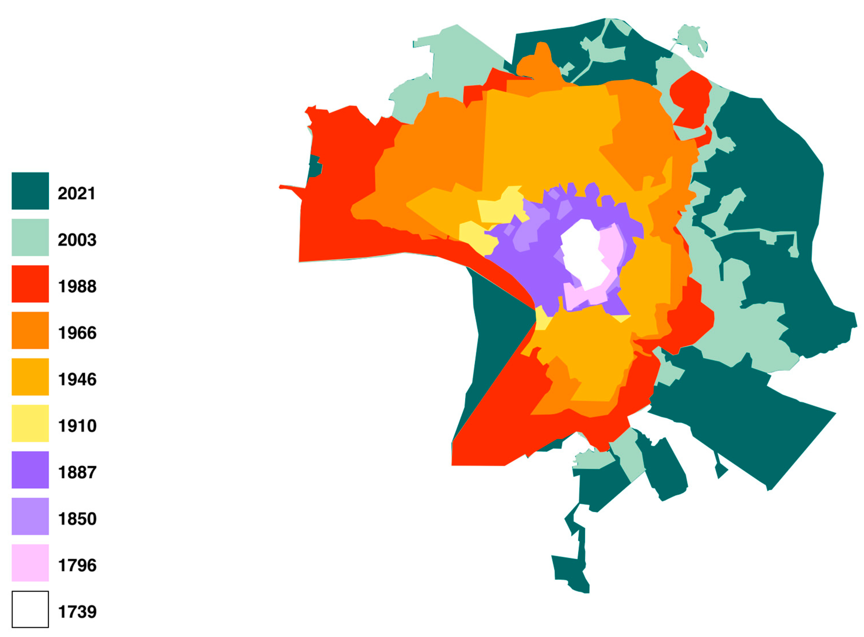
Based on the satellite images and historical maps we analyzed, we obtained a map of the boundaries of the city of Kazan for various time periods (Figure 6).
Due to the fact that the old maps were compiled at different times and according to different standards, the data we obtained has its inaccuracies due to the discrepancy in scale and, as a result, the complexity of the raster binding.
Thus, based on the analyzed data, we can clearly trace the change in the development of the urban area over the past 300 years. In the course of our work, we analyzed materials from different historical periods, thanks to which the functional zoning of Kazan was determined.
Along with this, the functional zones of the city and their area were identified. The area of each of the functional zoning elements, in turn, was converted into a percentage for further analysis (Table 2).
Based on the tables and maps obtained, we can see that, during the period of time that we studied, the area of Kazan has increased many times. Since 1739, when the area of the city was only 8.26 km2, and up to the present, 636.34 km2, the city has increased 77.04 times. Along with this, the functional zones of the city and their area were identified. The area of each of the functional zoning elements, in turn, was converted into a percentage for further analysis (Table 2).
The data obtained noted the dependence of biodiversity in terms of the number of species for different functional zoning territories of Kazan [26,46,47]. Similar changes were noted for various groups of vertebrates, for example, amphibians, and for other large cities in the European part of Russia: Yekaterinburg [12,24,25], Surgut [48], Ufa [47,49], Samara and Tolyatti [47,50], as well as Moscow [51], Perm, Nizhny Novgorod, Saransk, Ulyanovsk, Saratov and Penza [47]. The influence of other factors, for example, a high proportion of morphological anomalies, was noted for the large cities of Yekaterinburg [12,24] and Kazan [26] but is not manifested in other urbanized territories [52]. There is little published data for reptiles, while it is noted that, with the increasing urbanization of the territory, the number of agile lizards increases and the index of species diversity decreases for Moscow [51], Kazan [53], as well as for the cities of Ulyanovsk, Tolyatti and Samara [54]. The distribution of birds usually has a more complex structure but is generally determined by the presence of nesting sites and a food supply [55], which is characterized in zones 3 and 4. The noted decrease in diversity with an increase in the degree of urbanization of Kazan is consistent with the published data for Yekaterinburg [56] and Tyumen [57]. In general, it has been established that the area of green spaces, for example, parks within the city and suburbs, is a factor determining the level of biodiversity [58]. Thus, it confirms the need to analyze the zoning of urban areas, according to the degree and type of urbanization.
In the study area, for the Volga River basin, including urban areas, the assessment of ecosystem services is carried out according to the following parameters: (1) recreational load—the distribution of vacationers by recreation areas and nature of outdoor activities; (2) the area of forests and green spaces; (3) the recreational potential of health-improving areas and resorts; (4) the proportion of specially protected natural areas (protected areas) [59,60]. Taking this approach into account, the reduction in green spaces (Zona IV) of their development and the change in functional zoning will lead to a reduction in the basis for calculating ecosystem services. Also, the established decrease in biodiversity associated with the reduction in suitable habitats, their fragmentation, factors of concern and pollution of ecosystems also serves to assess ecosystem services [61]. Taking into account the available data, the trend of decreasing the estimated cost of ecosystem services with a change in functional zoning will continue in the conditions of Kazan. A change in the trend requires a change in urban planning policy, including the integration of forest and floodplain, meadow ecosystems, and the preservation of the natural coastal strip while “upgrading” reservoirs.
By the beginning of the 20th century, Kazan was finally forming as a provincial center, as well as a large commercial and industrial city. According to the data of the First General Census of the Russian Empire in 1897, a number of villages and towns, as well as 11 settlements, were annexed to Kazan during the development [62]. The successful growth and development of the Russian Empire launched the process of urbanization, increased the importance and attractiveness of urban settlements, including an overall increase in the population and area of large cities [63]. The development of Kazan as an administrative, political, commercial, economic, cultural, and industrial center is leading to population growth. The development of industry was the main factor in both population growth due to the arrival of rural residents and the expansion of the urban area. In turn, the creation of new production facilities with all the necessary infrastructure leads to the expansion of the urban area. This was also led by the creation of appropriate work settlements, which also gradually involved the lands on which they were located in urban processes. Kazan also emerged as a commercial, educational, multicultural and religious center of the Volga region [63]. It should be noted that natural factors limited the development of the city, such as the flood of the Volga River, until the creation of the Kuibyshev reservoir in 1957, when hills remained suitable for development, and the terrain itself was also very uneven with numerous potholes, ravines, and hills [63]. By 1910, the condition of the green areas was in an extremely neglected state. Many trees were cut down, while other plantings and flowers were broken and torn out [64]. For recreational purposes, residents visited areas outside the traditional city limits. Thus, already at the beginning of the 20th century, the process of expanding the green zone of Kazan was underway due to the lack of gardens and parks inside the city due to the annexation of the external territory. In the middle and towards the end of the 20th century, these processes only intensified. Since the beginning of the XXI century, the processes of changing low-rise to multi-storey buildings, and later industrial to residential, have begun, which also influenced the transformation of eco-systems, including habitats of terrestrial vertebrates.
The further development of the territory of Kazan as a complex of ecosystems is largely based on the intensification of the transformation of urban landscapes in combination with the development of new ones [65]. This is a general trend for urbanized territories, especially for cities in the former USSR, where the following stages can be distinguished: the emergence of industry in the XVIII–XIXth centuries; the change in the social system and the years of the first five-year plans in the USSR; the relocation of industrial enterprises during the Great Patriotic War of 1941–1945; the growth of consumption and population since the middle of the last century; production shutdown and deindustrialization of a number of cities since the 1990s; active replacement of private buildings and industrial sites with new buildings [66].

5. Conclusions

The information obtained serves as the basis for calculating ecosystem services depending on the recreational load and visits to urban forests [60], the level of biological diversity [67], parameters (indicators) of the state of plant populations [68] and animals [69,70], the degree of recreational load [70], the area and accessibility of green spaces [71,72,73], the state of water bodies [74,75,76] and ecosystem transformation [65,77,78].
The constructed maps allow for a retrospective analysis of the flora [79] and fauna [29] of the city. In addition, based on maps, it is possible to assess the specifics of changes in the urban population in the foreseeable past. The next stage of research should focus on improved design and development of urban areas, taking into account the conservation of urban forests and biodiversity [7], the impact of invasive species [80,81], and the assessment and maintenance of a high level of availability of ecosystem services [82,83,84,85,86].

Author Contributions

Conceptualization, R.Z., A.P. and A.F.; methodology, R.Z., R.K. and A.F.; software, R.K.; validation, R.Z., A.P. and P.K.; formal analysis, R.Z., A.P. and P.K.; resources, R.Z.; data curation, R.Z., A.P. and P.K.; writing—original draft preparation, R.Z.; writing—review and editing, R.Z. and A.F.; visualization, R.K.; supervision, R.Z.; project administration, R.Z. and A.F. All authors have read and agreed to the published version of the manuscript.

Funding

This research was performed within the framework and the research topic of the Institute of Ecology of the Volga River Basin, a branch of the Samara Federal Research Center of the Russian Academy of Sciences No. 1023062000002-6-1.6.20;1.6.19 “Land vertebrates of the Middle Volga region and adjacent territories and their parasitic worms: ecological, faunal and biological aspects of the organization and functioning of communities against the background of natural and anthropogenic changes”.

Data Availability Statement

Data is contained within the article.

Acknowledgments

The authors express their sincere gratitude to A.M. Kalimullin, R.R. Mingaliyev, Z.R. Yuzmukhametova, I.I. Rakhimov, A.M. Basyirov, A.N. Belyaev, I.Z. Khairutdinov, A.F. Bespalov, I.S. Shigapov and D.N Vavilov (Kazan) for consultations on individual issues and for valuable comments during the preparation of the manuscript.

Conflicts of Interest

The authors declare no conflicts of interest.

References

  1. Kalimullin, A.M. The Historical and Ecological Analysis of Middle Volga Industrial Development in Russia in the Second Half of the XXth Century. Rev. Eur. Stud. 2015, 7, 172–177. [Google Scholar] [CrossRef]
  2. Kalimullin, A.M.; Vinogradov, A.V. Ecological and Sanitary Problems of Kazan Province Industrial Development in the XIXth and Early XXth Centuries. Rev. Eur. Stud. 2015, 7, 188–194. [Google Scholar] [CrossRef]
  3. Bolshakova, O.V. Ecological History of the Russian Empire and the Soviet Union: Modern Foreign Research: Analytical Review; RAS INION, Center for Russian Studies: Moscow, Russia, 2024; p. 106. (In Russian) [Google Scholar]
  4. Ptichnikova, G.A. A comprehensive view on the evolution of urban spatial structure of the largest post-soviet cities in Russia. In Proceedings of the XXV ISUF International Conference “Urban Form and Social Context: From Traditions to Newest Demands”, Krasnoyarsk, Russia, 5–9 July 2018; Kukina, I., Fedchenko, I., Chui, I., Eds.; Publishing House Siberian Federal University: Krasnoyarsk, Russia, 2019; pp. 206–214. [Google Scholar]
  5. Pivovarov, Y.L. Fundamentals of Geourbanistics: Urbanization and Urban Systems: Textbook for Students of Higher Educational Institutions; VLADOS: Moscow, Russia, 1999; p. 232. (In Russian) [Google Scholar]
  6. Tishchenkov, A.A. On the classification of the urbanized landscape in relation to zoogeographical purposes. Volga Reg. Ecol. J. 2006, 1, 95–102. (In Russian) [Google Scholar]
  7. Barua, M.; Sinha, A. Animating the urban: An ethological and geographical conversation. Soc. Cult. Geogr. 2017, 20, 1160–1180. [Google Scholar] [CrossRef]
  8. Band, L.E.; Cadenasso, M.L.; Grimmond, C.S.; Grove, J.M.; Pickett, S.T.A. Heterogeneity in urban ecosystems: Patterns and process. In Ecosystem Function in Heterogeneous Landscapes; Lovett, G.M., Turner, M.G., Jones, C.G., Weathers, K.C., Eds.; Springer: New York, NY, USA, 2005; pp. 257–278. [Google Scholar]
  9. Fahrig, L.; Nuttle, W.K. Population Ecology in Spatially Heterogeneous Environments. In Ecosystem Function in Heterogeneous Landscapes; Lovett, G.M., Turner, M.G., Jones, C.G., Weathers, K.C., Eds.; Springer: New York, NY, USA, 2005; pp. 95–118. [Google Scholar]
  10. Sukopp, G.; Elvers, G.; Matthes, G. Zukopp; G. Study of the ecology of urbanized territories (using West Berlin as an example). Ecology 1981, 2, 15–20. (In Russian) [Google Scholar]
  11. Klausnitzer, B. Ecology of Urban Fauna: Translated from German. Moscow Mir Publishing House: Moscow, Russia, 1990; p. 246. (In Russian) [Google Scholar]
  12. Vershinin, V.L. Urban gradient and its long-term dynamics as a basis for effective control of amphibian populations. In Issues of Herpetology, Proceedings of the IV Congress of the A.M. Nikolsky Herpetological Society, Kazan, Russia, 12–17 October 2009; Russian Collection: St. Petersburg, Russia, 2011. (In Russian) [Google Scholar]
  13. Makarov, V.Z.; Novakovsky, B.A.; Chumachenko, A.N. Ecological and Geographical Mapping of Cities; Nauchnyy Mir: Moscow, Russia, 2002; p. 196. (In Russian) [Google Scholar]
  14. Wan, Z.; Chen, X.; Ju, M.; Ling, C.; Liu, G.; Liao, F.; Jia, Y.; Jiang, M. Reconstruction and Pattern Analysis of Historical Urbanization of Pre-Modern China in the 1910s Using Topographic Maps and the GIS-ESDA Model: A Case Study in Zhejiang Province, China. Sustainability 2020, 12, 537. [Google Scholar] [CrossRef]
  15. Karaseva, E.V.; Telitsyna, A.Y.; Samoilov, B.L. Mammals of Moscow in the Past and Present; Nauka: Moscow, Russia, 1999; p. 245. (In Russian) [Google Scholar]
  16. Breyfogle, N.B. Toward an environmental history of tsarist Russia and the Soviet Union. In Eurasian Environments: Nature and Ecology in Imperial Russian and Soviet History; University of Pittsburgh Press: Pittsburgh, PA, USA, 2018; pp. 3–20. [Google Scholar]
  17. Xu, J.; Wang, J.; Xiong, N.; Chen, Y.; Sun, L.; Wang, Y.; An, L. Analysis of Ecological Blockage Pattern in Beijing Important Ecological Function Area, China. Remote Sens. 2022, 14, 1151. [Google Scholar] [CrossRef]
  18. Myagkov, M.S. Ecological consequences of mesoclimatic anomalies of the Moscow megacity. Ecol. Urban Areas 2006, 4, 28–34. (In Russian) [Google Scholar]
  19. Perevedentsev, Y.P.; Vereshchagin, M.A.; Naumov, E.P.; Shatalinsky, K.M. Climate of Kazan. In Ecology of the City of Kazan; Mingazova, N.M., Torsuev, N.P., Latypova, V.Z., Boyko, V.A., Eds.; Feng: Kazan, Russia, 2005; pp. 43–52. (In Russian) [Google Scholar]
  20. Perevedentsev, Y.P.; Vereshchagin, M.A.; Naumov, E.P.; Shatalinsky, K.M.; Shafikova, R.B. The Climate of Kazan and Its Changes in the Modern Period; Publishing House of Kazan State University: Kazan, Russia, 2006; p. 216. (In Russian) [Google Scholar]
  21. Pudovik, E.M. Fractal Analysis of Complex Ecological and Geographical Objects (Using Kazan as an Example). Ph.D. Thesis, Kazan State University, Kazan, Russia, 19 June 1997. (In Russian). [Google Scholar]
  22. Aleksandrova, A.B. Soil and Ecological Conditions of Landscape Formation in Kazan. Ph.D. Thesis, Kazan State University, Kazan, Russia, 4 October 2004. (In Russian). [Google Scholar]
  23. Fashutdinov, M.G. Formation and Dynamics of Geochemical Fields of Heavy Metals in a Large Industrial City. Ph.D. Thesis, Yaroslavl State Pedagogical University, Yaroslavl, Russia, 25 March 2004. (In Russian). [Google Scholar]
  24. Vershinin, V.L. Ecological Features of Amphibian Populations in Urbanized Territories. Ph.D. Thesis, Institute of Plant and Animal Ecology of the Ural Branch of the Russian Academy of Sciences, Ekaterinburg, Russia, 11 March 1997. (In Russian). [Google Scholar]
  25. Vershinin, V.L.; Vershinina, S.D.; Berzin, D.L.; Zmeeva, D.V.; Kinev, A.V. Long-term observation of amphibian populations inhabiting urban and forested areas in Yekaterinburg, Russia. Sci. Data 2015, 2, 150018. [Google Scholar] [CrossRef] [PubMed]
  26. Zamaletdinov, R.I. Ecology of Amphibians in a Big City (on Example of Kazan). Ph.D. Thesis, Kazan State University, Kazan, Russia, 4 November 2003. (In Russian). [Google Scholar]
  27. Hirtenfelder, C.T. An analytical framework to understand the problematization of urban (historical) animals. Environ. Plan. E Nat. Space 2024, 7, 2182–2203. [Google Scholar] [CrossRef]
  28. Arcari, P.; Probyn-Rapsey, F.; Singer, H. Where species don’t meet: Invisibilized animals, urban natureand city limits. Environ. Plan. E Nat. Space 2021, 4, 940–965. [Google Scholar] [CrossRef]
  29. Rakhimov, I.I.; Zamaletdinov, R.I.; Basyirov, A.M.; Belyaev, A.N.; Khairutdinov, I.Z.; Bespalov, A.F.; Nazarov, N.G.; Mingaliev, R.R.; Malev, A.V.; Mingazova, N.M.; et al. The Animal World of a Megalopolis on the Example of Kazan (Vertebrates); Foliant: Kazan, Russia, 2025; p. 248. (In Russian) [Google Scholar]
  30. Yanchurevich, O.V. Reproductive Biology and Structure of Amphibian Populations in an Urbanized Landscape. Ph.D. Thesis, Institute of Zoology of the NAS of Belarus, Minsk, Belarussia, 6 June 2006. (In Russian). [Google Scholar]
  31. Kazan Cartographer. Maps of Tatarstan, the Volga Region, the Urals. Available online: http://tat-map.ru/ (accessed on 25 January 2021).
  32. Images of USSR Cities from American Reconnaissance Satellites. Available online: https://spymaps.space/ (accessed on 25 January 2021).
  33. Old City Maps. Available online: http://www.etomesto.ru/ (accessed on 25 January 2021).
  34. Ostroumov, V.P. Kazan: Essays on the History of the City and Its Architecture; Publishing House of Kazan State University: Kazan, Russia, 1978; p. 295. (In Russian) [Google Scholar]
  35. Abdullin, Y.A.; Alishev, S.K.; Gilmanov, Z.I.; Smykov, Y.I.; Khalikov, A.K.; Khasanov, K. (Eds.) History of Kazan: Book 1; Tatar Book Publishing House: Kazan, Russia, 1988; p. 352. (In Russian) [Google Scholar]
  36. Gilmanov, Z.I.; Zalyalov, A.M.; Mukharamov, M.K.; Nezipova, K.A. (Eds.) History of Kazan: Book 2; Tatar Book Publishing House: Kazan, Russia, 1991; p. 382. (In Russian) [Google Scholar]
  37. Pichugin, A.B. History of the Kazan Region Based on the Materials of Kapiton Milkovich, 1783–1804; KNRTU Publishing House: Kazan, Russia, 2021; 140p. (In Russian) [Google Scholar]
  38. Garzavina, A.V.; Novitsky, A.I. My Kazan: Historical, Architectural and Artistic Appearance; Tatar Book Publishing House: Kazan, Russia, 1984; p. 192. (In Russian) [Google Scholar]
  39. Kubyshkina, E.N. A System of Diagnostic Criteria and Indicators for the Geoecological Assessment of the Territory of Kazan. Ph.D. Thesis, Kazan State University, Kazan, Russia, 2008. (In Russian). [Google Scholar]
  40. Kalinin, N.F. Kazan: Historical Essay; Tatknigoizdat: Kazan, Russia, 1951; p. 322. (In Russian) [Google Scholar]
  41. Factories and Plants of all Russia. Information on 31,523 Factories and Plants; Publishing House of the Fish L.M. Association: Kiev, Russia, 1913; p. 1687. (In Russian) [Google Scholar]
  42. Khairutdinov, R.R. The authorities treated the problem of preserving the Bulgarian heritage with a certain skepticism. Gasyrlar Avazy Echo Centuries 2008, 2, 87–98. (In Russian) [Google Scholar]
  43. Mukharyamova, M.K. (Ed.) History of the Tatar ASSR; Tatknigoizdat: Kazan, Russia, 1980; p. 256. (In Russian) [Google Scholar]
  44. Gaisin, I.T.; Denmukhametov, R.R.; Zyablova, O.V. Republic of Tatarstan: Brief Geographical Handbook; Tatar Book Publishing House: Kazan, Russia, 2013; p. 133. (In Russian) [Google Scholar]
  45. Shamshadinova, S.M. Development of Kazan in the 20th century. In Proceedings of the Collection of Articles from the Final Scientific and Practical Conference, Kazan, Russia, 11–12 March 2010; Nogmanov, A.I., Valeev, R.M., Shaidullin, R.V., Eds.; Publishing House Institute of the Tatar Encyclopedia of the Academy of Sciences of the Republic of Tatarstan: Kazan, Russia, 2010; pp. 170–171. (In Russian). [Google Scholar]
  46. Zamaletdinov, R.I. Promising Directions for the Study of Adaptive Processes of Urban Populations. In Study of Living Systems in the Conditions of Anthropogenic Transformation of Natural Landscapes of the Republic of Tatarstan (for the 20th Anniversary of the Department of Bioecology, Hygiene and Public Health of the Institute of Fundamental Medicine and Biology of the Kazan Federal University); Olitekh: Kazan, Russia, 2022; pp. 75–80. (In Russian) [Google Scholar]
  47. Faizulin, A.I. Adaptive strategies and assessment of tolerance to anthropogenic impacts on the territory of the Volga River Basin. In Mate-Rials of the Fourth Russian-Polish School of Young Ecologists “Types of Strategy and Not Only…”, Tolyatti, Russia, 6–12 September 2010; Rozenberg, G.S., Ed.; Kassandra: Tolyatti, Russia, 2010; pp. 11–14. [Google Scholar]
  48. Ibragimova, D.V. Amphibians in the Ecosystems of the City of Surgut. Ph.D. Thesis, Novosibirsk State Agrarian University, Novosibirsk, Russia, 16 May 2013. (In Russian). [Google Scholar]
  49. Kuzovenko, A.E. Ecological and Faunistic Characteristics of Amphibians in Urbanized Areas of the Samara Region. Ph.D. Thesis, Institute of Ecology of the Volga Basin of the RAS, Tolyatti, Russia, 11 May 2018. (In Russian). [Google Scholar]
  50. Zaripova, F.F. Ecological and Faunistic Characteristics of Amphibious Urban Territories of the Republic of Bashkortostan. Ph.D. Thesis, Institute of Ecology of the Volga River Basin RAS, Togliatti, Russia, 2012; p. 209. (In Russian). [Google Scholar]
  51. Bobrov, V.V.; Semenov, D.V. Amphibians and Reptiles of Moscow and Moscow Province: Modern status and conservation. Bull. Tambov State Univ. Ser. Nat. Tech. Sci. 2013, 18, 2984–2987. (In Russian) [Google Scholar]
  52. Fayzulin, A.I.; Chihlyaev, I.V.; Mineev, A.K.; Kuzovenko, A.E.; Mihaylov, R.A.; Zaripova, F.F.; Popov, A.I.; Ermakov, O.A. New Data on the Anomalies of Tailless Amphibians of the Volga Basin. KnE Life Sci. 2018, 4, 29–35. [Google Scholar] [CrossRef]
  53. Khayrutdinov, I.Z. The Abstract of the Dissertation Candidate Biological Sciences (Kazan) Ecology of Reptiles of Urbanized Territories: (on the Example of Kazan). Ph.D. Thesis, Kazan State University, Kazan, Russia, 10 June 2010. (In Russian). [Google Scholar]
  54. Bakiev, A.G.; Fayzulin, A.I.; Krivosheev, V.A.; Eplanova, G.V.; Peskov, A.N. Amphibians and reptiles living in urban areas in the Samara and Ulyanovsk regions. Relev. Probl. Herpetol. Toxinol. 2003, 6, 3–9. (In Russian) [Google Scholar]
  55. Larionov, A.G.; Isaev, A.P.; Egorov, N.N. (Eds.) Birds of Russian Cities; KMC Publishing House: Moscow, Russia, 2012; p. 513. (In Russian) [Google Scholar]
  56. Chernousova, N.F. Effect of urbanization on communities of small mammals in park-forests in a large industrial center. Russ. J. Ecol. 1996, 27, 278–283. [Google Scholar]
  57. Gashev, S.N.; Mukanova, A.A.; Khalitov, I.Z. Effect of urbanization on mammal communities in the Tyumen region. Tyumen State Univ. Her. 1999, 3, 85–91. (In Russian) [Google Scholar]
  58. Cornelis, J.; Hermy, M. Biodiversity relationships in urban and suburban parks in Flanders. Landsc. Urban Plan. 2004, 69, 385–401. [Google Scholar] [CrossRef]
  59. Rozenberg, A.G. Ecosystem services and natural capital of the Volga river basin. In Proceedings of the Mate-Rials of the Fourth Russian-Polish School of Young Ecologists “Types of Strategy and NotOnly…”, Tolyatti, Russia, 6–12 September 2010; Rozenberg, G.S., Ed.; Kassandra: Tolyatti, Russia, 2010; pp. 46–47. [Google Scholar]
  60. Rozenberg, A.G. Estimation of ecosystem services for the territory of Samara region. Russ. J. Econ. Law 2012, 3, 145–150. (In Russian) [Google Scholar]
  61. Díaz, S.; Settele, J.; Brondízio, E.S.; Ngo, H.T.; Guèze, M.; Agard, J.; Arneth, A.; Balvanera, P.; Brauman, K.A.; Butchart, S.H.M.; et al. (Eds.) Summary for Policymakers of the Global Assessment Report on Biodiversity and Ecosystem Services of the Intergovernmental Science-Policy Platform on Biodiversity and Ecosystem Services; IPBES Secretariat: Bonn, Germany; p. 56. Available online: https://files.ipbes.net/ipbes-web-prod-public-files/inline/files/ipbes_global_assessment_report_summary_for_policymakers.pdf (accessed on 25 July 2025).
  62. Youth of an Ancient City; Tatar Book Publishing House: Kazan, Russia, 1978; p. 272. (In Russian)
  63. Mukhamadiev, A.G. History of the formation of Kazan and development of territories. In Ecology of the City of Kazan; Mingazova, N.M., Torsuev, N.P., Latypova, V.Z., Boyko, V.A., Eds.; Feng: Kazan, Russia, 2005; pp. 12–21. (In Russian) [Google Scholar]
  64. Novikova, M.P.; Yupina, G.A. Gardens and Parks of Kazan; Folio: Kazan, Russia, 2012; p. 127. (In Russian) [Google Scholar]
  65. The First General Population Census of the Russian Empire, 1897. Kazan Province. Supplement. 1904 (Cover 1903). XIV; p. 284. Available online: https://www.prlib.ru/en/node/436632 (accessed on 25 January 2025). (In Russian).
  66. Amirkhanova, M.R. Natural-geographical and urban development appearance of Kazan at the beginning of the 20th century. Echo Centuries 2007, 1–2. Available online: https://cyberleninka.ru/article/n/prirodno-geograficheskiy-i-gradostroitelnyy-oblik-kazani-v-nachale-xx-v (accessed on 5 May 2025). (In Russian).
  67. On the prohibition of picking flowers in city gardens, trampling grass, damaging trees, walking dogs, riding bicycles, etc. Resolution of the City Duma. Kazan Provincial Gazette, 1 May 1912. (In Russian)
  68. Okulova, S.M. Reproductive characteristics of urban plant populations (using legumes as an example). In Ecology of the City of Kazan; Mingazova, N.M., Torsuev, N.P., Latypova, V.Z., Boyko, V.A., Eds.; Feng: Kazan, Russia, 2005; pp. 171–176. (In Russian) [Google Scholar]
  69. Belyaev, A.N. Mammals of the city of Kazan. In Ecology of the City of Kazan; Mingazova, N.M., Torsuev, N.P., Latypova, V.Z., Boyko, V.A., Eds.; Feng: Kazan, Russia, 2005; pp. 213–224. (In Russian) [Google Scholar]
  70. Zamaletdinov, R.; Svinin, A.; Fayzulin, A.; Ermakov, O.; Mikhaylova, R.; Litvinchuk, S. Age Structure of Water Frogs of the Genus Pelophylax in the Middle Volga River Region (European Russia). Animals 2025, 15, 1273. [Google Scholar] [CrossRef] [PubMed]
  71. Yupina, G.A. Inventory of green spaces and problems of city greening. In Ecology of the City of Kazan; Mingazova, N.M., Torsuev, N.P., Latypova, V.Z., Boyko, V.A., Eds.; Feng: Kazan, Russia, 2005; pp. 158–171. (In Russian) [Google Scholar]
  72. Maphosa, S.N.; Nkosi, S.E.; Chabalala, Y. Impact of Urban Green Spaces on the Livelihoods of Residents in Bulawayo and Johannesburg Cities. Urban Sci. 2025, 9, 194. [Google Scholar] [CrossRef]
  73. Paredes Méndez, D.; Pérez-Sánchez, M.; Sánchez-Romero, F.J.; Coronado-Hernández, O.E. Assessment of the Effectiveness of Green Infrastructure Interventions to Enhance the Ecosystem Services in Developing Countries. Urban Sci. 2025, 9, 85. [Google Scholar] [CrossRef]
  74. Derevenskaia, O.Y. Zooplankton of Lakes of the Middle Volga Region Under the Influence of Natural and Anthropogenic Factors; Kazan University: Kazan, Russia, 2024; p. 272. (In Russian) [Google Scholar]
  75. Atakhanova, Z.; Baigaliyeva, M. Kazakhstan’s Infrastructure Programs and Urban Sustainability Analysis of Astana. Urban Sci. 2025, 9, 100. [Google Scholar] [CrossRef]
  76. Silva Luz, C.L.; Reale, R.; Candido, L.F.; Zappi, D.; Locosselli, G.M. Using Morphological Characters to Support Decision–Making in Nature–Based Solutions: A Shortcut to Promote Urban Plant Biodiversity. Urban Sci. 2024, 8, 233. [Google Scholar] [CrossRef]
  77. Prestamburgo, S.; Premrù, T.; Secondo, G. Urban Environment and Nature. A Methodological Proposal for Spaces’ Reconnection in an Ecosystem Function. Sustainability 2016, 8, 407. [Google Scholar] [CrossRef]
  78. Rozenberg, G.S.; Kostina, N.V.; Kudinova, G.E.; Rozenberg, A.G. Servizi ecosistema innovazione pilastri dello sviluppo sostenibile (Per Esempio Volga Bacino). Ital. Sci. Rev. 2014, 3, 288–291. [Google Scholar]
  79. Prokhorov, V.E.; Fardeeva, M.B. General characteristics of terrestrial vegetation and its recreational area (on the example of the Lebyazhye Forest Park). In Ecology of the City of Kazan; Mingazova, N.M., Torsueva, N.P., Latypova, V.Z., Boyko, V.A., Eds.; Feng: Kazan, Russia, 2005; pp. 148–158. (In Russian) [Google Scholar]
  80. Bykova, E.; Gashev, S.; Sorokina, N.; Tursumbekova, G. The Influence of Urbanization on Mammal Diversity and their Population Patterns: A Case Study of Tashkent, Uzbekistan. Ekol. Bratisl. 2022, 41, 57–69. [Google Scholar] [CrossRef]
  81. Dgebuadze, Y.Y.; Petrosyan, V.G.; Khlyap, L.A. (Eds.) The Most Dangerous Invasive Species of Russia (TOP-100); KMK Scientific Press: Moscow, Russia, 2018; ISBN 978-5-907099-53-1. (In Russian) [Google Scholar]
  82. Cao, J.; Zhang, M.; Chen, E. The Dynamic Effects of Ecosystem Services Supply and Demand on Air Quality: A Case Study of the Yellow River Basin, China. Pol. J. Environ. Stud. 2025, 194590. Available online: https://www.pjoes.com/The-Dynamic-Effects-of-Ecosystem-Services-nSupply-and-Demand-on-Air-Quality-A-Case,194590,0,2.html (accessed on 25 July 2025). [CrossRef] [PubMed]
  83. Liu, G.; Meng, F.; Huang, X.; Han, Y.; Chen, Y.; Huo, Z.; Chiwuikem Chiaka, J.; Yang, Q. Forecast urban ecosystem services to track climate change: Combining machine learning and emergy spatial analysis. Urban Clim. 2024, 55, 101910. [Google Scholar] [CrossRef]
  84. Morris, R.; Davis, S.; Grelet, G.-A.; Gregorini, P. Agroecology for the City—Spatialising ES-Based Design in Peri-Urban Contexts. Land 2024, 13, 1589. [Google Scholar] [CrossRef]
  85. Bobylev, S.N.; Bukvareva, E.N.; Grabovskiy, V.I.; Danilkin, A.A.; Dgebuadze, Y.Y.; Drozdov, A.V.; Zamolodchikov, D.G.; Kraev, G.N.; Tishkov, A.A.; Filenko, O.F.; et al. Ecosystem Services of Terrestrial Ecosystems in Russia: First Steps; Wildlife Conservation Center Moscow: Moscow, Russia, 2013; p. 45. [Google Scholar]
  86. Ignatyeva, M.; Yurak, V.; Logvinenko, O. A New Look at the Natural Capital Concept: Approaches, Structure, and Evaluation Procedure. Sustainability 2020, 12, 9236. [Google Scholar] [CrossRef]
Figure 1. Functional zoning of the territory of Kazan in the 18th and 19th centuries in comparison with the boundaries of the city in 2021 (scale of 1:250,000).
Urbansci 09 00354 g001
Figure 2. Functional zoning of the territory of Kazan in the XXth centuries in comparison with the boundaries of the city in 2021 (scale of 1:250,000).
Urbansci 09 00354 g002
Figure 3. Functional zoning of the territory of Kazan in 2003 in comparison with the outlines of the city borders in 2021 (scale of 1:250,000).
Urbansci 09 00354 g003
Figure 4. Functional zoning of the territory of Kazan by 2021 (scale of 1:250,000).
Urbansci 09 00354 g004
Figure 5. Distribution of autochthonous and invasive species of terrestrial vertebrates in Kazan.
Urbansci 09 00354 g005
Figure 6. The scheme of changes in the Kazan region for the period 1739–2021.
Urbansci 09 00354 g006
Table 1. The composition of terrestrial vertebrate species recorded in the functional zones of Kazan, according to [29], with additions by the authors.
ClassZone IZone IIZone IIIZone IV
Amphibians4101111
Reptiles1244
Birds6963113126
Mammals951316
Total8380141157
Table 2. Dynamics of the values of the coefficient of the area of the city of Kazan for the period 1739–2021, km2.
YearZone IZone IIZone IIIZone IVTotal Area
202172.9488.57140.6237.37539.48
200361.8865.3590.62221.54439.39
198859.7360.1558.58166.35344.81
196647.6124.2356.89108.08236.8
194624.261017.74110.38162.38
19103.176.718.8240.8459.53
18871.964.088.1137.952.05
18500.543.658.068.1120.36
17960.301.636.086.6814.68
17390.071.542.54.148.26
Disclaimer/Publisher’s Note: The statements, opinions and data contained in all publications are solely those of the individual author(s) and contributor(s) and not of MDPI and/or the editor(s). MDPI and/or the editor(s) disclaim responsibility for any injury to people or property resulting from any ideas, methods, instructions or products referred to in the content.