Article

Green Infrastructure and the Growth of Ecotourism at the Ollantaytambo Archeological Site, Urubamba Province, Peru, 2024

by
Jesica Vilchez Cairo
1,2,*,
Alison Narumi Rodriguez Chumpitaz
1,
Doris Esenarro
1,2,
Carmen Ruiz Huaman
3,
Crayla Alfaro Aucca
4,
Rosa Ruiz Reyes
5 and
Maria Veliz
6
1
Faculty of Architecture and Urbanism, Ricardo Palma University (URP), Santiago de Surco, Lima 15039, Peru
2
Research Laboratory for Formative Investigation and Architecture Innovation (LABIFIARQ), Ricardo Palma University (URP), Santiago de Surco, Lima 15039, Peru
3
Faculty of Environmental Engineering, National University of the South (UNTEL), Villa El Salvador, Lima 15834, Peru
4
Faculty of Engineering and Architecture, Architecture, Universidad Andina del Cusco (UAC), San Jeronimo, Cusco 08006, Peru
5
Faculty of Obstetrics, National University San Luis Gonzaga (UNICA), Ica 11001, Peru
6
Faculty of Geographical, Environmental and Ecotourism Engineering, Federico Villareal National University UNFV, Cercado de Lima, Lima 15082, Peru
*
Author to whom correspondence should be addressed.
Urban Sci. 2025, 9(8), 317; https://doi.org/10.3390/urbansci9080317
Submission received: 11 June 2025 / Revised: 2 August 2025 / Accepted: 7 August 2025 / Published: 12 August 2025

Abstract

The lack of cultural spaces and the inadequate preservation of architectural heritage hinder the development of ecotourism in Ollantaytambo. This research aims to propose an architectural design for green infrastructure that supports the growth of ecotourism at the Ollantaytambo archeological site, located in the Urubamba Province, Peru. The study consists of three main phases: a literature review; a site analysis focusing on climate, flora, and fauna; and the development of a comprehensive architectural proposal. The process is supported by digital tools, including Google Earth Pro 2024, OpenStreetMap 2024, SketchUp 2024, Lumion 2024, Photoshop 2024, and 3D Sun-Path 2024. The resulting design includes the implementation of a sustainable cultural center, conceived to ensure seasonal thermal comfort through the use of green roofs and walls, efficient irrigation systems, and native vegetation. The proposal incorporates elements of Cusco’s vernacular architecture by combining traditional earth-based construction techniques, such as rammed earth, adobe, and quincha, with contemporary materials, such as bamboo and timber, in order to improve the energy and environmental performance of the built environment. Furthermore, the project integrates a rainwater-harvesting system and a photovoltaic lighting system. It includes 30 solar-powered luminaires with an estimated monthly output of 72 kWh, and 135 photovoltaic panels capable of generating approximately 2673 kWh per month. In conclusion, the proposed design blends naturally with the local environment and culture. It adheres to principles of sustainability and energy efficiency and aligns with Sustainable Development Goals (SDGs) 3, 6, 7, 11, and 15 by promoting heritage conservation, environmental regeneration, and responsible ecotourism.

1. Introduction

Cultural heritage is a fundamental historical legacy that plays a key role in the revitalization and strengthening of the cultural identity of communities [1]. Its preservation ensures that cultural practices and expressions remain alive, allowing communities to strengthen their connection to the past and reaffirm their sense of belonging [2]. This connection with the past strengthens social cohesion, promoting the continuity of traditions and intercultural exchange [3].
In this context, cultural identity plays an essential role in the development and formation of individuals and communities, as it contributes to the preservation of historical legacy and reinforces ties to their roots. As a bridge between the past and the present, it ensures that traditions and values not only endure but also remain relevant today [4].
A strong cultural identity fosters respect for diversity, strengthens the sense of belonging, cultural preservation, positive self-esteem, and intercultural understanding [5]. Its reinforcement helps build more cohesive, equitable, and diversity-embracing societies. In this way, cultural heritage remains an essential resource for the common well-being and the growth of communities [6].
In a globalized environment, cultural identity assumes a strategic role, influencing the social, economic, and cultural spheres. The protection of cultural heritage not only safeguards the remnants of the past but also strengthens the sense of belonging and the connection of communities to their history [7].
Similarly, archeological sites are essential for preserving cultural identity and collective memory, reinforcing the bond with local communities. These sites are genuine cultural treasures that offer a unique window into humanity’s past. However, their touristic appeal varies significantly depending on factors such as accessibility, infrastructure, promotion, conservation, and cultural or historical significance [8].
The richness of archeological sites can be classified according to their level of visitation and cultural recognition, highlighting their global impact, as illustrated in Figure 1. The Colosseum, shown in Figure 1A, leads in visitation with 14.6%, followed by Chichén Itzá in Figure 1B with 13.8%, and Machu Picchu in Figure 1C with 13.5% [9], the latter being recognized as a symbol of Incan heritage and Peruvian culture [10].
Petra, depicted in Figure 1D, accounts for 12%, while Cappadocia, in Figure 1E, registers 11% [9]. The Temple of Luxor, shown in Figure 1F, and Ta Prohm, in Figure 1G, report visitation rates ranging from 10% to 9.9% [11], whereas Ellora, in Figure 1H, and the Longmen Grottoes, in Figure 1I, maintain their appeal with figures between 8.5% and 6.7% [11].
This classification highlights the importance of protecting and promoting these sites, not only for their historical and cultural value, but also for their potential to generate economic and social benefits through responsible tourism.
At a global level, green infrastructure with cultural identity represents a fundamental strategy for reducing environmental impact and strengthening communities’ connection with their surroundings. The revaluation of traditional construction techniques not only promotes sustainable development but also preserves natural and architectural heritage. A clear example of this integration is the ACROS Fukuoka Prefectural International Hall, shown in Figure 2A, with its terraced façade of over 35,000 plants, and the Conference Center in Vitoria-Gasteiz, shown in Figure 2B, with its vertical garden of 33,000 native plants; both demonstrate how architecture can integrate nature and culture. These buildings enhance environmental quality, optimize energy efficiency, and reinforce local identity [12].
In the case of Peru, its archeological wealth reflects its cultural heritage and the ancient civilizations that once inhabited its territory. Throughout its geography, there are various archeological sites that have been declared World Heritage Sites by UNESCO due to their historical significance and architectural value [15]. These sites not only demonstrate the country’s cultural diversity but also help us understand the development of pre-Columbian societies in the Americas, providing valuable insights into their technological advancements, social organization, and worldview [16].
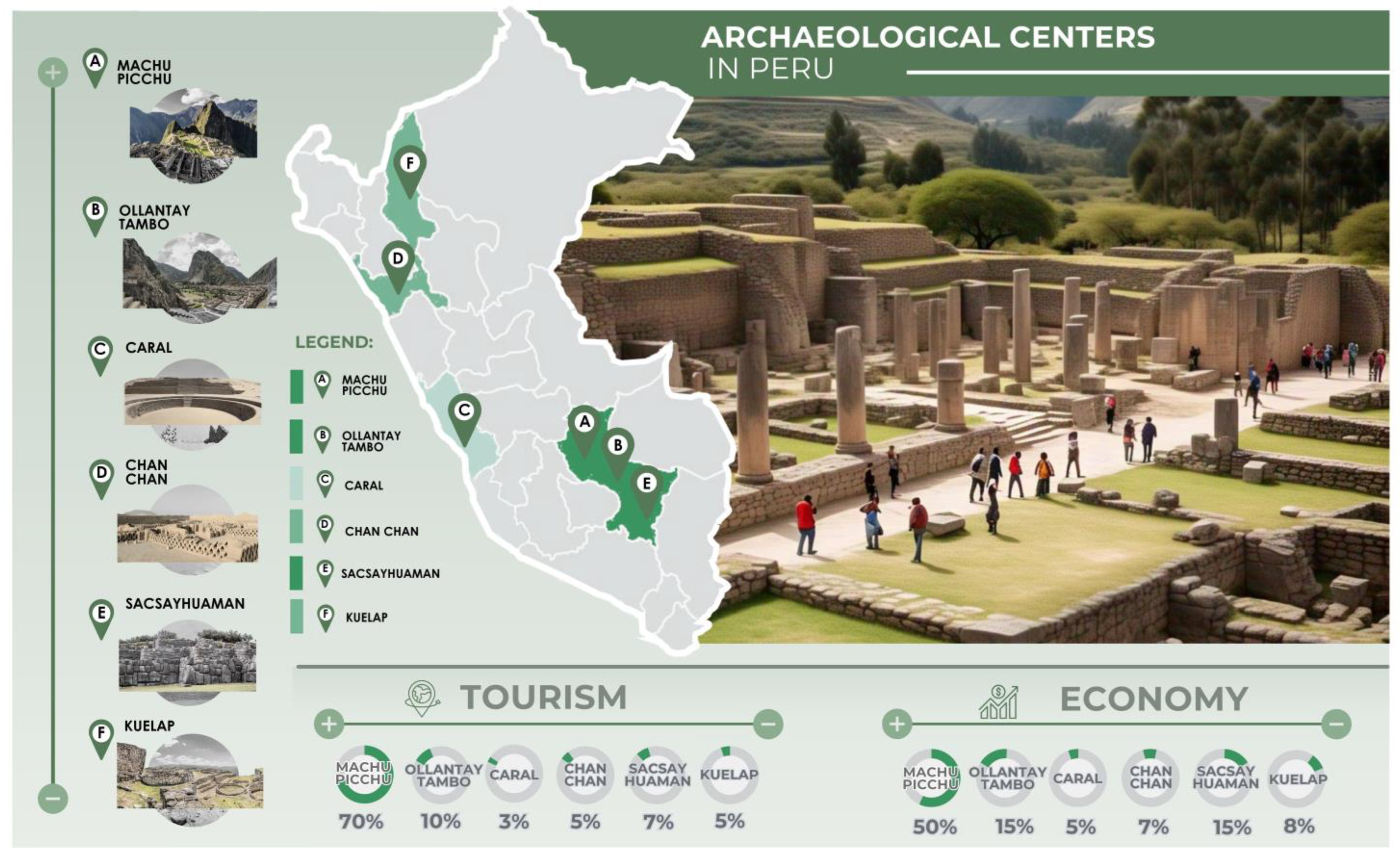
The most prominent archeological sites in Peru and their impact on tourism and the economy are depicted in Figure 3. Machu Picchu, shown in Figure 3A, is the most visited tourist destination in the country, attracting approximately 70% of international tourists and generating nearly 50% of the tourism sector’s revenue. Ollantaytambo, illustrated in Figure 3B and located in the Sacred Valley, receives around 10% of visitors and contributes 15% of the revenue. Caral, shown in Figure 3C, attracts 3% of tourists and accounts for 5% of revenue. Chan Chan, represented in Figure 3D, draws 5% of visitors and contributes 7% of revenue. Sacsayhuaman, indicated in Figure 3E, attracts 7% of tourism and generates 15% of the income. Kuelap, depicted in Figure 3F, also receives 5% of international tourists and has increased its economic impact to 8% due to investments in infrastructure [17].
The conservation of archeological sites is essential not only for understanding our history but also for strengthening cultural identity and encouraging responsible tourism that generates sustainable benefits for local communities. Beyond being tangible testimonies of the past, these sites represent a bridge toward sustainable tourism development [18].
Figure 3. Most representative archeological centers in Peru. (A) Machu Picchu, adapted with permission from Ref. [19]. 2021, UNESCO; (B) Ollantaytambo, adapted with permission from Ref. [20]. 2023, John, P.; (C) Caral, adapted with permission from Ref. [21]. 2021, Mayans, C.; (D) Chan, adapted with permission from Ref. [22]. 2024, Lr, E.; (E) Sacsayhuaman, adapted with permission from Ref. [23]. 2021, Sequeiros, J.; and (F) Kuelap adapted with permission from Ref. [24]. 2020, Plataforma del Estado Peruano. Figure created by the authors using Adobe Photoshop 2024.
Urbansci 09 00317 g003
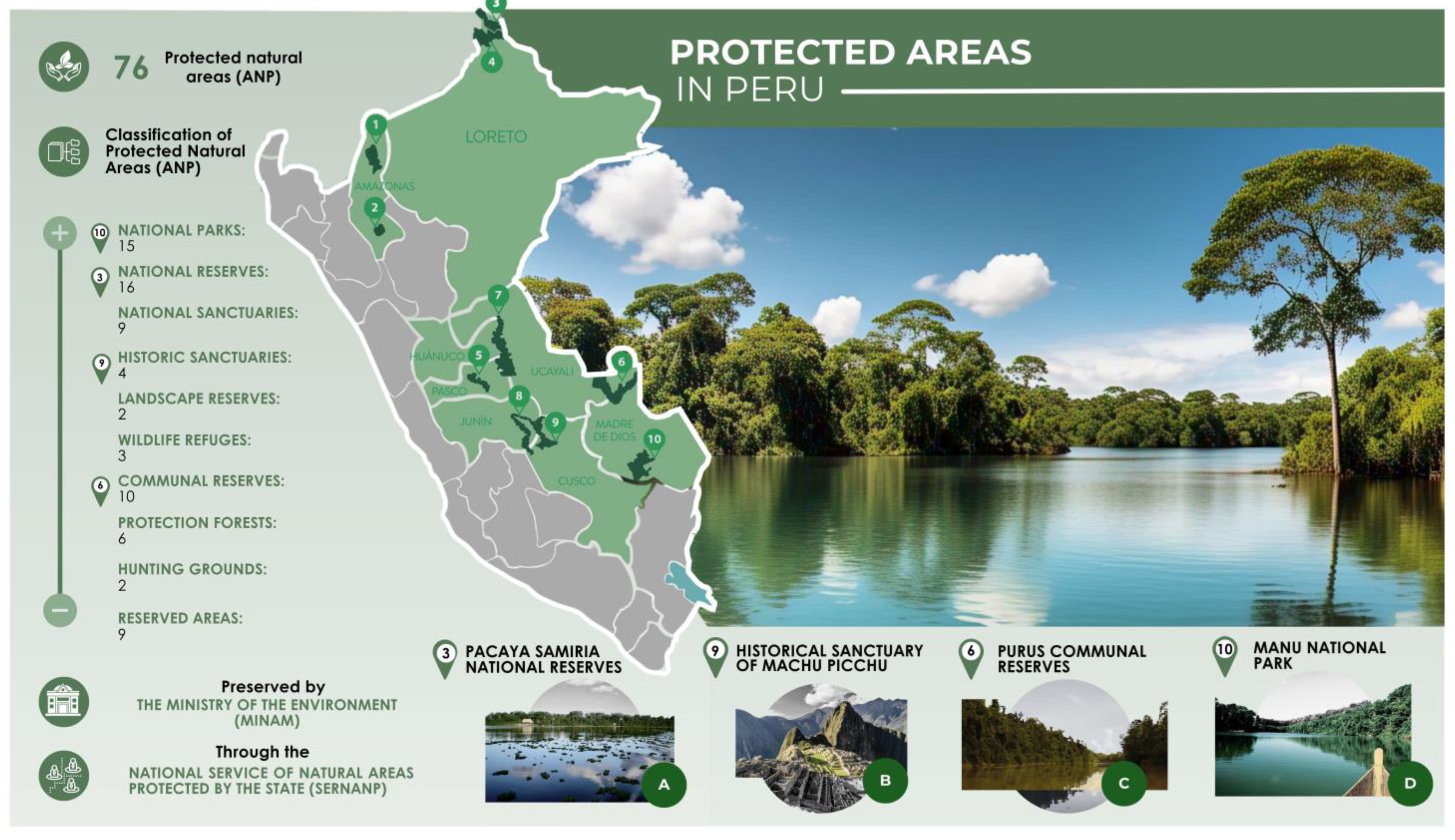
Likewise, in Peruvian territory, there are 76 Protected Natural Areas (PNAs), both in terrestrial and marine ecosystems, which are preserved by the Ministry of the Environment (MINAM) through the National Service of Natural Protected Areas by the State (SERNANP). These PNAs play an essential role in social cohesion, health, inclusion, and the well-being of the population, as they are a key strategy for preserving biodiversity and ensuring the provision of vital ecosystem services for future generations. Similarly, they play a crucial role in the conservation of biodiversity, ecosystems, and cultural, scenic, and scientific values [25].
The classification of Protected Natural Areas (PNAs) into ten categories is illustrated in Figure 4. The Pacaya Samiria National Reserve, shown in Figure 4A, focuses on biodiversity conservation and promotes the sustainable use of resources. The Historic Sanctuary of Machu Picchu, depicted in Figure 4B, stands out for its natural and cultural value, encouraging both research and tourism. The Purus Communal Reserve, shown in Figure 4C, supports rural communities through the responsible management of natural resources. Lastly, Manu National Park, represented in Figure 4D, exemplifies a National Park dedicated to conservation, research, and tourism. National Sanctuaries, Landscape Reserves, Wildlife Refuges, Protection Forests, Game Preserves, and Reserved Zones are categories of protected areas aimed at conserving biodiversity, enabling the sustainable use of natural environments, and regulating activities such as research, tourism, and hunting [26].
In addition to their ecological benefits, green infrastructure promotes social interaction, environmental awareness, and heritage conservation, creating resilient spaces that connect people with their history and ecosystem.
This raises the following question: To what extent can the architectural design of green infrastructure contribute to an increase in ecotourism at the Ollantaytambo archeological site, Urubamba Province, Peru, in 2024?
Throughout history, architecture has been closely connected to the natural environment, achieving a harmonious integration between constructions and the landscape. Ancient civilizations skillfully adapted their buildings to geographical and climatic conditions, applying advanced techniques that endure to this day.
The archeological site of Ollantaytambo, located in the district of Ollantaytambo, province of Urubamba, department of Cusco, at an altitude of approximately 2851 m above sea level, is an exceptional testament to Inca urban and military planning [30]. The name “Ollantaytambo” comes from Quechua: Ollanta, a character from Inca oral tradition, and tampu, meaning “resting place” or “inn,” reflecting its importance as a strategic point within the road network of the Tahuantinsuyo [31].
Ollantaytambo is distinguished by its monumental architecture and advanced urban planning, reflecting the Inca mastery of stonework and territorial management. Its pink granite walls, hydraulic system, and agricultural terraces with defensive functions highlight its significance as an administrative and military center [32]. A remarkable example of Inca craftsmanship is the Temple of the Sun, where the precise assembly of megalithic blocks demonstrates a profound understanding of engineering and astronomy [33].
Beyond its administrative and military functions, Ollantaytambo held great spiritual significance. Its design incorporates elements of the Andean worldview, in which the connection between humans, the natural environment, and deities was essential. Furthermore, it is believed that the site played a key role in ceremonies and rituals dedicated to the worship of water and the sun—both fundamental deities in Inca tradition [31].
The historical, architectural, and cultural richness of Ollantaytambo makes it one of the most outstanding treasures of the Sacred Valley of the Incas. Known as the “Living Inca City,” it is the only Inca settlement that is still inhabited, preserving its original layout and keeping its ancestral traditions alive [31], as shown in Figure 5.
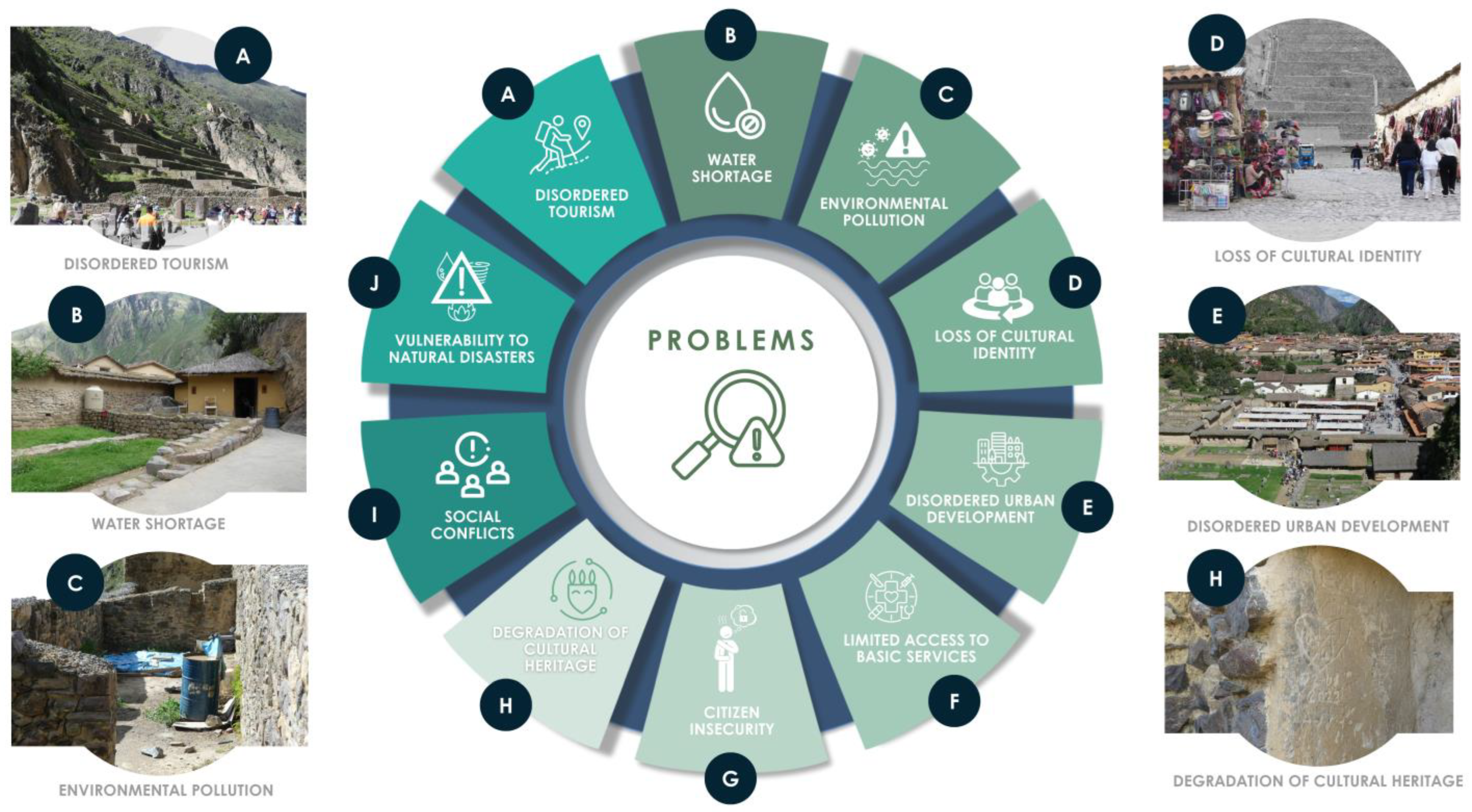
Despite its historical and architectural richness, Ollantaytambo faces multiple challenges that threaten its conservation and sustainability, as shown in Figure 6. One of the main issues is unregulated tourism, which has had a negative impact on the area by causing pollution, noise, and deterioration of cultural heritage. Figure 6A shows that 65% of the waste generated comes from tourist activities, while 50% of residents perceive a significant increase in noise levels in recent years [34].
Water scarcity, represented in Figure 6B, constitutes a significant issue affecting approximately 40% of the population, primarily due to the lack of adequate infrastructure. Likewise, environmental pollution, illustrated in Figure 6C, is exacerbated by the burning of waste, which accounts for 30% of air pollution. The absence of an efficient waste collection system has also led to a 25% increase in water pollution in the area [34].
Uncontrolled urban growth and the loss of cultural identity, as shown in Figure 6D,E, pose significant threats. Approximately 45% of local vendors have adapted their offerings to cater to tourism, abandoning traditional practices. The lack of urban planning has led to a 35% increase in traffic and a 20% reduction in public spaces. Furthermore, the insufficiency of basic services affects 30% of the population, negatively impacting their quality of life. Citizen insecurity, represented in Figure 6F, has increased by 25% due to limited police presence and inadequate street lighting. The degradation of cultural heritage, illustrated in Figure 6G, places 40% of archeological structures at risk due to insufficient maintenance and conservation efforts [34].
Social conflicts, represented in Figure 6H, have been triggered by the lack of citizen participation and transparency in resource management, generating discontent among at least 50% of the population. Finally, vulnerability to natural disasters remains a constant risk, as seen in Figure 6I, since Ollantaytambo’s geographical location exposes it to earthquakes, floods, and landslides, with 60% of the territory considered high-risk [34].
Accordingly, the present research aims to propose an architectural design for green infrastructure intended to enhance ecotourism at the Ollantaytambo archeological site, located in the Urubamba province, Peru, in 2024.

1.1. State of the Art

1.1.1. Theoretical Basis

Cultural Identity
Cultural identity is a social and symbolic process that enables individuals and groups to recognize and distinguish themselves, serving as a fundamental element for social cohesion, historical continuity, and the construction of meaning within human communities [35].
Cultural identity encompasses all cultural traits that lead individuals belonging to a particular human group and cultural level to perceive themselves as culturally alike [36].
Cultural Heritage
Cultural heritage encompasses the set of tangible and intangible assets inherited from past generations, which hold historical, artistic, scientific, or social value and are preserved for the benefit of present and future societies [37].
Cultural heritage includes monuments, sites, traditions, oral expressions, knowledge, and techniques that form part of a community’s identity and collective memory. Its preservation is essential for sustainable development and social cohesion [38].
Heritage Conservation
The conservation of cultural heritage refers to the set of actions aimed at protecting, maintaining, and safeguarding cultural assets, ensuring their transmission to future generations while respecting their historical, artistic, and social value [39].
Heritage conservation involves the application of interdisciplinary techniques and strategies to prevent deterioration, restore, and extend the lifespan of cultural assets, allowing for their appreciation and study by both present and future societies [40].
Green Infrastructure
Green infrastructure refers to an interconnected system of natural areas and other open spaces that preserve the functions and values of ecosystems while providing benefits to society, such as water management, enhanced biodiversity, and human well-being [41].
Urban green infrastructure integrates natural elements within cities, such as parks, green roofs, ecological corridors, and sustainable drainage systems, with the aim of creating more resilient, healthy, and resource-efficient environments [42].

2. Materials and Methods

2.1. Methodological Outline

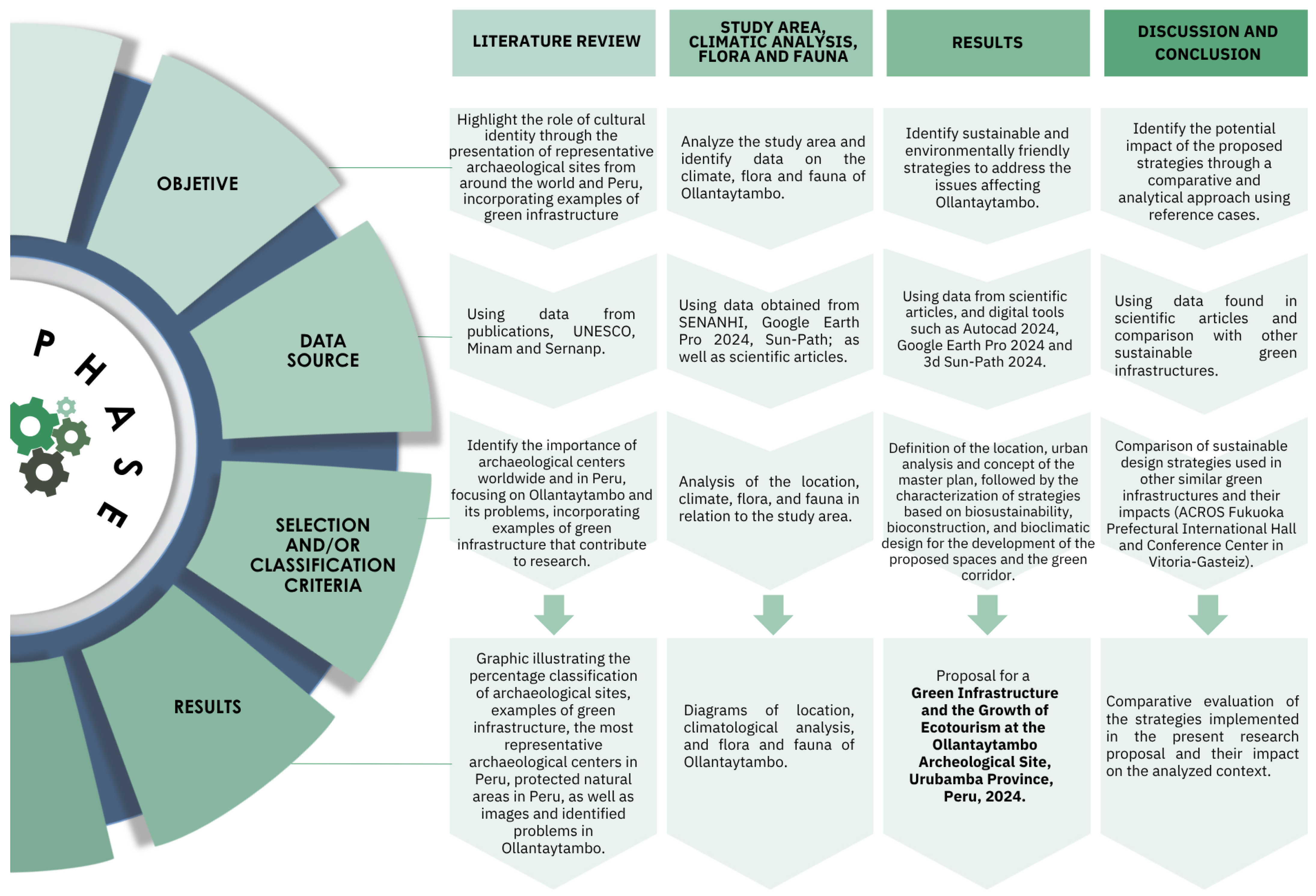
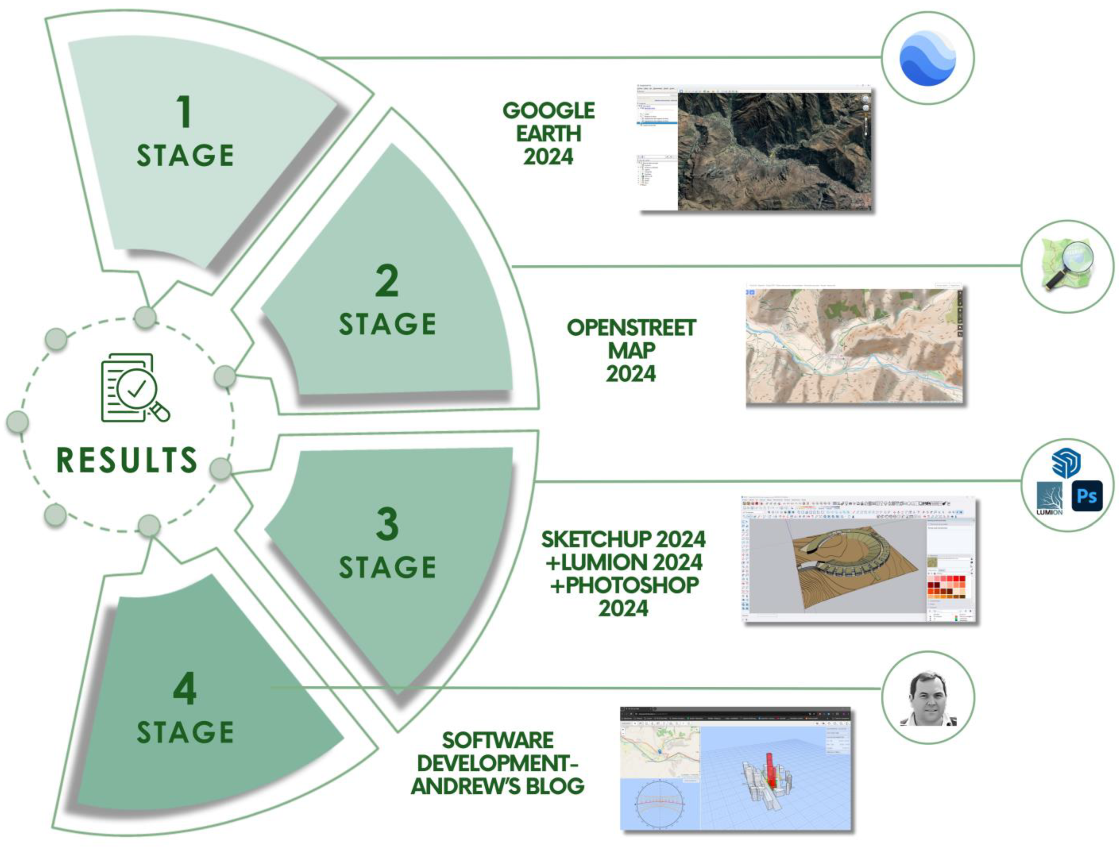
The design of green infrastructure to promote ecotourism at the Ollantaytambo archeological site was developed through an approach that integrates environmental, urban, and landscape aspects. This process was carried out in several phases and addressed by multidisciplinary technical teams, as illustrated in Figure 7.
This methodological structure is based on the authors’ previous research in Lima [43], where a similar framework was applied. In this case, it has been adapted to the mountainous region of Urubamba, which presents distinct topographic, climatic, and cultural conditions. The approach includes specific modifications in the site analysis and design criteria to address the needs of the Ollantaytambo archeological context.

2.2. Methodological Process

2.2.1. Literature Review

During the first phase of the study, a detailed bibliographic analysis was conducted to gather relevant information on cultural heritage, considering that archeological sites are fundamental within heritage contexts. This process established a solid theoretical foundation for the proposed architectural design at the Ollantaytambo archeological site. Academic research on environmental sustainability, scientific publications from organizations such as UNESCO, and successful cases of green infrastructure with cultural identity in various regions of the world were reviewed. The literature review enabled the identification of sustainable design principles applicable to heritage contexts, defining parameters regarding the use of green walls, efficient irrigation systems, and the integration of native flora. Additionally, it contributed to understanding the challenges of heritage protection in both urban and rural areas, as well as the opportunities to promote economic and social development through sustainable ecotourism.

2.2.2. Site Analysis

During the second phase of the study, a detailed analysis of the intervention site in the district of Ollantaytambo, located in the Urubamba province, Peru, was carried out. This process included the precise location of the area using tools such as Google Earth Pro 2024, which allowed for terrain exploration, measurement of specific areas, and determination of exact coordinates to gain a better understanding of the environment [43].
Climate analysis was a crucial part of the process [44]. For this purpose, maximum and minimum temperatures, wind speed, relative humidity, and precipitation were evaluated. The process is detailed as follows:
  • Collection of hydrometeorological data from SENAMHI’s Urubamba meteorological station, covering a five-year period (2019–2024). The data included maximum and minimum temperatures (°C), relative humidity (%), and precipitation (mm).
  • Collection of meteorological data from MeteoBlue EPW for the year 2024, including wind speed (km/h).
  • Estimation of solar radiation based on EPW data from MeteoBlue (2024), considering an average global horizontal irradiation (GHI) of 6.0 kWh/m2/day, supported by previous studies in high Andean regions of Peru (MDPI, 2024).
  • Detailed evaluation of the collected data through statistical analysis.
  • Development of graphs representing the parameters mentioned in points 1 and 2.
Finally, local ecosystems were assessed, with special attention given to native flora and fauna, such as ichu grass, queñuales (Polylepis trees), condors, and vizcachas. This analysis ensured that the green infrastructure strategies would respect and harmoniously integrate with the natural environment of the Sacred Valley, reinforcing its sustainability.

2.2.3. Results

Site Analysis: This stage analyzes the relationship between heritage and the surrounding environment, taking into account history, materiality, and landscape integration. Using Google Earth Pro 2024 to delimit the Ollantaytambo area, the intervention site was identified, including its archeological center and the Urubamba River as a key water resource. This study is essential for both conservation and sustainable design.
Master Plan Analysis: This stage involves collecting environmental information through OpenStreetMap, identifying water bodies, green areas, roads, and buildings. Based on this analysis, the master plan defines four key components: the Cultural Outreach Center, camping areas, scenic viewpoints, and an ecological corridor, integrating heritage conservation with sustainable development.
Analysis of Proposed Spaces: In this stage, proposed spaces were defined by considering the integration of cultural heritage with the natural environment. A three-dimensional terrain and topographic model were developed using SketchUp 2024, which facilitated a spatial understanding of the intervention area. Based on this analysis, four main components were proposed: the Cultural Outreach Center, camping areas, viewpoints, and an ecological corridor, fostering sustainable planning in harmony with the landscape.
Analysis of Applied Strategies: This stage involved an analysis of strategies applied across three main axes: biosustainability, bioconstruction, and bioclimatic design. For this purpose, 3D Sun-Path 2024 was used to evaluate solar radiation on terraces, walls, and canals within the system, enabling design optimization in terms of thermal comfort, energy efficiency, and environmental integration. These strategies ensure a balance between heritage conservation and sustainability by promoting the use of local materials, traditional construction techniques, and the efficient use of natural resources.
During the third phase of the study, the key processes for analyzing and diagnosing the study area were defined using digital tools. In the first stage, the district boundaries of Ollantaytambo were established using Google Earth Pro 2024, allowing for the acquisition of precise coordinates and specific land measurements. In the second stage, elements of the immediate environment—such as water bodies, green areas, access roads, and buildings—were identified and mapped using OpenStreetMap 2024. In the third stage, a three-dimensional model of the terrain and its topography was developed using SketchUp 2024, which facilitated spatial understanding of the intervention area. Additionally, Lumion 2024 was used for realistic rendering and visualization of the environment, and Adobe Photoshop 2024 was employed for final touch-ups and graphic presentation of the project. Finally, in the fourth stage, a comprehensive analysis using 3D Sun-Path 2024 was conducted to examine how solar radiation affects terraces, walls, and canals within the system, as shown in Figure 8.

2.2.4. Discussion and Conclusions

Finally, in the fourth stage, a comparison will be made between the ACROS Fukuoka Prefectural International Hall and the Conference Center in Vitoria-Gasteiz.

2.3. Study Area

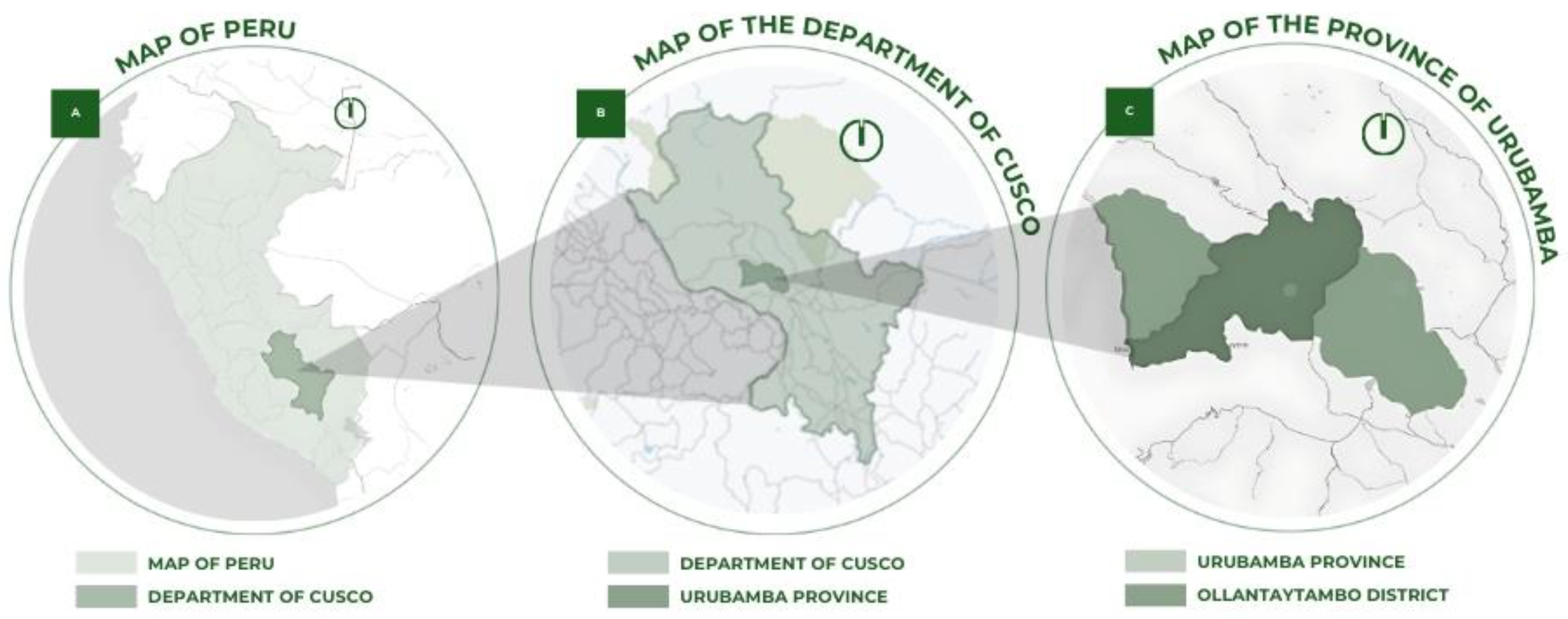
The location of the Ollantaytambo archeological site, situated in the District of Ollantaytambo, Province of Urubamba, Department of Cusco, Peru, is shown in Figure 9 [45]. It is located approximately 43 km from the city of Cusco, one of the country’s major urban centers and the former capital of the Inca Empire. This archeological complex is part of the Sacred Valley of the Incas, a region rich in history and cultural heritage [45,46].

2.4. Climate Analysis

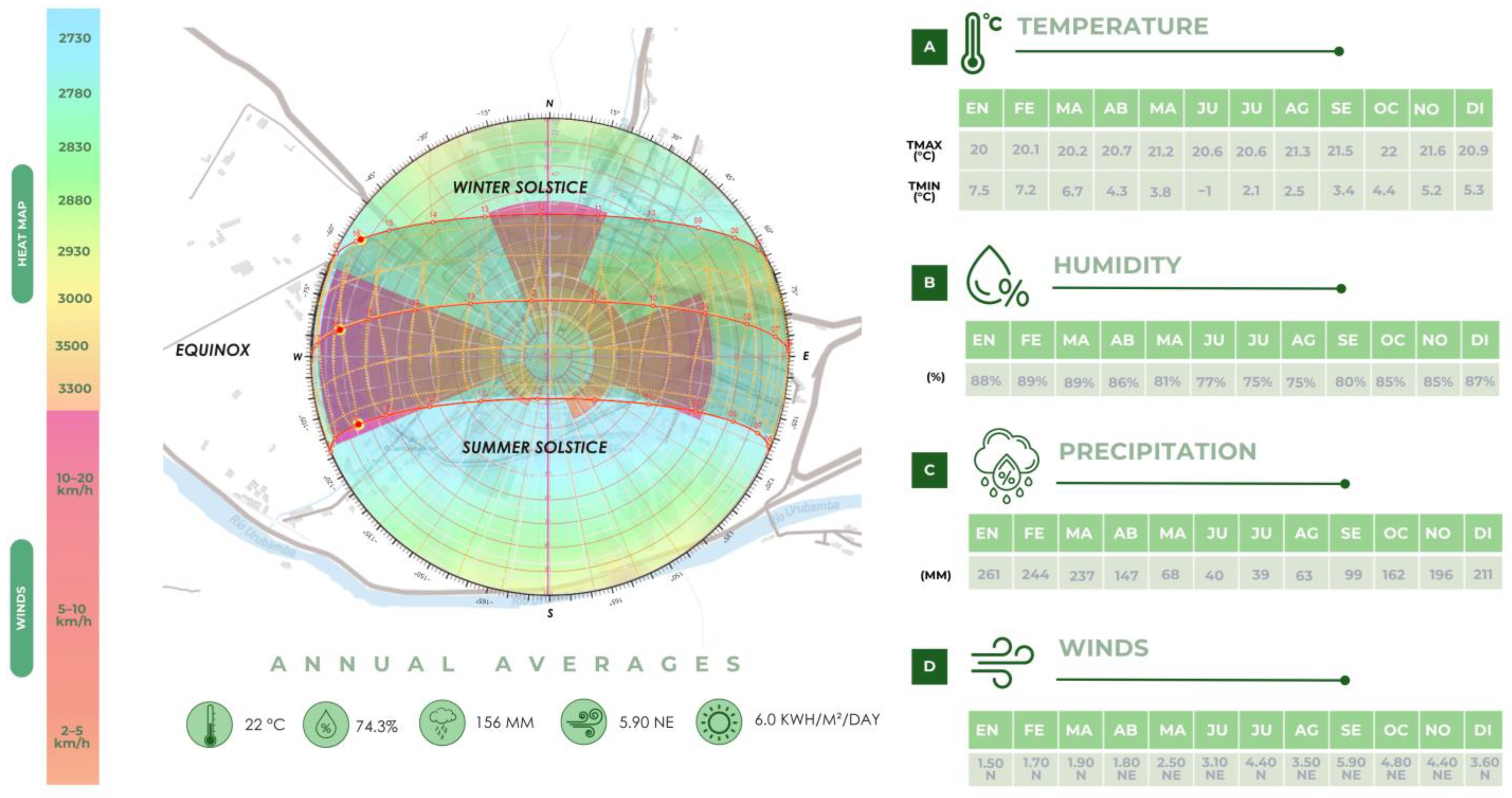
The climatological analysis of Ollantaytambo, presented in Figure 10, shows that this town in the Sacred Valley of the Incas features a temperate Andean climate characterized by dry winters and mild summers. According to the SENAMHI climate classification shown in Figure 10A, its climate is defined as semi-dry and temperate, C(o, i) B’, with dry autumn and winter seasons [47]. The average annual maximum temperature reaches approximately 22 °C, while during the coldest months—June through August—temperatures can drop as low as 0 °C. In October 2023, the highest maximum temperature in the past five years was recorded at 25.3 °C, whereas the lowest minimum temperature was reported in June 2022 at −2 °C [48].
These climatic conditions favor the growth of native flora—species that play an essential role in conserving the local ecosystem. The region’s climate and geographic configuration not only support biodiversity but also influence the planning of sustainable strategies aimed at preserving both the natural and cultural environment.
The average annual relative humidity is 67%, with a notable increase during February and March, when it reaches an average of 89%. Between June and August, humidity levels drop to around 75%, as illustrated in Figure 10B. The lowest relative humidity was recorded in July 2020, while the highest was observed in February 2023 [48].
The precipitation regime follows a seasonal pattern. From December to March, rainfall increases significantly, with February being the wettest month—reaching up to 261 mm. In contrast, from June to August, precipitation levels drop drastically, averaging just 40 mm. This phenomenon, shown in Figure 10C, has been exacerbated by the impacts of climate change, affecting the water balance of the local ecosystem [48].
The prevailing wind in Ollantaytambo comes from the northeast, with an average speed ranging between 1.5 and 5.90 m per second, as shown in Figure 10D [49].
Additionally, the average daily solar radiation in Ollantaytambo is 6.0 kWh/m2/day, a favorable condition for the implementation of photovoltaic systems in sustainable architectural and energy planning [49,50].

2.5. Flora and Fauna

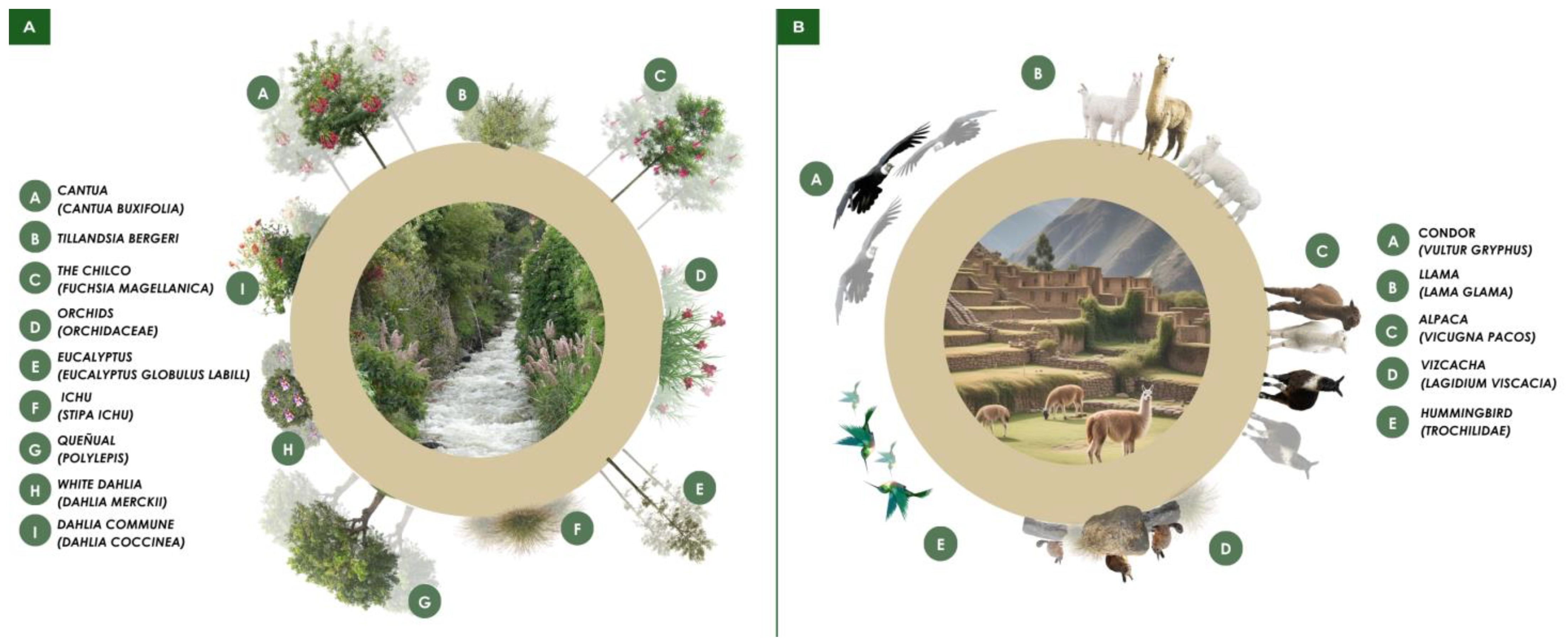
The flora and fauna of Ollantaytambo exhibit a wide diversity of species that enrich its ecosystem. Among the predominant vegetation are ichu grass, queñual trees (Polylepis), eucalyptus, and a wide variety of orchids, as shown in Figure 11A. Regarding fauna, birds dominate the skies—most notably condors and hummingbirds—while on land, llamas and alpacas are commonly seen. In addition, rodents such as the vizcacha can also be found [51], as represented in Figure 11B. This diversity of species contributes to the natural richness of this ancient village in the Sacred Valley of the Incas.
The flora of Ollantaytambo, an ancient Inca settlement located in Peru’s Sacred Valley, is illustrated in Figure 11A. This flora is both diverse and unique, having adapted to the region’s specific climatic and geographic conditions. Ichu grows at elevations between 3700 and 4800 m above sea level, queñual trees can be found between 3600 and 4500 m, orchids thrive at approximately 4500 m, and eucalyptus trees grow at around 3400 m [51].
The diverse fauna, adapted to the conditions of the Andes and the Sacred Valley, contributes significantly to the region’s identity and is depicted in Figure 11B. Birds dominate the skies, from majestic condors to vibrant hummingbirds. On the ground, llamas and alpacas graze peacefully, while vizcachas emerge from between the rocks. Hummingbirds and colorful butterflies dance among the vegetation, while amphibians and reptiles find refuge in the quieter corners of the landscape.
This combination of flora and fauna creates a rich and unique ecosystem, adding a special charm to the historical and natural beauty of Ollantaytambo.

3. Results

3.1. Place of Study

The proposal is located in the urban area of the Ollantaytambo district, which includes the Ollantaytambo Archeological Center with a surface area of 9600 m2 and a perimeter of 410 linear meters. This district is situated 71.8 km from the city of Cusco, at an altitude of 2792 m above sea level, with coordinates 13°15′29″ S latitude and 72°15′48″ W longitude, as shown in Figure 12. An important water resource in the study area is the Urubamba River, which is a main tributary of the Ucayali River, and in turn, part of the Amazon River basin [52].

3.2. Diagnosis of the Study Area

Urban Analysis

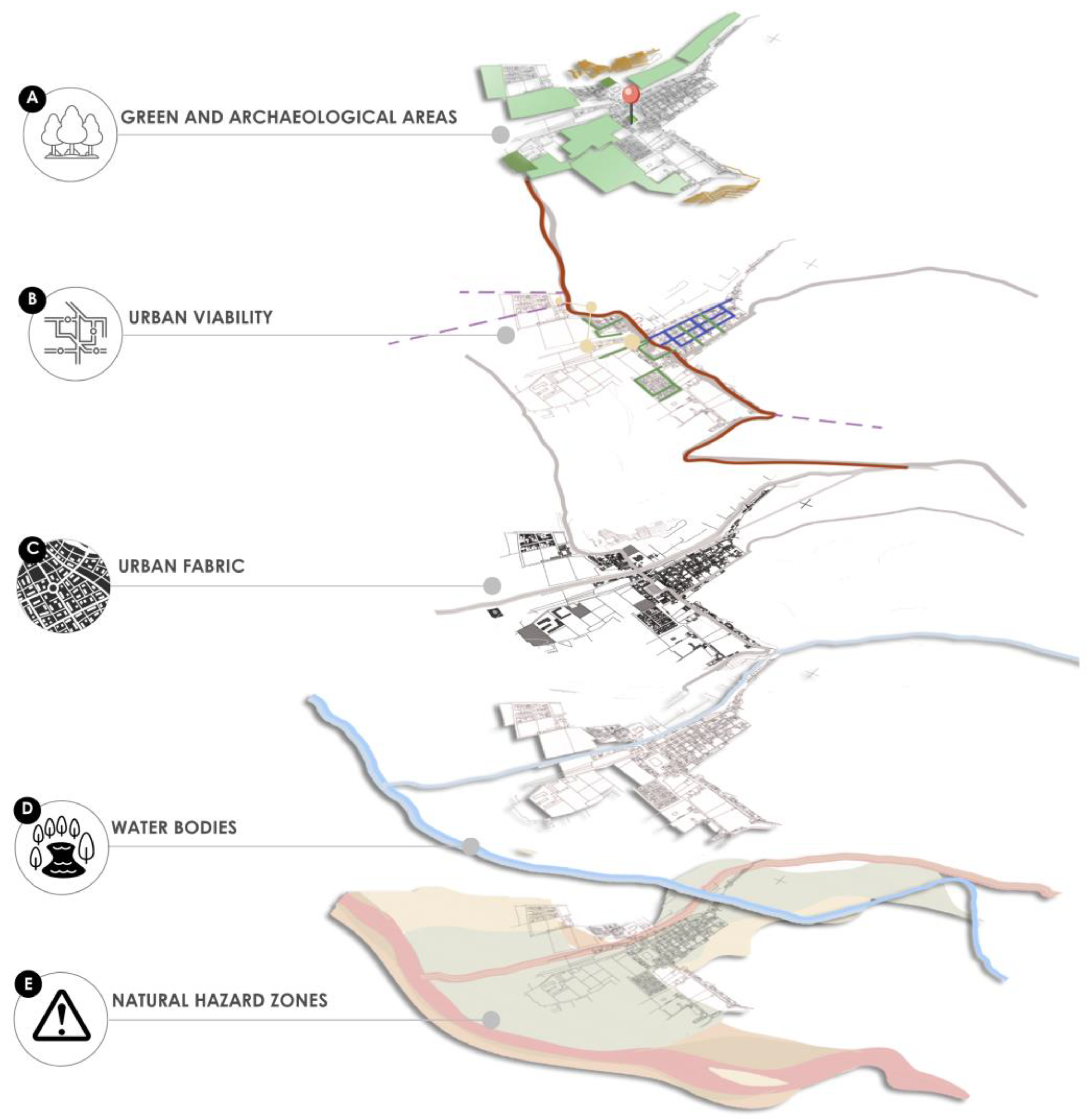
In Figure 13, a comprehensive spatial analysis of the district of Ollantaytambo is presented through the superimposition of various thematic layers, which allow for an understanding of the interaction between the natural, cultural, and urban elements of the territory. The green and archeological areas, represented in Figure 13A, correspond to zones of high landscape, environmental, and heritage value within the district. This layer identifies spaces dedicated to traditional agriculture, terracing systems, riparian forests, and archeological sites of significant historical relevance. These elements not only shape the territorial identity of the area but also constitute strategic zones for conservation and the regulation of urban growth.
The urban road network, illustrated in Figure 13B, highlights the infrastructure that articulates the urban area of Ollantaytambo with its surrounding environment. The main axes that structure local and regional mobility are emphasized, including access routes to the historic center, connections to Machu Picchu, and links with the Cusco–Quillabamba highway. This infrastructure, in addition to facilitating the transport of residents and tourists, also influences urban expansion and delineates the district’s operational boundaries [53].
The urban fabric, represented in Figure 13C, reveals the configuration and morphology of the built environment. Areas with an orthogonal layout—typical of colonial planning—are identified, contrasted with zones of recent growth that display an irregular and dispersed structure. This analysis evidences the coexistence of a consolidated historic core with expanding urban areas that require planning interventions to ensure orderly territorial occupation [53].
The water bodies, shown in Figure 13D, primarily include the Patakancha and Vilcanota rivers, which traverse the district and are fundamental natural elements for the ecological and urban dynamics of the area. This layer enables the identification of zones with direct hydrological influence, relevant for productive, supply, and recreational purposes, while also highlighting areas potentially at risk due to extreme weather events [53].
Finally, the natural hazard zones, represented in Figure 13E, encompass areas susceptible to landslides and flooding, particularly along riverbanks and in steep-sloped regions. This information is essential for assessing territorial vulnerability, as it allows for the delimitation of areas unsuitable for urban development and guides the formulation of mitigation strategies in the face of natural threats [54].

3.3. Concept

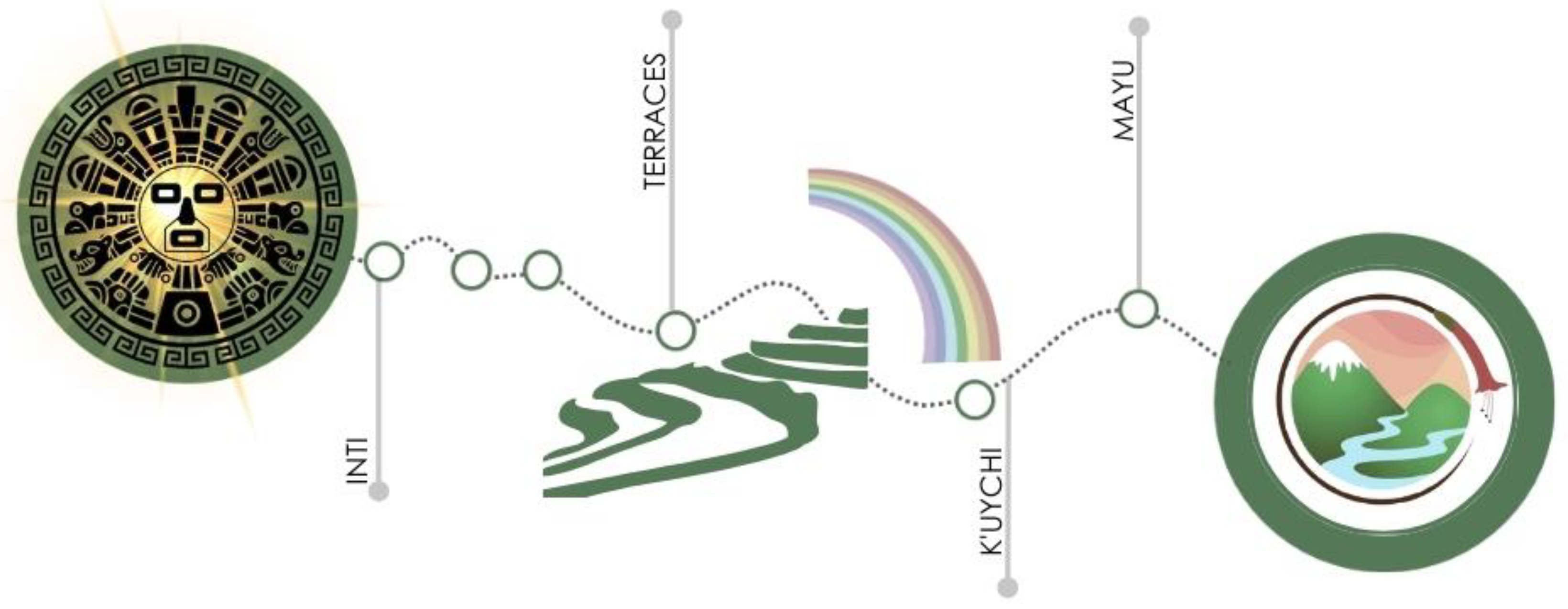
The essence of the project reflects a focus on sustainability and the conservation of nature with ecological practices. The image symbolizes a journey that begins with Inti, representing solar energy and the Andean worldview, followed by terraces that allude to sustainable agricultural techniques. The Kuychi (rainbow) symbolizes harmony with nature, while Mayu (river) emphasizes the value of water as an essential element for life. Together, these elements reinforce the connection between culture, landscape, and sustainability, promoting a tourism experience in balance with the environment, as illustrated in Figure 14.
The key components of the concept include landscape integration, with a design inspired by the natural curves of the terrain and the use of local vegetation to minimize visual impact; environmental sustainability, through renewable energy, water management, and the use of local materials; the promotion of educational ecotourism, with interpretive trails, viewpoints, and cultural spaces; and heritage conservation, protecting the archeological site and revitalizing local traditions, all in harmony with the natural and cultural environment.

3.4. Master Plan and Zoning

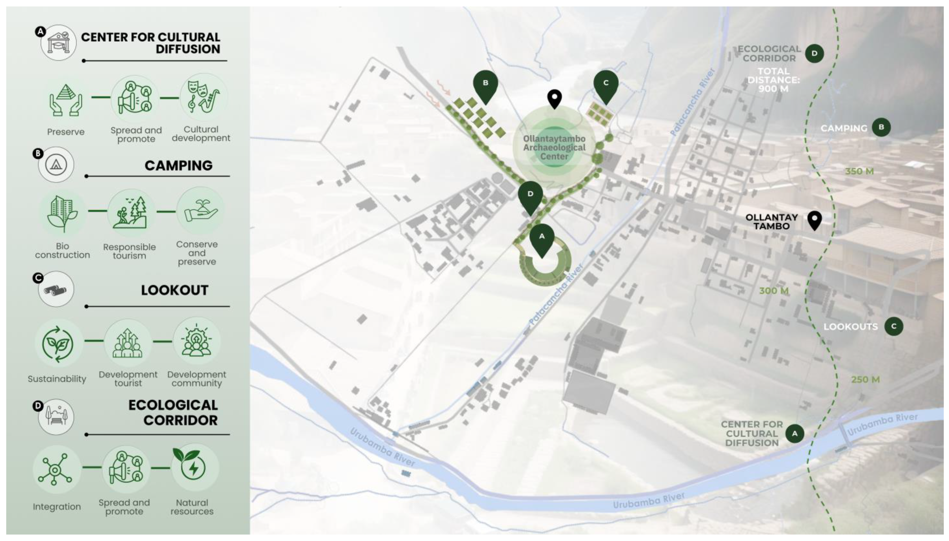
In this context, Figure 15 presents an integrated intervention proposal for the district of Ollantaytambo, grounded in the previously developed territorial diagnosis, which revealed a high concentration of patrimonial, environmental, and cultural values, as well as pressures resulting from unregulated urban growth and mass tourism. The proposal aims to articulate the existing elements of the territory through functional, sustainable, and culturally inclusive spaces.
The Cultural Diffusion Center, represented in Figure 15A, is proposed as a space dedicated to the preservation, promotion, and activation of tangible and intangible cultural heritage. Its strategic location near the archeological complex allows for direct interaction with tourist flows without compromising the integrity of the site. This facility will support educational, artistic, and community-based activities, reinforcing local identity and promoting sustainable cultural development.
The camping area, illustrated in Figure 15B, is located 350 m from the archeological core. This area is designed under principles of bioconstruction and responsible tourism, offering experiences of direct contact with the natural environment. Furthermore, its placement helps to relieve pressure on the central urban lodging infrastructure, providing a sustainable alternative that respects the territory’s morphology and contributes to the conservation of sensitive natural areas.
The lookout points, represented in Figure 15C, are situated 250 m from the archeological site and enable the appreciation of Ollantaytambo’s cultural landscape. These observation points are intended to integrate the tourist experience with the enhancement of the natural and built environment, without causing negative visual or physical impacts. They also serve as nodes for environmental and heritage interpretation, fostering visitor awareness and education about the territory’s value.
Finally, the ecological corridor, shown in Figure 15D, proposes a 900 m route that connects the various interventions, creating a green network that integrates natural, patrimonial, and cultural areas. This green infrastructure not only promotes environmental connectivity but also functions as public space for recreation and education, improving residents’ quality of life and enhancing the tourist experience in a sustainable manner.
Overall, the proposal promotes a vision of balanced territorial development, in which heritage conservation, environmental sustainability, and the strengthening of local sociocultural structures are harmoniously integrated. This intervention responds to the identified challenges and offers a viable alternative for the orderly management of a highly sensitive patrimonial and ecological setting.
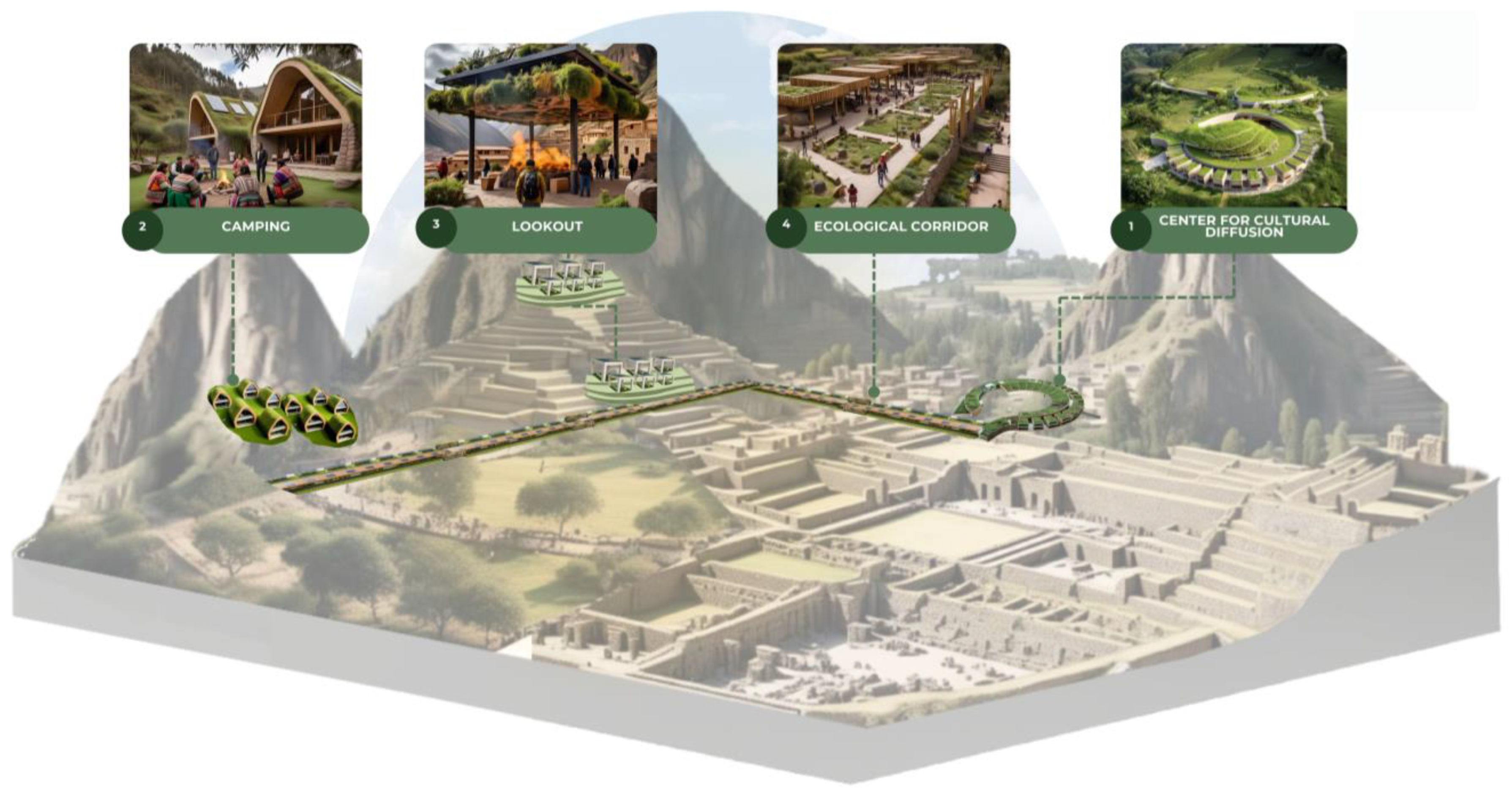
The proposal incorporates elements of sustainable infrastructure and tourist spaces that are harmoniously integrated with the natural environment and cultural heritage. The cultural information center aims to revalue local history and traditions, while the camping area offers an immersive experience in nature. The viewpoint allows visitors to appreciate the landscape without affecting the heritage site, and the ecological corridor connects the spaces while promoting biodiversity. Together, the project promotes a model of sustainable ecotourism that respects the cultural identity and environmental balance of Ollantaytambo, as shown in Figure 16.
The design of green infrastructure to promote ecotourism in Ollantaytambo focuses on three key objectives, all linked to local resources. This initiative aligns with the Sustainable Development Goals (SDGs), specifically goals 3, 7, 9, 11, and 13, which promote well-being, sustainable energy, innovation, resilient cities, climate action, and ecosystem conservation.
Likewise, the master plan incorporates universal accessibility principles to ensure the inclusion of all individuals, regardless of their physical, sensory, or cognitive abilities. The proposal includes accessible pathways with gentle slopes, appropriate paving, intermediate rest areas, and signage adapted in multiple formats (visual, tactile, and auditory). Additionally, the integration of digital technologies is considered for online information access, including audio guides, easy-to-read content, and sign language translation. These strategies strengthen the project’s educational and participatory character, ensuring an equitable, comprehensible, and autonomous tourism experience for all visitors.

3.5. Proposed Spaces and Applied Strategies

3.5.1. Camping Areas

Biosustainability
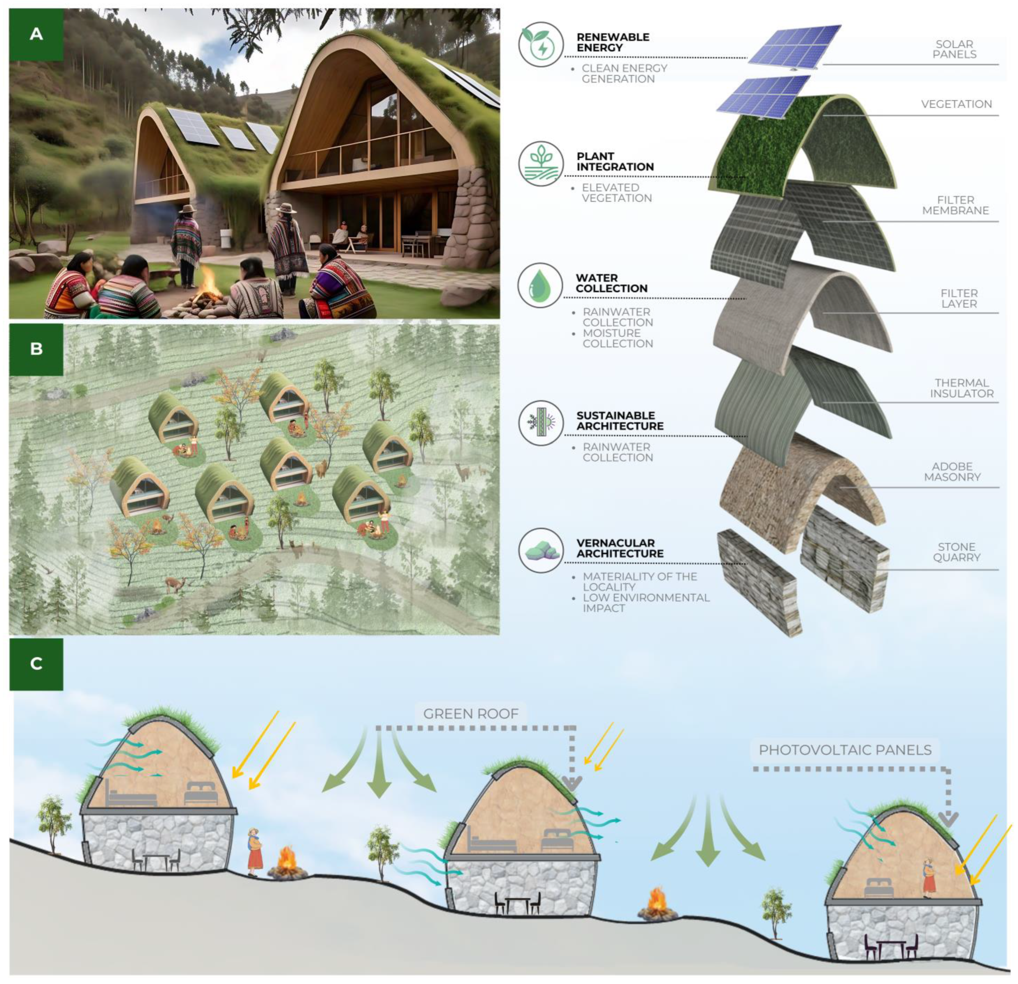
The implementation of passive strategies and the use of natural materials are key to ensuring thermal comfort and energy efficiency in the dwellings, as shown in Figure 17. The combination of green roofs and solar panels, represented in Figure 17A, not only reduces the carbon footprint but also improves thermal regulation, ensuring a comfortable environment throughout the year. The buildings stand out for their curved green roofs, which, in addition to blending with the landscape, function as natural insulators by retaining moisture and minimizing thermal transfer. This is complemented by the installation of solar panels on the roofs, optimizing the capture of renewable energy and promoting energy self-sufficiency.
In this regard, 65 solar panels were installed on the roofs of the camping modules to ensure the site’s energy supply. Specifically, five modules are equipped with 9 panels each, and two modules with 10 panels each. These panels, mounted on the green roofs, are strategically arranged in rows to optimize sunlight capture during the day, maximize energy generation, and facilitate maintenance access.
The strategic arrangement of the complex in relation to the terrain’s topography allows for a harmonious adaptation to the environment and better use of natural resources, as illustrated in Figure 17B. The location of the dwellings encourages cross ventilation and natural lighting, reducing the need for artificial climate control systems and promoting a sustainable lifestyle.
Meanwhile, Figure 17C presents a detailed analysis of the construction systems used. The combination of quincha (a traditional construction method) and wood in the structure allows heat to dissipate through internal air chambers, functioning as a thermal barrier that minimizes heat transfer. This strategy is complemented by the green roof, which not only reduces heat accumulation on the rooftops but also regulates indoor temperature by absorbing solar radiation and enhancing rainwater collection.
Finally, natural ventilation is optimized through the entry of cool air currents via strategically located openings, while warm air is gradually released through the upper part of the structure. This passive ventilation system helps keep the interior cool during the day and retains warmth during cold nights. The diagram illustrates how these strategies ensure stable indoor temperatures, guaranteeing the well-being of the occupants and promoting a sustainable housing model in harmony with the environment.
In the camping areas, the implementation of photovoltaic panels is being carried out as a sustainable solution to meet the energy demand of the various functional zones. These panels are essential to ensure a clean and efficient power supply. Table 1 details the technical specifications of the selected panel: a 550 W monocrystalline solar panel by EcoGreen Energy, distributed by Panel Solar Perú, with an efficiency of 20.58%.
Furthermore, the maximum electrical demand has been calculated by considering various devices such as lighting fixtures, emergency lights, standard sockets, computer outlets, and Wi-Fi points, as shown in Table 2. This assessment includes the number of devices, their wattage, diversity factor, and maximum demand, resulting in a total of 3552.4 W (3.5524 kW).
Table 3 shows the total monthly energy required in the camping areas. A 15-day-per-month operation with 24 h daily usage has been considered, to ensure a continuous-use and clearance area. Under these conditions, the monthly energy demand amounts to 1278.864 kWh, and the annual demand reaches 15,346.368 kWh.
On the other hand, energy production through solar panels has been calculated based on a daily solar radiation of 6.0 kWh/m2/day and an efficiency of 20%. As indicated in Table 4, 65 panels are proposed to meet this demand: five camping modules will be equipped with 9 panels each, and two modules with 10 panels. This distribution even allows for a surplus of energy, which can be reused within the system, achieving a monthly production of 1287 kWh and an annual production of 15,444 kWh.
Finally, Table 5 presents a comparison between the energy demanded and the energy supplied. It shows that the solar panels fully meet both the monthly and annual energy needs of the camping areas, slightly exceeding the projected demand, which demonstrates the efficiency of the proposed system.

3.5.2. Lookouts and Ecological Corridor

Bioconstruction
The design of the lookout follows sustainability principles, employing natural and recycled materials and techniques to minimize environmental impact and integrate construction methods that optimize thermal efficiency and harmony with the landscape, as shown in Figure 18. The use of compacted earth, known as rammed earth, and adobe provides thermal mass, regulating indoor temperatures and offering a rustic finish that blends with the surroundings.
The green roof serves a dual purpose: it regulates temperature by reducing heat accumulation and retaining moisture, while also visually integrating with the natural environment, reinforcing the connection between architecture and landscape. Similarly, the quincha envelope—a technique based on woven cane and mud—allows for a lightweight and breathable structure that enhances thermal comfort.
The project’s sustainability is also reflected in the responsible selection of materials. The lookout’s furniture is made from reclaimed wood, avoiding unnecessary logging and promoting the use of local resources. Additionally, demolition materials, such as stones extracted from nearby excavations, have been reused, reducing waste and minimizing the carbon footprint [56].
The integration of these systems with traditional construction techniques, such as those used in the vernacular architecture of Cusco, strengthens the cultural identity of the project. This approach not only provides structural stability and climate adaptation but also allows the lookout and surrounding spaces to blend harmoniously into the landscape.
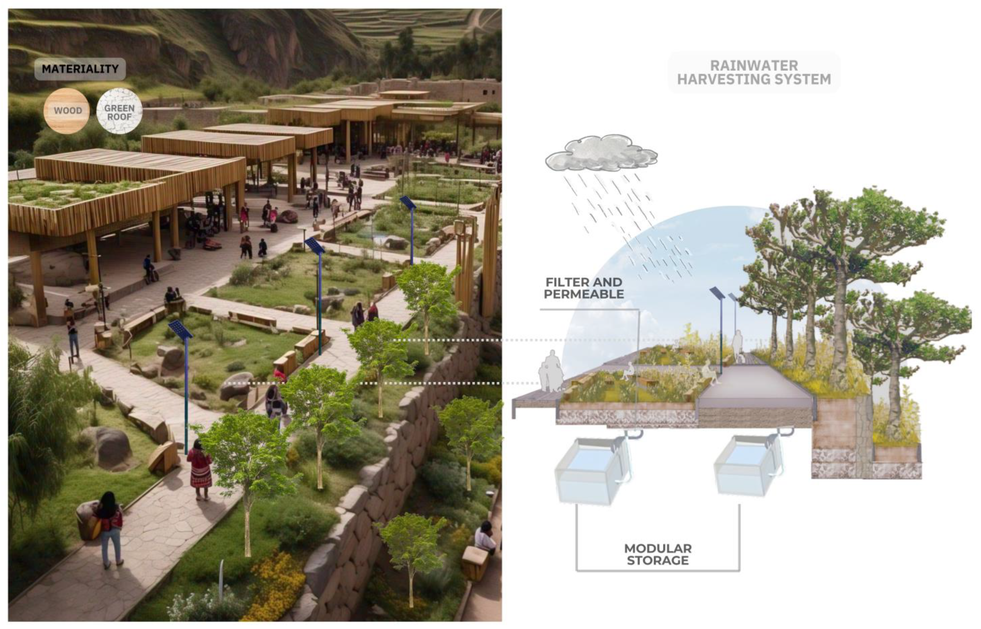
The proposal for the ecological corridor integrates sustainable strategies that promote environmental integration and the responsible use of resources. To achieve this, ecological materials such as wood and green roofs are used, improving thermal efficiency and reducing environmental impact.
A rainwater harvesting system is implemented, designed to collect, filter, and store rainwater, allowing its reuse for irrigation of vegetation and other activities within the corridor, as shown in Figure 19. The process begins with the collection of water through green roofs and permeable surfaces, which direct the flow into a natural filtration system composed of layers of gravel, sand, and vegetation. This filter helps retain sediments and impurities before the water reaches the underground storage modules.
The modular tanks ensure efficient water use by gradually distributing it according to the needs of the ecological corridor’s ecosystem. Additionally, the combination of drip irrigation and capillary systems optimizes plant hydration without generating waste, promoting the conservation of water resources.
The integration of these mechanisms with the infrastructure of the ecological corridor not only ensures the project’s water self-sufficiency but also aids in the regeneration of the natural landscape. The strategic arrangement of vegetation strengthens biodiversity, while the pathways and communal spaces have been designed to offer thermal comfort and encourage social interaction in a balanced environment with nature.
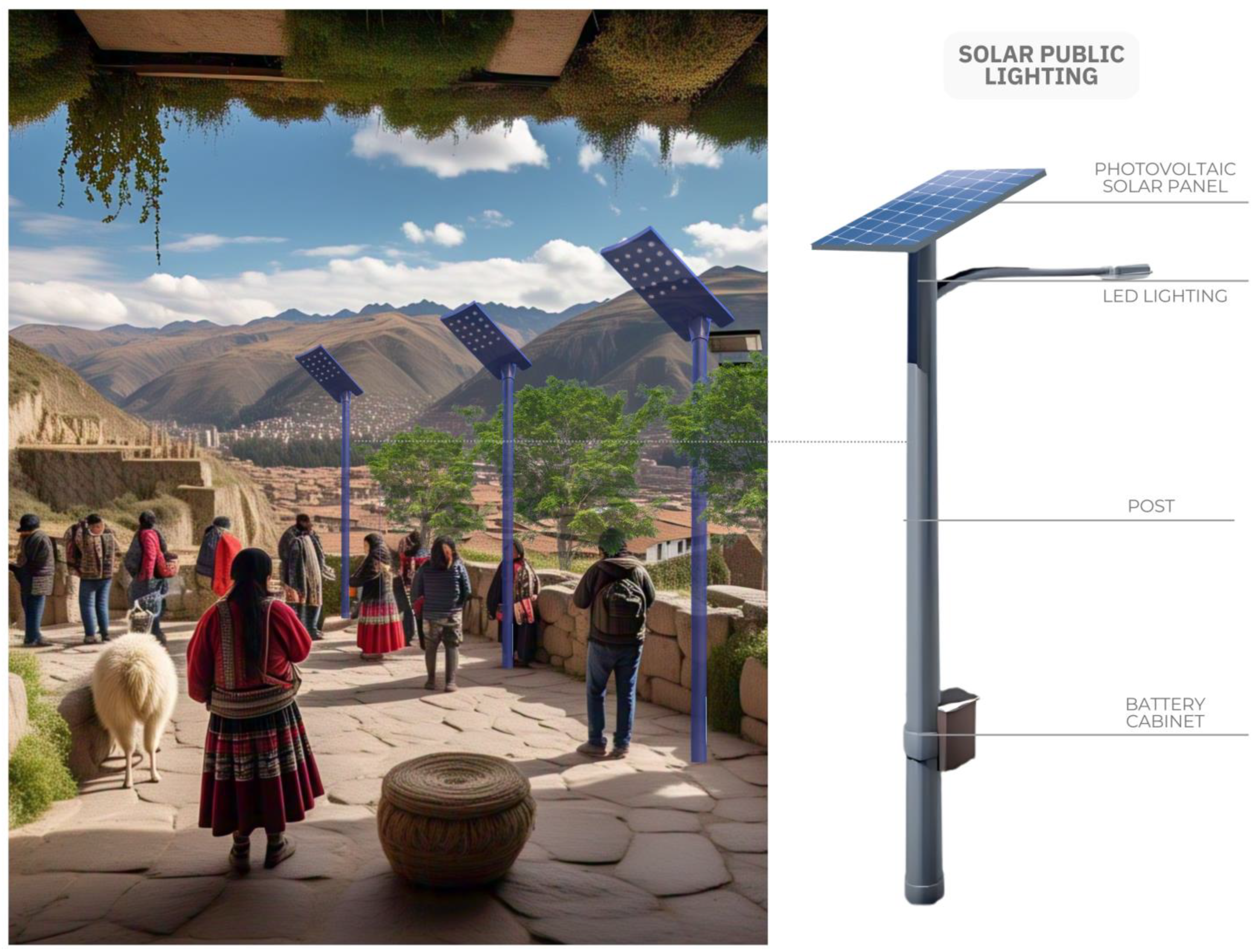
The solar public lighting system, shown in Figure 20, harnesses solar energy through photovoltaic panels that store electricity in batteries to power LED lights, thus optimizing energy consumption. This implementation aligns with the project’s principles of sustainability and energy efficiency, ensuring efficient and self-sufficient lighting during the night while reducing dependence on conventional energy sources.
The posts are equipped with photovoltaic solar panels that capture sunlight during the day and store it in batteries integrated into the base of the structure, allowing for the autonomous operation of low-energy LED lights. This system reduces the carbon footprint and optimizes the use of renewable energy, promoting sustainable infrastructure. Additionally, the strategic placement of the posts ensures uniform lighting in circulation and rest areas, improving security and accessibility during nighttime. Its integration into the landscape reinforces energy self-sufficiency and environmental harmony, creating an efficient and eco-friendly environment.
The use of photovoltaic lighting systems is illustrated in Table 6, which presents the Characteristics of Solar Panels for Public Lighting. This table outlines the technical specifications of a solar lighting model designed for public spaces, specifically the FP Series Street Garden Lights with Motion Sensor. The device is manufactured by Oulessmart, a company based in Shenzhen, China, and distributed in Peru by Panel Solar Perú. The panel features dimensions of 765 mm × 665 mm × 30 mm, a peak power output of 80 W, and an efficiency of 20%. These specifications offer a clear understanding of the system’s baseline performance and its suitability for sustainable urban lighting applications.
Similarly, Table 7 details the estimated energy production of solar panels for public lighting. The calculation considers a unit power of 0.08 kW per panel, an average daily solar radiation of 6.0 kWh/m2/day, and an efficiency of 20%, using a configuration of 30 panels operating continuously for 30 days per month. Under these conditions, the system is projected to produce approximately 86.4 kWh per month, which translates to an annual output of 1036.8 kWh. These figures help to quantify the photovoltaic system’s energy contribution to efficient and sustainable lighting solutions for public infrastructure.
These systems support the Sustainable Development Goals by promoting the transition to clean and smart energy sources in urban environments. They contribute to reducing CO2 emissions, minimizing glare, and mitigating light pollution. Furthermore, by functioning independently from the traditional power grid, they improve electrical reliability and safety, making them especially beneficial for expanding communities by enhancing accessibility, resilience, and overall urban sustainability.

3.5.3. Center for Cultural Diffusion

Bioclimatic
The proposal for the Cultural Dissemination Center incorporates bioclimatic strategies to optimize thermal comfort and energy efficiency, as shown in Figure 21. Its terraced design follows the topography of the land, reducing environmental impact and evoking pre-Hispanic settlement patterns.
The use of stone and natural materials, visible in Figure 21A, reinforces its integration with the landscape and the visual connection with the surroundings. Thermal comfort optimization is achieved through passive strategies such as solar control and cross ventilation, aspects shown in Figure 21B, where the strategic arrangement of openings and internal courtyards allows for natural air circulation and reduces the need for mechanical climate control systems.
The green roofs and terraced levels, represented in Figure 21C, favor thermal efficiency and rainwater collection, promoting water self-sufficiency. Additionally, in Figure 21D, the ecological roofs and internal courtyards optimize thermal regulation and the use of natural resources.
Together, these strategies consolidate a sustainable architectural model that balances innovation and tradition, integrating endemic flora and vernacular materials to achieve a harmonious and efficient environment.
The Cultural Dissemination Center, represented in Figure 22, is an innovative architectural space that fosters the exchange of knowledge, artistic expression, and integration with the natural environment. Its spiral design, distributed across different levels, creates an organic connection between the structure and the surrounding landscape, promoting air circulation and natural lighting.
This architectural approach is reinforced by the use of sustainable materials and traditional techniques, as seen in the composition of its main elements. The green roof, which incorporates 276 solar panels, consists of layers of clay, filter membranes, and thermal insulation over a quarry base, improving environmental comfort and minimizing ecological impact. The adobe masonry, built with quincha molds and wood, adds a natural esthetic and ensures efficient climate control, while the quarry stone foundation, bonded with binder and mineral concrete, provides stability and structural resistance.
These design principles not only respect the surrounding environment but also reinforce the identity of the cultural center as a key reference in the dissemination of art, history, and local tradition. By integrating innovation with ancestral techniques, the project creates an inclusive and dynamic space where architecture and culture converge to strengthen the sense of community. Furthermore, the center plays a vital pedagogical role by providing spaces for heritage interpretation, fostering understanding of the archeological context, and facilitating meaningful learning about the Andean cultural legacy. In doing so, it promotes the active valorization of the site by visitors, thereby strengthening the bond between heritage and society.
At the Cultural Dissemination Center, photovoltaic panels are being implemented as a sustainable and efficient energy solution, with the aim of supplying the electrical demand of its various functional areas in a clean manner. Table 8 details the technical specifications of the selected solar panel: a 550 W monocrystalline module manufactured by EcoGreen Energy and distributed by Panel Solar Perú, with an efficiency of 20.58%.
Subsequently, the maximum electrical demand has been calculated considering various devices such as lighting fixtures, emergency lights, standard power outlets, computer outlets, and Wi-Fi access points, as shown in Table 9. This calculation includes the number of devices, their wattage, the diversity factor, and the resulting maximum demand. A total of 7580.8 W (equivalent to 7.5808 kW) is obtained, representing the maximum power required for the simultaneous operation of all considered devices.
Table 10 estimates the monthly and annual electricity consumption of the center. Since the center operates continuously, a usage pattern of 30 days per month and 24 h per day has been considered, resulting in a monthly demand of 5458.176 kWh and an annual demand of 65,498.112 kWh.
To meet this demand, energy production through solar panels has been projected, taking into account an average solar radiation of 6.0 kWh/m2/day and an efficiency of 20%. As shown in Table 11, the installation of 276 solar panels is planned, allowing for a monthly production of 5464.8 kWh and an annual production of 65,577.6 kWh. This planning ensures a balance between the energy demand and the energy generated, even allowing for a slight surplus.
Finally, Table 12 compares the monthly and annual energy supply from the electrical grid and the photovoltaic system. It is confirmed that the solar panels cover virtually the entire energy demand of the center, demonstrating the system’s viability and its capacity to operate autonomously in energy terms.
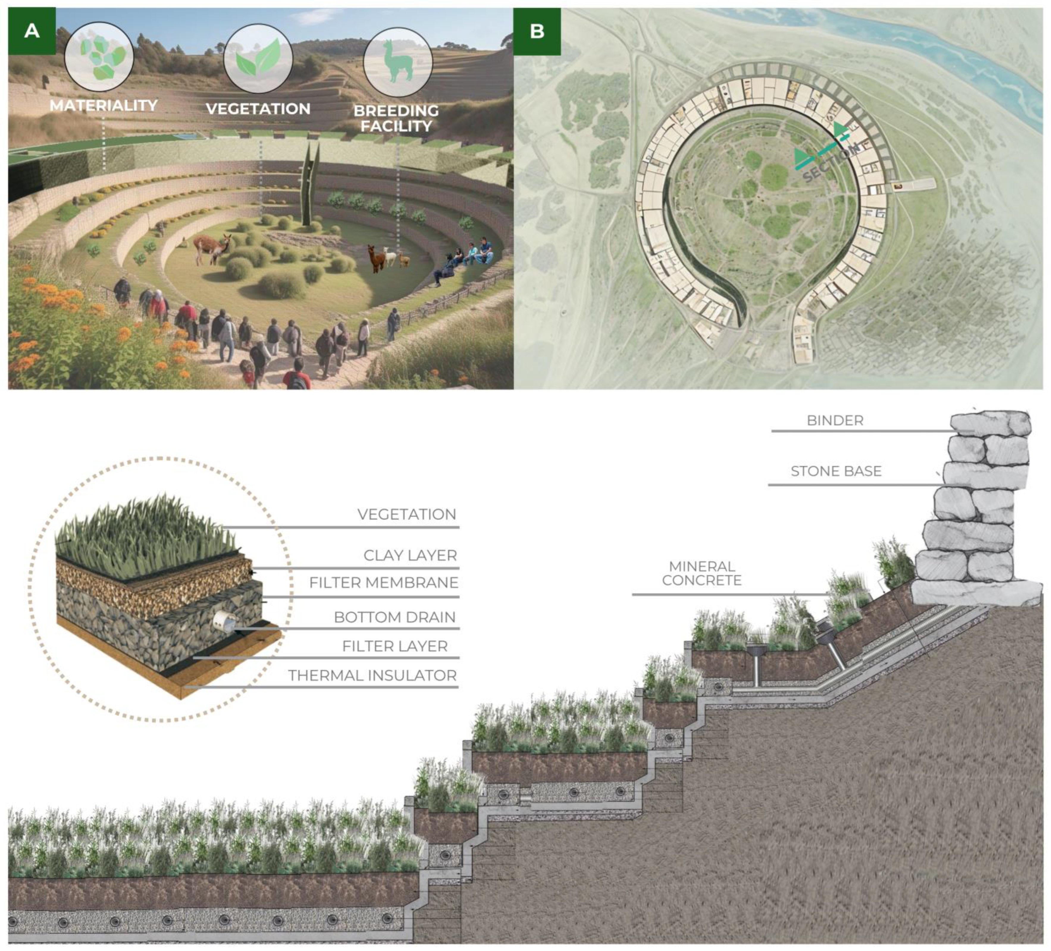
The Center for Cultural Diffusion integrates harmoniously with nature through the use of green roofs, ecological walls, and spaces dedicated to sustainable agriculture, as shown in Figure 23. The top image shows the building covered with vegetation, with a central area dedicated to cultivation. This agricultural space not only provides food but also contributes to thermal regulation and the integration of the building with the mountainous surroundings.
To preserve and promote the cultural identity and legacy of Ollantaytambo, the design incorporates sustainability criteria and harmony with the natural environment through the use of green walls. Native vegetation will be integrated, using species that require less water and maintenance. Additionally, the ecological irrigation system is based on rainwater harvesting and drip irrigation, thus optimizing water resource use.
At the bottom, the composition of the green roof is detailed, which includes a clay layer, filter membranes, a lower drainage system, and thermal insulation. These elements ensure impermeability, moisture control, and thermal regulation within the building. Furthermore, the green walls will provide greater thermal and acoustic insulation, regulating the indoor temperature and reducing external noise, which will enhance the building’s energy efficiency.
The cross-section shows the structure of the inclined walls, stabilized with mineral concrete and a stone base, allowing for a harmonious integration with the terrain in a sustainable manner. The implementation of green walls in the building will contribute to improving air quality, controlling rainwater runoff, and providing esthetic benefits to the surroundings. This design not only represents a sustainable architectural option but also a proposal in harmony with the landscape and culture of Ollantaytambo.
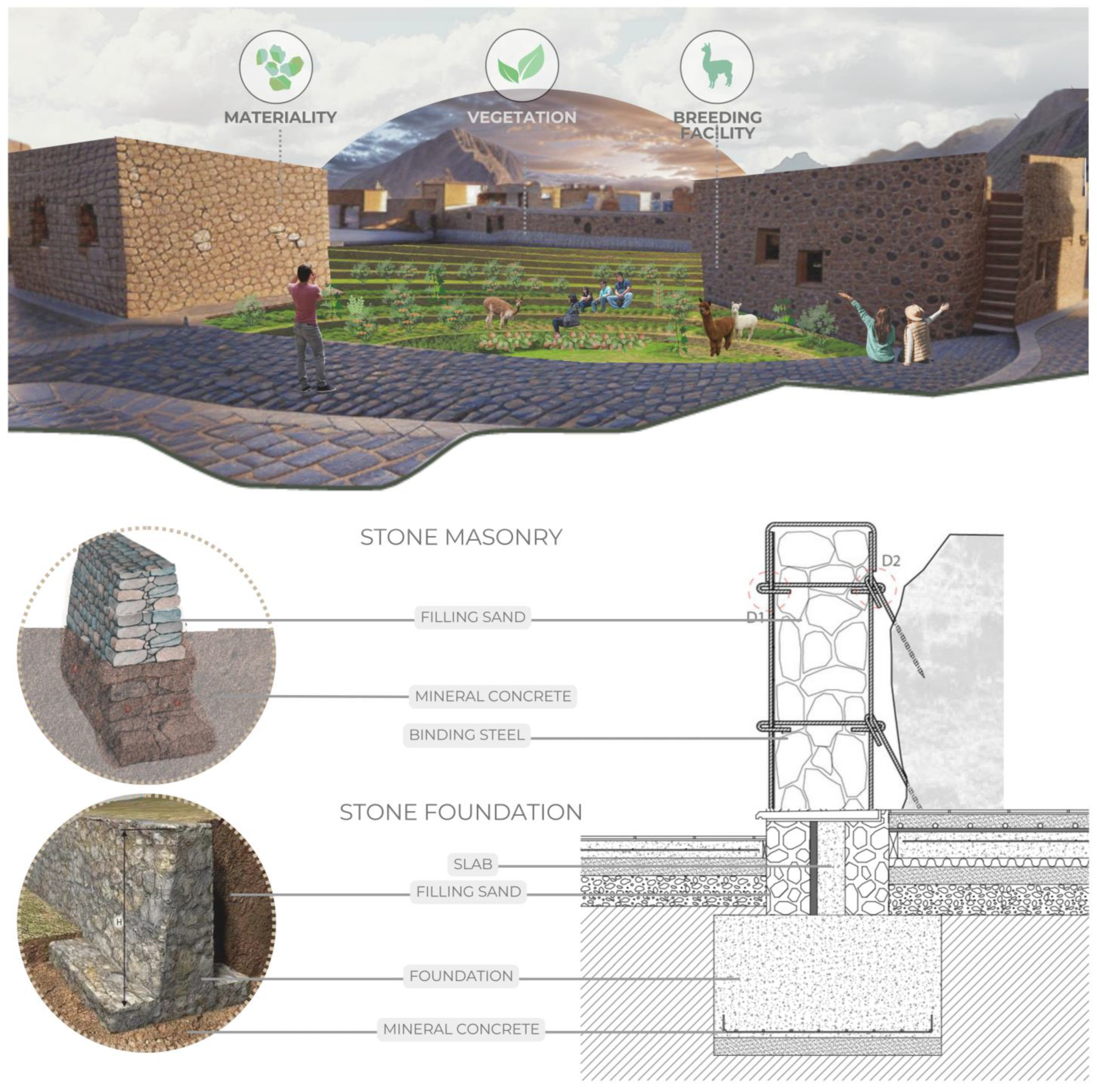
The stone walls are applied not only to preserve and promote the rich cultural heritage of Ollantaytambo but also to foster the conservation of architectural heritage through the use of traditional Inca techniques, as shown in Figure 24. These walls provide a solid and durable structure that harmonizes with the natural surroundings.
In the upper image, the Cultural Diffusion Center, built from stone and harmoniously integrated into the Andean landscape, can be seen. The cobbled paths and terraced green areas evoke the ancestral design of Ollantaytambo, maintaining a balance between architecture and nature.
In the lower section, the construction systems used are detailed. On the left, the “Stone Quarry” diagram shows the composition of the stone walls, where filling sand, mineral concrete, and anchor steel are used to reinforce the structure. On the right, the “Stone Foundation” section illustrates the foundation system of the buildings, which includes a mineral concrete base, filling sand, and a stone support structure.
The use of these materials and traditional techniques not only strengthens the stability and durability of the buildings but also minimizes environmental impact and promotes the sustainable use of local resources. In this way, the preservation of the Inca architectural legacy is ensured, adapting it to contemporary needs without losing its historical and cultural essence.

4. Discussion

Sustainable architecture strategies have been crucial in optimizing thermal comfort, reducing environmental impact, and ensuring energy efficiency across various regions. These solutions stand out for integrating natural materials, utilizing local re-sources, and employing passive climate control systems to reduce reliance on artificial technologies. Moreover, they promote harmony with the landscape and encourage the responsible use of water and energy, ensuring resilient buildings adapted to their environmental context.
The existence of architectural examples such as ACROS Fukuoka, the Vitoria-Gasteiz Congress Palace, and the Cultural Diffusion Center in Ollantaytambo demonstrates the ability to combine sustainability and functionality in architectural design. Each of these projects reflects a distinctive approach to biosustainability, bioconstruction, and bioclimatic design, adapting to the particularities of their environment. Their planning highlights the importance of the relationship between architecture and nature, optimizing the use of available resources and minimizing the ecological footprint.
In terms of biosustainability, ACROS Fukuoka stands out for its integration with the urban ecosystem through its large stepped green roof, which provides thermal insulation and improves air quality [12]. Its terrace structure with over 35,000 plants optimizes rainwater harvesting and mitigates the urban heat island effect in the city. On the other hand, the Vitoria-Gasteiz Congress Palace incorporates a vertical garden with native species, designed to reduce the internal temperature of the building and promote local biodiversity. In the case of the Cultural Diffusion Center in Ollantaytambo, the design takes advantage of native vegetation and rainwater harvesting systems, promoting water self-sufficiency and ensuring a low environmental impact. These projects reflect efficient planning that prioritizes ecosystem conservation and optimal use of natural resources.
From a bioconstruction perspective, the use of local and sustainable materials is a key factor in the durability and efficiency of these buildings. In ACROS Fukuoka, stone and vegetation serve as natural insulators, while in the Vitoria-Gasteiz Congress Palace, the green cladding contributes to regulating the building’s internal temperature. Meanwhile, the Cultural Diffusion Center in Ollantaytambo adopts an approach similar to Inca architecture, using stone walls to preserve cultural identity and enhance structural stability. Additionally, the integration of green walls not only strengthens thermal and acoustic efficiency but also allows for greater integration with the Andean landscape. These elements highlight the importance of adapting construction techniques to local conditions, ensuring resilient, low-impact buildings.
Regarding bioclimatic design, these projects implement passive design strategies to optimize thermal comfort and reduce energy consumption. In ACROS Fukuoka, the vegetation on the facade acts as a natural barrier against solar radiation, minimizing the need for artificial climate control system. In the Vitoria-Gasteiz Congress Palace, the vertical garden improves thermal insulation, reducing the building’s energy de-mand. In the Cultural Diffusion Center in Ollantaytambo, a cross-ventilation system has been integrated, facilitated by the arrangement of internal courtyards and strategic openings that promote natural airflow. Furthermore, the implementation of green roofs with solar panels strengthens the efficient use of resources, combining thermal insulation with renewable energy generation. These strategies help maintain a balance between functionality and sustainability, reducing the environmental impact of the buildings.
Finally, the analysis of these projects reveals how the combination of biosustainability, bioconstruction, and bioclimatics can generate innovative and environmentally respectful buildings. The incorporation of green walls and vegetative roofs contributes to energy efficiency and rainwater harvesting, while the use of natural materials like stone reinforces structural stability and integration with the landscape. These approaches demonstrate that sustainable architecture not only meets functional needs but also plays a fundamental role in environmental conservation and the enhancement of cultural heritage. Thus, projects like ACROS Fukuoka, the Vitoria-Gasteiz Congress Palace, and the Cultural Diffusion Center in Ollantaytambo establish an architectural model that balances tradition and innovation, ensuring a more harmonious and sustainable urban development.

5. Conclusions

The proposal develops comfort strategies that allow users to have direct contact with nature through the Cultural Diffusion Center, promoting a healthier and more pleasant environment. Clean energy strategies are applied, such as the use of photovoltaic panels for natural lighting, taking advantage of the solar radiation from the surroundings and achieving significant economic savings.
Additionally, the proposal includes passive strategies, such as the use of non-polluting materials like stone, thus avoiding the impact of climate change and creating an ideal learning environment that promotes environmental sustainability.
Finally, the use of green roofs and walls, along with the integration of native flora and fauna, not only promotes sustainability and heritage conservation but also enhances the quality of life and the area’s tourist appeal. Furthermore, it contributes to a sustainable and self-sufficient design, protecting the environment, reducing operational costs, and benefiting users with healthier and more efficient spaces.
Nonetheless, the study acknowledges certain limitations, including the absence of empirical field validation and the reliance on digital simulations rather than stakeholder engagement. In addition, contextual factors such as public policy discontinuities, limited access to funding, and institutional bureaucracy may hinder the effective implementation of green infrastructure in heritage sites.
Future research could explore the effectiveness of similar green infrastructure models in other heritage contexts, as well as the socio-environmental impacts of their implementation over time. It would also be valuable to investigate governance strategies and participatory models that could facilitate the long-term maintenance and scalability of sustainable tourism infrastructure in culturally sensitive sites like Ollantaytambo.

Author Contributions

Conceptualization, J.V.C., and A.N.R.C.; methodology, D.E., and J.V.C.; software, C.R.H., C.A.A., R.R.R., and M.V.; validation, D.E., and J.V.C.; formal analysis, C.R.H., C.A.A., R.R.R., and M.V.; investigation, J.V.C., and A.N.R.C.; resources, C.R.H., C.A.A., R.R.R., and M.V.; data curation, J.V.C.; writing—original draft preparation, J.V.C., and A.N.R.C.; writing—review and editing, J.V.C., and A.N.R.C.; visualization, J.V.C., and A.N.R.C.; supervision, D.E., and J.V.C.; project administration, D.E.; funding acquisition, C.R.H., C.A.A., R.R.R., and M.V. All authors have read and agreed to the published version of the manuscript.

Funding

This research received no external funding.

Data Availability Statement

All the data is in the manuscript.

Acknowledgments

We sincerely thank our colleagues for the opportunity to develop an architectural design proposal for green infrastructure intended to enhance eco-tourism at the Ollantaytambo archeological site, located in the Urubamba province, Peru, in 2024.

Conflicts of Interest

The authors declare no conflicts of interest.

References

  1. Huaman, F.; Esenarro, D.; Prado, J.; Vilchez, J.; Vargas, C.; Alfaro, C.; Arriola, C.; Peña, V. Biophysical, spatial, functional, and constructive analysis of the Pre-Hispanic terraces of the ancient city of Pisaq, Cusco, Peru, 2024. Heritage 2024, 7, 6526–6565. [Google Scholar] [CrossRef]
  2. Molano, O. Identidad Cultural un Concepto que Evoluciona. 2007. Available online: https://www.redalyc.org/articulo.oa?id=67500705 (accessed on 20 January 2025).
  3. Miranda, M. Algunas Consideraciones en Torno al Significado de la Tradición. 2005. Available online: https://www.redalyc.org/articulo.oa?id=28150907 (accessed on 20 January 2025).
  4. Saona, E.; Duran, K. Fortalecimiento de la identidad cultural en escuelas rurales. Rev. Arbitr. Interdiscip. Koinonía. 2023, 8, 288–306. [Google Scholar] [CrossRef]
  5. OHCHR. Declaración Universal Sobre la Diversidad Cultural. Available online: https://www.ohchr.org/es/instruments-mechanisms/instruments/universal-declaration-cultural-diversity (accessed on 20 January 2025).
  6. Ministerio de Cultura. Diversidad Cultural, Desarrollo y Cohesión Social. 2014. Available online: https://centroderecursos.cultura.pe/sites/default/files/rb/pdf/Diversidadculturaldesarrolloycohesionsocial.pdf (accessed on 20 January 2025).
  7. Villegas, A. Globalización versus Identidad Cultural: Un conflicto presente. 2017. Available online: https://www.redalyc.org/journal/5709/570960867002/html/ (accessed on 20 January 2025).
  8. Centro del Patrimonio Mundial de la UNESCO. Gestión del Turismo en Sitios del Patrimonio Mundial. 2005. Available online: https://whc.unesco.org/documents/publi_wh_papers_01_es.pdf (accessed on 20 January 2025).
  9. Perales, M.F. Los Iconos Culturales: Un factor Determinante en la Elección del Destino Turístico. 2018. Available online: https://dialnet.unirioja.es/servlet/articulo?codigo=7400821 (accessed on 20 January 2025).
  10. Pezúa, O.R.; Valencia, J.A. Desarrollo Sostenible en Turismo: Una propuesta para Machu Picchu. 2006. Available online: https://www.redalyc.org/articulo.oa?id=360735259003 (accessed on 20 January 2025).
  11. Patrimonio de la Humanidad por la UNESCO. Patrimonio en Piedra. Available online: https://repositorio.usp.br/directbitstream/1b05e689-fb5a-45d6-9570-45beb9e1779a/3036646.pdf (accessed on 20 January 2025).
  12. Al-Kodmany, K. Greenery-Covered Tall Buildings: A review. Buildings 2023, 13, 2362. [Google Scholar] [CrossRef]
  13. Belogolovsky, V. ACROS Fukuoka Prefectural International Hall by Emilio Ambasz Turns 25. Stir World. 1 September 2020. Available online: https://www.stirworld.com/think-columns-acros-fukuoka-prefectural-international-hall-by-emilio-ambasz-turns-25 (accessed on 20 January 2025).
  14. Mompin’s Jardins. Jardín Vertical del Palacio de Congresos de Vitoria-Gasteiz. Visitando Jardines. 8 May 2022. Available online: https://visitandojardines.com/2022/05/08/jardin-vertical-del-palacio-de-congresos-europa-vitoria-gasteiz/ (accessed on 20 January 2025).
  15. UNESCO. Sitios Designados de UNESCO en Perú. 2024. Available online: https://www.unesco.org/es/articles/sitios-designados-de-unesco-en-peru (accessed on 20 January 2025).
  16. Plataforma Del Estado Peruano. Patrimonio Arqueológico. Available online: https://www.gob.pe/institucion/corpac/informes-publicaciones/3612826-patrimonio-arqueologico (accessed on 20 January 2025).
  17. Gonzáles, J. Aprovechamiento Económico de los Recursos Arqueológicos de la Costa Norte del Perú como Alternativa de Crecimiento del Producto Turístico. 2011. Available online: https://tesis.pucp.edu.pe/items/0cb163d5-a05f-4905-9e00-53ba3c95ad25 (accessed on 20 January 2025).
  18. Cordero, L.; Zúñiga, A. Aproximación del Estado del Arte Sobre: Importancia del Valor Patrimonial de Sitios Arqueológicos. 2023. Available online: https://revistas.unan.edu.ni/index.php/Torreon/es/article/view/3005/4508 (accessed on 20 January 2025).
  19. UNESCO World Heritage Centre. Historic Sanctuary of Machu Picchu. 2021. Available online: https://whc.unesco.org/en/list/274/ (accessed on 20 January 2025).
  20. John, P. Ollantaytambo. 2023. Available online: https://www.machu-picchu.org/attractions/ollantaytambo/ (accessed on 20 January 2025).
  21. Mayans, C. Caral, Una Gran Civilización en el Norte de Perú. 2021. Available online: https://historia.nationalgeographic.com.es/a/caral-gran-civilizacion-norte-peru_14823 (accessed on 20 January 2025).
  22. Lr, E. Chan Chan Recibe la Máxima Distinción que se le Otorga a Un Destino Turístico en el Perú. 2024. Available online: https://larepublica.pe/economia/2024/02/20/la-libertad-chan-chan-recibe-la-maxima-distincion-que-se-le-otorga-a-un-destino-turistico-en-el-peru-mincetur-machu-picchu-536960 (accessed on 20 January 2025).
  23. Sequeiros, J. Sacsayhuamán. 2021. Available online: https://diariocorreo.pe/edicion/cusco/templo-de-sacsayhuaman-luce-increible-con-nueva-iluminacion-nocturna-noticia/ (accessed on 20 January 2025).
  24. Plataforma Del Estado Peruano. La Zona Arqueológica Monumental de Kuélap Reabre Sus Puertas con Todas las Medidas de Bioseguridad. 2020. Available online: https://www.gob.pe/institucion/cultura/noticias/313495-la-zona-arqueologica-monumental-de-kuelap-reabre-sus-puertas-con-todas-las-medidas-de-bioseguridad/ (accessed on 20 January 2025).
  25. Áreas Naturales Protegidas en el Perú. 2011. Available online: https://www.minam.gob.pe/wp-content/uploads/2016/06/ANP240516.pdf (accessed on 20 January 2025).
  26. Plataforma Del Estado Peruano. Sistema Nacional de Áreas Naturales Protegidas por el Estado. 2025. Available online: https://www.gob.pe/institucion/sernanp/campa%C3%B1as/4340-sistema-nacional-de-areas-naturales-protegidas-por-el-estado (accessed on 20 January 2025).
  27. Plataforma Del Estado Peruano. Reserva Nacional Pacaya Samiria Recibió Diploma Que lo Ubica en Los Principales Destinos Sostenibles del Mundo. 2021. Available online: https://www.gob.pe/institucion/mincetur/noticias/553583-reserva-nacional-pacaya-samiria-recibio-diploma-que-lo-ubica-en-los-principales-destinos-sostenibles-del-mundo (accessed on 20 January 2025).
  28. Mendieta, P. Reserva Comunal Purús Cumple 19 Años de Creación. 2023. Available online: https://inforegion.pe/reserva-comunal-purus-cumple-19-anos-de-creacion/ (accessed on 20 January 2025).
  29. Gómez, J. Parque Nacional del Manu. 2024. Available online: https://www.globalnationalparks.com/es/peru/manu/ (accessed on 20 January 2025).
  30. Parque Arqueológico de Ollantaytambo. 2024. Available online: https://consultasenlinea.mincetur.gob.pe/fichaInventario/index.aspx?cod_Ficha=938 (accessed on 20 January 2025).
  31. Arquitectura y Construcción Incas en Ollantaytambo. Google Books. Available online: https://books.google.com.pe/books?hl=es&lr=&id=UXrUMxLN_4UC&oi=fnd&pg=PA9&dq=OLLANTAYTAMBO&ots=gmW86U5u5n&sig=iqdkA4dVc1mZKim3yDwi84nvGa0&redir_esc=y#v=onepage&q=OLLANTAYTAMBO&f=false (accessed on 20 January 2025).
  32. Esenarro, D.; Lescano, J.; Chalco, B.; Tapia, N.; Cairo, J.V.; Beltran, C.V.; Arriola, C.; Reyes, R.R. Spatial, Functional, and Constructive analysis of the water resource at the Archaeological Center of Tipon, Cusco, Peru, 2023. Heritage 2024, 7, 6629–6656. [Google Scholar] [CrossRef]
  33. Pierre, J. Arquitectura y Construcción Incas en Ollantaytambo. Fondo Editorial PUCP. Available online: https://www.fondoeditorial.pucp.edu.pe/arte-y-arquitectura/161-arquitectura-y-construccion-incas-en-ollantaytambo.html (accessed on 20 January 2025).
  34. Plan Integral de Gestión Ambiental de Residuos Solidos de la Provincia de Urubamba. 2019. Available online: https://cdn.www.gob.pe/uploads/document/file/3340818/PIGARS%20URUBAMBA%20.pdf (accessed on 20 January 2025).
  35. Hall, S. Who Needs ‘Identity’? In Questions of Cultural Identity; Hall, S., du Gay, P., Eds.; SAGE Publications: Thousand Oaks, CA, USA, 2006; pp. 1–17. [Google Scholar]
  36. Hankir, A.; Bhugra, D. Cultural Psychiatry. In International Encyclopedia of the Social & Behavioral Sciences, 1st ed.; Wright, J.D., Ed.; Elsevier: Amsterdam, The Netherlands, 2015; pp. 471–477. [Google Scholar] [CrossRef]
  37. UNESCO. What is Intangible Cultural Heritage? Available online: https://ich.unesco.org/en/what-is-intangible-heritage-00003 (accessed on 20 January 2025).
  38. Taqa, A.R. The Role of Cultural Heritage in Sustainable Development. ResearchGate. 2025. Available online: https://www.researchgate.net/publication/388869475_The_Role_of_Cultural_Heritage_in_Sustainable_Development (accessed on 20 January 2025).
  39. UNESCO UIS. Conservation of Cultural Heritage. 2024. Available online: https://uis.unesco.org/en/glossary-term/conservation-cultural-heritage (accessed on 20 January 2025).
  40. Vadrucci, M. Sustainable cultural Heritage Conservation: A challenge and an opportunity for the future. Sustainability 2025, 17, 584. [Google Scholar] [CrossRef]
  41. Pan, S.; Gao, M.; Kim, H.; Shah, K.J.; Pei, S.; Chiang, P. Advances and challenges in sustainable tourism toward a green economy. Sci. Total Environ. 2018, 635, 452–469. [Google Scholar] [CrossRef] [PubMed]
  42. Sokolova, M.V.; Fath, B.D.; Grande, U.; Buonocore, E.; Franzese, P.P. The Role of Green Infrastructure in Providing Urban Ecosystem Services: Insights from a Bibliometric Perspective. Land 2024, 13, 1664. [Google Scholar] [CrossRef]
  43. Cuya, N.; Estrada, P.; Esenarro, D.; Vega, V.; Vilchez, J.; Mancilla-Bravo, D.C. Comfort for users of the educational center applying sustainable design strategies, Carabayllo-Peru-2023. Buildings 2024, 14, 2143. [Google Scholar] [CrossRef]
  44. Esenarro, D.; Vilchez, J.; Adrianzen, M.; Raymundo, V.; Gómez, A.; Cobeñas, P. Management Techniques of Ancestral Hydraulic Systems, Nasca, Peru; Marrakech, Morocco; and Tabriz, Iran in Different Civilizations with Arid Climates. Water 2023, 15, 3407. [Google Scholar] [CrossRef]
  45. Garcia, P. Patrimonio arqueológico, puesta en valor y restauración en Ollantaytambo. Anthropologica 2022, 40, 255–285. [Google Scholar] [CrossRef]
  46. Google Earth. Available online: https://earth.google.com/web/search/Urubamba+provincia/@-13.24737844,-72.22463225,3610.62518645a,85227.64484296d,35y,-0h,0t,0r/data=CoEBGlMSTQolMHg5MTZkZTgwZjMxNmNmOTc1OjB4ZjQ0YjkxNjllMDJjMDVkYxmQTIdOz3cqwCFcj8L1KBJSwCoSVXJ1YmFtYmEgcHJvdmluY2lhGAIgASImCiQJsCoff9xZKsAR1gYEWI28KsAZve6OFBf-UcAhDXcUW6AMUsBCAggBOgMKATBCAggASg0I____________ARAA (accessed on 20 January 2025).
  47. Senamhi–Estaciones. Gob.pe. Available online: https://www.senamhi.gob.pe/?&p=estaciones (accessed on 20 January 2025).
  48. SENAMHI—Monitoreo Urubamba. Gob.pe. Available online: https://www.senamhi.gob.pe/?p=monitoreo-urubamba (accessed on 20 January 2025).
  49. Datos Climáticos y Meteorológicos Históricos Simulados para Ollantaytambo. Meteoblue. Available online: https://www.meteoblue.com/es/tiempo/historyclimate/climatemodelled/ollantaytambo_per%c3%ba_3934055 (accessed on 20 January 2025).
  50. Cacciuttolo, C.; Guardia, X.; Villicaña, E. Implementation of Renewable Energy from Solar Photovoltaic (PV) Facilities in Peru: A Promising Sustainable Future. Sustainability 2024, 16, 4388. [Google Scholar] [CrossRef]
  51. Andino Delqñ, S. Plan de Manejo. Gob.pe. 2021. Available online: https://transparencia.cultura.gob.pe/sites/default/files/transparencia/2020/10/resoluciones-ministeriales/rm263-2020-dm-mc-anexo.pdf (accessed on 20 January 2025).
  52. Google Earth. Ollantaytambo. Available online: https://earth.google.com/web/search/Ollantaytambo/@-13.25754154,-72.27101307,2823.2518716a,13275.98651011d,35y,0h,0t,0r/data=CiwiJgokCaJIQE6WMzRAEZ5IQE6WMzTAGaB5TsnXbElAIaJ5TsnXbEnAQgIIATIpCicKJQohMXNYSmxSREhHZEZEOVZyakNka1l5Z3BqUy1MODJ0eFpBIAE6AwoBMEICCABKCAix6o_HARAB (accessed on 20 January 2025).
  53. PDU. Ol Jerarquia Vial.calameo.com. Available online: https://www.calameo.com/read/0043208081a7759e6bcf7 (accessed on 20 January 2025).
  54. INDECI; PNUD. Mapa de Peligro Geológico de la Ciudad de Ollantaytambo, Cusco. Available online: https://sigrid.cenepred.gob.pe/sigridv3/documento/4298 (accessed on 20 January 2025).
  55. Solar Panel Peru. Panel Solar 550W 24v Monocrystalline PERC ECO GREEN. Available online: https://www.panelsolarperu.com/productos/507-panel-solar-550w-24v-monocristalino-perc-eco-green.html (accessed on 20 January 2025).
  56. Vargas, D.E.; Vega, D.J.A.; Cairo, J.V.; Mavila, M.F.V.; Martinez, V.O.R.; Medina, A.G.S. Structural System in Wood and Its Impact on Environmental Design in the Surfer Bungalow in Canoas, Tumbes, Peru. In Proceedings of the 8th ASRES International Conference on Intelligent Technologies ICIT 2023, Jakarta, Indonesia, 15–17 December 2023. [Google Scholar] [CrossRef]
  57. Luminaria Solar 8000lm Bluesmart Exterior Integrado con Sensor de Movimiento. Panel Solar Peru. Available online: https://www.panelsolarperu.com/alumbrado-publico-solar/386-luminaria-solar-8000lm-bluesmart-exterior-integrado-con-sensor-de-movimiento.html (accessed on 20 January 2025).
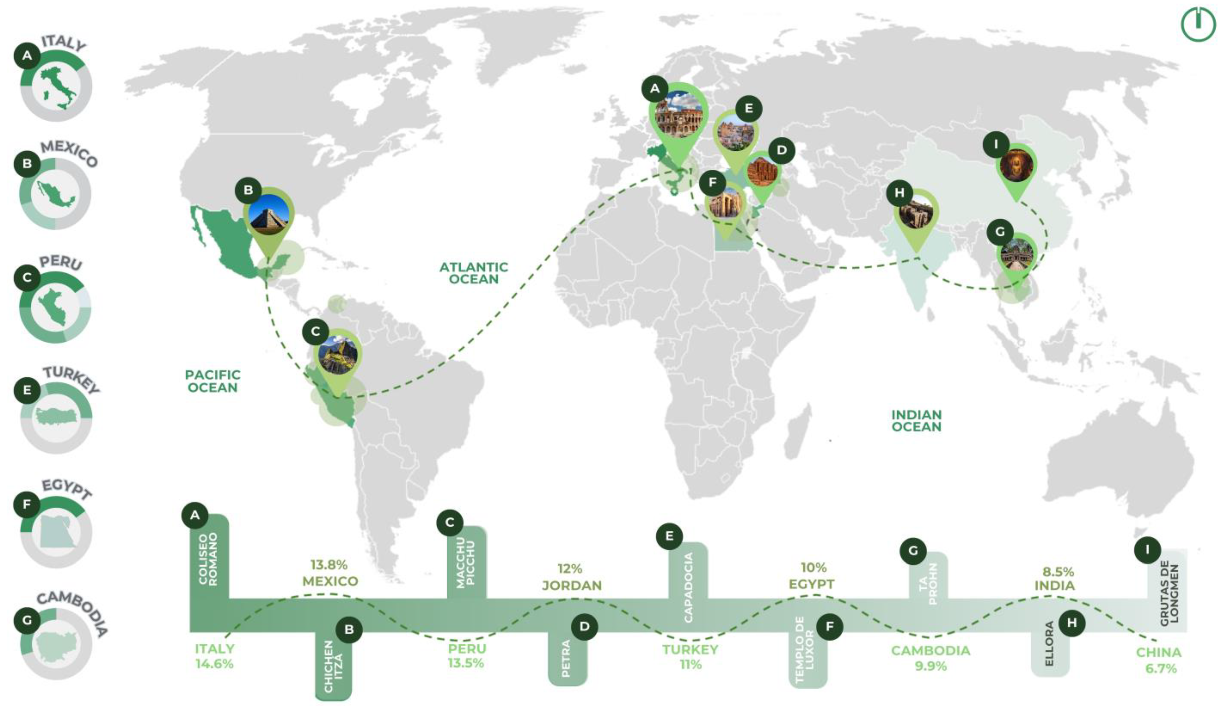
Figure 1. Percentage classification of the archeological sites. (A) Italy; (B) Mexico; (C) Peru; (D) Jordan; (E) Turkey; (F) Egypt; (G) Cambodia; (H) India and (I) China. Figure created by the authors using Adobe Photoshop 2024.
Urbansci 09 00317 g001
Figure 2. (A) ACROS Fukuoka Prefectural International Hall, image courtesy of Emilio Ambasz; adapted with permission from Ref. [13]. 2020, Belogolovsky, V.; and (B) Conference Center in Vitoria-Gasteiz, adapted with permission from Ref. [14]. 2022, Visitando Jardines. Figure created by the authors using Adobe Photoshop 2024.
Urbansci 09 00317 g002
Figure 4. Protected natural areas in Peru. (A) Pacaya Samira, adapted with permission from Ref. [27]. 2020, Plataforma del Estado Peruano; (B) Machu Picchu, adapted with permission from Ref. [19]. 2021, UNESCO; (C) Purus, adapted with permission from Ref. [28]. 2023, Mendieta, P.; and (D) Manu, adapted with permission from Ref. [29]. 2024, Gómez, J. Figure created by the authors using Adobe Photoshop 2024.
Urbansci 09 00317 g004
Figure 5. Images of Ollantaytambo. Photographs taken by the authors using a digital camera.
Urbansci 09 00317 g005
Figure 6. Problems in Ollantaytambo. (A) Disordered tourism; (B) Water shortage; (C) Environmental pollution; (D) Loss of cultural identity; (E) Disordered urban development; (F) Limited access to basic services; (G) Citizen insecurity; (H) Degradation of cultural heritage; (I) Social conflicts; and (J) Vulnerability to natural disasters. Photographs taken by the authors using a digital camera.
Urbansci 09 00317 g006
Figure 7. Methodological research process. Figure created by the authors using Adobe Photoshop 2024.
Urbansci 09 00317 g007
Figure 8. Steps for implementing the proposal with digital tools. Figure created by the authors using Adobe Photoshop 2024.
Urbansci 09 00317 g008
Figure 9. Location. (A) Map of Peru; (B) map of the department of Cusco; and (C) map of the province of Urubamba, adapted with permission from Ref. [46]. 2024, Google Maps. Figure created by the authors using Adobe Photoshop 2024.
Urbansci 09 00317 g009
Figure 10. Climatological analysis of Ollantaytambo. (A) Temperature; (B) humidity; (C) precipitation; and (D) winds. Figure created by the authors using Adobe Photoshop 2024.
Urbansci 09 00317 g010
Figure 11. (A) Flora and (B) fauna of Ollantaytambo. Figure created by the authors using Adobe Photoshop 2024.
Urbansci 09 00317 g011
Figure 12. (A) Map of Urubamba Province; (B) map of Ollantaytambo District; and (C) map of the urban area of Ollantaytambo District. Figure created by the authors using SketchUp 2024, Lumion 2024, and Adobe Photoshop 2024.
Urbansci 09 00317 g012
Figure 13. Geotechnical hazard: (A) Green and archeological areas; (B) urban viability; (C) urban fabric; (D) water bodies; and (E) natural hazard zones. Figure created by the authors using AutoCAD 2024 and Adobe Photoshop 2024.
Urbansci 09 00317 g013
Figure 14. Conceptualization. Figure created by the authors using Adobe Photoshop 2024.
Urbansci 09 00317 g014
Figure 15. Master plan. (A) Center for cultural diffusion; (B) camping; (C) lookout; and (D) ecological corridor. Figure created by the authors using AutoCAD 2024 and Adobe Photoshop 2024.
Urbansci 09 00317 g015
Figure 16. Master plan. Figure created by the authors using SketchUp 2024, Lumion 2024, and Adobe Photoshop 2024.
Urbansci 09 00317 g016
Figure 17. Camping areas. (A) Perspective view of the camping modules integrating green roofs and photovoltaic panels in a rural Andean context; (B) Site plan showing the distribution of camping modules within the landscape; and (C) Sectional diagrams illustrating green roof and photovoltaic panel implementation. Figure created by the authors using SketchUp 2024, Lumion 2024, and Adobe Photoshop 2024.
Urbansci 09 00317 g017
Figure 18. Lookout—green roof. Figure created by the authors using SketchUp 2024, Lumion 2024, and Adobe Photoshop 2024.
Urbansci 09 00317 g018
Figure 19. Ecological corridor—rainwater-harvesting system. Figure created by the authors using SketchUp 2024, Lumion 2024, and Adobe Photoshop 2024.
Urbansci 09 00317 g019
Figure 20. Ecological corridor—solar public lighting. Figure created by the authors using SketchUp 2024, Lumion 2024, and Adobe Photoshop 2024.
Urbansci 09 00317 g020
Figure 21. Center for Cultural Diffusion. (A) Master plan with circular layout and zoning; (B) Perspective of breeding and vegetation areas; (C) Aerial view of ecological integration; and (D) Sections showing courtyards, cultivation, and ecological roof. Figure created by the authors using SketchUp 2024, Lumion 2024, and Adobe Photoshop 2024.
Urbansci 09 00317 g021
Figure 22. Exploded axonometric view of construction systems for the Center for Cultural Diffusion. Figure created by the authors using AutoCAD 2024, SketchUp 2024, Lumion 2024, and Adobe Photoshop 2024.
Urbansci 09 00317 g022
Figure 23. Center for Cultural Diffusion. (A) Materiality, Vegetation, and Breeding Facility; and (B) Section A–A′. Figure created by the authors using SketchUp 2024, Lumion 2024, and Adobe Photoshop 2024.
Urbansci 09 00317 g023
Figure 24. Center for Cultural Diffusion: Stone Masonry and Foundation Construction Details. Figure created by the authors using AutoCAD 2024, SketchUp 2024, Lumion 2024, and Adobe Photoshop 2024.
Urbansci 09 00317 g024
Table 1. Characteristics of the selected solar panel [55].
ManufacturerCityCountryDistributorDimensions (mm)Peak Power (W)Efficiency (%)
Solar Panel 550 W 24 V
Monocrystalline
EcoGreen
Energy
Champs-sur-MarneFrancePanel Solar
Peru
2102 mm × 1040 mm × 35 mm55020.58
Table 2. Maximum electrical demand calculation.
DeviceQuantityLoad (W)Installed Power
(W)
Diversity Factor (D.F)Max. Demand (W)
Lighting28205601560
Emergency lights7642142
Standard Outlets1416222680.81814.4
Computer Outlet720014000.81120
Wi-Fi Outlet120200.816
Total (W):3552.4
Table 3. Electrical energy demand in the camping areas.
Total (W)Total (kW)Days per MonthHours per DayMonthly Energy
(kWh)
Annual Energy
(kWh)
3552.43.552415241278.86415,346.368
Table 4. Solar panel production in the camping areas.
Power per Panel (kW)Daily Solar Radiation (kWh/m2/Day)Efficiency (%)#PanelsDays per MonthMonthly Production (kWh)Annual Monthly Production (kWh)
Solar Panel0.556.020 (0.2)6530128715,444
Table 5. Monthly and annual energy supply by source in the camping areas.
SourceMonthly Energy Supplied (kWh)Annual Energy Supplied (kWh)
Electrical Grid1278.86415,346.368
Solar Panel128715,444
Table 6. Characteristics of public lighting solar panels [57].
ManufacturerCityCountryDistributorDimensions (mm)Peak Power (W)Efficiency (%)
FP Series Street Garden Lights with Motion SensorObluesmartShenzhenChinaPanel Solar
Peru
765 mm × 665 mm × 30 mm8020
Table 7. Solar panel production for public lighting.
Power per Panel (kW)Daily Solar
Radiation (kWh/m2/Day)
Efficiency (%)#PanelsDays per MonthMonthly
Energy
(kWh)
Annual Monthly
Production (kWh)
Solar Street Panel0.086.020 (0.2)303086.41036.8
Table 8. Characteristics of the selected solar panel [55].
ManufacturerCityCountryDistributorDimensions (mm)Peak Power (W)Efficiency (%)
Solar Panel 550 W 24 V
Monocrystalline
EcoGreen
Energy
Champs-sur-MarneFrancePanel Solar
Peru
2102 mm × 1040 mm × 35 mm55020.58
Table 9. Maximum electrical demand calculation.
DeviceQuantityLoad (W)Installed Power
(W)
Diversity Factor (D.F)Max. Demand (W)
Lighting11020220012200
Emergency lights2061201120
Standard Outlets2816245360.83628.8
Computer Outlet1020020000.81600
Wi-Fi Outlet220400.832
Total (W)7580.8
Table 10. Electrical energy demand in the Center for Cultural Diffusion.
Total (W)Total (kW)Days per MonthHours per DayMonthly Energy
(kWh)
Annual Energy
(kWh)
7580.87.580830245458.17665,498.112
Table 11. Solar panel production in the Center For Cultural Diffusion.
Power per Panel (kW)Daily Solar
Radiation (kWh/m2/Day)
Efficiency (%)#PanelsDays per MonthMonthly
Production (kWh)
Annual Monthly
Production (kWh)
Solar Panel0.556.020 (0.2)276305464.865,577.6
Table 12. Monthly and annual energy supply by source in the Center for Cultural Diffusion.
SourceMonthly Energy Supplied (kWh)Annual Energy Supplied (kWh)
Electrical Grid5458.17665,498.112
Solar Panel5464.865,577.6
Disclaimer/Publisher’s Note: The statements, opinions and data contained in all publications are solely those of the individual author(s) and contributor(s) and not of MDPI and/or the editor(s). MDPI and/or the editor(s) disclaim responsibility for any injury to people or property resulting from any ideas, methods, instructions or products referred to in the content.