Article

Coping with Floods in Pikine, Senegal: An Exploration of Household Impacts and Prevention Efforts

1
Department of Earth Science, Utah Valley University, Orem, UT 84058, USA
2
Department of Geography, Kent State University at Salem, Salem, OH 44460, USA
3
Global Change Ecology Program, University of Bayreuth, 95447 Bayreuth, Germany
4
Department of Geography, Kent State University, Kent, OH 44242, USA
*
Author to whom correspondence should be addressed.
Urban Sci. 2019, 3(2), 54; https://doi.org/10.3390/urbansci3020054
Submission received: 9 February 2019 / Revised: 9 May 2019 / Accepted: 15 May 2019 / Published: 18 May 2019
(This article belongs to the Special Issue Urban Disaster and Recovery)

Abstract

:
African cities are at increasing risk for disasters, including floods. Pikine, Senegal—located on the outskirts of the Dakar metropolitan region—has experienced regular floods since 2005 due to a rising water table, dense settlement, and inadequate drainage. The goal of this research was to assess household experiences of floods through in-depth qualitative interviews in one area of Pikine. A total of 44 households were interviewed on the economic and health impacts of flooding and their perceptions of flood mitigation strategies. Our research confirmed that floods create substantial economic and health burdens for families and that infrastructure projects have helped, but not solved, the flooding issues. Our research also had some unexpected findings, particularly relating to concerns over drinking water, land tenure and housing prices, and perception of government intervention.

1. Introduction

In 2005, the Dakar metropolitan region received its highest rainfall in nearly 20 years, and widespread flooding occurred across much of the region. In Pikine, a city in suburban Dakar with nearly 1.2 million residents, the floods displaced thousands of people and cost billions of francs to clean up [1]. Since then, approximately one-third of Pikine’s population has been regularly impacted by flooding, including people living in areas that did not previously flood [2].
Floods are the most common type of natural disaster in the world and affect millions of people each year [3,4,5]. Climate change will contribute to increases in both intensity and frequency of floods and in the damages they cause [3,5]. Yet, these projected changes are complex. Many, but not all, regions will likely see more frequent floods, and the flood season may be earlier in some regions but later in others [6,7,8,9]. Likewise, any projected changes cannot be explained solely by changes in precipitation, since flood characteristics are strongly dependent on the geographic context [6,8]. The models used to predict future flood risk and frequency do not always find the same outcomes and do not take into account any potential mitigation measures [6]. In fact, these projections may be overly pessimistic about human impacts and too optimistic about their reliability [10]. Still, climate change will impact future flooding even if the magnitude is unclear.
In many countries, flood vulnerability will increase because of population growth and spatial expansion [11]. Between 1970 and 2010, the value of assets and the population exposed to flooding increased substantially, with the largest increase in exposed population occurring in Sub-Saharan Africa [4]. Furthermore, it is Sub-Saharan African cities that are at increasing vulnerability to flooding [12]. They are also predicted to experience some of the most severe impacts from these disasters, partly because their residents have low levels of adaptive capacity and they often lack the resources and tools needed to prevent their homes from flooding [13].
Floods disproportionately affect the poorest urban residents, especially those living in informal settlements [14]. As Sub-Saharan Africa’s cities continue to experience rapid population growth, more people are now vulnerable to flooding and other natural hazards. This vulnerability can be attributed to a colonial history of inequality, environmental deterioration, changes in local land use, rapid urbanization, and global patterns of climate change [12,14]. Rapid urbanization, in particular, affects flooding both by obstructing natural drainage patterns and by leading to large populations living on floodplains [14]. Pikine, Senegal, is one such vulnerable city.
Flooding in Pikine has been extensively studied, particularly in terms of governance [15,16,17,18], contamination of groundwater [16,17,19,20], economic impacts [18,21,22], and health concerns [2,23]. Building on this previous work, this study makes three important contributions to the literature. One contribution concerns the perceived effectiveness of government interventions. Since the construction of flood catchment basin infrastructure projects, little research has investigated the impact of this infrastructure on flood control and health. This research fills an important gap in assessing how flood infrastructure may reduce households’ perceived vulnerability. A second contribution concerns the role that land tenure plays in household decisions to remain in flood-prone areas. Although Pikine began as an informal settlement, many households do have formal land rights today. The third contribution of this paper is the finding that households did not attribute health issues to environmental quality but rather drinking water, despite important environmental risk factors present across the commune.
This paper examines flooding impacts at the household level in one commune within the city of Pikine: the Djida Thiaroye Kao Communue. The 16 Communes that constitute Pikine are among the most densely populated areas of Senegal [18]. This project seeks to understand the experience of people living in flood-prone areas and their relationship to infrastructure through the following four research questions: (1) How frequently do floods occur, and how has this frequency changed over time? (2) How is the economic resilience of households impacted by flooding? (3) How is the health of household members impacted by flooding? and (4) How have government interventions affected flooding? The paper first outlines the general development in Pikine and then overviews the literature on flooding impacts. We then present and discuss the results of our interviews to understand how vulnerable residents in Djida Thiaroye Kao cope with the impacts of this regular flooding and explore whether governmental projects have provided any relief to the flooding that has plagued them for over a decade.

1.1. Urban and Economic Development of Pikine

Africa’s informal settlements are sometimes described as unruly, an image that ignores their creativity and ingenuity and instead focuses on their unplanned layout [24]. Yet, this description of unruliness presents the opportunity for their residents to be blamed for any problems. In Pikine, certainly the lack of planning contributes to flooding, but it is necessary to understand the historical context of its urban development. Suburban Pikine is intimately linked to colonial and post-colonial Dakar. Dakar was the showcase city of colonial French West Africa and served as an important economic, political, and cultural hub. Furthermore, its development was largely a story of order through displacement. Indigenous residents were first displaced from the tip of the Dakar peninsula and subsequently pushed further away to the outskirts of the city [25,26]. Pikine is a product of this displacement and is located about 10 km from central Dakar.
Pikine was founded in 1952 as part of the French clearing out of squatter settlements in central Dakar [27]. Much of it was settled through informal urbanization processes in the 1970s and 1980s [17]. This urbanization was unplanned and occurred relatively quickly, and thus networked services such as water and sewerage were not established prior to settlement. These immigrants were generally people leaving the countryside because of environmental and economic factors. New settlement waves were particularly common during drought years, as people in rural areas were faced with dwindling agricultural returns and increasing costs of living, especially in the 1980s [28]. When migrants came to Pikine, they often settled in areas that were formerly wetlands but had turned into dry patches suitable for settlement [29]. The 1970s and 1980s were relatively dry climatic periods in Senegal, so the low-lying areas that constitute much of Pikine were dry, and water tables were below average depths [17]. As ground cover has changed from wetland or vegetation to densely populated, largely unplanned settlements, soil compaction and drainage have become major issues in the region. Land cover in Pikine today is dominated by bare soil and built landscapes, with little vegetation to enable infiltration of water to the soil [18].
This lack of natural drainage and infiltration is exacerbated by the lack of infrastructure to facilitate the evacuation of surface water [16,18]. So far, although some networked infrastructure is under construction, the largest infrastructure project is the construction of catchment basins across Pikine city. These basins, four of which exist in the Djida Thiaroye Kao Commune, were placed in low-lying areas of the commune as a collection point for various surface waters which naturally flow to the lowest areas [16]. Before the construction of the basins, these areas were some of the worst flooded neighborhoods, and thus the houses were razed, and basins created in their place. These basins have alleviated some, but certainly not all, of the localized flooding, and they have created a host of other problems that are described in the results and discussion sections.
Compounding issues from the lack of drainage are the impacts from rising water tables. Most of the population in Pikine, and Djida Thiaroye Kao in particular, use latrines or septic tank toilet facilities because of the lack of a networked, piped sewerage system. Some of this sewage is transported out to the ocean via trucks, but much of the waste filters through the soil locally and both contributes to the rising groundwater levels and potentially contaminates this water. As water tables have risen, sewage levels in septic tanks and latrines have also risen. Households then find their latrines or pits full and dig other holes nearby in which they can dispose of this waste. Disposal of household wastewater also poses a problem for most residents. The most common way to dispose of waste is to use public streets or alleyways as wastewater disposal sites, with the water infiltrating the soil or evaporating at the surface. Households that live close to water catchment basins sometimes dispose of household wastewater directly into the basins.
Another contribution to the rising water tables is the increasing rainfall regimes since the time of initial settlement [17]. As stated earlier, most of Pikine was settled during periods of prolonged drought. The low-lying areas that make up most of the city had much lower water tables at the time of settlement than the long-term average water table depths. Rainfall patterns returned to normal during much of the 1990s, and water tables rose and returned to a more average depth. Flooding did not immediately accompany this return to normal rainfall and water table levels but instead began after rainfall increased significantly in 2005. In fact, from 1970 until 2005, Dakar experienced some of its lowest recorded rainfall levels, but since then, they have remained high with intense periods that cause heavy flooding [2].
Rising water tables and the lack of sanitation have contributed to the severe contamination of the Thiaroye Aquifer which underlies most of Pikine [30]. This aquifer was the source of Dakar’s drinking water until the mid-2000s, but high levels of nitrates, caused primarily by the infiltration of wastewater, made the aquifer’s water too expensive to treat and deliver [19]. Dakar’s networked water system stopped using the Thiaroye Aquifer, and all the water that was once pumped out now remains in place. The ever-growing population of the region, coupled with climate change-induced patterns of erratic rainfall regimes and the ceasing of use of the underground aquifer, has made flooding a recurrent and often catastrophic problem [16,30,31]. Previous research has demonstrated that severe contamination continues at wells and boreholes across the city of Pikine and the Commune of Djida Thiaroye Kao, and this groundwater often makes its way to the surface during flooding periods [16,17,19,20]. The impacts of contaminated water are but one of the many economic and health impacts of flooding in the region.
Not only does Pikine suffer from development and environmental problems that contribute to flooding, it also faces economic and social challenges. In 2005, just as increased rainfalls were causing regular flooding, Senegal’s poverty reduction efforts stalled [32]. The floods themselves are one explanation for this decline in economic growth. A 2011 survey found that 25% of people in Pikine do not have their nutritional needs met, 78% live in households that are deprived of basic needs such as water, electricity, sanitation, or proper construction, and 33% are considered to live in poverty [32]. Compared to other cities in Senegal, Pikine is ranked last in terms of the number of homes with running water, with toilets connected to the sewer system, and with electricity [33]. Although the entire Dakar region experiences floods, they are more severe and affect more people in Pikine than in other areas. Thus, many of the residents of Pikine lack the financial resources to both prepare for and recover from floods.

1.2. Overview of Flood Impacts in the Dakar Metropolitan Region

Floods create significant economic impacts by damaging homes and possessions, increasing economic vulnerability, and forcing people to spend time on flood prevention or clean-up rather than on income-generating activities [2]. People may also forgo medical treatment because of a lack of ability to pay for service [21]. Poverty has been linked to the difficulty for households to implement long-term strategies for flood mitigation [18]. Instead, residents implement short-term strategies such as building a small wall in front of their house or using sandbags to create flood barriers [18]. They end up spending more money over time on these short-term measures because they need immediate relief rather than saving for a more effective and expensive permanent solution. These residents are often unable—or unwilling—to move to areas free from flooding because these new places might be further from work or too small for Dakar’s typically large families [34]. Thus, the city’s poor are stuck in a flooding cycle. They stay in these flood-prone areas to be close to work, but then the floods disrupt transportation and mobility, and residents lose income [18]. Compounding these problems is the fact that Dakar lacks adequate flooding and greywater infrastructure. Only 7% of households in Dakar have storm water drainage outside their home, and only 5% of those drains actually work [22].
The expected increase in the intensity and frequency of floods will then increase both disease and mortality rates [3]. The most commonly associated disease with flooding is malaria, and its infection rate increases during flooding periods because mosquitoes breed in standing and stagnant water [21,35]. Disease risk can persist even after floods recede, since mosquito eggs can survive on damp soil for several days, and transmission increases as the proximity to breeding grounds decreases [36]. In Pikine, studies found that malaria affects 93% of households [2] and, in another suburban city of Dakar, it affected nearly half of all patients seen at a health center [37]. Floods lead to standing water which can also contribute to skin disease. This is especially true when skin is submerged in contaminated flood water for a prolonged period of time [38].
Floods can contaminate drinking water sources and cause diarrhea, which is the leading cause of morbidity and mortality in children under the age of five in the developing world [39,40]. In Pikine, diarrhea is more common in households that experience flooding [2], and in urban Senegal, more broadly, bacterial diarrhea is most prevalent during the rainy season [23]. In addition to contaminating drinking supplies, flood water can disrupt sewerage systems [41] and prevent people from seeking medical services by flooding healthcare facilities [21].

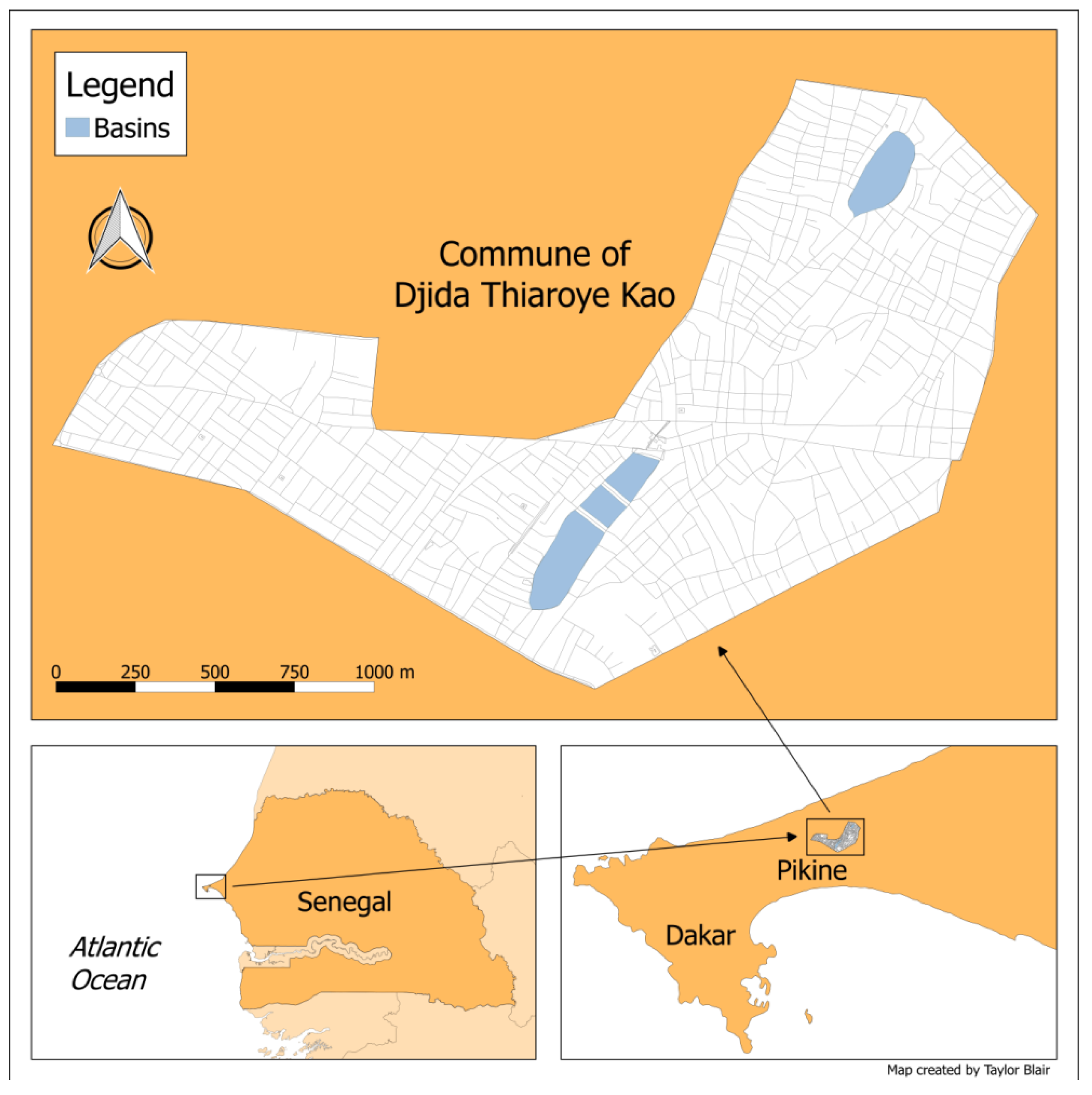
2. Study Site and Methods

A research team administered 44 household interviews in the Djida Thiaroye Kao Commune of Pikine. Its population is estimated at 90,000 people. The boundaries of Pikine and the boundaries of the Djida Thiaroye Kao commune, along with the locations of the flood catchment basins, are shown in Figure 1. The research team consisted of American students and professors as well as members of the Environmental Commission of the Djida Thiaroye Kao Mayor’s Office. The goal of this research was not a statistical analysis of flooding and population, but rather, a deep exploration of households’ perceived experiences across a wide range of neighborhoods in one commune. Convenience sampling was thus used to identify households, although households at varying distances from the drainage basins were targeted to obtain spatial coverage of the commune. No households that were approached by the research team declined to participate in this study. Once saturation was reached, interviews were concluded. The themes that arose from these households can be used to gain some conceptual generalizations about household adaptation to flooding in this particular context.
The household interviews were administered by a student or professor member of the research team with the assistance of a translator. Members of the Environmental Commission participated in about half of the interviews. Although it is possible that having a member of the commission present for some interviews might have skewed the results, we do not believe this was the case. Instead, since the commission members are elected by commune residents, we believe that participants were likely to be honest in their responses because they thought these elected members could either fix their problems or communicate them to someone who could.
Questions were asked by the local translator in Wolof, the most widely spoken language in Senegal. Answers were then translated into English or French on the basis of the researcher’s language proficiency. The interviews were semi-structured and included questions around four themes: (1) flooding frequency and temporal changes; (2) economic costs from floods; (3) health impacts from floods; and (4) catchment basins and other flood-related government interventions. In addition, the interviews asked general demographic questions including on tenure, water access, and electricity access. All interviews asked these same standard questions while allowing for follow-up questions as needed. Interviews took place directly at respondents’ homes and generally lasted about 30 min. All respondents were heads of households and over age 18; 27 were women, and 17 were men. This project received research and ethical approval from the researchers’ universities in the United States and permission from the Djida Thiaroye Kao Mayor’s Office and the Higher Education Administration in Senegal.

3. Results

The following sections present the interview results for this project’s four research questions. Table 1 provides a summary of the main findings. Results are presented as percentages of interviewed households. Given the small sample and exploratory nature of this project, these results should be interpreted as illustrative descriptions of the flooding-related challenges in Pikine, Senegal.

3.1. Flooding Frequency

Floods occur with frequency in Djida Thiaroye Kao. Most of the interviewed households (82%) have experienced flooding at some point during their tenure. Only one specific reason for never experiencing a flood was offered: that the respondent was new to the commune and had not yet lived there during a rainy season. For those households that do experience floods, 69% indicated they occur at least once per year—with some experiencing multiple flooding episodes each year. Additionally, 25% stated that floods occur regularly but not necessarily every year. The remaining households had less frequent experiences. Some of the decreasing frequency of flooding was attributed by respondents to government interventions, and those results are discussed in a later section.

3.2. Flooding and Economic Resilience

Given the literature reviewed previously, the research questions for this project focused on potential economic and health impacts in Djida Thiaroye Kao. During the interview, respondents were asked an open-ended question about what they considered to be the biggest impact of flooding. Although not all offered a clear answer beyond the presence of standing water, the two most common impacts offered were stresses on household finances and increases in illnesses. The interviews identified three types of economic impacts.
First, floods force people to leave their homes, and 45% of households indicated that they had moved because of floods, but land tenure concerns compelled a majority of people to stay in flood-prone areas. Of households that did move, moves included permanent ones such as a respondent moving to this commune from an area even more flood-prone. They also included temporary moves such as to a neighbor’s home or returning to their home village until flooding impacts dissipated. Of households that did not move, most respondents cited land tenure as a reason for staying in flood-prone areas. Having formal land titles and the legal rights that accompany these titles was very important to the residents that chose to stay. Residents explained that land prices across the Dakar metropolitan region were very high, but that they preferred to have their own property rather than rent, so they stayed where they had land titles. Securing land and legal rights was one of the highest priorities for households, and dealing with flooding or other challenges of this land was often a secondary consideration. Two respondents (5%) noted that they did leave Djida Thiaroye Kao because of flooding but ultimately moved back because they owned land there. Of those households that did not move, five (11%) stated explicitly that they wanted to leave but lacked either the money to finance a move or an alternative home. The remaining households prioritized tenure security over flooding risk.
Second, floods impact finances by disrupting the ability of adults to work; in fact, a majority of households (66%) indicated their work was affected at some point by floods. Reasons offered were that the floodwater makes transportation difficult, parents are reluctant to leave their children home alone during floods, they must spend time preventing floods or cleaning up after floods, and that the rains and floods prevent certain types of work such as carpentry. Although not directly linked to economics, 32% of households stated that floods disrupted the ability of children to attend school. Reasons given included losing birth certificates in a flood (thus preventing them from enrolling), flood water ruining children’s school papers and homework, parents not being able to afford tuition, children developing sores on their feet (thus unable to walk to school), and children being sent away from the commune to live with other relatives.
Third, households spend significant amounts of money on flood prevention and coping measures. One of the most common strategies is to backfill, which uses gravel or sand to elevate the interior floor as well as the outside of the home. Over time, this strategy makes the inside of the home uninhabitable, so a new floor must be added to the structure. One household noted that there were three levels of their house below what was currently visible. The process of backfilling is very expensive, which prevents all households from undertaking it. The average annual cost of these efforts was 86,387 West African francs (US$155 at the time of research), which is roughly equal to the average monthly salary in Dakar [42]. Households also used sand and gravel to build barriers, either to fill sandbags or just to create a blockade. In total, over half of the households (55%) purchased either or both of these materials as flood prevention strategies. Another strategy to prevent floods was to dig trenches outside to divert water away from the home, although this was less common and used by just 5% of households. Still, some households took no actions, with 34% indicating that they did nothing to prepare. One respondent commented that his family just had to live in the standing water.
Households also used coping strategies once the floods actually came, which suggests that these preventative measures are not always successful. The most common strategies were to use bricks or other materials to both elevate belongings and create walking paths (27%) and to remove water from interior spaces with pumps, buckets, or pipes (14%). Thus, households must spend money to purchase supplies, including electricity to power the pumps. In particular, households highlighted the need to elevate beds to prevent damage to mattresses and to elevate stoves to allow for cooking during floods. As some households experience flood levels of up to a meter, it is necessary to raise possessions quite high. Unfortunately, these coping efforts are not always successful, and households indicated spending money to replace items damaged by floods including mattresses, furniture, and latrines.

3.3. Flooding and Health

The interviews asked about three specific flood-related health issues. First, respondents were asked to identify those diseases and illnesses associated with flooding. Many households identified multiple diseases and illnesses, and the three most common were malaria (66%), skin diseases (27%), and diarrhea (23%). Second, respondents were asked about the frequency of malaria and skin disease during the past year for all family members living in the household; follow-up questions on diarrhea occurrences focused on causation rather than frequency. Respondents reported frequent illnesses, with 84% of households having at least one family member infected with malaria in the past year; of those, 16% indicated that every member of the household contracted malaria, and two households (5%) saw a family member die from the disease. Skin diseases such as rashes and fungus infections were also common, and 64% of households had at least one family member affected, and 18% had either every household member or every child affected.
For diarrhea cases, the interviews focused on drinking water access. All interviewed households drink tap water from the piped water network, which pumps groundwater, treats it, and pipes it to houses in Pikine and Dakar. Households use a variety of types of tap, including those located at their home, at their neighbor’s homes, and in public spaces. Even though water from these taps is treated, half of all respondents believe that their water is not safe or clean, and another 25% indicated that they are unsure of their water quality. The major complaint with quality was that the water is discolored or has a foul smell. Yet, in spite of quality concerns, most households (66%) do not treat their drinking water. Of the 15% who do treat it, they use chemicals or just let the water sit so that sediment settles; importantly, not all of these households treat their water consistently.
Third, the interviews asked respondents about the ability and willingness to seek medical treatment. Most households seek medical treatment for their flood-related illness, with 64% stating that they always get treatment; this includes both purchasing medicine and making visits to a healthcare facility such as a hospital or private clinic. For the remainder of households that either seek treatment occasionally or never do so, the primary reason offered was economic. Respondents noted that they could not afford treatment and that they prioritized paying for food or water over healthcare. Some households also indicated that they had borrowed money in the past to pay for treatment.

3.4. Effectiveness of Government Interventions

In recognition of the impacts of regular flooding, the Dakar city government has attempted an innovative, if not fully successful, flood control program that involved the construction of water basins. The water basins were a part of the urban planning project called Plan Jaxaay, which relocated people from flood-prone areas alongside efforts to channel storm water into these catchment basins [34]. The first basin in Pikine was built in 2007, and the Djida Thiaroye Kao Commune now has four basins for flood relief and storm water collection [34]. The design included pumps that were to move water from the basins into lake systems and eventually to the Atlantic Ocean, but these plans were not fully realized, and the basins were never fully connected to each other or to the coast [34]. It was also suggested that these basins would have other benefits beyond flood control, such as housing species of birds, plants, and fish [43]. Little research has been done on these basins, however, so little is known about their real or perceived effectiveness.
Given that these basins are very visible in the commune, the interviews asked about their impacts on these households. The majority (82%) reported that the basins helped either themselves or others with flooding, although some noted that the impact was small. Many respondents (64%) noted both a decrease in malaria and a decrease in skin diseases (41%). Still, some of those households that believe the flooding situation has improved express skepticism; they are unsure of how much benefit is directly attributed to the basins, since the area still floods. Furthermore, households both see the basins are helpful for flooding but harmful in other ways; for example, 32% recalled drowning deaths in the basins, and 14% believe they brought more mosquitoes. Although basins have decreased flooding, they do create large bodies of standing water that could increase the number of mosquitoes. In fact, all of the 16% of respondents determined to live close to the basins by the research team identified malaria as their most significant health problem.

4. Discussion

The goal of this research was to gain a deep understanding through qualitative interviews of household experiences of flooding in terms of both frequency and impacts. The majority of residents reported that flooding occurs yearly and is a major concern of living in Djida Thiaroye Kao. Our results broaden the literature on flooding impacts by showing that households experience negative economic and health impacts from flooding and that these impacts are interlinked and tied to environmental quality, land tenure, and inadequate intervention. Most residents reported that coping with flooding required spending money, either on material adaptations to water entering the house or on the treatment of medical ailments. Thus, flooding is a financial burden to most households. Despite flooding being frequent and expensive, residents reported that government interventions and the construction of basin infrastructure has helped alleviate severe flooding and consequences but not fully eliminated them.
Our research had some unexpected findings, particularly relating to concerns over drinking water, land tenure and housing prices, and perception of government intervention. In cities across Sub-Saharan Africa, water access and land tenure status are linked [44]. In Djida Thiaroye Kao, we found that most houses were connected to the formal water distribution network, despite the informal land tenure that characterizes much of Pikine [45]. We did not expect to find that the majority of households have reliable drinking water access, particularly since reports of diarrhea were common. Although households reported having reliable drinking water, they also stated that they did not trust the quality of water coming from their taps. Many households tied their household experiences of diarrhea to questionable drinking water quality. Dakar’s drinking water network (which also serves Pikine), however, is generally assumed to be good and to provide treated water safe for direct consumption [17].
Since most households have access to safe drinking water but still experience episodes of diarrhea, it suggests that the disease may be linked to other environmental factors. Sanitation is perhaps more linked to flooding and health in Djida Thiaroye Kao than drinking water access. This is an important finding, particularly in light of the near absence of solid waste and wastewater infrastructure across the commune and much of the city of Pikine [45]. Observation of sanitation and environmental health risks during our fieldwork helped us understand that other important vectors of diarrhea exist in the commune, including insects (flies and cockroaches), animals (rodents and livestock), and people coming into contact with open-air latrines, open waste disposal sites, and standing water. This is an important result in that it suggests that investment needs to be directed toward sanitation infrastructure, and households need to be educated on environmental health risks.
A second unexpected finding was the impact of land tenure on decisions to stay in flooded areas. Many households reported that, since they had formal land titles for their property, they would deal with whatever flooding occurred. Households reported that finding another plot of land to legally own is expensive and that they are glad to have tenure, despite the constant flooding issues. Land tenure ensures household security and survival, both now and for future generations. Furthermore, land tenure rights across the Dakar metropolitan region are expensive, and residents reported that land prices in Djida Thiaroye Kao were out of reach for most, despite often being classified as an undesirable place to live [32]. This finding suggests that tenure rights are considered essential to many residents, and that moving without guarantee of tenure is undesirable. People are unlikely to leave their homes because of flooding if they have tenure security, so coping with and adapting to floods becomes the only choice.
A third important finding of our study was the perceived role and efficacy of government flood prevention efforts. Households in our study mostly responded that the catchment basins have helped and that they want to see more large infrastructure projects implemented. Residents also reported that, although the basins do lessen the amounts of standing water in some parts of Djida Thiaroye Kao, they have also created a series of other problems especially in terms of health and sanitation. Residents reported that people use the basins to dispose of greywater, trash, soap, and oil, and the flood water itself that drains into these basins can be contaminated with sewage or chemical waste. Some of the basins have even filled in with sediment, creating stagnant water that allows algae and tall grasses to flourish. Sediment from basins is often used to make bricks, and the basin water itself is used to irrigate small agriculture plots. Another negative issue regarding the basins is that they have not fully eliminated flooding. Residents still spend a substantial portion of their incomes on flood prevention and coping. This failure to fully alleviate the flooding problem is not completely unexpected. As Few [46] notes, there are many examples of these types of structural prevention measures being improperly maintained, which can actually exacerbate flood hazards.
Despite the incomplete and inadequate flood relief and a host of other problems that the basins have created, most households reported that they would like to see other infrastructure projects. In particular, households want more and larger canals, new and better roads, and more catchment basins. The national government, however, is embarking on an ambitious plan aimed at using flood water as an economic resource. The “Living with Water” project, for example, promotes community gardens as an effective way of using excess water for economic and community good [47]. In addition to community gardens, the project emphasizes waste collection and improving public space around basins with furniture and leisure grounds. These projects essentially ask communities and people to adapt to the water’s presence and find it beneficial. Residents, however, noted a preference for large infrastructure projects that would clear out water and make their neighborhoods free from flooding. The fact that residents and the government propose different solutions to flooding is not surprising, as each group blames the other for flooding in the first place [48].

5. Conclusions

Djida Thiaroye Kao, and indeed much of Pikine, still experiences regular and devastating floods, and residents cope with heavy economic and health burdens. Much of our research confirmed what previous studies found—that households spend an enormous amount of money coping with flooding, whether directly through home improvements or indirectly through increased medical costs. Along with confirming these past findings, this study makes important new contributions. Our research findings fill an important gap in the literature on how large flood relief infrastructure projects and their efficacy in reducing flood risks are perceived by local populations. Particularly important in this research are the findings that government programs of flood relief have mitigated some flooding issues but have created a host of other problems for residents. These other problems are in turn associated with health problems, particularly diarrhea, because of environmental contamination and practices, which then in turn cost households more money. More research is needed on government interventions in Pikine and, especially, on these basins. Furthermore, households are stuck in Pikine because of housing affordability issues; housing tenure in a flooded area is better than no tenure, even if another area would be less environmentally precarious. The complex role of land tenure—on one hand providing financial stability but, on the other, necessitating significant flood control costs—is another area of future research. Also, residents do not want the responsibility of solving these problems but, rather, would prefer the government to invest in sanitation and wastewater infrastructure.
Flooding in Pikine is getting worse. One-third of Pikine’s 1.2 million residents regularly experience flooding, with a significant portion of these people living in areas that did not previously flood. Economic and health impacts are expected, but these impacts will take new forms as residents continue to shape and change their local spaces, basin infrastructure matures, and institutional arrangements shift over time. This research highlights opportunities for intervention such as environmental health and sanitation measures and education on diarrhea and appropriate sanitation practices. It also raises important questions on tenure security and environmental risk. There is no one solution to flooding in Pikine, and assessments of local experiences with respect to flood risk must continue as long as the threat of flooding persists.

Author Contributions

Project Conceptualization, H.H., S.L.S., and E.C.; Methodology, H.H., S.L.S., and E.C.; Formal Analysis, H.H., S.L.S., T.B., S.B., N.B., and E.C.; Writing—original draft preparation, all authors; Writing—review and editing, H.H. and S.L.S.; Funding acquisition, H.H., S.L.S., and E.C.; Map Creation, T.B.

Funding

This research was funded by Utah Valley University and the Kent State University Research Council.

Acknowledgments

The Djida Thiaroye Kao Environmental Commission provided invaluable assistance in the field.

Conflicts of Interest

The authors declare no conflict of interest.

References

  1. Dartmouth Flood Observatory. 2005 Global Register of Major Flood Events. Available online: http://www.dartmouth.edu/~floods/Archives/2005sum.htm (accessed on 14 August 2018).
  2. Cissé, O.; Sèye, M. Flooding in the suburbs of Dakar: Impacts on the assets and adaptation strategies of households or communities. Environ. Urban. 2016, 28, 183–204. [Google Scholar] [CrossRef]
  3. Alderman, K.; Turner, L.R.; Tong, S. Floods and human health: A systematic review. Environ. Int. 2012, 47, 37–47. [Google Scholar] [CrossRef] [PubMed]
  4. Jongman, B.; Ward, P.J.; Aerts, J.C.J.H. Global exposure to river and coastal flooding: Long term trends and changes. Glob. Environ. Chang. 2012, 22, 823–835. [Google Scholar] [CrossRef]
  5. Wilby, R.; Keenan, R. Adapting to flood risk under climate change. Prog. Phys. Geogr. 2012, 36, 348–378. [Google Scholar] [CrossRef]
  6. Arnell, N.; Gosling, S. The impacts of climate change on river flood risk at the global scale. Clim. Chang. 2016, 134, 387–401. [Google Scholar] [CrossRef]
  7. Blöschl, G.; Hall, J.; Parajka, J.; Perdigão, R.A.; Merz, B.; Arheimer, B.; Aronica, G.T.; Bilibashi, A.; Bonacci, O.; Borga, M.; et al. Changing climate shifts timing of European floods. Science 2017, 357, 588–590. [Google Scholar] [CrossRef] [PubMed]
  8. Hirabayashi, Y.; Kanae, S.; Emori, S.; Oki, T.; Kimoto, M. Global projections of changing risks of floods and droughts in a changing climate. Hydrol. Sci. J. 2008, 53, 754–772. [Google Scholar] [CrossRef]
  9. Hirabayashi, Y.; Mahendran, R.; Koirala, S.; Konoshima, L.; Yamazaki, D.; Watanabe, S.; Kim, H.; Kanae, S. Global flood risk under climate change. Nat. Clim. Chang. 2013, 3, 816–821. [Google Scholar] [CrossRef]
  10. Blöschl, G.; Montanari, A. Climate change impacts—throwing the dice? Hydrol. Process. 2010, 24, 374–381. [Google Scholar]
  11. Kellens, W.; Terpstra, T.; Schelfaut, K.; De Maeyer, P. Perception and communication of flood risks: A literature review. Risk Anal. 2013, 33, 24–49. [Google Scholar] [CrossRef] [PubMed]
  12. Fraser, A.; Leck, H.; Parnell, S.; Pelling, M. Africa’s urban risk and resilience. Int. J. Disaster Risk Red. 2017, 26, 1–6. [Google Scholar] [CrossRef]
  13. Dodman, D.; Leck, H.; Rusca, M.; Colenbrander, S. African urbanisation and urbanism: Implications for risk accumulation and reduction. Int. J. Disaster Risk Red. 2017, 26, 7–15. [Google Scholar] [CrossRef]
  14. Douglas, I.; Alam, K.; Maghenda, M.; McDonnell, Y.; McLean, L.; Campbell, J. Unjust waters: Climate change, flooding and the urban poor in Africa. Environ. Urban. 2008, 20, 187–205. [Google Scholar] [CrossRef]
  15. Bottazzi, P.; Winkler, M.S.; Speranza, C.I. Flood governance for resilience in cities: The historical policy transformations in Dakar’s suburbs. Environ. Sci. Policy 2018, 93, 172–180. [Google Scholar] [CrossRef]
  16. Ndiaye, M.; Traore, V.; Toure, M.; Sambou, A.; Diaw, A.; Beye, A. Detection and ranking of vulnerable areas to urban flooding using GIS and ASMC (spatial analysis multicriteria): A case study in Dakar, Senegal. Int. J. Adv. Eng. Manag. Sci. 2016, 2, 1270–1277. [Google Scholar]
  17. Pfeifer, H.R.; Amiguet, A.; Brandvold, V.; Daouk, S.; Gueye-Girardet, A.; Hitz, C.; Ndiaye, M.L.; Niang, S.; Okuda, T.; Roberts, J.; et al. Water-related risks in the area of Dakar, Senegal: Coastal aquifers exposed to climate change and rapid urban development. In Identifying Emerging Issues in Disaster Risk Reduction, Migration, Climate Change and Sustainable Development; Springer: Cham, Switzerland, 2017; pp. 53–65. [Google Scholar]
  18. Schaer, C. Condemned to live with one’s feet in water? A case study of community based strategies and urban maladaptation in flood prone Pikine/Dakar, Senegal. Int. J. Clim. Chang. Strateg. Manag. 2015, 7, 534–551. [Google Scholar] [CrossRef]
  19. Faye, S.C.; Faye, S.; Wohnlich, S.; Gaye, C.B. An assessment of the risk associated with urban development in the Thiaroye area (Senegal). Environ. Geol. 2004, 45, 312–322. [Google Scholar] [CrossRef]
  20. Re, V.; Faye, S.C.; Faye, A.; Faye, S.; Gaye, C.B.; Sacchi, E.; Zuppi, G.M. Water quality decline in coastal aquifers under anthropic pressure: The case of a suburban area of Dakar (Senegal). Environ. Monit. Assess. 2011, 172, 605–622. [Google Scholar] [CrossRef] [PubMed]
  21. George, P. Health impacts of floods. Prehosp. Disaster Med. 2011, 26, 137. [Google Scholar] [CrossRef]
  22. Gulyani, S.; Bassett, E.M.; Talukdar, D. A tale of two cities: A multi-dimensional portrait of poverty and living conditions in the slums of Dakar and Nairobi. Habitat Int. 2014, 43, 98–107. [Google Scholar] [CrossRef]
  23. Sambe-Ba, B.; Espié, E.; Faye, M.; Timbiné, L.; Sembene, M.; Gassama-Sow, A. Community-acquired diarrhea among children and adults in urban settings in Senegal: Clinical, epidemiological and microbiological aspects. BMC Infect. Dis. 2013, 13, 580. [Google Scholar] [CrossRef] [PubMed]
  24. Myers, G. African Cities: Alternative Visions of Urban Theory and Practice; Zed Books: London, UK, 2011. [Google Scholar]
  25. Bigon, L. Names, norms and forms: French and indigenous toponyms in early colonial Dakar, Senegal. Plan. Perspect. 2008, 23, 479–501. [Google Scholar] [CrossRef]
  26. Hungerford, H.; Smiley, S. Comparing colonial water provision in British and French Africa. J. Hist. Geogr. 2016, 52, 74–83. [Google Scholar] [CrossRef]
  27. Simone, A.M. Reaching the larger world: New forms of social collaboration in Pikine, Senegal. Africa 2003, 73, 226–250. [Google Scholar] [CrossRef]
  28. Fredericks, R.C. Doing the Dirty Work: The Cultural Politics of Garbage Collection in Dakar, Senegal; University of California Press: Berkeley, CA, USA, 2009. [Google Scholar]
  29. Hanlon, T.M.; Richmond, A.K.; Shelzi, J.; Myers, G. Cultural identity in the peri-urban African landscape: A case study from Pikine, Senegal. Afr. Geogr. Rev. 2017, 1–15. [Google Scholar] [CrossRef]
  30. Diouf, O.C.; Faye, S.C.; Dieng, N.M.; Faye, S.; Faye, A. Hydrological risk analysis with optical remote sensing and hydrogeological modelling: Case study of Dakar flooding area (Senegal). Geoinfor. Geostat. An Overv. 2013, 8. [Google Scholar] [CrossRef]
  31. Mbow, C.; Diop, A.; Diaw, A.T. Flood risk and land occupation in Dakar outskirts. Does climate variability reveal inconsistent urban management? IOP Ser. Earth Environ. 2009, 6, 332025. [Google Scholar] [CrossRef]
  32. Cissé, A.; Mendy, P. Spatial relationship between floods and poverty: The case of region of Dakar. Theor. Econ. Lett. 2018, 8, 256–281. [Google Scholar] [CrossRef]
  33. Foley, E.E. Your Pocket is What Cures You: The Politics of Health in Senegal; Rutgers University Press: Piscataway, NJ, USA, 2009. [Google Scholar]
  34. Hungerford, H. Material impacts of hip-hop on urban development in Dakar: The case of Eaux Secours. J. Urban Reg. Anal. 2013, 5, 193–200. [Google Scholar]
  35. Boyce, R.; Reyes, R.; Matte, M.; Ntaro, M.; Mulogo, E.; Metlay, J.P.; Band, L.; Siedner, M.J. Severe flooding and malaria transmission in the Western Ugandan Highlands: Implications for disease control in an era of global climate change. J. Infect. Dis. 2016, 214, 1403–1410. [Google Scholar] [CrossRef]
  36. Majambere, S.; Pinder, M.; Fillinger, U.; Ameh, D.; Conway, D.J.; Green, C.; Jeffries, D.; Jawara, M.; Milligan, P.J.; Hutchinson, R.; et al. Is mosquito larval source management appropriate for reducing malaria in areas of extensive flooding in the Gambia? A cross-over intervention trial. Am. J. Trop. Med. Hyg. 2010, 82, 176–184. [Google Scholar] [CrossRef] [PubMed]
  37. Mbow, C.; Diop, A.; Diaw, A.T.; Niang, C.I. Urban sprawl development and flooding at Yeumbeul suburb (Dakar-Senegal). Afr. J. Environ. Sci. Technol. 2008, 2, 75–88. [Google Scholar]
  38. Tempark, T.; Lueangarun, S.; Chatproedprai, S.; Wananukul, S. Flood-related skin diseases: A literature review. Int. J. Dermatol. 2013, 52, 1168–1176. [Google Scholar] [CrossRef] [PubMed]
  39. Fischer Walker, C.; Perin, J.; Aryee, M.; Boschi-Pinto, C.; Black, R. Diarrhea incidence in low- and middle-income countries in 1990 and 2010: A systematic review. BMC Public Health 2012, 12, 220. [Google Scholar] [CrossRef]
  40. Hashizume, M.; Wagatsuma, Y.; Faruque, A.S.G.; Hayashi, T.; Hunter, P.R.; Armstrong, B.; Sack, D.A. Factors determining vulnerability to diarrhoea during and after severe floods In Bangladesh. J. Water Health 2008, 6, 323–332. [Google Scholar] [CrossRef] [PubMed]
  41. Yusof, A.A.; Siddique, A.K.; Baqui, A.H.; Eusof, A.; Zaman, K. 1988 floods in Bangladesh: Pattern of illness and causes of death. J. Diarrhoeal Dis. Res. 1991, 9, 310–314. [Google Scholar]
  42. APA News, Senegal: Monthly Average Wage at CFA 96,206—Survey. Available online: https://mobile.apanews.net/index.php/en/news/senegal-monthly-average-wage-at-cfa96206-survey (accessed on 14 August 2018).
  43. Hay, M. The Planet: A Flood of Good Intentions in Senegal; GOOD Worldwide Inc.: New York, NY, USA; Available online: https://www.good.is/articles/pikine-senegal-flood-basins-living-with-water (accessed on 14 August 2018).
  44. Allen, A.; Dávila, J.D.; Hofmann, P. The peri-urban water poor: Citizens or consumers? Environ. Urban. 2006, 18, 333–351. [Google Scholar] [CrossRef]
  45. Scott, P.; Cotton, A.; Khan, M.S. Tenure security and household investment decisions for urban sanitation: The case of Dakar, Senegal. Habitat Int. 2013, 40, 58–64. [Google Scholar] [CrossRef]
  46. Few, R. Flooding, vulnerability and coping strategies: Local responses to a global threat. Prog. Dev. Stud. 2003, 3, 43–58. [Google Scholar] [CrossRef]
  47. Bottazzi, P.; Winkler, M.; Boillat, S.; Diagne, A.; Maman Chabi Sika, M.; Kpangon, A.; Faye, S.; Speranza, C. Measuring Subjective Flood Resilience in Suburban Dakar: A Before–After Evaluation of the “Live with Water” Project. Sustainability 2018, 10, 2135. [Google Scholar] [CrossRef]
  48. Leclercq, R. The politics of risk policies in Dakar, Senegal. Int. J. Disaster Risk Red. 2017, 26, 93–100. [Google Scholar] [CrossRef]
Figure 1. Location of the Djida Thiaroye Kao Commune and its flood catchment basins.
Urbansci 03 00054 g001
Table 1. Summary of the main research findings.
Flooding FrequencyEconomic ImpactsHealth ImpactsGovernment Interventions
  • Households experience flooding at least once per year
  • Floods force people to leave their homes
  • Land tenure concerns compel people to stay in flood-prone areas
  • Floods disrupt the ability of adults to work
  • Households spend significant amounts of money on flood prevention and coping measures
  • Households associate malaria, skin diseases, and diarrhea with flooding
  • Households experience malaria and skin diseases annually
  • Households seek medical treatment for their flood-related illness
  • Households believe the basins help with flooding
  • Households believe the basins decrease malaria and skin diseases
  • Households believe the basins cause other problems

