Abstract
Given the incessant and clandestine proliferation of housing on the Undevelopable Land of Extremadura, Spain, and that administrative attention to this problem has been scarce, it is inevitable that urban geographers will turn away from the main focus of their study: cities. Thus, a methodology has been designed to discover housing irregularities in the countryside, and to quantify, locate, and date them. To do this, we have digitalized all urban planning in the region and performed sweeps on orthophotos at a maximum scale of 1:1500. Every single dwelling in the region has been detected using this method. The rurbanization in this region means that there has been a change in the urban model that has not been gradual. The fragile and weakened urban network of Extremadura has agglutinated a large part of the population, which has resulted in territorial emptying, but not in a stagnation of artificialization. In fact, the urban network has become increasingly dispersed and isolated because of residential growth outside the limits of Urban and Developable Land. In addition, this growth is eminently clandestine. The worrying results show us that there is an urgent need for the Administration to create and apply a Regional Plan for the Management and Control of Rurban Development.
1. Introduction
The adoption of the radical geography paradigm [1] pushes us to the practice of urban geography that takes into account the context in which we live and the problems that take place in it. Consistent with the above, urban geographers in Extremadura, Spain, should be concerned primarily with the particular evolution of the urban phenomena in their region. The Autonomous Community of Extremadura (Figure 1), which is socially and economically burdened by the absence of transformation and productive artificialization in its territory (negligible industrialization), currently has the lowest (49.07%) Average Urbanization Rate (AUR) in the country.
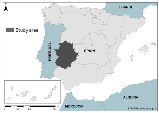
Figure 1.
Autonomous Community of Extremadura, Spain (study area).
In Extremadura, the number of population centers that exceed the threshold of 10,000 inhabitants, which was set by the National Institute of Statistics to separate the urban from the rural, is only 13 out of the 388 municipalities that make up the region. In addition, the size of these municipalities is only relevant in the population centers of Badajoz, Cáceres, and Mérida, which, in any case, do not exceed the level of small cities. The physical and demographic evolution of this urban triad depends specifically on its administrative functionality, such as provincial and autonomous capital, from which its area of influence derives. As can be observed from the latest population trends, Extremadura’s urban centers must compete under conditions of inequality with other national and international urban nodes. For this reason, the real estate dynamism of these cities depends on the flow of demographic attraction that they can retain.
Given the current characteristics of the region, in which the growth of cities is stagnant, rurbanization must take a leading role as the main object of study in territorial and urban issues.
This influence of cities and urban areas on rural areas, which was first noticed by Galpin in 1918 [2], and later defined by Bauer and Roux in 1976 [3], has particularly benefited from the neoliberal economic model. Under a system that aims at economic and urban deregulation [4], the Administration has clearly contributed to making Undevelopable Land (UL) more flexible, which is a predisposition that can be found at both the national level [5] and the international level [6].
Within this deregulatory transition, the rurban expansion has expanded thanks to the factual imposition of the law on what was built. However, in this implementation of an imported and improper urban model, there have been several imbalances. Firstly, the negative consequences of social conquests (higher purchasing power and leisure time) have materialized in the capitalization of income through secondary housing, which acts as an instrument of dissemination and dispersion of the city to the countryside [7]. Secondly, the colonization of certain places, such as Protected Natural Spaces, has its own real estate appeal. This spatial suggestion, which has been synthesized under the term naturbanization [8], has propitiated the transformation of the most vulnerable territories. Third and finally, human beings who occupy lands that are threatened by extreme natural conditions (floods and fires) are vulnerable to life-threatening situations. The result has been the consolidation of an unsustainable model, presumably uncontrollable, which society has progressively tolerated.
The consequences of this change in the urban model will have greater repercussions in the near future. This is because this new scenario inhibits the productive transformation of the territory by introducing a substitute seasonal residential land use for the traditional agricultural land uses due to the implementation of new unproductive activities. These changes have become a trend, and a new pattern of urban expansion, that has given a new role to the rural environment not only in Spain, but also in other Central European [9], North European [10], and Mediterranean [11] areas. Thus, this diffuse pattern of urbanization will strongly influence Extremadura, which remains at the bottom of the socioeconomic indexes of the country, and which has been particularly affected by a demographic depletion. The transition, in which in one way or another the Administration (inaction) and society (protagonists of urban transformation) have both participated, threatens not only the traditional model of settlement but also the sustainability of the system as a whole. The legal solutions that have been practiced in other spaces, such as housing amnesties [12], will not solve the unsustainability of the new system.
Initial Conditions. The Urban Network of Extremadura
Extremadura lacks an urban system due to its geographical, historical, social, economic, and political conditions. Its AUR (measured on a threshold of settlements with a population of more than 20,000 inhabitants) is 40%, thirty points lower than the Spanish average (70%), which places it second last among the Spanish autonomous regions. It is, and continues to be, a rural and ruralized region, with an extensive territory of 41,634.4 km2 and a minimal and embryonic urban network of urban centers, urban sub-centers, and “agrovillas” (population centers that are halfway between urban and rural). These, far from being consolidated, have been deconstructed in the last six decades. Nowadays, the few urban centers that remain form artificial oases in the middle of the demographic desert of the declining rural areas. The political opposition to the development of the Functional Districts Project [13] largely explains the regressive effects on sub-centers and agrovillas.
As can be seen from Table 1, the 1950 census marked the ceiling of demographic growth in Extremadura with 1,364,857 de facto inhabitants. As of 1 January 2017, the population stood at 1,079,022 de jure inhabitants, with a regression of −20.94% and annual losses that were derived from an already irrepressible bleeding due to depopulation, aging, and uncontrolled internal immigration from the countryside to the capital cities.

Table 1.
The urban network of Extremadura (1950–2017).
In 1950, the five urban centers (with over 20,000 inhabitants) Badajoz (79,291), Cáceres (45,429), Mérida (23,835), Don Benito (22,840), and Almendralejo (21,394), which represented 1.29% of the 386 existing municipalities, formed a concentration of 192,789 inhabitants (14.1% of the total population). In 2017, the seven urban centers Badajoz (149,946), Cáceres (95,814), Mérida (59,174), Plasencia (40,663), Don Benito (36,975), Almendralejo (34,543), and Villanueva de la Serena (25,992), which represent 1.8% of the current 388 municipalities, form a concentration of 443,107 inhabitants (41% of the total population).
This group (called “G-7”) has been, and will continue to be, the great beneficiary of the territorial and urban deregulation of Extremadura that occurred during the Franco dictatorship and that has continued throughout the democratic period. This is due to the absorption of people, goods, services, and central functions, and to the political decision to maintain, reinforce, and reproduce capital centralism during self-government, after the centralism of Madrid had been criticized for decades.
Intermediate centers (from 10,000 inhabitants to 20,000 inhabitants) occupy the second level in Extremadura’s urban hierarchy. These centers underwent notable contractions until they were totally dismantled. In 1950, the 18 sub-centers Azuaga (19,326), Villanueva de la Serena (18,391), Plasencia (18,203), Villafranca de los Barros (16,395), Jerez de los Caballeros (15,966), Valencia de Alcántara (15,586), Trujillo (14,587), Olivenza (13,894), Oliva de la Frontera (12,710), Montijo (12,100), Fregenal de la Sierra (11,993), Cabeza del Buey (11,931), Zafra (11,500), Arroyo de la Luz (10,424), Fuente de Cantos (10,354), Castuera (10,169), Barcarrota (10,099), and San Vicente de Alcántara (10,026) represented 4.7% of the total number of municipalities and formed a concentration of 242,654 inhabitants (17.8% of the total population). In contrast, in 2017, the six sub-centers Navalmoral de la Mata (17,247), Zafra (16,855), Montijo (15,674), Villafranca de los Barros (13,244), Coria (12,886), and Olivenza (12,032) represent only 1.5% of the total number of municipalities and 87,918 inhabitants (8.1% of the total population).
Agrovillas (10,000–5000 inhabitants) occupy the third level of the urban hierarchy of Extremadura; however, their role has been reduced by half. In 1950, there were 47 agrovillas, which represented 12.2% of the total number of municipalities and 308,552 inhabitants (22.6% of the regional population). In 2017, there were 24 agrovillas, which represented only 6.1% of the total number of municipalities (14.7% of the total population of Extremadura). Throughout this difficult transition, services have been dismantled and people have been displaced, including heads of districts, such as Jerez de los Caballeros, Trujillo, Azuaga, Jaraíz de la Vera, Castuera, and Valencia de Alcántara, Alburquerque.
In synthesis, the 70 centers that in 1950 represented 18.1% of the municipality of Extremadura and brought together 54.5% of the inhabitants, have now descended to 37 centers, 9.5% of the total, but concentrating 64.0% of the population. An evident example of the destructuring of the territory is that Extremadura today maintains its status as rural as in 1950, but with a serious problem of land depopulation, then nonexistent. These demographic losses are motivated by massive emigration, aging, dependence, lack of qualification and, above all, the immutable maintenance of the obsolete administrative structure inherited from the first Division of the Spanish Territory in 1822–1833: provinces and deputations, which block regional cohesion, and unviable mini-municipalities, converted into nursing homes.
Sixty-two years after the promulgation of the land law of 1956, which opened the way to urban growth planned through today obsolete figures, the phenomenon of rurbanization in Extremadura during the last forty years is today a serious problem. We are witnessing the substitution involution of the order planned by the spontaneous urban disorder on UL, caused by irregular, illegal, and clandestine constructions that are unsustainable. This disorder is not justified by the corresponding economic and demographic expansion, is in flagrant regression and is politically consented.
Municipal planning does not work since dynamic urban centers physically and functionally overflow the rigid limits of municipal boundaries. It is not even useful given its inability to understand and solve the narrow causal interrelations of influence between city and surrounding centers.
It is incomprehensible that, by arranging the municipalities of Extremadura regulated, urban and developable land to meet the scarce demands of urban growth, clandestine and illegal constructive developments take place on UL, presumably non-constructible land. In fact, this land type is in practice the most attacked by contradictory constructive uses, which even affect protected natural spaces.
The obsolete urban planning of municipal scale is incapable of ordering the rurban peripheries that already surpass the municipal limits [14]. We must resort to supramunicipal planning to solve this problem of management, since the periphery is a fragmented and confused space [15].
2. Materials and Methods
2.1. Study the Hidden Side
Facing the study of an urban phenomenon traditionally ignored, when not hidden, concerns a series of difficulties added to those inherent in any scientific research work. The problems increase when the agencies responsible for giving up the necessary information are potentially responsible (sometimes at a criminal level) for the propagation of the phenomenon studied and its conversion into a problem. Administrative neglect in Extremadura is expressed in the real magnitude of the phenomenon, through the anecdotal publications of an informative manual on the constructions in UL (Figure 2) and a report of these publications, whose results, although barely approximating reality, were also destined to oblivion. This last document, entitled “Study on the subdivisions, urbanizations and buildings outside the urban and urbanized perimeters. Extremadura and Évora,” is a basic and original dissertation published in the dawn of the validity of the current urban norm [16]. This work was partially funded by the Urban and Territorial Planning Department of the regional government, together with a Portuguese association of the same level, within the framework of cross-border relations of regional and local governments, Spanish and Portuguese.
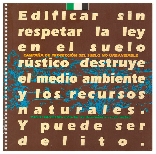
Figure 2.
Cover of the informative manual on the constructions in Undevelopable Land (UL).
The comparison between the results of the research carried out here and that carried out by the Public Administrations reinforces our position of maintaining uncertainty about the veracity of the data provided by official sources. The global computation performed (10,149 homes) does not represent even a third of those recorded by our research at that time.
The research objectives are the location, quantification, and dating of each residential building on UL, in addition to the control of possible constructive changes in terms of surface. Accordingly, there is an information gap on the part of the Local and Regional Administration; at the same time, there is a cadastral database full of errors and omissions. This database is currently being reviewed by the Department of Cadastre in the municipalities of Extremadura, within the framework of the cadastral regularization promoted by the Ministry of Finance. However, it is still an incomplete and useless process for the resolution of the problem by the Administrations, due to the lack of cooperation and exchange of data between them.
Once the availability of a reliable and accurate cartography was ruled out, the only viable alternative was the construction of an own database from scratch. To achieve the proposed goal, different methods and materials were used.
2.2. Sources and Processes to Reveal the Secrecy
The Territorial Information System of Extremadura (SITEX, Spanish acronym) is the regional and centralized repository of all current urban and territorial planning documents. Without the existence of this source, the collection of normative and planimetric information would have been chimerical since it would depend on an application for each municipality (388) and different response periods. Despite the advantage offered by this source, the status and characteristics of the documents make it difficult to transpose them into the Geographic Information Systems that will help us to practice spatial analysis. Because of the outdated state of planning, many documents are between 20 and 30 years old. The repository contains scans of originals and photocopies in PDF format, which means a necessary subsequent conversion to new formats to geo-reference and digitize them.
Once this process is completed, we have a vector layer with shapefile format and polygon topology on the urban classification and categorization of land throughout Extremadura. This means that we have precisely defined our study area: UL.
Along with this, analyses compared with other cartography, such as the sectorial one, allow us to notice discrepancies between the current classification of land and what should be by legal mandate. These examples are especially serious in the case of the existence of natural risks such as flood risks (Figure 3).
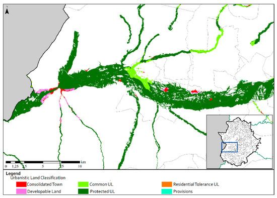
Figure 3.
Urban classification of flood zones.
The essential and main source within the building section is the National Geographic Information Center (CNIG, Spanish acronym). This free container of spatial information provides the necessary cartographic base to locate and quantify the phenomenon. The material used is the Aerial Orthophotography Series of the National Aerial Orthophotography Plan (PNOA, Spanish acronym), particularly the most current available ones.
The detection was carried out by sweeps (a maximum scale of 1:1500) of the entire regional territory, which made it possible to discover all existing buildings on the UL of Extremadura. It is a vector layer in shapefile format, with topology of polygons, which allows the very approximate knowledge of the surface area of all buildings (mostly, the residential construction in UL is led by single-storey homes).
This methodological phase is followed by one in which buildings are distinguished by uses. Because the theme studied is related to the residential function, four possible categories have been included: housing, possible housing, auxiliary buildings for housing, and others. To achieve this, a triple path has been followed. First, the orthophoto contains a series of informants for residential use, among which is the image of the building roof but also the adjacent space (landscaped areas, road network, enclosures, swimming pools, sports courts, etc.). Secondly, Google Earth images have been used, which in certain contexts have higher resolution than those belonging to the PNOA Series. The Google Street View and 3D modeling tools, available in its Google Maps portal and Google Earth software, also allow for the determination of the elevation and facade of the buildings. This is, in many cases, defining to discriminate the use of construction. For third and last place, in those cases where uncertainties persisted, it has been decided to determine their use through fieldwork. Despite these various paths, the category “possible housing” denotes that there are some cases in which it is impossible to reliably determine its residential use (hiding behind vegetation, buildings on very large plots, distanced from boundaries and access denied, lack of clear informers, etc.). As a prudential measure, it has been decided to register these cases but exclude them from the subsequent analysis.
Once the number of houses and their location (cross-analysis with the cartography created on classification and urban categorization) were determined, their appearance and the characteristics of their persistence in the territory were dated. For this, Web Map Servers available in the Spatial Data Infrastructure of Extremadura (IDEEX, Spanish acronym) were used to determine control points, depending on the series of aerial photography and orthophotography available. Finally, 6 control points were established (Figure 4):
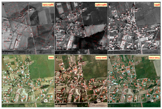
Figure 4.
Mosaic of used sweeps.
- Interministerial Sweep (1973–1986) [1° control point]: This helped to determine the starting situation, dated in Extremadura around the year 1981 (dawn of the democratic period).
- Ministerial Sweep (1980–1986): This is a register of the first urban growths in democracy and within a decentralized Spanish State.
- SIG “Oleícola” Sweep (1998): Initially, this flight was designed to quantify the number of olive trees and the extension of this type of crops. Its wide spatial coverage and date of taking the photographs served to discern what the urban growth was prior to the state land law of 1998.
- “SIGPAC” Sweep (2002): This was used to determine the urban growth before and after the regional planning law, although the main and general purpose of this flight is the identification of agricultural parcels that are beneficiaries of the Common Agricultural Policy (PAC, in Spanish acronym).
- PNOA Serie (2005–2006): This was used to determine urban growth until the end of the housing bubble in Spain.
- PNOA Serie (2012–2014) [6° control point]: This is an approach to the most current state of the residential expansion on the UL of Extremadura.
This material was used to measure rurban phenomenon evolution. The buildings were dated by means of an encoding process that contemplated the non-existence of the building at each control point (corresponding to a value of 0) and its existence (a value of 1). In addition, when the building lost more than 50% of the area recorded in the last control point, PNOA Serie 2012–2013, the event was identified with another value (a value of 5 appeared in the data table). The assignment of figures is a simple coding process and does not imply a posteriori calculation on these numerical values.
After dating the residential buildings, we proceeded to define their legal status. For this, we used the Urban Qualification Records (UQRs) and the only possible source, the regional government. The UQRs are the previous and indispensable authorization for building on the UL of Extremadura. Luckily, these are in a vector and geo-referenced format, although with duplications and errors that have been fixed. A simple analysis of spatial concomitance between these and the database created allowed us to approach the legal status of the dwellings. However, all this information offered a finite level of detail. This is because the regional database only covers the years of validity of the regional law (2002–present), the previous years remaining under local competition and whose data is not covered by centralized databases. On the other hand, it is also necessary to point out that, although the files are typified by uses, it is impossible to contrast the building reality with what is specifically allowed (heights, materials, dimensions of the construction, etc.) since the content thereof is not accessible. Even when an UQR authorizes a home, this does not mean that the rest of the subsequent and necessary procedures have been fulfilled (such as the request and the fulfillment of the urban planning license, still in the hands of the municipal corporations).
Another source of fundamental information is the press, the pulse of the social relevance of the phenomenon, consolidating itself as an indicator. Analysis of the regional press in a region like Extremadura, far from the national media focuses, elucidates their daily life. For the particular monitoring of the rurbanization (only in the arena when it has an irregular status), it is necessary to consult the two most important newspapers, “Diario Hoy Extremadura” and “El Periódico Extremadura”, both belonging to the written press, but with digital editions. The search process during the research period (2012–2017) has been daily, resulting in an uninterrupted media impact during all months recorded (72). This translates into about 700 news stories related specifically to illegal urban development developed on UL. This data reveals that this phenomenon within Extremadura is still very active.
The study through the press also allows us to position the media impact on a map, quantifying and locating not only the specific issues addressed (housing complaints, demolitions, political derivations, etc.) but also the media impact according to the affected municipalities. In addition to its function as a source, the press serves as a vehicle for the transfer of research results. In this sense, a symbiotic relationship that benefits the research is not only known by the scientific community but by the parts of society that are affected by the problem (Figure 5).
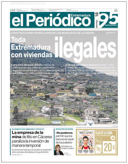
Figure 5.
Public impact of the study on a newspaper cover.
Treating a problem that concerns laws and urban discipline inevitably leads to recourse to competent agencies in these matters. In this way, the Nature Protection service of the Spanish military police (called SEPRONA) can constitute another source of data. This information will help us not just to discover the phenomenon but also to determine the methodology used in the fight against crimes in territorial and urban planning. In response to the data received, the action of this agency, in spite of relatively effective agencies (Agents of the Natural Environment, National Police, municipal surveillance teams and rural guards, etc.), is very far from the true magnitude of the phenomenon. The spatial analysis of the denunciations reveals, moreover, that their productivity depends more on the close existence of dependencies of the Spanish military police than on the very magnitude of the rurban phenomenon. Last and most worrying is the fact that, within the methodology used for the detection of housing on UL, chance comes into play as a variable of great weight. This is because the localization procedures are carried out in situ, through physical patrols, and without an editable and centralized registry. This procedure makes repetitions, failures, and omissions feasible, reducing their effectiveness and triggering the costs of surveillance.
For a full knowledge of the problem, the methodological process requires in addition to the information provided by the Delegate Office of the Environment and Urbanism. Thus, interviews and personal encounters with those responsible for such an organization are essential to explore the criminal aspect of this urban and territorial phenomenon.
This same procedure has been used to determine municipal work and perceptions of the phenomenon. In the present case, almost a hundred online surveys were carried out on municipal officials, which means that almost a quarter of the localities responded. This value must be put in context, as the subject is considered by municipal officials to be taboo in light of the legal and criminal consequences, which makes the answers difficult.
3. Results
The application of the methodological process led to the detection of almost 40,000 houses on the UL of Extremadura, with a distribution very unbalanced in the quantitative level but very distributed in spatial terms. In fact, only two municipalities of the 388 that compound Extremadura are free of housing on the UL, according to the last control point used (Figure 6).
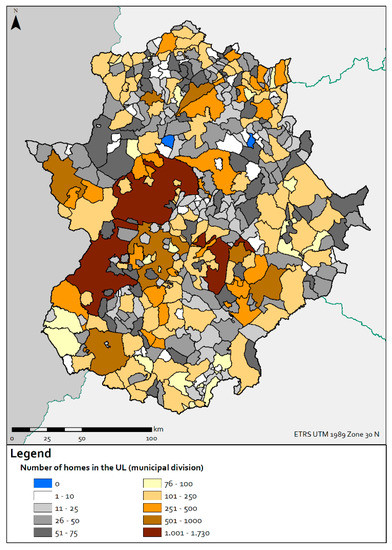
Figure 6.
Number of homes on UL (municipal division).
The unequal distribution is due to the influence that certain factors have on the territory. The first and main factor is the urban irradiation that the urban centers of Extremadura generate. In a much lower magnitude, but with equally worrying results, the presence of population centers determines the near existence of scattered housing. The peripheral spaces of these nodes are colonized by residential construction, regardless of whether they belong to the rural environment.
In the same way, the communication routes are fundamental, since their close presence increases the enclaves’ level of accessibility. This factor, combined with the previous one, determines a greater or lesser colonization of the urban peripheries.
The environmental and landscape aspect is very relevant when measuring the real estate attractiveness of the land. Setting only the analysis in the official delimitation of Protected Natural Spaces, the present investigation revealed the existence of more than 5300 houses within its limits. These houses represent a serious threat not only for the territorial organization but also for the environmental values of the region.
In a still more worrying stage are those homes at risk of suffering a natural catastrophe. If we use the risk cartography available to Public Administrations and combine it with the database created, we can assure that there are more than 1500 homes in the area at risk of being flooded (350 residences built in the areas of shorter recurrence time, 10 years) and more than 15,000 homes in fire risk zones (around 13,000 residential buildings in the High Risk Areas).
The relevance of the phenomenon has promoted actions aimed at regularizing housing, such as the integration of entire groups (made up of hundreds of residences) in isolated sectors of Developable Land.
Although the Extremadura law indicates that this simple demarcation operation is not enough (since it requires starting specific regularization processes), this serves to silence criticisms and hide, at least partially (Figure 7), the presence of housing for our methodology.
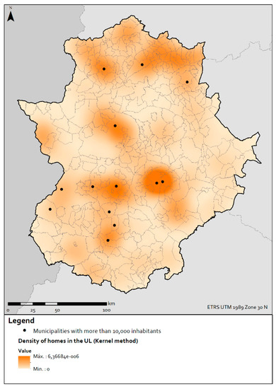
Figure 7.
Density of homes on UL.
This is the case of Badajoz, which is the municipality that has the greatest and most prominent rurban development in the region, although it ranks third in terms of the number of homes on UL.
The dating of the houses (Figure 8) helps us to understand the proliferation of residences on UL as a progressive phenomenon, dependent on economic cycles. Although the construction of houses in the first control point represented almost a third of the existing ones, their formal and constructive characteristics (“cortijos” and large houses) indicate that they were residences linked to an agricultural use or, as recreational housing, belonged to middle-upper and upper classes.
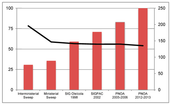
Figure 8.
Evolution of rurban development in Extremadura. The percentage of the total number of homes built on UL (bars) and average area (m2) of homes (lines).
Over time and socio-economic progress, the phenomenon became more transversal, which reduced the average size of the houses and densified certain spaces, such as the peripheries to settlements. In these environments, the rustic smallholding of atomized property was replaced by secondary homes.
The influence of certain flexibilizing legislation, such as the 1998 land law, led not only to the increase in real estate activity in Urban and Developable Land, but also to UL. In just four years, the number of homes on UL grew by around 4500. Consequently, the prodigious decade of Spanish urbanism reported to Extremadura an increase of 10,000 homes on UL.
Finally, looking exclusively at the legal aspect of the matter, data on UQRs place the maximum threshold of legally constructed homes since 2002 at 760. This figure is substantially below the total number of residences built in this class of land, which demonstrates the eminent irregular nature of the rurbanization, despite the continued flexibility of the regulations and urban planning.
4. Discussion
Given the important magnitude and actuality of the rurban phenomenon in Extremadura, the certainty of being able to practice urban geography outside the cities, and even its opportunity and usefulness, is reaffirmed. Having overcome the monopoly and prominence of architects and road engineers in urban planning [17], this work aims to reaffirm our role as geographers in the study of a process that concerns the territory and people. The importance of the study of urban expansion in rural areas, substantially the deepest and most peripheral, is dispelled by the inability or impossibility of finding concrete urban landmarks (already re-signified as icons), which provide research with attractiveness and remarkableness.
The particular legal aspect of the rurbanization in Extremadura (an antithetical example of the urban discipline) and the scarce administrative and academic attention confirm the need for an independent geographical study, not only in its approach and elaboration but also with respect to the sources that build the database.
The only attention comes from media (consequence of the possible criminal repercussions for the political class and very dependent on the potential repercussion in supramunicipal spheres), although this only has the function of alerting others of the phenomenon, without proposing solutions. In fact, the recurrent appearance of related news does not even encourage resolute action, since the published cases affect the municipal sphere, which prevents understanding of the situation in its true dimension, the regional one.
This last point is what triggers the study carried out from urban geography, since the knowledge and analysis of the event has no significance if it is not accompanied by urban and territorial reorganization.
In the face of a consensual clandestine development, it is only possible to carry out a scientific study that is separate from the collection of official information and focuses on the collection and production of own data, taking official data into account or potentially constituting a new point of reference.
5. Conclusions
The irregular rurban expansion is the main urban and territorial problem of the region. The almost 40,000 homes built on the UL of Extremadura, most of which are illegally implemented, are a tangible and living reality that will be maintained over time (at least in its current magnitude), by the prescription of a large part of the infractions and crimes.
In addition, this phenomenon affects the region as a whole vector (only two municipalities of the 388 that compound Extremadura do not have housing on UL) that should encourage decision making in this regard.
Extremadura needs a new territorial scheme that conditions urban regulation. This is only possible through the promulgation of a new regional land law and the implementation of a better control system of urban discipline.
This vigilance is fundamental to stop an illegal and clandestine urban development that expands by contagion and reaches highly relevant values in peripheral zones of the “big” cities in Extremadura. Urban irradiation of the cities generates these results in their UL and in the neighboring rural municipalities, which act as dormitory settlements.
Obviating this fact again implies allowing the validity of the norm and planning to be questioned. These are the mechanisms that will later serve to justify theoretically and politically the deregulation and flexibilization of UL, which for decades has been practiced in Spain and other countries.
The legal mandate to maintain urban discipline fails, in the first place, due to administrative inaction (caused by a combination of factors, including the Administration’s lack of interest, the political yield of permissiveness, and the negative electoral consequences of the persecution of illegality and citizen pressure) and to the methodological deficiencies of the agencies responsible for ensuring this respect (SEPRONA, Local Police, Natural Environment Agents, etc.).
Due to this, Extremadura must face the creation and application of a Regional Plan for Management and Control of Rurban Development. This plan has to have a centralized technical management (not political), which contains both legalization and demolition programs. Only in this way will it be possible to erect a point of inflection that will redirect and reorganize the most important type of urban development in the regional present.
Author Contributions
V.J. and A.-J.C. developed the conceptualization and the topic; V.J. set up the methods; V.J. and A.-J.C. wrote the paper; A.-J.C. supervised the original draft and analyzed the data.
Funding
This research was funded by FPU pre-doctoral research grant of Ministry of Science, Innovation and Universities (Spanish Government), grant number FPU13/00990.
Acknowledgments
We want to thank the work of the Urban Geography Group of the Association of Spanish Geographers (AGE) for the dissemination and internationalization of this discipline.
Conflicts of Interest
The authors declare no conflict of interest. The funders had no role in the design of the study; in the collection, analyses, or interpretation of data; in the writing of the manuscript; or in the decision to publish the results.
References
- Mattson, K. Una Introducción a la Geografía Radical. GEOcrítica 1978, 13. Available online: http://www.ub.edu/geocrit/geo13.htm (accessed on 21 February 2018).
- Galpin, C.J. Rural Life, 1st ed.; The Century Co.: New York, NY, USA, 1918. [Google Scholar]
- Bauer, G.; Roux, J.-M. La Rurbanisation ou la Ville Éparpillée, 1st ed.; Editions du Seuil: Paris, France, 1976; pp. 1–192. [Google Scholar]
- Rullán, O. Economía y sostenibilidad de las ciudades: Entre la desregulación y la planificación. In La Ciudad: Nuevos Procesos, Nuevas Respuestas, 1st ed.; López, L., Relea, C.E., Somoza, J., Eds.; Biblioteca Virtual Miguel de Cervantes: Alicante, Spain, 2003; Volume 1, pp. 151–168. [Google Scholar]
- Jiménez, V.; Delgado, C.; Campesino, A.J. Desregulación urbanística del suelo rústico en España. Cantabria y Extremadura como casos de estudio. Revista Geografía Norte Grande 2017, 67, 73–92. [Google Scholar] [CrossRef]
- Jiménez, V.; Hidalgo, R.; Campesino, A.J.; Alvarado, V. Normalización del modelo neoliberal de expansión residencial más allá del límite urbano en Chile y España. EURE 2018, 132, 27–46. [Google Scholar] [CrossRef]
- Delgado, C. Vivienda secundaria y turismo residencial como agentes de urbanización y segregación territorial en Cantabria. Scr. Nova 2008, 269, 256–280. [Google Scholar]
- Prados, M.J. Naturbanización y patrones urbanos en los parques nacionales de Andalucía. Boletín Asociación Geógrafos Españoles 2012, 60, 19–44. [Google Scholar]
- Biegańska, J.; Środa-Murawska, S.; Kruzmetra, Z.; Swiaczny, F. Peri-urban development as a significant rural development trend. Quaest. Geogr. 2018, 37, 125–140. [Google Scholar] [CrossRef]
- Adamiak, C.; Pitkanen, K.; Lehtonen, O. Seasonal residence and counterurbanization: The role of second homes in population redistribution in Finland. GeoJournal 2017, 82, 1035–1050. [Google Scholar] [CrossRef]
- Barbati, A.; Corona, P.; Salvati, L.; Gasparella, L. Natural forest expansion into suburban countryside: Gained ground for a green infrastructure? Urban For. Urban Green. 2013, 12, 36–43. [Google Scholar] [CrossRef]
- De Biase, C.; Losco, S. Up-grading Illegal Building Settlements: An Urban-Planning Methodology. Procedia Environ. Sci. 2017, 37, 454–465. [Google Scholar] [CrossRef]
- Junta de Extremadura. Estudio Territorial de Extremadura I; Junta de Extremadura: Mérida, Spain, 1992. [Google Scholar]
- Campesino, A.J. Centros y periferias urbanas: Ordenación y desgobierno. In Reflexiones Sobre las Ciudades y el Sistema Urbano en Tiempos de Crisis, 1st ed.; Lois, R.C., Miramontes, Á., Eds.; Universidad de Santiago de Compostela, Grupo de Geografía Urbana (AGE): Santiago de Compostela, Spain, 2014; Volume 1, pp. 91–117. [Google Scholar]
- Feria, J.M. Nuevas periferias urbanas y planificación pública. In La Ciudad. Tamaño y Crecimiento, 1st ed.; Domínguez, R., Ed.; Universidad de Málaga, Grupo de Geografía Urbana (AGE): Málaga, Spain, 1999; Volume 1, pp. 309–316. [Google Scholar]
- Junta de Extremadura. Estudio Sobre las Parcelaciones, Urbanizaciones y Edificaciones Exteriores a los Perímetros Urbanos y Urbanizables; Junta de Extremadura: Mérida, Spain, 2004. [Google Scholar]
- Campesino, A.J. El geógrafo en el planeamiento urbano: Avatares de una conquista profesional. Boletín Asociación Geógrafos Españoles 1985, 2, 24–35. [Google Scholar]
© 2018 by the authors. Licensee MDPI, Basel, Switzerland. This article is an open access article distributed under the terms and conditions of the Creative Commons Attribution (CC BY) license (http://creativecommons.org/licenses/by/4.0/).