Abstract
Bed shear stress in coarse–bed rivers with vegetation patches is one of the challenging parameters in hydraulic engineering, mechanical engineering, fluvial morphology, and environmental studies. Based on this necessity, in this study, the values of bed shear stress in four reaches of rivers in Iran were estimated and compared using the methods of boundary layer characteristics, logarithmic law, and Darcy–Weisbach. Data collection in this study started in February 2021 and ended in April 2021. Estimation of flow resistance is a key factor in many numerical and physical models. In order to obtain a reasonable evaluation of this factor, it is necessary to measure and calculate the key variables of resistance to flow. Accordingly, the experimental design in this study includes surveying operations, velocity measurement, and sampling of bed sediments. The results show that due to bed forms, vegetation patches, and variations of flow depth and grain size in the river, the universal velocity distribution law (the log law) may not be suitable to estimate the shear velocity, which is a key parameter of flow resistance. This calls for more justifiable methods which are not affected by near–the–bed conditions. Accordingly, a three–parameter flow resistance model is presented, which shows an average error of 17%, indicating the accuracy of the model. The investigation of 71 measured velocity profiles shows the occurrence of the Dip phenomenon in the velocity profiles near the vegetation patches. However, by moving away from the vegetation patches, the effect of this phenomenon is decreased, and the profiles illustrate an S–shaped distribution. The results show that the relative differences between the logarithmic law and Darcy–Weisbach methods compared to the boundary layer characteristics method (BLCM) are equal to 87% and 39%, respectively, indicating a more reasonable agreement between the Darcy–Weisbach method and the boundary layer characteristics method. This is due to the application of key parameters of the boundary layer theory to calculate shear velocity by BLCM. However, to simplify data collection in the field, the application of the Darcy–Weisbach method is suggested.
1. Introduction
Vegetation patches in riverbeds affect the main flow parameters, such as shear stress and velocity, change in the flow structure, and increase in the overall resistance of the flow. The most apparent effect of vegetation patches in water transfer canals is to reduce the shear stress of the bed, increase the flow resistance, and reduce the water transfer capacity. Vegetation patches are widely observed in rivers, and their presence in the flow path can change the velocity profile and shear stress. These patches are different from other obstacles such as bridge piers due to their permeability [1]. In the past, it was supposed that vegetation only increases the flow resistance; for this reason, to increase the flow transmission capacity, the vegetation at front of the stream was removed; while today, we know that it has several benefits. For instance, the patches can create a suitable environment for aquatic life, growth, and spawning [2,3] and reduce erosion by decreasing shear stress [4,5,6,7].
Bed shear stress is one of the main parameters in the river and hydraulic engineering, the estimation of which is always accompanied by an error in river engineering. Up to the present date, a complete model for coarse–bed rivers based on the theoretical foundations of boundary layer and flow velocity distribution is unavailable. Most models are entirely experimental, and the effect of flow structure is not considered in them. Bed shear stress is a significant factor in estimating hydraulic parameters, design of hydraulic structures, and river engineering studies. In rivers, the bed shear stress is essential in determining the local erosion of the bed, the roughness coefficient, the sediment parameters of the bed load, and the suspended load. Accurate estimation of bed shear stress is difficult, especially in mountain rivers. In laboratory studies, Prandtl–Pitot tubes or shear plates are used to measure the bed shear stress, while in field studies, direct measurements are rarely done, and various indirect methods are used. There has been numerous research on the interaction of vegetation and flow in the presence of artificial vegetation and the laboratory flume (e.g., [8,9,10,11]); however, few studies have been conducted on natural vegetation in coarse–bed rivers (e.g., [12]).
Thoman and Niezgoda (2008) investigated the effect of vegetation on bed shear stress, which is a key factor in determining the pattern of sedimentation and erosion. They showed that the presence of vegetation reduces the velocity in the regions near the bed and thus reduces shear stress and erosion [13].
Depending on whether the vegetation is flexible or rigid, as well as submerged or emergent, models have been developed to estimate flow resistance in the presence of vegetation [14,15]. However, so far, a comprehensive model for predicting flow resistance has not been found [16]. Since most of these models have been developed under laboratory and controlled conditions, their generalization to river conditions cannot be easily done. Therefore, it is necessary to develop a comprehensive model for river conditions.
Due to the drought phenomenon, the river flow is not established in all seasons, which results in vegetation growth in the river beds. Nosrati et al. (2022) focused their study on the effect of irregular vegetation on flow resistance in a sandy river. Their results showed that the effect of vegetation cover on the total flow resistance is greater than the effect of the bed form of the river. Therefore, in order to correctly estimate the flow resistance in mountain rivers and its application in hydraulic models, engineers and designers must pay special attention to the contribution of vegetation in the estimation of flow resistance [17]. In another study, Afzalimehr et al. (2019) studied the flow on a sandy bed with walls covered with vegetation. They showed that the presence of vegetation causes the flow to change from uniform to non–uniform despite the constant depth of flow and constant slope. They showed that the reason for this change in the flow structure is the non–uniform distribution of the Reynolds stress and the occurrence of the maximum velocity below the water surface due to the presence of vegetation on the channel wall [18].
The most common method for estimating the average bed shear stress in a reach is defined as follows:
where is bed shear stress, is the specific gravity of water, g is the gravitational acceleration, is the hydraulic radius, andis the energy slope. This method is not suitable for local estimation of bed shear stress. Assuming that the hydraulic radius is equal to the depth of the water flow, and by substituting the slope of the energyfrom the Manning equation, Equation (1) becomes:
where n is the Manning coefficient, is the flow velocity, and h is the flow depth. Equation (2) represents the most common approach adopted in most hydrodynamic software packages. The Manning equation is not a reliable method in rivers; because the Manning roughness coefficient considers the water depth and flow velocity as constant, which is different from the actual conditions due to the non–uniformity of the flow and the presence of obstacles in rivers [19]. Afzalimehr et al. (1999) showed that applying the Manning coefficient with the assumption of uniform flow in a river is accompanied by an error of approximately 500% [20].
Bellos et al. (2018) proposed a new three–parameter flow resistance model for open channels in which the bed shear stress is proportional to the flow velocity and inversely to the water depth as the following [21]:
where A, B, and C are the three parameters of the flow resistance model. For A = 2, B = , and C = 1/3, this model is the same as the classic flow resistance model (Equation (2)), which is based on the Manning equation. Therefore, it can be concluded that the classic flow resistance model is a particular case of the proposed resistance model that includes three parameters instead of one parameter. This model is valid for all flow and roughness properties, and it is proposed to replace the Manning equation in flood simulation models. By combining Equations (1) and (3), the flow velocity is calculated as the following:
Equation (4) estimates the flow velocity by considering the effect of vegetation patch and roughness size through coefficients A, B, and C, to better evaluate the flow resistance. The three parameters of the mentioned flow resistance model (A, B, C) are calibrated based on random data from a uniform probability distribution of water depth, flow velocity, and roughness height; however, it has not been calibrated based on laboratory and field data. In addition, the effect of vegetation has not been considered for calibration of these parameters, which must be considered. This research aims to calibrate this model based on different bed shear stress methods by considering vegetation patches. There are various methods for calculating bed shear stress. In this study, three widely used methods have been implemented to calibrate the three–parameter flow resistance model. The descriptions of these three methods are given below.
Shear velocity and local bed shear stress can be calculated using the relationship based on the boundary layer characteristics as follows [22]:
where and θ are the thickness of the boundary layer displacement and the thickness of the momentum, respectively; is the maximum velocity in the velocity profile, and is a constant value obtained in coarse–bed rivers which is equal to 4.4 [23]. The researchers have used boundary layer characteristics for sandy and gravely beds in the last 20 years [18,24,25]. This method is not applicable in boulder–bed rivers.
The velocity profile in the inner layer where the viscosity is dominant follows a logarithmic law and is as follows:
where z is the distance from the bed, ks is the equivalent roughness height, k is the Von Kármán constant, and Br is the integration parameter. The logarithmic law method for determining the bed shear stress is one of the most valid methods. The following points are significant about this method:
- Emadzadeh et al. (2010) and Fazlollahi et al. (2007) showed that the Von Kármán constant is less than 0.4 in the conditions of sediment transfer and more than 0.4 in the presence of the bed form; and in the absence of these cases, it is equal to 0.4. In this study, the value of 0.4 has been used [26,27]. Naderi et al. (2021) found a value of 0.4 for reaches with vegetation cover when there is no sediment transport, and the effect of bedforms is insignificant [28].
- Different researchers have found different values for ks; For example, Song and Chiew (2001) presented the value of and Alonso et al. (2009) presented the value of . The amount suggested by Alonso et al. (2009) has been used in this study [29,30]. In this study, to show the effect of larger particles on surface roughness in coarse rivers, ks = 2.4 d90 was considered.
- In coarse–bed rivers, there may be a flow between the coarse–grained particles and below the measured points; therefore, the flow has a velocity at zero depth and cannot be considered zero. Therefore, to solve this problem, a concept called hypothetical line is used. A hypothetical line is a line on which the velocity is zero. This line is defined as follows:
Song and Chiew (2001) suggested a value of 0.25 for , which is also considered in this study. Different researchers have proposed different values for . The value of d84 is usually used to show the greater effect of larger particles on surface roughness in coarse–bed rivers [29]. According to the hypothetical line definition, the final relationship of the logarithmic law method that is valid in the inner layer of the flow is as follows:
To determine the shear velocity and bed shear stress using a logarithmic law, the validity range of this law must first be calculated. The coefficient of determination index (R2) is used to determine the validity range of the logarithmic law. Depth with the highest coefficient of determination is considered the upper limit of the logarithmic law. After regression between and and calculation of the slope of the regression line (m) and y–intercept (b), the following equations are used to calculate the shear velocity, bed shear stress, and integration constant:
Another method for estimating shear stress is the Darcy–Weisbach method, which is defined as follows:
where f is the Darcy–Weisbach friction factor. In this study, the method proposed by Bellos et al. [21] was used to calculate the Darcy–Weisbach friction factor (Equation (15)).
The main difference between this research and other research presented in the literature is the use of field data to validate different methods of bed shear stress in the presence of vegetation patches. The originality of this research is the use of field measurements for calibration and validation of the flow resistance model.
To achieve the research objectives, the research assumptions include the following:
- The selected reaches have a direct path without the presence of obstacles such as boulders.
- The transfer of sediment from the bed is insignificant.
- The wind velocity in the area does not affect the velocity profiles.
- There is no flexibility in vegetation patches and deformation during data collection.
In many seasonal rivers in dry regions, there is no flow in rivers. This leads to growing vegetation patches through rivers. However, no research has reported the influence of these patches on flow resistance estimation. This study applies different methods of shear stress estimation and reveals that the most suitable method to predict flow resistance is the three–parameter flow resistance model.
This paper consists of four main sections. In the first section, the theoretical foundations and various relationships for calculating the shear stress of the bed are discussed. The materials and methods section explains how to measure the data and calculate the parameters used in this study. In the results section, different methods of bed shear stress in the presence of vegetation patches are compared and analyzed. Finally, the main findings of the research are presented.
2. Materials and Methods
2.1. Reaches Location
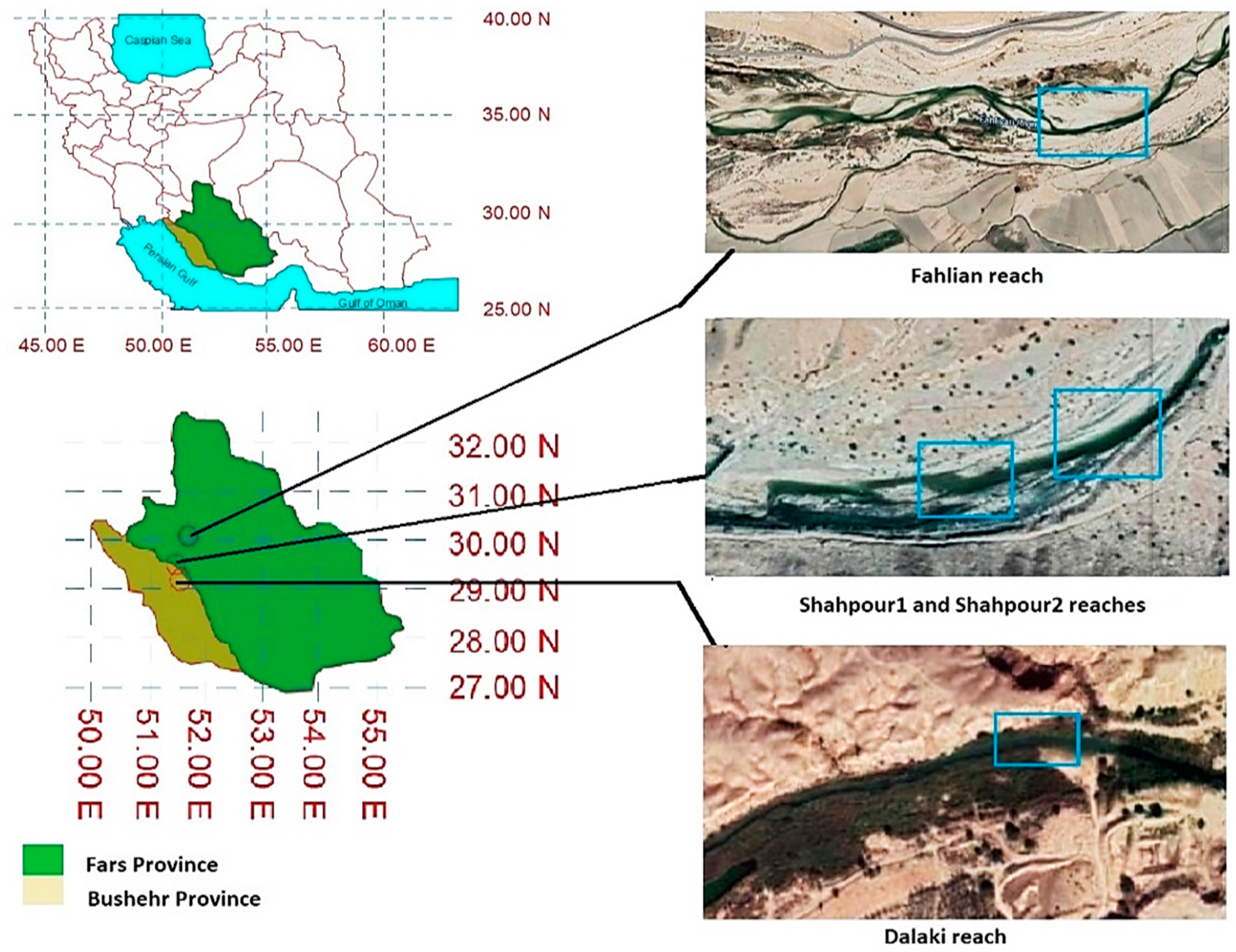
Several factors are considered in choosing the appropriate reach in the river, the most important of which is the safety of the researcher and the objectives of the research. Accordingly, the flow velocity and the average depth of the selected reach should be such that the data collection is done with minimal errors and fluctuations and the researcher’s safety is not risked. According to these points, finally, two reaches of Shapur River (Fars province), one reach of Fahlyan River (Fars province), and one reach of Dalaki River (Bushehr province) were selected. All three selected rivers are located in Iran. Figure 1 shows the geographical location of the studied reaches.
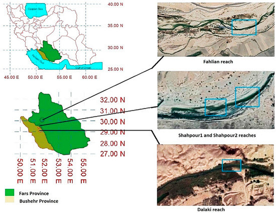
Figure 1.
The geographical location of the studied reaches. Blue frames show study areas.
The selected reaches had a straight path without physical obstacles such as boulders. Data collection time started in February 2021 and ended in April 2021. A summary of the general information of the selected reaches is presented in Table 1. In the table, Lr is the reach length, D is the average hydraulic depth, W is the average width, S0 is the longitudinal slope, and Q is the discharge. According to the table, Shapur1 and Shapur2 have the highest cross–section width and depth of the flow, respectively, and the largest discharge belongs to Shapur1. Brierley and Fryirs (2005) stated that the longitudinal slope for sandy and gravely rivers is in the range of 0.05% to 0.5%, which in this study is in the same range for the longitudinal slope as well [31].

Table 1.
Summary of general information of selected reaches.
2.2. Vegetation Patches in Selected Reaches
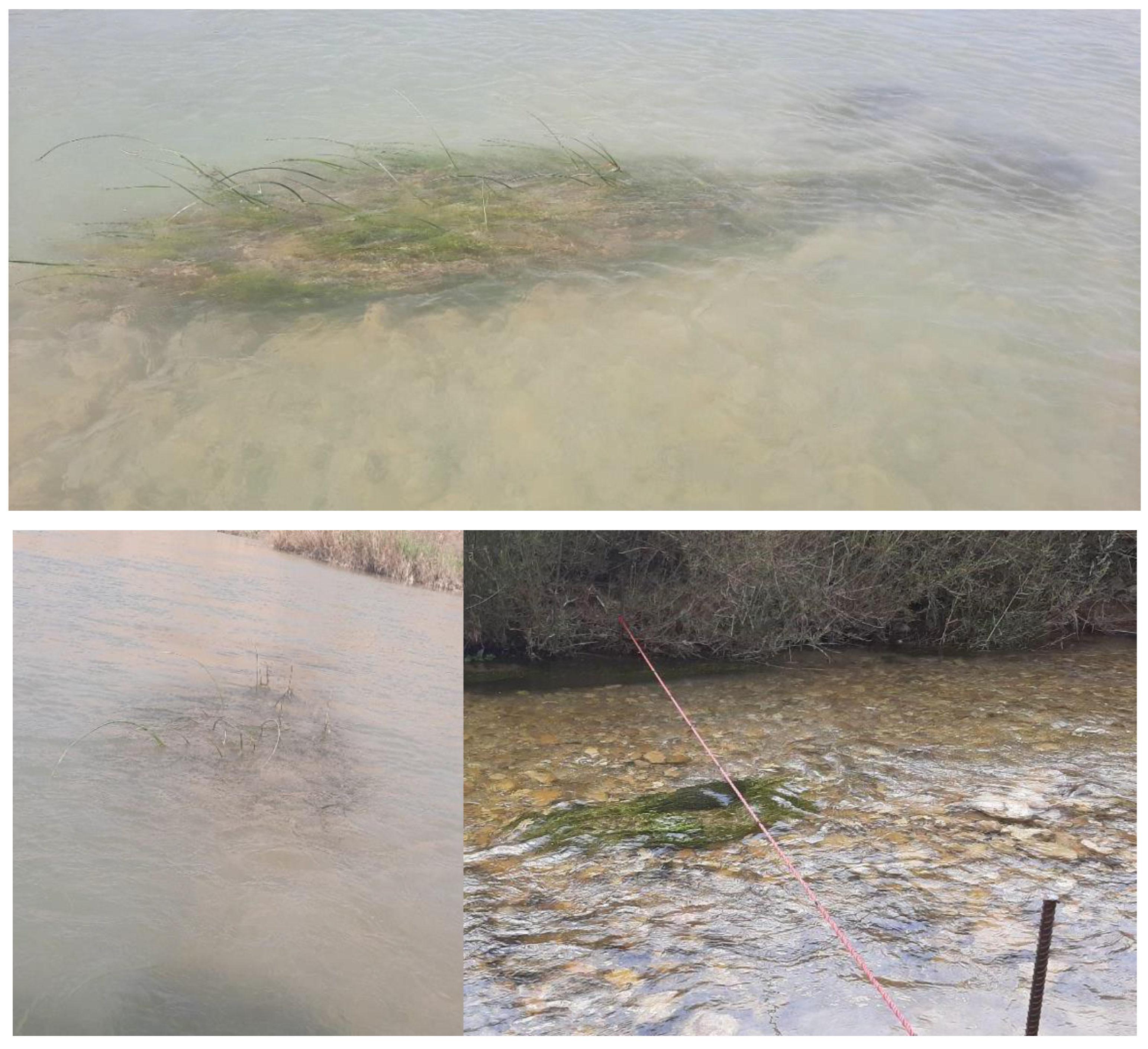
The four studied reaches were selected with different amounts of vegetation patches. Shapur1 and Dalaki reaches on their left bank (looking downstream) have emerged vegetation patches. There are scattered submerged vegetation patches in the bed of these two reaches with different dimensions. Selected reaches in the Fahlyan and Shapu2 rivers have submerged vegetation patches in the bed and emerged vegetation patches on their right bank. The average height of submerged vegetation patches in Shapur1, Shapur2, Fahlyan, and Dalaki reaches were 18, 15, 12, and 9 cm, respectively. Figure 2 shows some vegetation patches in the selected reaches. Table 2 presents the characteristics of the vegetation patches of the reaches, and average relative submergence (ratio of vegetation patch height to flow height), cross–sectional blockage factor (area of the cross–section occupied by the vegetation patch), surface blockage factor (area of the study reach occupied by the vegetation patch), and volumetric blockage factor (ratio of volume covered by vegetation patch to canal volume) are , BX, BA, and BV, respectively.
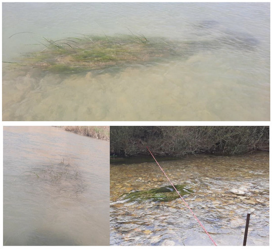
Figure 2.
Some vegetation patches in selected reaches.

Table 2.
Vegetation patches’ characteristics of the reaches.
2.3. Measured Data
Measurement data in this study include velocity measurement, surveying operations, and sampling of bed sediments, respectively. The order of data measurement in river engineering is important; for example, if sampling of bed sediments is done before surveying operations, changes in riverbed level may cause the surveying operation data to be inaccurate.
2.3.1. Velocity Measurement
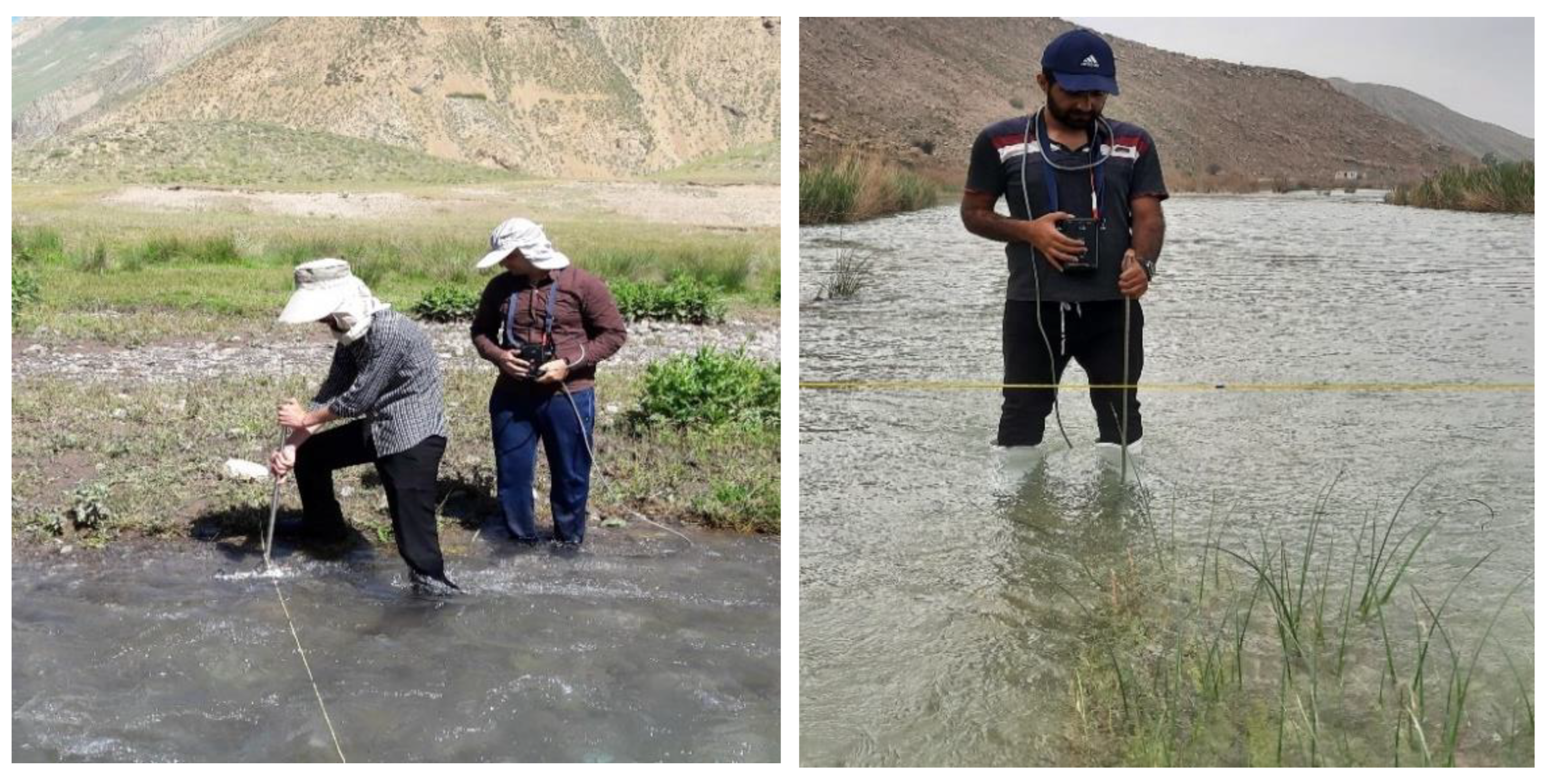
Velocity measurement at different points and depths of the stream is one of the essential tasks in river engineering studies. Various velocimeters are used to measure flow velocity. The most common velocimeter for measuring point velocity in field studies is the butterfly current meter (BCM), which was also used in this study. To reduce the error in velocity measurement, in this study, the measurement time was considered 20 seconds, and the number of repetitions in velocity measurement was considered 3 to 5 times. In velocity profiles, the number of measured points near the bed (inner layer) was considered more so that the distance between the measuring points was 0.5 cm. In each reach, 4 to 5 cross–sections, and in each cross–section, 3 to 4 velocity profiles, one of which was located in the middle of the cross–section, were measured. Moreover, 16 to 22 points (an average of 19 points) were considered in each profile. In addition, to calculate the discharge in each cross–section more accurately, the flow velocity was measured at 0.2 and 0.8 depths from the bed at a distance of 1 m in each cross–section. For example, for the first cross–section of Shapur1, which had a width of 28.4 m, four velocity profiles with an average of 19 points per profile and 28 two–point velocity profiles were measured. Figure 3 shows the measurement of velocity at selected reaches. Table 3 shows the number of velocity measurement points at the four selected reaches. In the Table, is the number of velocity measurement points in the 19–point profile, is the number of velocity measurement points in the two–point profile, and Fr is the frequency of velocity measurements by considering 3 to 5 repetitions at each point. According to the table, the total velocity of 2174 points has been measured in these four reaches, which by considering 3 to 5 repetitions for each point, the total number of velocity measurements is 8184 times.
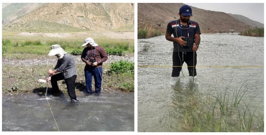
Figure 3.
Velocity measurement at selected reaches.

Table 3.
The number of velocity measuring points in the four studied reaches.
2.3.2. Surveying Operations
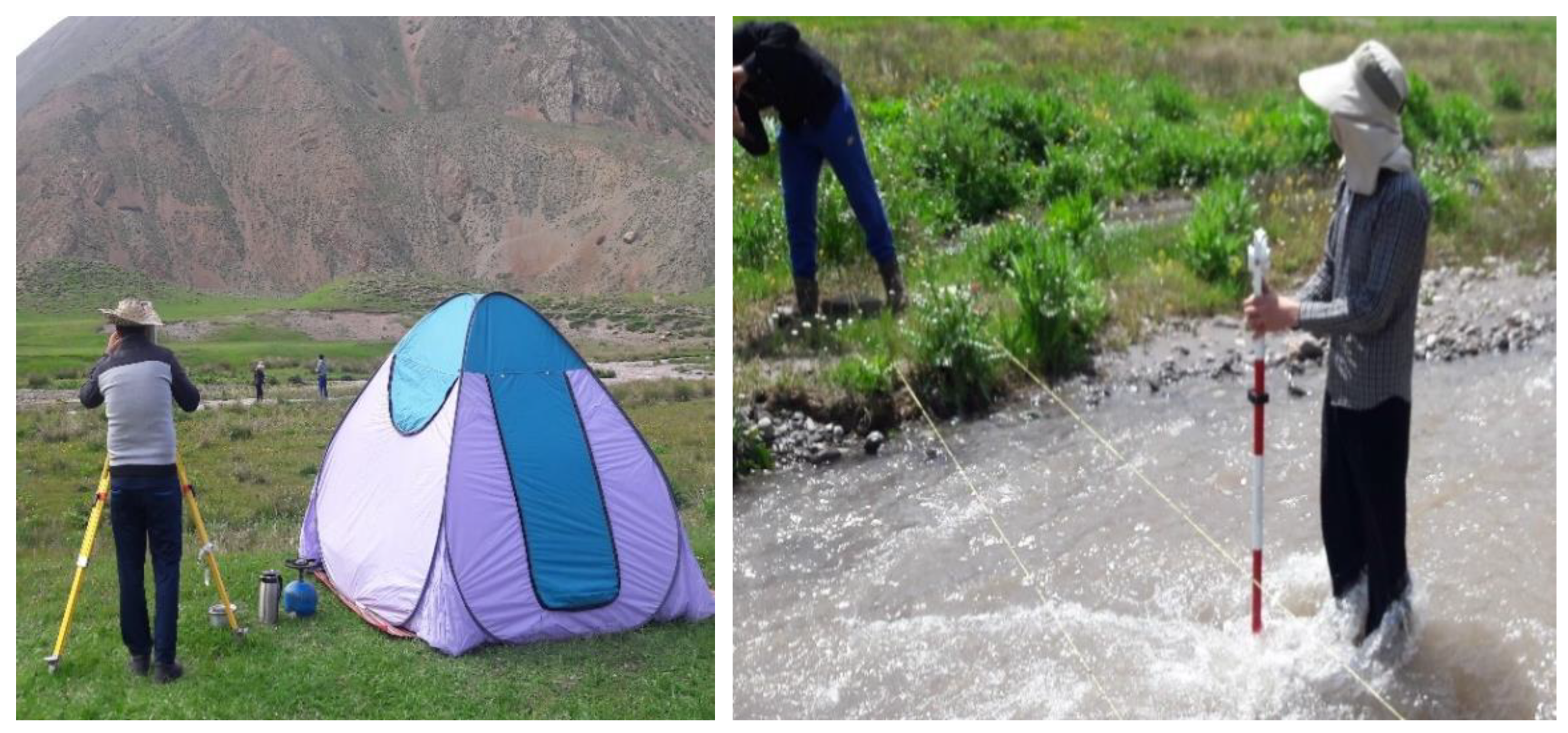
In order to calculate the area, wet perimeter of cross–sections, longitudinal slope, and the dimensions of vegetation patches in the studied reaches, in this study, Leica TS02 Total Station Camera was used. For surveying, the selected reaches were networked by ropes with dimensions of 1 m in the longitudinal direction and 0.5 m in the cross–section direction of the river, and then the surveying was performed. Figure 4 shows the surveying in the studied reaches. Table 4 presents the number of surveyed points in the studied reaches. In the table, NB is the number of surveyed points from the riverbed, and NV is the number of surveyed points from the vegetation patches. DB and DV are the density of surveyed points for riverbed and vegetation, respectively. According to Table 4, a total of 7272 points (including bed and vegetation patches) have been surveyed.
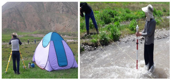
Figure 4.
Surveying in the studied reaches.

Table 4.
The number of surveyed points in studied reaches.
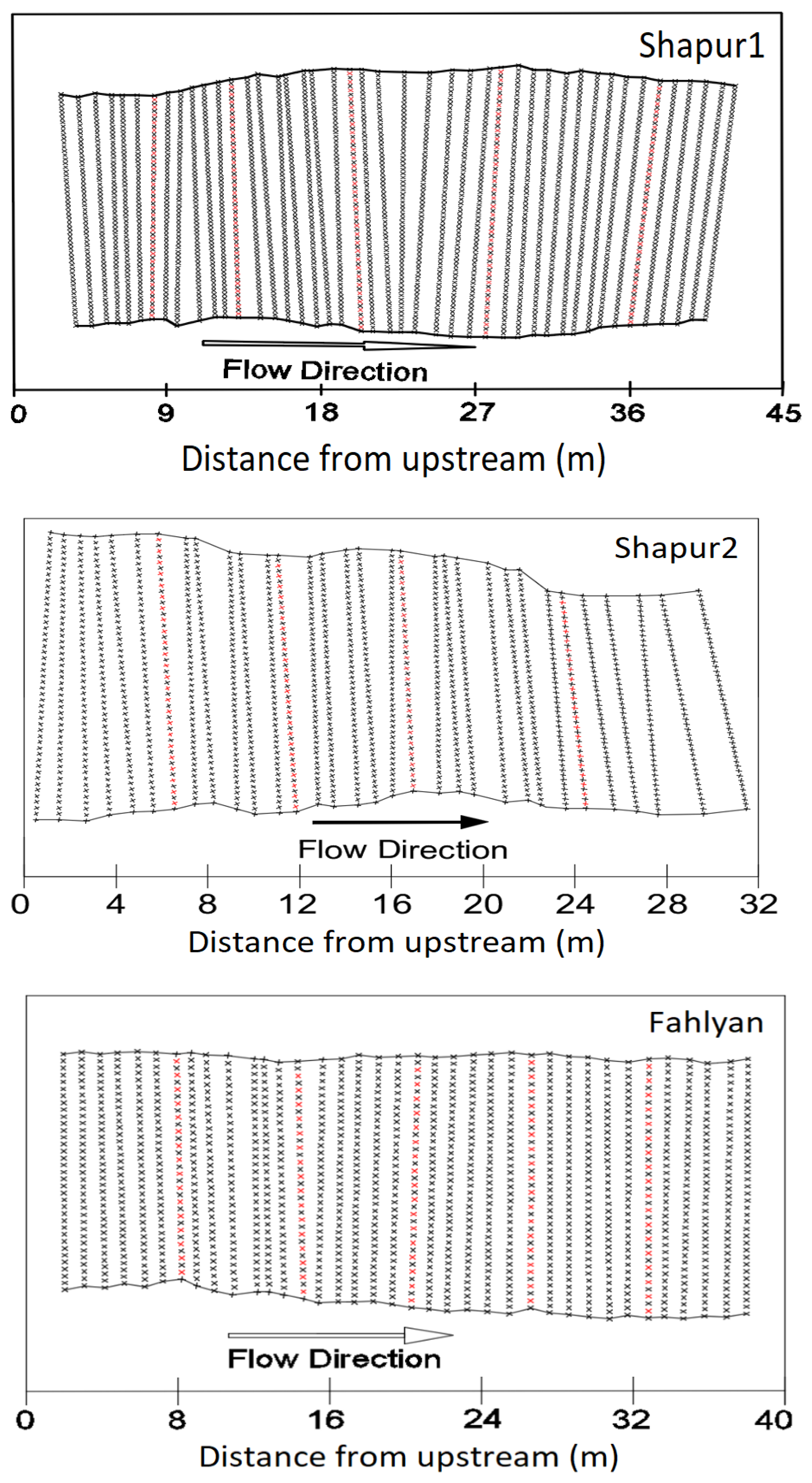
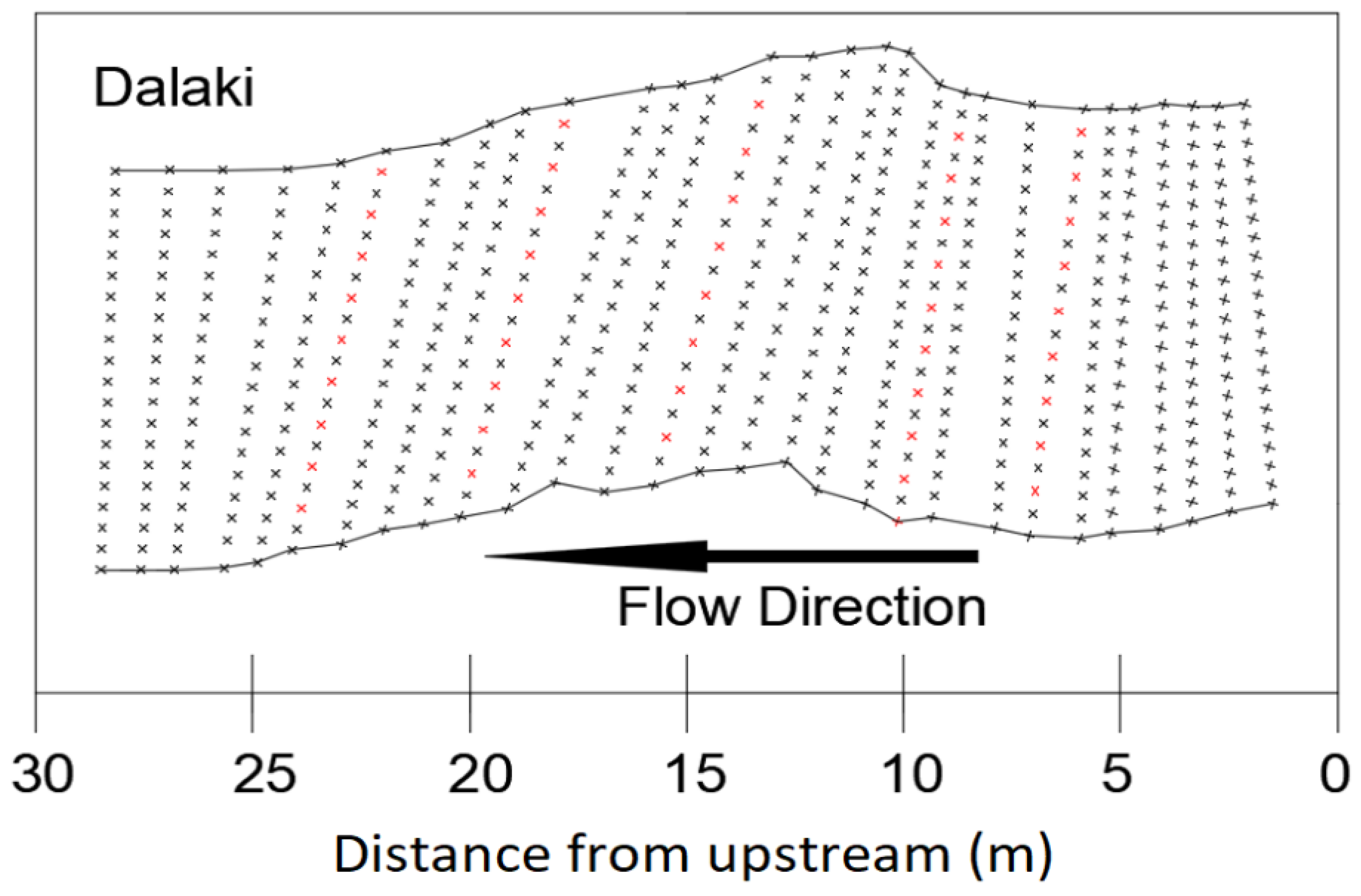
Figure 5 shows images of the plan of selected reaches along with the position of the measured profiles (including two–point and 19–point profiles) and surveyed points. In this figure, the black dots indicate the places where the surveying was done, and in the red dots, the velocity profile was also measured in addition to the surveying. Cross–sections were selected to measure velocity and mapping as perpendicular to the flow direction.
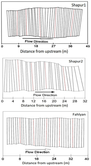
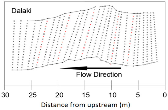
Figure 5.
Plan of the studied reaches along with the position of the measured profiles.
2.3.3. Sampling of Bed Sediments
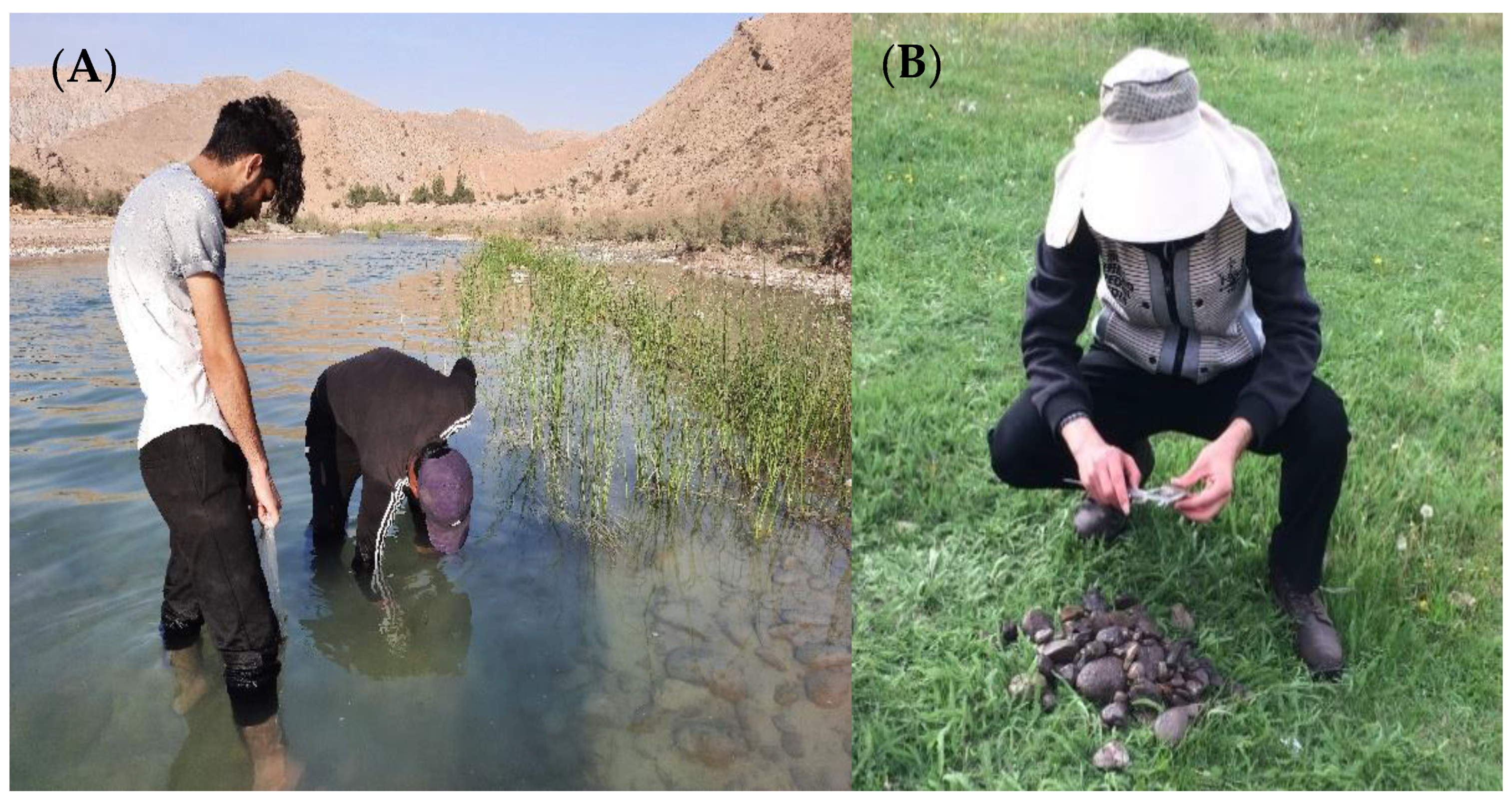
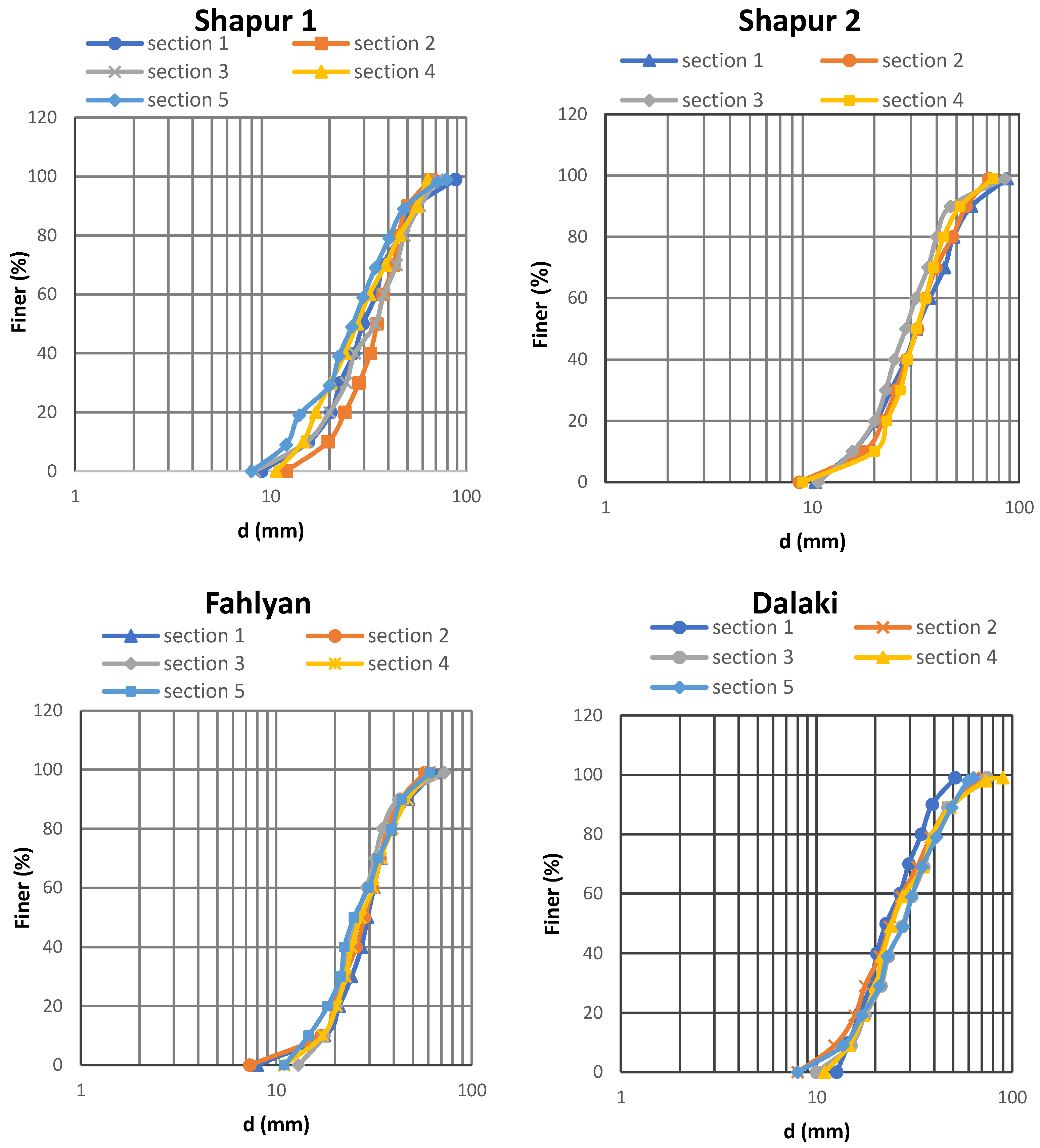
Using Wolman’s method, 100 particles were randomly sampled in each cross–section in the central, left bank, and right bank axes to present grain size distribution (Figure 6 and Figure 7) [32].
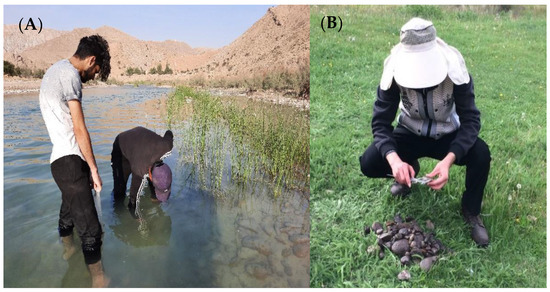
Figure 6.
(A) Sampling of riverbed sediment, (B) measurement of riverbed sediments.
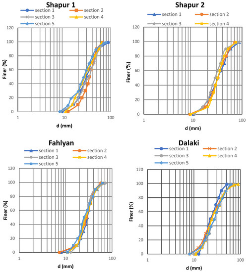
Figure 7.
Grain size distribution in the studied reaches.
2.4. Calculation of Darcy–Weisbach Friction Factor
Bellos (2018) presented a relationship for estimating the Darcy–Weisbach friction factor that is valid for all flow regimes (from laminar to turbulent) and depends on the flow characteristics (water depth and flow velocity) and the roughness height as follows [21]:
where Rh is the Reynolds number of the flow and ks is the roughness height. In this study, the value of ks = 2.4 d90 has been used [30]. The parameters , b, and W(1.35 Rh) are defined as follows:
2.5. The General Framework of This Research
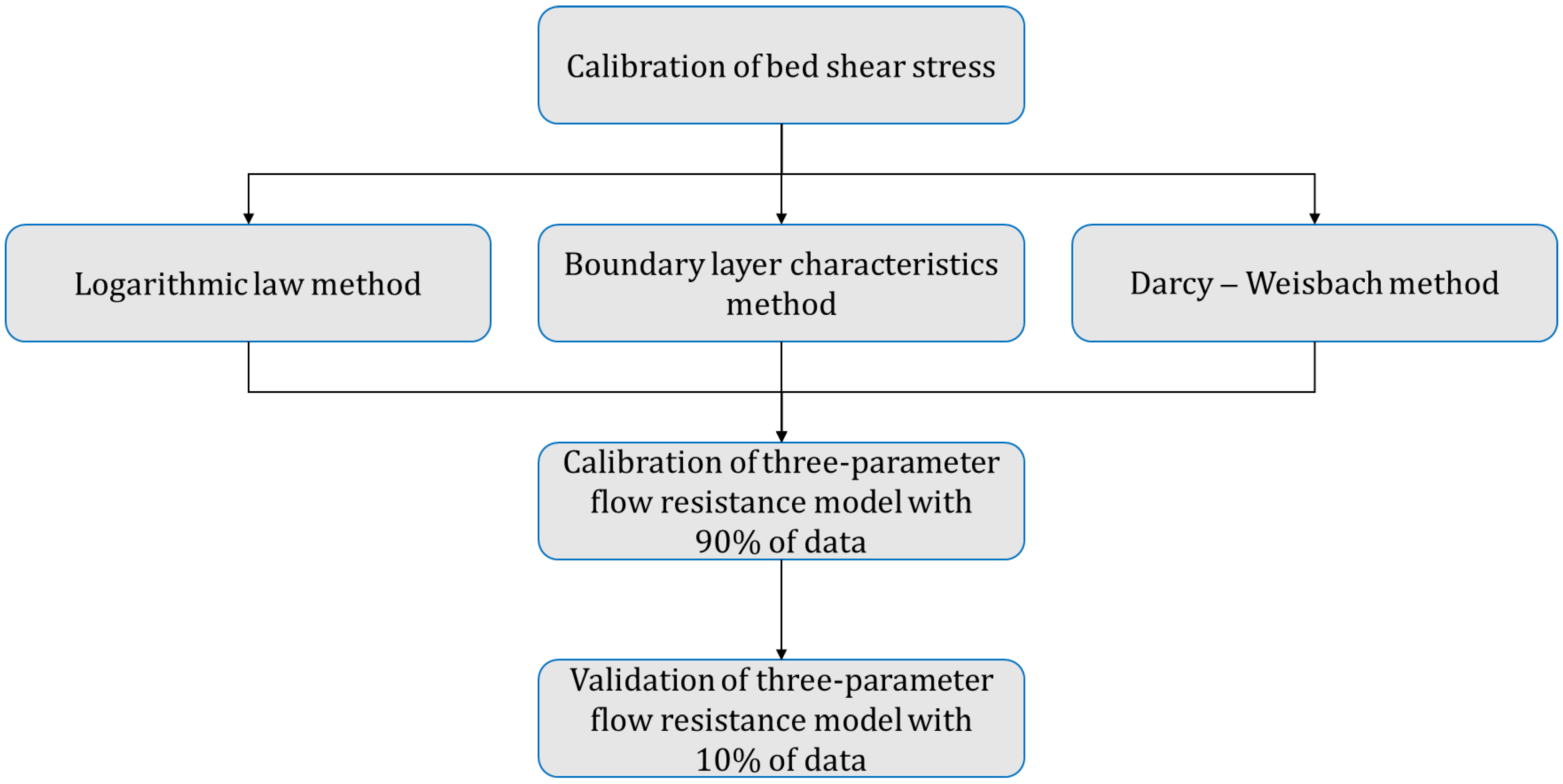
In this research, first, the bed shear stress is calculated using logarithmic law methods, boundary layer characteristics, and the Darcy–Weisbach method. Then, these methods are compared with each other. Finally, the three–parameter flow resistance model is calibrated and validated based on these three methods. Figure 8 shows a summary of the overall research framework.
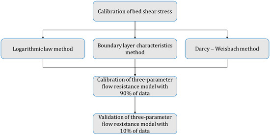
Figure 8.
The general framework of this research.
3. Results and Discussion
3.1. Sediment and Hydraulic Parameters
Sediment and hydraulic parameters of the flow in four selected reaches are presented in Table 5. In the table, D is the hydraulic depth of the flow, Re is the Reynolds number, is the Froude number, and is the geometric standard deviation where d16 and d84 are the grain sizes that are larger than 16% and 84% of the bed material’s mass, respectively. The difference in the amount of discharge in different cross–sections of each reach is due to water supply for agricultural lands and urban irrigation downstream of the selected reaches. The Froude number presented in Table 5 shows that in all cross–sections, this number is less than 1; therefore, the flow in all four studied reaches is sub–critical. The study of more than 100 reaches in Iranian rivers showed that the range of Froude number in mountainous rivers is 0.12 to 0.56, confirming this statement [28]. Moreover, the Reynolds number values show that the flow is turbulent in all four selected reaches. According to Table 5, the particle size distribution of the bed in 74% of the cross–sections is non–uniform where the geometric standard deviation is greater than 1.4 [33].

Table 5.
Sediment and hydraulic parameters of reaches.
3.2. Velocity Profiles
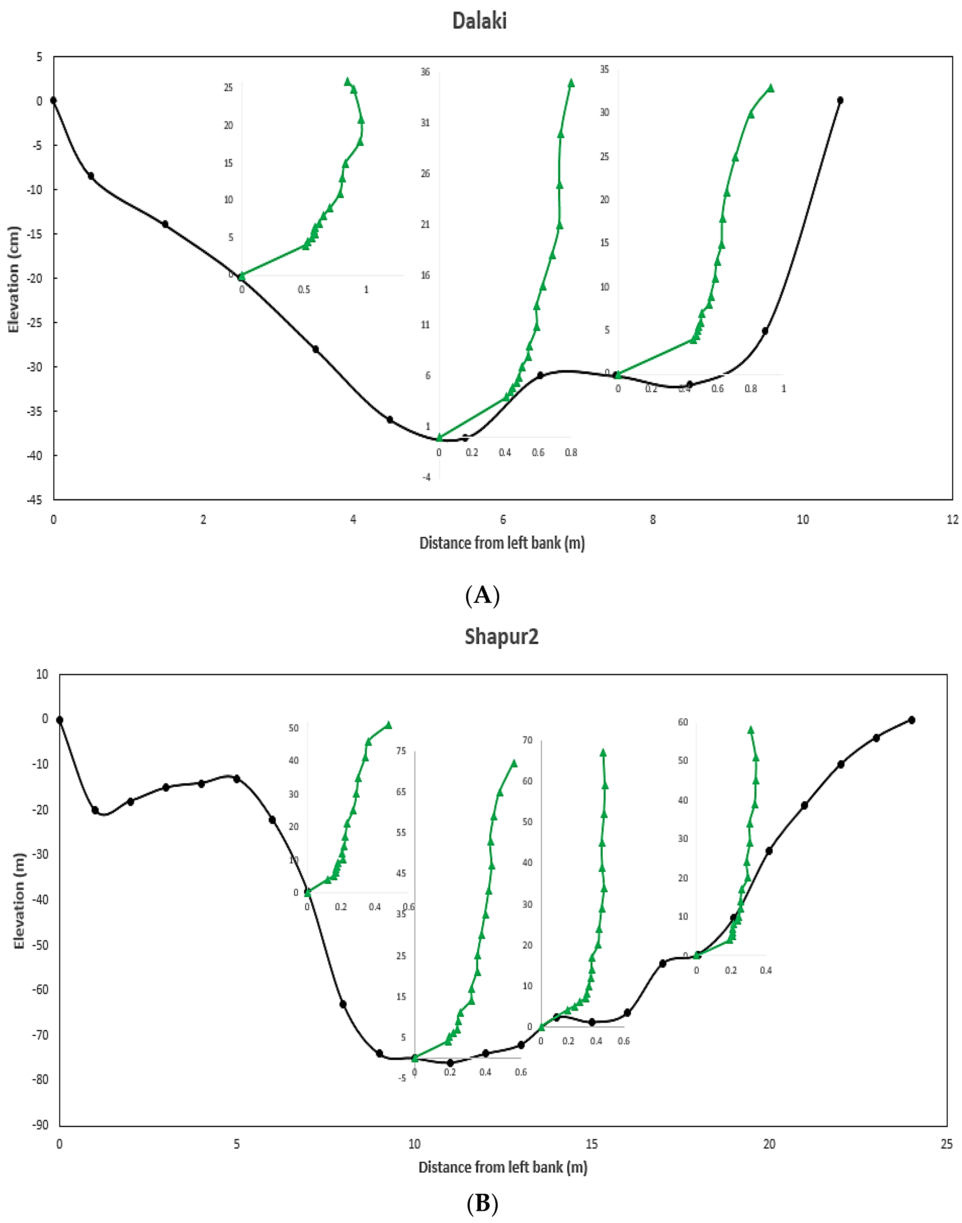
As mentioned, 71 velocity profiles (19 points) were measured in 19 cross–sections in this study. Figure 9 shows the velocity profiles measured in cross–sections number 2 and 4 of the reaches of Dalaki and Shapur2, respectively. In this figure, the unit of velocity is meters per second (m/s). To better investigate the effect of vegetation patches on velocity distribution, more data were collected close to the vegetation patch (See Figure 9A,B). According to Figure 9A, in the profile located on the left bank near the patch of vegetation, the dip phenomenon occurred due to the presence of vegetation and the generation of secondary flows. In this figure, by moving away from the vegetation patch to the right bank, the effect of this phenomenon is decreased, and the velocity distribution illustrates an S–shaped form partly due to variations in the bed sediment. Other researchers have reported S–shaped profiles in other sand and gravel bed streams [34,35].
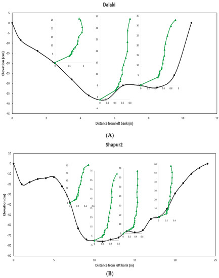
Figure 9.
Cross−section and velocity profiles measured in (A) Section No. 1 from Shapur1; (B) Section No. 2 from Fahlyan reach.
3.3. Validity of Logarithmic Law
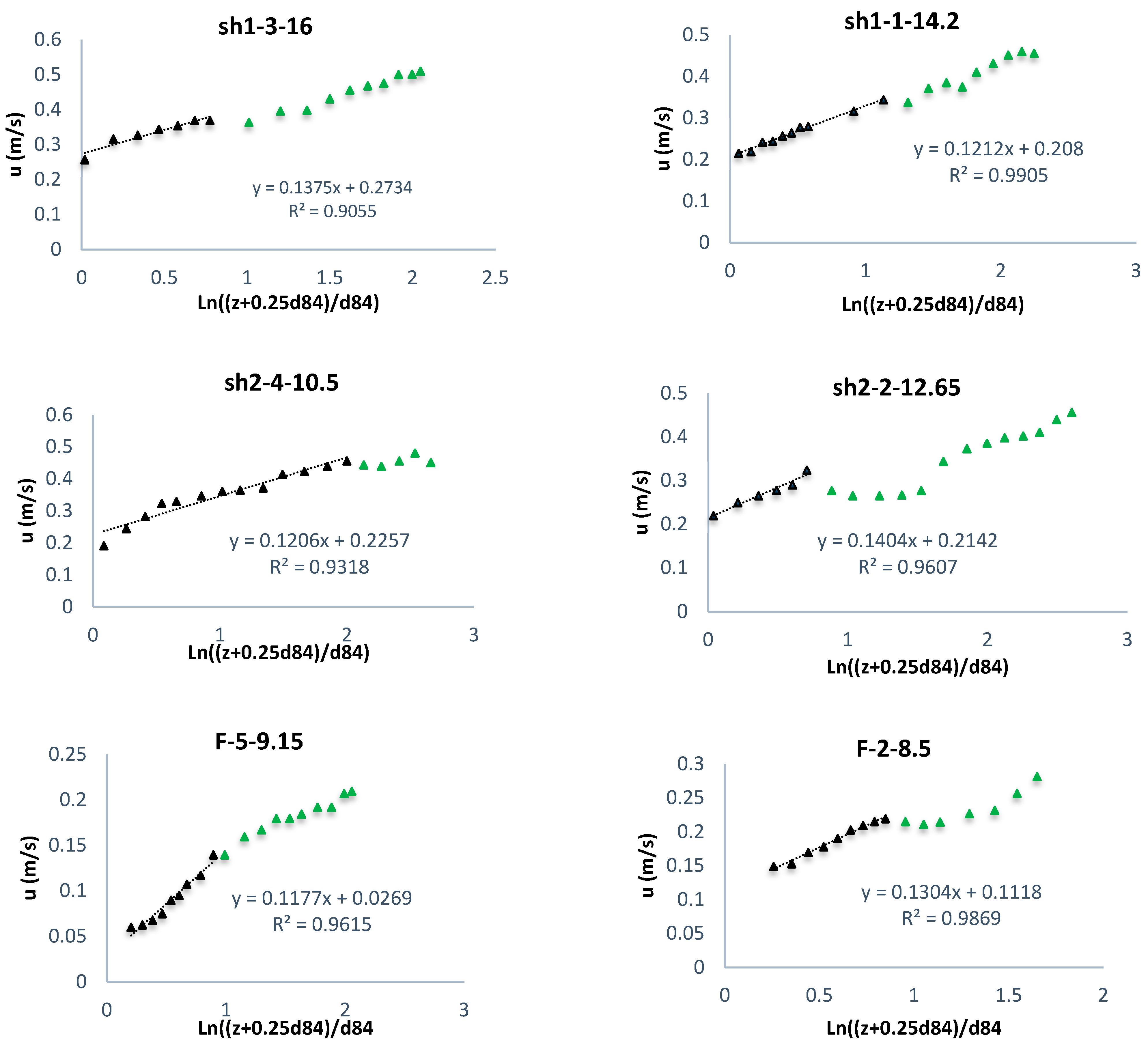
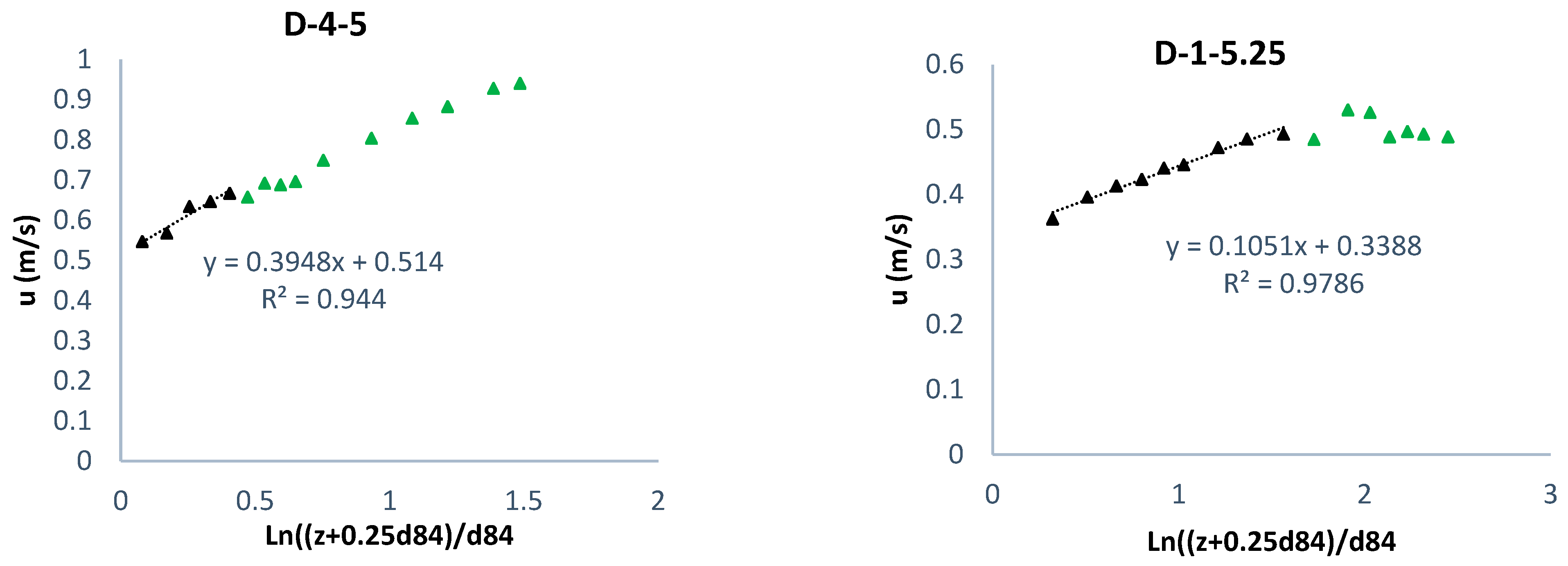
Figure 10 shows the method of determining the validity of the logarithmic law in the profiles of the central axis in the four selected reaches, where the black triangles indicate the fitness of the logarithmic law to the inner layer data and green triangles indicate deviation from the logarithmic law in the outer layer. In the figure, the profiles are named as (reach name-cross-section number-distance from the right bank). For example, Sh1_1_14.2 shows the existing profile in Shapur1 reach and the cross-section of No. 1 at a distance of 14.2 m from the right bank. According to Figure 10, the coefficient of determination values (R2) in all profiles are more than 90%, indicating the reasonable agreement of the logarithmic law with the measured data in the inner layer. Investigation of the logarithmic law in velocity profiles showed that the profiles located on the crest of the bedform (e.g., Sh1-3-16 and F-4-10) are more irregular than the profiles of the concave region of the bedform (e.g., Sh1-1-14.2 and D-2-5.25). Moreover, the coefficient of determination values (R2) related to the logarithmic law fit in these profiles was less than the profiles of the concave region. This could be due to a sudden increase in velocity on the crest of the bedform and the occurrence of the flow separation zone downstream of the crest [36]. In profiles where the outer layer data are below the regression line, the favorable pressure gradient () is dominant, and if the deviation is above the regression line, the adverse pressure gradient ) is dominant. According to this figure, in most profiles, the deviation of the outer layer data is below the regression line, indicating the dominance of the adverse pressure gradient ) due to increasing turbulence [37].
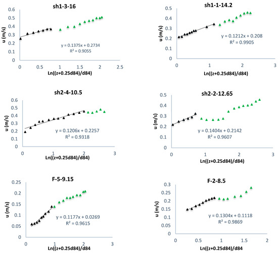
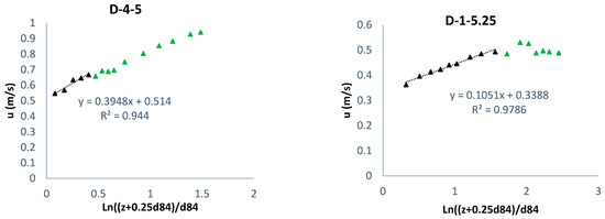
Figure 10.
Determining the validity of the logarithmic law in the profiles in the central axis from four selected reaches.
3.4. Calculation of Shear Velocity
River engineers use indirect methods to estimate the bed shear stress. Three methods of boundary layer (BL) characteristics, logarithmic law, and Darcy–Weisbach (DW) were used to estimate the bed shear in this study. Table 6 shows the bed shear stress values calculated using these three methods. The values of the Darcy–Weisbach friction factor in the table were obtained using the method of Bellos et al. (Equations (15)–(18)). Due to the large Reynolds number in the selected reaches, the values of and b in Equations (16) and (17) are almost equal to zero, which makes the first and second terms of Equation (15) approximately equal to one. Therefore, the Darcy–Weisbach friction factor depends only on the flow depth and roughness height. For this reason, in Table 6, profiles with the same cross–section and depth (for example, profiles Sh1_2_10 and Sh1_2_15) have an equal friction factor.

Table 6.
Shear velocity and shear stress of the substrate calculated by different methods.
Comparing the shear velocity calculated with three different methods in Table 6 shows that:
- The logarithmic law method reveals the highest range of changes in estimating the shear velocity due to the sensitivity of this method to adjusting the reference level and using the velocity variation near the bed. However, the Darcy–Weisbach method shows the lowest range of changes in shear velocity estimation because it uses all data measured in a velocity profile.
- The boundary layer characteristics method is reliable in coarse–grained rivers for calculating shear velocity [23] because it considers all velocity data in each profile. It was found that the relative differences between the logarithmic law and Darcy–Weisbach methods compared to the boundary layer characteristics method are equal to 87% and 39%, respectively, which indicates more reasonable agreement between Darcy–Weisbach method and the boundary layer characteristics method.
In this research, the relative difference in the percentage of the logarithmic law and Darcy–Weisbach methods was calculated and compared to the boundary layer characteristics using the following equation:
where n is the total number of data.
3.5. Calibration of Three–Parameter Flow Resistance Model
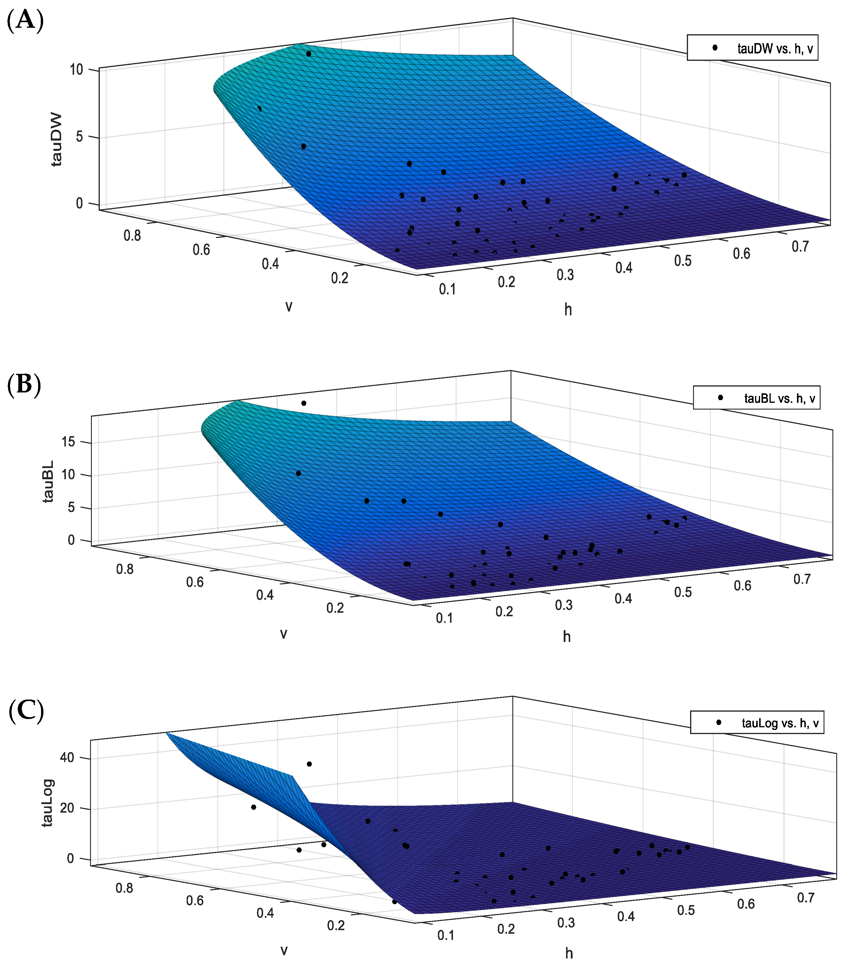
The three–parameter flow resistance model presented in Equation (3) has two independent variables (depth and flow velocity ) and three constant parameters (). After calculating the shear velocity using the three methods, the constant parameters (A, B, C) of the three–parameter flow resistance model were determined through the best fit between the results obtained from each method and the results of the three–parameter flow resistance model. This was done using the MATLAB software curve fitting toolbox.
In this study, 90% of the profiles (64 profiles) were used for calibration, and 10% (7 profiles) were used to validate the three–parameter flow resistance model. Table 7 shows the calibration results of the mentioned model using three methods of boundary layer characteristics, logarithmic law, and Darcy–Weisbach. According to the table, the Darcy–Weisbach method has the highest coefficient of determination (R2) and the lowest root mean square error (RMSE), suggesting the ability of the Darcy–Weisbach method to calibrate the three–parameter flow resistance model compared to other methods. In addition, the logarithmic law method has the lowest coefficient of determination (R2) and the highest root mean square error (RMSE), revealing the low accuracy of the logarithmic law method for calibrating the three–parameter flow resistance model. The value of coefficient A (velocity power) obtained using Darcy–Weisbach method and the boundary layer characteristics are close to each other due to the use of all points of the velocity profile. Figure 11 shows the fitted surface on the data obtained using the three methods.

Table 7.
Calibration results of three–parameter resistance model using three different methods.
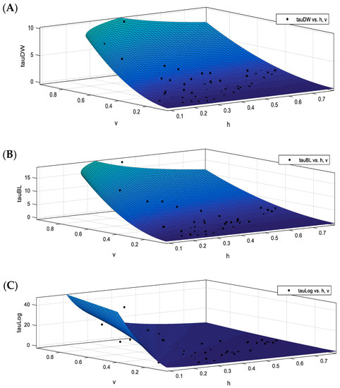
Figure 11.
Surface fitted on the data obtained using the methods (A) Darcy–Weisbach, (B) boundary layer characteristics, (C) logarithmic law.
3.6. Validation of Three–Parameter Flow Resistance Model
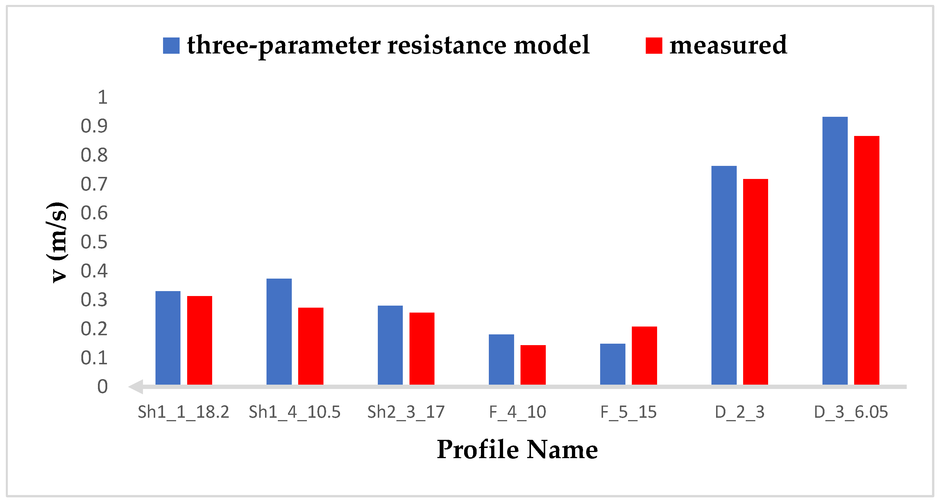
Since it is difficult to measure the bed shear stress in field research directly, it is impractical to calculate the model accuracy by comparing the bed shear stress calculated with the measured one. Therefore, to validate and calculate the model accuracy in this study, the amount of flow velocity calculated by the model (Equation (4)) was compared with the flow velocity measured by the current meter. Since the Darcy–Weisbach method has the highest accuracy in model calibration, only the calibration results using this method were used to validate the model. As mentioned, 10% of the velocity profiles (7 profiles) were used to validate and calculate the model accuracy. In Figure 12, the velocity value calculated using the three–parameter flow resistance model is compared with the velocity values measured by the current meter. According to this figure, the three–parameter flow resistance model in 6 of 7 profiles (86%) estimates values higher than the measured values. The average error of the model was calculated to be 17%, which indicates the high accuracy of the model in estimating the velocity and consequently the bed shear stress. It should be noted that up to 200% error is acceptable in estimating certain fluvial parameters [38]. Reasons for accepting this amount of error in river engineering are:
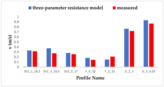
Figure 12.
Comparison between the velocity calculated from the model with the measured velocity.
- Difficulty working in the river with rough bed and non–uniform flow;
- Difficulty working with high–precision measuring instruments in field research;
- Not recognizing all the factors affecting error production;
- Assumptions and simplifications performed that generate errors.
4. Conclusions
Resistance to flow is a key parameter in river engineering studies and its estimation plays a significant role in engineering models. Accordingly, in this study, resistance to flow was estimated in four reaches of coarse–bed rivers with vegetation patches using three methods of boundary layer characteristics, logarithmic law, and Darcy–Weisbach. In addition, the coefficients of the three–parameter flow resistance model (A, B, C) were calibrated based on these three methods using 90% of the data. In summary, the following results can be presented:
- The three–parameter flow resistance model shows that the average error percentage of the model is 17%, indicating the accuracy of the model.
- The logarithmic law method has the highest range of changes in estimating the bed shear stress compared to the methods of Darcy–Weisbach and the boundary layer characteristics method. This is due to the sensitivity of the logarithmic law method to adjusting the reference surface and using the near bed data of the velocity profile. The Darcy–Weisbach method reveals the lowest range of changes.
- The relative difference percentages between the logarithmic law and the Darcy–Weisbach methods compared to the boundary layer characteristics method were equal to 87% and 39%, respectively. This indicated a more reasonable agreement between the Darcy–Weisbach method and the boundary layer characteristics method.
- By investigating 71 measured velocity profiles, it was found that the logarithmic law was well applicable in reaches with vegetation patches. A high coefficient of determination () in fitting the velocity profile data to the logarithmic law indicated their reasonable agreement with this law.
- The investigation of measured velocity profiles shows the occurrence of the Dip phenomenon in the velocity profiles near the vegetation patches. However, by moving away from the vegetation patches, the effect of this phenomenon is decreased, and the profiles illustrate an S–shaped distribution. The Dip location plays a significant role in the boundary layer thickness and estimation of key hydraulic parameters.
The results of this study can be used in many environmental models, including fluvial geomorphology, and mountain rivers with vegetation patches in order to improve the flow resistance evaluation and its application in hydraulic models.
Author Contributions
Conceptualization, H.A.; methodology, H.A. and A.D.; software, M.N.; validation, H.A., A.D. and N.D.; investigation, M.N.; resources, H.A. and A.D.; data curation, M.N.; writing—original draft preparation, M.N. and H.A.; writing—review and editing, M.N.-S. and M.K.; visualization, M.N.; supervision, H.A., A.D., N.D., M.N.-S. and M.K.; All authors have read and agreed to the published version of the manuscript.
Funding
This research received no external funding.
Institutional Review Board Statement
Not applicable.
Informed Consent Statement
Not applicable.
Data Availability Statement
The data are available upon request.
Conflicts of Interest
The authors declare no conflict of interest.
References
- Wang, J.; Shi, F.-Y.; Chen, P.-P.; Wu, P.; Sui, J. Impact of bridge pier on the stability of ice jam. J. Hydrodyn. 2015, 27, 865–871. [Google Scholar] [CrossRef]
- Folkard, A.M. Vegetated flows in their environmental context: A review. Proc. Inst. Civ. Eng. Eng. Comput. Mech. 2011, 164, 3–24. [Google Scholar] [CrossRef]
- Marion, A.; Nikora, V.; Puijalon, S.; Bouma, T.; Koll, K.; Ballio, F.; Tait, S.; Zaramella, M.; Sukhodolov, A.; O’Hare, M. Aquatic interfaces: A hydrodynamic and ecological perspective. J. Hydraul. Res. 2014, 52, 744–758. [Google Scholar] [CrossRef]
- Kothyari, U.C.; Hayashi, K.; Hashimoto, H. Drag coefficient of unsubmerged rigid vegetation stems in open channel flows. J. Hydraul. Res. 2009, 47, 691–699. [Google Scholar] [CrossRef]
- Palmer, M.R.; Nepf, H.M.; Pettersson, T.J.; Ackerman, J.D. Observations of particle capture on a cylindrical collector: Implications for particle accumulation and removal in aquatic systems. Limnol. Oceanogr. 2004, 49, 76–85. [Google Scholar] [CrossRef] [Green Version]
- López, F.; García, M. Open-channel flow through simulated vegetation: Suspended sediment transport modeling. Water Resour. Res. 1998, 34, 2341–2352. [Google Scholar] [CrossRef]
- Cotton, J.; Wharton, G.; Bass, J.; Heppell, C.; Wotton, R. The effects of seasonal changes to in-stream vegetation cover on patterns of flow and accumulation of sediment. Geomorphology 2006, 77, 320–334. [Google Scholar] [CrossRef]
- Setayesh, P.; Afzalimehr, H. Effect of Reedy Emergent Side-Vegetation in Gravel-Bed Streams on Bed Shear Stress: Patch Scale Analysis. Iran. J. Sci. Technol. Trans. Civ. Eng. 2021, 46, 1375–1392. [Google Scholar] [CrossRef]
- Shahmohammadi, R.; Afzalimehr, H.; Sui, J. Impacts of turbulent flow over a channel bed with a vegetation patch on the incipient motion of sediment. Can. J. Civ. Eng. 2018, 45, 803–816. [Google Scholar] [CrossRef]
- Liu, X.-D.; Tang, L.-C.; Han, Y.; Chen, J.; Yang, S.-Q. Experimental study on flow resistance over rigid vegetated channel. IEEE Access 2019, 7, 93974–93985. [Google Scholar] [CrossRef]
- Kazem, M.; Afzalimehr, H.; Sui, J. Formation of Coherent Flow Structures beyond Vegetation Patches in Channel. Water 2021, 13, 2812. [Google Scholar] [CrossRef]
- Green, J.C. Comparison of blockage factors in modelling the resistance of channels containing submerged macrophytes. River Res. Appl. 2005, 21, 671–686. [Google Scholar] [CrossRef]
- Thoman, R.W.; Niezgoda, S.L. Determining erodibility, critical shear stress, and allowable discharge estimates for cohesive channels: Case study in the Powder River basin of Wyoming. J. Hydraul. Eng. 2008, 134, 1677–1687. [Google Scholar] [CrossRef]
- Box, W.; Järvelä, J.; Västilä, K. Flow resistance of floodplain vegetation mixtures for modelling river flows. J. Hydrol. 2021, 601, 126593. [Google Scholar] [CrossRef]
- Van Dijk, W.; Teske, R.; Van de Lageweg, W.; Kleinhans, M. Effects of vegetation distribution on experimental river channel dynamics. Water Resour. Res. 2013, 49, 7558–7574. [Google Scholar] [CrossRef] [Green Version]
- Shields, F.D.; Coulton, K.G.; Nepf, H. Representation of Vegetation in Two-Dimensional Hydrodynamic Models. J. Hydraul. Eng. 2017, 143, 8. [Google Scholar] [CrossRef] [Green Version]
- Nosrati, K.; Afzalimehr, H.; Sui, J. Drag Coefficient of Submerged Flexible Vegetation Patches in Gravel Bed Rivers. Water 2022, 14, 743. [Google Scholar] [CrossRef]
- Afzalimehr, H.; Barahimi, M.; Sui, J. Non-uniform flow over cobble bed with submerged vegetation strip. Proc. Inst. Civ. Eng. Water Manag. 2019, 172, 86–101. [Google Scholar] [CrossRef] [Green Version]
- Ferguson, R. Time to abandon the Manning equation? Earth Surf. Processes Landf. 2010, 35, 1873–1876. [Google Scholar] [CrossRef]
- Afzalimehr, H.; Levesque, B.; Molls, T.; Zhao, G.; Molls, F. Friction Slope in Depth-Averaged Flow. J. Hydraul. Eng. 1999, 125, 549. [Google Scholar] [CrossRef]
- Bellos, V.; Nalbantis, I.; Tsakiris, G. Friction modeling of flood flow simulations. J. Hydraul. Eng. 2018, 144, 04018073. [Google Scholar] [CrossRef] [Green Version]
- Afzalimehr, H.; Anctil, F. Accelerating shear velocity in gravel-bed channels. Hydrol. Sci. J. 2000, 45, 113–124. [Google Scholar] [CrossRef] [Green Version]
- Afzalimehr, H.; Rennie, C.D. Determination of bed shear stress in gravel-bed rivers using boundary-layer parameters. Hydrol. Sci. J. 2009, 54, 147–159. [Google Scholar] [CrossRef] [Green Version]
- Afzalimehr, H.; Maddahi, M.R.; Naziri, D.; Sui, J. Effects of non-submerged boulder on flow characteristics—A field investigation. Int. J. Sediment Res. 2019, 34, 136–143. [Google Scholar] [CrossRef]
- Afzalimehr, H.; Maddahi, M.R.; Sui, J.; Rahimpour, M. Impacts of vegetation over bedforms on flow characteristics in gravel-bed rivers. J. Hydrodyn. 2019, 31, 986–998. [Google Scholar] [CrossRef]
- Emadzadeh, A.; Chiew, Y.M.; Afzalimehr, H. Effect of accelerating and decelerating flows on incipient motion in sand bed streams. Adv. Water Resour. 2010, 33, 1094–1104. [Google Scholar] [CrossRef]
- Fazlollahi, A.; Afzalimehr, H.; Haghighi, A.; Barati, R.; Neyshabouri, S.A.A.S.; Ahmadi, G.; Omidvar, P.; Kheirkhahan, M.; Hosseini, K.; Kabiri-Samani, A. 101. Validation of Spatially Averaging Method for Using the Law of the Wall over Concave Bed Form (pool). SMR 2007, 2, 27–42. [Google Scholar]
- Naderi, M.; Afzalimehr, H.; Sohrabi, S. Investigation of three-parameter flow resistance model in coarse-bed rivers (Case study: Deryuk River). Iran. J. Soil Water Res. 2021, 52, 1423–1435. [Google Scholar]
- Song, T.; Chiew, Y. Turbulence measurement in nonuniform open-channel flow using acoustic Doppler velocimeter (ADV). J. Eng. Mech. 2001, 127, 219–232. [Google Scholar] [CrossRef]
- Alonso, R.L.; Fernández, J.B.; Cugat, M.C. Flow resistance equations for mountain rivers. For. Syst. 2009, 18, 81–91. [Google Scholar]
- Brierley, G.J.; Fryirs, K.A. Geomorphology and River Management: Applications of the River Styles Framework; John Wiley & Sons: Hoboken, NJ, USA, 2013. [Google Scholar]
- Wolman, M.G. A method of sampling coarse river-bed material. EOS Trans. Am. Geophys. Union 1954, 35, 951–956. [Google Scholar] [CrossRef]
- Okhravi, S.; Gohari, S. Form friction factor of armored riverbeds. Can. J. Civ. Eng. 2020, 47, 1238–1248. [Google Scholar] [CrossRef]
- Afzalimehr, H.; Ramazany, R. Validation of Double-Averaged Velocity Method for Decelerating Flow in Coarse-Bed Rivers. J. Hydraul. 2019, 2, 47–67. [Google Scholar]
- Afzalimehr, H.; Subhasish, D. Influence of bank vegetation and gravel bed on velocity and Reynolds stress distributions. Int. J. Sediment Res. 2009, 24, 236–246. [Google Scholar] [CrossRef]
- Maddahi, M.R.; Afzalimehr, H.; Rowinski, P.M. Flow characteristics over a gravel bedform: Kaj River case study. Acta Geophys. 2016, 64, 1779–1796. [Google Scholar] [CrossRef] [Green Version]
- Houra, T.; Tsuji, T.; Nagano, Y. Effects of adverse pressure gradient on quasi-coherent structures in turbulent boundary layer. Int. J. Heat Fluid Flow 2000, 21, 304–311. [Google Scholar] [CrossRef]
- Wu, B.; Molinas, A.; Julien, P.Y. Bed-material load computations for nonuniform sediments. J. Hydraul. Eng. 2004, 130, 1002–1012. [Google Scholar] [CrossRef]
Publisher’s Note: MDPI stays neutral with regard to jurisdictional claims in published maps and institutional affiliations. |
© 2022 by the authors. Licensee MDPI, Basel, Switzerland. This article is an open access article distributed under the terms and conditions of the Creative Commons Attribution (CC BY) license (https://creativecommons.org/licenses/by/4.0/).

