

A Systematic Review and Bibliometric Analysis of Wildland Fire Behavior Modeling

 ,
,  ,
,  and
and
Abstract
1. Introduction
2. Systematic Review
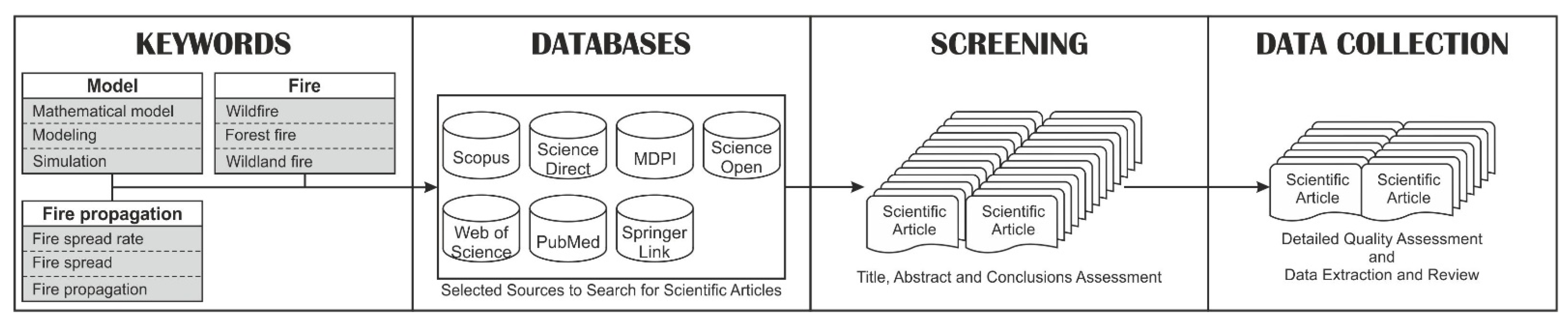
2.1. Methodology
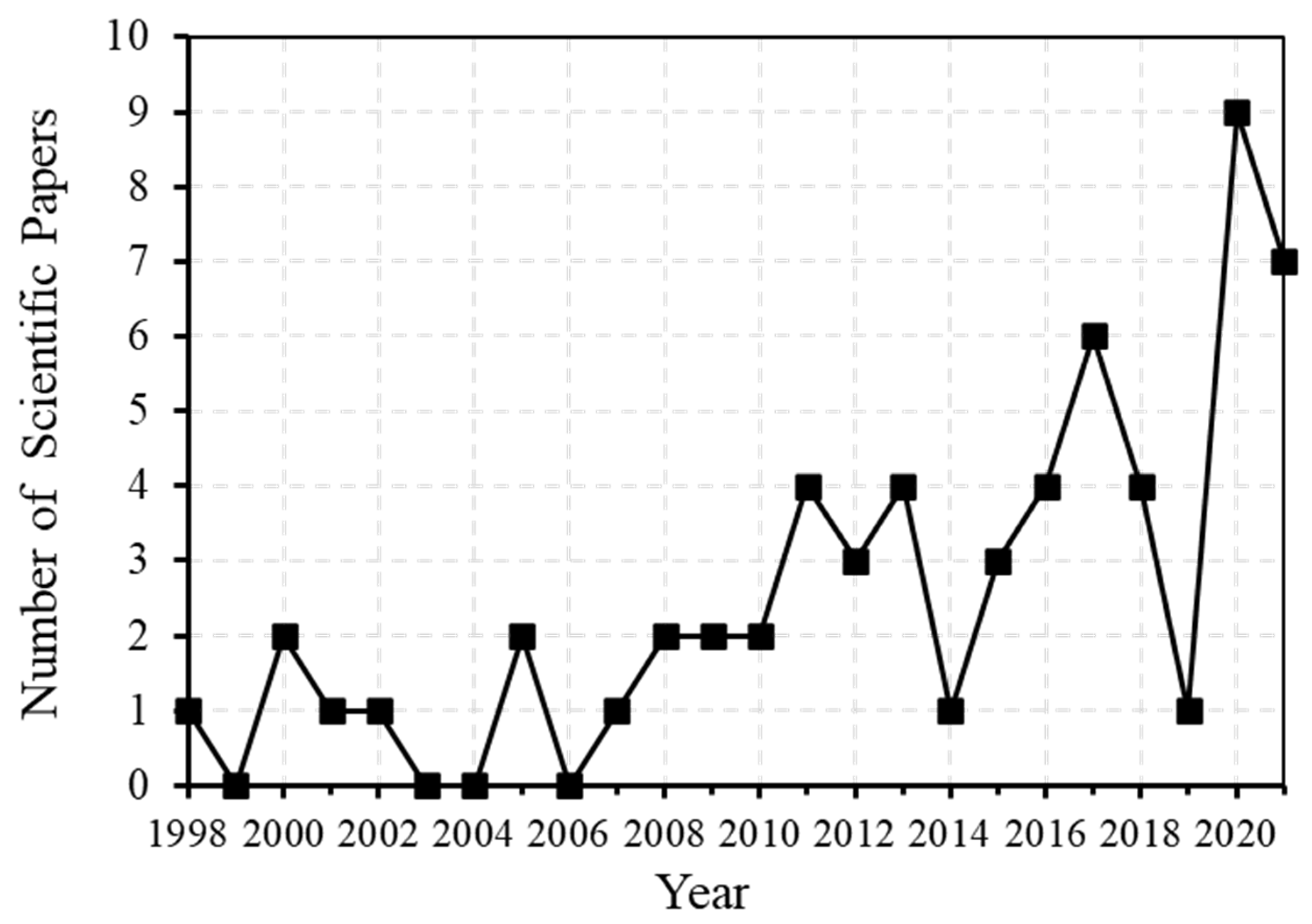
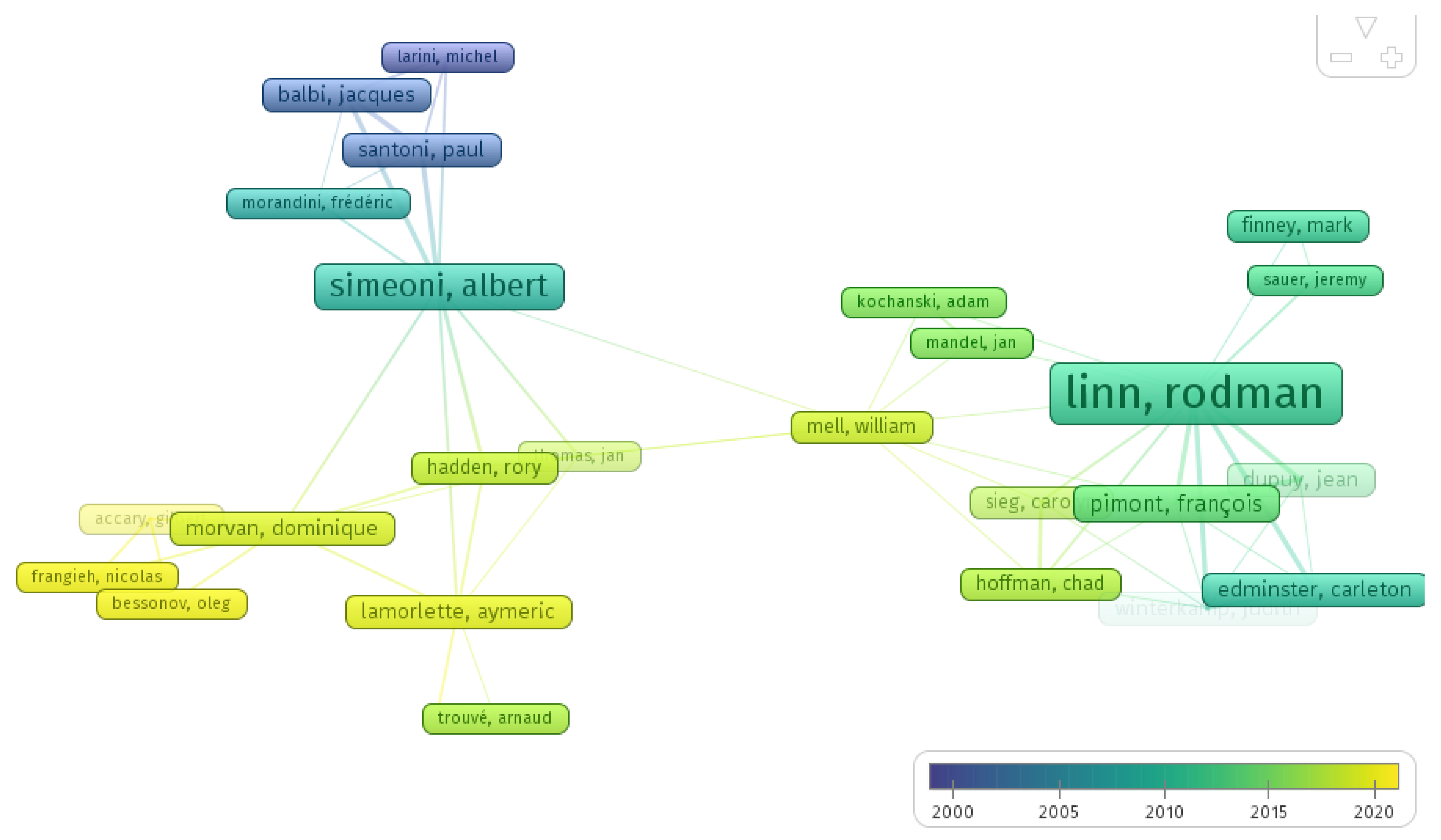
2.2. Overview of the Literature
3. General Trends from Modeling the Wildfire Behavior
3.1. Summary

| Author | Key Aspects | Main Conclusions | Validation |
|---|---|---|---|
| Allaire et al., 2021 [26] | Provides a method to generate a probabilistic forecast of a burned area. | The calibrated ensembles lead to better overall accuracy. | Simulation |
| Aedo and Bonilla, 2021 [27] | Development of a numerical model to predict the loss of soil organic matter. | The soil water content controlled the heat consumed during vaporization and prevented soil decay. | Simulation |
| Jiang et al., 2021 [28] | Development of a fire spread model based on the heterogeneous cellular automata model. | The model can generate fire spread predictions with acceptable accuracy and short running time. | Simulation |
| Allaire et al., 2020 [29] | Prediction of surface fire spread and focus on the uncertainty. | Fire danger maps can be developed based on probabilistic fire simulations. | Simulation |
| Yuan et al., 2020 [30] | Development of parametric uncertainty analysis in an upslope fire spread model. | Values of ignition and flame temperatures have significant impacts on the predicted values of ROS under lower slopes. | Simulation |
| Rossa and Fernandes, 2018 [31] | Development of two empirical functions for ROS under windless conditions. | Both models confirm that independent variables are adequate descriptors of ROS. | Simulation |
| Rossa and Fernandes, 2018 [32] | Development of an empirical model for wind-aided ROS. | Laboratory evaluation showed improved predictions concerning the Rothermel model. | Experiments |
| Matthieu et al., 2017 [33] | Development of a fire spread model based on raster implementation. | The model can overpredict the spread rate of fire on the flanks. | Simulation |
| Hilton et al., 2015 [34] | Implementation of a wildfire spread model based on the level set method. | Local variation in combustion conditions slows the rate of propagation. | Simulation |
| Simeoni et al., 2015 [35] | Proposes an algorithm to accelerate the solution of the semi-physical model. | The accuracy of the results is not affected by this algorithm. | Experiments |
| Rochoux et al., 2013 [36] | Presentation of the potential benefits of data assimilation techniques. | Data assimilation has the potential to dramatically increase fire simulation accuracy. | Experiments and Observations |
| Simeoni et al., 2011 [37] | Study the fire spreading through a heterogeneous medium with a 2D reaction–diffusion physical model. | Combining different processes to create heterogeneity and improves the efficiency of heterogeneous zones to describe fire behavior. | Simulation |
| Mallet et al., 2009 [38] | Focus on a minimalist treatment of the fire front. | ROS depends on the wind speed and the angle between wind direction and the normal to the fire front. | Simulation |
| Johnston et al., 2008 [16] | Presentation of a cell-based wildfire simulator that uses an irregular grid. | Faster than traditional fire front propagation schemes. | Simulation |
| Morandini et al., 2005 [39] | Proposes a 2D nonstationary model of fire spreading across a fuel bed. | The model provided good results but should be tested in more realistic conditions. | Experiments |
| Simeoni et al., 2001 [40] | Study the advection effect on the fire spread across a fuel bed. | The knowledge of the gas velocity distribution proved to be essential to ROS. | Experiments |
| Simeoni et al., 2001 [41] | Improvement of semi-physical fire spread models based on the multiphase concept and a single equation. | Adding the advection term implies that the fire can theoretically spread faster than the wind. | Experiments |
| Author | Key Aspects | Main Conclusions | Validation |
|---|---|---|---|
| Valero et al., 2021 [54] | Exploration of multi-fidelity approaches to fire spread prediction. | Fuel moisture, fuel load, and wind speed are the uncertainties responsible for most of the variation in fire rate of spread. | Experiments |
| Mueller et al., 2021 [56] | Considers the level of detail used to describe the environment and the predicted fire behavior. | Increasing the detail in canopy fuel structure and implementing turbulent boundary conditions at the domain had a minor impact. | Experiments |
| Atchley et al., 2021 [58] | Investigation of how fuel density fidelity and heterogeneity shape effective wind characteristics affect fire behavior. | Incorporating high-resolution fuel fidelity and heterogeneity information is crucial to capture effective wind conditions. | - |
| Zhang and Lamorlette, 2020 [57] | Considers the effect of vegetation characteristics on the flame tilt angle and the radiative heat transfer. | Predicts free and non-free fires, proposing a new tilt angle model and a new model for radiative heat power reaching the vegetation. | Simulation |
| Zhang et al., 2020 [50] | Investigate fire regime transition and its associated heat transfer mechanisms. | The new configuration is considered more suitable for investigating the fire regime transition. | Simulation |
| Linn et al., 2020 [43] | A new simulation tool to rapidly solve fire–atmospheric feedback. | Capability to capture basic trends in fire behavior, the response of fire spread to the size of the fire, and consumption of canopy fuels. | Compared with other models |
| Agranat and Perminov, 2020 [48] | A multiphase model is developed and incorporated into PHOENICS. | The predicted ROS agreed well with experimental values obtained at various wind speeds. | Experiments |
| Frangieh etal., 2020 [51] | Study of the 3D structure of a fire front propagating. | While in low wind speed, plumes rise and are not visibly affected by the action of crosswind, in stronger winds, they crossfire in front. | Experiments |
| Lopes et al., 2019 [52] | Two-way coupling method for fire behavior prediction. | Buoyancy-modified wind field should be considered as an input in fire prediction models. | Real fire data |
| Frangieh et al., 2018 [53] | A fully multiphase model that was developed can predict the fire ROS numerically. | Fire ignition can affect the shape of the fire front without significantly affecting ROS | Experiments |
| Chen et al., 2018 [59] | The model includes pyrolysis coupled with detailed chemistry combustion. | Enabled gas-phase fluid interactions, and combustion products/smoke formation, considering the radiation feedback on the solid fuel interface. | Experiments |
| Desmond et al., 2017 [60] | Replication of experiments in a wind tunnel. | Inclusion of forestry and buoyancy effects in CFD using sources and sink terms. | Experiments |
| Lopes et al., 2017 [45] | Describes an evolution of FireStation, incorporating a wind calculation module that considers feedback. | The two-way coupling importance decreases as the fire area gets larger. Update frequency influences the calculation time. | Simulation |
| Houssami et al., 2016 [61] | Presents a method for controlling the behavior of porous wildland fuels. | It was possible to reproduce the mass loss and temperatures that agree with the experiments. | Experiments and Simulation |
| Hoffman et al., 2015 [62] | Development of empirical relations between wind speed and crown fire. | Values from physics-based models fell within the 95% prediction interval of the empirical data. | Simulation |
| Canfield et al., 2014 [49] | Study of factors that connect fire line length, geometry, and ROS. | Increased ignition line length of simulated grass fires leads to increased ROS. | Simulation |
| Satoh et al., 2013 [63] | Study of the termination of fire whirls by means of aerial firefighting. | Fire extinguishment in the boundary is affected by the heat release rate of houses, wind speed, and location of a large structure. | Simulation |
| Linn et al., 2013 [64] | Exploration of fire/vegetation/atmosphere interactions. | Sparse fuels in heterogeneous woodlands can be overcome by decreasing fuel moisture content, moving dead canopy needles to the ground, increasing above-canopy wind speeds. | Simulation |
| Pimont et al., 2012 [46] | Discusses the effects of slope on ROS under different wind speeds. | Strong wind: the effect of the slope is relatively linear. Moderate wind: slope effect is between both. | Compared with other models |
| Linn et al., 2012 [55] | Exploration of changes in within-stand wind behavior and fire propagation associated with three time periods. | Averaging wind data affects ROS to varying degrees depending on the specific phase position of ignition with wind fluctuations. | Experiments |
| Koo et al., 2012 [65] | Several firebrand models are developed, and their transport trajectories are studied. | Firebrand trajectories without terminal velocity are larger than those from models with it. | - |
| Ghisu T. et al., 2011 [66] | Model for fire-front propagation based on a level-set methodology. | A simpler model to describe fire propagation in a landscape. | - |
| Mandel et al., 2011 [22] | Description of the physical model, numerical algorithms, and structure. | The model was able to support real runs, considering the level-set method. | Simulation |
| Dupuy et al., 2011 [67] | Discusses obstruction of ambient winds and existence of indraft flows downwind of a head fire (effects). | Flows are most favorable when a wildfire is driven downslope by a weak wind and backfire ignited at the bottom of the slope. | Experiments |
| Parsons et al., 2010 [68] | Investigation of the effect of spatial variability in crown fuels on the forward spread rate of fire. | Significant differences in ROS arose due to subtle fine-scale, dynamic interactions between the atmosphere, fuels, and fire. | Simulation |
| Linn et al., 2010 [47] | Analysis of different fuel beds on flat and upslope topography. | Fire acceleration when spread uphill; strong dependence of fireline thickness/ROS/perimeter shapes on fuel bed features. | Simulation |
| Endalew et al., 2009 [69] | Simulation of the airflow within model plant canopies. | Flow deviation around the trees is larger with increasing canopy density. | Wind tunnel measurements |
| Mochida et al., 2008 [21] | Assessment of the accuracy of the canopy models for CFD predictions. | Model coefficients were optimized according to field measurements. | Field measurements |
| Linn et al., 2005 [9] | Investigation of aspects of fire behavior in grasslands. | ROS depends on wind, shape, and fire size. Lateral ROS depends on wind and fire line length. | Experiments/empirical models |
| Linn and Cunningham, 2005 [70] | Exploration of several fundamental aspects of fire behavior. | The spread of fire increases with wind speed and depends on the initial length of the fire line. | Simulation and Experiments |
| Lopes et al., 2002 [18] | Software for simulation of fire spread over complex topography. | Realistic simulations can be used in planning fire suppression operations. | Historical data |
| Reisner et al., 2000 [11] | Presentation of a numerical technique to improve a wildfire model. | Stable and accurate technique for solving fundamental equations. | Simulation |
| Reisner et al., 1998 [10] | Presentation of a numerical model using a combined approach. | A modeling system is a useful tool for determining wildfire propagation. | Experiments |
| Author | Key Aspects | Main Conclusions | Validation |
|---|---|---|---|
| Oliveira et al., 2021 [72] | Development of a monthly fire spread probability model based on historical data. | The probability of fire spread highly correlates with historical data. | Historical data |
| Salis et al., 2021 [73] | Application of wildfire simulation modeling to analyze wildfire exposure and risk transmission in Sardinia | The main findings can be used to further evaluate expected wildfire behavior or transmission potential. | Historical data |
| Crawl et al., 2017 [71] | Presentation of a web platform, Firemap, its architecture, and main components for geospatial data services and fire prediction. | Based on the interactions, Firemap proved to be a helpful tool in the firefighter community. | - |
| Valero et al., 2017 [74] | Presentation of a two-fold methodology to couple automated wildfire monitoring with accurate fire spread forecasting. | Automatically detects the location of the fire perimeter and emits a reliable forecast of its future evolution. | Experiments |
| Monedero et al., 2017 [75] | Proposes different algorithms to deal with fire behavior analysis using a final perimeter as an input. | The backward time method provides good results and is easy to implement and solve quickly. | - |
| Herráez et al., 2016 [76] | Discussion of the integration of two models into a GIS-based interface. | The tool developed is efficient and fully operational. | Historical data |
| Duane et al., 2016 [77] | Presentation of a model that evaluates the weights of five landscape factors in fire spread performance. | Separation of fires according to synoptic weather situations can improve fire modeling in landscape fire models. | Historical data |
| Kevin et al., 2013 [23] | The origin of LANDFIRE and the use of its data are outlined. | LANDFIRE provides the means to game the landscape to design cost-effective treatment alternatives. | - |
| Vasconcelos et al., 1992 [19] | Description of concepts behind FIREMAP and comparison with a real fire occurrence. | A potentially useful tool that goes beyond the display of spatial information. | Historical data |
3.2. Input Data
3.2.1. Mathematical Model
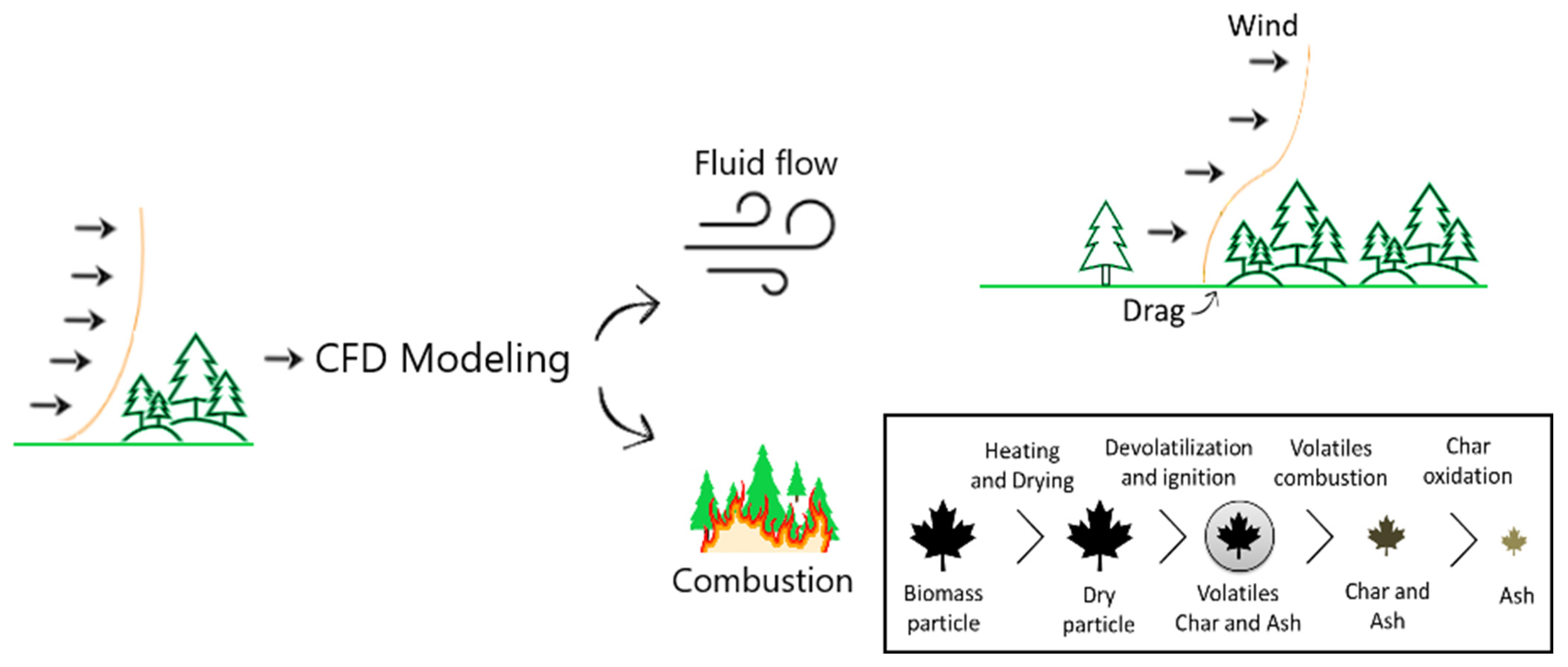
3.2.2. CFD Model
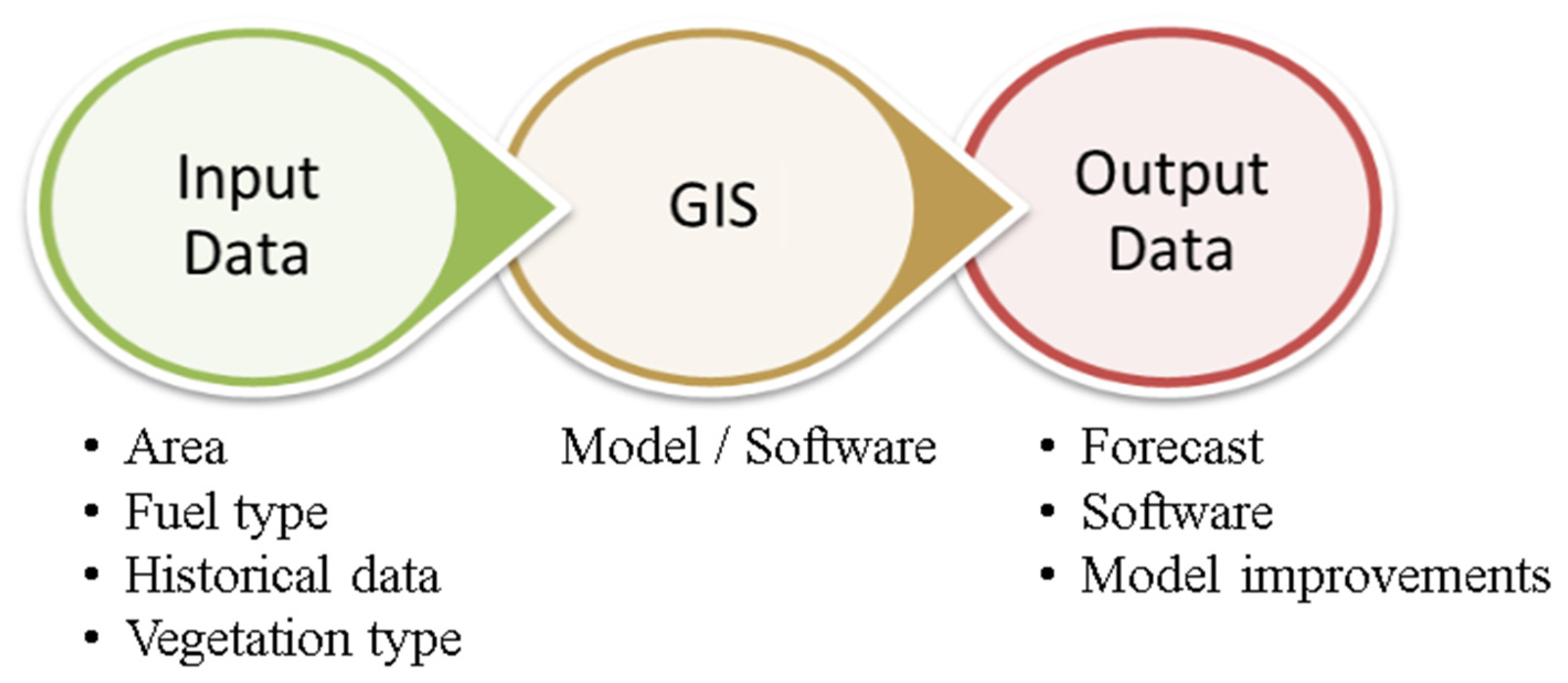
3.2.3. GIS Model
4. Research Topics Examined in the Selected Studies
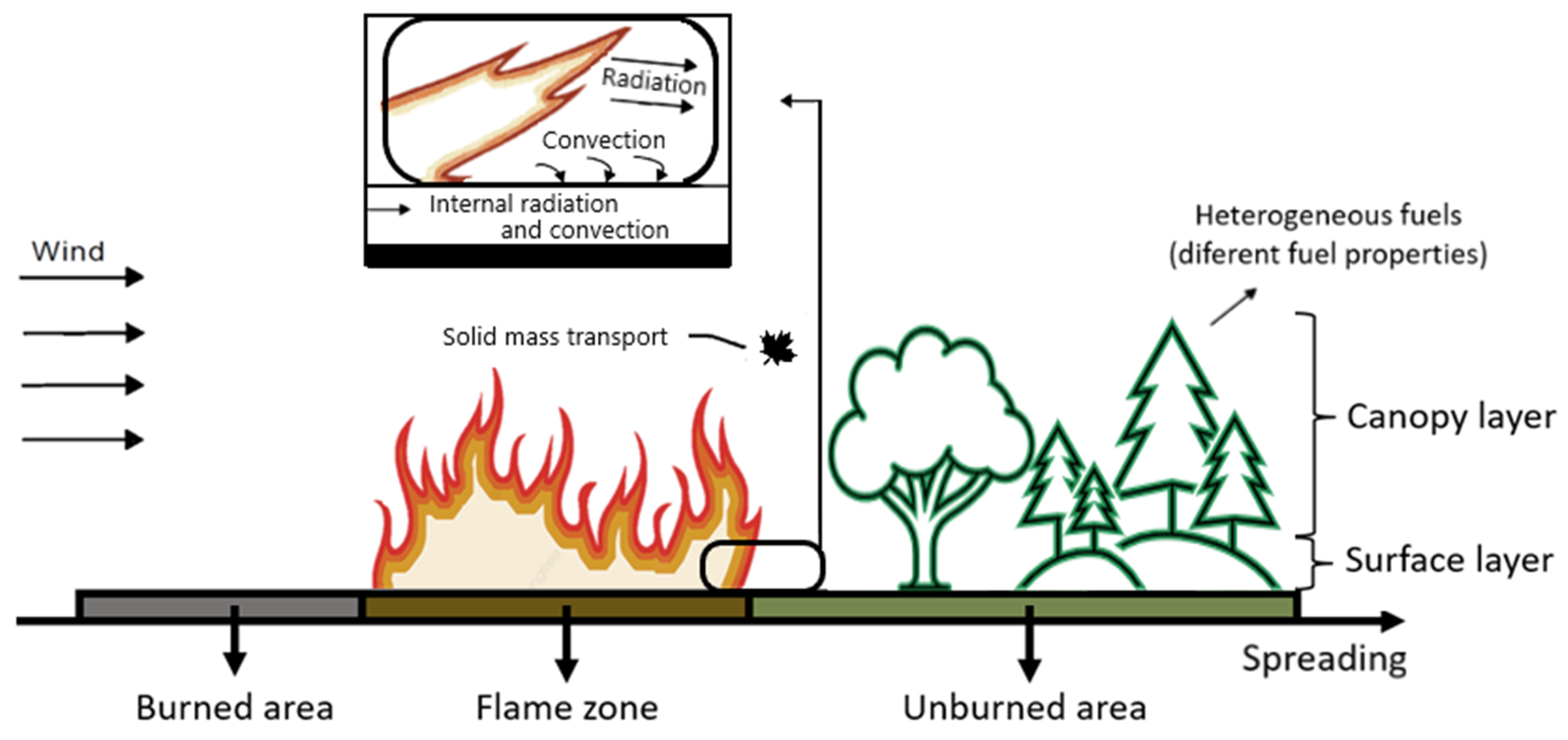
4.1. Air Flow
4.2. Vegetation
4.3. Combustion
5. Final Remarks
- A representative sample of wildfire modeling works and a reproducible investigation containing a representative number of relevant scientific papers were achieved. Nonetheless, some works not containing the exact keywords or the words not being contained in the databases are intentionally not included. The sample was considered representative of the current state-of-the-art of the main topic and comprehensive enough.
- Research over the past two decades has grown significantly and enhanced the mechanisms of wildfire and the primary influence of different parameters such as weather, topography, and fuel in the fire rate of spread. These advances improved the efficacy of wildfire predictions and the understanding of the phenomenon. Nevertheless, there is still consensus on the physical interpretation of the acceleration of wildfires, but complete knowledge of the mechanisms leading to its ignition and propagation are far from fully understood. Most of the works applied empirical models such as the Rothermel model, which only applies to situations where the environment and vegetative conditions are identical to those used for the study.
- Additionally, some CFD models developed for wildland fire studies require evaluation against relevant and equivalent experimental data to the simulated scenario. For this reason, this is why, these models are still considered as research tools among the scientific community. These were the main limitations found during the review.
- Sophisticated CFD models are still time consuming, even if executed on parallel supercomputers, and they need improvements regarding the interconnection between the fluid flow prediction and the vegetation consumption and combustion [56].
- Due to the fast development of technology and advances in computational power, GIS models seem to be effective for wildfire modeling tools due to the spatial nature of the fire spread and the easy integration of submodels, such as fire and wind models, and the ease of acquiring data and displaying the outputs.
- GIS models are being developed to provide near real-time predictive fire behavior modeling, making these tools useful for the different people involved in fire management, control, and suppression. Consequently, a model that is simple, intuitive, user-friendly, and accessible to a wide range of operators that might not be familiar with the different models is provided.
Author Contributions
Funding
Acknowledgments
Conflicts of Interest
Nomenclature
| CAWFE | Coupled Atmosphere–Wildland Fire-Environment |
| CFD | Computational Fluid Dynamic |
| EDC | Eddy Dissipation Concept |
| FDS | Fire Dynamics Simulator |
| FIRE | Fire code |
| GIS | Geographic Information System |
| GWR | Geographically Weight Regression |
| HDWM | High-Definition Wind Model |
| LES | Large Eddy Simulation |
| MDPI | Multidisciplinary Digital Publishing Institute |
| PhFFS | Physical Forest Fire Spread |
| RANS | Reynolds averaged Navier-Stokes |
| ROS | Fire Rate of Spread |
| WFDS | Wildland–urban interface Fire Dynamics Simulator |
| WRF | Weather Research and Forecasting model |
References
- Liu, N.; Lei, J.; Gao, W.; Chen, H.; Xie, X. Combustion dynamics of large-scale wildfires. Proc. Combust. Inst. 2021, 38, 157–198. [Google Scholar] [CrossRef]
- Sullivan, A.L. Inside the Inferno: Fundamental Processes of Wildland Fire Behaviour Part 1: Combustion Chemistry and Heat Release. Fire Sci. Manag. 2017, 3, 132–149. [Google Scholar] [CrossRef]
- Sullivan, A.L. Inside the Inferno: Fundamental Processes of Wildland Fire Behaviour Part 2: Heat Transfer and Interactions. Fire Sci. Manag. 2017, 3, 150–171. [Google Scholar] [CrossRef]
- Sullivan, A. Wildland surface fire spread modelling, 1990–2007. 1: Physical and quasi-physical models. Int. J. Wildland Fire 2009, 18, 349. [Google Scholar] [CrossRef]
- Sullivan, A.L. Wildland surface fire spread modelling, 1990–2007. 2: Empirical and quasi-empirical models. Int. J. Wildland Fire 2009, 18, 369. [Google Scholar] [CrossRef]
- Sullivan, A. Wildland surface fire spread modelling, 1990–2007. 3: Simulation and mathematical analogue models. Int. J. Wildland Fire 2009, 18, 387. [Google Scholar] [CrossRef]
- Bakhshaii, A.; Johnson, E.A. A review of a new generation of wildfire–atmosphere modeling. Can. J. For. Res. 2019, 49, 565–574. [Google Scholar] [CrossRef]
- Linn, R. A Transport Model for Prediction of Wildfire Behavior; Los Alamos National Lab.: Los Alamos, NM, USA, 1997. [Google Scholar]
- Linn, R.; Cunningham, P. Numerical simulations of grass fires using a coupled atmosphere-fire model: Basic fire behavior and dependence on wind speed. J. Geophys. Res. Atmos. 2005, 110, 1–19. [Google Scholar] [CrossRef]
- Reisner, J.; Bossert, J.; Winterkamp, J. Numerical Simulations of Two Wildfire Events Using a Combined Modeling System (HIGRAD/BEHAVE); No. LA-UR-97-4036; CONF-980121; Los Alamos National Lab.: Los Alamos, NM, USA, 1998. [Google Scholar]
- Reisner, J.; Wynne, S.; Margolin, L.; Linn, R. Coupled atmospheric-fire modeling employing the method of averages. Mon. Weather Rev. 2000, 128, 3683–3691. [Google Scholar] [CrossRef]
- Reisner, J.; Knoll, D.; Mousseau, V.; Linn, R. New numerical approaches for coupled atmosphere-fire models. In Proceedings of the Third Symposium on Fire and Forest Meteorology, 9 January 2000. [Google Scholar]
- Rothermel, R. A Mathematical Model for Predicting Fire Spread in Wildland Fuels; U.S. Department of Agriculture, Intermountain Forest and Range Experiment Station: Ogden, UT, USA, 1972; p. 40. [Google Scholar]
- Tolhurst, K.; Shields, B.; Chong, D. Phoenix: Development and Application of a Bushfire Risk Management Tool. Aust. J. Emerg. Manag. 2008, 23, 47–54. [Google Scholar]
- Tymstra, C.; Bryce, R.W.; Wotton, B.M.; Taylor, S.W.; Armitage, O.B. Development and Structure of Prometheus: The Canadian Wildland Fire Growth Simulation Model; Natural Resources Canada: Edmonton, AL, Canada, 2010. [Google Scholar]
- Johnston, P.; Kelso, J.; Milne, G. Efficient simulation of wildfire spread on an irregular grid. Int. J. Wildland Fire 2008, 17, 614. [Google Scholar] [CrossRef]
- Finney, M. FARSITE: Fire Area Simulator-Model Development and Evaluation; U.S. Department of Agriculture, Forest Service, Rocky Mountain Research Station: Ogden, UT, USA, 1998. [Google Scholar]
- Lopes, A.M.G.; Cruz, M.G.; Viegas, D.X. FireStation—An integrated software system for the numerical simulation of fire spread on complex topography. Environ. Model. Softw. 2002, 17, 269–285. [Google Scholar] [CrossRef]
- Vasconcelos, M.; Guertin, P. FIREMAP-Simulation of Fire Growth With a Geographic Information System. Int. J. Wildland Fire 1992, 2, 87. [Google Scholar] [CrossRef]
- Page, M.J.; McKenzie, J.E.; Bossuyt, P.M.; Boutron, I.; Hoffmann, T.C.; Mulrow, C.D.; Shamseer, L.; Tetzlaff, J.M.; Akl, E.A.; Brennan, S.E.; et al. The PRISMA 2020 statement: An updated guideline for reporting systematic reviews. Int. J. Surg. 2021, 88, 105906. [Google Scholar] [CrossRef]
- Mochida, A.; Tabata, Y.; Iwata, T.; Yoshino, H. Examining tree canopy models for CFD prediction of wind environment at pedestrian level. J. Wind Eng. Ind. Aerodyn. 2008, 96, 1667–1677. [Google Scholar] [CrossRef]
- Mandel, J.; Beezley, J.; Kochanski, A. Coupled atmosphere-wildland fire modeling with WRF 3.3 and SFIRE 2011. Geosci. Model Dev. 2011, 4, 591–610. [Google Scholar] [CrossRef]
- Ryan, K.; Opperman, T. LANDFIRE-A national vegetation/fuels data base for use in fuels treatment, restoration, and suppression planning. For. Ecol. Manag. 2013, 294, 208–216. [Google Scholar] [CrossRef]
- Pastor, E.; Zárate, L.; Planas, E.; Arnaldos, J. Mathematical models and calculation systems for the study of wildland fire behaviour. Prog. Energy Combust. Sci. 2003, 29, 139–153. [Google Scholar] [CrossRef]
- André, J.; Viegas, D. Modelos de Propagação de Fogos Florestais: Estado-da-Arte para Utilizadores Parte II: Modelos Globais e Sistemas Informáticos. Silva Lusit. 2002, 9, 237–265. [Google Scholar]
- Allaire, F.; Mallet, V.; Filippi, J.B. Novel method for a posteriori uncertainty quantification in wildland fire spread simulation. Appl. Math. Model. 2021, 90, 527–546. [Google Scholar] [CrossRef]
- Aedo, S.; Bonilla, C. A numerical model for linking soil organic matter decay and wildfire severity. Ecol. Modell. 2021, 447, 109506. [Google Scholar] [CrossRef]
- Jiang, W.; Wang, F.; Fang, L.; Zheng, X.; Qiao, X.; Li, Z.; Meng, Q. Modelling of wildland-urban interface fire spread with the heterogeneous cellular automata model. Environ. Model. Softw. 2021, 135, 104895. [Google Scholar] [CrossRef]
- Allaire, F.; Filippi, J.; Mallet, V. Generation and evaluation of an ensemble of wildland fire simulations. Int. J. Wildland Fire 2020, 29, 160–173. [Google Scholar] [CrossRef]
- Yuan, X.; Liu, N.; Xie, X.; Viegas, D. Physical model of wildland fire spread: Parametric uncertainty analysis. Combust. Flame 2020, 217, 285–293. [Google Scholar] [CrossRef]
- Rossa, C.; Fernandes, P. Empirical modeling of fire spread rate in no-wind and no-slope conditions. For. Sci. 2018, 64, 358–370. [Google Scholar] [CrossRef]
- Rossa, C.; Fernandes, P. An empirical model for the effect of wind on fire spread rate. Fire 2018, 1, 31. [Google Scholar] [CrossRef]
- de Gennaro, M.; Billaud, Y.; Pizzo, Y.; Garivait, S.; Loraud, J.; El Hajj, M.; Porterie, B. Real-time wildland fire spread modeling using tabulated flame properties. Fire Saf. J. 2017, 91, 872–881. [Google Scholar] [CrossRef]
- Hilton, J.; Miller, C.; Sullivan, A.; Rucinski, C. Effects of spatial and temporal variation in environmental conditions on simulation of wildfire spread. Environ. Model. Softw. 2015, 67, 118–127. [Google Scholar] [CrossRef]
- Simeoni, A.; Santoni, P.; Balbi, J. A strategy to elaborate forest fire spread models for management tools including a computer time-saving algorithm. Int. J. Model. Simul. 2002, 22, 213–224. [Google Scholar] [CrossRef][Green Version]
- Rochoux, M.; Delmotte, B.; Cuenot, B.; Ricci, S.; Trouvé, A. Regional-scale simulations of wildland fire spread informed by real-time flame front observations. Proc. Combust. Inst. 2013, 34, 2641–2647. [Google Scholar] [CrossRef]
- Simeoni, A.; Salinesi, P.; Morandini, F. Physical modelling of forest fire spreading through heterogeneous fuel beds. Int. J. Wildland Fire 2011, 20, 625–632. [Google Scholar] [CrossRef]
- Mallet, V.; Keyes, D.; Fendell, F. Modeling wildland fire propagation with level set methods. Comput. Math. Appl. 2009, 57, 1089–1101. [Google Scholar] [CrossRef]
- Morandini, F.; Simeoni, A.; Santoni, P.; Balbi, J. A model for the spread of fire across a fuel bed incorporating the effects of wind and slope. Combust. Sci. Technol. 2005, 177, 1381–1418. [Google Scholar] [CrossRef]
- Simeoni, A.; Santoni, P.; Larini, M.; Balbi, J. On the wind advection influence on the fire spread across a fuel bed: Modelling by a semi-physical approach and testing with experiments. Fire Saf. J. 2001, 36, 491–513. [Google Scholar] [CrossRef]
- Simeoni, A.; Santoni, P.; Larini, M.; Balbi, J. Proposal for theoretical improvement of semi-physical forest fire spread models thanks to a multiphase approach: Application to a fire spread model across a fuel bed. Combust. Sci. Technol. 2001, 162, 59–83. [Google Scholar] [CrossRef]
- Blocken, B. Computational Fluid Dynamics for urban physics: Importance, scales, possibilities, limitations and ten tips and tricks towards accurate and reliable simulations. Build. Environ. 2015, 91, 219–245. [Google Scholar] [CrossRef]
- Linn, R.; Goodrick, S.; Brambilla, S.; Brown, M.; Middleton, R.; O’Brien, J.; Hiers, J. QUIC-fire: A fast-running simulation tool for prescribed fire planning. Environ. Model. Softw. 2020, 125, 104616. [Google Scholar] [CrossRef]
- Buccolieri, R.; Santiago, J.L.; Rivas, E.; Sanchez, B. Review on urban tree modelling in CFD simulations: Aerodynamic, deposition and thermal effects. Urban For. Urban Green. 2018, 31, 212–220. [Google Scholar] [CrossRef]
- Lopes, A.; Ribeiro, L.; Viegas, D.; Raposo, J. Effect of two-way coupling on the calculation of forest fire spread: Model development. Int. J. Wildland Fire 2017, 26, 829–843. [Google Scholar] [CrossRef]
- Pimont, F.; Dupuy, J.; Linn, R. Coupled slope and wind effects on fire spread with influences of fire size: A numerical study using FIRETEC. Int. J. Wildland Fire 2012, 21, 828–842. [Google Scholar] [CrossRef]
- Linn, R.; Winterkamp, J.; Weise, D.; Edminster, C. A numerical study of slope and fuel structure effects on coupled wildfire behaviour. Int. J. Wildland Fire 2010, 19, 179–201. [Google Scholar] [CrossRef]
- Agranat, V.; Perminov, V. Mathematical modeling of wildland fire initiation and spread. Environ. Model. Softw. 2020, 125, 104640. [Google Scholar] [CrossRef]
- Canfield, J.; Linn, R.; Sauer, J.; Finney, M.; Forthofer, J. A numerical investigation of the interplay between fireline length, geometry, and rate of spread. Agric. For. Meteorol. 2014, 189–190, 48–59. [Google Scholar] [CrossRef]
- Zhang, K.; Verma, S.; Trouvé, A.; Lamorlette, A. A study of the canopy effect on fire regime transition using an objectively defined Byram convective number. Fire Saf. J. 2020, 112, 102950. [Google Scholar] [CrossRef]
- Frangieh, N.; Accary, G.; Morvan, D.; Méradji, S.; Bessonov, O. Wildfires front dynamics: 3D structures and intensity at small and large scales. Combust. Flame 2020, 211, 54–67. [Google Scholar] [CrossRef]
- Lopes, A.; Ribeiro, L.; Viegas, D.; Raposo, J. Simulation of forest fire spread using a two-way coupling algorithm and its application to a real wildfire. J. Wind Eng. Ind. Aerodyn. 2019, 193, 103967. [Google Scholar] [CrossRef]
- Frangieh, N.; Morvan, D.; Meradji, S.; Accary, G.; Bessonov, O. Numerical simulation of grassland fires behavior using an implicit physical multiphase model. Fire Saf. J. 2018, 102, 37–47. [Google Scholar] [CrossRef]
- Valero, M.; Jofre, L.; Torres, R. Multifidelity prediction in wildfire spread simulation: Modeling, uncertainty quantification and sensitivity analysis. Environ. Model. Softw. 2021, 141, 105050. [Google Scholar] [CrossRef]
- Linn, R.; Anderson, K.; Winterkamp, J.; Brooks, A.; Wotton, M.; Dupuy, J.; Pimont, F.; Edminster, C. Incorporating field wind data into FIRETEC simulations of the International Crown Fire Modeling Experiment (ICFME): Preliminary lessons learned. Can. J. For. Res. 2012, 42, 879–898. [Google Scholar] [CrossRef]
- Mueller, E.; Skowronski, N.; Clark, K.; Gallagher, M.; Mell, W.; Simeoni, A.; Hadden, R. Detailed physical modeling of wildland fire dynamics at field scale-An experimentally informed evaluation. Fire Saf. J. 2021, 120, 103051. [Google Scholar] [CrossRef]
- Zhang, K.; Lamorlette, A. An extensive numerical study of the burning dynamics of wildland fuel using proposed configuration space. Int. J. Heat Mass Transf. 2020, 160, 120174. [Google Scholar] [CrossRef]
- Atchley, A.; Linn, R.; Jonko, A.; Hoffman, C.; Hyman, J.; Pimont, F.; Sieg, C.; Middleton, R. Effects of fuel spatial distribution on wildland fire behaviour. Int. J. Wildland Fire 2021, 30, 179–189. [Google Scholar] [CrossRef]
- Chen, T.; Yuen, A.; Wang, C.; Yeoh, G.; Timchenko, V.; Cheung, S.; Chan, Q.; Yang, W. Predicting the fire spread rate of a sloped pine needle board utilizing pyrolysis modelling with detailed gas-phase combustion. Int. J. Heat Mass Transf. 2018, 125, 310–322. [Google Scholar] [CrossRef]
- Desmond, C.; Watson, S.; Hancock, P. Modelling the wind energy resources in complex terrain and atmospheres. Numerical simulation and wind tunnel investigation of non-neutral forest canopy flows. J. Wind Eng. Ind. Aerodyn. 2017, 166, 48–60. [Google Scholar] [CrossRef]
- Houssami, M.; Thomas, J.; Lamorlette, A.; Morvan, D.; Chaos, M.; Hadden, R.; Simeoni, A. Experimental and numerical studies characterizing the burning dynamics of wildland fuels. Combust. Flame 2016, 168, 113–126. [Google Scholar] [CrossRef]
- Hoffman, C.; Mell, W.; Sieg, C.; Pimont, F. Evaluating Crown Fire Rate of Spread Predictions from Physics-Based Models. Fire Technol. 2016, 52, 221–237. [Google Scholar] [CrossRef]
- Satoh, K.; Liu, N.; Zhou, K.; Xie, X. CFD study of termination of fire whirls in urban fires. Procedia Eng. 2013, 62, 1040–1049. [Google Scholar] [CrossRef]
- Linn, R.; Sieg, C.; Hoffman, C.; Winterkamp, J.; McMillin, J. Modeling wind fields and fire propagation following bark beetle outbreaks in spatially-heterogeneous pinyon-juniper woodland fuel complexes. Agric. For. Meteorol. 2013, 173, 139–153. [Google Scholar] [CrossRef]
- Koo, E.; Linn, R.; Pagni, P.; Edminster, C. Modelling firebrand transport in wildfires using HIGRAD/FIRETEC. Int. J. Wildland Fire 2012, 21, 396–417. [Google Scholar] [CrossRef]
- Ghisu, T.; Arca, B.; Pellizzaro, G.; Duce, P. An application of the level-set method to fire front propagation. In Proceedings of the International Conference on Fire Behaviour and Risk, Alghero, Italy, 4–6 October 2011; pp. 227–228. [Google Scholar]
- Dupuy, J.; Linn, R.; Konovalov, V.; Pimont, F.; Vega, J. Exploring three-dimensional coupled fireatmosphere interactions downwind of wind-driven surface fires and their influence on backfires using the HIGRAD-FIRETEC model. Int. J. Wildland Fire 2011, 20, 734–750. [Google Scholar] [CrossRef]
- Parsons, R.; Sauer, J.; Linn, R. Crown Fuel Spatial Variability and Predictability of Fire Spread. In Proceedings of the VI International Conference on Forest Fire Research, Coimbra, Portugal, 15–18 November 2010. [Google Scholar]
- Endalew, A.; Hertog, M.; Gebrehiwot, G.; Baelmans, M.; Ramon, H.; Nicolaï, B.; Verboven, P. Modelling airflow within model plant canopies using an integrated approach. Comput. Electron. Agric. 2009, 66, 9–24. [Google Scholar] [CrossRef]
- Linn, R.; Winterkamp, J.; Colman, J.; Edminster, C.; Bailey, J. Modeling interactions between fire and atmosphere in discrete element fuel beds. Int. J. Wildland Fire 2005, 14, 37–48. [Google Scholar] [CrossRef]
- Crawl, D.; Block, J.; Lin, K.; Altintas, I. Firemap: A Dynamic Data-Driven Predictive Wildfire Firemap: Data-Driven Predictive Firemap: A Dynamic Dynamic Data-Driven Environment Predictive Wildfire Wildfire Modeling and Visualization Firemap: Dynamic Predictive Wildfire Modeling a. Procedia Comput. Sci. 2017, 108, 2230–2239. [Google Scholar] [CrossRef]
- Oliveira, U.; Soares-Filho, B.; Costa, W.; Gomes, L.; Bustamante, M.; Miranda, H. Modeling fuel loads dynamics and fire spread probability in the Brazilian Cerrado. For. Ecol. Manag. 2021, 482, 118889. [Google Scholar] [CrossRef]
- Salis, M.; Arca, B.; Del Giudice, L.; Palaiologou, P.; Alcasena-Urdiroz, F.; Ager, A.; Fiori, M.; Pellizzaro, G.; Scarpa, C.; Schirru, M.; et al. Application of simulation modeling for wildfire exposure and transmission assessment in Sardinia, Italy. Int. J. Disaster Risk Reduct. 2021, 58, 102189. [Google Scholar] [CrossRef]
- Valero, M.; Rios, O.; Mata, C.; Pastor, E.; Planas, E. An integrated approach for tactical monitoring and data-driven spread forecasting of wildfires. Fire Saf. J. 2017, 91, 835–844. [Google Scholar] [CrossRef]
- Monedero, S.; Ramirez, J.; Molina-Terrén, D.; Cardil, A. Simulating wildfires backwards in time from the final fire perimeter in point-functional fire models. Environ. Model. Softw. 2017, 92, 163–168. [Google Scholar] [CrossRef]
- Herráez, P.; Sevilla, A.; Canals, F.; Cascón, M.; Rodríguez, M. A GIS-based fire spread simulator integrating a simplified physical wildland fire model and a wind field model. Int. J. Geogr. Inf. Sci. 2017, 31, 2142–2163. [Google Scholar] [CrossRef]
- Duane, A.; Aquilué, N.; Gil-Tena, A.; Brotons, L. Integrating fire spread patterns in fire modelling at landscape scale. Environ. Model. Softw. 2016, 86, 219–231. [Google Scholar] [CrossRef]
- Finney, M.A. Fire growth using minimum travel time methods. Can. J. For. Res. 2002, 32, 1420–1424. [Google Scholar] [CrossRef]
- Makridis, A. Modelling of Wind Turbine Wakes in Complex Terrain Using Computational Fluid Dynamics. Master’s Thesis, University of Edinburgh, Edinburgh, UK, 2012. [Google Scholar]
- Cedell, P. Forest Simulation with Industrial CFD Codes; KTH Royal Institute of Technology: Stockholm, Sweden, 2019. [Google Scholar]
- Urbanski, S.P.; Hao, W.M.; Baker, S. Chapter 4 Chemical Composition of Wildland Fire Emissions. Dev. Environ. Sci. 2008, 8, 79–107. [Google Scholar]


| Author and Year | Citations | Type of Model | Key Aspects | Main Conclusions |
|---|---|---|---|---|
| Linn et al., 2005 [9] | 118 | CFD | Investigation of fire behavior aspects in grasslands. | ROS depends on ambient wind and shape and size of the fire. |
| Lopes et al., 2002 [18] | 100 | CFD/GIS | Implementation of a semi-empirical model to compute the ROS. | Realistic simulations of wildfire growth for planning fire suppression. |
| Mochidaa et al., 2008 [21] | 89 | CFD | Optimization of model coefficients for reproducing the effect of trees. | Successful testing of different models in comparison to field measurements. |
| Mandel et al., 2011 [22] | 70 | Math | Description of the physical model, numerical algorithms, and software structure. | The model was able to support real runs, considering the level-set method. |
| Kevin et al., 2013 [23] | 62 | GIS | The origin and the use of LANDFIRE are outlined. | LANDFIRE provides the means to design cost-effective fuel treatment alternatives. |
| Author | Software/Model | Type of Fuel | Terrain Configuration | Wind Velocity (m/s) | Outputs |
|---|---|---|---|---|---|
| Allaire et al., 2021 [26] | ForeFire/Rothermel | Grass and Sclerophyllous | - | - | Burned area |
| Aedo and Bonilla 2021 [27] | - | Soil organic matter | - | - | Temperature profiles |
| Jiang et al., 2021 [28] | FlamMap6 | - | Forest area | 0–15 | ROS |
| Allaire et al., 2020 [29] | Rothermel | - | - | 0.66–1.5 | ROS |
| Yuan et al., 2020 [30] | - | Heterogeneous vegetation | Different slopes (from 0° to 32°) | - | ROS |
| Rossa and Fernandes 2018 [31] | Rothermel | Litter, grass, branches and slash | Flat terrain | Windless conditions | ROS |
| Rossa and Fernandes 2018 [32] | Rothermel | Acacia, Pinus, and Eucalyptus | Flat terrain | 0.4–3.13 | ROS |
| Matthieu et al., 2017 [33] | SWIFFT | Forest fuel | Upslope, downslope and flat terrains | Australia: 4.83 Thailand: 0.75 Corsica: 6 | ROS and burned area |
| Hilton et al., 2015 [34] | CSIRO Grassland Fire Spread Model | Grass | - | 7.5 | ROS and fire perimeter shape |
| Simeoni et al., 2015 [35] | - | Pine needles | Different slopes (from 0° to 30°) | 0–3 | ROS and fire perimeter |
| Rochoux et al., 2013 [36] | Rothermel | Grass | Flat terrains | 1.3 | Fire front positions |
| Simeoni et al., 2011 [37] | Morandini | Pine needles | Flat terrain | Windless conditions | ROS |
| Mallet et al., 2009 [38] | - | Burned and unburned vegetation | - | - | Fire front evolution |
| Johnston et al., 2008 [16] | FARSITE | Forest fuel | Mount Cooke in Australia | 8.33 | ROS |
| Morandini et al., 2005 [39] | - | Pine needles | Different slopes (0° and 15°) | −3–3 | ROS and heat flux |
| Simeoni et al., 2001 [40] | Larini | Pine needles | Different slopes (0° and 15°) | −3–3 | ROS and gas velocity |
| Simeoni et al., 2001 [41] | Larini | Pine needles | Different slopes (0° and 15°) | −3–3 | ROS and gas velocity |
| Author | Air Temperature (°C) | Relative Humidity (%) | Fuel Particle Density (kg/m3) | Fuel Load (kg/m2) | Surface- Volume Ratio (m−1) | Fuel Moisture Content (%) |
|---|---|---|---|---|---|---|
| Aedo and Bonilla 2021 [27] | 30 | - | 1200 | - | - | - |
| Allaire et al., 2020 [29] | - | - | 512 | 0.02–0.9 | 2460–7218 | - |
| Rossa and Fernandes 2018 [31] | 9.5–36.9 | 17–82 | 255–790 | 0.39–3.5 | 4470–15,360 | 2.2–161.7 |
| Rossa and Fernandes 2018 [32] | 14.8–30 | 20–81 | 398–510 | 0.1–3.6 | 630–7596 | 2.7–28.2 |
| Matthieu et al., 2017 [33] | 30–40 | - | 500 and 720 | 0.294 and 2.682 | 13,600 and 15,360 | - |
| Simeoni et al., 2015 [35] | - | - | 680 | 0.4 | 4550 | 1–3 |
| Rochoux et al., 2013 [36] | - | - | - | - | 4921 | - |
| Simeoni et al., 2011 [37] | - | - | - | 0.5 | - | 10 |
| Johnston et al., 2008 [16] | 35 | 20 | - | - | - | 3 |
| Morandini et al., 2005 [39] | 28 | - | 680 | 0.5 | 4550 | 9–11 |
| Simeoni et al., 2001 [41] | - | - | - | 0.5 | - | 9–11 |
| Author | Scale | Software/ Model | Turbulence | Combustion Mechanism | Turbulence-Chemistry Interaction | Vegetation | Initial Conditions |
|---|---|---|---|---|---|---|---|
| Valero et al., 2021 [54] | Medium | WFDS | LES | ✔ | - | ✔ | - |
| Mueller et al., 2021 [56] | Medium | WFDS | Deardorff | ✔ | ✔ | ✔ | Velocity profile |
| Atchley et al., 2021 [58] | Medium | FIRETEC | LES | - | - | ✔ | Velocity and turbulence profiles |
| Zhang and Lamorlette 2020 [57] | Small | ForestFireFoam | LES | ✔ | ✔ | ✔ | Velocity profile |
| Zhang et al., 2020 [50] | Small | ForestFireFoam | LES | ✔ | ✔ | ✔ | Velocity profile |
| Linn et al., 2020 [43] | Medium and Large | QUIC-Fire | - | ✔ | - | ✔ | Velocity profile |
| Agranat and Perminov, 2020 [48] | Small | PHOENICS | RNG | ✔ | ✔ | ✔ | Velocity profile Turbulent intensity Ignition source |
| Frangieh et al., 2020 [51] | Small and Large | FireStar3D | RNG and LES | ✔ | ✔ | ✔ | Velocity profile |
| Lopes et al., 2019 [52] | Large | FireStation | k-ε | - | - | ✔ | Velocity profile |
| Frangieh et al., 2018 [53] | Medium | FireStar3D | RNG | ✔ | ✔ | ✔ | Velocity profile |
| Chen et al., 2018 [59] | Small | - | LES | ✔ | ✔ | ✔ | - |
| Desmond et al., 2017 [60] | Small | Ansys CFX | SST | - | - | ✔ | Velocity and turbulence profiles |
| Lopes et al., 2017 [45] | Large | FireStation | k-ε | - | - | ✔ | Velocity profile |
| Houssami et al., 2016 [61] | Small | FireFOAM | LES | ✔ | ✔ | ✔ | - |
| Hoffman et al., 2015 [62] | - | FIRETEC and WFDS | LES | ✔ | ✔ | ✔ | - |
| Canfield et al., 2014 [49] | Medium | HIGRAD/ FIRETEC | LES | - | - | ✔ | Velocity profile |
| Satoh et al., 2013 [63] | Medium | NIST FDS-4 | - | - | - | ✔ | Velocity profile |
| Linn et al., 2013 [64] | Medium | HIGRAD/ FIRETEC | - | - | - | ✔ | Velocity profile |
| Pimont et al., 2012 [46] | Medium | HIGRAD/ FIRETEC | LES | - | - | ✔ | Fire widths Velocity profile |
| Linn et al., 2012 [55] | Medium | FIRETEC | - | ✔ | - | ✔ | Velocity profile |
| Koo et al., 2012 [65] | Medium | HIGRAD/ FIRETEC | - | ✔ | - | ✔ | Firelines length |
| Ghisu et al., 2011 [66] | Large | Ansys Fluent | RNG | - | - | - | Fire propagation |
| Mandel et al., 2011 [22] | Large | WRF-SFIRE | LES | - | - | - | Velocity profile and Level set function |
| Dupuy et al., 2011 [67] | Medium | HIGRAD/ FIRETEC | LES | ✔ | - | ✔ | Velocity profile |
| Parsons et al., 2010 [68] | Medium | HIGRAD/ FIRETEC | - | - | - | ✔ | Velocity profile |
| Linn et al., 2010 [47] | Medium | HIGRAD/ FIRETEC | - | - | - | ✔ | Velocity profile |
| Endalew et al., 2009 [69] | Small | Ansys CFX | k-ε | - | - | ✔ | Velocity and turbulence profiles |
| Mochida et al., 2008 [21] | Small | - | k-ε | - | - | ✔ | Velocity profile |
| Linn et al., 2005 [9] | Medium | HIGRAD/ FIRETEC | - | ✔ | - | ✔ | Velocity profile and fireline |
| Linn and Cunningham, 2005 [70] | Medium | HIGRAD/ FIRETEC | - | ✔ | - | ✔ | Ignition source Velocity profile |
| Lopes et al., 2002 [18] | Large | FireStation | k-ε | - | - | - | Velocity |
| Reisner et al., 2000 [11] | Medium | HIGRAD/ FIRETEC | NA | ✔ | ✔ | ✔ | - |
| Reisner et al., 1998 [10] | Large | HIGRAD/ BEHAVE | - | - | - | ✔ | Temperature, density, and velocity |
| Author | Scale | Software/ Model | Vegetation | Weather | Outputs | ||
|---|---|---|---|---|---|---|---|
| Height | Moisture | Fuel | |||||
| Oliveira et al., 2021 [72] | Landscape | GWR | - | ✔ | ✔ | Very dry | Fire spread probability |
| Salis et al., 2021 [73] | 24,000 km2 | FConstMTT [78] | ✔ | ✔ | ✔ | 7–30 °C Wind: W, NW | Wildfire exposure and risk. |
| Crawl et al., 2017 [71] | Landscape | Firemap | - | - | ✔ | NA | Fire spread prediction |
| Valero et al., 2017 [74] | 300 m × 300 m | Aerial imaging system and Rothermel | - | ✔ | ✔ | NA | Fire map and its forecast |
| Monedero et al., 2017 [75] | 1400 ha | Different algorithms | - | ✔ | ✔ | 30 °C 23 km/h S | Fire perimeter |
| Herráez et al., 2016 [76] | 3315 m × 2740 m | ArcGIS with PhFFS and HDWM | ✔ | ✔ | ✔ | 30 to 32 °C; 3.18 to 8 m/s | Fire perimeter and front position |
| Duane et al., 2016 [77] | 32,107 km2 | Medspread | ✔ | ✔ | ✔ | NA | Fire perimeter |
| Ryan et al., 2013 [23] | NA | LANDFIRE | ✔ | ✔ | ✔ | NA | - |
| Vasconcelos et al., 1992 [19] | Landscape | FIREMAP | ✔ | ✔ | ✔ | Wind: S | ROS, fireline intensity, and area burned |
Publisher’s Note: MDPI stays neutral with regard to jurisdictional claims in published maps and institutional affiliations. |
© 2022 by the authors. Licensee MDPI, Basel, Switzerland. This article is an open access article distributed under the terms and conditions of the Creative Commons Attribution (CC BY) license (https://creativecommons.org/licenses/by/4.0/).
Share and Cite
Silva, J.; Marques, J.; Gonçalves, I.; Brito, R.; Teixeira, S.; Teixeira, J.; Alvelos, F. A Systematic Review and Bibliometric Analysis of Wildland Fire Behavior Modeling. Fluids 2022, 7, 374. https://doi.org/10.3390/fluids7120374
Silva J, Marques J, Gonçalves I, Brito R, Teixeira S, Teixeira J, Alvelos F. A Systematic Review and Bibliometric Analysis of Wildland Fire Behavior Modeling. Fluids. 2022; 7(12):374. https://doi.org/10.3390/fluids7120374
Chicago/Turabian StyleSilva, João, João Marques, Inês Gonçalves, Rui Brito, Senhorinha Teixeira, José Teixeira, and Filipe Alvelos. 2022. "A Systematic Review and Bibliometric Analysis of Wildland Fire Behavior Modeling" Fluids 7, no. 12: 374. https://doi.org/10.3390/fluids7120374
APA StyleSilva, J., Marques, J., Gonçalves, I., Brito, R., Teixeira, S., Teixeira, J., & Alvelos, F. (2022). A Systematic Review and Bibliometric Analysis of Wildland Fire Behavior Modeling. Fluids, 7(12), 374. https://doi.org/10.3390/fluids7120374