1. Introduction
Climate change is transforming hydrological regimes worldwide, posing particularly severe risks in water-stressed areas [
1,
2]. Arid and semi-arid zones (which constitute nearly 40% of the Earth’s surface and are home to over 2 billion people) are increasingly susceptible to declining precipitation, rising temperatures, and intensifying land degradation [
3]. These areas experience synergies among multiple stress factors. They are subjected, among others, to accelerated soil erosion, salinization, and unsustainable land-use practices that reduce water security, agricultural production, the functioning of terrestrial ecosystems, and the operational lifespan of hydraulic infrastructure systems for capturing and storing limited water resources [
4,
5]. In consequence, it has become crucial to understand the complex interactions among climate variability, land degradation, and water systems in order to strengthen the resilience of dryland socio-ecological systems.
These global dynamics are well reflected in the Saharan Atlas region of Algeria, a transitional area between the Mediterranean Tell Atlas and the hyper-arid Sahara [
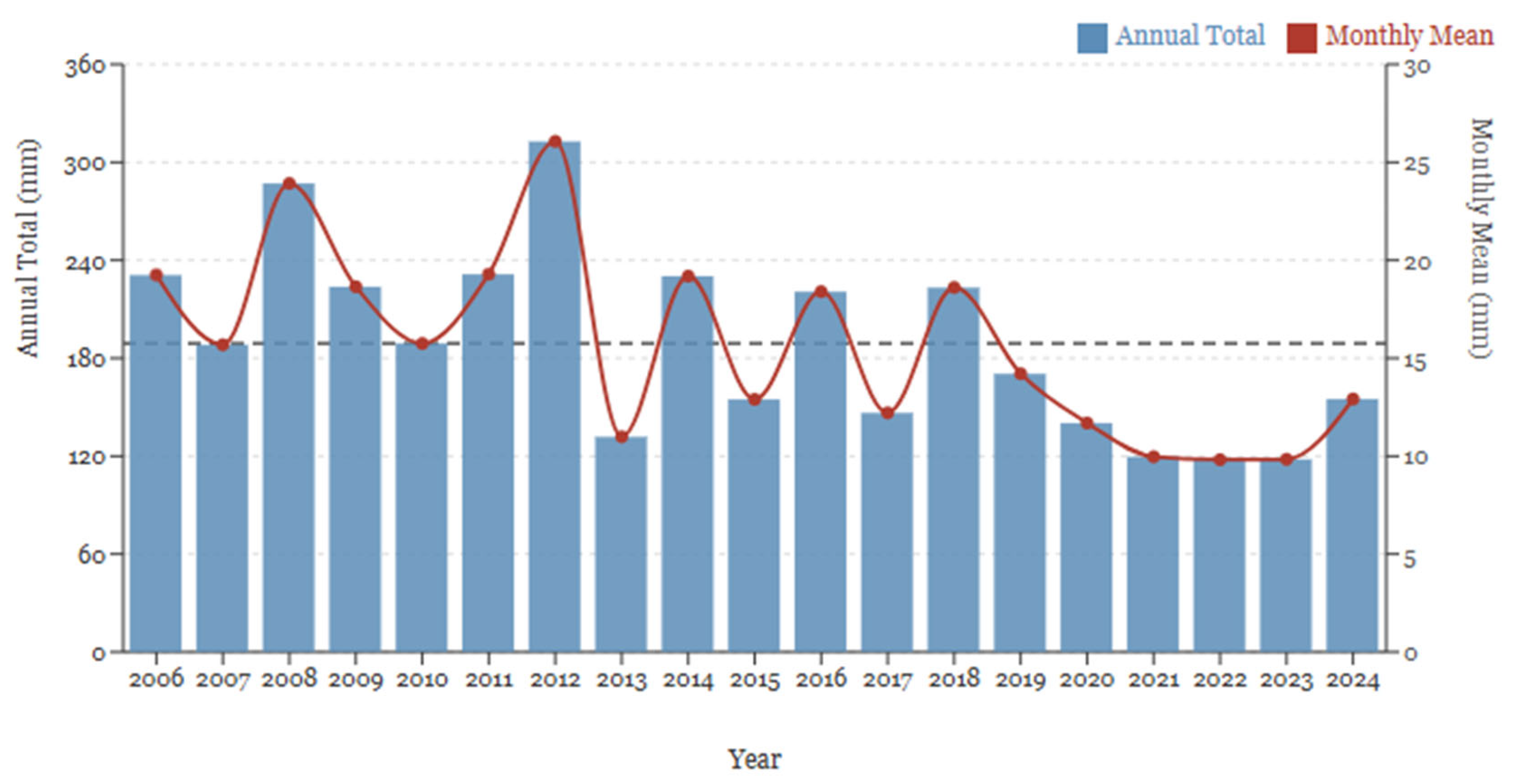
6]. Rainfall decreases of 20–40% have occurred in western and central Algeria over the last century, alongside temperature increases of 1.5–2.0 °C during the past five decades [
7,
8]. Such climatic changes have impacted groundwater recharge, vegetation cover, agricultural yields, and the year-round operation of dams and reservoirs, which form the basis of Algeria’s water mobilization strategy [
9]. Diminished precipitation and elevated evapotranspiration have engendered increased hydrological variability, while extreme rainfall events have heightened surface runoff and sediment transport [
10,
11].
Algeria currently has over 80 large dams, with a theoretical storage capacity of more than 9 billion cubic meters [
12]. But accelerated upstream soil erosion results in sedimentation at a rate estimated to collectively yield an annual loss of about 45 million cubic meters of storage capacity [
13]. In high-altitude catchments with rugged, highly eroding topography within the Saharan Atlas, including Naama Province, sediment yields have been recorded in excess of 1000 t km
2 yr, one of the highest values measured throughout North Africa [
14]. The accumulation of sediment at rapid rates diminishes the efficiency of water storage in reservoirs, degrades the quality of the water held, and increases operational costs, while drastically reducing the longevity of infrastructure [
14,
15,
16]. Thus, sustainable hydrology in these systems should involve integrated watershed management practices that consider both erosion processes and the dynamics of water quality [
17,
18].
In arid and semi-arid regions where water management is vital, this paper is focused on small-to-medium-sized hill reservoirs that offer supplementary services, including irrigation, livestock watering, groundwater recharge facilitation, and flood alleviation [
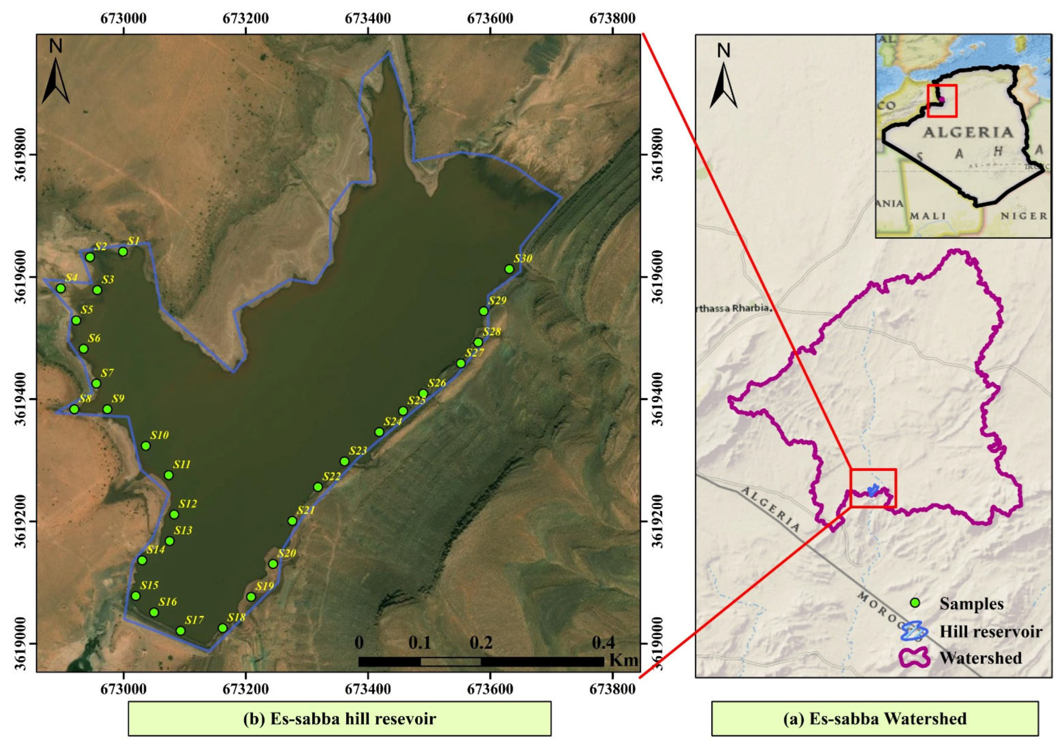
19]. Designed to irrigate about 150 hectares and contribute to improved rural water security, the Es-Sabba hill Reservoir was built in the early 2000s, outside of the village of Sfissifa in Naama Province. However, similar to other comparable structures in the Saharan Atlas, its long-term sustainability is under threat from rapid siltation associated with upstream land degradation and vigorous erosive processes. Sustainable management of such systems requires a spatially explicit understanding of erosion hotspots, sediment delivery pathways, and water quality conditions.
Geospatial technologies and remote sensing have been endorsed recently for watershed assessment in data-scarce contexts [
20,
21,
22]. GIS-integrated satellite imagery and empirical erosion models allow for quantitative risk mapping of erosion events, identification of selective sediment source areas, and evaluation of potential scenarios for conservation [
23]. Preparedness of such tools is often the domain of integrated land management scales, where the RUSLE has been among the most commonly applied models for estimating watershed-scale long-term average soil loss because of its conceptual framework and relatively moderate data needs [
24,
25,
26]. RUSLE, coupled with high-resolution satellite data and digital elevation models (DEMs), contributes to a fine-scale understanding of topographic controls, vegetation cover, and land-use patterns that mediate erosion dynamics [
27]. In semi-arid North Africa, increases in the salinity and turbidity of reservoirs due to evaporation and sediment resuspension have been reported. However, water can still be suitable for irrigation with targeted management [
28].
Another important aspect of sustainable watershed management is soil fertility [
29]. Low organic matter, nitrogen deficiency, phosphorus fixation, and alkaline pH of arid calcareous soils limit vegetation growth [
30]. Low fertility leads to reduced plant cover, which increases soil exposure and susceptibility to erosion and creates a degradation feedback loop [
31]. Composite indices (such as soil nutrient index (SNI) and soil fertility index (SFI)) combine several parameters, including pH, organic matter, nitrogen, phosphorus, potassium, and cation exchange capacity, into spatially meaningful indicators that enable targeted management interventions [
32]. Indeed, circular-economy methodologies designed around the application of nutrient-rich reservoir sediments as soil amendments demonstrate potent solutions for improving fertility and elongating reservoir longevity.
By now, a growing recognition has developed of the multi-dimensional nature of watershed degradation in arid environments, but virtually all studies still tend to treat erosion, water quality, and soil fertility as independent entities [
33]. So far, only a handful of studies have addressed high-resolution remote sensing combined with GIS-based RUSLE modeling, hydrochemical assessment, and soil fertility analysis within a unified analytical framework accounting for small hill reservoirs in Algeria [
34,
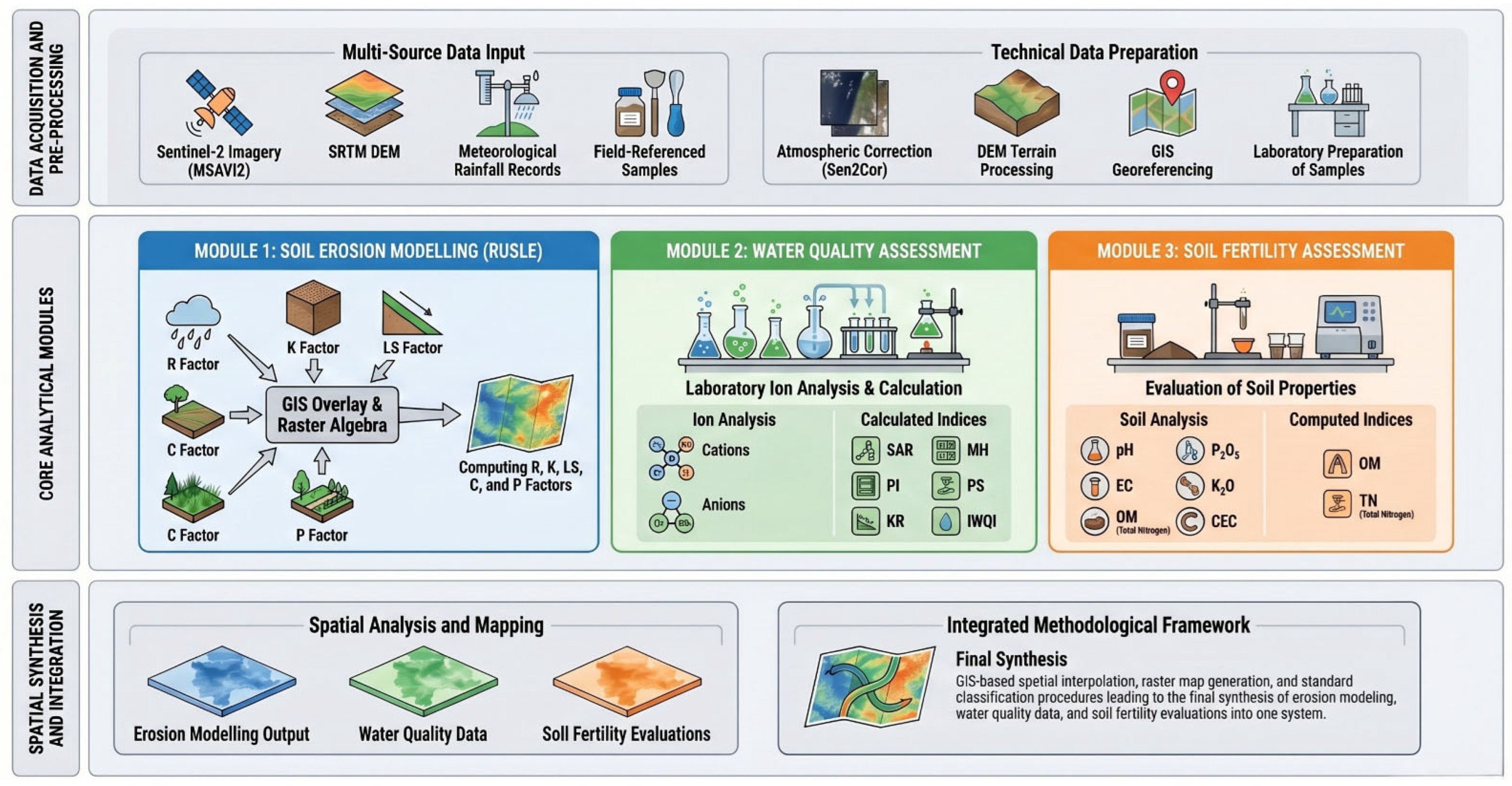
35]. The Es-Sabba watershed has not been previously studied, and no comprehensive assessments of its erosion dynamics, sediment yield (SY), water quality, or soil fertility status have been conducted. This knowledge gap limits the ability to make evidence-based decisions regarding conservation planning and climate adaptation in Naama Province. The novelty of this study lies in its integration of three components: RUSLE-based erosion modeling, hydrochemical water quality assessment, and composite soil fertility indexing within a single spatially explicit framework applied to a previously unstudied arid hill reservoir catchment in the Saharan Atlas. Unlike prior studies that address these dimensions independently, this unified approach enables the identification of synergistic management opportunities, particularly the circular-economy reuse of trapped sediments as soil amendments. Therefore, this study determines a multi-criteria geospatial analysis of the Es-Sabba hill reservoir watershed. The specific objectives are: (1) to quantify the spatial patterns and magnitude of soil erosion using revised universal soil loss equation (RUSLE) integrated with Sentinel-2 multispectral imagery and GIS-based terrain attributes; (2) to assess quality of irrigation water through physicochemical characterization and suitability indices; (3) to evaluate plant nutrient status in soils by leveraging composite nutrient indices for identifying limitations toward vegetation-based soil erosion control; and, (4) to identify and evaluate evidence-based integrated watershed management strategies capable of measurably improving reservoir lifespan, irrigation water sustainability, and soil fertility in climate-vulnerable arid catchments. The integration of erosion modeling, hydrochemical evaluation, and soil fertility assessment into a common sustainability framework represents a methodological advancement for data-limited dryland watersheds over both the Saharan Atlas range and the larger Mediterranean–Saharan transition zone.
3. Results
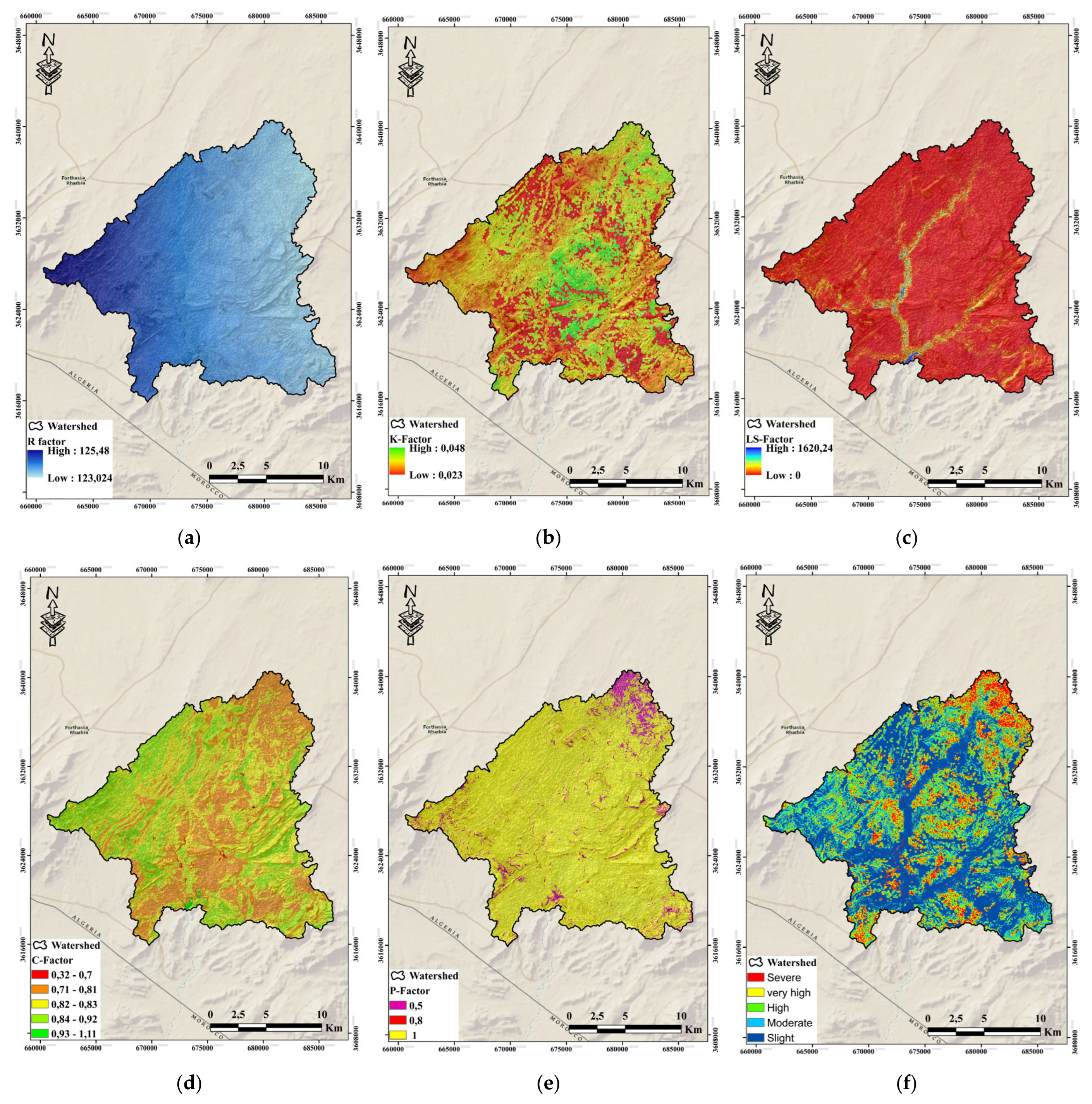
Individual RUSLE factors showed a similar expected spatial pattern across the watershed consistent with physiographic and land-use characteristics.
The rainfall erosivity factor (R) demonstrated a southwest-to-northeast gradient, with the lowest values (123 MJ/mm/ha/h/yr) and the highest ones (125 MJ/mm/ha/h/yr) occurring at high altitudes and in elevated southern locations correlating with orographic precipitation enhancement activity and localized convective storm activity (
Figure 4a). As can be seen in (
Figure 4b), variation in soil texture significantly contributed to the patchy distribution of soil erodibility factor (K), which had high values (0.048 t/ha/h/ha/MJ/mm) for silty-clay valley soils and low values (0.023 t/ha/h/ha/MJ/mm) for coarse sandy upland regions, respectively. The variability for the topographic factor (LS) (
Figure 4c) was highest in terms of spatial dispersion, ranging from completely flat alluvial areas with low values and terrestrial escarpments with slope gradients over 35%, well above a value of 1600. LS was most spatially similar to the topography of high values distributed along incised wadi channels, badland areas, and in the northwestern ridge system, where slope length and gradient are maximized. Cover management factor (C) exhibited a spatial mosaic of vulnerability to erosion, as protected areas (C = 0.32) coexisted with dense shrubland in less reachable forms and high-susceptibility regions (C = 0.93–1.11), mostly coinciding with degraded rangeland and barren surfaces (
Figure 4d). A spatially distributed support practice factor (P) was mapped across the entire watershed. Values of P approaching 1.0 were recorded in areas where field surveys confirmed the absence of any active soil conservation measures (
Figure 4e). Low
p values (0.5–0.8) were assigned in rare agricultural areas where contour farming or small-scale mechanical conservation interventions are practiced.
3.1. Soil Erosion Hazard Classification
The five RUSLE factors were combined to produce an annual soil loss map (
Figure 4f) with values ranging from 40 t/ha/yr on steep sparsely vegetated slopes. The area distribution showed that classification into severity categories was revealed as detailed in the following (
Table 4).
Soil degradation is widespread, as demonstrated by the fact that ~68.4% of the watershed area is affected by high-to-severe erosion rates (>20 t/ha/yr). Severe erosion (>40 t/ha/yr) is observed on 16.2% of the watershed and is localized in three active zones: (1) northwestern steep-slope badlands developed on Jurassic marls; (2) incised wadi channels with actively eroding banks and less than a quarter of riparian humid vegetation; and (3) over-stressed rangeland on moderate slopes (15–25%) with >50% ground cover as Bare Soil.
Spatial pattern of erosion hazard is in good agreement with the LS-factor, indicating that topography governs spatial variability of erosion throughout the Es-Sabba watershed. The C-factor secondary correlation shows that land cover change through restoration of vegetative cover or better grazing management could substantially decrease erosion rates, particularly in moderate-to-high eroding sectors with more relaxed topographic controls.
3.2. Sediment Yield Estimation
The average annual soil loss at the scale of the whole watershed was calculated to be 26.3 t/ha/yr, which corresponds to a total sediment production of 386,610 tons per year within the watershed. However, less sediment eroded from land is delivered to the reservoir due to deposition in footslopes and wadi channels and on individual alluvial fans. Using a sediment delivery ratio (SDR) of 0.35, which is characteristic for semi-arid watersheds of this size, gives an estimated annual sediment delivery to Es-Sabba reservoir of about 135,300 tons/yr. The projected functional lifespan of 11–15 years was derived as follows: assuming a reservoir total storage capacity of approximately 3.0 mm3 and a bulk sediment density of 1.3 t/m3, the annual volume loss is 104,077 m3/yr, equivalent to ~3.5% of total capacity per year. The time to reach 50% capacity loss (the common threshold for functional impairment) is therefore approximately 14 years. This finding is consistent with observations from comparable Tunisian and Moroccan hill reservoirs. Regarding the agronomic potential of trapped sediment: based on measured soil TN of 0.08% and organic matter of 1.51%, the 135,300 t/yr of deposited sediment carries an estimated nitrogen load of approximately 108 t/yr and an organic matter contribution of ~2043 t/yr, suggesting meaningful soil amendment value if dredged and redistributed to adjacent degraded agricultural land.
3.3. Water Quality and Soil Fertility Assessment
Physicochemical Characteristics
The physicochemical properties of all samples collected from the Es-sabba ranged widely (
Table 5) and were consistent with semi-arid inland waters that are susceptible to evaporative concentration and geology dominated by carbonates. This means the site was alkaline, and the electrical conductivity (240 to 268 µS cm mean = 258 ± 12 µS cm) indicates that water belongs within the fresh, low salinity range; total dissolved solids were 124 to 163 mg/L (mean = 138 ±16 mg/L) lower than World Health Organization drinking water guideline of 400 mg/L and still reflect seasonal and case-day thermal stratification with temperature ranging from 18.4 to 23.9 °C (mean = 21.1° C).
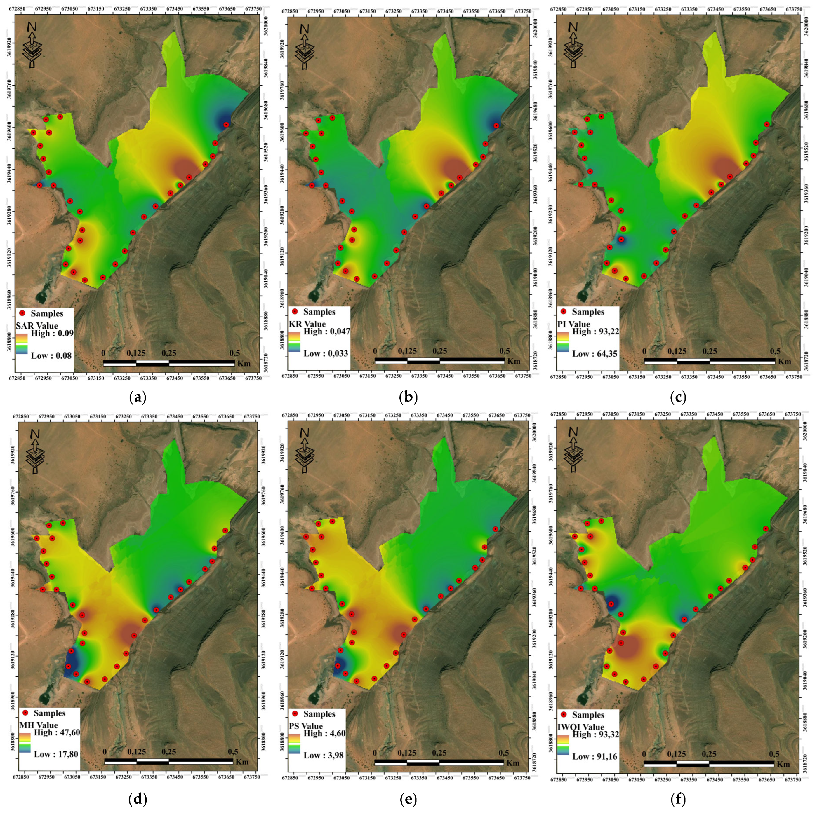
In general, all analyzed indicators of irrigation quality suggest a highly acceptable hydrochemical regime for agricultural purposes in the studied hill reservoir system. Sodium adsorption ratio (SAR) ranged from 0.0805 to 0.0980, with an average of 0.0851 ± 0.0043, which shows very low sodicity hazard and the absence of greater sodium-induced soil dispersion risk (
Figure 5a). Kelly’s ratio (KR) revealed a moderately varying trend, as it varied between 0.0328 and 0.0470 in the samples (mean = 0.0348 ± 0.0032), still below the critical threshold of 1.0, which agreed with the significant prevalence of divalent cations (Ca
2+ and Mg
2+) to Na
+ (
Figure 5b). The permeability index (PI) ranged from 64.33 to 93.24, with a mean value calculated as equal to 71.03 ±6.88, piling most of the readings under class I or II range, implying that these influence soil permeability stability over time and infiltration rate stability as well (
Figure 5c). The Magnesium Hazard (MH), indicating risk of magnesium dependently affecting alkalinity and structural deterioration, ranged from 17.78 to 47.61% (mean = 34.89 ± 7.01), always below the critical limit of the threshold value of magnesium, which, together with alkalinity, can affect structural deterioration risk occurring in ~10% samples (<2 dS m) (
Figure 5d). Moderate salinity potential (PS) values, such as a PS of 3.98 to approximately 4.61 (>mean = 4.34 ± 0.18), denote a city chloride–sulfate salinity load that is considerable in this respect, but does not serve as an overtly controlling factor in situations of adequate drainage (
Figure 5e). This is due to the occasional salt accumulation in some poorly drained micro sites. The composite Irrigation Water Quality Index (IWQI) displayed remarkable uniformity, varying only between 91.16 and 92.33 with a mean of 91.75 ± 0.28, classifying all samples as excellent for irrigation use (
Figure 5f). However, evaluation against FAO irrigation water quality guidelines indicated that Es-Sabba reservoir water is suitable for agricultural use with moderate restrictions. Under high evaporation conditions, sulfate concentrations tend to increase due to evapoconcentration, which may elevate the SO
42− load above values measured during wetter periods. Sustained high sulfate concentrations could pose risks to irrigation infrastructure through scaling and pipe clogging, and this seasonal fluctuation should be monitored in future campaigns spanning both wet and dry seasons.
The content of organic matter was consistently low (average 1.51 ± 0.76%) due to limited biomass input, high rates of mineralization, and surface horizon depletion induced by erosion. Total nitrogen was observed to be 0.06 and 0.10% (mean 0.08 ± 0.04%), which indicates low nitrogen availability, confirming that nitrogen is one of the main limiting nutrients in this system [
33]. The available phosphorus (P
2O
5) was 37–48 ppm (mean: 42.5 ± 3.19 ppm). The availability of phosphorus does not seem to be as limiting as that observed in calcareous arid soils, with levels of phosphorus (≈ 18.7 mg/kg) being considered moderate to adequate for rainfed cereal production after conversion. Exchangeable potassium concentrations were high (mean K
2O = 223 ppm), which is in line with a significant supply of K from mineral weathering and low leaching intensity (
Table 6). Dominant soluble ions were chloride and sulfate, and sodium concentrations were moderate, suggesting a potential salinity but only very early signs of sodicity hazard.
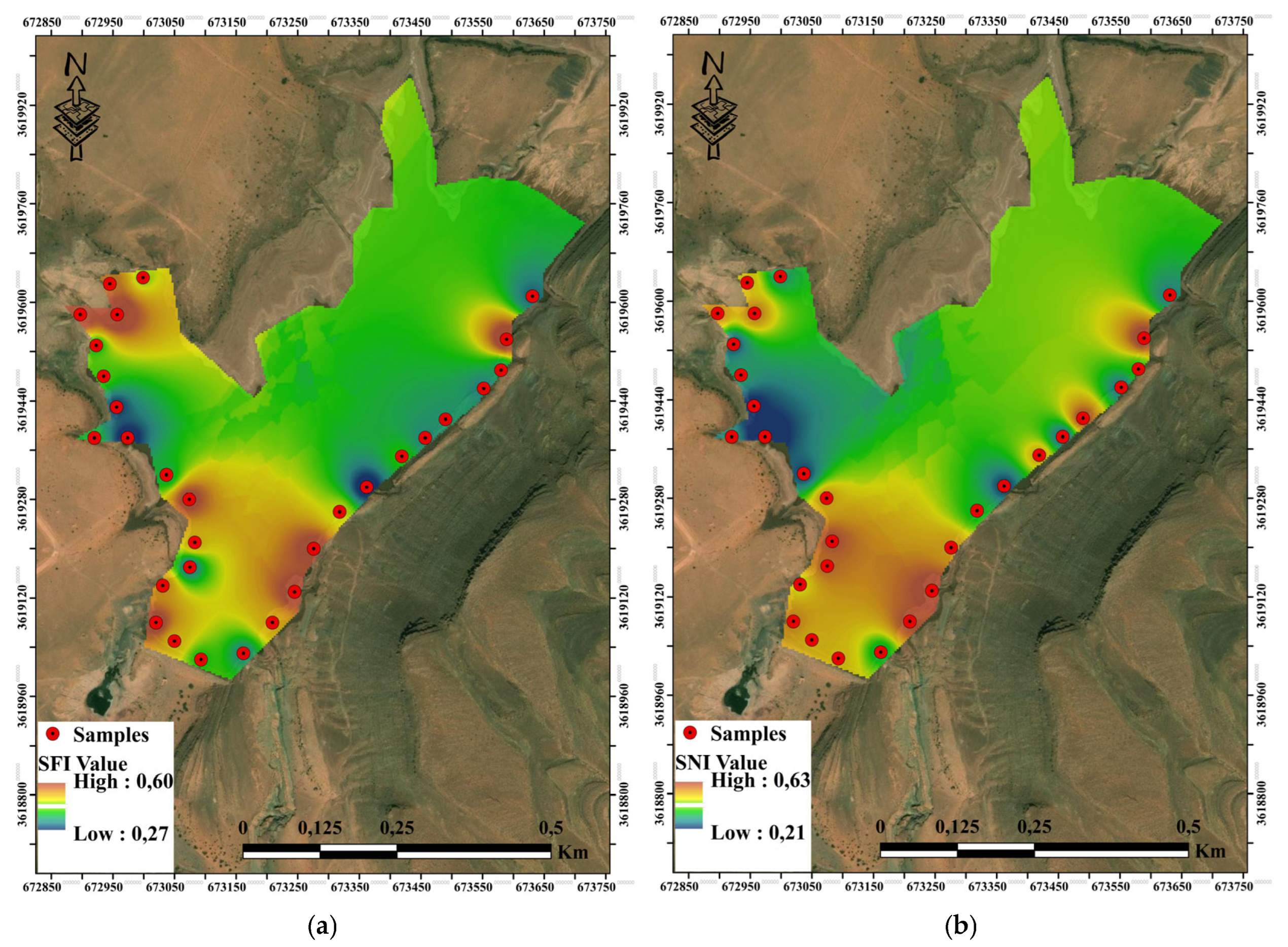
Figure 6 depicts moderate but spatially heterogeneous soil fertility conditions of 30 hill reservoir soil samples as derived from the soil fertility index (SFI) (
Figure 6a) and soil nutrient index (SNI) (
Figure 6b). Soil fertility index (SFI) values ranged from 0.267 to 0.597 and were between a mean value of 0.416 ± SD = 0.096, indicating that soil fertility overall belongs to the low-to-moderate class for most samples, except for some that tended towards a lower limit of soil fertility threshold (
Table 7). Thus, the coefficient of variation (≈23%) indicates moderate spatial variability in integrated fertility status, likely reflecting micro-topographic deposition patterns and localized variations in organic matter accumulation and nutrient retention.
Consequently, overall low-to-moderate fertility status with particular emphasis on the localized nutrient deficiencies formed the basis of indices pertaining to the studied soils as potential candidates for assessments adapted towards their sustainable productivity under calcareous arid system.
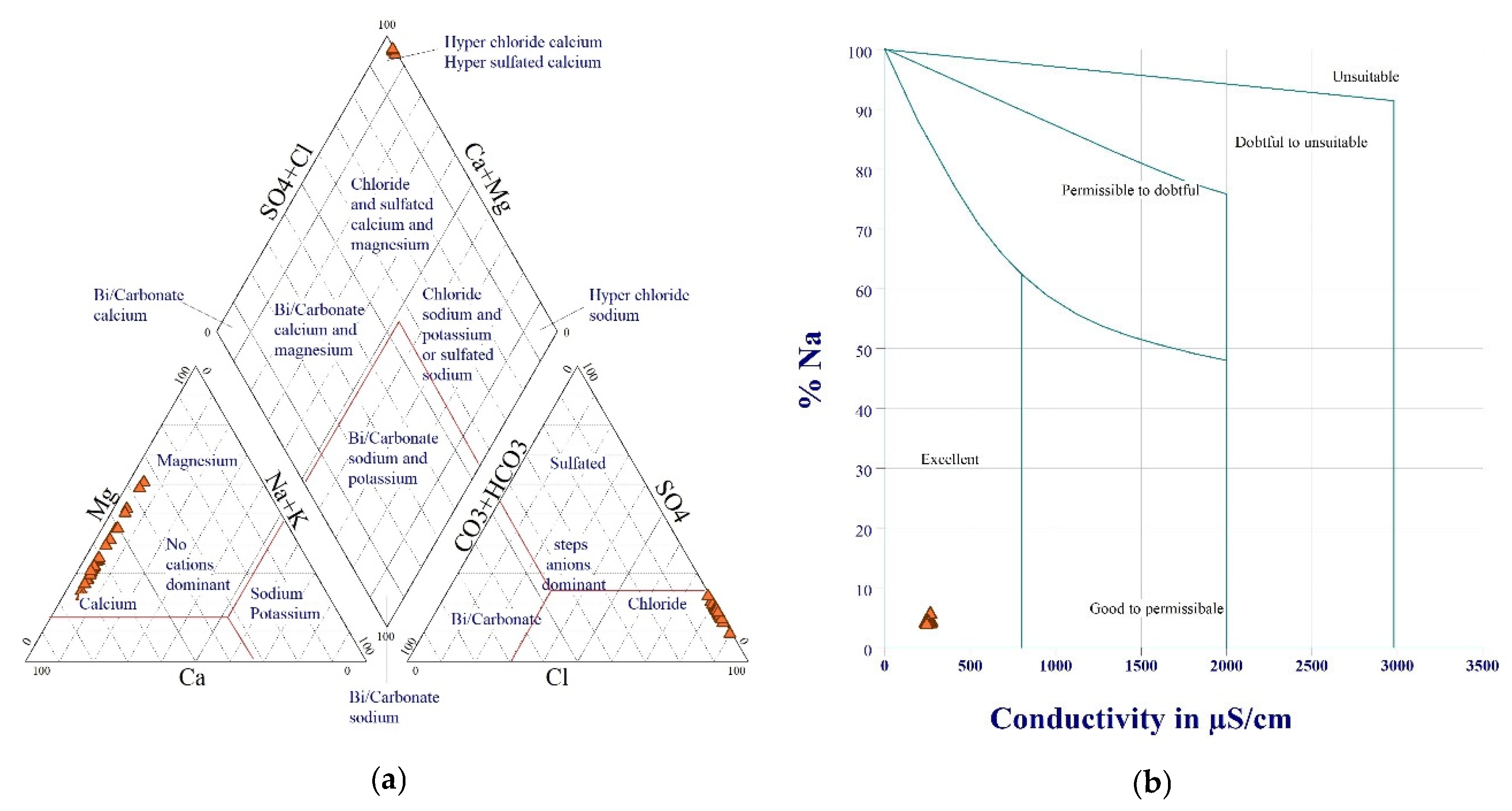
The Piper trilinear diagram (
Figure 7a) reveals that all Es-Sabba reservoir samples belong to the Ca–Mg–HCO
3 hydrochemical facies. In the cation triangle, samples cluster in the Ca
2+ dominant zone, with a secondary Mg
2+ contribution and negligible Na
+, reflecting the predominance of divalent cations derived from calcareous and dolomitic parent materials of the Ksour Mountains. In the anion triangle, HCO
3− is dominant, with SO
42− as a secondary contributor, and essentially negligible Cl
−. Projection onto the central diamond confirms a Bi/Carbonate calcium–magnesium water type, characteristic of waters that have equilibrated with carbonate mineral assemblages and undergone limited evaporitic enrichment. The dominance of HCO
3− and SO
42− is consistent with dissolution of calcite, dolomite, and minor gypsum–anhydrite intercalations in the Cretaceous sedimentary sequence. The Wilcox diagram (
Figure 7b) confirms the excellent irrigation suitability of all samples, which were placed in the low-salinity range. This graphical classification is fully consistent with the IWQI (mean 91.75) and SAR values (mean 0.085), providing independent visual corroboration of the reservoir water’s low sodicity and low salinity hazard for agricultural irrigation.
4. Discussion
The integrated geospatial assessment of the Es-Sabba watershed shows that a mean annual soil loss of 26.3 t/ha/yr is an order of magnitude greater than tolerable limits often quoted for semi-arid environments (2–5 t/ha/yr), confirming that erosion rates at these levels are unsustainable in the long-term given pressing demands for continuing to guarantee soil and water security in this arid Saharan Atlas system. This value does, however, lie within the range of values reported for other mountainous North African catchments characterized by steep slopes and erodible lithologies as well as degraded vegetation. Khodja et al. [
59] estimated 18.4 t/ha/yr in the Bou Rouina watershed, northeastern Algeria, using RUSLE–SDR coupling, whereas studies from the Moroccan Anti-Atlas typically range between 15 and 35 t/ha/yr [
60], according to land-use intensity and conservation status. The spatial concentration of severe erosion (16.2% of sediment >40 t/ha/yr) within a minor part of the Es-Sabba watershed supports the well-acknowledged “80/20” property of sediment delivery, which states that only a small fraction of hillslopes and channels is responsible for most sediment yield, and is consistent with regional-scale summaries from Mediterranean and North African basins highlighting topographically controlled badlands, gully systems, and rangelands overgrazed as preponderant areas where deposition occurs [
61,
62].
The high correlation of soil loss with the LS factor indicated that topography remained the primary control of erosion processes through the pasture throughout this extensive management watershed, as opposed to more intensively cultivated Mediterranean agro-systems, where factors related to crop and support practice (C,P) dominate spatial variability. Nonetheless, the important secondary role of cover management also suggests there is good potential for soil loss reduction through shrub cover restoration, conservational agricultural practices, and grazing pressure regulation, which supports European-scale and North African applications of RUSLE where large reductions in erosion are found once vegetation cover exceeds 40–50% of total soil area. From the perspective of reservoir management, an estimated sediment delivery of approximately 135,300 t/yr (specific siltation rate ~767 m
3/km
2/yr) ranks Es-Sabba among the most affected dams in Algeria with respect to reported national infrastructure figures ranging between 400 and 200,000 m
3/km
2/yr. The estimated 4.5% annual volume loss, and its reported useful lifespan of only between 11 and 15 years, also corroborates other observational findings based on Tunisian hill reservoirs, where over half of the existing structures have already lost more than half their capacity within two or three decades, and fast siltation is observed on Tunisian dams [
63]. These results directly inform sustainable development and water security targets. Rapid siltation compromises the ability of the Es-Sabba reservoir to provide irrigation, livestock watering, and flood attenuation services, thereby jeopardizing local progress toward SDG 2 (Zero Hunger) and SDG 6 (Clean Water and Sanitation). International and Algerian case studies provide evidence that watershed treatment, a combination of mechanical structures (check dams, contour bunds, and terraces) and biological measures (reforestation, rangeland restoration), can achieve reductions in sediment delivery of 30–50% within a decade while regenerating ecosystem services and rural livelihoods. It follows that, for Es-Sabba, the risk of top soil erosion hazard assessed to be severe or very high on hillslopes and channels accounting for a relatively small percentage of the total land area would still provide out-sized benefits to increased reservoir lifespan at an appropriate cost relative to any other potential use of sediment control infrastructure; this is consistent with cost–benefit analyses of measures taken in similar semi-arid basins.
The results show that this reservoir is a mixed type, with low sulfate and moderate salinity, making its potability limited while still allowing safe use for irrigation under adequate management and drainage conditions, as seen in other Algerian reservoirs like Koudiat Medouar and Babar [
64,
65]. Considering the low EC and SAR values of Es-Sabba water, it falls into the most favorable FAO classes for agricultural use; however, in hot, dry periods, this water should not be used to sprinkler-irrigate crops sensitive to sulfate because of the risk of leaf burn due to SO
42− and localized salt accumulation. The combination of the irrigation suitability advantage and block trend due to hill reservoirs for capturing up-slope rainfall signals a need to focus management on conserving this resource that supports agriculture, while investigating decentralized or blended supplies for drinking.
The hydrochemical facies revealed by the Piper diagram, the Ca–Mg–HCO
3 type, is consistent with findings from comparable semi-arid Algerian reservoirs, including Babar and Koudiat Medouar [
58,
59], where carbonate lithologies dominate catchment geology and evaporative concentration increases SO
42− relative to Cl
−. The absence of Na
+-Cl
− or Na
+-SO
42− facies confirms that halite dissolution and anthropogenic contamination are not significant processes in this watershed, which is important for long-term irrigation sustainability. The concentration of samples in a single facies field reflects the geochemical uniformity of the catchment, dominated by Jurassic–Cretaceous carbonates and evaporites, and suggests that intra-seasonal hydrochemical variability is controlled primarily by evapoconcentration rather than by shifts in water sources or flow paths [
58]. The Wilcox diagram independently corroborates the low sodicity risk: all samples in the Excellent class confirm that current irrigation practices with Es-Sabba water carry minimal risk of soil permeability degradation or Na
+-induced clay dispersion, provided that surface irrigation methods are used and periodic leaching fractions are applied to prevent bicarbonate and sulfate accumulation in the crop root zone.
Patterns of soil fertility characteristics in the watershed are a critical connecting tissue between land degradation and potential for ecosystem-based erosion control. A chronic phosphorus deficiency, a factor that limits nitrogen availability in calcareous arid soils [
66], and wide variances of very low total nitrogen across most samples are characteristic of this class of dryland regime (e.g., the denuded Ica Valley of Peru or North African steppe agro-systems) where multi-nutrient limitations lower biomass production rates and contribute to diminished protective vegetative cover. In Es-Sabba, this level of fertility constrains not just existing agricultural productivity but also limits the establishment of vegetative measures meant to stabilize soils and reduce runoff, forming a feedback loop between erosion, falling fertility, and continued loss of vegetation. Integrating nitrogen-fixing legumes, targeted P fertilization and organic amendments would increase yields and improve soil physical properties substantially compared to studies done in cereal zones of Algerian settings; such combinations that adapt to local socio-economic conditions were identified as key options for overcoming biological constraints in the context of conservation agriculture and rangeland restoration plots, and packages that take advantage of local resources unlock the full potential of these technologies in this watershed.
One of the major opportunities arising from this study is to use reservoir sediments as soil amendment, thus following the circular-economy approaches that are being increasingly promoted in semi-arid areas. The moderate fertility index values obtained from both sites, together with successful examples of use in Brazilian and other dryland reservoirs where dredged sediments have contributed nitrogen and phosphorus to crops, indicate that the reuse of sediment under appropriate management can generate simultaneous restoration of storage capacity while imposing complementary input on nutrients for prudent control of salinization risks as well as possible trace-metal accumulation. This viewpoint complements recent work on nutrient recycling and sediment valorization, linking local reservoir management to wider debates around sustainability that concern the efficiency of resource use and waste reduction in water-limited settings.
Despite the comprehensive nature of our multi-criteria framework, a number of limitations should be noted in relation to interpreting results and translating them into policy. First, RUSLE is a long-term average and not event-scale erosion dynamics; in extremely episodic climates, e.g., Saharan Atlas, many annual sediment yield numbers can be produced by only a few intense storms, so it would be better to couple with a process-based or event-driven hydrological and erosion model (e.g., WEPP or EUROSEM) in order to better represent peak loads of sediment and climate-change sensitivity.
Validation of the RUSLE-estimated erosion rates against measured suspended sediment data was not possible due to the absence of a stream gauge at the reservoir outlet; however, indirect corroboration is provided by comparison with a substantial body of regional literature, as discussed above. Beyond the Algerian and Moroccan comparisons already noted, Djoukbala et al. [
61] obtained mean specific erosion rates of 9.65–11.33 t/ha/yr across USLE, RUSLE, and MUSLE frameworks in the Wadi Gazouana watershed (NW Algeria); the lower values relative to Es-Sabba reflect that catchment’s gentler slopes and denser Mediterranean vegetation cover, while their multi-model comparison represents a methodological strength not adopted here, though RUSLE remains the most widely validated framework for data-scarce arid basins. In Tunisia, Serbaji et al. [
63] applied RUSLE with GIS and reported losses of 10–45 t/ha/yr in semi-arid basins of similar physiography, with the highest values concentrated in badland zones analogous to the northwestern sector of the Es-Sabba watershed. In the eastern Mediterranean, Hammad et al. [
62] calibrated RUSLE for Jordanian and Palestinian watersheds and reported values of 5–40 t/ha/yr under varying land-use intensities; their study is notable for incorporating field-measured runoff plots that allowed direct model validation, precisely the type of ground-truth approach that future bathymetric surveys of Es-Sabba reservoir would enable, providing site-specific siltation rates for robust model validation.
Second, the sediment delivery ratio used to scale hillslope erosion to reservoir siltation is based on the regional literature and not site-specific monitoring, which should be refined through bathymetric surveys followed by measurements of suspended sediment from runoff events. Third, water quality was measured from a single dry-season campaign and again lacked seasonal and interannual variation in turbidity, nutrients, and microbiological contamination despite evidence from other Algerian works, as well as for semi-arid equivalents, that substantial fluctuations can occur across wet and dry periods. The single dry-season water quality campaign is acknowledged as a significant limitation; conclusions about irrigation suitability should be treated as indicative rather than definitive, and future monitoring should encompass at least one wet-season sampling round to capture the full seasonal range of hydrochemical variability. Regarding laboratory QA/QC: all water and soil analyses were performed following standardized protocols (APHA 2017 for water; ISO 10390, ISO 14235 for soil). Reagent blanks, duplicate samples (10% of total), and certified reference standards were used throughout. The different sampling years (soil in July 2024, water in July 2025) reflect logistical constraints of field access; soil properties are relatively stable interannually under these arid conditions, and the temporal offset is not expected to introduce significant systematic bias. Fourth, soil fertility indicators were predominantly chemical parameters, and biological indicators of soil health and socio-economic dimensions of management adoption did not fall within the scope (although increasing recognition is given to these as paramount for designing effective and resilient interventions). Finally, the study screened current conditions and management options conceptually; it did not assess specific conservation measures on the ground, and thus, their effectiveness and cost-effectiveness in the Es-Sabba context need to be validated through pilot projects and long-term monitoring.
However, by providing a joint diagnosis of soil erosion, water quality, and soil fertility within one geospatial framework, this work propels the integrated diagnostic capacity on offer to date for data-sparse arid catchments and flags a transition from sectoral to system-level planning in Naama Province. The approach is in accordance with recent regional initiatives harnessing satellite remote sensing and empirical models, e.g., RUSLE and composite soil–water indices, to produce decision-support information that prioritizes interventions under climate uncertainty. The methodology, when adapted and scaled to other hill reservoirs in the Saharan Atlas and Mediterranean–Saharan transition zones, can support robust reservoir design, targeted watershed treatment, and climate-resilient agricultural development, thereby strengthening national strategies for water security, land restoration, and rural livelihood improvement.
5. Contribution to Sustainable Development Goals (SDGs)
The findings of this study contribute to several United Nations Sustainable Development Goals (SDGs) by addressing the interconnected challenges of soil erosion, reservoir sustainability, water quality, and soil fertility management in arid environments. These processes are closely interlinked and represent major constraints to sustainable land and water management, particularly in dryland regions such as North Africa and the Mediterranean basin.
In these environments, accelerated soil erosion and land degradation constitute fundamental threats to ecosystem stability and agricultural productivity. Processes such as water erosion, nutrient depletion, and soil salinization reduce soil functionality and compromise long-term sustainability. This directly relates to SDG 15 (Life on Land), especially in the context of achieving land degradation neutrality (LDN) [
67,
68]. The situation observed in the Es-Sabba watershed, where a large proportion of land is affected by severe erosion, highlights the urgent need for effective soil conservation strategies to restore ecosystem functions and prevent further degradation.
Addressing these challenges requires robust tools for monitoring and decision-making. In this context, the integration of geospatial technologies, remote sensing, and GIS-based models such as RUSLE provides a powerful framework for identifying erosion hotspots and prioritizing conservation actions at the watershed scale [
67,
69,
70]. Furthermore, erosion modeling combined with climate and land-use scenarios supports the development of sustainable land management strategies aligned with global sustainability targets [
71]. These approaches contribute not only to improved land management but also to climate adaptation strategies, thereby reinforcing links with SDG 13 (Climate Action) alongside SDG 15.
The implications of soil erosion extend beyond land degradation to directly affect water resources. Sustainable watershed management is therefore essential for maintaining water availability and reservoir functionality, which are central to SDG 6 (Clean Water and Sanitation). In arid regions, reservoirs and small dams play a critical role in water security; however, their effectiveness is increasingly compromised by sedimentation resulting from upstream erosion. Previous studies highlight that sediment transport, climate variability, and catchment degradation significantly influence reservoir performance and water availability [
72]. Controlling sediment inflow through integrated watershed management is thus crucial for preserving storage capacity and ensuring the long-term reliability of water supply systems.
At the same time, soil degradation has significant consequences for agricultural productivity and food security. The loss of fertile topsoil and declining soil quality directly reduces crop yields and threatens rural livelihoods. Sustainable land management practices implemented in dryland agro-ecosystems have demonstrated their capacity to improve soil fertility, enhance water use efficiency, and strengthen resilience [
73]. These outcomes directly support SDG 2 (Zero Hunger) by promoting more sustainable and productive agricultural systems.
Recent advances in agroecological practices further reinforce this perspective. Techniques such as agroforestry, conservation tillage, mulching, and crop diversification contribute to reducing erosion while improving soil structure, organic matter content, and water retention [
74,
75]. When integrated within a watershed management framework, these practices generate multiple environmental and socio-economic benefits, enhancing the resilience of agricultural systems under increasing climatic stress.
In addition, sustainable land management can contribute to broader resource efficiency through circular approaches. For instance, the reuse of reservoir sediments as soil amendments offers a dual benefit by restoring storage capacity while improving soil fertility in degraded lands. This type of strategy strengthens the link between water management and agricultural sustainability, contributing to SDG 12 (Responsible Consumption and Production).
Overall, the integrated geospatial framework developed in this study—combining erosion modeling, water quality assessment, and soil fertility analysis—provides a valuable decision-support tool for sustainable watershed management. By identifying priority areas for intervention and promoting integrated land–water strategies, this study supports multiple SDGs, including SDG 2, SDG 6, SDG 13, and SDG 15, ultimately contributing to enhanced ecosystem resilience and sustainable rural development in arid regions.
6. Conclusions
The Es-Sabba watershed is losing soil at rates far beyond tolerable limits. About 68% of the catchment falls in the high-to-severe erosion range, and the current siltation rate implies a functional reservoir lifespan of only 11–15 years without intervention—a direct threat to irrigation water supply and rural livelihoods in Naama Province. Topography is the dominant control on erosion distribution, with vegetation cover as a secondary but manageable factor.
Reservoir water is suitable for surface irrigation under current conditions (IWQI = 91.75; SAR = 0.08), though elevated sulfate concentrations under high evaporation warrant periodic wet-season monitoring. Watershed soils are low-to-moderately fertile (mean SFI = 0.416), with nitrogen as the primary limiting nutrient. This constraint affects both crop yields and the establishment of protective vegetation cover, linking soil fertility directly to erosion risk.
The principal contribution of this study is an integrated, spatially explicit framework combining RUSLE-GIS erosion mapping, hydrochemical indexing, and composite soil fertility assessment in a single diagnostic approach, applied here for the first time to this previously unstudied catchment. This integration identifies a concrete circular-economy opportunity: dredged reservoir sediment carries an estimated nitrogen load of approximately 108 t/yr and can be redistributed to adjacent degraded farmland, simultaneously recovering storage capacity and partially offsetting soil nutrient deficits.
Three management priorities follow from these findings: targeting the small fraction of hillslopes responsible for most sediment delivery with combined mechanical and revegetation measures; managing irrigation to prevent localized salinity accumulation; and integrating nitrogen and phosphorus inputs into agricultural extension programs to strengthen vegetation-based erosion control. The framework is transferable to other hill reservoirs across the Saharan Atlas and the broader Mediterranean–Saharan transition zone.




 ,
,