Article

Long-Term Spatiotemporal Dynamics of Snow Cover in the Arys River Basin (Western Tien Shan)

by
Asyma Koshim
1,
Zhassulan Takibayev
1,2,*,
Abror Gafurov
3,
Aida Munaitpassova
4,*,
Damir Kanatkaliyev
1,
Aktoty Bekzhanova
1,
Aidar Zhumalipov
4 and
Zhanerke Sharapkhanova
5
1
Department of Cartography and Geoinformatics, Al-Farabi Kazakh National University, Almaty 050040, Kazakhstan
2
Central Asian Regional Glaciological Centre (Category 2 Under the Auspices of UNESCO), Almaty 050010, Kazakhstan
3
GFZ Helmholtz-Centre for Geosciences, Section Hydrology, 14473 Potsdam, Germany
4
Department of Meteorology and Hydrology, Al-Farabi Kazakh National University, Almaty 050040, Kazakhstan
5
JSC “Institute of Geography and Water Security”, Almaty 050010, Kazakhstan
*
Authors to whom correspondence should be addressed.
Hydrology 2026, 13(4), 115; https://doi.org/10.3390/hydrology13040115
Submission received: 7 March 2026 / Revised: 1 April 2026 / Accepted: 7 April 2026 / Published: 17 April 2026

Abstract

Seasonal snow cover in mountainous regions represents a critical natural freshwater reserve for arid and semi-arid areas of Central Asia. This study evaluates the long-term (2000–2024) spatiotemporal dynamics of snow cover in the Arys River basin, located within the Western Tien Shan. The research utilizes daily satellite data from MODIS Terra and Aqua, along with data from the MODSNOW automated processing system. Terra-Aqua composite imagery was employed to minimize cloud cover effects. Satellite-derived estimates were validated against observational data from five meteorological stations of the Republican State Enterprise (RSE) “Kazhydromet”. The results indicate significant interannual variability in snow cover extent: the snow-covered area during the cold season ranged from 16.2% to 54.1%, with a mean value of 34.4%. Trend analysis revealed a weak negative trend, while Sen’s slope estimator showed an average annual reduction in snow cover area of 0.37% per year. The most pronounced decline in snow accumulation was observed in mid-elevation mountain zones. These findings suggest potential increased risks to seasonal water availability in the Arys River basin and, more broadly, across the Syr Darya basin under ongoing climate change conditions. The results provide a scientific basis for quantifying climate impacts and developing adaptation strategies for integrated water resources management in Central Asia.

1. Introduction

Seasonal snow cover is a key component of the hydrological cycle and one of the primary sources of freshwater in arid and semi-arid regions. In Central Asia, a significant portion of river runoff is generated by the accumulation and subsequent melting of snow in mountainous areas, which determines the seasonal distribution of water resources and their availability for agriculture, hydropower, and water supply [1,2]. The Tien Shan mountain system plays a crucial role in the formation of the region’s water resources, functioning as “water towers” [3].
The hydrological regime of rivers in Central Asia is closely linked to the characteristics of snow cover. Changes in snow accumulation and the timing of snowmelt significantly affect runoff generation, including both its volume and seasonal dynamics [4,5]. In recent decades, climate change has had a pronounced impact on the snow regime: rising air temperatures have led to a decrease in the proportion of solid precipitation, a reduction in snow cover duration, and an earlier onset of snowmelt [6,7]. These changes are particularly evident in mid-mountain regions, where temperature conditions are close to the freezing point.
Both regional and global studies confirm trends in snow cover change, including reductions in its extent and shifts in its phenology [8,9,10,11]. Such changes result in alterations to the seasonal distribution of runoff and may exacerbate the risks of water scarcity.
Under conditions of a limited ground-based observation network in mountainous regions, remote sensing has become a primary tool for monitoring snow cover. Satellite data provide regular and spatially continuous observations, which are especially important in areas with complex topography [12]. Among these, products from the Moderate Resolution Imaging Spectroradiometer (MODIS) are the most widely used, offering daily snow cover data since the early 2000s [13].
Despite their widespread use, satellite data have limitations, primarily related to cloud cover. To improve accuracy, approaches such as combining Terra and Aqua data, as well as cloud-removal and gap-filling algorithms, are commonly applied [14,15,16]. Additional capabilities are provided by the MODSNOW system, which enables automated monitoring of snow cover in Central Asia [17,18].
Despite the substantial number of studies, most have been conducted for large regions or for individual well-studied basins. At the same time, the basins of the Western Tien Shan, including the Arys River basin, remain insufficiently explored, particularly in terms of long-term spatio-temporal dynamics of snow cover using modern satellite data. Thus, a clear research gap exists, related to the lack of comprehensive studies of snow cover in the Arys River basin based on long-term time series, advanced satellite data processing techniques, and their validation.
This study aims to evaluate the spatiotemporal dynamics of snow cover in the Arys River basin from 2000 to 2024 using MODIS satellite data and the MODSNOW automated system. The analysis includes seasonal and elevational distribution patterns, identification of long-term trends, and validation of satellite-derived estimates against ground-based meteorological observations. The findings are intended to enhance the understanding of water resource formation processes and may contribute to the development of climate change adaptation strategies.

Literature Review

The study of the spatio-temporal dynamics of snow cover in the Arys River basin is grounded in a broad body of scientific literature addressing climate change, hydrological processes, remote sensing, and water resource management in Central Asia. Snow cover is recognized as a sensitive indicator of climate change. Global studies reveal a consistent trend toward a reduction in snow cover extent and shifts in its seasonal dynamics. In Central Asia, similar patterns have been confirmed by a number of regional studies.
For instance, the works of Barnett et al. (2005), Immerzeel et al. (2010), and Sorg et al. (2012) demonstrate that rising temperatures contribute to glacier retreat and alterations in runoff regimes in mountainous regions [3,6,7]. Similar conclusions are reported by Aizen et al. (1997) and Chen et al. (2016), who highlight significant transformations in the hydrological cycle of the Tien Shan [4,19].
In the study by Zhi et al. (2020), it was established that climate change leads to a decrease in the proportion of solid precipitation [20]. Chen et al. (2023), Tomaszewska and Henebry (2018), Yang et al. (2019), and Li et al. (2023) demonstrated changes in atmospheric circulation processes affecting snowfall patterns [10,11,21,22]. All of these processes directly influence river discharge, particularly in snow-fed basins.
Studies by Schöne et al. (2013) and Mamaraimov et al. (2024) highlight the presence of long-term trends in snow cover change, including its reduction and shifts in the timing of snowmelt in the high-mountain regions of Central Asia, including the Western Tien Shan [23,24]. These changes are critical for runoff formation in mountainous basins.
Modern research on snow cover increasingly relies on satellite data, particularly MODIS products. A number of studies have focused on analyzing snow cover dynamics using satellite observations [25,26,27]. These works reveal significant interannual and seasonal variability of snow cover in the Tien Shan and across Central Asia as a whole. For example, studies by Gafurov et al. (2015, 2016) have been aimed at improving satellite data processing methods, including cloud removal and snow cover reconstruction techniques [17,28].
A number of studies [29,30,31,32] have focused on assessing the accuracy of satellite products, which is a critical aspect of their application in hydrological modeling. Automated snow monitoring systems, such as MODSNOW [18], are being actively developed, and their effectiveness was demonstrated by Gafurov et al. (2016) [17]. The role of snow cover as a reliable indicator of available water resources in mountainous regions has been examined in the works of Gafurov et al. (2019) and Niyazov et al. (2020) [33,34]. In this context, particular importance is attached to modeling and seasonal forecasting of river discharge based on climatic factors and snow cover characteristics, as addressed in several studies [35,36,37,38,39]. Such approaches significantly enhance the efficiency of water resource management, especially under ongoing climate change.
Other studies [40,41,42,43] have addressed the challenges of transboundary water resource management, emphasizing the need for integrated approaches and improved data sharing among countries in the region. Additional research has focused on runoff modeling and forecasting in river basins of Central Asia, as well as on assessing the vulnerability of water resources and their management [44,45].
The works of Baimagambetov (2014), Zhezdibaeva (2023), and Alzhanov and Nugumanova (2024) complement international studies with regional data from Kazakhstan; however, they remain relatively isolated, although they highlight the specific features of snow cover formation under conditions of complex topography and a continental climate [46,47,48].
At the same time, regional studies focusing on individual basins remain limited. For example, Pimankina and Takibayev (2023) investigated snow cover dynamics in the Arys River basin; however, their study is based on limited data and does not include long-term satellite analysis [49].
In particular, for the Arys River basin, there is a lack of comprehensive studies integrating long-term satellite observations, advanced data processing methods, and validation using ground-based measurements. Therefore, the present study aims to fill this gap by employing a long-term time series (2000–2024), combined MODIS satellite data and the MODSNOW system, as well as analyzing the altitudinal structure of snow cover and validating the results.

2. Materials and Methods

2.1. Study Area

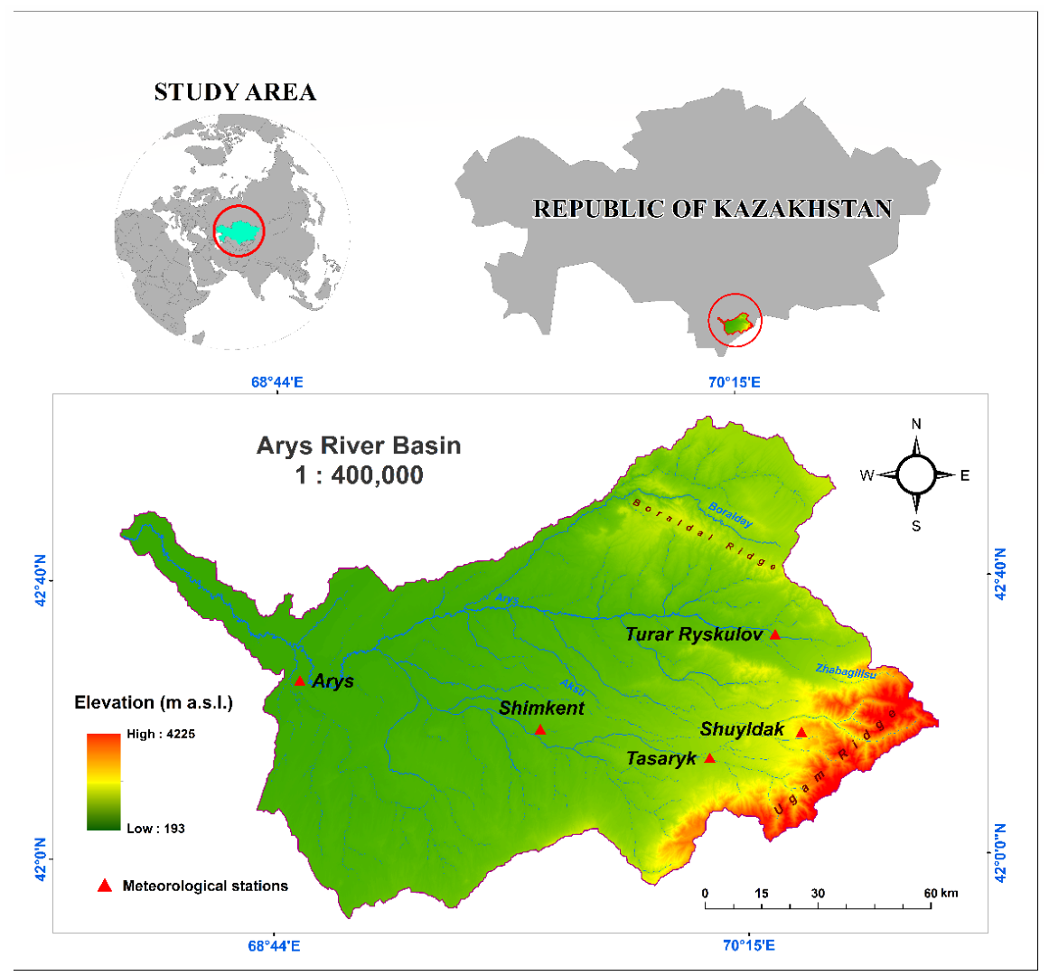
The Arys River, a major right-bank tributary of the Syr Darya, flows through southern Kazakhstan and is a complex mountain-plain watercourse of the Western Tien Shan (Figure 1). The river’s headwaters are located within the western spurs of the Talas Alatau, where the upper part of the catchment area is located at medium and high altitudes of about 1150 m above sea level between the ridges, with numerous tributaries developing from an altitude of about 2000–4000 m above sea level in the areas of glacial and snow-fed mountain systems. The total length of the river is about 378 km, and the area of its basin exceeds 14,900 km2, with the hydrological network covering significant altitude ranges, from high-mountain basins to flat areas at the mouth. The main tributaries (Badam, Mashat, and Aksu) contribute significantly to the spatial distribution of runoff and the formation of the basin’s hydrological network.
The climatic conditions of the basin vary significantly depending on altitude: in mountainous areas, winters are long and cold, with stable snow cover, while in lower altitude zones, winters are milder, and snow cover is unstable with frequent thaws. The summer period in the flat part is characterized by high air temperatures and significant evaporation, which increases the dependence of the water regime on the inflow of meltwater from mountainous areas.
According to data from the meteorological stations of the RSE “Kazhydromet” (period 1991–2020), the average annual precipitation within the Arys River basin varies from 200 to 250 mm in Turkestan to 550–600 mm in Shymkent, amounting to approximately 330–360 mm in the foothill areas (Taraz). The basin-averaged value is estimated at 300–450 mm/year, which reflects a pronounced orographic zonation of precipitation [50].
The Arys River basin is characterized by a clearly defined vertical zoning of the landscape, where alpine, subalpine, and foothill levels form the spatial distribution of snow reserves, which are essential for the hydrological regime of rivers and tributaries.
The average annual water discharge is 46.6 m3/s, decreasing to 9.68 m3/s in the lower reaches near the village of Sarkyrama [50]. The highest runoff occurs in April, and the lowest in August. The river’s hydrological regime is determined mainly by snowmelt in the upper reaches, as well as rain and surface runoff in the middle and lower reaches, which causes pronounced seasonal fluctuations in water flow, including spring floods. This is the classic flow regime for the mountain-plain rivers of the Tien Shan: spring snowmelt followed by summer depletion of moisture reserves. The river’s water resources are intensively used for irrigation of agricultural land, with the construction of reservoirs and irrigation systems having a direct impact on the distribution of runoff and hydrological processes in the valley [51].
Modern climate change, expressed through shifts in temperature and precipitation patterns, is leading to changes in the timing of snowmelt onset, a reduction in the duration of stable snow cover, and an alteration in the altitudinal boundary of its formation. In turn, this causes a redistribution of seasonal runoff, affects water availability for agricultural lands and populated areas, and impacts the operation of the region’s water management infrastructure.
In this context, assessing the long-term spatio-temporal dynamics of snow cover is of critical importance for understanding the processes of water resource formation in the Arys River basin and for developing effective adaptation measures under changing climate conditions.

2.2. Research Methods

This study employs a methodological approach focused on assessing snow cover as a spatially distributed source of river runoff formation in a mountainous basin. Given the insufficient density and uneven distribution of ground-based observations in the Arys River basin, the use of satellite remote sensing data is the most effective way to obtain homogeneous, comparable, and long-term information [12].
Particular importance is attached to satellite products that provide regular and temporally consistent snow cover mapping over large areas. Among them are the daily MODIS snow cover products from the Terra (MOD10A1) and Aqua (MYD10A1) satellites. These products offer high temporal resolution (daily observations from two satellites, allowing up to two scenes per day) and stable data continuity since the early 2000s, making them particularly suitable for monitoring snow cover dynamics at the scale of large river basins. This combination of characteristics makes them highly effective for basin-scale snow cover analysis, assessment of its spatial dynamics, and detection of interannual trends [34].
The choice of MODIS data is primarily justified for analyzing long-term snow cover dynamics at the level of a large mountainous basin. Priority was given to temporal continuity and full territorial coverage, as frequent cloud cover in mountainous regions, including Central Asia, significantly limits the availability of cloud-free imagery. The daily revisit frequency of MODIS observations, combined with cloud-removal algorithms implemented in the MODSNOW system, enables reliable tracking of rapid seasonal changes in snow cover and the accumulation of a homogeneous long-term dataset spanning more than 20 years [32]. This is critically important for evaluating the contribution of snow cover to river runoff and analyzing the impact of climate change on water resources.
Landsat and Sentinel data have higher spatial resolution (10–30 m compared to 500 m for MODIS) and indeed allow more detailed analysis of transitional zones. However, their use comes with several limitations. First, they have a lower observation frequency (e.g., every 5–16 days), which reduces the ability to track rapid changes, especially during snowmelt or snowfall periods. Second, the images have a high probability of data gaps due to cloud cover in mountainous areas. Third, there are issues with data comparability when constructing long time series (different sensors, missions, and calibrations), and processing data over large territories requires significantly greater computational resources and time [52].
Therefore, the selection of MODIS represents a well-justified compromise between spatial and temporal resolution. For analyzing long-term dynamics at the scale of the entire Arys River basin, the advantages of temporal continuity and operational efficiency outweigh the benefits of higher spatial detail, which are more critical for local or transitional zones. Thanks to these advantages, MODIS data are widely used in hydrological studies focused on assessing the impact of climate change on water resources.
Developed specifically for Central Asian countries, the automated snow cover monitoring system MODSNOW is a comprehensive algorithmic tool for processing satellite data, designed to obtain stable and comparable snow cover characteristics over time. The system is based on the use of daily MODIS snow cover products from the Terra (MOD10A1) and Aqua (MYD10A1) satellites, which provide twice-daily observation of the territory and increase the likelihood of obtaining cloud-free scenes [17,18].
The MODSNOW methodological scheme includes several sequential processing stages. The first stage involves automated downloading and preliminary filtering of the original satellite scenes, including pixel quality control using built-in reliability flags. This is followed by spatial alignment (mosaicing) of Terra and Aqua scenes, bringing them to a single coordinate system and a spatial resolution of 500 m.
By comparing pixels obtained at different times of the day, the system minimizes the impact of cloud cover, one of the main limitations of optical satellite observations. If an area is covered by clouds in one image, information from the second satellite is used, which significantly reduces the proportion of uncertain pixels and increases the completeness of coverage. Additionally, filtering and temporal interpolation procedures are applied to eliminate short-term noise and anomalies in daily data.
Unlike model approaches based on calculations of snow cover using meteorological parameters (air temperature, precipitation, radiation balance), MODSNOW relies exclusively on direct satellite observations of surface reflectivity in the visible and near-infrared ranges [16]. This reduces the dependence of the results on model parameterization and the density of the ground-based meteorological network, which is especially important for the mountainous regions of Central Asia with a limited number of stations. The result is a consistent and homogeneous time series of snow cover area (SCA) suitable for analyzing seasonal dynamics, interannual variability, and long-term trends [31].
Previously, the MODSNOW system was used to analyze snow cover in the region’s largest river basins, including the Amu Darya and Syr Darya basins, where it demonstrated high reproducibility and resistance to data gaps [34]. However, this is the first time this tool has been used for the Arys River basin, allowing for results comparable to regional studies to be obtained and integrated into a broader context of regional water resource assessment.
In this study, the MODSNOW system was not used to estimate snow depth or Snow Water Equivalent (SWE), but exclusively to analyze the spatiotemporal dynamics of the area covered by snow. This choice is due to the fact that it is the area of snow cover in mountain basins that acts as an indicator of snow accumulation and subsequent melting, determining the phase and intensity of spring floods.
Thus, the methodological approach used combines the advantages of regular satellite observations, automated processing, and regional adaptation of algorithms. This provides an objective, reproducible, and spatially detailed assessment of snow cover dynamics in the Arys River basin and creates a reliable basis for interpreting the results obtained in the context of water resource formation and climate variability.
Spatial processing and visualization of the MODSNOW snow cover data were performed in ArcGIS Pro 3.6 (Esri, Redlands, CA, USA) using the WGS84 coordinate system. A digital elevation model (DEM) was used to analyze the altitudinal distribution of snow cover.
The MODSNOW-derived snow cover maps were verified against daily snow cover observation data from five meteorological stations covering the period from 2000 to 2024 (24 years) (Table 1). These verification stations (Shymkent, Tasaryk, T. Ryskulov, Shuyldak, and Arys) represent the diverse altitudinal and climatic conditions within the basin. The consistency between satellite and ground-based data was assessed using a confusion matrix, from which the overall accuracy, precision, recall, and the F1 score were calculated. The resulting mean accuracy of approximately 89.5% indicates the high reliability of the MODSNOW system for determining snow cover at the basin level [17,25].
A time series of snow-covered area during the cold season (October–April) was constructed for the period 2000–2024. To evaluate long-term changes in snow cover, the non-parametric Mann–Kendall test was applied [53,54,55]. This test identifies monotonic trends in time series without requiring assumptions of data normality and is robust to outliers and missing observations, making it highly suitable for analyzing hydroclimatic variables. The magnitude of any identified trend was quantified using Sen’s slope estimator, which is calculated from all possible pairwise values in the time series. This measure estimates the rate of change in snow cover area (% per year) and reduces the influence of extreme values on the analysis [56].
The methods applied in this study have several limitations. The spatial resolution of MODIS data (500 m) may be insufficient for detailed mapping of small-scale snow cover changes in complex mountainous terrain [13]. Furthermore, the MODSNOW system is not designed to estimate snow depth or snow water equivalent; therefore, the results reflect spatial distribution patterns rather than absolute snow reserves. Nevertheless, the methodological approach used here remains sufficiently reliable for long-term comparative analysis and trend detection in snow cover dynamics.

3. Results

River flow in the Arys River basin is largely determined by the melting of seasonal snow cover accumulated in mountainous areas, with most of the annual flow occurring in the spring and summer. Rising air temperatures during this period accelerate snowmelt, forming flood flows. The spatial and temporal characteristics of snow cover—its depth, density, and duration—control the magnitude and seasonality of runoff, while interannual variability in winter snowfall determines the likelihood of low-water and high-water years [49]. Long-term monitoring of these parameters enables the identification of trends in the transformation of the hydrological regime under the influence of climatic factors, including temperature and precipitation fluctuations, as well as anthropogenic pressures associated with water abstraction and irrigation systems. Analysis of the spatial and temporal dynamics of snow cover provides a scientific basis for forecasting water balance, rational water resource management, and the development of adaptation strategies in the Arys River basin.
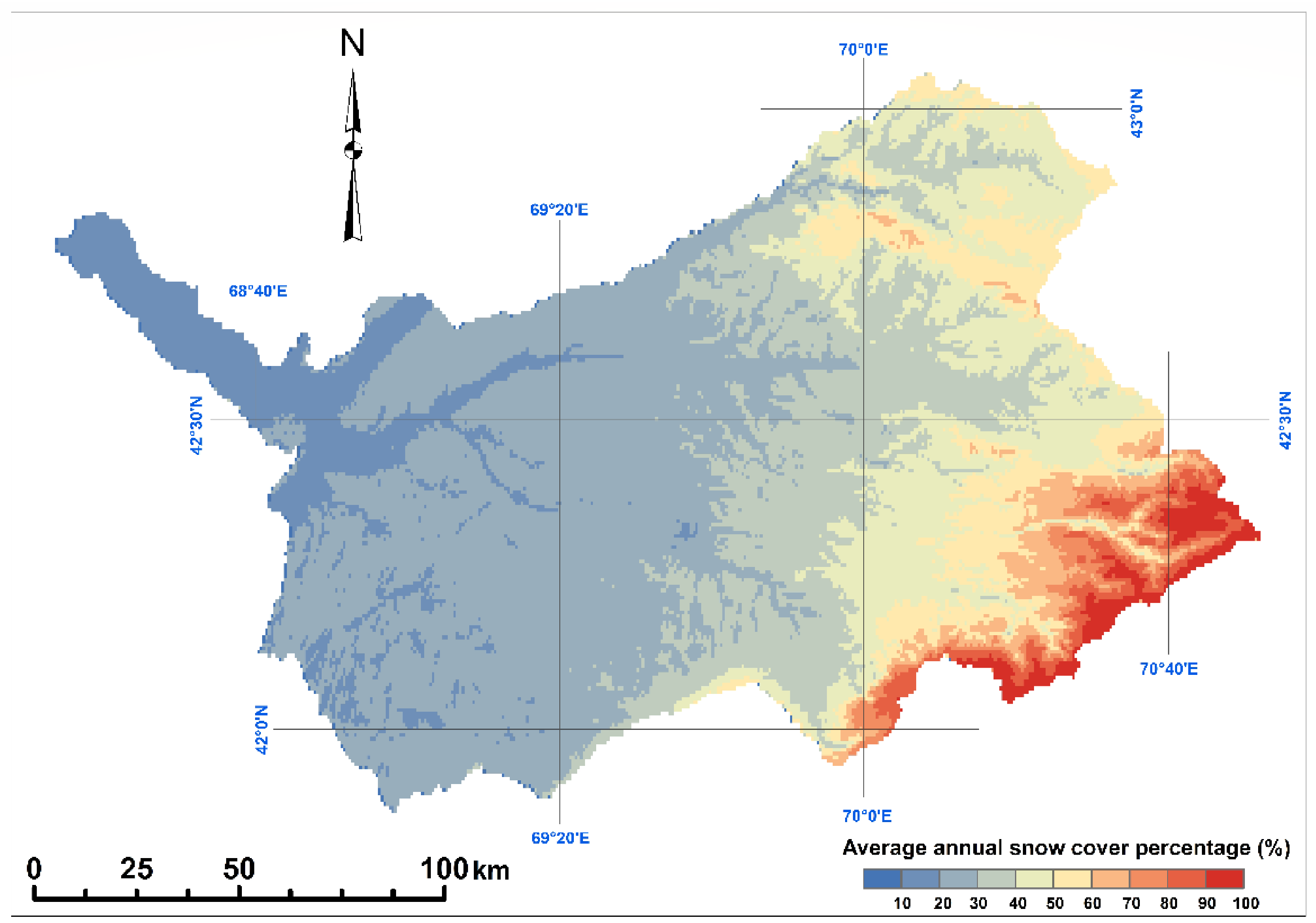
For a more detailed understanding of the impact of snow cover on runoff formation, it is necessary to consider its spatial distribution within the basin. The long-term average distribution of snow cover, estimated using the MODSNOW system, is characterized by pronounced altitudinal zonality. Stable and long-lasting snow is mainly concentrated in the mountainous areas of the southeastern part of the basin, especially at altitudes above 3000 m, where the average proportion of snow-covered territory reaches 80–95% (Figure 2). This is due to a combination of low temperatures and an enhanced orographic effect of precipitation in high mountain areas. In contrast, in the plains and foothills of the northwestern part of the basin, snow cover is highly unstable, with an average coverage during the cold season not exceeding 10–20%. Frequent thaws and the predominance of liquid precipitation contribute to the rapid destruction of snow.
To validate the accuracy of the MODSNOW satellite data, records from five meteorological stations—Shymkent, Tasaryk, Turaar Ryskulov, Shuuldak, and Arys—were used. The data were obtained from the archives of the RSE “Kazhydromet”. These stations perform daily instrumental measurements of snow depth (in cm). The presence or absence of snow cover at each station was determined based on these ground-based measurements (Table 2). The need to verify MODIS satellite snow products against in situ observations has been demonstrated in previous studies by other researchers [16,25,30,57].
The selected meteorological stations cover a variety of natural landscapes—from plains to mountainous areas—which allowed the algorithm’s performance to be evaluated across different geographical zones. The comparison was performed using the single-pixel method, which more accurately accounts for local terrain and snow cover characteristics while reducing the influence of mixed signals from different surface types within a single satellite pixel. MODSNOW values at the grid point corresponding to each station’s coordinates were compared with actual ground observations.
For each day, matches and errors were identified: True Positives (TP), True Negatives (TN), False Positives (FP), and False Negatives (FN). Based on these, the following metrics were calculated: Accuracy (overall proportion of correct classifications), Precision, Recall (sensitivity), and F1 Score (the balanced measure of precision and recall) (Table 2).
In this study, a binary classification approach was applied to snow cover (snow/no snow), with the Normalized Difference Snow Index (NDSI) serving as the primary indicator using a threshold value of ≥0.4.
The average quality metrics of MODSNOW were evaluated against ground-based measurements using the following indices:
Accuracy = (TP + TN)/(TP + TN + FP + FN);
Precision = TP/(TP + FP);
Recall = TP/(TP + FN);
F1 = 2 × (Precision × Recall)/(Precision + Recall);
where TP—True Positives, TN—True Negatives, FP—False Positives, and FN—False Negatives.
According to the table, the average elevation of the stations is 943.4 m, with a range from 240 m (Arys) to 1947 m (Shuyldak). This provides a representative sample for analysis under conditions of pronounced altitudinal zonation.
The average values of the quality metrics indicate that the MODSNOW algorithm demonstrates fairly high performance: Accuracy—89.5%, Precision—86.1%, Recall—90.8%, F1 Score—87.4%. The high Recall value reflects the model’s ability to effectively detect snow cover while minimizing omissions. However, the slightly lower Precision indicates the presence of false positive classifications, which is typical for satellite-based methods in areas with complex underlying surfaces.
Station-level analysis revealed significant spatial heterogeneity in performance: Arys station (240 m) shows the best results across all metrics (Accuracy—92.4%, F1—94.7%). This may be due to simpler snow cover detection conditions in the lowland area, where shadowing effects and complex orography are minimal.
Shuyldak station (1947 m) exhibits the highest Precision (95.0%), but a lower Recall (87.8%) indicates partial omissions of snow cover. This can be attributed to the influence of mountainous terrain, cloud cover, and snow heterogeneity.
Tasaryk and T. Ryskulov stations (mid-mountain zones) demonstrate balanced metrics (F1 ≈ 86–87%), indicating stable algorithm performance in transitional altitudinal zones.
Shymkent station (604 m) shows the lowest overall accuracy (F1—78.6%) and particularly low Precision (75.0%), indicating a considerable number of false detections. This is likely due to characteristics of the underlying surface, such as urbanization, vegetation, and wet soils, which complicate accurate classification.
Overall, validation using data from the five meteorological stations confirms that MODSNOW is a reliable tool for snow cover monitoring. Nevertheless, its accuracy is influenced by the specific environmental and physiographic conditions of the study area.
The reliability of the MODSNOW product is further corroborated by ground-based validation. An average accuracy of approximately 90% obtained through this verification process indicates that the satellite-derived snow cover maps are sufficiently accurate for long-term analysis at the basin scale.
The time series of the proportion of the Arys River basin covered by snow during the cold season (November–March/April) for the period 2000–2024 is characterized by high interannual variability. According to MODSNOW data, the minimum average seasonal snow cover was 16.2%, the maximum was 54.1%, with a long-term average of 34.4%. The standard deviation of the time series reaches 8.8%, which indicates a significant influence of interannual fluctuations in atmospheric circulation, in particular, the intensity of the western transport, Arctic intrusions, and blocking anticyclones, on snow accumulation in the region.
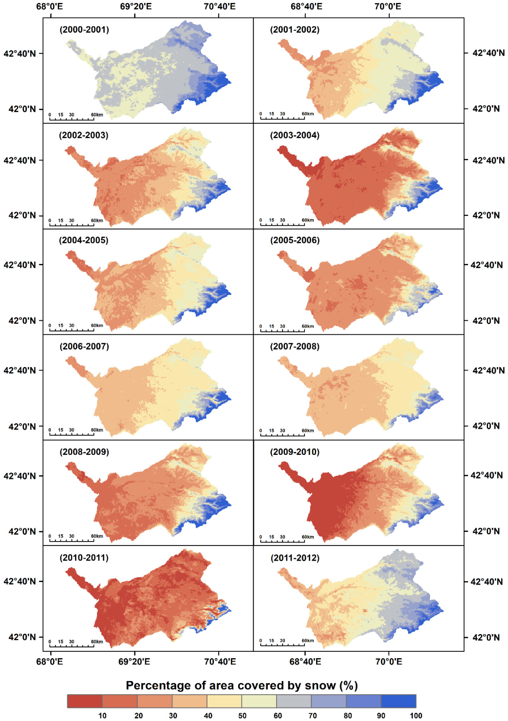
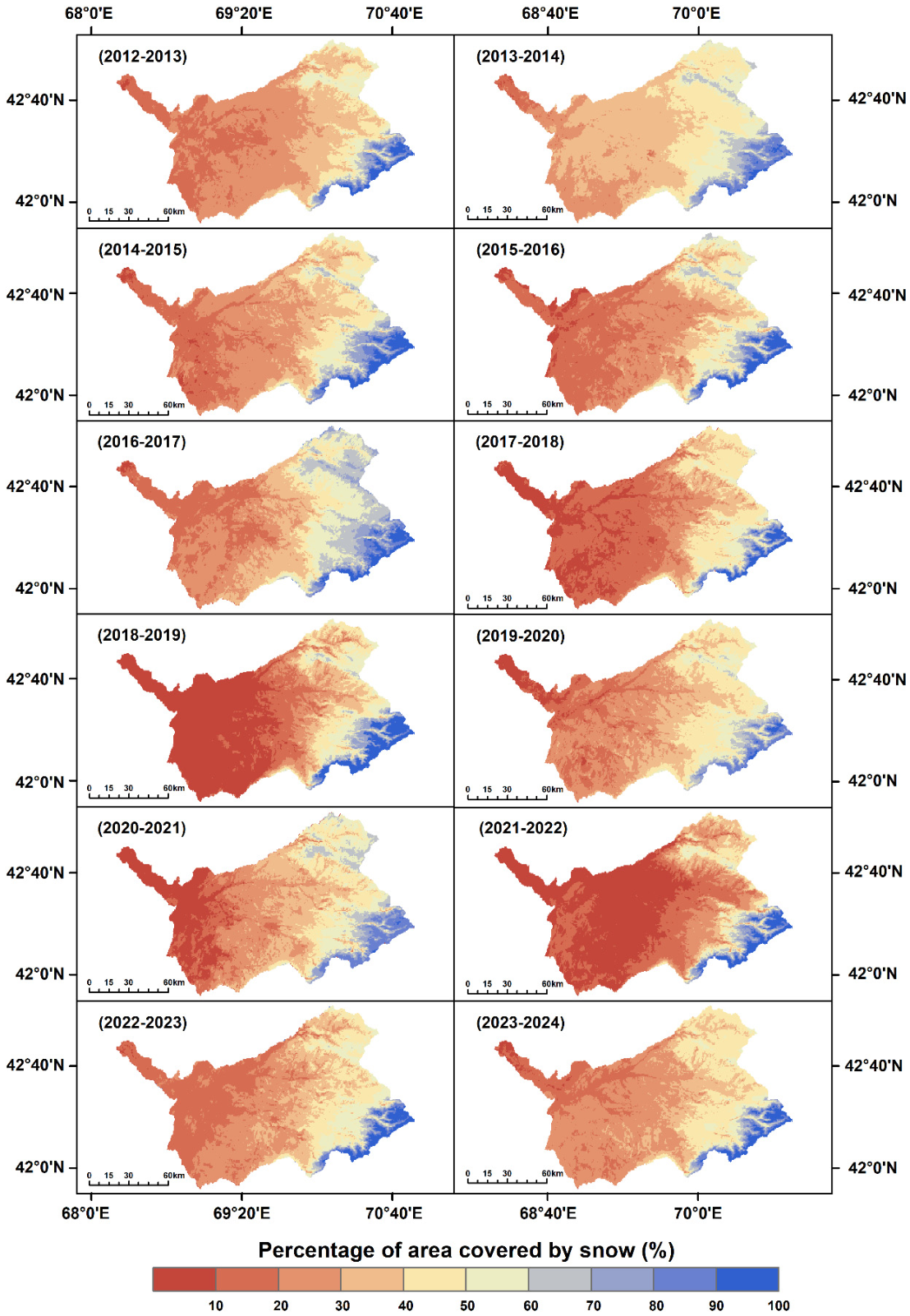
Spatial maps of the average snow cover distribution for each cold season (Figure 3 and Figure 4) clearly illustrate the pronounced heterogeneity of snow cover within the basin. The highest values of coverage (70–100%) are consistently observed in the southeastern mountainous part of the basin (altitudes > 2500–3000 m, western and northwestern slopes of the Talas Alatau and spurs of the Zailiyskiy Alatau). At the same time, the western and northwestern foothills and plains, mainly occupied by agricultural land and semi-deserts, are characterized by low snow cover (on average < 20–25%, often 10–15%). The transitional foothill zone (altitudes 800–1800 m) shows intermediate values of about 25–35%.
The snowiest years in the period under review are: 2000–2001 (66%), 2011–2012 (54%), 2001–2002 (49%), and 2006–2007 (44%).
The average snow cover percentage during these extremely snowy seasons was 53.3%. The maps for these years (especially 2000–2001 and 2011–2012) show a significant expansion of the coverage area ≥ 50–70% in mountainous and foothill areas, as well as the penetration of snow cover (30–50%) into the western flat parts of the basin (Figure 3). This finding aligns with the well-documented high interannual variability of snow cover across Central Asia [9]. Such anomalously snowy winters in the region are traditionally associated with distinctive atmospheric circulation patterns, including the strengthening of western zonal flow and increased cyclonic activity [21], as well as lower air temperatures that favor a greater proportion of solid precipitation [20]. Given the critical role of snow cover in the formation of river runoff in the mountainous basins of Central Asia [58], such years exert a substantial influence on the regional hydrological regime.
In contrast, years with little snow (e.g., 2007–2008, 2008–2009, 2019–2020, 2022–2023, 2023–2024) are characterized by a sharp reduction in the snow cover area: values < 30% prevail even in the mid-mountains, and in the foothills and plains, the proportion often falls below 10–15% (Figure 4).
Analysis of maps for the entire period 2000–2024 reveals a general trend towards a reduction in the area and intensity of snow cover, which is particularly noticeable after 2010–2012. In the last 10–12 years (2012–2024), seasons with a lower proportion of cover have prevailed compared to the first decade of observations. The reduction is particularly evident in the mid-mountain zones (1500–2500 m), where values of 40–70% were previously observed, but in recent years have often fallen to 20–40%. Mountainous areas retain relatively high values (>60–80%), but the area of such zones is gradually decreasing.
The results of trend analysis confirm this picture: the Sen slope coefficient is −0.37% per year. The Mann–Kendall test revealed a weak negative trend, but it is statistically insignificant (p = 0.25). The lack of significance is largely explained by high interannual variability, which masks the long-term climate signal, as well as the relatively short observation series (25 years).
The results obtained are consistent with regional studies on the Tien Shan and the Syr Darya basin [7,9,59]. The literature notes a reduction in the duration of snow cover by 0.5–0.7 days per year in the upper reaches of the Syr Darya (2000–2022), a decrease in the seasonal duration of snow in the middle reaches of the Tien Shan, a decrease in the proportion of precipitation falling as snow, and an overall reduction in snow reserves due to warmer winters and earlier melting [1,18].
From the perspective of water resource management in the Arys River basin and the entire Syr Darya basin, the results underscore the critical importance of snow cover monitoring. Even in the absence of a statistically significant linear trend, the observed reduction in snow cover in the middle and low mountain belts is already leading to changes in the spring-summer runoff regime: a shift in the flood peak to earlier dates, a reduction in the volume of meltwater during the growing season, and an increased risk of low water levels in dry years. Abnormally warm winters (with rain instead of snow) further exacerbate this effect.
The average annual seasonal variability of snow cover is characterized by a pronounced pattern determined by the annual air temperature cycle and solar radiation balance [4,7,60].
Stable snow cover usually establishes itself in November, followed by intensive accumulation in December. Maximum coverage is reached in January, when the average annual proportion of snow-covered territory is 66.2%—the highest value in the cold season.
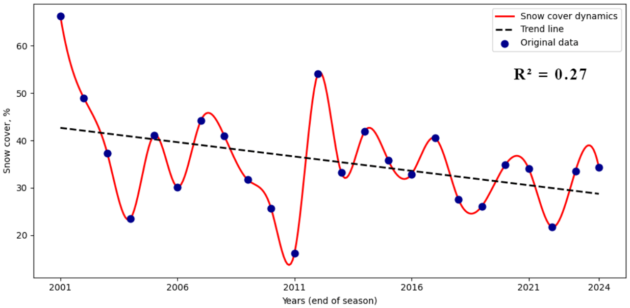
From February, the snow cover area begins to gradually decrease; in March–April, the intensity of ablation increases sharply due to rising temperatures and increased total insolation. During the summer months (July–September), the snow cover almost completely disappears in most foothill and mid-mountain areas. The minimum average annual proportion of snow-covered area is recorded in September and amounts to 1.8% (Figure 5).
The graph shows the long-term dynamics of the end-of-season snow cover area (usually estimated at the end of the melting period, most often in May–June) for the period from approximately 2001 to 2024. The baseline values—i.e., the average snow cover fraction in the Arys River basin calculated from MODSNOW data—show significant interannual variability, ranging from 15 to 20% to 50–65% in certain years. The smoothed curve highlights quasi-cyclical fluctuations with a characteristic period of 4–6 years, which are associated with the influence of large-scale atmospheric oscillations such as the El Niño–Southern Oscillation, capable of modulating temperature and precipitation anomalies across Northern Eurasia [61,62]. The North Atlantic Oscillation and the Arctic Oscillation [63] also affect the temperature regime and precipitation distribution in Eurasia, along with regional climate variability and snow–albedo feedback mechanisms.
At the same time, the linear trend clearly indicates a persistent decrease in snow cover extent of approximately 10–15% over the study period—from about 42% in the early 2000s to 28–30% in recent years.
The negative trend in end-of-season snow cover is consistent with numerous studies documenting an overall reduction in snow duration, seasonal snow cover area, and snow reserves in the Tien Shan mountains and adjacent regions of Central Asia under the influence of regional warming (especially in the winter-spring period). This is manifested in an earlier onset and acceleration of snowmelt, especially at altitudes below 3000–3500 m, as well as in a shift in the precipitation phase from solid to liquid form.
This dynamic is critical for the region’s hydrological regime, as seasonal snow cover in the Tien Shan mountains is the main source of water for transboundary rivers during the warm season. The reduction in the final area and volume of snow increases the risk of spring-summer low water levels, reduces accumulated water reserves for irrigation, hydropower, and water supply, and increases vulnerability to extreme hydrological events.
The identified seasonal cycle is closely determined by changes in the thermal regime and radiation balance in mountainous areas. The long-term negative trend in end-of-season snow cover reflects the pronounced influence of anthropogenic climate warming and regional circulation shifts over the past two to three decades, which is consistent with the findings of a number of studies on the cryosphere of the Tien Shan and adjacent mountain systems.
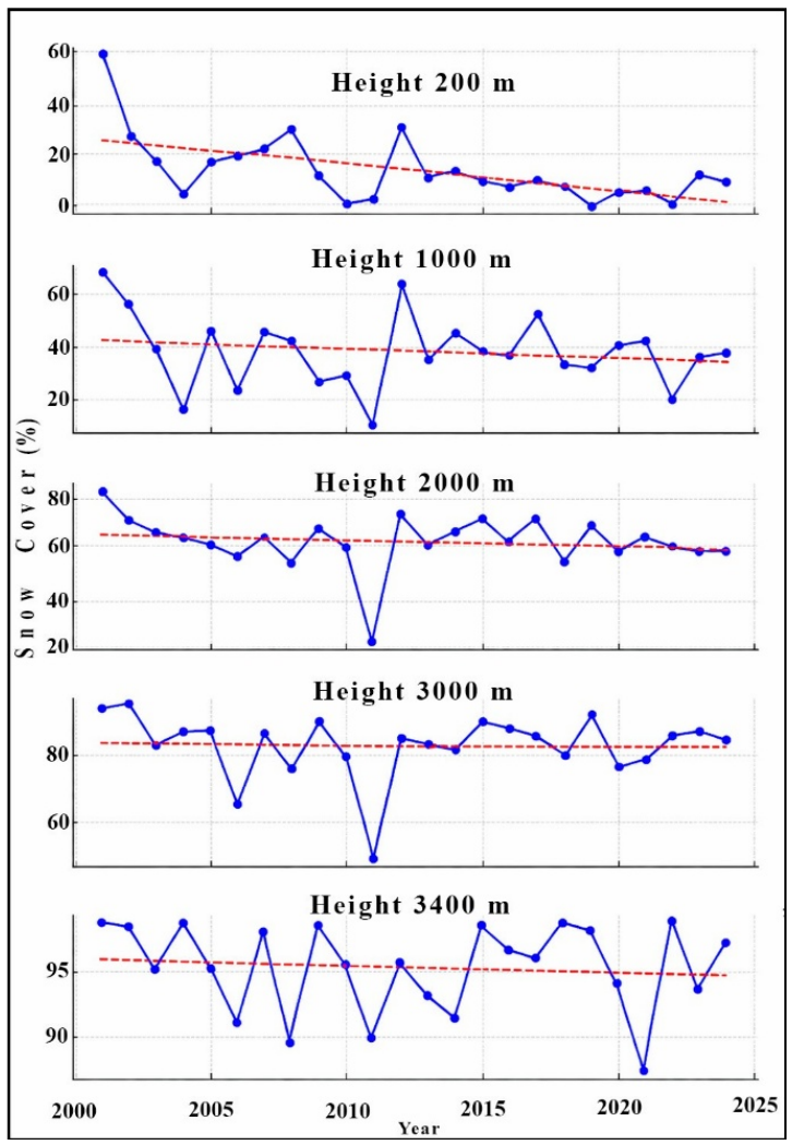
For the study period (2000–2024), statistics on the mean snow-covered area (SCA) fraction are presented with respect to elevation at 1000 m (Figure 6) intervals and for individual months (Figure 7).
The analysis of the vertical distribution of snow cover revealed a clear altitudinal differentiation of trends, reflecting the rise in the snow line against the background of modern climate warming.
Based on the data from Table 2, the most intense reduction in snow cover occurs at low and middle altitudes. In the foothills (200 m, Aryss station, 204 m), the average proportion of snow-covered area decreased from 58 to 60% in 2000–2001 to 5–10% in 2020–2025. At 1000 m (Tasaryk station, 1117 m), the share declined from 68 to 70% to 35–40%. Both levels are characterized by high interannual variability.
At 2000 m (Shuyldak station, 1947 m), the trend is weakly negative or absent, with average values stabilizing around 62%. In the high-mountain zone (3000–3400 m), snow cover remains stable: approximately 82% at 3000 m and 94–96% at 3400 m, with low interannual variability. The deep minimum in 2011 manifested synchronously across all altitudes, indicating the regional nature of the climatic anomalies.
The obtained results illustrate a pronounced altitudinal asymmetry in the cryosphere’s response to climate change. The intense reduction in snow cover at low and middle altitudes is consistent with rising winter temperatures and/or a decrease in the proportion of solid precipitation, leading to accelerated melting and a shorter snow cover duration. At the same time, at altitudes ≥ 2000 m, the temperature threshold required for sustained snow cover has not yet been exceeded in most years, ensuring relatively stable conditions in the high-mountain zone. The decrease in interannual variability with increasing elevation further emphasizes the transition from a highly dynamic snow regime in the lower belts to a more stable regime in the glacial-nival belt.
The synchronicity of deep snow cover minima (especially in 2011) across all altitudinal levels indicates the regional character of climatic anomalies that affected the entire elevation profile of the studied mountain system.
In general, MODSNOW is effective for the Arys basin, but requires additional validation in high-mountain zones, since the Arys River basin covers an altitude range from approximately 400–600 m in the foothills and valleys to maximum elevations of approximately 4240 m (Sairam peak in the Ugam range) (Figure 1).
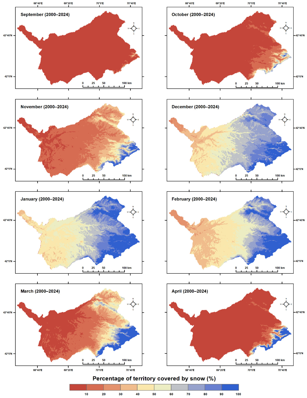
The Arys River basin covers an altitude range from approximately 400–600 m in the foothills and valleys to a maximum of about 4240 m (Sairam Peak in the Ugam Range), including significant areas of the middle and high mountains of the Talas Alatau, the Ugam Range, and adjacent spurs (Figure 7).
Seasonal dynamics in the basin are characterized by minimal snow cover in September–October, when there is virtually no snow cover or it is extremely low (<10–20%) over most of the basin, except for local high-altitude areas (above ~3500–3800 m) in the southeast and east of the basin, where values reach 30–60%. This corresponds to the end of the period of intense ablation and the beginning of accumulation in the upper altitude zones.
It is known that active accumulation begins in November and, in this case, the cover increases to 40–70% at altitudes above 3000 m (especially in the eastern part of the basin), while in the low and middle mountains (below 2500–2800 m), low values (10–40%) remain.
In December–February, the peak of winter snow cover development is reached. Above 3200–3400 m, the coverage ratio consistently exceeds 90–100%, forming a belt of permanent snow cover. As can be seen from the map, in the 2800–3200 m range, the values are 70–95%, and below 2500–2800 m there is a sharp decrease (to 30–60% even in January–February), which is due to the influence of temperature inversions, higher winter temperatures in the valleys and foothills, as well as less solid precipitation in the lower belts.
It is natural that with the onset of spring, in March–April, the region begins a process of intense ablation, with snow remaining only above 3000–3200 m (60–100%), but already in April, in low- and medium-altitude zones, the coverage falls below 20–30%, while in the high mountains, high values are maintained only at the highest levels (>3800 m).
The maximum average annual snow cover values are recorded in the altitude range of 3800–4000 m, where the average proportion reaches 98.6%. Above 3200 m, the average annual coverage percentage consistently exceeds 95%. This vertical zoning is determined by negative average air temperatures during the cold period, high orographic precipitation condensation on the windward slopes of the Western Tien Shan, and minimal melting intensity in the high mountains, where the remains of modern glaciers and perennial snowfields are also located.
In the middle and low mountain belts of the Arys River basin (below 3000–3200 m), the snow cover is highly unstable: rapid accumulation in late autumn and intense melting in spring, which is typical for transitional altitude zones with variable precipitation and temperature regimes. In the highlands, the regime is much more stable, but interannual variability persists. Certain years (in particular, 2010–2011 and 2021–2022) are notable for abnormally high or low coverage even in the upper altitude zones. Such deviations are usually associated with extreme features of atmospheric circulation (intensification of westerly transport, Arctic intrusions, blocking anticyclones) and variations in the volume of solid precipitation in winter.
The patterns obtained are consistent with the results of studies of snow cover in the western and northern Tien Shan based on satellite data (MODIS, etc.) for similar periods. The zone of maximum stability and duration of snow cover is located above 3000–3200 m, with a sharp decrease below this level. In high mountain belts (>3500–3800 m), negative trends in the area and duration of the snow season prevail, associated with an increase in air temperature (especially in transitional seasons). In the mid-mountain zone (1500–3000 m), there is increased interannual variability, depending on slope exposure and regional moisture characteristics.
The altitudinal stratification of snow cover in the Arys River basin is primarily determined by the thermal gradient (about 6 °C/km in the lower and middle parts) and the orographic redistribution of precipitation. The zone of stable snow cover (>95%) is consistently located above 3200 m, and the maximum average annual values of the average coverage are reached in the 3800–4000 m belt, where accumulation dominates over ablation during most of the cold season. Seasonal transitions are accompanied by a sharp increase in snow in November–December and intense melting in March–May in the lower and middle belts, while high-altitude zones show significantly greater stability. The identified anomalous years highlight the importance of further analysis of meteorological and circulation factors to explain interannual variability.
Changes in snow cover extent within the Arys River basin have direct hydrological implications, as snowmelt is the primary driver of the volume and timing of spring and summer runoff. A reduction in the SCA fraction during the cold season, particularly within the mid-elevation zones (2000–3000 m), may reduce the volume of meltwater contributing to spring runoff.
A decline in snowpack across these zones may also prompt an earlier onset of snowmelt and an advance in the peak spring discharge. For the Arys River basin, this elevates the risk of a mismatch between the period of maximum water yield and the peak agricultural water demand, which typically occurs in the summer months.
Consequently, the identified declining trend in snow cover may be interpreted as an indicator of potentially increased intra-annual runoff variability and heightened water scarcity during the summer season.

4. Discussion

This study presents an analysis of the spatiotemporal dynamics of snow cover in the Arys River basin from 2000 to 2024. The results reveal a general declining trend in snow cover extent during the cold season, concurrent with high interannual variability. This combination of a subdued long-term signal superimposed on substantial interannual fluctuations is a characteristic feature of Central Asian mountain regions and has been documented in a number of studies [1,2,3,4].
A comparison of the results obtained with studies conducted for other basins in Central Asia shows good consistency. Thus, studies [29,30,32,33,35,37,38] based on MODIS data for large river systems in the region (including the Syr Darya, Amu Darya, and Tien Shan basins as a whole) reveal a trend toward a reduction in snow cover, which is particularly pronounced in the mid-mountain altitude zones (1500–3000 m).
Regional assessments for the periods 2000–2022 (including cloud-cleared MODIS products) record an overall decrease in the duration of snow cover and coverage area in the mid-mountain range, with negative trends prevailing in the transitional seasons (spring and autumn). In high mountain areas (>3500 m), trends are often less pronounced or locally opposite (increased accumulation with increased precipitation in some subregions), but overall, negative changes associated with accelerated melting and a shift in precipitation from snow to rain prevail in the Western Tien Shan and adjacent areas. High interannual variability, which masks the long-term trend, is also widely observed: extremely snowy winters alternate with low-snow winters, making it difficult to identify statistically significant trends.
Unlike regional assessments covering large areas, this study focuses on a single river basin, allowing for a more detailed interpretation of changes in snow cover in the context of water resource formation in the Arys River, an important tributary of the Syr Darya in its lower reaches.
The identified changes in snow cover within the 2000–3000 m elevation range are of particular importance, as this zone plays a critical role in accumulating seasonal snowpack. Winter temperatures in these belts are highly sensitive to warming, where even minor thermal regime shifts can induce substantial alterations in snow accumulation and ablation processes. These results corroborate the consensus that mid-mountain regions are among the most vulnerable to climate change and are a primary contributor to observed snow cover dynamics.
For the Arys River basin, where water consumption is largely linked to irrigated agriculture in the foothills and valleys, such changes may exacerbate intra-annual variability in water resources and increase the risk of water shortages during periods of peak demand (July–August). In the broader context of the Syr Darya basin, similar shifts lead to an earlier peak in flow and increased extremes in the hydrograph, exacerbating the risks of spring floods and summer low flows in the transboundary region.
It is important to note that the identified declining trend lacked statistical significance according to the Mann–Kendall test (p = 0.25). However, the absence of statistical significance does not preclude physically plausible changes. High interannual variability in snow cover, compounded by episodic extreme snow years, can obscure long-term trends, a common characteristic of hydroclimatic time series. Within this context, the negative slope estimated by Sen’s method suggests a potentially persistent direction of change warranting further investigation.
A key strength of this study is the application of the automated MODSNOW monitoring system. Integrating data from both Terra and Aqua satellites mitigated cloud obscuration and generated consistent, long-term snow cover time series, a capability validated against ground station data (~90% accuracy). This performance confirms the utility of MODSNOW for long-term snow cover monitoring and change assessment in mountainous basins.
In summary, these findings augment the existing body of knowledge on the response of Central Asian mountain snow cover to climate change [5,8,9] and underscore the necessity of integrating snow hydrology into water resource analyses. For the Arys River basin, observed snow cover changes may serve as an early indicator of impending streamflow alterations, providing critical insight for water management planning and climate adaptation strategies. Future research should leverage high-resolution satellite data and hydrological modeling to achieve a more granular assessment of spatiotemporal snow cover dynamics and their impact on water resource formation.
A promising direction for the future is the use of high-resolution satellite data (Sentinel-2, Landsat) in combination with hydrological models to quantify the contribution of snow cover changes to runoff, predict peak and minimum flows, and develop adaptation scenarios for water management planning in the context of ongoing warming. Such approaches will allow for more accurate modeling of the impact on the transboundary water resources of the Syr Darya and contribute to sustainable management in the region.

5. Conclusions

This study presents a comprehensive assessment of the spatiotemporal dynamics of snow cover in the Arys River basin, situated in the Western Tien Shan Mountains, from 2000 to 2024. Our analysis integrated MODIS Terra/Aqua satellite data, the automated MODSNOW monitoring system, and in situ meteorological observations. The application of Terra-Aqua composites effectively mitigated the impact of persistent cloud cover typical of mountainous regions, enabling a robust, basin-scale analysis of snow cover.
The key findings are as follows:
  • Snow cover distribution across the basin exhibits a distinct altitudinal gradient. Persistent snowpack is confined primarily to high-elevation areas (>3000 m), whereas mid- and low-elevation zones are subject to high interannual variability. The mid-elevation belts are of critical importance, serving as the primary zones for seasonal snowpack accumulation and exerting a dominant influence on river runoff.
  • Analysis of the time series for 2000–2024 identified a declining trend in the cold-season snow-covered area fraction (SCA), with Sen’s slope estimator indicating a reduction of approximately 0.37% per year. Although the Mann–Kendall test did not deem this trend statistically significant, likely due to high interannual variability and episodic high-snow years masking the long-term signal, the consistently negative slope suggests a physically plausible and gradual decline.
  • Validation against ground observations from Kazhydromet confirmed the high reliability of MODSNOW, with a mean classification accuracy of ~90%. This performance demonstrates the system’s efficacy for long-term snow cover monitoring in mountainous basins like the Arys. It was also noted that snow cover instability in lower elevations can affect point-to-pixel validation consistency.
  • The observed snow cover reduction poses potential risks to seasonal water resources. Earlier snowmelt onset may advance the spring freshet peak and exacerbate summer water shortages, with significant implications for the basin’s irrigated agriculture and for socio-economic systems dependent on the Syr Darya’s resources.
In summary, this study provides one of the first detailed analyses of snow cover dynamics in the Arys River basin using satellite data. The findings underscore the critical role of snow cover as a key indicator of water resource status in mountain basins. Future efforts to integrate satellite-based snow cover products with hydrological modeling and water use data hold strong potential to enhance water resource forecasting accuracy and strengthen climate resilience across the arid regions of Central Asia.

Author Contributions

Conceptualization, A.K. and Z.T.; methodology, Z.T. and A.M.; software, Z.T.; validation, A.B.; formal analysis, D.K.; investigation, Z.S.; resources, A.Z.; data curation, Z.T.; writing—initial draft preparation, A.K.; writing—review and editing, A.K. and Z.T.; visualization, A.M.; scientific supervision, A.K. and A.G.; project administration, Z.T. and A.G.; funding acquisition, Z.T. All authors have read and agreed to the published version of the manuscript.

Funding

This research was funded by the Central Asian Regional Glaciological Centre (Category 2 under the auspices of UNESCO), Almaty, Kazakhstan. The APC was funded by the Central Asian Regional Glaciological Centre (Category 2 under the auspices of UNESCO), Almaty, Kazakhstan.

Data Availability Statement

The MODIS snow cover data (MOD10A1 and MYD10A1 products) used in this study are publicly available from the NASA National Snow and Ice Data Center (NSIDC) at https://nsidc.org/data, accessed on 5 March 2026. Processed snow cover data generated during the study are available from the corresponding author upon reasonable request.

Acknowledgments

The authors thank the Central Asian Regional Glaciological Centre (Category 2 under the auspices of UNESCO), Almaty, Kazakhstan, for institutional support.

Conflicts of Interest

The authors declare no conflict of interest.

References

  1. Janusz-Pawletta, B.; Gubaidullina, M. Transboundary Water Management in Central Asia. Legal Framework to Strengthen Interstate Cooperation and Increase Regional Security. Cah. d’Asie Cent. 2015, 25, 195–215. [Google Scholar]
  2. Karthe, D.; Abdullaev, I.; Boldgiv, B.; Borchardt, D.; Chalov, S.; Jarsjö, J.; Li, L.; Nittrouer, J. Water in Central Asia: An integrated assessment for sciencebased management. Environ. Earth Sci. 2017, 76, 690. [Google Scholar] [CrossRef] [Scilit]
  3. Immerzeel, W.W.; van Beek, L.P.H.; Bierkens, M.F.P. Climate change will affect the Asian water towers. Science 2010, 328, 1382–1385. [Google Scholar] [CrossRef] [Scilit] [PubMed]
  4. Aizen, V.B.; Aizen, E.M.; Melack, J.M.; Dozier, J. Climatic and hydrologic changes in the Tien Shan, Central Asia. J. Clim. 1997, 10, 1393–1404. [Google Scholar] [CrossRef] [Scilit]
  5. Barlow, M.A.; Tippett, M.K. Variability and predictability of Central Asia river flows: Antecedent winter precipitation and large-scale teleconnections. J. Hydrometeorol. 2008, 9, 1334–1349. [Google Scholar] [CrossRef] [Scilit]
  6. Barnett, T.P.; Adam, J.C.; Lettenmaier, D.P. Potential impacts of a warming climate on water availability in snow-dominated regions. Nature 2005, 438, 303–309. [Google Scholar] [CrossRef] [Scilit]
  7. Sorg, A.; Bolch, T.; Stoffel, M.; Solomina, O.; Beniston, M. Climate change impacts on glaciers and runoff in Tien Shan (Central Asia). Nat. Clim. Change 2012, 2, 725–731. [Google Scholar] [CrossRef] [Scilit]
  8. Tang, Z.; Wang, X.; Wang, J.; Wang, X.; Li, H.; Jiang, Z. Spatiotemporal variation ofsnow cover in Tianshan Mountains, Central Asia, based on cloud-free MODISfractional snow cover product, 2001–2015. Remote Sens. 2017, 9, 1045. [Google Scholar] [CrossRef] [Scilit]
  9. Dietz, A.J.; Kuenzer, C.; Conrad, C. Snow-cover variability in Central Asia between 2000 and 2011 derived from MODIS data. Int. J. Remote Sens. 2013, 34, 3879–3902. [Google Scholar] [CrossRef] [Scilit]
  10. Yang, T.; Li, Q.; Ahmad, S.; Zhou, H.; Li, L. Changes in Snow Phenology from 1979 to 2016 over the Tianshan Mountains, Central Asia. Remote Sens. 2019, 11, 499. [Google Scholar] [CrossRef] [Scilit]
  11. Li, X.; Liu, X.; Zhao, K.; Zhang, X.u.; Li, L. Change in the potential snowfall phenology: Past, present, and future in the Chinese Tianshan mountainous region, Central Asia. EGU Cryosphere 2023, 17, 2437–2453. [Google Scholar] [CrossRef] [Scilit]
  12. Dong, C. Remote sensing, hydrological modeling and in situ observations in snow cover research: A review. J. Hydrol. 2018, 561, 573–583. [Google Scholar] [CrossRef] [Scilit]
  13. Hall, D.K.; Riggs, G.A.; Salomonson, V.V.; DiGirolamo, N.E.; Bayr, K.J. MODIS Snow-Cover Products. Remote Sens. Environ. 2002, 83, 181–194. [Google Scholar] [CrossRef] [Scilit]
  14. Gafurov, A.; Bárdossy, A. Cloud removal methodology from MODIS snow cover products. Hydrol. Earth Syst. Sci. 2009, 3, 361–1373. [Google Scholar] [CrossRef] [Scilit]
  15. Xu, W.; Ma, H.; Wu, D.; Yuan, W. Assessment of the Daily Cloud-Free MODIS Snow-Cover Product for Monitoring the Snow-Cover Phenology over the Qinghai-Tibetan Plateau. Remote Sens. 2017, 9, 585. [Google Scholar] [CrossRef] [Scilit]
  16. Stillinger, T.; Rittger, K.; Raleigh, M.S.; Michell, A.; Davis, R.E.; Bair, E. Landsat, MODIS, and VIIRS snow cover mapping algorithm performance as validated by airborne lidar datasets. EGU Cryosphere 2023, 17, 567–590. [Google Scholar] [CrossRef] [Scilit]
  17. Gafurov, A.; Lüdtke, S.; Unger-Shayesteh, K.; Vorogushyn, S.; Schöne, T.; Schmidt, S.; Kalashnikova, O.; Merz, B. MODSNOW-Tool: An operational tool for daily snow cover monitoring using MODIS data. Environ. Earth Sci. 2016, 75, 1078. [Google Scholar] [CrossRef] [Scilit]
  18. CAWa Project. MODSNOW—Automated Snow Cover Monitoring System for Central Asia. Central Asian Water (CAWa) Project Report, 2018. Available online: https://www.cawa-project.net (accessed on 10 January 2026).
  19. Chen, Y.; Li, W.; Deng, H.; Fang, G.; Li, Z. Changes in Central Asia’s Water Tower: Past, Present and Futur. Sci. Rep. 2016, 6, 35458. [Google Scholar] [CrossRef] [Scilit]
  20. Li, Z.; Chen, Y.; Li, Y.; Wang, Y. Declining snowfall fraction in the alpine regions, Central Asia. Sci. Rep. 2020, 10, 3476. [Google Scholar] [CrossRef] [Scilit]
  21. Chen, P.; Yao, J.; Mao, W. Interannual snowfall variations in Central Asia and their association with ENSO and stratospheric polar vortex during winter. Clim. Dyn. 2023, 61, 1505–1517. [Google Scholar] [CrossRef] [Scilit]
  22. Tomaszewska, M.; Henebry, G. Changing snow seasonality in the highlands of Kyrgyzstan. Environ. Res. Lett. 2018, 13, 6. [Google Scholar] [CrossRef] [Scilit]
  23. Schöne, T.; Zech, C.; Unger-Shayestehet, K.; Rudenko, V.; Thoss, H.; Wetzel, H.-U.; Gafurov, A.; Illigner, J.; Zubovich, A. A new permanent multi-parameter monitoring network in Central Asian high mountains—From measurements to data bases. Geosci. Instrum. Methods Data Syst. 2013, 2, 97–111. [Google Scholar] [CrossRef] [Scilit]
  24. Mamaraimov, A.; Gafurov, A.; Güntner, A.; Bookhagen, B. Decadal changes of the snow in the western Tian-Shan derived from in-situ snow depth measurements. Abstract EGU24-16383. In Proceedings of the European Geosciences Union General Assembly 2024 (EGU24), Vienna, Austria, 14–19 April 2024. [Google Scholar] [CrossRef] [Scilit]
  25. Hall, D.K.; Riggs, G.A. Accuracy assessment of the MODIS snow products. Hydrol. Process. 2007, 21, 1534–1547. [Google Scholar] [CrossRef] [Scilit]
  26. Riggs, G.A.; Hall, D.K. MODIS Snow Products Collection 6 User Guide; NASA National Snow and Ice Data Center: Boulder, CO, USA, 2016. [Google Scholar]
  27. Ackroyd, C.; Skiles, S.M.; Rittger, K.; Meyer, J. Trends in Snow Cover Duration Across River Basins in High Mountain Asia From Daily Gap-Filled MODIS Fractional Snow Covered Area. Front. Earth Sci. Cryospheric Sci. 2021, 9, 713145. [Google Scholar] [CrossRef] [Scilit]
  28. Gafurov, A.; Vorogushyn, S.; Farinotti, D.; Duethmann, D.; Merkushkin, A.; Merz, B. Snow-cover reconstruction methodology for mountainous regions based on historic in situ observations and recent remote sensing data. Cryosphere 2015, 9, 451–463. [Google Scholar] [CrossRef] [Scilit]
  29. Gladkova, I.; Grossberg, M.D.; Bonev, G.; Romanov, P.; Shahriar, F. Increasing the Accuracy of MODIS/Aqua Snow Product Using Quantitative Image Restoration Technique. IEEE Geosci. Remote Sens. Lett. 2012, 9, 740–743. [Google Scholar] [CrossRef] [Scilit]
  30. Arsenault, K.R.; Houser, P.R.; De Lannoy, G.J.M. Evaluation of the MODIS snow cover fraction product. Hydrol. Process. 2014, 28, 980–998. [Google Scholar] [CrossRef] [Scilit]
  31. James, M.C.; Li, X. Comprehensive accuracy assessment of MODIS daily snow cover products and gap filling methods. ISPRS J. Photogramm. Remote Sens. 2018, 144, 435–452. [Google Scholar] [CrossRef] [Scilit]
  32. Hall, D.K.; Riggs, G.A.; DiGirolamo, N.E.; Román, M.O. Evaluation of MODIS and VIIRS cloud-gap-filled snow-cover products for production of an Earth science data record. Hydrol. Earth Syst. Sci. 2019, 23, 5227–5241. [Google Scholar] [CrossRef] [Scilit]
  33. Gafurov, A.; Kalashnikova, O.; Apel, H. Hydrological forecast based on the snow cover index, derived from basin-wide and elevation specific remote sensing snow cover data in mountainous basins. In Geophysical Research Abstracts; EGU: Vienna, Austria, 2019; Volume 21. [Google Scholar]
  34. Niyazov, J.B.; Kalashnikova, O.Y.; Gafurov, A.A. Water resource assessment of the Pamir-Alai rivers by remote sensing methods (Kafirnigan and Gunt Rivers case studies). KRSU Bull. 2020, 20, 152–157. [Google Scholar]
  35. Chiew, F.H.S.; Zhou, S.L.; McMahon, T.A. Use of seasonal streamflow forecasts inwater resources management. J. Hydrol. 2003, 270, 135–144. [Google Scholar] [CrossRef] [Scilit]
  36. Hagg, W.; Braun, L.N.; Weber, M.; Brecht, M. Runoff modelling in glacierized Central Asian catchments for present-day and future climate. Hydrol. Res. 2006, 37, 93–105. [Google Scholar] [CrossRef] [Scilit]
  37. Dixon, S.G.; Wilby, R.L. Forecasting reservoir inflows using remotely sensed precipitation estimates: A pilot study for the River Naryn, Kyrgyzstan. Hydrol. Sci. J. 2016, 61, 107–122. [Google Scholar] [CrossRef] [Scilit]
  38. Hartmann, H.; Snow, J.A.; Su, B.; Jiang, T. Seasonal predictions of precipitation in the Aksu-Tarim River basin for improved water resources management. Glob. Planet. Change 2016, 147, 86–96. [Google Scholar] [CrossRef] [Scilit]
  39. Gerlitz, L.; Vorogushyn, S.; Gafurov, A. Climate informed seasonal forecast of water availability in Central Asia: State-of-the-art and decision making context. Water Secur. 2020, 10, 100061. [Google Scholar] [CrossRef] [Scilit]
  40. Abdullaev, S.; Rakhmatullaev, F. Data management for integrated water resources management in Central Asia. J. Hydroinform. 2014, 16, 1425–1440. [Google Scholar] [CrossRef] [Scilit]
  41. Varis, O. Resources: Curb vast water use in central Asia. Nature 2014, 514, 27–29. [Google Scholar] [CrossRef] [Scilit]
  42. Karthe, D.; Chalov, S.; Borchardt, D. Water resources and their management in central Asia in the early twenty first century: Status, challenges and future prospects. Environ. Earth Sci. 2015, 3, 487–499. [Google Scholar] [CrossRef] [Scilit]
  43. Dadabaev, T. Water resource management in Central Asia: A Japanese attempt to promote water resource efficiency. J. Comp. Asian Dev. 2016, 15, 64–90. [Google Scholar] [CrossRef] [Scilit]
  44. Borovikova, L.N.; Konovalov, U.G.; Myagkov, S.U. Automatized System of Runoff Forecasting for the Amudarya River Basin. In North American Water and Environment Congress & Destructive Water; ASCE: Reston, VA, USA, 1996; p. 454. Available online: https://cedb.asce.org/CEDBsearch/record.jsp?dockey=0099492 (accessed on 2 March 2026).
  45. Hill, A.F.; Minbaeva, C.K.; Wilson, A.M.; Satylkanov, R. Hydrologic controls and water vulnerabilities in the Naryn River Basin, Kyrgyzstan: A socio-hydro case study of water stressors in Central Asia. Water 2017, 9, 325. [Google Scholar] [CrossRef] [Scilit]
  46. Baimagambetov, B.O. Distribution of snow loads on the ground in the mountain areas of the South and Southeast of Kazakhstan. Hydrometeorol. Ecol. 2014, 4, 7–14. [Google Scholar]
  47. Zhezdibaeva, B. Study of snow cover in the Zhaiyk River basin. Hydrometeorol. Ecol. 2023, 4, 29–37. [Google Scholar] [CrossRef] [Scilit]
  48. Alzhanov, A.; Nugumanova, A. High-Resolution satellite estimation of snow cover for flood analysis in East Kazakhstan region. Sci. J. Astana IT Univ. 2024, 19, 118–127. [Google Scholar] [CrossRef] [Scilit]
  49. Pimankina, N.V.; Takibayev, Z.D. Dynamics of the snow cover in the Arys River basin in conditions of climate change. J. Geogr. Environ. Manag. 2023, 70, 3. [Google Scholar] [CrossRef] [Scilit]
  50. Electronic Resource: State Water Cadastre of the Republic of Kazakhstan. Available online: https://www.kazhydromet.kz/uploads/files/892/file/6333d19bc39185-vyp-eds-syrdariya-2020-g.pdf?ysclid=mn65twg08y738716256 (accessed on 22 March 2026).
  51. USAID, 2019: Climate Risk Profile: Central Asia—Fact Sheet—Kazakhstan. Available online: https://reliefweb.int/report/kazakhstan/climate-risk-profile-central-asia-fact-sheet (accessed on 16 April 2019).
  52. Razenkova, E.; Lewińska, K.; Anan, A.; Yin, H.; Farwell, L.S.; Pidgeon, A.M.; Hostert, P.; Coops, N.C.; Radeloff, V.C. Medium-resolution Dynamic Habitat Indices from Landsat and Sentinel-2 satellite imagery. Ecol. Indic. 2025, 173, 113367. [Google Scholar] [CrossRef] [Scilit]
  53. Mann, H.B. Nonparametric tests against trend. Econometrica 1945, 13, 245–259. [Google Scholar] [CrossRef] [Scilit]
  54. Kendall, M.G. Rank Correlation Methods, 4th ed.; Griffin: London, UK, 1975. [Google Scholar]
  55. Yue, S.; Wang, C.Y. The Mann–Kendall test modified by effective sample size to detect trend in serially correlated hydrological series. Water Resour. Manag. 2004, 18, 201–218. [Google Scholar] [CrossRef] [Scilit]
  56. Sen, P.K. Estimates of the regression coefficient based on Kendall’s tau. J. Am. Stat. Assoc. 1968, 63, 1379–1389. [Google Scholar] [CrossRef]
  57. Stroeve, J.C.; Box, J.E.; Haran, T. Evaluation of the MODIS (MOD10A1) daily snow albedo product over the Greenland ice sheet. Remote Sens. Environ. 2006, 105, 155–171. [Google Scholar] [CrossRef] [Scilit]
  58. Chevallier, P.; Pouyaud, B.; Mojaïsky, M.; Bolgov, M.; Olsson, O.; Bauer, M.; Froebrich, J. Trends for snow cover and river flows in the Pamirs (Central Asia). Hydrol. Earth Syst. Sci. 2012, 9, 29–64. [Google Scholar] [CrossRef] [Scilit]
  59. Narama, C.; Kääb, A.; Duishonakunov, M.; Abdrakhmatov, K. Spatial variability of recent glacier area changes in the Tien Shan Mountains, Central Asia, using Corona (1970), Landsat (2000), and ALOS (2007) satellite data. Glob. Planet. Change 2010, 71, 42–54. [Google Scholar] [CrossRef] [Scilit]
  60. Brown, R.D.; Robinson, D.A. Northern Hemisphere spring snow cover variability and change over 1922–2010. Cryosphere Discuss. 2010, 4, 2483–2512. [Google Scholar] [CrossRef] [Scilit]
  61. Mokhov, I.I. Assessment of El Niño effects in the North Eurasian regions: Predictability of warm and cold winters. arXiv 2024. [Google Scholar] [CrossRef] [Scilit]
  62. Mokhov, I.I.; Timazhev, A.V. Seasonal Temperature Extremes in the North Eurasian Regions Depending on ENSO Phase Transitions. Atmosphere 2022, 13, 249. [Google Scholar] [CrossRef] [Scilit]
  63. Allen, R.; Zender, C. Forcing of the Arctic Oscillation by Eurasian Snow Cover. J. Clim. 2011, 24, 6528–6539. [Google Scholar] [CrossRef] [Scilit]
Figure 1. Study area: Arys River basin.
Hydrology 13 00115 g001
Figure 2. Mean long-term snow cover distribution in the Arys River basin. (MODSNOW data, 2000–2024).
Hydrology 13 00115 g002
Figure 3. Spatial distribution of snow cover in the Arys River basin based on MODIS data for the period 2000–2012.
Hydrology 13 00115 g003
Figure 4. Spatial distribution of snow cover in the Arys River basin based on MODIS data for the period 2012–2024.
Hydrology 13 00115 g004
Figure 5. Snow cover dynamics (2000–2024).
Hydrology 13 00115 g005
Figure 6. Changes in the average proportion of snow cover depending on altitude (above sea level). Blue dots indicate annual values, and the dashed red line represents the linear trend.
Hydrology 13 00115 g006
Figure 7. Monthly snow cover distribution in the Arys River basin (MODIS data, 2000–2024).
Hydrology 13 00115 g007
Table 1. Meteorological station observations used for validation (2000–2024). (1 January–30 April and 1 October–31 December).
StationTotal Number of Days ObservedTP: Snow Cover Recorded at the Station and by SatelliteTN: Snow Cover Was Not Recorded at the Station or on the SatelliteFalse Positive (FP): Modis Recorded Snow CoverFalse Negative (FN): Modis Did Not Record Any Snow CoverAverage Value of the Modis Satellite Indicator, %
Tasaryk5249205526094879888.55
Turar Ryskulov 52491685306127223190.11
Shuyldak52493280135317344388.08
Arys525538809992809692.38
Shymkent52491238342142316788.36
Total amount26,25112,13811,4431635103589.496
Table 2. Average performance metrics of MODSNOW against ground-based observations.
StationsHeight of the Meteorological Station (in Meters)Accuracy (%)Precision (%)Recall (%)F1 Score (%)
Shymkent60488.475.085.878.6
Tasaryk111788.680.795.186.7
Turar Ryskulov80990.186.787.586.1
Shuyldak194788.195.087.890.7
Arys24092.493.297.794.7
Average943.489.586.190.887.4
Disclaimer/Publisher’s Note: The statements, opinions and data contained in all publications are solely those of the individual author(s) and contributor(s) and not of MDPI and/or the editor(s). MDPI and/or the editor(s) disclaim responsibility for any injury to people or property resulting from any ideas, methods, instructions or products referred to in the content.