Article

Trend Analysis of Hydro-Meteorological Variables in the Wadi Ouahrane Basin, Algeria

1
Laboratory of Water & Environment, Faculty of Nature and Life Sciences, University Hassiba Benbouali of Chlef, P.B 78C, Ouled Fares, Chlef 02180, Algeria
2
National Research Council of Italy—Research Institute for Geo-Hydrological Protection (CNR-IRPI), 87036 Rende, CS, Italy
3
Department of Sanitary Engineering and Water Management, University of Agriculture in Krakow, Mickiewicza 24/28 Street, 30-059 Krakow, Poland
4
Department of Civil and Environmental Engineering (D.I.C.A.), Politecnico di Milano, 20133 Milano, MI, Italy
*
Author to whom correspondence should be addressed.
Hydrology 2024, 11(6), 77; https://doi.org/10.3390/hydrology11060077
Submission received: 13 May 2024 / Revised: 29 May 2024 / Accepted: 30 May 2024 / Published: 31 May 2024

Abstract

:
In recent decades, a plethora of natural disasters, including floods, storms, heat waves, droughts, and various other weather-related events, have brought destruction worldwide. In particular, Algeria is facing several natural hydrometeorological and geological hazards. In this study, meteorological parameters (precipitation, temperature, relative humidity, wind speed, and sunshine) and runoff data were analyzed for the Wadi Ouahrane basin (northern Algeria), into which drains much of the surrounding agricultural land and is susceptible to floods. In particular, a trend analysis was performed using the Mann–Kendall (MK) test, the Sen’s slope estimator, and the Innovative Trend Analysis (ITA) method to detect possible trends in the time series over the period 1972/73–2017/2018. The results revealed significant trends in several hydro-meteorological variables. In particular, neither annual nor monthly precipitation showed a clear tendency, thus failing to indicate potential changes in the rainfall patterns. Temperature evidenced a warming trend, indicating a potential shift in the local climate, while streamflow revealed a decreasing trend, reflecting the complex interaction between precipitation and other hydrological factors.

1. Introduction

The Mediterranean basin is characterized by its unique climate and hydrological system, making it a region of vital importance for various sectors, including agriculture, water resource management, and ecosystem sustainability [1]. Understanding the trends in hydro-meteorological variables within this area is crucial for assessing the potential impacts of climate change and developing effective adaptation strategies. In fact, the Mediterranean region and the northeastern European regions have been identified as the two main climate change hot spots at a continental scale, suggesting that global climate change significantly impacts climate in these areas [2]. Previous studies have highlighted the vulnerability of the Mediterranean basin to climate change. In fact, this region experiences significant climatic variability on both a temporal and spatial scale as a result of its geographic location between the Atlantic Ocean and the Mediterranean Sea [3], and projections indicate an increase in temperature, alterations in precipitation patterns, and changes in the frequency and intensity of extreme weather events [4]. For instance, large decreases in mean precipitation and increases in precipitation variability during the dry (warm) season are expected, as well as large increases in temperature (from +1.4 to +5.8 °C in 2100). Several studies have already contributed to the knowledge based on hydro-meteorological trends in the Mediterranean basin for some variables, e.g., [5,6]. The majority of these studies primarily relied on non-parametric tests, which are more suitable for analyzing non-normally distributed data in hydrometeorology [7]. Notably, the eastern and western sides of the region yielded different outcomes. Specifically, the western-central part evidenced a negative rainfall trend [8], albeit with irregular and highly variable patterns across the decades. In contrast, the eastern side displayed contrasting findings, with certain areas showing positive tendencies in rainfall [9,10], while others, like Israel, exhibited negative trends [11,12].
Among the different areas of the Mediterranean basin, Northern Africa, a region characterized by arid and semi-arid conditions, is particularly vulnerable to the effects of climate change. In fact, in recent decades, the region has experienced significant changes in hydro-meteorological variables, including precipitation patterns, temperature, and water availability, which have profound implications for socio-economic development, ecosystem sustainability, and human well-being [13]. In this region, knowledge about trends and variability of precipitations is very important because of the intensity of agriculture and restricted supply of water. A study conducted by Donat et al. [14] revealed contrasting patterns in this area during the period of 1980–2010. On the western side, a noticeable positive trend in precipitation was observed, while the eastern part experienced a consistent inclination towards drier conditions. Over the past years, multiple studies have confirmed a decline in rainfall across northwest Africa [15,16]. For instance, Tramblay et al. [17] investigated the Maghreb region and found a significant negative trend in both annual rainfall and the number of wet days between 1950 and 2009. This trend was particularly pronounced in Morocco and western Algeria. In Morocco, specifically, the average annual rainfall has exhibited a decrease since the late 1970s [18]. Projections indicate that this decline is likely to continue throughout the current century [19,20], with semi-arid areas anticipated to be significantly affected. As regards Algeria, Achite et al. [21], based on the Innovative Polygon Trend Analysis (IPTA) method, detected a precipitation variability between months in the Wadi Sly basin. Over the Wadi Cheliff basin, Achite et al. [22] showed that precipitation variability has a spatial gradient between the southern and the northern sides of the basin. Other studies focused on the effects of precipitation variability on drought phenomena. As an example, Achite et al. [23] evidenced that knowledge of the spatial and temporal changes in meteorological and hydrological data is necessary for the detection and prediction of drought phenomena, especially in dry and semi-dry regions, where strong variability of precipitation and temperature influence water resources. Despite these individual studies, a comprehensive analysis integrating multiple hydro-meteorological variables and examining their trends collectively is necessary.
Within this context, in this paper, the trends in hydro-meteorological data for the Wadi Ouahrane Basin in Algeria are analyzed. The Wadi Ouahrane basin in Algeria is a region characterized by diverse hydro-meteorological patterns and significant anthropogenic activities. Understanding the trends in hydro-meteorological variables and their relationship with climate variability and human influence is crucial for sustainable water resource management in this region.

2. Materials and Methods

2.1. Case Study

The Wadi Ouahrane basin in the north of Algeria, which is located between 36°00′ and 36°24′ N and between 01°00′ and 01°3′ E was chosen for this study. It is the tributary of one of the most important basins of the region, the Wadi Cheliff basin, and it borders the Wadi Fodda basin to the east, with the Wadi Ras basin to the west, the Wadi Allala basin to the north, and the Wadi Sly basin to the south. As a result, the basin extends over an area of 270 km2, with a maximum altitude of 991 m and a minimum altitude of 165 m (Figure 1). It is influenced by the Mediterranean climate, with an interannual average rainfall of 333 mm over the period (1972–2018). The mean annual temperature is 18 °C [24]. The monthly series of the meteorological variables for the period 1972–2018 were obtained from the National Agency for Hydraulic Resources (ANRH) and the National Meteorological Office (NMO) of Algeria. The runoff data from 1972 to 2018 were also collected from ANRH. By analyzing the runoff data, we can uncover various hydrological features pertaining to the catchment area. In particular, the monthly runoff within the Wadi Ouahrane basin exhibits a strong correlation with the rainy season. This correlation becomes apparent as the highest monthly runoff values are observed during the winter months, specifically in December and June. Conversely, during the summer season, when rainfall amounts are typically lower, the runoff values reach their lowest point, and in some years with minimal precipitation, they may even dwindle to zero [25].

2.2. Trend Analysis

In order to detect existing trends, two non-parametric tests were used in this paper: the Theil–Sen estimator [26] for the evaluation of the slopes of the trends and the Mann–Kendall test for the assessment of the statistical significance [27,28].
As regards the Mann–Kendall test, given n data at times j and k (j > k), the statistic S is given by
S = k = 1 n 1 j = k + 1 n sgn x j x k   ,
where the sign function can be equal to 1 (if xj > xk), 0 (if xj = xk), or −1 (if xj < xk).
Given the S values and the variance of S, the Mann–Kendall test statistic can be then evaluated as follows:
Z M K = S 1 V a r S for   S > 0 0 for   S = 0 S + 1 V a r S for   S < 0 ,
With respect to the Theil–Sen estimator, given x1, x2, …, xn rainfall observations at times t1, t2, …, tn (with t1t2 ≤ … ≤ tn), for each N pairs of observations xj and xi taken at times tj and ti, the gradient Qk can be calculated as
Q k = x j x i t j t i for k = 1 ,   ,   N ,
with 1 ≤ i ≤ j ≤ n and tj > ti.
Then, the estimate of trends in the data series x1, x2, …, xn can be calculated as the median Qmed of the N values of Qk, ranked from the smallest to the largest:
Q m e d = Q N + 1 / 2 if   N   is   odd Q N / 2 + Q N + 2 / 2 2 if   N   is   even ,
The Qmed sign reveals the trend behaviour, while its value indicates the magnitude of the trend.
Usually, the trend analyses do not give any kind of specification on which values (low or high) show a contribution to the observed trends. This difficulty was overcome by Sen [29], who developed the Innovative Trend Analysis (ITA) method. This technique is broadly used in the field of hydrology, i.e., for precipitation and temperature, e.g., by [30]. The straightforward use of the ITA method derives from the absence of assumptions regarding the input data, such as serial correlation, non-normality, and sample number and, for this reason, differs from the Mann–Kendall test or other trend approaches, e.g., [31]. First, the use of the ITA method is to split the time history of data into two equal parts and, subsequently, to sort them in ascending order. The second operation consists of plotting the ordered data on the X-axis (first half) and on the Y-axis (second half) in a canonical Cartesian plane. The obtained results depend on the position of the data with reference to the ideal line, i.e., the 45° line:
-
No trend: the data refer to the 45° line;
-
Increasing trend: the data are located on the upper triangular area of the 45° line;
-
Decreasing trend: the data are placed on the lower triangular area of the 45° line.
Each value in the second half is considered increasing (decreasing) if it is higher (lower) than that of the first half plus (minus) 10% [32].

3. Results and Discussion

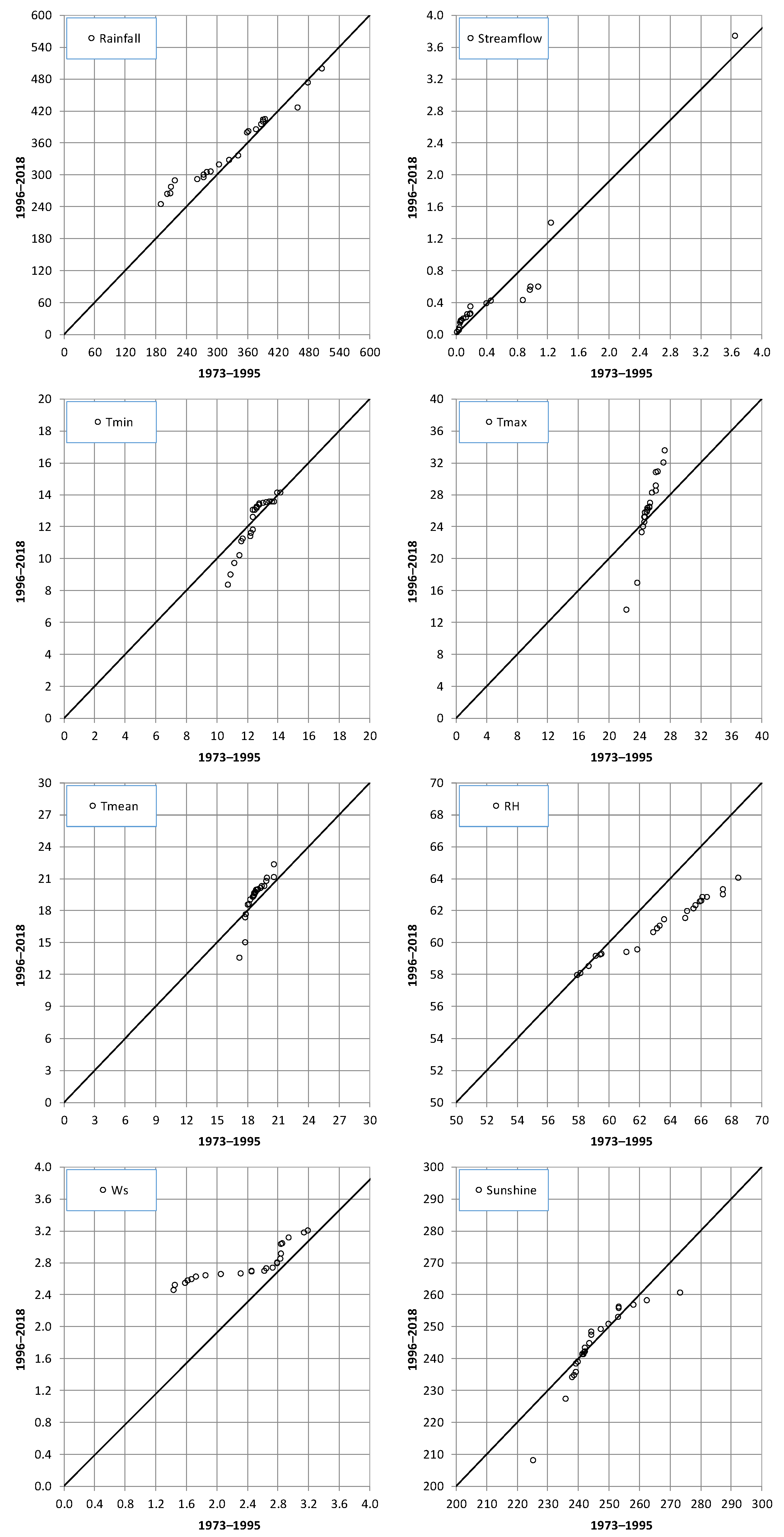
In this section, the results of the trend analysis performed at annual and monthly scales are presented and discussed. As regards rainfall, the average rain height for the basin was detected by using the Thiessen polygon method. The results of the trend analysis on monthly and annual precipitation did not show a clear tendency, with significant trends detected only in November (about +6.2 mm/10 years) and August (about −0.15 mm/10 years) (Table 1).
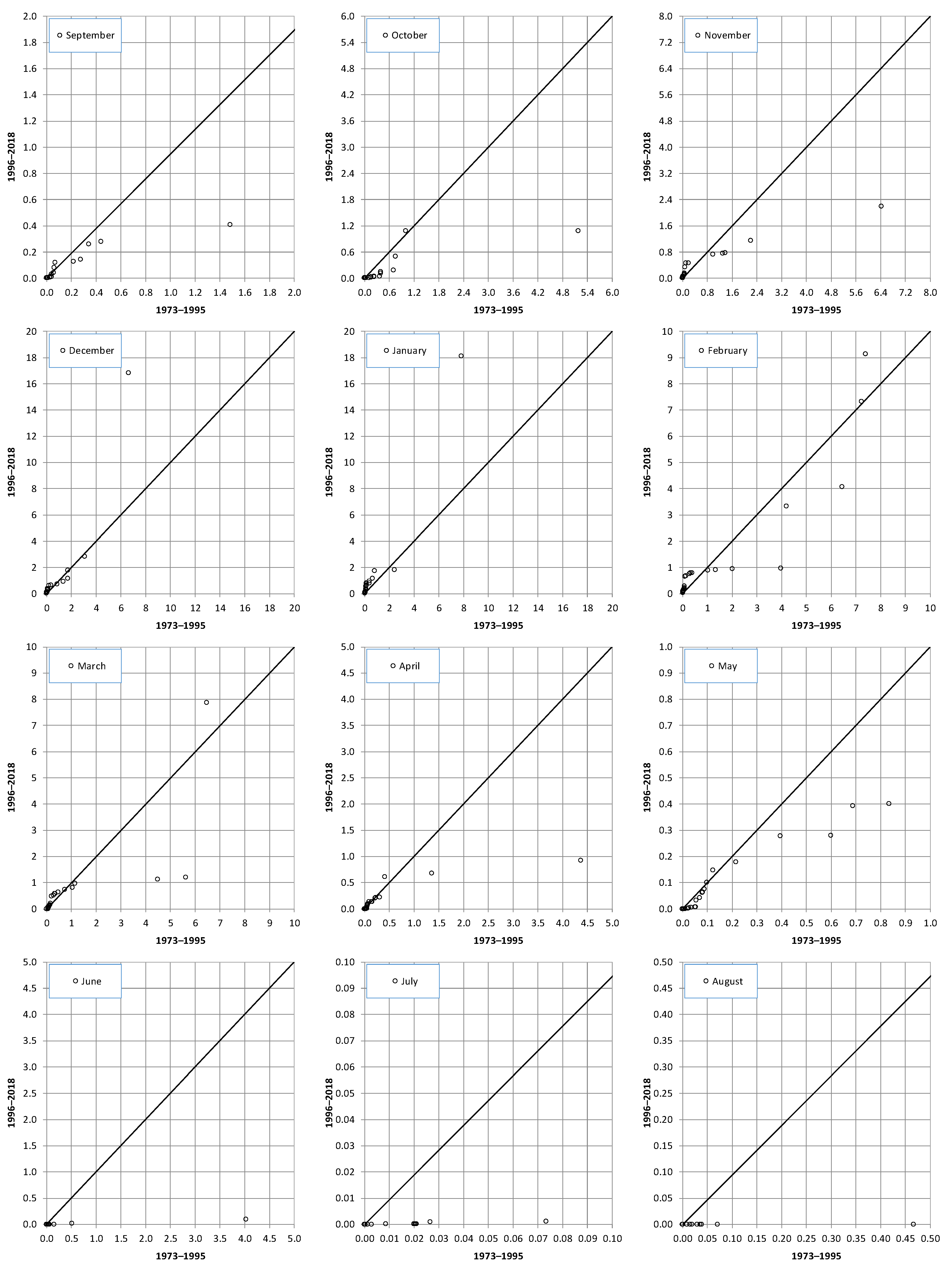
The lack of a trend of the annual rainfall and the positive trend in November were confirmed by the ITA approach (Figure 2 and Figure 3). On the contrary, the negative trend detected in August was not identified using the ITA. The latter, instead, revealed a trend of the highest values in February (negative) and July (positive).
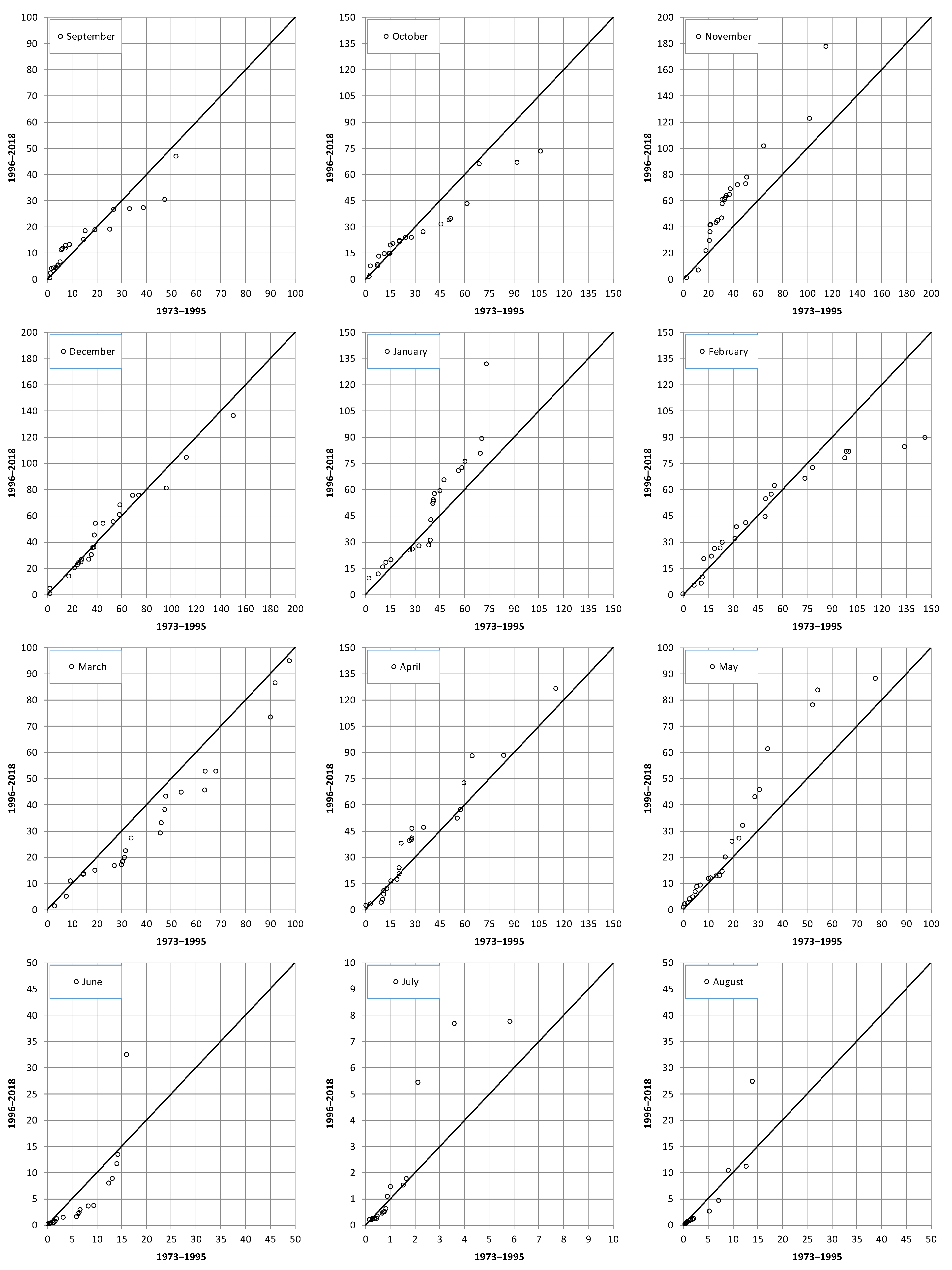
Differently from rainfall, the streamflow values evidenced negative trends in the summer–autumn period (June, July, August, September, October), although with low magnitudes (Table 1). The application of the ITA method to the annual (Figure 2) and monthly (Figure 4) streamflow values in this case study is particularly important, because it allows us to identify some years that can be classified as “outliers” influencing the results of the trend analysis. These values can be easily detected from Figure 4 and correspond to 1995 (extremely negative value) and 2005 (extremely positive value).
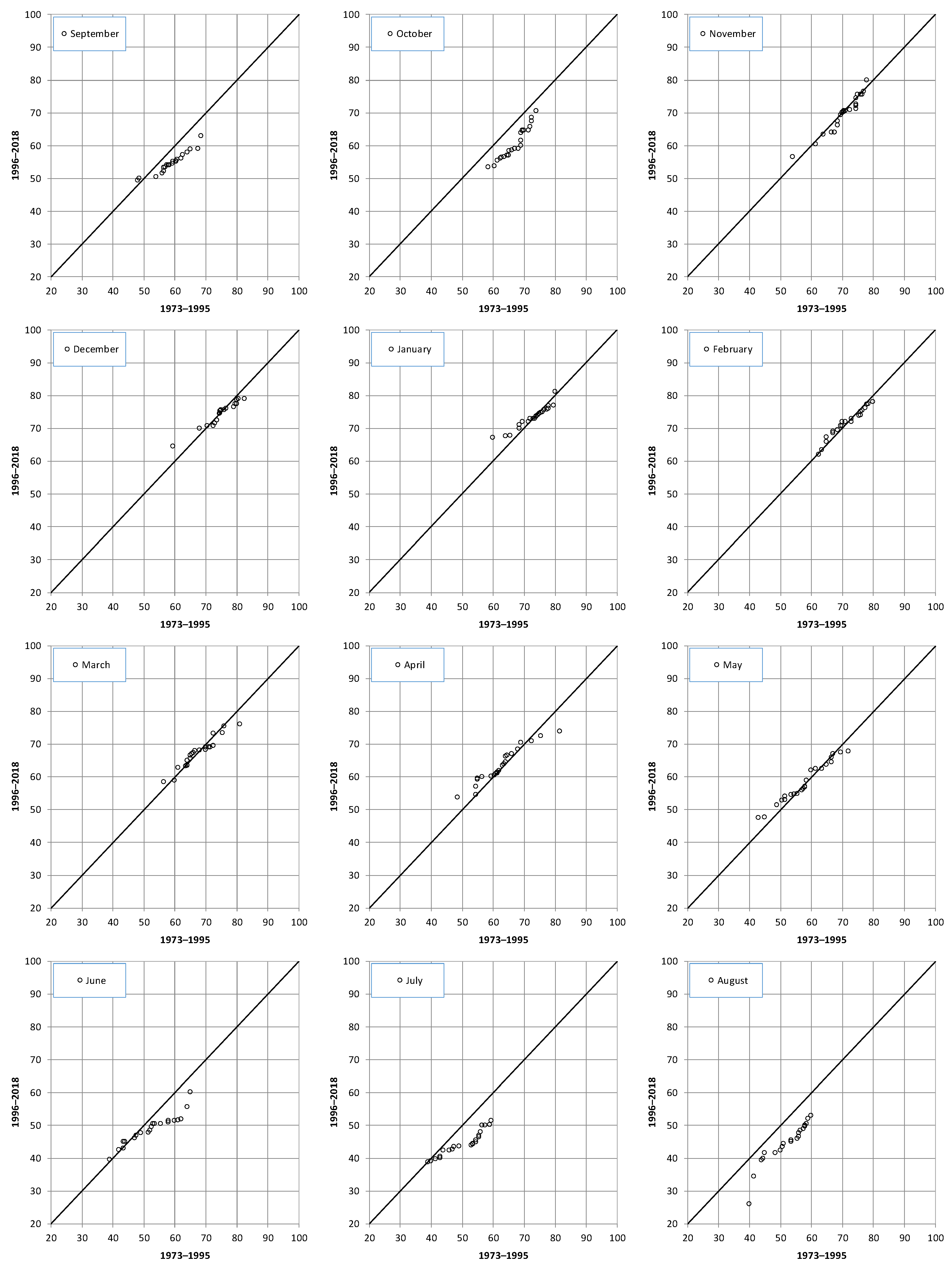
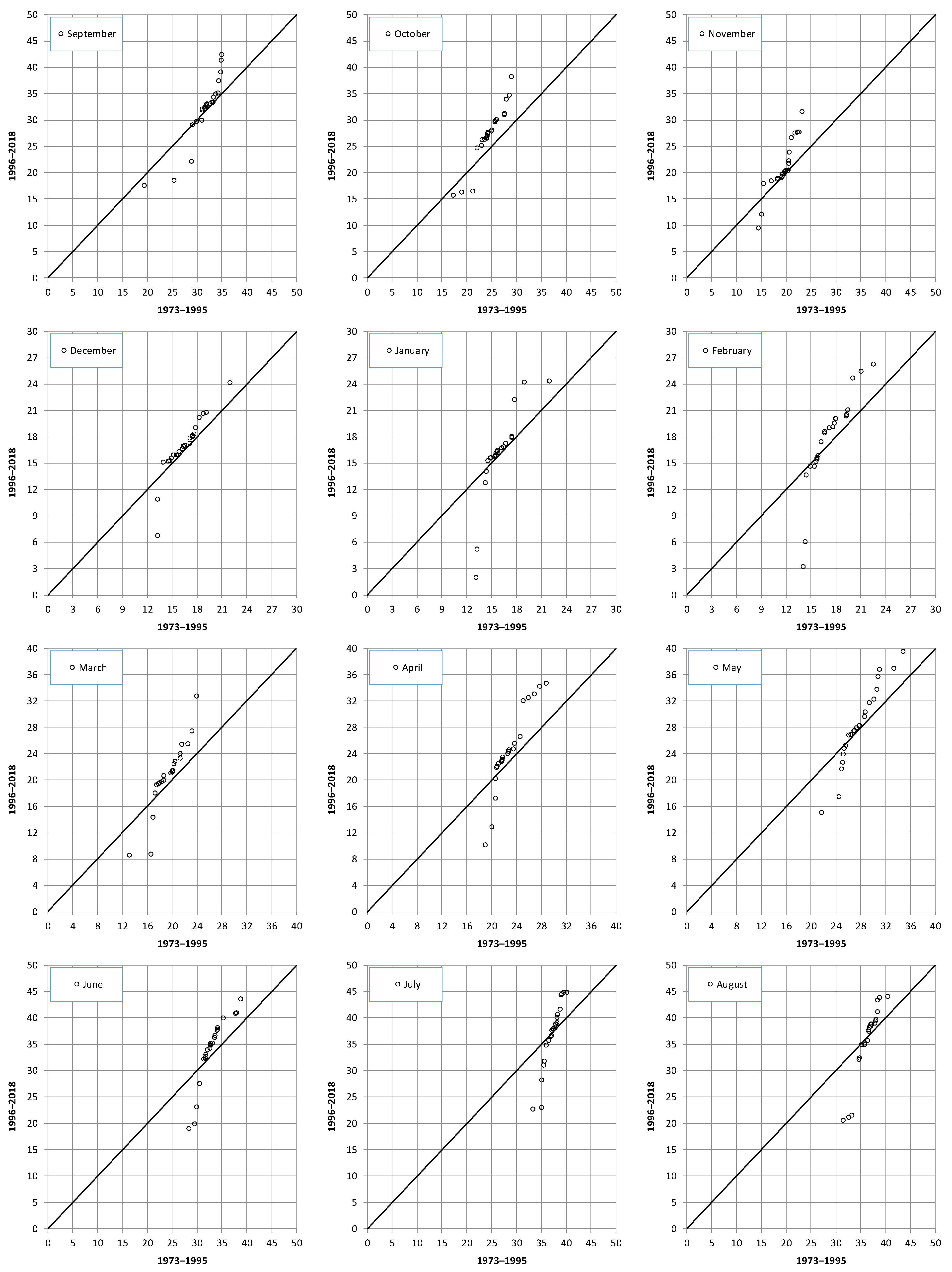
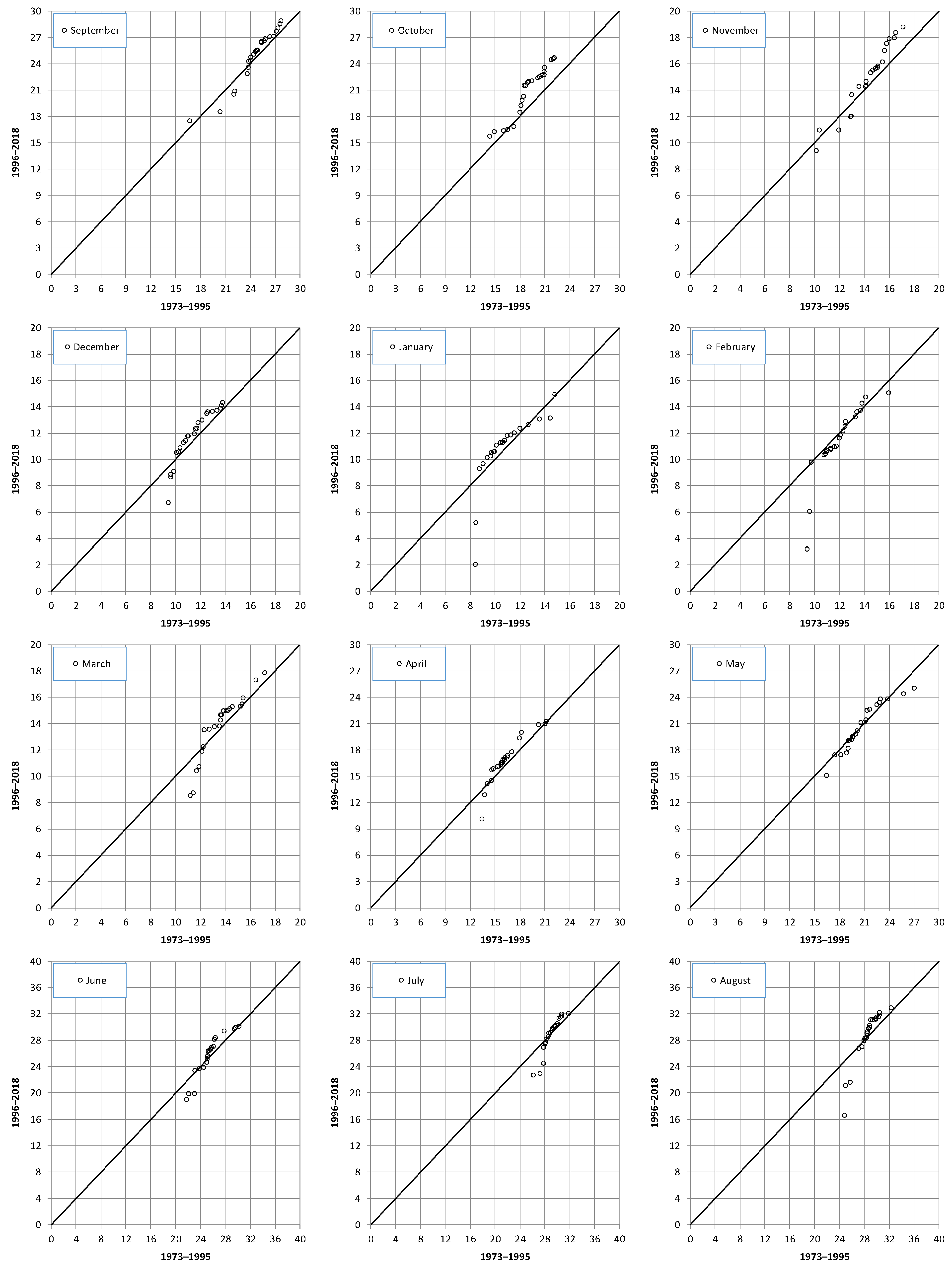
As regards temperatures, the minimum values showed increasing tendencies in August (+0.5 °C/10 years) and October (+0.6 °C/10 years), while an opposite trend was detected in February (−0.6 °C/10 years) (Table 1). Both the lack of a significant trend at an annual scale (Figure 2) and the relevant results obtained at a monthly scale (Figure 5) were confirmed by the ITA method, especially for October. At the same time, the ITA method showed a reduction of the lowest minimum temperature values in different months, e.g., March and May (Figure 5).
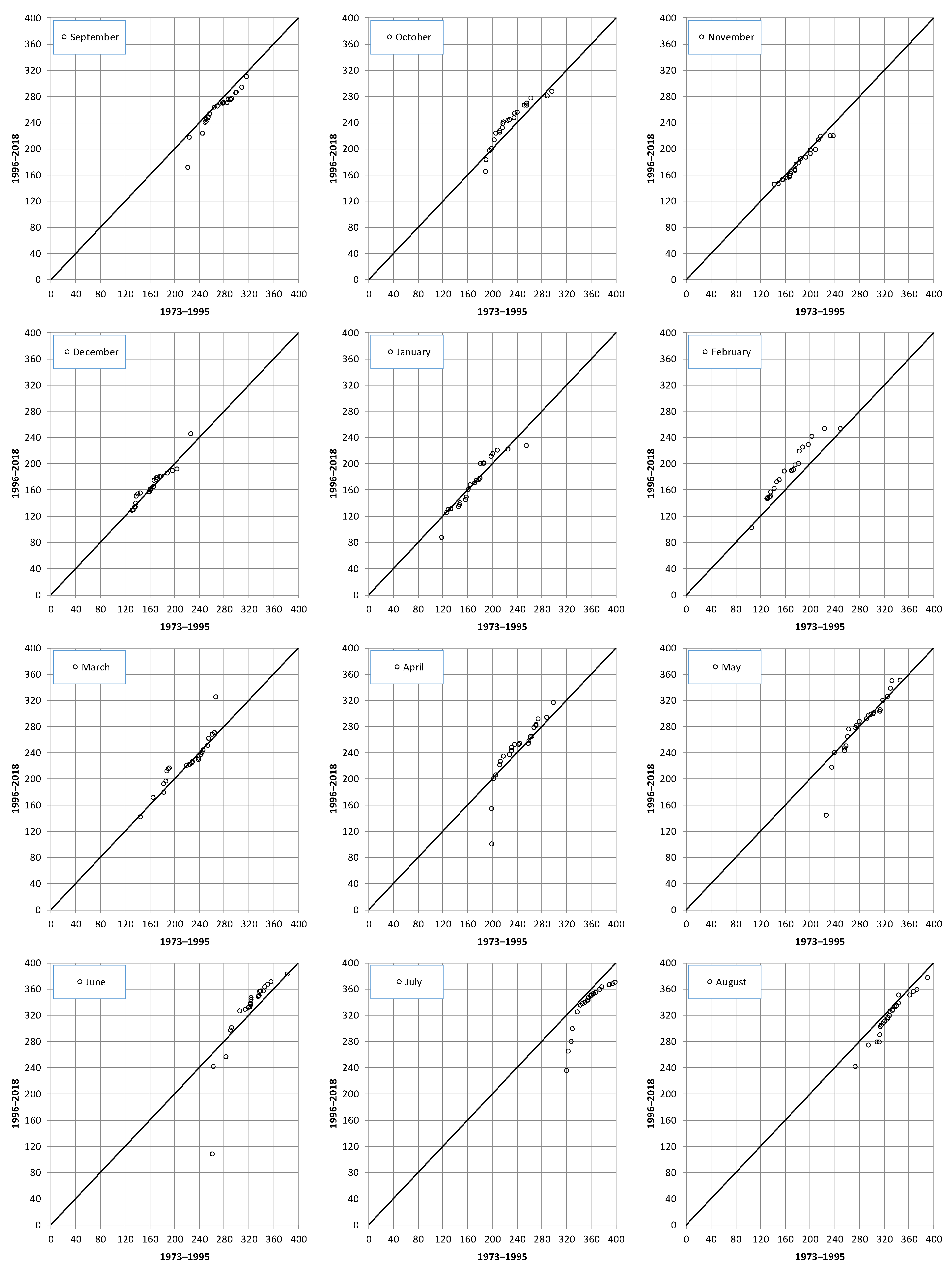
The average and the maximum temperatures evidenced similar trend results, with positive values detected at an annual scale, in April and October (Table 1). This positive behavior at an annual scale was confirmed by the ITA method (Figure 2), especially for the highest values of the maximum temperature. As regards the monthly scale, the ITA method evidenced a positive trend of the highest values in almost all the months (Figure 6). Conversely, no particular behaviors were detected for the average temperatures (Figure 7).
Considering the Relative Humidity (RH), a marked decrease was identified at an annual scale (about −1%/10 years) and in the summer–autumn period, from June to October, with a maximum reduction of about 3%/10 years in July and October (Table 1). This marked reduction in the RH values was confirmed by the ITA method, both for the annual (Figure 2) and for the monthly scale (Figure 8).
An opposite trend behavior from the RH was evaluated for the Wind Speed (Ws), with positive trend identified in several months (with the exception of April, June, and July) but not at an annual scale (Table 1). Also in this case, the positive tendencies evaluated using non-parametric tests were confirmed by the ITA method, which evidenced a more marked reduction in the lower values than in the higher values for the annual (Figure 2) and the monthly scales (Figure 9).
Finally, few increases in the sunshine values were detected in February and April (Table 1) even though, looking at the ITA diagrams, the sunshine data seems to be distributed close to the 45° line (Figure 2 and Figure 10).

4. Discussion

North Africa relies heavily on several hydro-meteorological variables for its agricultural practices, especially rainfall and runoff. The success or failure of climate resilience and adaptation is closely tied to the changing patterns of these variables. Algeria, like its African and Mediterranean counterparts, faces increased susceptibility to the multifaceted impacts of climate change, jeopardizing its economic and social progress. Predominantly arid or semi-arid, the nation is grappling with increasing desertification and land degradation. With the exception of a thin coastal strip, which receives more than 400 mm of rainfall per year, large areas of the country are experiencing arid conditions. Climate change has caused a significant decrease in rainfall of more than 30 percent in recent decades, exacerbating desertification through prolonged drought cycles. In addition, the specter of extreme weather events looms, as evidenced by the National Meteorological Office’s documentation of intensified rainfall, floods, droughts, heat waves, and sandstorms. Every summer, vast areas of forest succumb to wildfires, underscoring the terrible ecological toll imposed by climate fluctuations. Within this context, accurate knowledge about hydro-meteorological factors is crucial for decision makers involved in different sectors, such as effective crop planning, water resource management [24], energy consumption forecasting [33], etc. Unfortunately, obtaining detailed and comprehensive data for analyzing these trends poses a significant challenge, and for this reason, the trend analysis performed in this study on eight different hydro-meteorological variables is especially important, since past studies in North Africa were mainly focused on rainfall, streamflow, and temperature only. As regards rainfall, the results of this study partially agree with preceding studies evidencing a rainfall reduction, especially at the annual scale [3]. The findings from the trend analysis of the streamflow data align with previous studies conducted in the Mediterranean basin, specifically North Africa. Extensive hydrological modeling has indicated a future decrease in water resources [34], primarily attributed to the projected decline in rainfall across the southern Mediterranean region [35]. A recent study by Tramblay et al. [36] analyzed the influence of climate change on water resources in 46 North African basins. The research showed a future decline in surface water resources due to a combination of reduced precipitation and increased evapotranspiration. Finally, with respect to temperature data, although previous planetary-scale investigations on maximum and minimum temperatures showed an increase in the minimum values rather than the maximum ones [37], the results of this study evidenced an opposite behavior, thus confirming those achieved by previous research performed in Italy [38].
Figure 8. Results of the ITA methods applied to the monthly relative humidity values.
Hydrology 11 00077 g008
Figure 9. Results of the ITA methods applied to the monthly wind speed values.
Hydrology 11 00077 g009
Figure 10. Results of the ITA methods applied to the monthly insolation values.
Hydrology 11 00077 g010

5. Conclusions

The results of the trend analysis display changes in hydro-meteorological data that may be used to manage water resources in the future. In particular, while precipitation did not show any particular trend, a marked negative trend was detected in the runoff values at the different timescales. These changes in the Wadi Ouahrane discharges can be attributed to climate change but also to the anthropogenic activity in the basin, such as the significant changes during the study period in land use/land cover for agricultural purposes and the location of several hillside basins upstream of the hydrometric station. Moreover, an increase in the mean and maximum temperature values was identified. Finally, the trend analysis evidenced a negative trend in the relative humidity, an opposite trend in the wind speed, and no trends in the sunshine values. The findings of this study not only increase our understanding of the changing climate dynamics within the basin but also provide valuable insights for policymakers, water resource managers, and other stakeholders involved in climate change adaptation and sustainable development in the region. By identifying the prevailing trends in hydro-meteorological variables, this research study can contribute to the formulation of effective strategies to mitigate the potential impacts of climate change in various sectors.

Author Contributions

Conceptualization, M.A. and T.C.; methodology, M.A. and T.C.; software, T.C. and A.B.; validation, M.A., T.C., A.W. and A.C.; formal analysis, T.C. and A.C.; investigation, M.A.; resources, M.A.; data curation, M.A. and T.C.; writing—original draft preparation, M.A. and T.C.; writing—review and editing, M.A., T.C., A.C. and A.W.; visualization, M.A. and T.C.; supervision, M.A., T.C. and A.C.; project administration, M.A.; All authors have read and agreed to the published version of the manuscript.

Funding

This research received no external funding.

Data Availability Statement

Data will provided upon request.

Acknowledgments

We thank the National Agency of the Water Resources (ANRH) for the collected data and the General Directorate of Scientific Research and Technological Development of Algeria (DGRSDT).

Conflicts of Interest

The authors declare no conflicts of interest.

References

  1. Paliaga, G.; Parodi, A. Geo-Hydrological Events and Temporal Trends in CAPE and TCWV over the Main Cities Facing the Mediterranean Sea in the Period 1979–2018. Atmosphere 2022, 13, 89. [Google Scholar] [CrossRef]
  2. Giorgi, F. Climate Change Hot-Spots. Geophys. Res. Lett. 2006, 33, L08707. [Google Scholar] [CrossRef]
  3. Caloiero, T.; Caloiero, P.; Frustaci, F. Long-term precipitation trend analysis in Europe and in the Mediterranean basin. Water Environ. J. 2018, 32, 433–445. [Google Scholar] [CrossRef]
  4. IPCC. Summary for Policymakers. In Climate Change 2021: The Physical Science Basis. Contribution of Working Group I to the Sixth Assessment Report of the Intergovernmental Panel on Climate Change; Masson-Delmotte, V., Zhai, P., Pirani, A., Connors, S.L., Péan, C., Berger, S., Caud, N., Chen, Y., Goldfarb, L., Gomis, M.I., et al., Eds.; Cambridge University Press: Cambridge, UK; New York, NY, USA, 2021; pp. 3–32. [Google Scholar]
  5. Castellanos, M.; GarcíaIsidro, M.A.; Pérez, I.A.; Sánchez, M.L.; Pardo, N.; Fernández-Duque, B. Measuring temperature trends in the Mediterranean basin. J. Atmos. Sol. Terr. Phys. 2021, 222, 105713. [Google Scholar] [CrossRef]
  6. Luppichini, M.; Bini, M.; Barsanti, M.; Giannecchini, R.; Zanchetta, G. Seasonal rainfall trends of a key Mediterranean area in relation to large-scale atmospheric circulation: How does current global change affect the rainfall regime? J. Hydrol. 2022, 612, 128233. [Google Scholar] [CrossRef]
  7. Onyutha, C. Identification of sub-trends from hydro-meteorological series. Stoch. Environ. Res. Risk Assess 2015, 30, 189–205. [Google Scholar] [CrossRef]
  8. Longobardi, A.; Villani, P. Trend analysis of annual and seasonal rainfall time series in the Mediterranean area. Int. J. Climatol. 2010, 30, 1538–1546. [Google Scholar] [CrossRef]
  9. Maheras, P.; Tolika, K.; Anagnostopoulou, C.; Vafiadis, M.; Patrikas, I.; Flocas, H. On the relationships between circulation types and changes in rainfall variability in Greece. Int. J. Climatol. 2004, 24, 1695–1712. [Google Scholar] [CrossRef]
  10. Altin, T.B.; Barak, B. Changes and trends in total yearly precipitation of the Antalya District, Turkey. Procedia Soc. Behav. Sci. 2014, 120, 586–599. [Google Scholar] [CrossRef]
  11. Shohami, D.; Dayan, U.; Morin, E. Warming and drying of the eastern Mediterranean: Additional evidence from trend analysis. J. Geophys. Res. 2011, 116, D22101. [Google Scholar] [CrossRef]
  12. Ziv, B.; Saaroni, H.; Pargament, R.; Harpaz, T.; Alpert, P. Trends in rainfall regime over Israel, 1975–2010, and their relationship to large-scale variability. Reg. Environ. Chang. 2014, 14, 1751–1764. [Google Scholar] [CrossRef]
  13. Zittis, G. Observed rainfall trends and precipitation uncertainty in the vicinity of the Mediterranean, Middle East and North Africa. Theor. Appl. Climatol. 2018, 134, 1207–1230. [Google Scholar] [CrossRef]
  14. Donat, M.G.; Peterson, T.C.; Brunet, M.; King, A.D.; Almazroui, M.; Kolli, R.K.; Boucherf, D.; Al-Mulla, A.Y.; Nour, A.Y.; Aly, A.A.; et al. Changes in extreme temperature and precipitation in the Arab region: Long-term trends and variability related to ENSO and NAO. Int. J. Climatol. 2014, 34, 581–592. [Google Scholar] [CrossRef]
  15. Meddi, M.; Hubert, P. Impact de la modification du régime pluviométrique sur les ressources en eau du Nord–Ouest de l’Algérie. In Hydrology of the Mediterranean and Semiarid Regions; Servat Najem, E., Leduc, W., Shakeel, E.A., Eds.; IAHS Publishing: Wallingford, UK, 2003; pp. 229–235. [Google Scholar]
  16. Goubanova, K.; Li, L. Extremes in temperature and precipitation around the Mediterranean basin in an ensemble of future climate scenario simulations. Glob. Planet Chang. 2007, 57, 27–42. [Google Scholar] [CrossRef]
  17. Tramblay, Y.; El Adlouni, S.; Servat, E. Trends and variability in extreme precipitation indices over Maghreb countries. Nat. Hazards Earth Syst. Sci. 2013, 13, 3235–3248. [Google Scholar] [CrossRef]
  18. Elmeddahi, Y.; Issaadi, A.; Mahmoudi, H.; Tahar Abbes, M.; Goossen, M.F.A. Effect of climate change on water resources of the Algerian Middle Cheliff basin. Desalination Water Treat. 2014, 52, 2073–2081. [Google Scholar] [CrossRef]
  19. Ragab, R.; Prudhomme, C. Climate change and water resources management in arid and semi-arid regions: Prospective and challenges for the 21st century. Biosyst. Eng. 2002, 81, 3–34. [Google Scholar] [CrossRef]
  20. Giorgi, F.; Lionello, P. Climate change projections for the Mediterranean region. Glob. Planet Chang. 2008, 63, 90–104. [Google Scholar] [CrossRef]
  21. Achite, M.; Ceribasi, G.; Ceyhunlu, A.I.; Wałęga, A.; Caloiero, T. The Innovative Polygon Trend Analysis (IPTA) as a Simple Qualitative Method to Detect Changes in Environment—Example Detecting Trends of the Total Monthly Precipitation in Semiarid Area. Sustainability 2021, 13, 12674. [Google Scholar] [CrossRef]
  22. Achite, M.; Caloiero, T.; Wałęga, A.; Krakauer, N.; Hartani, T. Analysis of the Spatiotemporal Annual Rainfall Variability in the Wadi Cheliff Basin (Algeria) over the Period 1970 to 2018. Water 2021, 13, 1477. [Google Scholar] [CrossRef]
  23. Achite, M.; Bazrafshan, O.; Wałęga, A.; Azhdari, Z.; Krakauer, N.; Caloiero, T. Meteorological and Hydrological Drought Risk Assessment Using Multi-Dimensional Copulas in the Wadi Ouahrane Basin in Algeria. Water 2022, 14, 653. [Google Scholar] [CrossRef]
  24. Achite, M.; Caloiero, T.; Toubal, A.K. Rainfall and Runoff Trend Analysis in the Wadi Mina Basin (Northern Algeria) Using Non-Parametric Tests and the ITA Method. Sustainability 2022, 14, 9892. [Google Scholar] [CrossRef]
  25. Achite, M.; Ceribasi, G.; Wałęga, A.; Ceyhunlu, A.I.; Elshaboury, N.; Krakauer, N.; Hartani, T.; Caloiero, T.; Gul, S. Analysis of monthly average precipitation of Wadi Ouahrane basin in Algeria by using the ITRA, ITPAM, and TPS methods. Environ. Monit. Assess. 2023, 195, 606. [Google Scholar] [CrossRef] [PubMed]
  26. Sen, P.K. Estimates of the Regression Coefficient Based on Kendall’s Tau. J. Am. Stat. Assoc. 1968, 63, 1379–1389. [Google Scholar] [CrossRef]
  27. Mann, H.B. Nonparametric Tests Against Trend. Econometrica 1945, 13, 245–259. [Google Scholar] [CrossRef]
  28. Kendall, M.G. Rank Correlation Methods; Hafner Publishing Company: New York, NY, USA, 1962. [Google Scholar]
  29. Şen, Z. Innovative Trend Analysis Methodology. J. Hydrol. Eng. 2012, 17, 1042–1046. [Google Scholar] [CrossRef]
  30. Caloiero, T.; Coscarelli, R.; Ferrari, E. Assessment of seasonal and annual rainfall trend in Calabria (southern Italy) with the ITA method. J. Hydroinformatics 2019, 22, 738–748. [Google Scholar] [CrossRef]
  31. Kisi, O. An innovative method for trend analysis of monthly pan evaporations. J. Hydrol. 2015, 527, 1123–1129. [Google Scholar] [CrossRef]
  32. Wu, H.; Qian, H. Innovative trend analysis of annual and seasonal rainfall and extreme values in Shaanxi, China, since the 1950s. Int. J. Climatol. 2017, 37, 2582–2592. [Google Scholar] [CrossRef]
  33. Giunta, G.; Vernazza, R.; Salerno, R.; Ceppi, A.; Ercolani, G.; Mancini, M. Hourly weather forecasts for gas turbine power generation. Meteorol. Z. 2017, 26, 307–317. [Google Scholar] [CrossRef]
  34. Prudhomme, C.; Giuntoli, I.; Robinson, E.L.; Clark, D.B.; Arnell, N.W.; Dankers, R.; Fekete, B.M.; Franssen, W.; Gerten, D.; Gosling, S.N.; et al. Hydrological droughts in the 21st century, hotspots and uncertainties from a global multimodel ensemble experiment. Proc. Natl. Acad. Sci. USA 2014, 111, 3262–3267. [Google Scholar] [CrossRef] [PubMed]
  35. Lionello, P.; Scarascia, L. The relation between climate change in the Mediterranean region and global warming. Reg. Environ. Chang. 2018, 18, 1481–1493. [Google Scholar] [CrossRef]
  36. Tramblay, Y.; Jarlan, L.; Hanich, L.; Somot, S. Future Scenarios of Surface Water Resources Availability in North African Dams. Water Resour. Manag. 2018, 32, 1291–1306. [Google Scholar] [CrossRef]
  37. Easterling, D.R.; Horton, B.; Jones, P.D.; Peterson, T.C.; Karl, T.R.; Parker, D.E.; Salinger, M.J.; Razuvayev, V.; Plummer, N.; Jamason, P.; et al. Maximum and minimum temperature trends for the globe. Science 1997, 277, 364–367. [Google Scholar] [CrossRef]
  38. Caloiero, T.; Guagliardi, I. Climate change assessment: Seasonal and annual temperature analysis trends in the Sardinia region (Italy). Arab. J. Geosci. 2021, 14, 2149. [Google Scholar] [CrossRef]
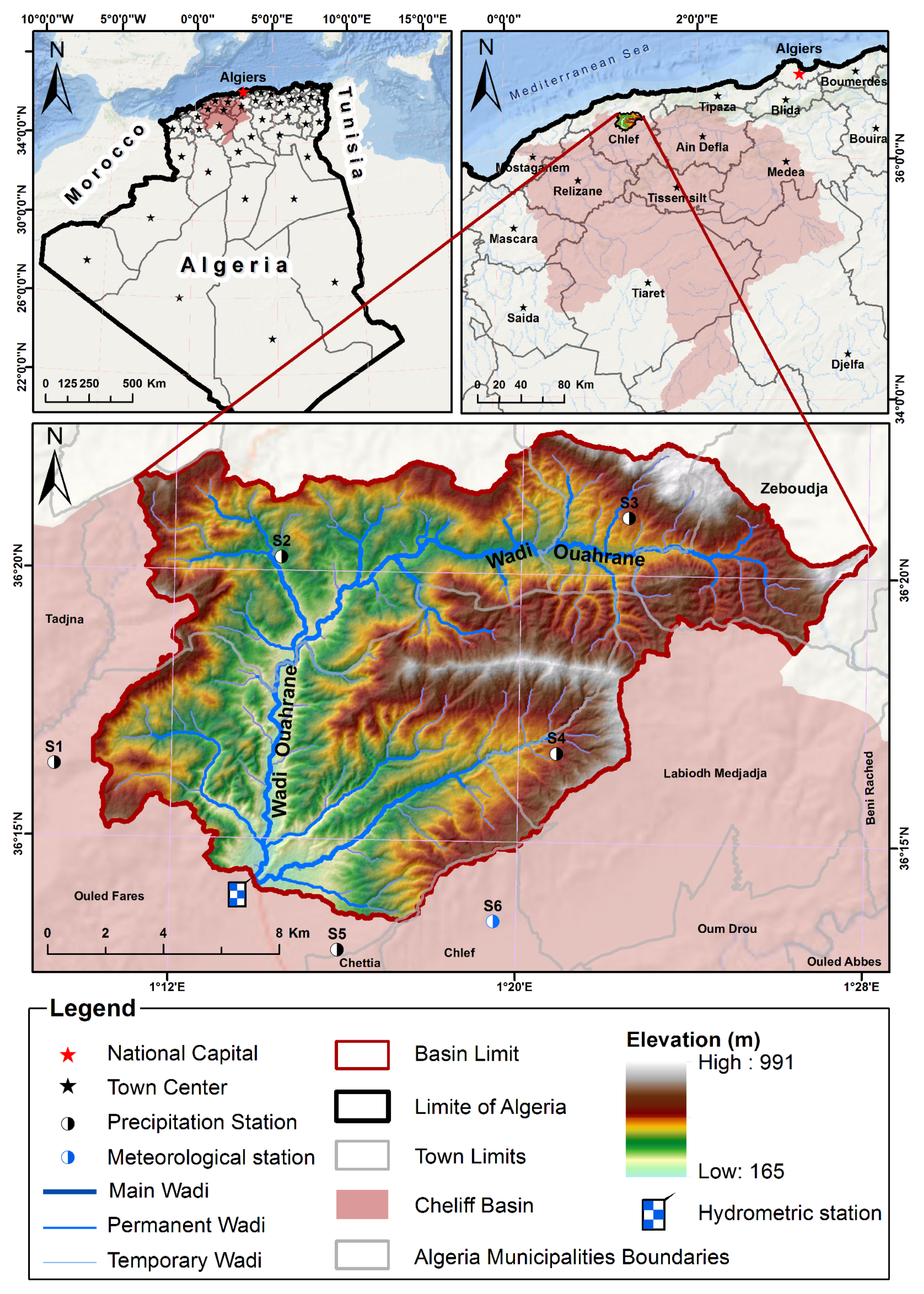
Figure 1. The Wadi Ouahrane basin.
Hydrology 11 00077 g001
Figure 2. Results of the ITA methods applied to the annual values.
Hydrology 11 00077 g002
Figure 3. Results of the ITA methods applied to the monthly rainfall values.
Hydrology 11 00077 g003
Figure 4. Results of the ITA methods applied to the monthly streamflow values.
Hydrology 11 00077 g004
Figure 5. Results of the ITA methods applied to the monthly minimum temperature values.
Hydrology 11 00077 g005
Figure 6. Results of the ITA methods applied to the monthly maximum temperature values.
Hydrology 11 00077 g006
Figure 7. Results of the ITA methods applied to the monthly average temperature values.
Hydrology 11 00077 g007
Table 1. Results of the trend analysis for the different variables expressed as trend/10 years (rainfall: mm/10 years; runoff: (m3/s)/10 years; temperature: °C/10 years; relative humidity: %/10 years; wind speed: (m/s)/10 years; insolation: hours/10 years).
PeriodRainfallRunoffMinimum TemperatureMaximum TemperatureAverage TemperatureRelative HumidityWind SpeedInsolation
September−0.337−0.0050.1160.4680.370−1.5910.200−4.172
October−1.490−0.0110.6001.3570.772−2.8850.0954.167
November6.2630.0000.0250.3640.400−0.7500.250−3.958
December−2.0610.0170.1260.3680.238−0.3380.1944.737
January2.5810.0450.0000.1110.018−0.4060.2002.091
February−1.995−0.012−0.6110.533−0.088−0.0730.2827.375
March−2.685−0.0250.0710.8280.3090.0000.2860.185
April−1.242−0.0110.0410.9410.422−0.3260.1337.375
May−0.207−0.007−0.1150.7630.174−0.9090.1332.714
June−0.175−0.0010.0481.1110.289−1.7860.0914.583
July0.001−0.0040.1670.3330.237−2.8100.050−4.083
August−0.153−0.0040.5310.5500.510−2.6390.1430.476
Annual−5.832−0.0050.0450.6770.418−1.1820.1070.141
Bold values mean statistically significant results (SL = 95%).
Disclaimer/Publisher’s Note: The statements, opinions and data contained in all publications are solely those of the individual author(s) and contributor(s) and not of MDPI and/or the editor(s). MDPI and/or the editor(s) disclaim responsibility for any injury to people or property resulting from any ideas, methods, instructions or products referred to in the content.