Article

Catchment-Scale Challenges for Water Resources Management: Assessing ‘Reasonable’ Peak Needs for Irrigated Agriculture in a Humid Climate

Centre for Water, Environment and Development, Cranfield University, Bedford MK43 0AL, UK
*
Author to whom correspondence should be addressed.
Hydrology 2024, 11(3), 33; https://doi.org/10.3390/hydrology11030033
Submission received: 12 December 2023 / Revised: 8 February 2024 / Accepted: 23 February 2024 / Published: 27 February 2024
(This article belongs to the Topic Hydrology and Water Resources Management)

Abstract

:
Rising demands and competition for water resources within all sectors are placing increasing pressure on the environment. Almost all direct abstractions in England require a licence (permit) from the regulatory authority, the Environment Agency. Assessing and setting ‘reasonable’ peak quantities of water that can be legally abstracted in an environmentally sustainable manner is central to the whole licence determination process. To protect environmental flows and other abstractors within each catchment, the regulatory authority needs to be able to set sensible limits in the licence conditions, including total seasonal volumes and peak rates of water use, particularly for abstractions from hydrologically sensitive surface water sources. This paper describes the development of a methodology to assess the ‘reasonable’ peak rates of water use for agricultural irrigation in support of catchment water resources management and planning. A daily time step water balance model was used to simulate peak monthly and daily water requirements for irrigation using long-term historical weather records for agroclimatically contrasting sites. The model-simulated outputs were then compared against observed data from selected case study farms, and against data reported in a national water abstraction database. Guidelines were then developed for setting peak monthly, daily, hourly, and absolute abstraction rates for irrigation, taking into account the environmental sensitivity of different types of water source. The application of the procedure and its relevance in other countries where catchment water resources are under intense pressure from agriculture are described.

1. Introduction

Water withdrawals (or abstractions) for agricultural irrigation in England constitute a small proportion of total water use nationally, but it is a consumptive use, peaking in the summer months in dry years when water resources are scarcest. The volume of water licensed and abstracted for irrigation has increased substantially over the last 45 years (Figure 1), largely in response to increasing demands for high-quality fruit and vegetables from retailers and processors, although since 1998, there has been a moratorium on new licenses. On average, approximately only a third (c30%) of the total volume of water licensed for irrigation is actually abstracted (which increases to c50% in dry summers), but in many catchments, particularly in eastern England, the volumes of water licensed for abstraction are now considered to be environmentally unsustainable [1,2]. Nationally, the need for a more rational and flexible approach to allocating water has been identified [3], with abstraction reforms now underway to reduce allocated volumes and to limit peak abstraction rates [2]). This requirement is consistent with various European Directives relating to the Conservation of Wild Birds (1979/409/EC), Natural Habitats, Wild Fauna and Flora (1992/43/EC), and the Water Framework Directive (2000/60/EC), which have been implemented to provide greater environmental protection and to control current and future water abstractions.
Almost all abstractions from surface and groundwater sources in England require a licence from the regulatory authority, the Environment Agency (EA). In 2018, there were 18,193 abstraction licences in force of which nearly half (49%) were for agricultural irrigation [4]. Although each application is judged on its own merits, the EA has a duty to take into account the ‘reasonableness’ of all licence applications. Assessing and setting ‘reasonable’ quantities of water allowed for abstraction is, therefore, central to the whole licence determination process. Previous research provided the EA with guidance on how to assess individual seasonal (annual) licensed volumes for irrigation [5], taking into account farm location, the mix of crop types being irrigated, local soils and agroclimate variability and management practices, including application methods and irrigation efficiency. However, to protect the environment and other abstractors, the regulatory authority also needs to set sensible limits in the licence conditions that include peak rates of water use, particularly for abstractions from surface water sources, which provide important environmental flows for aquatic dependent ecosystems.
Setting peak rates of abstraction also has important hydrological and water resource implications because the timing and duration of irrigation varies markedly between crops. For example, setting too high a peak rate risks allowing excessive abstraction, particularly at times of low river flow, and hence limits the regulatory authority’s ability to protect the environment and/or derogating water that has been licensed to other users. Setting too low a peak rate unnecessarily restricts abstractors and does not make best use of the available water resources, particularly during high flows when filling on-farm storage reservoirs might be a priority. It also restricts an irrigator’s ability to conserve water, reduce energy costs, and utilise staff effectively. Hence, there is a clear need to set limits on peak rates of abstraction over varying periods, including peak monthly, daily, hourly, or even on an absolute rate of abstraction. There are no known studies internationally which have assessed the peak rates of irrigation abstraction, taking into account different water sources although various studies have assessed the reliability of different water supplies for agriculture from a supply-side, rather than a demand-side perspective (e.g., [6]). In the context of reviewing catchment water resources planning and allocation for agricultural irrigation, this paper describes the development of a methodology to set ‘reasonable’ values for peak rates of water use that take into account both the protection of the resource (environment) and the abstractor’s reasonable needs. The methodology was developed for application in England, but in countries where irrigation is supplemental, and where appropriate data are available, it is equally applicable. A brief outline of the methodology, the application of the procedure and its methodological limitations are described.

2. Materials and Methods

A three-stage methodology was developed. Firstly, an irrigation scheduling water balance model was used to simulate the peak monthly-to-annual and the peak daily-to-annual ratios. Both these ratios are critically important for water regulatory agencies to ensure that the allowable rates of water withdrawal do not negatively impact on or derogate other abstractors relying on the same water source, including the need to maintain environmental flows. These modelled outputs were then compared against observed data from a number of case study farms and from historical abstraction data held within a national water archive. Finally, the results were combined to produce guidelines for setting various peak rates of abstraction. A description of each stage is given below.

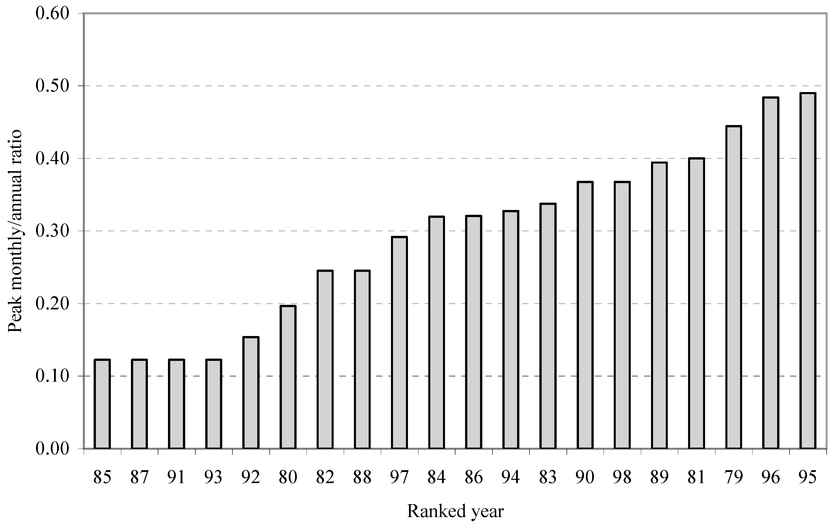
2.1. Modelling Peak Monthly-to-Annual Ratios

The peak monthly irrigation requirements for a given site are determined by the peak crop water use in the middle of hot dry summers. There is some buffering over periods ranging from a few days to several weeks due to available soil moisture storage depending on the available water capacity and the texture of local soil types and crop rooting depths. The factors involved in assessing peak monthly rates are, thus, similar to those involved in determining seasonal (annual) irrigation requirements and are a function of crop type, climate, soil texture, and irrigation management practices. Crops with high monthly peaks tend to be those with high annual irrigation needs. It is, therefore, sensible to set peak rates as a proportion of the total irrigation need for a defined probability or return period, usually termed the ‘design’ dry year. In this study, the modelled irrigation needs, and peak abstraction rates were defined for a ‘design’ dry year with an 80% probability of non-exceedance.
Peak monthly-to-annual ratios were estimated using an irrigation scheduling water balance model, termed Irrigation Water Requirements (IWR), which was originally developed by [7]. It estimates the daily soil water balance for a selected crop and soil type, working from daily rainfall (P) and reference evapotranspiration (ETo) data. It uses a two-layer (topsoil and subsoil) soil water balance to estimate the daily soil water storage, incorporating inputs of rainfall and irrigation and outputs of crop evapotranspiration (ETcrop) and drainage. The model does not take into account possible contributions from groundwater (through upward capillary rise), but this is assumed minimal for most irrigated crops in the UK. Reference evapotranspiration is calculated using the FAO Penman–Monteith method [8] partitioned and modified to determine actual evapotranspiration and soil evaporation based on the degree of crop cover, stage of growth, and soil water status. Actual soil evaporation was calculated in a two-stage process based on the method of [9]. The model assumes zero runoff from rainfall, which is considered reasonable for supplemental irrigation in dry UK summers.
The model requires input data relating to crop cover development (dates of planting, full cover, and harvest) and rooting characteristics, soil water holding characteristics, and the planned irrigation schedule (defining when and how much irrigation water should be applied). In this study, three important but contrasting irrigated crops (potatoes, sugar beet, and carrots) were modelled, all assumed to be grown in a soil with a medium available water holding capacity (AWC). These crops were chosen to reflect the dominant irrigated root and vegetable crops and to account for different cropping seasons and irrigation schedules to maximise yield and for quality assurance. A description of the model input parameters (crop and soil characteristics and irrigation schedules) is described in [10]. Long-term (20-year) daily time-step historical weather data for three agroclimatically contrasting sites were used, including the following: Silsoe, Bedfordshire (Lat 0.43° W, Lon 52.00° N, altitude 68 m); Shawbury, Shropshire (Lat 2.66° W, Lon 52.79° N, altitude 72 m); and Wye, Kent (Lat 0.56° E, Lon 51.10° N, altitude 43 m). For each year of the weather records, the IWR model outputs data on the crop water use (mm), any irrigation applied (mm), and the proportional yield loss (%) due to any water stress. The model was run for each crop/site permutation. The annual irrigation needs (depths applied, mm) were statistically analysed to determine the ‘design’ dry year need (80% non-exceedance). The total irrigation need in each month and in each year was calculated and ranked. For each year, a ratio between the maximum monthly irrigation need and the ‘design’ dry year need was calculated. A worked example is shown in Table 1. The procedure was repeated for each crop-site permutation to assess the impact of different cropping calendars, irrigation schedules, and agroclimate on the peak monthly-to-annual ratios.

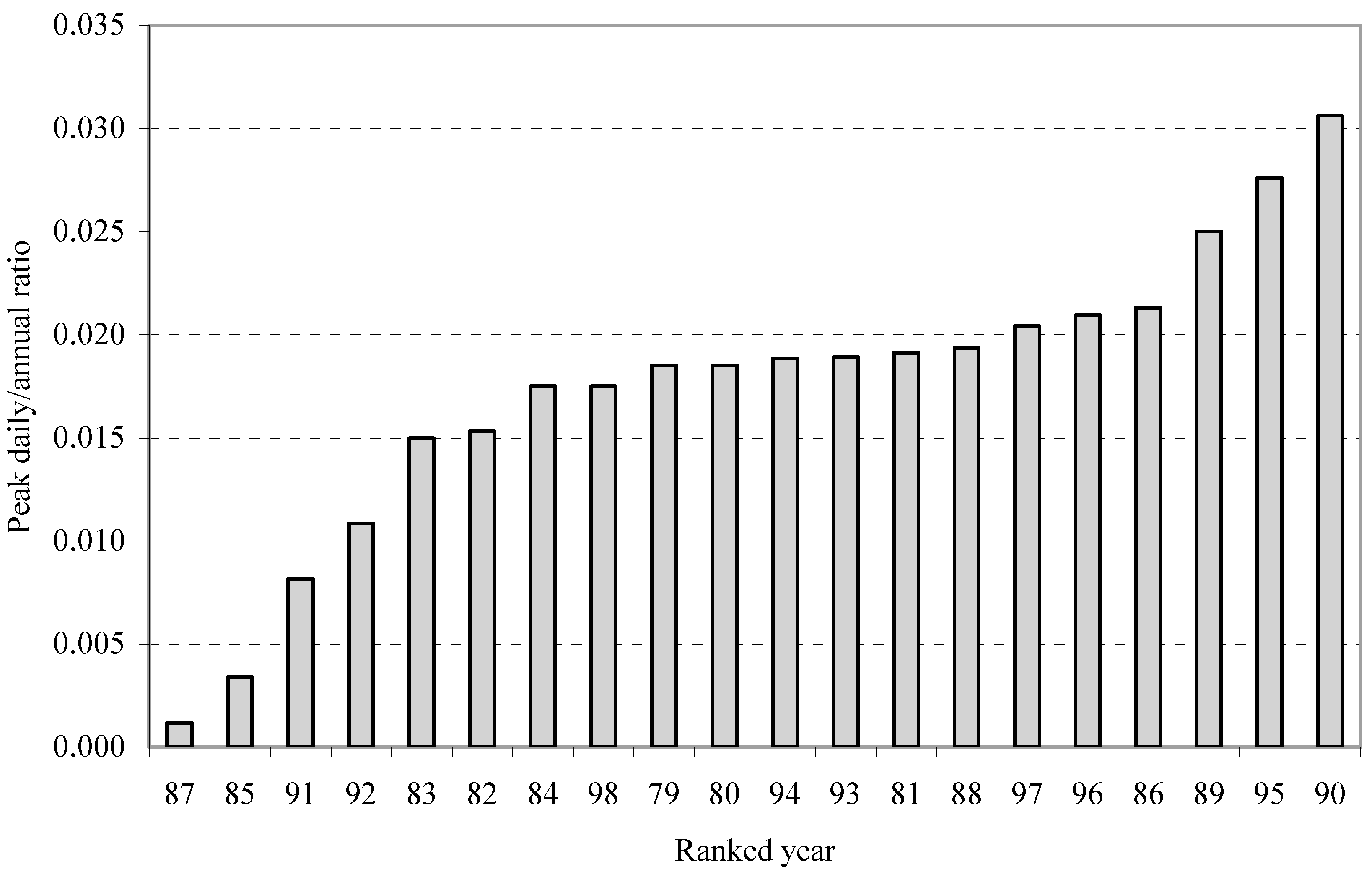
2.2. Modelling Peak Daily-to-Annual Ratios

Similarly, the IWR model was used to investigate the peak daily-to-annual ratios. For consistency, the same crop types, soil types and weather stations were used. The outputs from the IWR model for each crop-site permutation (Section 2.1) were first used to estimate the total number of irrigation events in each year. The minimum interval (i.e., the shortest number of days between two irrigation events) in each year was derived. The peak daily irrigation depth (application depth divided by the minimum interval) was then calculated. However, it should be noted that the peak daily irrigation depth will vary depending on the irrigation schedule defined for that crop. For example, with potatoes, a typical irrigation strategy might include a specific plan during tuber initiation (May–June) to control common scab disease (Streptomyces scabies) followed by a plan for the remaining summer period (July–September) for tuber bulking. This approach helps to maximise both crop yield and quality, which is critically important for vegetable crops that are destined for the pre-pack retail (supermarket) sector. In this study, the irrigation schedules were, therefore, defined to reflect best management practices to optimise both crop yield and quality [11].
A separate analysis was undertaken for each crop and for irrigation period, as defined in the irrigation schedule. This approach ensures that the minimum irrigation interval and maximum mean depth applied are calculated and used in the subsequent peak daily-to-annual calculation. In each year, the ratio between the maximum depth applied (mm d−1) and the ‘design’ dry year need (mm), was calculated. A worked example is shown in Table 2. As before, the procedure was repeated for each crop/site permutation to assess the impact of different cropping calendars, irrigation schedules, and climate on the peak daily-to-annual ratios.

2.3. Modelling Peak Monthly-to-Annual Ratios

The peak rates derived from the IWR modelling were then compared against two individual datasets: firstly, against observed data collected from a number of case study farms, and secondly, against reported irrigation abstraction data held within a national water licensing archive. A brief description of these datasets and the comparative analyses is given below.
Case study farm data: The peak monthly and peak daily ratios derived from the IWR model were compared against observed field data aggregated from 12 commercial farms, chosen to encompass the range of agroclimatic conditions under which irrigation is typically practiced in England, together with a range of irrigated crops and soil types. The location of the three weather stations used for the IWR modelling in relation to the 12 farm sites and the spatial variation in agroclimate across England and Wales is shown in Figure 2. The agroclimate zones are based on the maximum annual potential soil moisture deficit (PSMDmax), which reflects the balance between rainfall and reference evapotranspiration (ETo) and has been used extensively in international irrigation research to assess agroclimate impacts on irrigation (e.g., [12]). The farm sites were also deliberately chosen to represent irrigators that were not constrained by water resources availability and/or irrigation application equipment, which would implicitly impact on their peak abstraction rates. A site visit to each farm was undertaken, and a detailed study of irrigation equipment and management practices completed. Data collected included information on irrigated crop types and their areas (ha), water sources, irrigation scheduling practices, and application equipment, including analysis of pumping capacities. For each site, 6 years (1995–2000) historical irrigation data were obtained, which included a particularly dry year (1995) in irrigation terms. Using similar approaches to those described earlier, the peak monthly-to-annual and peak daily-to-annual ratios for each site were estimated.
The data were aggregated and the average and range in the peak ratios calculated. Although the field data were not recent, it was more important to ensure that the farm records were complete and reflected a range of agroclimatically contrasting years; this was in preference to choosing a more recent time series where a span of unusually wet or dry years could skew the statistical analysis. The choice of specific years was, therefore, less important than the historical agroclimatic variability that they represented.
National abstraction data: Most irrigators are required to meter their water abstractions and complete an annual return to the regulatory authority (EA). This summarises the timing of demand (usually monthly but sometimes daily) and provides a record of the actual volumes abstracted. These data, together with other licence information are stored in a national abstraction licensing database, termed NALD [13]. Evidence of actual monthly water usage can be derived by studying the monthly abstraction returns data. However, whilst information on the licensed quantities allocated for agriculture is in the public domain, the data on actual abstractions are confidential, unless used for research purposes. For this study, EA NALD data for Anglian Region in eastern England for the period 1997 to 2001 were provided. This area included approximately 250 irrigation abstraction licenses and accounted for a major proportion of irrigation abstraction nationally.
An assessment of the timing of irrigation demand (expressed in terms of the total volume of water abstracted in each month) for each licence in each year was completed. This identified the peak month (and mean monthly variation) in which irrigation abstraction typically occurred. However, for licence determination, peak rates of water use need to be considered for the irrigated (summer) and un-irrigated (winter) periods, separately. Using data for the largest 10% of licensed summer abstractors, the timing of mean abstraction demand during the summer period was also calculated. This was based on the ratio of the mean monthly abstraction to the total summer abstraction corresponding to the period April to September.
Finally, to compare and check whether the peak monthly-to-annual ratios derived from the IWR modelling (Section 2.1) were ‘reasonable’, an assessment of the peak monthly irrigation abstraction for all individual licenses in the region was undertaken. The annual licensed volume and monthly abstraction return data for each licence, in each year, were analysed. Across all years, the month with the maximum (peak) abstraction was identified (July 1999). For each licence, a ratio between the volume abstracted in July 1999 and the total licensed volume was calculated and used to estimate the proportion of the licensed volume abstracted in that month. Licences with zero abstraction in the reference month (July 1999) were excluded from the analysis. The variations in the proportion of the licensed volume abstracted in the peak month were then ranked and plotted relative to the proportion of irrigation abstraction licences.

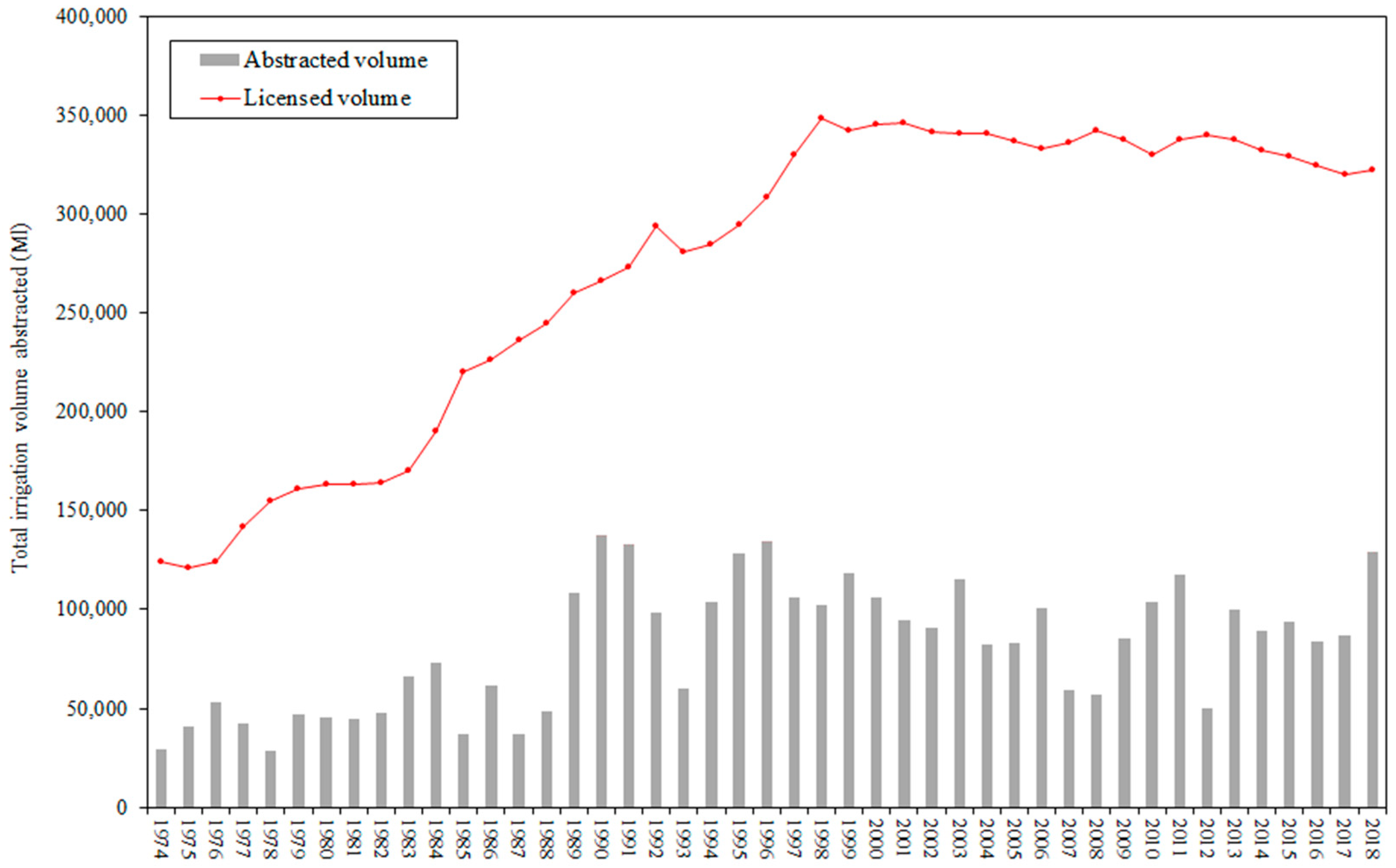
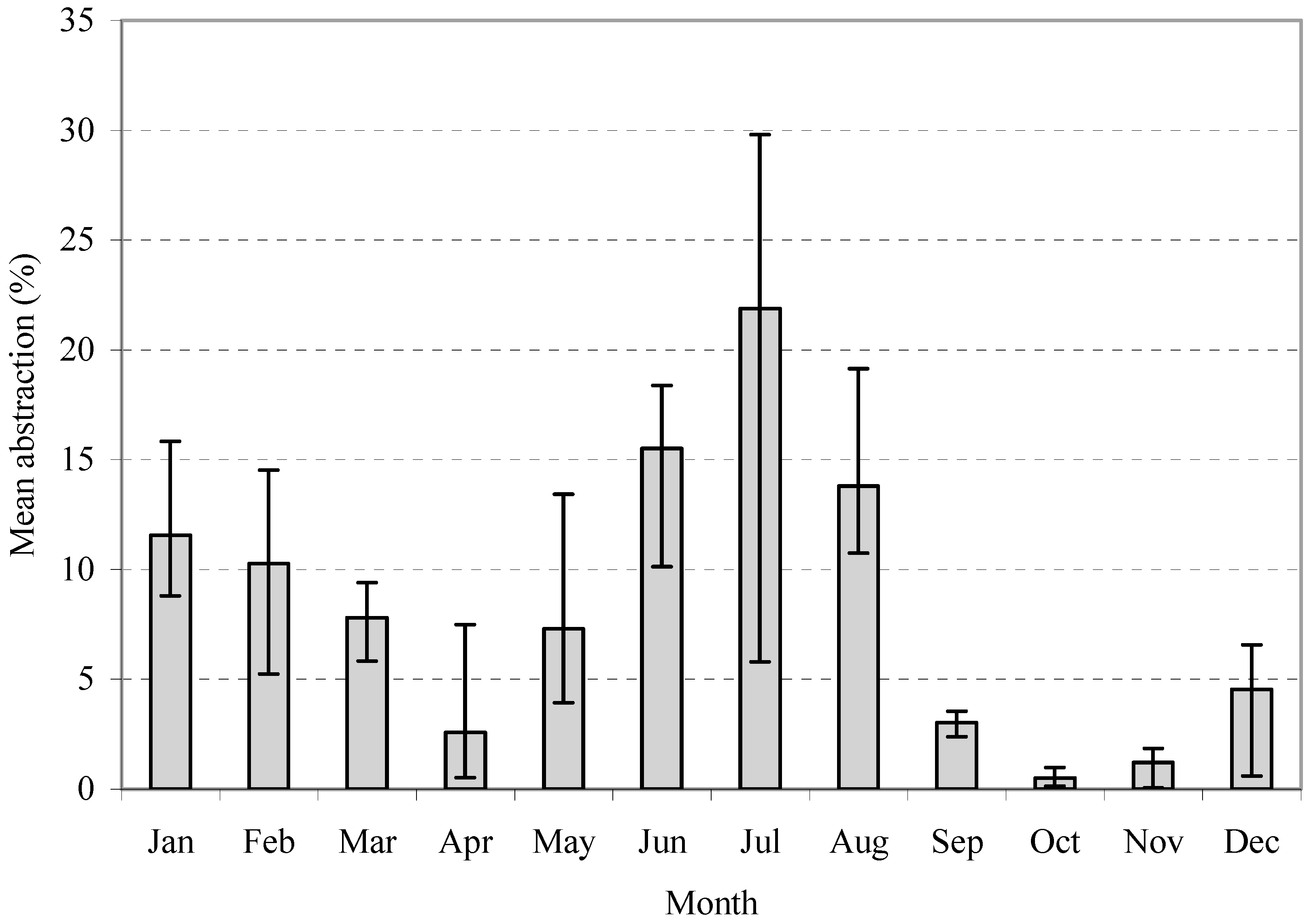
3. Results and Discussion

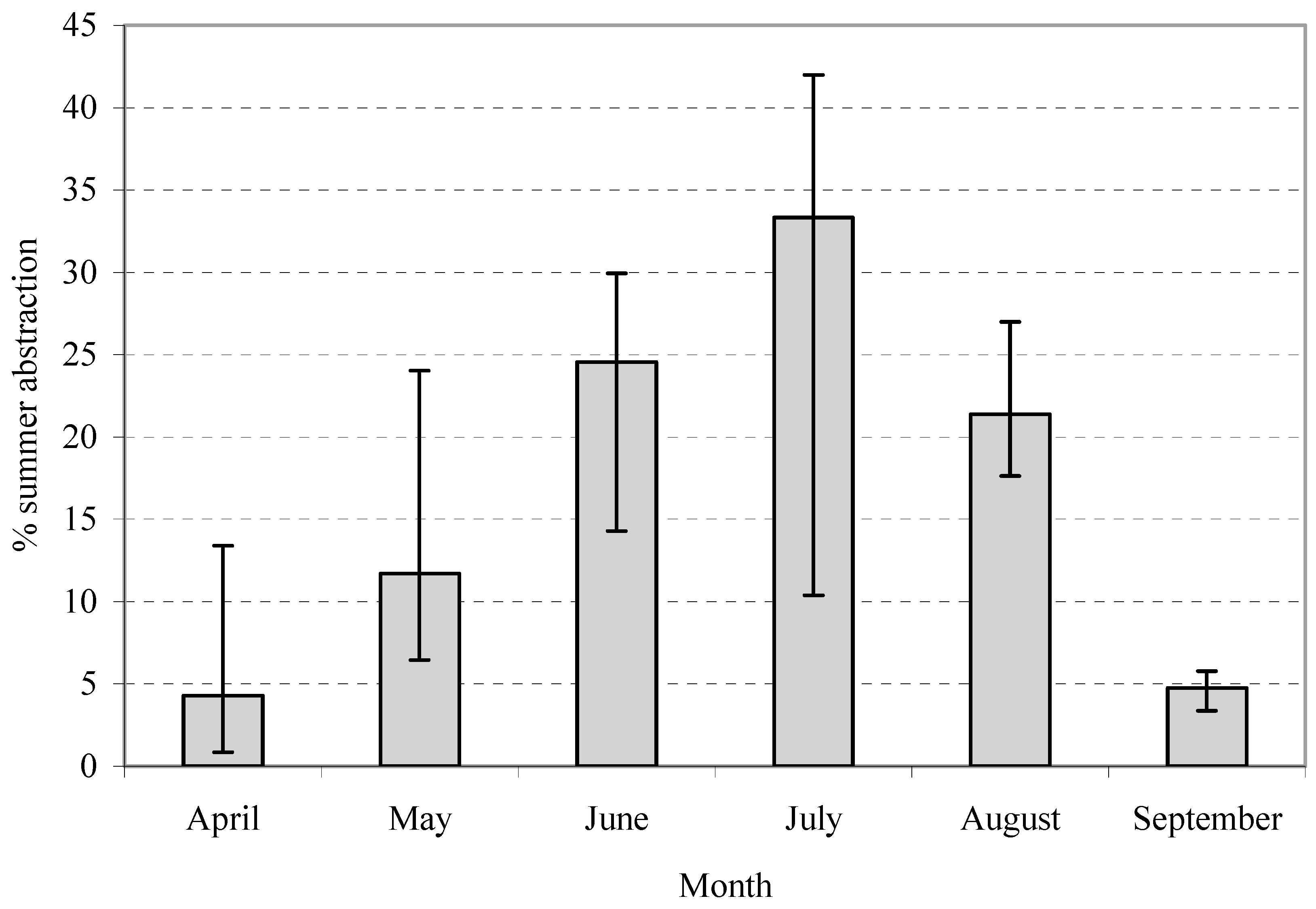
3.1. Peak Monthly-to-Annual Ratios

The typical annual variability in the ratios of peak monthly-to-annual irrigation need is shown in Figure 3. In ‘wet’ years with high summer rainfall (e.g., 1980, 1985), the ratios are low (0.12–0.15) compared to ‘dry’ years with lower summer rainfall (e.g., 1989, 1996), where the ratios were markedly higher (0.39–0.48). Setting peak monthly abstraction rates, therefore, needs to take such climatic variability into account. A summary of the peak monthly-to-annual ratios, by crop type for each site is shown in Table 3. The analysis suggests that a peak monthly requirement (m3 month−1) for an abstraction licence should typically allow an irrigator to abstract between 0.4 and 0.5 (40 to 50%) of their annual licensed volume. It should be recognised, however, that this approach only considers single outdoor-irrigated cropping systems. Multiple-irrigated cropping (e.g., sequential lettuce production) or protected cropping (e.g., strawberries) will tend to extend the irrigation season. Conversely, some specialist short-season shallow-rooting crops may have higher monthly peaks.

3.2. Peak Daily-to-Annual Ratios

The typical annual variability in the ratios of peak daily-to-annual irrigation needs is shown in Figure 4. As before, for each crop–site permutation, the data were statistically analysed to derive a peak daily-to-annual ratio for a ‘design’ dry year. These ratios were then adjusted to reflect a 6-day irrigation week, allowing for one day per week without irrigation for other duties (e.g., crop spraying, equipment maintenance). A summary of the peak daily-to-annual ratios, by crop type for each site, is shown in Table 4. The analysis suggests that a peak daily requirement (m3·day−1) for an irrigation abstraction licence should typically allow a farmer to abstract between 0.025 and 0.035 (2.5 to 3.5%) of their annual licensed volume on a given peak day.

3.3. Comparison of Modelled Peak Rates with Observed Datasets

Farm-level abstraction data: A comparison of the IWR-modelled peak monthly- and peak daily-to-annual rates against the observed data obtained from the 12 case study farms is given in Table 5. There is reasonable agreement between the modelled and observed peak monthly-to-annual ratios. However, the IWR model considers only single-irrigated cropping systems. Multiple-irrigated cropping, as practiced on some of these commercial farms, would result in an extended irrigation season, with a consequent likely decrease in the peak monthly demand. However, the mix of high-value, short-season crops increasingly being grown within more traditional arable crop rotations reflects a greater range in peak monthly abstraction rates. There is also good agreement between the modelled and observed peak daily-to-annual ratios, although again, the observed range in actual abstraction rates shows greater variation than that within the modelled results. This is a reflection of different farming systems (with different crop mixes and irrigation schedules) being included in the 12 case study farms leading to a greater range in the observed peak monthly-to-annual ratios, compared to the modelling approach, which used a single crop and defined irrigation schedule. Overall, the comparison between the IWR-modelled data with the observed farm data confirms a high degree of confidence and a reasonably sound basis for developing guidelines for setting peak monthly and daily abstraction rates.
National abstraction data: The monthly pattern of irrigation abstraction in the EA Anglian Region is shown in Figure 5, expressed as the percentage of the mean monthly abstracted volume to the mean annual abstracted volume. Over the period studied, July, on average, represents the peak month for abstraction, accounting for approximately 22% of total annual abstraction. The mean monthly variation between years is also shown. The timing of abstraction demand for the top 10% of licensed abstractors in the region for the summer period (April to September) is shown in Figure 6, expressed as the ratio of mean monthly abstraction to total summer abstraction. The mean monthly variation between years is also shown. The data confirm that, on average, between 30% and 40% of total summer abstraction occurs in July, the peak month. However, on individual farms, this proportion was often much higher, perhaps, for example, where an abstraction licence was being used to irrigate specialist crops.
The variation between approximately 250 farms in the proportion of the licensed volume abstracted in the peak month is shown in Figure 7. This shows that setting a 50% peak monthly-to-annual ratio (as suggested in Section 3.1) would have satisfied 95% of irrigation abstractors’ needs. An analysis of the frequency distribution of these irrigated holdings confirmed that those whose peak monthly demand exceeded 50% accounted for only 6% of total abstraction in that year. These are likely to be small area farms, with small licenses, but irrigating high-value, shallow-rooting crops.

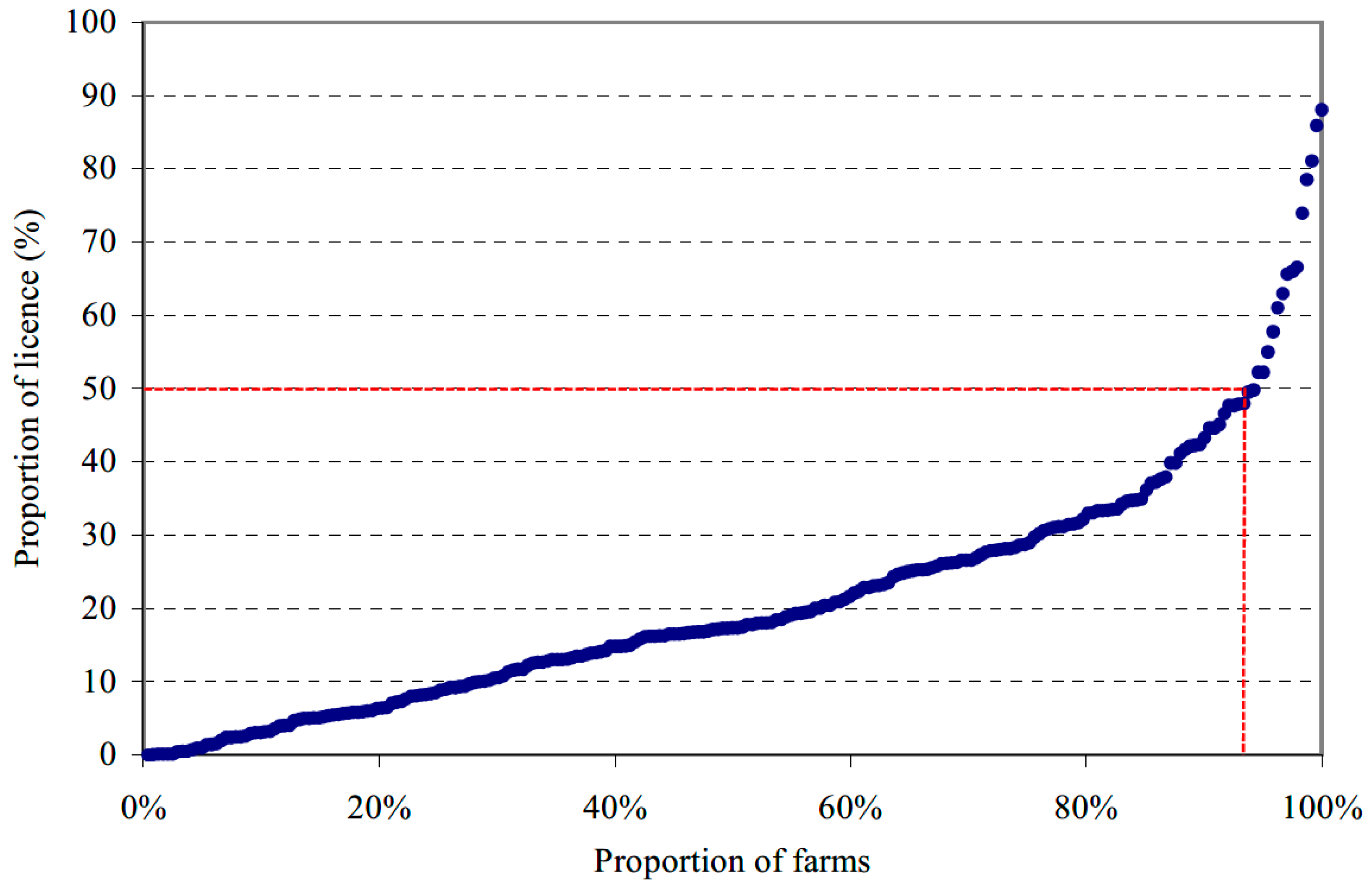
3.4. Other Considerations

The methodology described thus far relates to setting peak monthly and daily abstraction rates. There are, however, additional water resource and application equipment issues that must be taken into consideration in developing a scientifically robust methodology for use in setting peak abstraction rates within water permits or licenses.
Peak hourly and absolute rates: Once a peak daily rate has been determined, the peak hourly rate is largely set by the hours available to complete the irrigation and the flow requirements of the irrigation equipment. For all irrigation systems, the peak absolute and peak hourly rates can be the same; every system would be expected to run continuously for over an hour at peak.
Hours available: In the absence of abstraction restrictions, for example, when irrigating from a storage reservoir, most large-scale farming enterprises using overhead systems (e.g., sprinklers, hose-reel irrigators, or booms) would typically plan to complete their irrigation in about 16 h. This provides sufficient flexibility for unavoidable down-time, equipment maintenance, and moving equipment between fields, as well as reducing the need for equipment moves at night. There are, however, other circumstances that can also reduce the irrigation hours available. These could include, for example, (i) non-standard field sizes that make it impossible to use travelling irrigators for the full run-time every day; (ii) small-scale irrigators that may not have the staff and/or automation required to spread irrigation out over so many hours; (iii) lower evaporation, less wind, and off-peak electricity tariffs make it more efficient to irrigate only at night; (iv) golf courses sometimes need to irrigate in as few as 8 h overnight, starting after the last players leave at dusk and finishing in time for water to infiltrate before the early morning golfers arrive; (v) noise issues (diesel pumps, impact sprinklers) may restrict night-time irrigation, and (vi) health and safety considerations advise against moving portable equipment in the dark. In such cases, irrigators have to invest in additional irrigation equipment and apply the scheduled water in fewer hours, and, hence, will require abstraction licences with appropriate conditions and/or storage tanks to accommodate for localised peaks in demand.
Equipment flow rates: The flow rate of an irrigation system is set by its design. Most irrigation equipment has a wide range of flow rates available but can only be used over a narrow range once purchased. Hose-reel systems have a range of sizes and nozzles, but these must be matched to the size and shape of the fields as well as to the licence. Static sprinkler systems similarly need flexibility to be assembled in different arrangements on different fields. Minimum flow rates, to attain adequate uniformity, may require higher flows than typical working hours would suggest. Centre pivots and linear move systems often have a required flow rate set by the standard sprinkler packages available. Trickle (or drip irrigation) systems on row crops will typically apply the daily requirements in only one or two hours; however, the irrigation is cycled around sectors to minimise peak flows and pump size. Field size and shape may also influence the sector size.
Tanks and balancing reservoirs: Where abstraction is via a storage tank or reservoir, equipment flow rates are not an issue; the tank can be filled at a constant rate to balance higher short-term application rates. The use of a tank or balancing reservoir, therefore, allows an abstractor to smooth out peaks in irrigation demand and allows significantly lower peak ratios. Relatively small tanks can spread hourly peaks over a day’s abstraction; many days’ storage would be needed to spread daily peaks; a half season’s reservoir storage may be needed to spread monthly peaks. Where the irrigator also has a licence to abstract water during the winter months (high river flows), the storage reservoir may provide a balancing function for the summer abstraction by pumping via the reservoir. However, the additional capital cost and energy use due to double pumping does need to be considered.
Environmental sensitivity and flow constraints: The environmental sensitivity to peak abstraction rates depends on the water source. Minor streams and rivers whose flow is small compared to the abstractions are particularly sensitive to the peak absolute and peak hourly rates. Large surface water bodies, whose water level is barely affected by short-term pumping, are mostly sensitive to monthly or even total seasonal abstraction. Groundwater in unconfined aquifers is typically most sensitive to monthly or total seasonal abstraction; in confined aquifers shorter duration rates may be more important. The situation becomes more complex when one source is feeding into another, for example aquifers feeding spring lines or streams. In each case, it is recommended that the most sensitive peak rates be identified and set first. Sensitivity must also be judged in the context of the other licence conditions, and a regulatory requirement to balance not only the environmental impacts but also the economic implications of setting unnecessarily stringent constraints on peak rates of abstraction, which would have negative impacts on the financial value and benefits of water used for agriculture. Setting peak rates will also need to consider the future impacts of a changing climate with increased drought risks impacting on both agronomic volumetric demands and timing of irrigation, and any changes in the availability of water due to reduced river flows (). The number of different rates stipulated in a licence should, therefore, be kept to the minimum and only set where necessary. In catchments where both irrigation and aquatic dependent ecosystems are concentrated, environmental impact assessments may also be required to ensure environmental flows are not impacted by over-abstraction, particularly in dry years. However, most licences now have ‘Hands-off Flow’ (HoF) conditions which preclude farmers from abstracting once prescribed river flows (or groundwater levels) drop below defined levels to protect the environment and other abstractors.
Finally, it is worth mentioning that there is, unfortunately, no comparative scientific literature on the topic of peak rates for irrigation abstraction against which our modelled outputs can be compared. Further studies should be undertaken in other countries under differing crop and agroclimatic conditions to facilitate future comparison.

4. Application

Collectively, the IWR-modelled results, the observed data from the case study farms, and the analysis of abstraction data have been used to develop guidelines to assist the regulatory authority in setting peak abstraction rates. The procedure takes into account the source/s of water used for irrigation (with and without storage) and the abstraction period (summer or winter). The proposed peak abstraction rates, expressed as a fraction of the licensed annual abstraction, are given in Table 6. For example, the suggested fractions for summer abstraction direct to irrigation suggest the regulatory authority should allow for 20 days (e.g., 4 weeks at 5 days per week) irrigation with an average 15 h day during the peak month, using up half the annual water requirement. Alternatively, they would allow irrigation for 10 h per night every night during the peak month, using up half the annual water requirement, or 8 h per night every night during the peak month using 40% of the annual water requirement. Exceptions may be justified in some cases, for example, (i) irrigators with limited soil water storage, e.g., with shallow-rooting crops and/or light soils and/or trickle irrigation, may have extreme peaks lasting only a few days, and may need a higher daily-to-annual ratio to cope with these circumstances, (ii) specialised growers with a limited range of crops may have a shorter growing season, and need higher monthly-to- annual and daily-to-annual ratios, and (iii) small-scale irrigators may not be able to spread irrigation over as many hours per day as larger commercial growers, nor irrigate 6 days a week, and, hence, require higher hourly-to-annual and daily-to-annual ratios.
The suggested figures for winter abstraction from surface water to reservoir storage allow for 720 h of pumping. Utilising off-peak electricity, this could be 120 days at 6 h d−1 or 90 days at 8 h d−1. However, if the water source was unreliable, the option of pumping continuously for 30 days should be retained, if possible. The suggested figures for winter abstraction from groundwater to reservoir storage allow for 90 days continuous pumping. A brief description of the application of the proposed methodology is given as follows: (i) the minimum flow/water level conditions to which the abstraction licence will be subjected is determined; (ii) the sensitivity of the water sources to any of monthly, daily, hourly, and/or absolute peak flow rates under those conditions is assessed; (iii) for the most sensitive duration, the peak rates given in Table 6 are used to determine whether adequate environmental protection will be provided; and (iv) for other durations, and only where necessary, less onerous (higher) rates should be set. Rates should not be set where there are no hydrological benefits or where necessary environmental protection has already been catered for in other licence restrictions. It should be noted that the suggested ratios given in Table 6 only set limits on how fast the water can be abstracted. Slower abstraction rates and longer working hours are not precluded.
The methodology described in this paper forms part of the national abstraction licensing policy in England. It is now being used to provide practical guidance for EA water resources staff involved in assessing abstraction licenses for agricultural irrigation. It provides a relatively simple yet scientifically based and rational approach for setting peak rates of abstraction and represents an important component in the decision-making process of allocating water between irrigators or between irrigators and competing uses (e.g., industry, leisure, the environment). Although the procedure was developed in a humid environment, where irrigation is supplemental to rainfall, the procedure is equally applicable in other countries, including temperate, arid, or semi-arid environments. This would require the approach to take into account the different crop types that are grown, how they are scheduled (timing and amounts of water applied), consideration of the agroclimate variation that exists from year to year, and the different water sources used for agriculture and their environmental sensitivity to abstraction.

5. Conclusions

A methodology has been developed that provides guidelines for supporting water regulatory agencies in setting ‘reasonable’ peak rates for irrigation abstraction, from a combination of different water sources, including surface water, groundwater, and storage reservoirs. The procedure allows regulatory authorities responsible for managing and allocating water resources to set sensible limits in abstraction licenses (permits) for agriculture to protect the aquatic environment from over-abstraction whilst also protecting the needs of individual abstractors. The procedure forms part of a wider study into assessing the optimum use of water in agriculture and is an important contribution to the decision-making process of allocating water between irrigators or between irrigators and competing uses, particularly as competition for water abstraction between different sectors and the environment comes under increasing scrutiny and environmental pressure. The procedure assumes that future access to water is unconstrained; however, increasing water scarcity in many countries, including England, will inevitably mean that the ‘reasonable’ peak rates as developed in this research and required by the agricultural sector to maximise crop yields will not be attainable as rivers and groundwater sources become increasingly constrained and less reliable. The peak rates will remain valid for farmers seeking to engineer and build new water sources (e.g., storage reservoirs) as an adaption response to increased water supply risks. The procedure could also be further developed and tested for other high-value crop sectors (e.g., protected horticulture under glasshouses) and for the landscape and amenity (golf) sectors.

Author Contributions

Conceptualization, K.W. and J.W.K.; methodology, K.W. and J.W.K.; formal analysis, J.W.K.; writing—original draft preparation, J.W.K. and K.W.; writing—review and editing, J.W.K.; funding acquisition, J.W.K. All authors have read and agreed to the published version of the manuscript.

Funding

This research was funded by the UK Environment Agency.

Data Availability Statement

All data supporting this study are included within the article.

Acknowledgments

The authors acknowledge the assistance of EA staff for the provision of licensed and abstraction data, and the individual farm businesses who participated in the research.

Conflicts of Interest

The authors declare no conflicts of interest.

References

  1. Knox, J.W.; Haro-Monteagudo, D.; Hess, T.M.; Morris, J. Identifying trade-offs and reconciling competing demands for water: Integrating agriculture into a robust decision-making framework. Earth’s Future 2018, 6, 1457–1470. [Google Scholar] [CrossRef]
  2. Water Resources East (2023). The Regional Water Resources Plan for Eastern England. Available online: https://wre.org.uk/the-regional-plan/ (accessed on 6 December 2023).
  3. Environment Agency. Water Abstraction Plan 2017. Setting Out How the Government Will Reform the Way We Manage Water Abstraction, to Protect the Environment and Improve Access to Water. 2017. Available online: https://www.gov.uk/government/publications/water-abstraction-plan-2017 (accessed on 11 December 2023).
  4. Defra. Water Abstraction Statistics: England, 2000 to 2018. 2023. Available online: https://www.gov.uk/government/statistical-data-sets/env15-water-abstraction-tables (accessed on 6 December 2023).
  5. Mathieson, I.K.; Knox, J.W.; Weatherhead, E.K.; Morris, J.; Jones, D.O.; Yates, A.J.; Williams, N.D. Optimum Use of Water for Industry and Agriculture: Environment Agency R&D Technical Report W243; Environment Agency: Bristol, UK, 2000.
  6. Ahmad, M.J.; Cho, G.-H.; Choi, K.S. Historical climate change impacts on the water balance and storage capacity of agricultural reservoirs in small ungauged watersheds. J. Hydrol. Reg. Stud. 2022, 41, 101114. [Google Scholar] [CrossRef]
  7. Hess, T.M. IWR. An Irrigation Water Requirements Programme. User Manual; Silsoe College: Bedford, UK, 1994; unpubl. [Google Scholar]
  8. Allen, R.G.; Smith, M.; Perrier, A.; Pereira, L.S. An update for the definition of reference evapotranspiration. Irrig. Drain. 1994, 42, 1–34. [Google Scholar]
  9. Ritchie, J.T. Model for predicting evaporation from a row crop with incomplete cover. Water Resour. Res. 1972, 8, 1204–1213. [Google Scholar] [CrossRef]
  10. Knox, J.W.; Weatherhead, E.K.; Bradley, R.I. Mapping the total volumetric irrigation water requirements in England and Wales. Agric. Water Manag. 1997, 33, 1–19. [Google Scholar] [CrossRef]
  11. Sutcliffe, C.; Knox, J.W.; Hess, T.M. Managing irrigation under pressure: How supply chain demands and environmental objectives drive imbalance in agricultural resilience to water shortages. Agric. Water Manag. 2021, 243, 106484. [Google Scholar] [CrossRef]
  12. De Silva, C.S.; Weatherhead, E.K.; Knox, J.W.; Rodriguez-Diaz, J.A. Mapping the climate change impacts on irrigation water requirements for Maha season paddy rice in Sri Lanka. Agric. Water Manag. 2007, 93, 19–29. [Google Scholar] [CrossRef]
  13. EA. NALD Purpose Code Design Notes: Purpose Code Definitions; Environment Agency: Peterborough, UK, 1996.
Figure 1. Total licensed and abstracted volumes of water for agricultural irrigation in England between 1974 and 2018 (Source [4]).
Hydrology 11 00033 g001
Figure 2. Location of weather stations used for irrigation modelling and farm case study sites in relation to the spatial distribution of agroclimate variability across England and Wales. Black line boundaries represent Environment Agency regions.
Hydrology 11 00033 g002
Figure 3. Ranked peak monthly-to-annual ratios for potatoes at Silsoe (Bedfordshire). The year 1981 with a ratio of 0.41 is equivalent to a ‘design’ dry year with 80% probability of non-exceedance.
Hydrology 11 00033 g003
Figure 4. Ranked peak daily-to-annual ratios for potatoes at Silsoe (Bedfordshire). The year 1989 with a ratio of 0.024 is equivalent to a ‘design’ dry year with 80% probability of non-exceedance.
Hydrology 11 00033 g004
Figure 5. Monthly pattern of mean abstraction for spray irrigation for Anglian Region, 1997–2001. Error bars show inter-annual variation from the monthly mean.
Hydrology 11 00033 g005
Figure 6. Monthly pattern of summer abstraction for spray irrigation for the top 10% of licensed summer abstractors in Anglian Region (1997–2001). Error bars show inter-annual variation from the mean.
Hydrology 11 00033 g006
Figure 7. Variation in the proportion of the licensed volume abstracted in the peak month (July) for irrigation abstractors (largest 10% sample) in Anglian Region in 1999. Setting a 50% peak monthly-to-annual ratio would satisfy 95% of irrigation abstractors’ needs in this area (as shown by the red line).
Hydrology 11 00033 g007
Table 1. IWR-modelled irrigation needs (monthly) and peak monthly-to-annual ratios for maincrop potatoes at Silsoe (Bedfordshire), 1979–1998.
Month19791980198119821983198419851986198719881989199019911992199319941995199619971998
IWR modelled monthly irrigation needs (mm)
January00000000000000000000
February00000000000000000000
March00000000000000000000
April00000000000000000000
May04004302525025161866152215025436018
June493282314935065047805103116506999330
July910415069652542004268250196792665065
August2500255050250255075752502525100505075
September00000000002502502500000
October00000000000000000000
November00000000000000000000
December00000000000000000000
Ranked monthly irrigation needs (mm)
91408250696525652550807525312567100996075
4932414350502542254775682522255092665065
25003149352500164266250192569505018
00025025000025511501602543330
0000000000180001500000
00000000000000000000
00000000000000000000
00000000000000000000
00000000000000000000
00000000000000000000
00000000000000000000
00000000000000000000
Annual need1647212214816817575108501132412609053100142285258192159
‘Design’ dry year need204204204204204204204204204204204204204204204204204204204204
Peak monthly to design dry year ratio0.440.200.400.250.340.320.120.320.120.250.390.370.120.150.120.330.490.480.290.37
Table 2. IWR-modelled irrigation needs and peak daily-to-annual ratios for maincrop potatoes at Silsoe (Bedfordshire), 1979–1998.
Year19791980198119821983198419851986198719881989199019911992199319941995199619971998
Period 1 (scab control)
No. of irrigations43623305047503335842
Min. interval (days)444855-4-436-75434739
Depth applied (mm)15.115.115.615.415.315.2-17.4-15.815.317.7-15.519.315.416.917.126.615.2
Mean depth over minimum interval (mm/day)3.783.783.901.933.063.04-4.35-3.955.102.95-2.213.863.855.634.283.800.39
Period 2 (summer irrigation)
No. of irrigations40134421125530137445
Min. interval (days)7-278973636104127415-2975767
Depth applied (mm)25-2525252525252525252525-252525252525
Mean depth over minimum interval (mm/day)3.57-0.933.132.783.570.690.930.241.923.576.251.67-0.863.575.003.574.173.57
Max depth (mm/day)3.783.783.903.133.063.570.694.350.243.955.106.251.672.213.863.855.634.284.173.57
‘Design’ dry year need (mm)204204204204204204204204204204204204204204204204204204204204
Peak daily to design dry year ratio0.0190.0190.0190.0150.0150.0180.0030.0210.0010.0190.0250.0310.0080.0110.0190.0190.0280.0210.0200.018
Table 3. Summary of IWR-modelled peak monthly-to-annual ratios for a ‘design’ dry year (80% non-exceedance), by crop type, for three agroclimatically contrasting sites.
Crop CategoryWye (Kent)Shawbury (Shropshire)Silsoe (Bedfordshire)
Potatoes (maincrop)0.440.420.41
Sugar beet0.530.520.51
Vegetables (carrots)0.450.450.41
Table 4. Summary of IWR-modelled peak daily-to-annual ratios for a ‘design’ dry year (80% non-exceedance), by crop type, for the three sites.
Crop CategoryWye (Kent)Shawbury (Shropshire)Silsoe (Bedfordshire)
Potatoes (maincrop)0.0280.0290.027
Sugar beet0.0250.0210.025
Vegetables (carrots)0.0320.0340.032
Table 5. Comparison of IWR-modelled peak monthly-to-annual rates and peak daily-to-annual rates against observed data from case study farms.
RatioModelled (IWR)Observed (Case Study Farms)
RangeAverageRangeAverage
Peak monthly to annual0.410–0.5300.4600.470–0.8400.660
Peak daily to annual0.021–0.0340.0280.019–0.0520.028
Table 6. Suggested peak rates, expressed as a fraction of licensed annual abstraction (m3), for different water source combinations.
Summer abstraction direct to irrigation:
PeriodUnitsFraction of licensed annual abstraction (m3)
Monthlym3/month1/2
Dailym3/day1/40
Hourlym3/h1/600
Absolutem3/hAs hourly
Winter abstraction from surface water to reservoir storage *:
PeriodUnitsFraction of licensed annual abstraction (m3)
Monthlym3/month1 to 1/3 (depending on source reliability)
Dailym3/day1/30 to 1/90 (depending on source reliability)
Hourlym3/h1/720
Absolutem3/hAs hourly
Winter abstraction from groundwater to reservoir storage:
PeriodUnitsFraction of licensed annual abstraction (m3)
Monthlym3/month1/3
Dailym3/day1/90
Hourlym3/h1/2160
Absolutem3/hAs hourly
* These values should not be used where high ‘hands-off flows’ (restrictions) have been set and the abstractor has agreed to take water at high flows or flood conditions only.
Disclaimer/Publisher’s Note: The statements, opinions and data contained in all publications are solely those of the individual author(s) and contributor(s) and not of MDPI and/or the editor(s). MDPI and/or the editor(s) disclaim responsibility for any injury to people or property resulting from any ideas, methods, instructions or products referred to in the content.

