1. Introduction
KCCs are widely distributed across more than 20 coalfields in North China [
1]. Water inrush accidents induced by KCCs are characterized by concealment, delay, and suddenness, posing a major threat to coal mine production safety [
2,
3]. Historically, several severe water inrush incidents caused by KCCs have occurred in North China coalfields, resulting in significant economic losses and heavy casualties [
4,
5,
6]. In recent years, as coal mining extends to greater depths, the risk of water inrush disasters has become increasingly serious [
7,
8]. Therefore, conducting comprehensive detection, treatment, and safety evaluation of KCCs is of great practical importance for providing a theoretical basis for the prevention and control of water inrush disasters.
To identify concealed collapse columns during mining, many researchers have initially focused on the formation mechanisms and morphological characteristics of such features [
9,
10,
11]. In plan view, collapse columns are primarily circular, elliptical, or triangular [
12,
13], while in profile, they typically appear cylindrical or conical [
14]. In North China coalfields, KCCs are concealed vertical water-conducting structures formed by karst subsidence within Ordovician limestone aquifers [
15,
16,
17]. Karst cavities gradually expand upward and may eventually collapse through the coal seam, ultimately forming a plug-shaped geological structure [
18,
19].
Some hydrogeologists have shifted their focus toward detection methods, prevention and treatment strategies, and safety evaluation of KCCs [
20,
21,
22]. Geophysical prospecting based on differences in physical properties of rock layer, such as density and electrical resistivity, has been widely applied in detecting anomalous geological structures, and can be combined with in-situ drilling exploration to determine whether collapse columns are developed in the targeted area [
23,
24]. Large-scale exploration of coal mines is carried out by ground high-power transient electromagnetic surveys, three-dimensional seismic surveys, and surface electrical resistivity tomography [
25,
26,
27]. Transient electromagnetic, in-seam seismic, direct current, and audio-frequency electric perspective methods are used to investigate the development of suspected collapsed columns in underground mines [
28]. Based on the preliminary investigation of KCCs, several measures are conducted to prevent and control water-inrush hazards caused by KCCs, such as grouting consolidation and setting aside reasonable water-resisting coal or rock pillars [
29,
30,
31]. It is necessary to evaluate the effect of collapse column exploration, treatment, and to analyze whether the risk of water inrush is eliminated; however, few relevant studies have been published.
The theoretical underpinnings of the present study derive from classical hydrogeology. Hubbert [
32] first introduced the concept of fluid potential to describe groundwater motion in porous media, while Tóth [
33] proposed the theory of groundwater flow systems, distinguishing local, intermediate, and regional flow patterns. A systematic mathematical treatment of flow through porous media was provided by Bear [
34]. For karst environments, the hydrogeological framework for understanding collapse column development is established in the classical works of White [
35], Milanović [
36], and Dreiss [
37], which address dissolution kinetics, spring hydrograph analysis, and regional-scale transport. In the context of numerical modeling, Konikow and Bredehoeft [
38] critically examined the concept of model validation, and Anderson and Woessner [
39] presented comprehensive methodologies for model development and calibration. With specific regard to mine water hazards, Yin et al. [
40] systematically characterized water inrush patterns and theoretical criteria of karst collapse columns in North China coalfields. The water inrush coefficient, defined as the water pressure that can be sustained by the unit aquiclude thickness of the coal seam floor, was first put forward at the Jiaozuo Mine Water Control Conference [
41]. Zhang et al. [
42] further elaborated groundwater system theory and its practical applications in hydrogeological analysis.
Based on the reviewed literature, we propose the following conceptual framework and testable propositions to guide our case study: (i) multi-branch grouting should seal the hydraulic pathway of a KCC if the grouting pressure exceeds 1.5 times the aquifer pressure and the slurry reaches the targeted fracture zones; (ii) a multi-index closed-loop verification system (combining geophysical prospecting, borehole inflow monitoring, water inrush coefficient calculation, and numerical simulation) provides a more reliable assessment than any single-index method; (iii) after grouting reinforcement, the water inrush coefficient of the coal seam floor can be reduced to well below the general safety threshold of 0.06 MPa/m, even when initial values were high. The following sections describe how this case study tests these propositions under the specific hydrogeological conditions of the Huainan mining area.
Taking the Zhangji coal mine as a case study, we propose a complete surface-underground integrated system for KCC detection, multi-branch grouting, and multi-index verification. A simulation model is built to quantitatively simulate groundwater evolution during drainage and grouting. A closed-loop evaluation framework is adopted to achieve more systematic and reliable validation. The research results provide a reference for the prevention and control of mine water disasters in Huainan mining areas.
2. Study Area
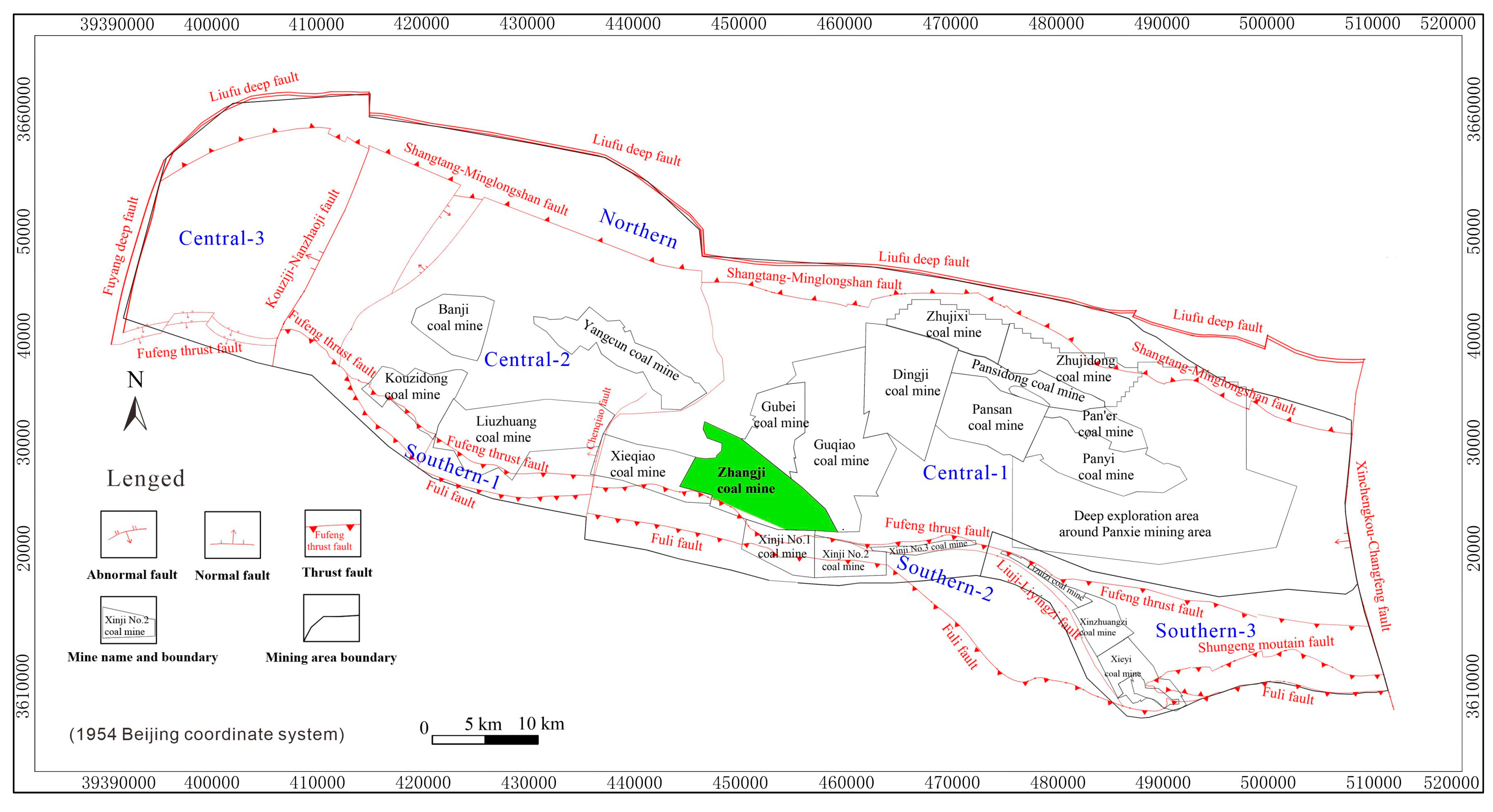
The Zhangji Coal Mine, which belonging to Huaihe Energy (Group) Co., Ltd., is located at longitudes 116°27′05″ E to 116°35′38″ E and latitudes 32°43′47″ N to 32°49′26″ N in Huainan Mining Area of Anhui Province, China, as shown in
Figure 1.
The hydrogeological units in the Huainan mining area are divided into three units according to fault distribution: the Northern Unit, the Central Unit, and the Southern Unit. The Central and Southern Units are further classified into three and four subcategories (Central-1 to Central-3 and Southern-1 to Southern-4), respectively. The hydrogeological type of the Zhangji coal mine belongs to Central-1.
The aquifers in the Zhangji Coal Mine consist of pore water in the loose sand layer, fracture water in the Permian sandstone, and karst fracture water in limestone. The thickness of the loose layer varies with paleogeomorphology, showing greater thickness in the north than in the south. The bottom of the loose layer is composed of “red sandstone with clay”, which can block the upper water body and rainfall from entering the lower strata. The water-bearing layer located in the Permian sandstone fissure is mainly medium-fine sandstone, with local coarse sandstone and quartz sandstone distributed between the minable seam and mudstone; the lithology and thickness vary greatly. The recharge water volume is generally uneven, primarily derived from static reserves.
The limestone karst fissure aquifers are developed in the Taiyuan Formation of The Carboniferous period and the middle and upper parts of Ordovician period in the coal mine. Forty-three drillings distributed within the mine area penetrate the limestone aquifers. The Taiyuan Formation is composed of thin limestone, mudstone, and sandy mudstone. The total thickness of the Taiyuan Formation limestone strata is 108.55 to 122.95 m, with an average of 114.42 m, while the total thickness of limestone layers is 62.25 to 68.40 m, averaging 65.19 m, accounting for 56.97% of the total thickness. This formation contains 10~12 limestone aquifers, which are divided into three groups from top to bottom: the C
3I group (No. 1 to No. 3), the C
3II group (No. 4 to No. 9), and the C
3III group (No. 10 to No. 12), from top to bottom. The unit water inflow of the C
3I aquifer ranges from 0.000045 to 0.00973 L/(s·m), and the permeability coefficient ranges from 0.000138 to 2.935 m/d. The Ordovician strata are mainly composed of dolomitic thick limestone, with an exposed thickness of 33.90 to 88.40 m. The unit water inflow is 0.000119 to 2.773 L/(s·m), and the permeability coefficient is 0.000146 to 0.039 m/d. Due to the development of a stable aquiclude between the C
3I aquifer and the lower C
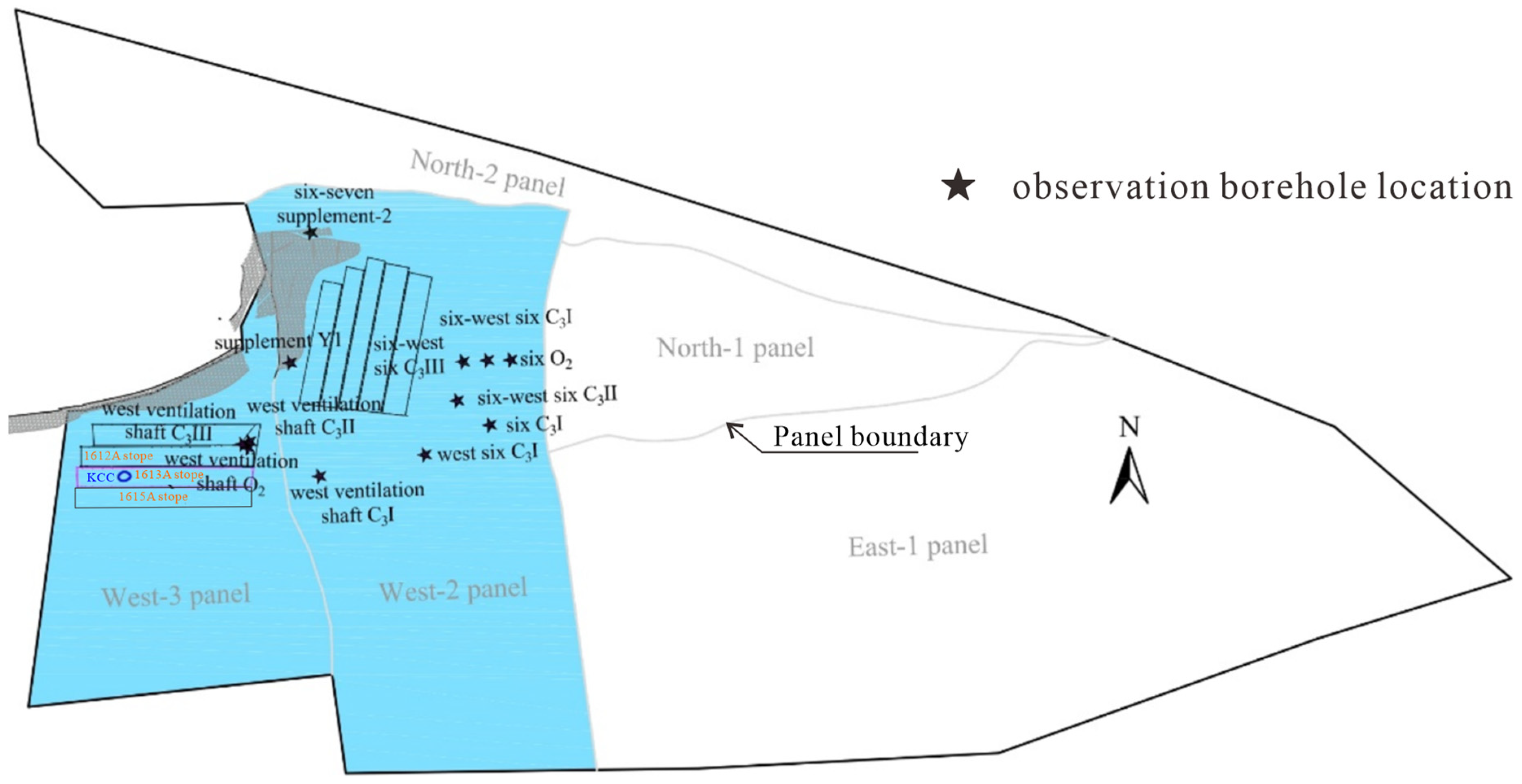
3II aquifer, hydraulic connection between them is weak under intact formation conditions. Meanwhile, 12 hydrogeological limestone observation wells are distributed in the West-2 Panel and West-3 Panel, as shown in
Figure 2 and
Table 1. Considering the safe excavation of the roadway, Six C
3I and West six C
3I were grouted; water level observations are no longer performed.
The excavation of the No. 1 coal seam is in the initial stage, having only been carried out in the western mining areas. The study mainly discusses the detection, treatment, and evaluation of the West-3 panel. A ground three-dimension seismic method was implemented to acquire the basic data on the anomalous geological structure in 2017. The survey indicated that a collapse column was developed in the 1613A stope in the center of the West-3 panel, and subsequent grouting was performed to block the water-conducting channel. The construction of the roadway and stope is gradually being completed, and limestone exploration projects have been carried out simultaneously. Combining geophysical detection with advanced drilling exploration further ascertained the distribution and scale of the KCC in the mining area.
3. Detection and Grouting Treatment of the KCC
3.1. Comprehensive Exploration and Detection of the KCC
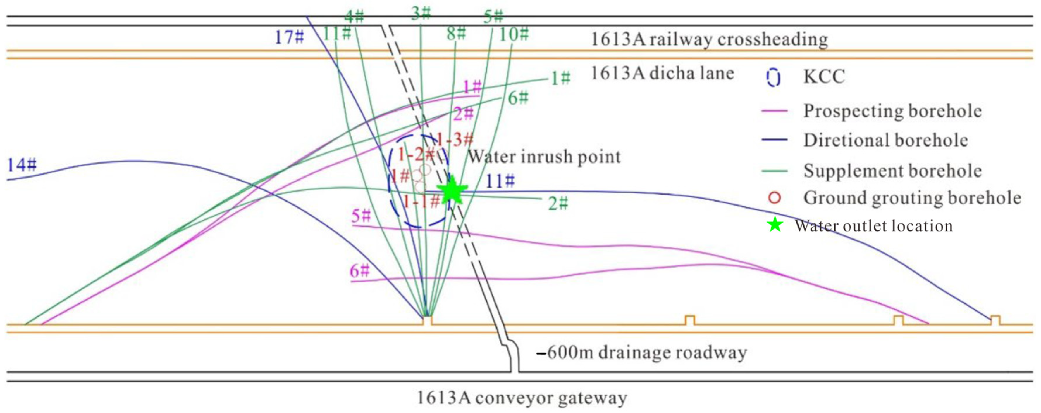
To ensure safe excavation in the West-3 panel, exploration of limestone water hazards, such as geophysical prospecting and directional long drilling (
Figure 3), was carried out to consolidate the strata between the coal seam and the limestone roof. When the 11# directional drilling was drilled to approximately 330 m, where the C
33down aquifer was located, water outflow began to appear. As the drill length increased to 344 m, the water yield increased by 15 m
3/h. After all drill rods were pulled out, the outflow water characteristics were as follows: water yield of 220 m
3/h, water temperature of 40.5 °C, and water pressure of 5.9 MPa, all higher than usual. To identify the water inrush source, water samples were collected and sent to the laboratory for testing. The results showed that the water originated from the Ordovician limestone aquifer.
Geophysical prospecting and drilling exploration were carried out to ascertain the characteristics of the water-conducting channel of the KCC in the 1613A stope. The distribution of KCC was preliminarily determined by prospecting boreholes (1#, 2#, 5#, etc.) and two directional boreholes (11# and 17#), as shown in
Figure 3. These boreholes essentially identified the spatial development range of the KCC. The investigation showed that the KCC is approximately elliptical, with a length of 53 m and a width of 35 m in plan view. The vertical development extends from the C
33down down to the Ordovician limestone aquifers.
From secondary fine interpretation of ground three-dimensional seismic data, it was also judged that a water-abundance zone and geological structures were developed near the outlet point. As can be seen from the slice along the bottom boundary of the limestone, the northern part of the outlet point is adjacent to an elliptical area with maximum negative curvature, and the anomaly of the minimum coherence attribute presents an “X”-shaped strip intersection, suspected to be a conjugate shear fault. The fragmentation and fracturing of the strata below the coal seam floor were thus established.
3.2. Grouting Treatment of the KCC
After grouting the prospecting boreholes and directional boreholes, the fractured zone was largely filled with slurry. Ten supplementary boreholes in the −600 m drainage roadway were then drilled to further fill the water-conducting fractures.
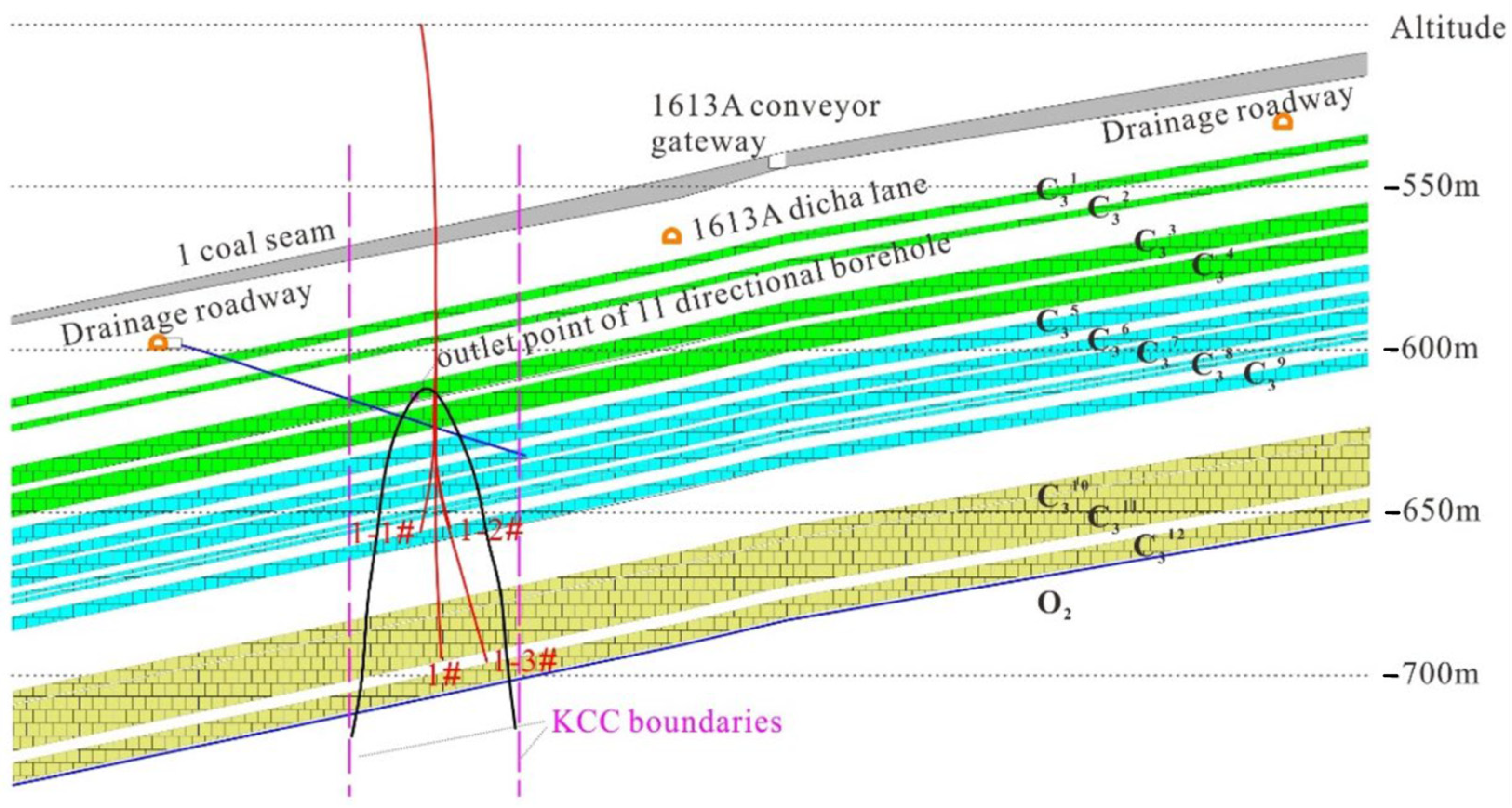
Meanwhile, ground multi-branch grouting boreholes were designed to consolidate the strata situated within the KCC. One main borehole (1#) and three branch boreholes (1-1#,1-2# and 1-3#) were positioned at a spacing of 30 m based on previous studies and the geological conditions of the mining area. The target layers between the C
33down aquifer and C
311 aquifer were selected for engineering implementation, as shown in
Figure 4. The grouting pressure was set to exceed 1.5 times the pressure of the limestone aquifers; the actual maximum grouting pressures for the three boreholes complied with the initial design. The desired treatment effect for the KCC was that the water yield of the drainage borehole would be less than 5.0 m
3/h.
4. Effect Evaluation of Treatment on KCC
4.1. Exploration and Analysis of Water-Abundance Zones
Drilling and geophysical exploration were combined to verify the overall treatment effect of the collapse column [
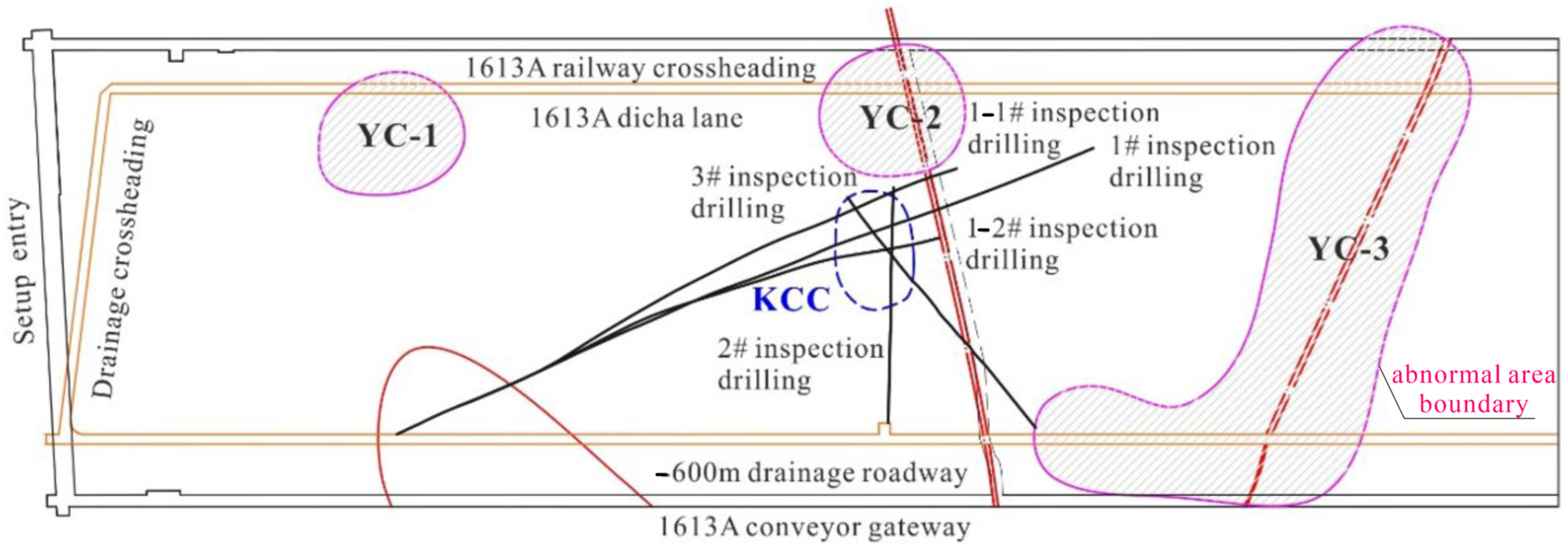
43]. The verification process generally consists of two stages. Comprehensive geophysical exploration is first used to investigate the distribution of water-abundance zones, targeting anomalous areas. Then, drilling exploration further validates the results of the previous geophysical survey. The transient electromagnetic method and the radio penetration method were applied to assess the water abundance of the limestone beneath the coal seam. The survey revealed three anomalous areas (YC-1 to YC-3) distributed within the inner section of the 1613A stope. The degree of water abundance is ranked as follows: YC-2 < YC-1 < YC-3. As shown in
Figure 5, YC-1 and YC-3 are far from the detected KCC; only YC-2 is located near KCC, which may pose a threat to stope excavation.
During the early excavation of the 1613A dicha roadway and −600 m drainage roadway, a group of circular exploration boreholes was drilled with an advance of 50 m each time. These boreholes roughly determined the water-abundance range of the three anomalous areas. The phenomenon was that abnormal outflow water yield, high water temperature, and high water pressure rarely occurred.
After geophysical exploration, further verification tasks for the grouting effect and anomalous areas were carried out successively. Five verification inspection boreholes covering the entire scale of the KCC were drilled from the −600 m drainage roadway to examine the grouting treatment effect, as shown in
Figure 5. Specific data from the five inspection boreholes were acquired and analyzed in depth. Except for inspection borehole 1#, which exhibited a water pressure of 4.2 MPa, a water yield of 23 m
3/h, and a water temperature of 50 °C, very little water flowed out of the other boreholes.
Although the effect of KCC treatment had been preliminarily verified by geophysical prospecting and drilling, the verification result of inspection borehole 1# indicated that the ground multi-branch grouting might not have completely filled all the fractures in the collapse column. Therefore, the five inspection boreholes were sealed by grouting to consolidate the fractured strata, with a cumulative grouting amount of approximately 125 tons.
After underground grouting, secondary validation of the KCC treatment was performed by drilling ten supplementary boreholes from the −600 m drainage roadway. During drilling, except for supplementary boreholes 5#, 8#, 9#, and 10#, no water was encountered in the other boreholes. The water inflow of supplementary borehole 5# was 1.5 m3/h, borehole 8# was 2.0 m3/h, borehole 9# was 1.5 m3/h, and borehole 10# was 0.5 m3/h, with a total water inflow of less than 6.0 m3/h. High water temperature was observed in supplementary boreholes 8# and 9#, which was mainly attributed to the exothermic effect of the grouting cement. The water inflow of these boreholes showed a decreasing trend over time, and eventually no water came from the boreholes. Thus, the treatment effect was confirmed, confirming that water-conducting fractures were blocked.
4.2. Water Inrush Coefficient and Safety Evaluation
The surface grouting treatment, combined with multiple periods of underground supplementary grouting and underground drainage depressurization, collectively eliminated the risk of Ordovician limestone water bursting along the water-conducting channel. Based on the water level data in the Ordovician limestone observation wells and the exploration data from geological boreholes in the mining area, the Ordovician limestone water inrush coefficient was calculated in accordance with the Coal Mine Prevention and Control Rule [
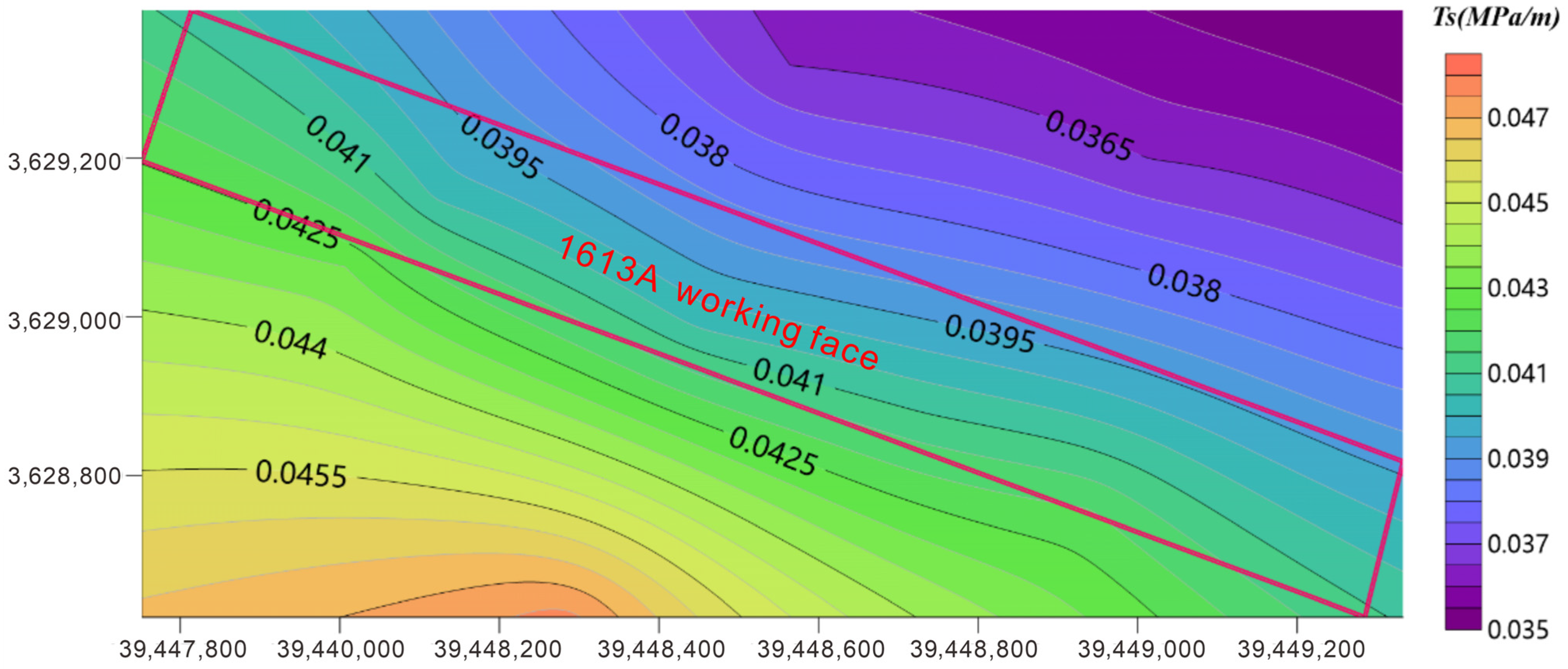
44]. In
Figure 6, it is evident that the maximum water inrush coefficient is less than 0.0425 MPa/m across the entire stope. Notably, the water inrush coefficient near the KCC ranges from 0.040 to 0.0405 MPa/m.
According to relevant standards, the water inrush coefficient should not exceed 0.06 MPa/m if the rock floor is damaged by geological structures, and should be less than 0.10 MPa/m under normal conditions without fractured structures. Considering that the No. 1 coal seam floor has been consolidated by multiple grouting operations, the floor’s water-resistant rock layers can be treated as intact strata. The water inrush coefficient in the study area is controlled below 0.0425 MPa/m, which is lower than the critical safety values of 0.06 MPa/m (for fractured strata) and 0.1 MPa/m (for intact strata) specified in the relevant standards [
45]. After grouting reinforcement, the integrity of the floor aquiclude is improved, so the current value meets the safe mining requirements. Based on the above-mentioned evidence, it can be concluded that the potential risk of water bursting from the KCC has been essentially eliminated.
5. Numerical Simulation of Groundwater Spatiotemporal Evolution
Due to the limited observation data during the stope period, the dynamic change trend of the karst aquifer throughout the drainage process cannot be fully described. To determine the dynamic change law of water pressure and water level in the karst aquifer during drainage, and to predict the characteristics of the groundwater flow field during mining, this study employed a finite element numerical simulation method to analyze groundwater changes in time and space. FEFLOW, a numerical simulation software widely used in groundwater movement, was applied to describe the details of hydraulic head and water pressure at different stages [
46,
47].
5.1. Geological Modeling and Simulation Conditions
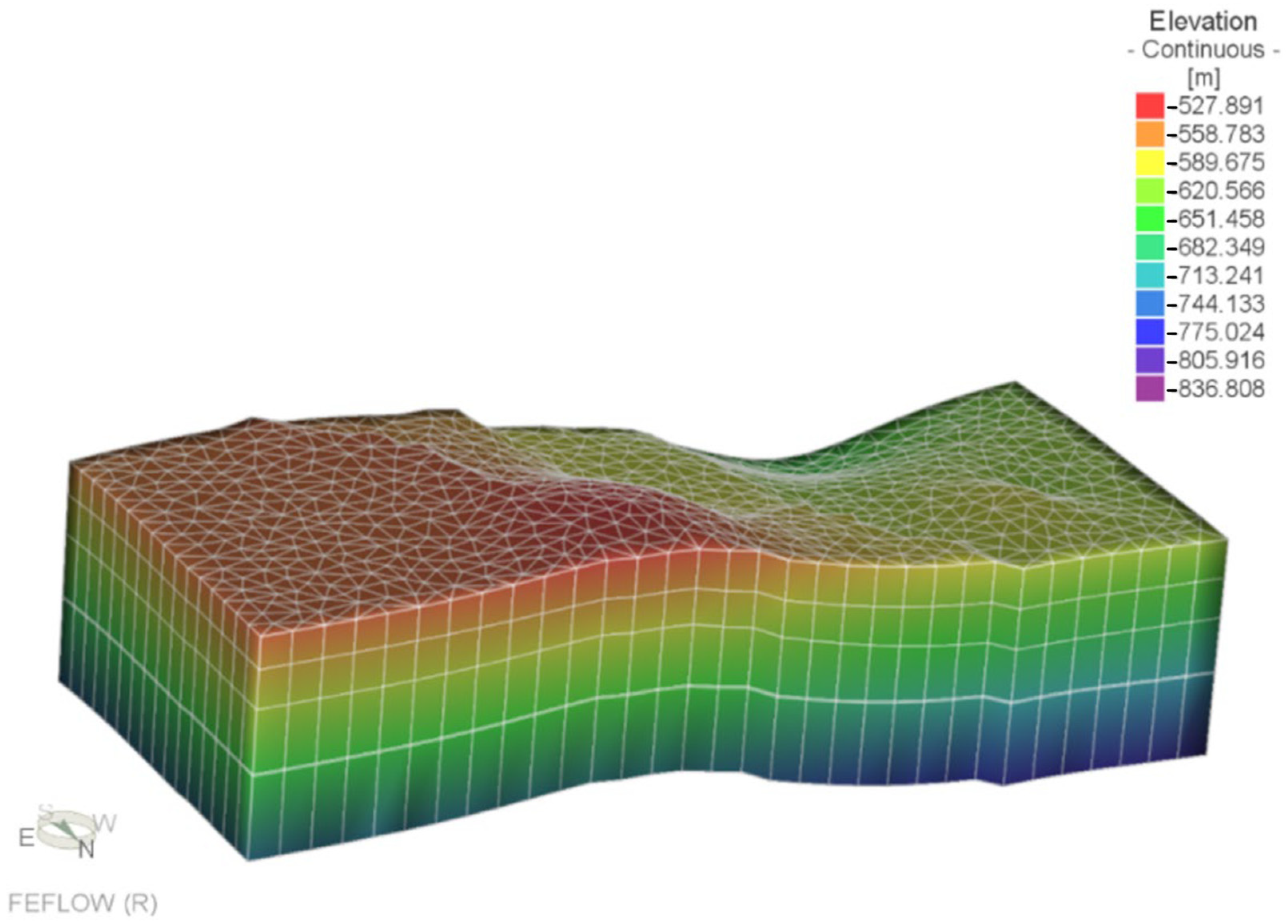
Based on extensive geological exploration borehole data and exploration profiles from the previous period, a three-dimensional geological model of the study area was established, as shown in
Figure 7. This study focuses on karst aquifers beneath the coal seam floor. The limestone strata were divided into six slices, representing five layers: the C
3I, C
3II, and C
3III limestone aquifers; an aquiclude; and the Ordovician limestone aquifer. The aquiclude distributed between the C
3III aquifer and the Ordovician aquifers is characterized by thin mudstone with a thickness of 1.4 m. The simulated study area covers the 1612A stope, 1613A stope, and 1615A stope. From the interpolation results of strata elevation, the elevation of limestone strata in the middle and eastern parts of the mining area is higher than that in the western area, but the elevation change is gentle.
In this study, the initial simulation period begins on 1 July 2023, before drainage and KCC treatment. The time step is set to 30 days, and the final simulation time is 1 July 2025. The study area is an open hydrogeological system with steady lateral groundwater recharge from adjacent regions. Therefore, Neumann (second-type) boundary conditions with specified flux were adopted. The specified flux was st to 0.024 m/d based on regional hydrogeological conditions. Permeability coefficients and specific storage values were determined from pumping tests and empirical values, then interpolated and optimized in the model. Drainage boreholes, which induce water quantity changes, were generalized as water loss and assigned to each aquifer node on average.
Three surface observation wells for water level monitoring were selected to validate and assess the simulation results. The three selected boreholes are the West Ventilation Shaft C3II, west ventilation shaft C3III, and west ventilation shaft O2. Water-conducting fractures beneath the No. 1 coal seam floor were sealed by ground grouting, and underground limestone water drainage may have a certain impact on the water levels of the Taiyuan Formation limestone aquifers and the Ordovician aquifer.
5.2. Initial Flow Field
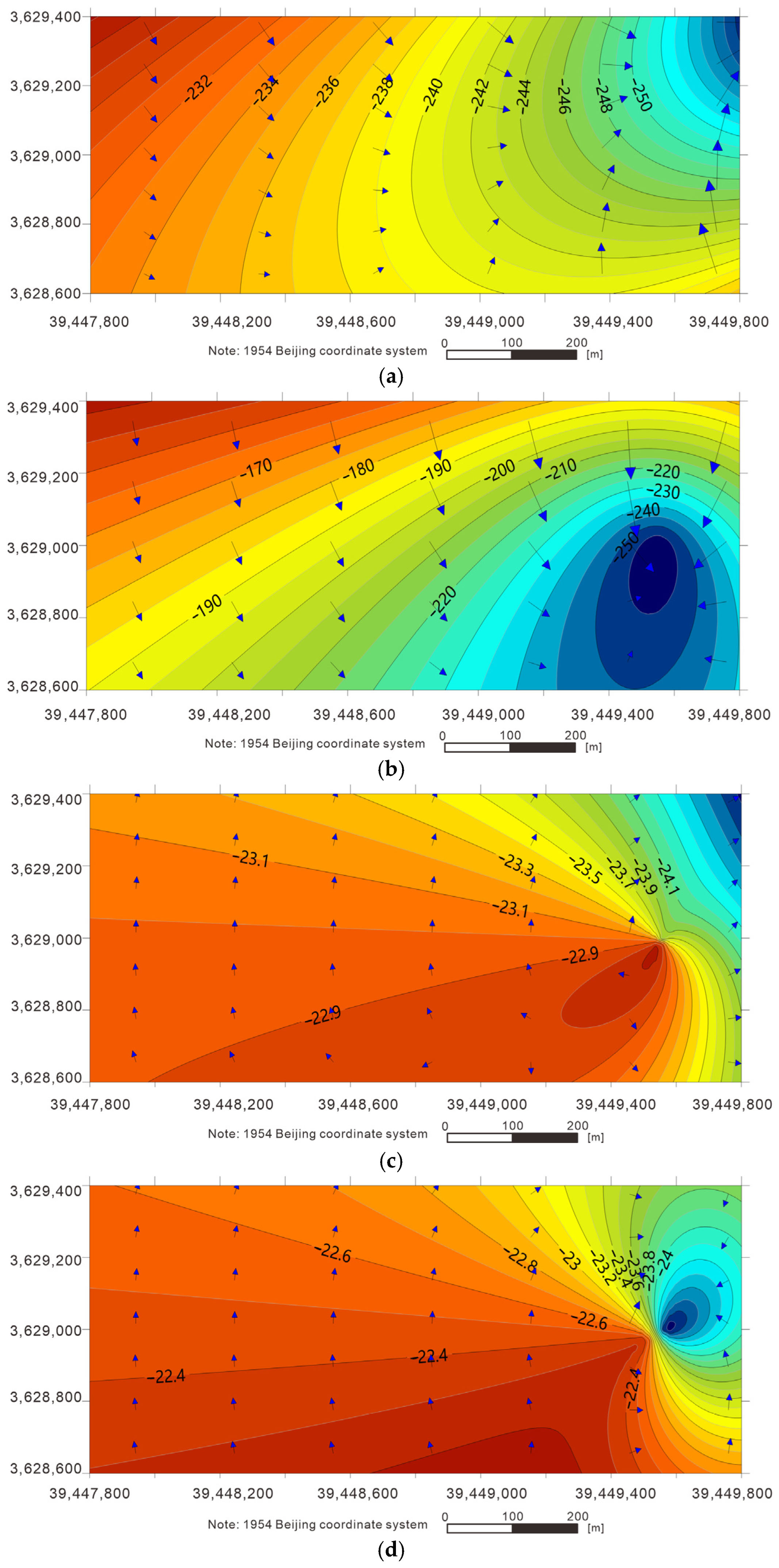
To understand the dynamic change of the flow field in the limestone aquifers, it is necessary to obtain the initial flow field of the study area. The initial simulation was set at 1 July 2023, at which time surface water level observation data were used to describe the water flow field characteristics of each aquifer, as shown in
Figure 8. The water level ranges for each aquifer are as follows: C
3I aquifer: −226 to −260 m; C
3II aquifer: −145 to −260 m; C
3III aquifer: −22.6 to −24.9 m; Ordovician aquifers: −22.1 to −24.8 m.
The flow fields of the limestone aquifers can be divided into two types. The first type includes the C3I and C3II aquifers, characterized by groundwater flow spreading from northwest to east. The second type includes the C3III and Ordovician aquifers, where the water level in the southeast is slightly higher than that in the northeast, and groundwater flow converges northeastward.
5.3. Hydrogeologic Parameters
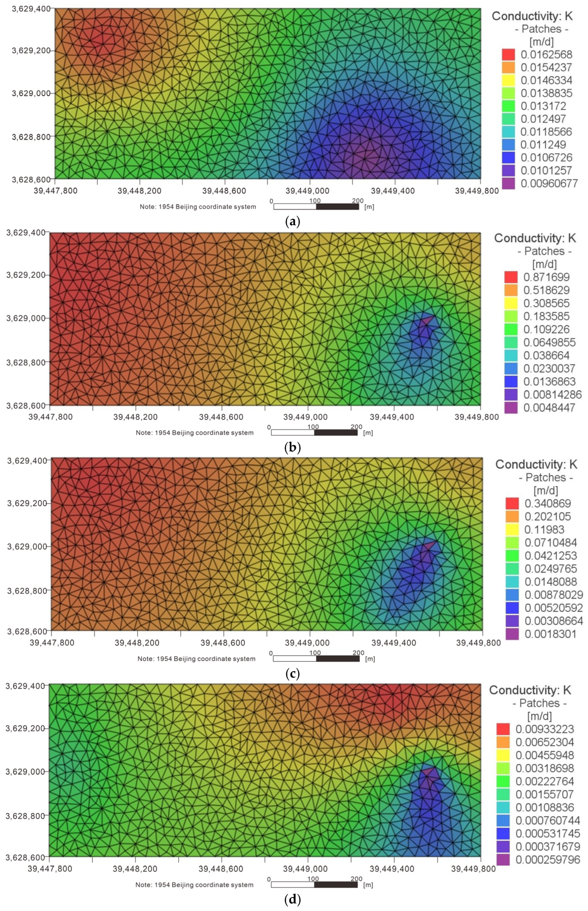
Hydrogeologic parameters, including permeability coefficient and specific storage, were defined for the study. Permeability coefficient data for each aquifer were obtained from previous pumping tests, and the limited data were interpolated to generate the permeability coefficient distribution for the study area. The heterogeneity of pores in the Ordovician limestone aquifer leads to a wide range of permeability coefficients. The permeability coefficients of limestone aquifers measured during pumping tests are shown in
Table 2. The limestone aquifers were assumed to be idealized isotropic media in this study.
Because only a few boreholes exist in the study area, the above data were interpolated using Surfer software to obtain interpolation data within the study area. Then, the interpolation method built into FEFLOW was used for further processing, and the permeability coefficient distribution map for each aquifer was finally generated, as shown in
Figure 9.
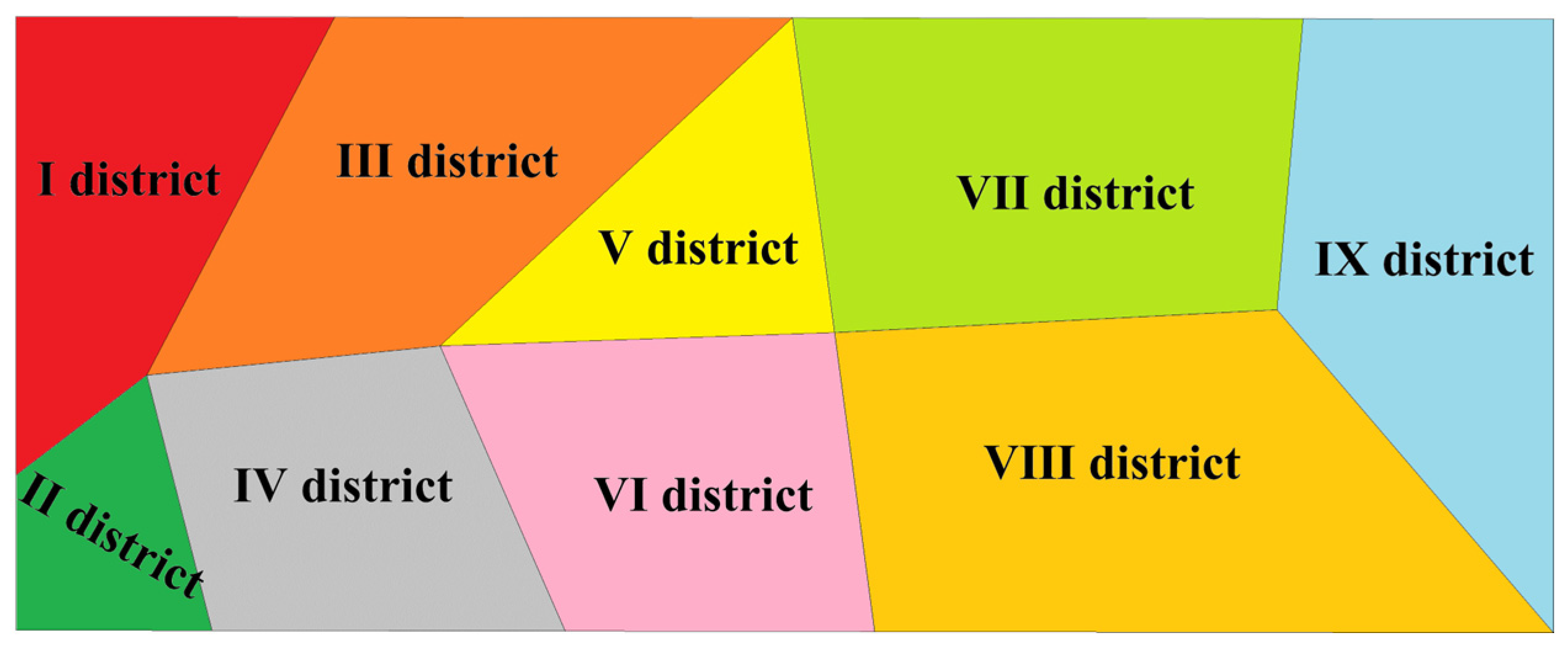
Given the lack of specific storage data, the specific storage was simplified by dividing the area into nine districts, as shown in
Figure 10. Different specific storage values were assigned to the nine districts based on previous studies and empirical reference values. The final values were determined after repeated adjustments.
5.4. Simulation Results and Effect Evaluation
Manual adjustment was conducted iteratively to minimize the deviation between simulated and observed water levels. The simulation accuracy was quantitatively evaluated using the root mean square error (RMSE), average relative error (RE), and correlation coefficient (R2). Calibration was completed when the errors reached a reasonable range and the fitting degree was satisfactory. This ensured that the model was reliable and representative of the actual hydrogeological conditions.
Three observation wells monitoring water level (C
3II, C
3III, and O
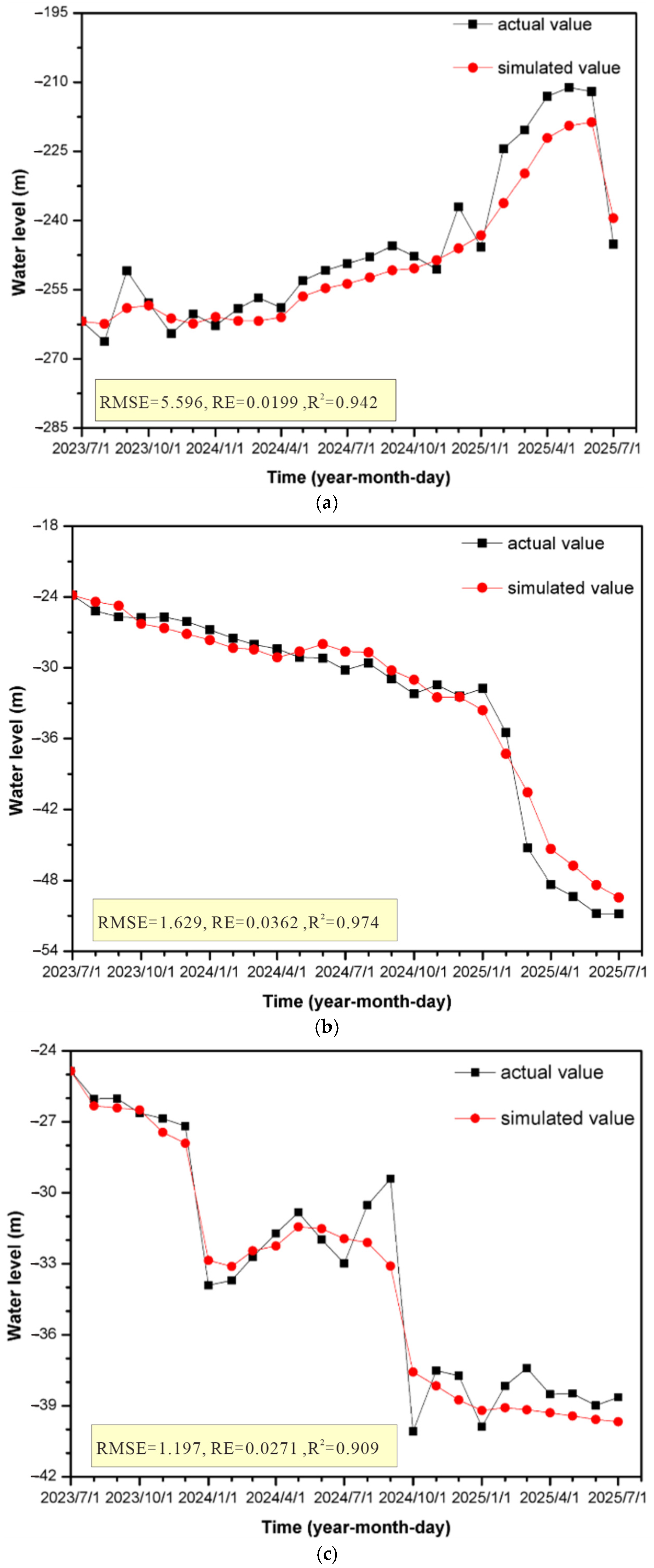
2) were used for calibration. Predicted water level of observation wells in the study area were obtained after simulation, and actual water level data were obtained from daily dynamic monitoring. The two sets of water level data at the same time were compared to evaluate the numerical model. As shown in
Figure 11, a fitting curve relationship between the actual water level and the simulated water level was established. Owing to the lack of C
3I aquifer observation wells in the mining area, only the water levels of C
3II, C
3III, and O
2 limestone aquifers were fitted and analyzed in this study.
The accuracy of the simulation results was evaluated by comparing simulated and measured water levels. Quantitative assessment was conducted using RMSE, RE, and R2. The calculated results show that the maximum RMSE and RE are 5.596 and 0.0363, respectively, while the minimum R2 is 0.909. The small RE and the high R2 value indicate that the model captures the overall water level dynamics well and that the systematic bias is modest relative to the observed drawdown range. For the purpose of engineering safety evaluation, where the key concern is whether the post-treatment water inrush coefficient falls below the safety threshold, the attained accuracy is considered adequate. We note that visible deviations between simulated and measured water levels exist in some periods (e.g., early drainage of C3II and late recovery of O2). Possible causes include limited monitoring frequency, spatial heterogeneity of hydraulic properties, unsteady drainage fluctuations, and simplified model assumptions (e.g., isotropic media, constant node assignments). These factors may contribute to local discrepancies, but the overall model performance remains acceptable for the purpose of engineering safety evaluation. Thus, the simulation results are deemed reliable for supporting the assessment of grouting treatment.
Although a full quantitative sensitivity analysis is beyond the scope of this study, we qualitatively assessed the influence of parameter uncertainty on simulation results. Based on typical ranges for limestone aquifers in the Huainan area (permeability coefficient variation within ±20%, specific storage variation within ±20%), the simulated water level changes by less than 2% of the total drawdown when the Ordovician permeability coefficient is varied by ±20%. This is because the overall flow regime is dominated by continuous drainage from multiple boreholes, which buffers local parameter variations. Therefore, the model conclusions are considered robust for engineering purposes. It should be noted that a full quantitative sensitivity analysis and rigorous uncertainty quantification were not conducted in this study. The above uncertainty discussion remains largely qualitative and serves primarily to assess the robustness of the model conclusions for engineering purposes. Future studies will incorporate formal sensitivity analysis and more systematic uncertainty quantification to further constrain the model predictions.
6. Discussion
To reduce the water pressure of the karst limestone aquifers, thereby preventing a high hydraulic head from acting on the lower three zones under mining disturbance, especially near the collapse column, 22 directional long boreholes and 6 conventional boreholes were drilled to cover the entire stope. When the boreholes were drilled into the target layer, outflow occurred only in boreholes 10#, 11#, 14#, 20#, L3-1#, L3-3# and L4-1# to L4-3#. Before grouting treatment, the 11# directional borehole passed through the KCC, so its initial water yield was larger than that of the other boreholes. The initial water pressure and outflow of the 11# borehole were approximately 5.8 MPa and 220 m3/h, respectively; both decreased significantly after continuous dewatering and grouting.
After artificial drainage, only boreholes 1#, 4#, 9#, 10#, 21#, and L3-1# continued to discharge water, with flow rates ranging from 0.1 to 3.0 m3/h. The maximum water pressure observed is 0.3 MPa in borehole 21#, indicating that groundwater levels have declined to safe levels.
The integrated workflow proposed in this study, including comprehensive detection, surface–underground combined grouting, and multi-index effect evaluation, is not limited to the geological conditions of the Zhangji coal mine. This method can be extended and adapted to other mining areas with different hydrogeological characteristics. For Northern China coal mines with developed faults, strong water abundance, or greater mining depth, the detection layout, grouting parameters, and evaluation indicators can be adjusted accordingly. Thus, the technical scheme can serve as an important reference for water hazard control for karst collapse columns in similar coal mines. However, the applicability may be further tested under different hydrogeological conditions. Although some expected results have been obtained, several limitations should be acknowledged. For example, numerical model validation relies on a limited number of observation wells, which may introduce minor uncertainties in parameter calibration and regional water level prediction. Future research will focus on optimizing the monitoring network to enrich observation data and improve model accuracy.
From this case study, we extract the following transferable lessons for similar coal mines facing KCC hazards:
- (1)
Detection design: A combination of surface 3D seismic surveying and underground directional drilling with at least two boreholes crossing the suspected KCC is recommended to delineate its spatial extent.
- (2)
Grouting parameters: The rule-of-thumb grouting pressure (≥1.5 times the aquifer pressure) proved effective in this setting. For deeper mines (>800 m) or highly fractured strata, a higher factor (up to 2.0) may be necessary.
- (3)
Verification metrics and thresholds: A multi-index closed-loop system (geophysics + borehole inflow + water inrush coefficient + numerical simulation) is strongly recommended. The water inrush coefficient is the most quantitative metric.
- (4)
Decision framework: A step-by-step decision framework includes: initial detection → grouting design (pressure, volume, target zones) → post-grouting verification (multi-index) → long-term monitoring and risk reassessment. This framework can be adapted to other coal mines with similar hydrogeological settings by adjusting parameters based on local conditions.
A brief failure-mode analysis was conducted. Potential residual risks after grouting include (i) incomplete filling of micro-fractures that may gradually erode under hydraulic pressure, (ii) long-term chemical degradation of the cement grout, and (iii) new fracturing induced by mining disturbances. To mitigate these risks, we recommend continuous pressure monitoring in the O2 aquifer (at least bi-weekly) and annual borehole video inspections for the first three years post-treatment. If any abnormal pressure increase or water inflow is detected, remedial grouting should be considered. These measures are not yet implemented in the current study but are proposed for future practice.
7. Conclusions
During conventional exploration of water hazards in the Taiyuan Formation limestone, the KCC was detected by directional drilling. Its shape is approximately elliptical, measuring 53 m in length and 35 m in width in plan view. Vertically, it extends from the Ordovician limestone to the C33down aquifer. A series of prevention and treatment measures, including multi-borehole drainage depressurization and grouting from both underground and surface, were implemented in the study area.
The effectiveness of the KCC treatment was subsequently validated through multiple stages and methods under the specific conditions of this case study. The results indicate that the immediate risk of water inrush from the KCC has been reduced to an acceptable level, although long-term monitoring is recommended to confirm sustained safety. The water inrush coefficient was calculated to be less than 0.0425 MPa/m across the entire stope, and between 0.040 and 0.0405 MPa/m near the KCC. Based on current data, this indicates that the grouting treatment for limestone water hazards has been effective under the hydrogeological conditions of the Zhangji coal mine.
Numerical simulation suggests that the water levels in limestone aquifers declined significantly during grouting. Based on the calibrated model, there is a high probability that the post-treatment water inrush coefficient will remain below the safety threshold of 0.06 MPa/m under normal mining conditions. However, as the observation period is relatively short (approximately two years), long-term monitoring is strongly recommended to verify this prediction. However, because the observation period is relatively short (approximately two years), long-term monitoring is strongly recommended to verify this prediction. A preliminary failure-mode analysis is provided in the Discussion section, and continuous monitoring is advised to detect any delayed changes in hydraulic conductivity.
Author Contributions
Conceptualization, Y.L. and Q.L.; methodology, J.Z.; software, J.Z.; validation, Q.L.; formal analysis, Y.L. and C.L.; investigation, Y.L. and Q.L.; resources, Q.L.; data curation, C.L.; writing—original draft preparation, Y.L. and J.Z.; writing—review and editing, J.L. and J.Z.; supervision, C.L.; project administration, Q.L.; funding acquisition, Y.L. and Q.L. All authors have read and agreed to the published version of the manuscript.
Funding
This research was funded by the Natural Science Research Project of Anhui Educational Committee (Grant No. 2022AH050797), the Deep Earth Probe and Mineral Resources Exploration—National Science and Technology Major Project (Grant No. 2024ZD1004200), the Open Foundation of the Key Laboratory of Universities in Anhui Province for Prevention of Mine Geological Disasters (Grant No. 2022-MGDP-01), the Open Research Grant of Joint National-Local Engineering Research Centre for Safe and Precise Coal Mining (Grant No. EC2023012), and the Open Foundation of the National Engineering Research Center of Coal Mine Water Hazard Controlling (WBMDGCZXJJ 2025-6).
Data Availability Statement
The original contributions presented in this study are included in the article. Further inquiries can be directed to the corresponding author.
Conflicts of Interest
The authors declare no conflicts of interest.
References
- Liu, C.; Zhang, X.P.; Qiao, W. Numerical studies on mine water inrush mechanism due to a large hidden karst collapse column investigation. Int. J. Mine Water Environ. 2025, 44, 847–860. [Google Scholar] [CrossRef] [Scilit]
- Liu, Y.; Ji, M.; Wang, Y.; Liu, G.N.; Gu, P.X.; Wang, Q.Y. Fractal mechanical model of variable mass seepage in karst collapse column of mine. Phys. Fluids 2024, 36, 022031. [Google Scholar] [CrossRef] [Scilit]
- Xu, Z.M.; Sun, Y.J.; Gao, S.; Chen, H.Y.; Yao, M.H.; Li, X. Comprehensive exploration, safety evaluation and grouting of karst collapse columns in the Yangjian coalmine of the Shanxi province, China. Carbonates Evaporites 2021, 36, 16. [Google Scholar] [CrossRef] [Scilit]
- Zuo, J.P.; Peng, S.P.; Li, Y.J.; Chen, Z.H.; Xie, H.P. Investigation of karst collapse based on 3-D seismic technique and DDA method at Xieqiao coal mine, China. Int. J. Coal Geol. 2009, 78, 276–287. [Google Scholar] [CrossRef] [Scilit]
- Xue, Y.; Teng, T.; Zhu, L.; He, M.M.; Ren, J.; Dong, X.; Liu, F. Evaluation of the non-darcy effect of water inrush from karst collapse columns by means of a nonlinear flow model. Water 2018, 10, 1234. [Google Scholar] [CrossRef] [Scilit]
- Liu, Y.; Zhu, J.Z.; Liu, Q.M.; Yuan, A.Y.; He, S.F.; Bai, Y.S. Mechanism analysis of delayed water inrush from karst collapse column during roadway excavation based on seepage transition theory: A case study in Paner coal mine. Energies 2022, 15, 4987. [Google Scholar] [CrossRef] [Scilit]
- Liu, Z.X.; Dong, S.N. Damage water inrush mechanism of loading unloading stress path of mining floor in deep coal seam. Sci. Rep. 2024, 15, 24283. [Google Scholar]
- Liu, T.; Han, M.K.; Zhao, J.Y. Prediction of Floor Failure Depth Based on Dividing Deep and Shallow Mining for Risk Assessment of Mine Water Inrush. Water 2024, 16, 2786. [Google Scholar] [CrossRef] [Scilit]
- Zhou, W.F. The formation of sinkholes in karst mining areas in China and some methods of prevention. Environ. Geol. 1997, 31, 50–58. [Google Scholar] [CrossRef] [Scilit]
- Liang, H.; He, S.M.; Chen, Z.; Liu, W. Modified two-phase dilatancy SPH model for saturated sand column collapse simulations. Eng. Geol. 2019, 260, 105219. [Google Scholar] [CrossRef] [Scilit]
- Islam, N.; Xu, L.R.; Usman, A.B.; Raza, B.; Li, Y.W.; Li, S.X. Study on field and numerical analysis of karst collapse as railway hazard. Proc. Inst. Civ. Eng.-Geotech. Eng. 2025, 178, 324–338. [Google Scholar] [CrossRef] [Scilit]
- Zuo, J.P.; Hong, Z.J.; Peng, S.P.; Shi, Y.; Song, H.Q.; Li, M.; Zhang, Z.S. Investigation on failure behavior of collapse column in China’s coal mine based on discontinuous deformation numerical method. PLoS ONE 2019, 14, 0219733. [Google Scholar] [CrossRef] [Scilit]
- Intrieri, E.; Gigli, G.; Nocentini, M.; Lombardi, L.; Mugnai, F.; Fidolini, F.; Casagli, N. Sinkhole monitoring and early warning: An experimental and successful GB-InSAR application. Geomorphology 2015, 241, 304–314. [Google Scholar] [CrossRef] [Scilit]
- Zhang, H.T.; Xu, G.Q.; Zhan, H.B.; Zhen, J.B.; Wang, M.H.; Pan, S.Q.; Wang, N. Formation mechanisms of paleokarst and karst collapse columns of the Middle Cambrian-Lower Ordovician carbonates in Huainan coalfield, Northern China. J. Hydrol. 2021, 601, 126634. [Google Scholar] [CrossRef] [Scilit]
- Chen, Z.B.; Zhao, Z.Y.; Gao, J.R.; Zhang, Y.B.; Xu, W.L.; Bai, Y.; Zhang, Y.Q.; Lai, Y.T.; Wang, C. Features of karst paleogeomorphology and sedimentary environment of Ordovician majiagou formation in eastern Ordos basin. ACS Omega 2025, 10, 10601–10616. [Google Scholar] [CrossRef] [Scilit]
- Kouassi, A.K.F.; Pan, L.; Wang, X.; Wang, Z.H.; Mulashani, A.K.; James, F.; Shaame, M.; Hussain, A.; Hussain, H.; Nyakilla, E.E. Identification of karst cavities from 2D seismic wave impedance images based on cradient-boosting decision trees algorithms (GBDT): Case of Ordovician fracture-vuggy carbonate reservoir, Tahe oilfield, Tarim basin, China. Energies 2023, 16, 643. [Google Scholar] [CrossRef] [Scilit]
- Li, G.Y.; Zhou, W.F. Impact of karst water on coal mining in North China. Environ. Geol. 2006, 49, 449–457. [Google Scholar] [CrossRef] [Scilit]
- Li, H.; Bai, H.B.; Wu, J.J.; Zhao, H.M.; Ma, K. A method for prevent water inrush from karst collapse column: A case study from Sima mine, China. Environ. Earth Sci. 2017, 76, 493. [Google Scholar] [CrossRef] [Scilit]
- Wang, T.H.; Wang, X.W.; Zhang, X.; Luo, L.; Liu, H.Y. Characteristics of karst geothermal system in intermountain fault basin: A case study of Taiyuan basin in north China. Front. Earth Sci. 2026, 13, 1661628. [Google Scholar] [CrossRef] [Scilit]
- Jiang, X.Z.; Dai, J.L.; Zheng, Z.W.; Li, X.J.; Ma, X.; Zhou, W.F.; Lei, Q.Q. An overview on karst collapse mechanism in China. Carbonates Evaporites 2024, 39, 71. [Google Scholar] [CrossRef] [Scilit]
- Lu, C.J.; Chai, J.C.; Xu, J.P.; Li, P.; Bian, K. The discovery of water conduction in karst collapsed column caused by fault cutting: Evidence from chronology, exploration data and hydrochemical test. Acta Geol. Sin.-Engl. Ed. 2025, 99, 272–283. [Google Scholar] [CrossRef] [Scilit]
- Li, M.D.; Li, Y.P.; Zhong, T.F.; Lang, Q.L.; Zhou, J. Near-fault ground motions induced dynamic responses and failure mechanisms of tunnels considering seismic-karst coupling effects. Bull. Eng. Geol. Environ. 2026, 85, 222. [Google Scholar] [CrossRef] [Scilit]
- Yin, S.X.; Lian, H.Q.; Liu, D.M.; Yin, H.C. 70 years of investigation on karst collapse column in North China Coalfield: Cause of origin, mechanism and prevention. Coal Sci. Technol. 2019, 47, 1–29. [Google Scholar]
- Wei, X.D.; Liu, Y.; Li, X.X.; Lu, Y.L. Application of high density resistivity method in karst exploration: A case study. Teh. Vjesn. 2023, 30, 1283–1291. [Google Scholar]
- Liu, B.; Liu, Z.Y.; Li, S.C.; Nie, L.C.; Su, M.X.; Sun, H.F.; Fan, K.R.; Zhang, X.X.; Pang, Y.H. Comprehensive surface geophysi-cal investigation of karst caves ahead of the tunnel face: A case study in the Xiaoheyan section of the water supply project from Songhua River, Jilin, China. J. Appl. Geophys. 2017, 144, 37–49. [Google Scholar]
- Fu, Z.; Kang, J.; Qiu, D.W. In situ measurement of water accumulation in overlying goaf of coal mine-a transient electro-magnetic-based study. Arab. J. Geosci. 2021, 14, 406. [Google Scholar] [CrossRef] [Scilit]
- Wang, P.; Wang, Q.; Wang, Y.; Wang, C. Detection of abandoned coal mine goaf in China’s Ordos basin using the transient electromagnetic method. Mine Water Environ. 2021, 40, 415–425. [Google Scholar] [CrossRef] [Scilit]
- Teng, J.W.; Li, S.Y.; Jia, M.K.; Lian, J.; Liu, H.L.; Liu, G.D.; Wang, W.; Volker, S.; Feng, L.; Yao, X.S.; et al. Research and application of in-seam seismic survey technology for disaster-causing potential geology anoma-lous body in coal seam. Acta Geol. Sin. 2020, 94, 10–26. [Google Scholar] [CrossRef] [Scilit]
- Xiao, G.H.; Lu, H.F. Study on the hydrochemical characteristics and evolution law of Taiyuan formation limestone water under the influence of grouting with fly ash cement: A case study in Gubei coal mine of Huainan, China. Water 2024, 16, 971. [Google Scholar] [CrossRef] [Scilit]
- Yu, X.G.; Wang, S.C.; Su, B.C.; Zhang, W.Q. Exploration and prediction of high pressure dynamic water hidden collapse column in coal mines. Water Resour. Ind. 2024, 31, 100250. [Google Scholar] [CrossRef] [Scilit]
- Wu, S.Z.; Lin, Z.C.; Cai, J.M.; Xing, C.; Qi, F.M.; Wang, Z.K. Case study on the uplift of tunnel segments due to grouting layer deterioration during shield tunnel operation in karst fissure development strata. Case Stud. Constr. Mater. 2025, 22, e04553. [Google Scholar] [CrossRef] [Scilit]
- Hubbert, M.K. The theory of ground-water motion. J. Geol. 1940, 48, 785–944. [Google Scholar] [CrossRef] [Scilit] [PubMed]
- Tóth, J. A theoretical analysis of groundwater flow in small drainage basins. J. Geophys. Res. 1963, 68, 4795–4812. [Google Scholar] [CrossRef] [Scilit]
- Bear, J. Dynamics of Fluids in Porous Media; American Elsevier Publishing Company: New York, NY, USA, 1972. [Google Scholar]
- White, W.B. Geomorphology and Hydrology of Karst Terrains; Oxford University Press: New York, NY, USA, 1988. [Google Scholar]
- Milanović, P.T. Karst Hydrogeology; Water Resources Publications: Littleton, CO, USA, 1981. [Google Scholar]
- Dreiss, S.J. Regional scale transport in a karst aquifer: 1. Component separation of spring flow hydrographs. Water Resour. Res. 1989, 25, 117–125. [Google Scholar] [CrossRef] [Scilit]
- Konikow, L.F.; Bredehoeft, J.D. Ground-water models cannot be validated. Adv. Water Resour. 1992, 15, 75–83. [Google Scholar] [CrossRef] [Scilit]
- Anderson, M.P.; Woessner, W.W. Applied Groundwater Modeling: Simulation of Flow and Advective Transport; Academic Press: New York, NY, USA, 1992. [Google Scholar]
- Yin, S.X.; Wang, S.X.; Wu, Q. Water inrush patterns and theoretic criteria of karstic collapse columns in North China coalfields. Chin. J. Rock Mech. Eng. 2004, 23, 2533–2540. [Google Scholar]
- Liu, Q.S. A discussion on water inrush coefficient. Coal Geol. Explor. 2009, 37, 34–37. [Google Scholar]
- Zhang, R.Q.; Liang, X.; Jin, M.G. Groundwater System Theory and Its Application; China University of Geosciences Press: Wuhan, China, 2018. [Google Scholar]
- Liu, B.; Dai, J.K.; Gu, H.; Gao, P.J.; Zhang, X. Progress in geological core drilling technology. Chem. Technol. Fuels Oils 2025, 61, 1309–1318. [Google Scholar] [CrossRef] [Scilit]
- Li, W.P.; Liu, Y.; Qiao, W.; Zhao, C.X.; Yang, D.D.; Guo, Q.C. An improved vulnerability assessment model for floor water bursting from a confined aquifer based on the water inrush coefficient method. Mine Water Environ. 2018, 37, 196–204. [Google Scholar] [CrossRef] [Scilit]
- Wu, Q.; Guo, X.; Shen, J.; Xu, S.; Liu, S.; Zeng, Y.F. Risk assessment of water inrush from aquifers underlying the Gushuyuan coal mine, China. Mine Water Environ. 2017, 36, 96–103. [Google Scholar] [CrossRef] [Scilit]
- Hou, Z.M.; Huang, L.; Zhang, S.W.; Han, X.; Xu, J.; Li, Y.N. Identification of groundwater hydrogeochemistry and the hydraulic connections of aquifers in a complex coal mine. J. Hydrol. 2024, 628, 130496. [Google Scholar] [CrossRef] [Scilit]
- Cui, H.; Duan, L.M.; Pan, H.; Zhang, W.R.; Liu, T.X. How does large-scale underground mining affect the water cycle?—Comprehensive analysis based on isotopes, water levels and hydrogeological conditions. J. Environ. Manag. 2025, 393, 127188. [Google Scholar] [CrossRef] [Scilit] [PubMed]
| Disclaimer/Publisher’s Note: The statements, opinions and data contained in all publications are solely those of the individual author(s) and contributor(s) and not of MDPI and/or the editor(s). MDPI and/or the editor(s) disclaim responsibility for any injury to people or property resulting from any ideas, methods, instructions or products referred to in the content. |