The C2G Framework to Convert Infrastructure Data from Computer-Aided Design (CAD) to Geographic Information Systems (GIS)
Abstract
:1. Introduction
- Interview municipality employees to better understand the needs and difficulties they encounter;
- Propose a framework to guide the conversion;
- Demonstrate the framework through a case study.
2. Materials
2.1. Municpal Employees Interviews
“So [the engineers] go out and GPS the underground stuff, which is what they really want to know where it is. They take that and they bring it into CAD cause that’s what they’re familiar with. And then they shipped the CAD files over to us [the GIS Department] and we bring it into our GIS and also into our asset management system.”(Interview 005, 12 July 2018)
“So it’s for better accessibility for everybody else who’s in the municipality to access that data.”(Interview 004, 11 July 2018)
“The main benefit of converting [data] to GIS is you work with your asset management system. And retrieval is much easier for an online mapping.”(Interview 005, 12 July 2018)
“I think you realized that many cities struggle, us included, in terms of how to handle all of that information. There is a component of making interactive maps that’s becoming more prevalent and it’s nice to have that for some of the field work, but we still extensively make static maps, whether that’s in paper form or creating a PDF that’s going to go out to people and being able to do that. It’s difficult to in CAD, I know they can make some maps but they just don’t have the same accessibility in terms of being able to read them and get information off of them.”(Interview 011, 19 July 2018)
“I think the short-term goal is to get all the information that is in a few of the older employees’ heads and memories into the PC [personal computer] and GIS. So that when they leave, when they retire, that we’re not going to lose all that information.”(Interview 011, 19 July 2018)
2.2. Reported Challenges in the Conversion Process
“a lot of the prioritization comes from working with the engineering department in terms of what they have said that they want to look at in the future as well as working with our utilities department to see what attributes they’re interested in as well for maintenance and … what information is useful for them when they’re in the field.”(Interview 011, 19 July 2018)
“the old stuff, … the old pipes in the ground for a long time. When we originally collected the data, we had an intern go around with one of the older guys that [has] been there a while and he’d say, well this is a six inch and I think it’s AC and it was put in and the 60s, so it would get an install date of 1960. So, the older stuff was kind of 40, 50, 60, 70, until we really start to nail down when the actual installation day was. So that the problem was that they didn’t quite remember correctly and they say, I think it’s right here. So, we draw it in here and then they’d go to dig it up and starting digging sideways until they actually found it. So, the locations were off because the data wasn’t kept. And then … the sizes were different than what they thought they were. the pipes were occasionally different than what they thought they were also.”(Interview 005, 12 July 2018)
2.3. Solution Recommended
“We would have to … push it back onto developers where they would be responsible for providing the Autocad [files] and then they would also provide shapefiles, feature classes of what we’re interested in, and we would define what those are, and then they’d be providing all of that data input already and a geodatabase template that has domain feature classes all set up with all the data that we want them to fill in.”(Interview 011, 19 July 2018)
“If other cities would ask us for data, we would definitely share with them. They’re working on a project that shares borders on our boundary. That happens often—sharing data with other developers or engineering firms. And sharing that data via GIS and shapefiles or geodatabases work best rather than through CAD.”(Interview 011, 19 July 2018)
“Yes, we have had topology problems, especially when we started working with geometric networks. There’s all kinds of other issues that we’ve run into. They’ve tried a bunch of different things within CAD or engineering texts in terms of trying type network set of things and it’s just inconsistent for getting everything all linked together. So, there’s a certain amount of fixing that we will do. We’ll import that data and usually project my project so it’s not a huge extent of data. So, it will come in, we’ll ensure that it’s in the correct location. Sometimes they’ll have forgotten to correctly project the data, so we’ll have to send it back to them to get it projected in CAD and then we’ll import it to our GIS and we’ll look at it. And if it’s not hooking into our existing line networks, we’ll manually just attach it to the known networks, just to ensure that it’s kind of taking care of some of that stuff. So, it’s, inspected manually, but you know, it’s usually two or three spots where you have to connect it into existing networks.”(Interview 011, 19 July 2018)
3. Methods
3.1. C2G Conversion Framework
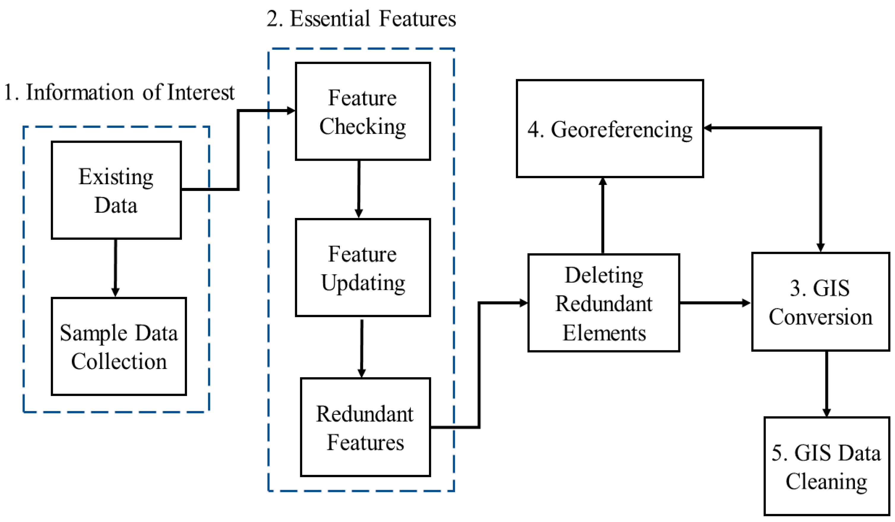
3.1.1. Information of Interest
3.1.2. Essential Features
3.1.3. GIS Conversion
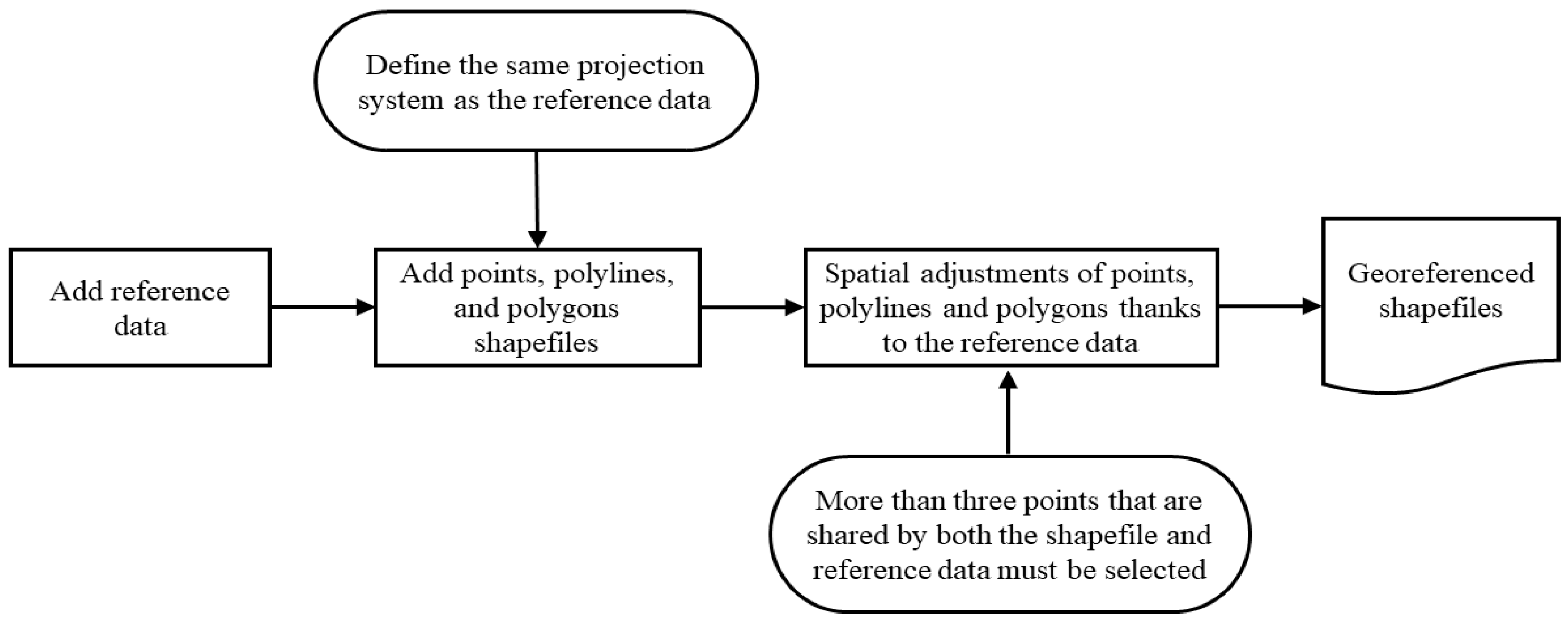
3.1.4. Georeferencing
3.1.5. GIS Data Cleaning
3.2. Common Problems
3.2.1. Texts in CAD Data
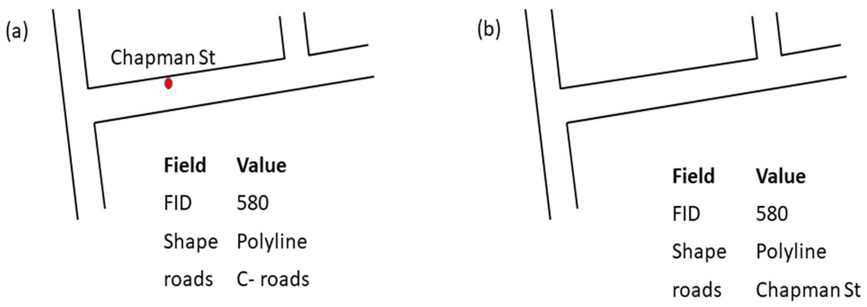
3.2.2. Conversion of Annotations
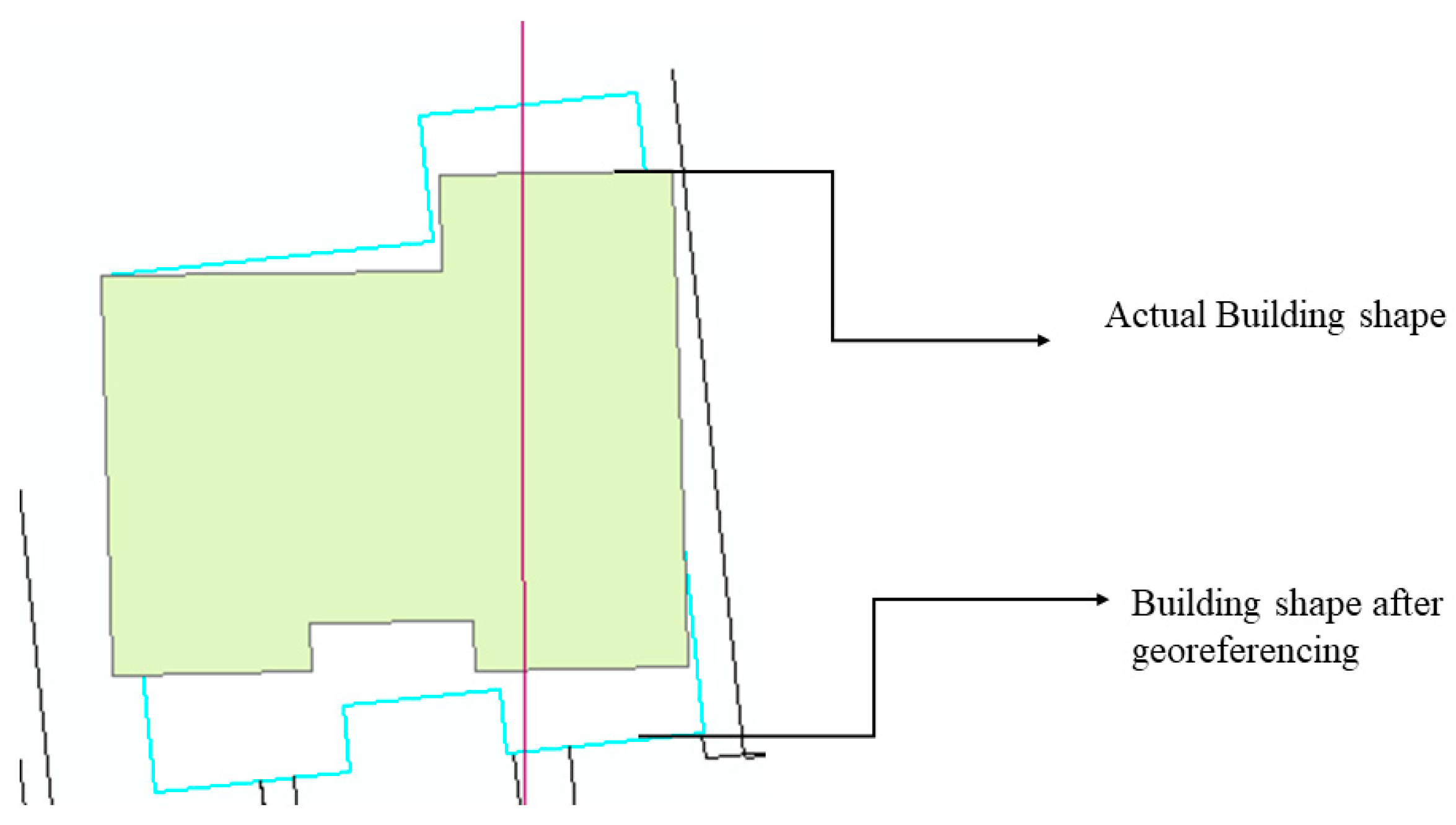
3.2.3. Inaccurate Geometry
3.2.4. Redundant Polygons
3.3. Input Parameters
4. Case Study
4.1. Step 1: Information of Interest
4.2. Step 2: Essential Features
4.3. Step 3: GIS Conversion
4.4. Step 4: Georeferencing
4.5. Step 5: GIS Data Cleaning
5. Conclusions
Author Contributions
Funding
Institutional Review Board Statement
Informed Consent Statement
Data Availability Statement
Acknowledgments
Conflicts of Interest
References
- Zhu, J.; Wu, P. Towards Effective BIM/GIS Data Integration for Smart City by Integrating Computer Graphics Technique. Remote Sens. 2021, 13, 1889. [Google Scholar] [CrossRef]
- Baran, M.; Kłos, M.; Chodorek, M.; Marchlewska-Patyk, K. The Resilient Smart City Model–Proposal for Polish Cities. Energies 2022, 15, 1818. [Google Scholar] [CrossRef]
- Cheng, J.C.P.; Deng, Y. An Integrated BIM-GIS Framework for Utility Information Management and Analyses. In Proceedings of the 595 International Workshop on Computing in Civil Engineering, Austin, TX, USA, 21–23 June 2015; pp. 667–674. Available online: https://ascelibrary.org/doi/abs/10.1061/9780784479247.083 (accessed on 27 July 2021).
- Scholtenhuis, L.L.; Zlatanova, S.; den Duijn, X. 3D Approach for Representing Uncertainties of Underground Utility Data. In Proceedings of the International Workshop on Computing in Civil Engineering, Seattle, WA, USA, 25–27 June 2017; pp. 369–376. [Google Scholar]
- Crawford, D.; Hung, M.-C. Implementing a Utility Geographic Information System for Water, Sewer, and Electric: Case Study of City of Calhoun, Georgia. URISA J. 2015, 26, 25–34. [Google Scholar]
- Derrible, S. Urban Engineering for Sustainability; MIT Press: Cambridge, MA, USA, 2019; 656p. [Google Scholar]
- Metje, N.; Hojjati, A.; Beck, A.; Rogers, C.D.F. Improved underground utilities asset management—Assessing the impact of the UK utility survey standard (PAS128). Proc. Inst. Civ. Eng.-Munic. Eng. 2020, 173, 218–236. [Google Scholar] [CrossRef] [Green Version]
- Fenais, A.; Ariaratnam, S.T.; Ayer, S.K.; Smilovsky, N. Integrating Geographic Information Systems and Augmented Reality for Mapping Underground Utilities. Infrastructures 2019, 4, 60. [Google Scholar] [CrossRef] [Green Version]
- Esekhaigbe, E.; Kazan, E.; Usmen, M. Integration of Digital Technologies into Underground Utility Asset Management. Open J. Civ. Eng. 2020, 10, 403–428. [Google Scholar] [CrossRef]
- Lv, Z.; Li, X.; Wang, W.; Zhang, B.; Hu, J.; Feng, S. Government affairs service platform for smart city. Futur. Gener. Comput. Syst. 2018, 81, 443–451. [Google Scholar] [CrossRef]
- Venigalla, M.; Casey, M. Innovations in Geographic Information Systems Applications for Civil Engineering. J. Comput. Civ. Eng. 2006, 20, 375–376. [Google Scholar] [CrossRef]
- Akin, O. CAD/GIS Integration: Rationale and Challenges. In CAD and GIS Integration; Karimi, H.A., Akinci, B., Eds.; CRC Press: Boca Raton, FL, USA, 2010; pp. 51–71. ISBN 978-1-4200-6805-4. [Google Scholar]
- Zhu, J.; Wang, X.; Chen, M.; Wu, P.; Kim, M.J. Integration of BIM and GIS: IFC geometry transformation to shapefile using enhanced open-source approach. Autom. Constr. 2019, 106, 102859. [Google Scholar] [CrossRef]
- Balasubramani, B.S.; Badhrudeen, M.; Derrible, S.; Cruz, I. Smart Data Management of Urban Infrastructure Using Geographic Information Systems. J. Infrastruct. Syst. 2020, 26, 06020002. [Google Scholar] [CrossRef]
- Bansal, V.K. Integrated CAD and GIS–Based Framework to Support Construction Planning: Case Study. J. Arch. Eng. 2017, 23, 05017005. [Google Scholar] [CrossRef]
- Shao, W.; Zhang, H.; Liu, J.; Yang, G.; Chen, X.; Yang, Z.; Huang, H. Data Integration and its Application in the Sponge City Construction of CHINA. Procedia Eng. 2016, 154, 779–786. [Google Scholar] [CrossRef] [Green Version]
- He, L.; Wu, G.; Dai, D.; Chen, L.; Chen, G. Data Conversion between CAD and GIS in Land Planning. In Proceedings of the 2011 19th International Conference on Geoinformatics, Shangai, China, 24–26 June 2011; pp. 1–4. [Google Scholar]
- Xie, Q.; Wei, B.; Zhang, K.; Wang, Z. Format Conversion between CAD Data and GIS Data Based on ArcGIS. In International Conference on Intelligent Earth Observing and Applications 2015; International Society for Optics and Photonics: Guilin, China, 2015; Available online: https://www.spiedigitallibrary.org/conference-proceedings-of-spie/9808/980818/Format-conversion-between-CAD-data-and-GIS-data-based-on/10.1117/12.2207479.short (accessed on 4 May 2021).
- Gao, F.; Tang, X. Research on Computer Aided Design and GIS Conversion Method. J. Multimed. Process. Technol. 2017, 8, 5. [Google Scholar]
- Wang, H.W.; Kui, H.L.; Li, S.W.; Li, G. Research on CAD Data Format Conversion for Transport Infrastructure Information. Adv. Mater. Res. 2011, 305, 239–242. [Google Scholar] [CrossRef]
- Karan, E.P.; Irizarry, J.; Haymaker, J. BIM and GIS Integration and Interoperability Based on Semantic Web Technology. J. Comput. Civ. Eng. 2016, 30, 04015043. [Google Scholar] [CrossRef]
- Diakite, A.A.; Zlatanova, S. Automatic geo-referencing of BIM in GIS environments using building footprints. Comput. Environ. Urban Syst. 2019, 80, 101453. [Google Scholar] [CrossRef]
- Guthrie CAD/GIS. Guthrie CAD/GIS Software|Markup CAD, GIS to CAD/ KML, CAD to GIS, First Article Inspection, QA, QS, Overlay Drawings, Batch Print. 2022. Available online: https://www.guthcad.com/ (accessed on 21 November 2021).
- Zhen, L.; Jing, C.; Chen, X. Files’ Conversion from CAD to GIS Using Spatial Data Conversion Tools Provided by FME. In Proceedings of the 2012 International Conference on Computer Science and Service System, Nanjing, China, 11–13 August 2012; pp. 1939–1942. [Google Scholar]
- Karduni, A.; Kermanshah, A.; Derrible, S. A protocol to convert spatial polyline data to network formats and applications to world urban road networks. Sci. Data 2016, 3, 160046. [Google Scholar] [CrossRef]
- Noardo, F.; Harrie, L.; Ohori, K.A.; Biljecki, F.; Ellul, C.; Krijnen, T.; Eriksson, H.; Guler, D.; Hintz, D.; Jadidi, M.A.; et al. Tools for BIM-GIS Integration (IFC Georeferencing and Conversions): Results from the GeoBIM Benchmark 2019. ISPRS Int. J. Geo-Inf. 2020, 9, 502. [Google Scholar] [CrossRef]
- Xu, X.; Cai, H. Semantic approach to compliance checking of underground utilities. Autom. Constr. 2019, 109, 103006. [Google Scholar] [CrossRef]
- Halfawy, M.R. Municipal information models and federated software architecture for implementing integrated infrastructure management environments. Autom. Constr. 2010, 19, 433–446. [Google Scholar] [CrossRef]
- Demir Altıntaş, Y.; Ilal, M.E. Loose coupling of GIS and BIM data models for automated compliance checking against zoning codes. Autom. Constr. 2021, 128, 103743. [Google Scholar] [CrossRef]
- Dao, J.; Ng, S.T.; Yang, Y.; Zhou, S.; Xu, F.J.; Skitmore, M. Semantic framework for interdependent infrastructure resilience decision support. Autom. Constr. 2021, 130, 103852. [Google Scholar] [CrossRef]
- Badhrudeen, M.; Naranjo, N.; Movahedi, A.; Derrible, S. Machine learning based tool for identifying errors in CAD to GIS converted data. In Innovation for Sustainable Infrastructure; Ha-Minh, C., Dao, D.V., Benboudjema, F., Derrible, S., Huynh, D.V.K., Tang, A.M., Eds.; CIGOS 2019; Lecture Notes in Civil Engineering; Springer: Singapore, 2020; pp. 1185–1190. [Google Scholar]
- Yang, Y.; Ng, S.T.; Dao, J.; Zhou, S.; Xu, F.J.; Xu, X.; Zhou, Z. BIM-GIS-DCEs enabled vulnerability assessment of interdependent infrastructures—A case of stormwater drainage-building-road transport Nexus in urban flooding. Autom. Constr. 2021, 125, 103626. [Google Scholar] [CrossRef]


| Challenges with Data | Challenges with Conversion |
|---|---|
| Incomplete data | Attribute structuring |
| Inaccurate data | Topology |
| Data collected does not match need | Inconsistent naming practices |
| Platform | Problem Description | Example |
|---|---|---|
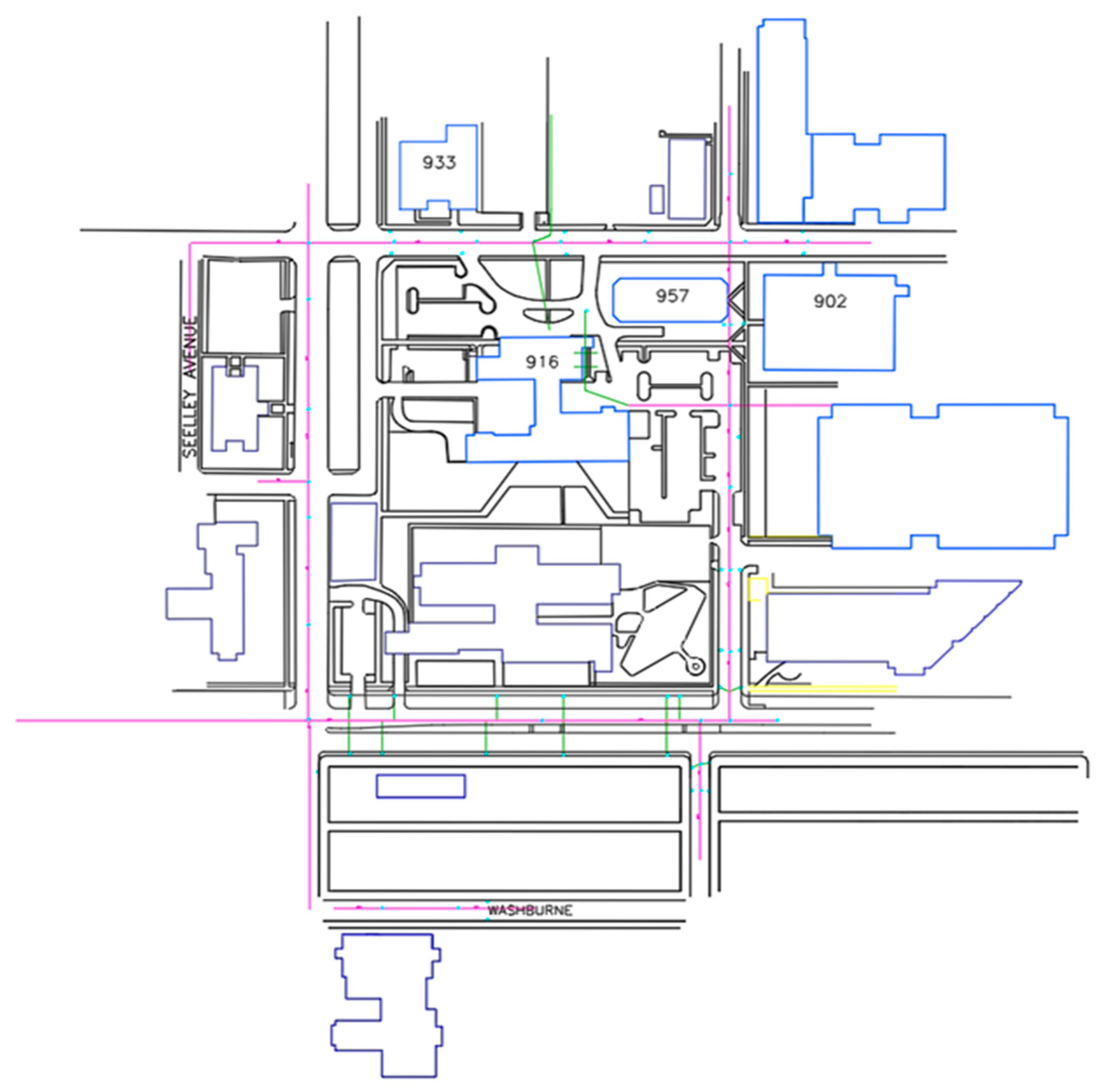
| CAD | Insufficient (or no) metadata | No information about the infrastructure network that has abandoned pipes. |
| Misplacement of text | Pipe diameter details placed inaccurately near another pipe. | |
| Inaccurate geometry | Wrong building shape (see below: Section c) | |
| Text separating lines, thus creating gaps | (see below: Section a) | |
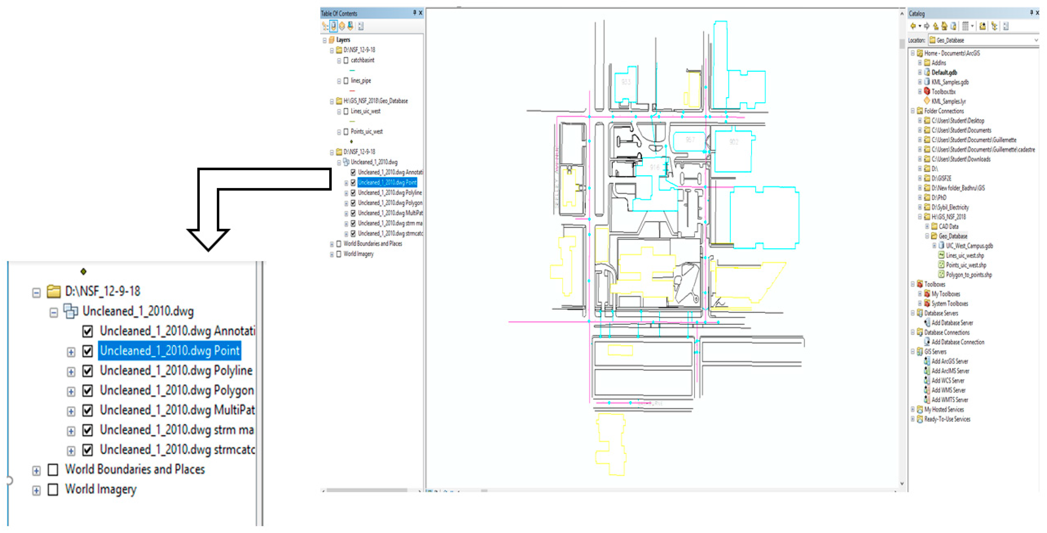
| GIS | Polygons made by continuous lines but not closed | Buildings without a closed form. |
| Annotations | (see below, Section c) | |
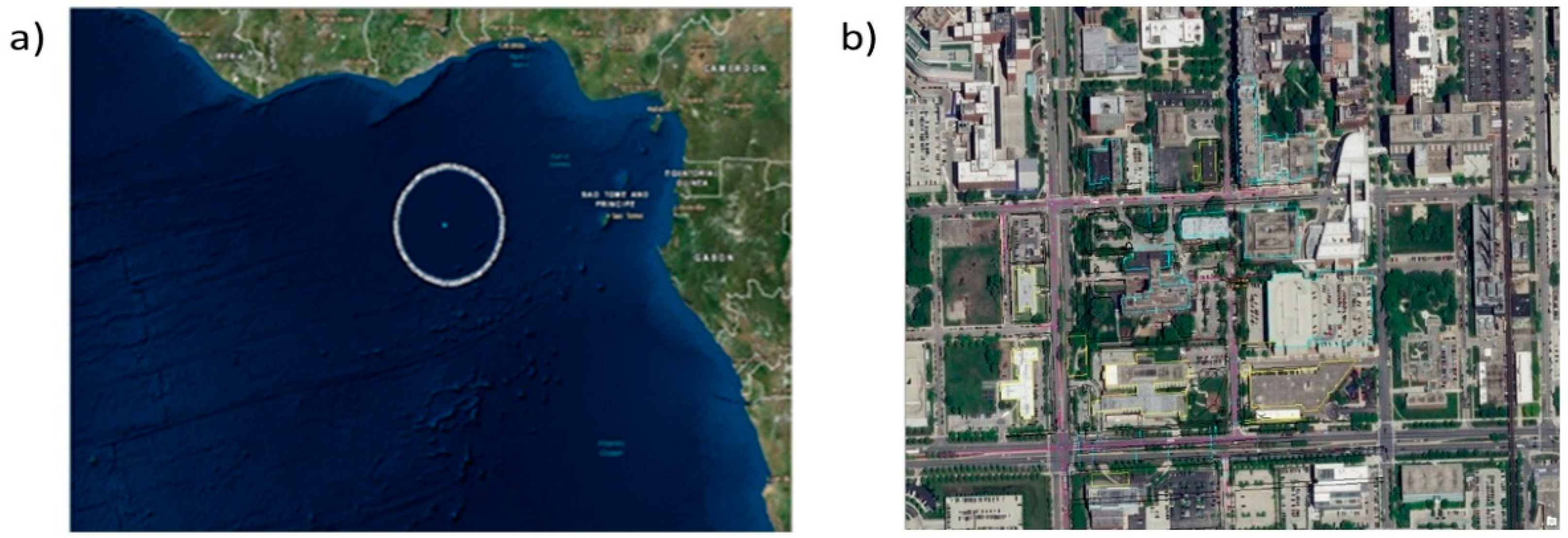
| No georeferencing | (see below: Section 4. d) | |
| Redundant polygons | (see below: Section d) |
Publisher’s Note: MDPI stays neutral with regard to jurisdictional claims in published maps and institutional affiliations. |
© 2022 by the authors. Licensee MDPI, Basel, Switzerland. This article is an open access article distributed under the terms and conditions of the Creative Commons Attribution (CC BY) license (https://creativecommons.org/licenses/by/4.0/).
Share and Cite
Badhrudeen, M.; Boria, E.S.; Fonteix, G.; Siciliano, M.D.; Derrible, S. The C2G Framework to Convert Infrastructure Data from Computer-Aided Design (CAD) to Geographic Information Systems (GIS). Informatics 2022, 9, 42. https://doi.org/10.3390/informatics9020042
Badhrudeen M, Boria ES, Fonteix G, Siciliano MD, Derrible S. The C2G Framework to Convert Infrastructure Data from Computer-Aided Design (CAD) to Geographic Information Systems (GIS). Informatics. 2022; 9(2):42. https://doi.org/10.3390/informatics9020042
Chicago/Turabian StyleBadhrudeen, Mohamed, Eric Sergio Boria, Guillemette Fonteix, Michael D. Siciliano, and Sybil Derrible. 2022. "The C2G Framework to Convert Infrastructure Data from Computer-Aided Design (CAD) to Geographic Information Systems (GIS)" Informatics 9, no. 2: 42. https://doi.org/10.3390/informatics9020042
APA StyleBadhrudeen, M., Boria, E. S., Fonteix, G., Siciliano, M. D., & Derrible, S. (2022). The C2G Framework to Convert Infrastructure Data from Computer-Aided Design (CAD) to Geographic Information Systems (GIS). Informatics, 9(2), 42. https://doi.org/10.3390/informatics9020042


