Article

Designing Virtual Pathways for Exploring Glacial Landscapes of Glacier National Park, Montana, USA for Physical Geography Education

1
Environmental Studies M.S. and Sustainability Education Ph.D. Programs, Prescott College, Prescott, AZ 8630, USA
2
Department of Earth and Environmental Sciences, Mount Royal University, Calgary, AB T3E6K6, Canada
3
College of General Studies, University of Phoenix, Phoenix, AZ 85040, USA
4
Department of Geography, University of Hildesheim, 31141 Hildesheim, Germany
5
Department of Geography, Virginia Tech, Blacksburg, VA 24061, USA
6
Department of Cultural Sciences, Mesa Community College, Mesa, AZ 85202, USA
7
AI/ML Solutions, Tecnotree, 02150 Espoo, Finland
8
Department of Geography, Texas State University, San Marcos, TX 78666, USA
*
Author to whom correspondence should be addressed.
Educ. Sci. 2024, 14(3), 272; https://doi.org/10.3390/educsci14030272
Submission received: 19 October 2023 / Revised: 2 February 2024 / Accepted: 26 February 2024 / Published: 5 March 2024
(This article belongs to the Special Issue Progress in Geography Education Research)

Abstract

:
Virtual field trips in physical geography transcend our human limitations regarding distance and accessibility, allowing students to experience exemplars of physical environments. These experiences can be critical for students to connect to the physical world beyond traditional classroom formats of communicating themes and features in physical geography. To maximize the learning potential of these experiences, designers must engage in a translational process to take resources and content from the physical world and migrate it to an online, virtual format. However, these virtual learning experiences need to account for how learners learn; and should draw heavily on the foundations of educational research and field sciences, while highlighting the awe and beauty of the natural landscape itself. Crafting these spatial stories of the natural world with learning elements requires careful and intentional design to maximize the perception of physical features, patterns, and processes at the landscape scale. To help field-trip developers comprehend the workflows used to create perceptible, rich environments that spur students’ learning, we propose a development process (TECCUPD) as a guide to navigate the intersection of education and science, using an example of geodiversity and alpine glacial landscapes found in Glacier National Park, Montana.

1. Introduction

1.1. Virtual Learning Experiences and Their Application to Physical Geography

Contemporary digital field geographies are positioned at the interface between physical and virtual worlds using emerging technologies, field methods, and techniques to situate digital phenomena with geographic inquiry for building geographic and scientific knowledge and skills [1,2,3,4]. Field-based and place-based virtual learning experiences (VLEs), also referred to as virtual field trips (VFTs) (both referred to as VLE throughout the paper), engage students within the context of the physical environment and extend the ability of learners to build physical geography knowledge by exploring digital proxies of landscapes. VLEs expand the reach of physical geography education and research by increasing access to examples of physical fieldwork and field site locations [5,6]. Virtual proxies of field sites house readily accessible examples of iconic phenomena, such as glaciers (Glacier National Park), volcanic calderas (Yellowstone National Park), and canyons (Grand Canyon National Park), and the processes that form them, situated within the context of their natural environment. Immersive, authentic experiences (visual realism, environmental realism, sensation, and emotional engagement) enable educators and learners to explore expansive views of awe-inspiring landscapes that can create affective and cognitive benefits, such as enhanced attention and memory, improved mood, creativity, and environmental connection [7,8].
Virtual reality (VR) is an educational alternative to in situ field trips that address limitations of funding, transportation, equitable access, and safety. We argue that virtual experiences are necessary to bring rich, iconic, real-world examples of physical geography into classrooms.

1.2. Objective of This Work

We share the design and development of a VLE for an Introduction to Physical Geography course. The illustrative example focuses on alpine glacial landscapes in Glacier National Park, Montana, USA. A development process is required to support VLE architects in incorporating relevant ideas from education theory into the VLE. The authors propose a stepwise process to support this theory-to-practice translation: Theory, Exploration, Capture, Curate, User, Publish, and Disseminate (TECCUPD) (Figure 1). Our approach is adaptable across multiple levels of teaching and instruction.

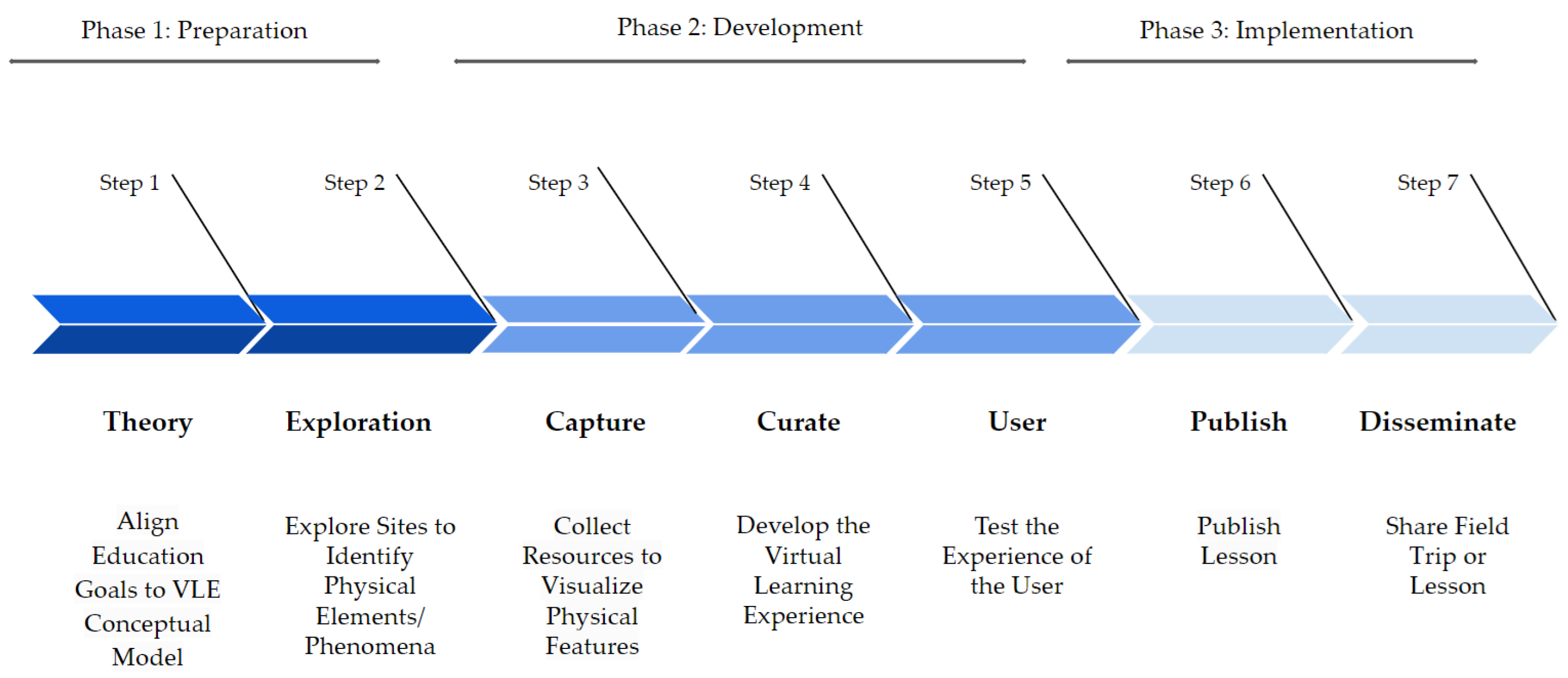
1.3. Towards a VLE Stepwise Development Process: TECCUPD

TECCUPD has three phases that encompass seven steps to guide VLE development (Figure 1). Phase 1: Preparation (Steps 1 and 2) aligns the educational goal to the conceptual model. Phase 2: Development (Steps 3–5) describes the resource collection and its translation into the VLE. Phase 3: Implementation (Steps 6 and 7) addresses the technical components and supporting platforms for VLE publishing and distribution. Phase 1 of TECCUPD is Preparation. Within Phase 1 are Steps 1 (Theory) and 2 (Exploration). Step 1: Theory includes selecting a conceptual framework to define learning and assessment. Doing this allows for the development of the lesson’s educational goals and outcomes, aligned with appropriate theories from the conceptual framework. This initial step is critical to support successful student learning by ensuring experiential activities and thoughtful instructional design. Step 2: Exploration involves examining the physical setting represented by the immersive virtual experience. This process ensures that the virtual proxy collected by the subject matter experts includes all relevant physical geography elements and phenomena that need to be represented in the lesson.
Phase 2 of TECCUPD is Development. Within Phase 2 are Steps 3 (Capture), 4 (Curate) and 5 (User). Step 3: Capture requires the developer to collect photography-based assets (spherical, landscape, macro, and micro), LiDAR capture of features, and/or photogrammetry. In addition, field notes are taken to maximize the value of the observations (location, weather, habitat, plant communities, geology, disturbance, notable patterns, and associated processes that are critical in developing context for instructional choices made with photography, LiDAR, and photogrammetric models. A tool like the geoheritage lesson template designed by Robeck et al. [10], provides an exemplar for organizing site-specific information on physical geography, human communities, and site history. Step 4: Curate involves the further development of supporting resources (GIS layers, maps, and tables). Step 5: User requires user interface testing to ensure that the intended user experience within the VLE was achieved. After the resources, field notes, and research are gathered, the lesson has been built, and the components are integrated into the VLE, the VLE architects should then test all navigation buttons, links, and information points to ensure that there are no broken components that might disrupt the user experience. It is important to verify that the content for pattern and process is situated near the feature representative or digital twin of the phenomena. Checking the quality of the experience across multiple devices, like VR headsets, tablets, desktops, and smartphones, as well as across browsers, is a best practice.
Phase 3 of TECCUPD is Implementation. Within Phase 3 are Steps 6 (Publish) and 7 (Disseminate). Step 6: Publish requires developers to develop a lesson plan, which allows for sharing of refined textual information about the context, learning outcomes, instructional strategies, and additional information useful for implementation of the lesson in a learning environment. Once the completed trip is developed and refined, digital platform users can publish their VLE. Step 7: Disseminate allows the VLE creator to share the VLE on many different educational resource web pages for formal and informal education for broad dissemination and reach to education communities. The ultimate goal of this step is to make the VLEs accessible and shared broadly to benefit the greater education community.
TECCUPD, at the most basic level, allows us to take the conceptual framework and create and share VLEs. The illustrative example to follow describes TECCUPD implementation for the creation of a glacial landscape geodiversity VLE.

2. An Illustrative Example of VLE Development: Development of a Glacial Landscape Geodiversity Experience

Here, we describe the development of a VLE focused on an alpine glacial landscape and geodiversity using the TECCUPD process. Geodiversity describes the pattern, variation, and range of geological, geomorphological, and hydrological elements that underpin the earth’s landforms and biodiversity in a certain area and can be used widely in education [11,12]. Although the usages and definitions vary across the published literature, according to Brilha [13], geodiversity encompasses scientific and educational values, “directly related to their importance in supporting present and future knowledge of how the geosphere works and interacts with other earth systems, namely the biosphere, the hydrosphere, and the atmosphere”. The focus of the VLE is on the educational value of geodiversity. The resulting lesson is entitled Field Trip: Geodiversity of Grinnell, Sexton, and Sperry Glacier Basins [14,15]. Using key topics from introductory physical geography, the following high-level learning objectives were identified for the VLE:
  • To identify examples of landscape change in glacial landscapes;
  • To explore geodiversity of a topographically complex glacier landscape.
Glacier National Park (GNP) is situated in northwest Montana, within the Northern Rocky Mountain physiographic province of the USA. Its remote location and rugged, mountainous landscape create a unique and complex set of terrain attributes characterized by high geodiversity and geoheritage. The original caretakers of the eastern side of this land before the establishment of GNP in 1910 are the Pikuni or South Piegan Indians of the Blackfeet Nation and Reservation [16]. The area is thus rich in geosite elements (i.e., features that connect people, places, and physiography), and its landscapes are exemplars of alpine physical geography features and processes.
Resource collection took place from July 2021 through August 2021 and July 2022 through August 2022. Grinnell Glacier, Sexton Glacier, and Sperry Glacier were the targeted sites for collection. Site visitation focused on three alpine glacier basins. Based on aerial imagery from 2015, there were 26 named glaciers that met the size criteria of 0.1 km2, nine fewer than in 1966. Of the 26 remaining in 2015, some may already be too small to be considered glaciers. In addition to the roughly two dozen named glaciers that the U.S. Geological Survey monitors, the park also hosts several unnamed glaciers, about a dozen rock glaciers, and many snow fields (Table 1 and Figure 2) [17].
To communicate representation of the physical geography and geoheritage concepts, the researchers chose study sites situated on the eastern side of the Continental Divide near the centrally located St. Mary’s and Many Glacier entrances. The three glaciers targeted for site assessment and data collection were the following: Grinnell Glacier (48.75° N, 113.72° W), Sexton Glacier (48.70° N, 113.63° W), and Sperry Glacier (48.62° N, 113.76° W). The glaciers of Glacier National Park have substantially decreased in aerial extent over the last several decades due to regional climate change (Table 1) [18].
The remote location of most glaciers within Glacier National Park makes organized student field excursions largely prohibitive. Trail access to most glacier forefields within GNP requires lengthy and strenuous hiking with fall and animal hazards (Table 1). These cirque glaciers are positioned on steep vertical-cliff-edged terrain near mountain tops with steep slopes of talus and snowfields and are risky to traverse.

2.1. Phase 1. Preparation (Step 1: Theory and Step 2: Explore)

Preparation starts with considering the normative disciplinary content and curriculum fit to begin drafting learning objectives. In this example, learning objectives were drafted prior to considering the site of study. After a draft of learning objectives was identified, a location was identified. With drafted learning objectives and an identified site, the TECCUPD development process can begin. First, theory is considered to help make instructional and design choices. Second, a thorough site exploration is conducted to refine learning objectives and gain access to available information associated with the site.

2.1.1. Step 1: Theory—Align Education Goals to VLE Theoretical Framework

We used a learning construct to identify and develop the core learning objectives for VLE development. Our guiding learning theories are social constructivism [19,20], conceptual change [21,22,23,24], systemic functional linguistics [25,26,27,28,29], and the skill of spatial thinking [30,31,32]. We used social constructivism to emphasize human and environment interactions as related to situated and authentic learning and an active, context-based knowledge construction of glacial landscapes. Our individual perceptions of these landscapes are influenced by historical (e.g., margin dates and glacier extent information), social (environmental ethics and conservation priorities), and cultural (interaction and adaptation to the landscape) factors. Geodiversity and glacier geomorphology offer rich, perceptible examples of how landscapes are dynamic and change over space and time in response to the changing environment. Moreover, these differences between alpine glacial basins offer examples of how spatial variation in landscapes influences mechanisms and processes resulting in different types of patterns. Learning objectives build on this and will be impacted by social interactions. We use conceptual change theory because the learners’ prior knowledge will impact their learning. To identify and address any student misconceptions by addressing students’ preconceptions of physical geography patterns and processes, we chose to design the VLE using interactive examples of physical phenomena to challenge and refine their understanding [21]. We chose systemic functional linguistics, the learning construct that highlights language as contextual, to introduce key technical terms associated with glacier geomorphology and their definitions within the VLE, to help students to use and understand scientific concepts related to physical geography. Finally, we chose a spatial thinking approach to explore how glaciers alter the landscape over space and time. This approach assists learners in thinking about direction, scale, pattern, and process as glacier dynamics shift with environmental conditions that transform the physical environment.
After considering our drafted learning objectives, it was apparent that there were additional opportunities for further enhancing our learning objectives. The initial objectives were as follows:
  • To identify examples of landscape change in glacial landscapes;
  • To explore geodiversity of a topographically complex glacier landscape.
Additional opportunities to support social engagement, maximize the ability to consider students’ prior knowledge, differentiate between technical and colloquial language use, and further enhance higher-level spatial thinking skills were needed to improve the original learning objectives. These opportunities were used to guide the site exploration so that learning objectives could be improved prior to the development of the VLE.

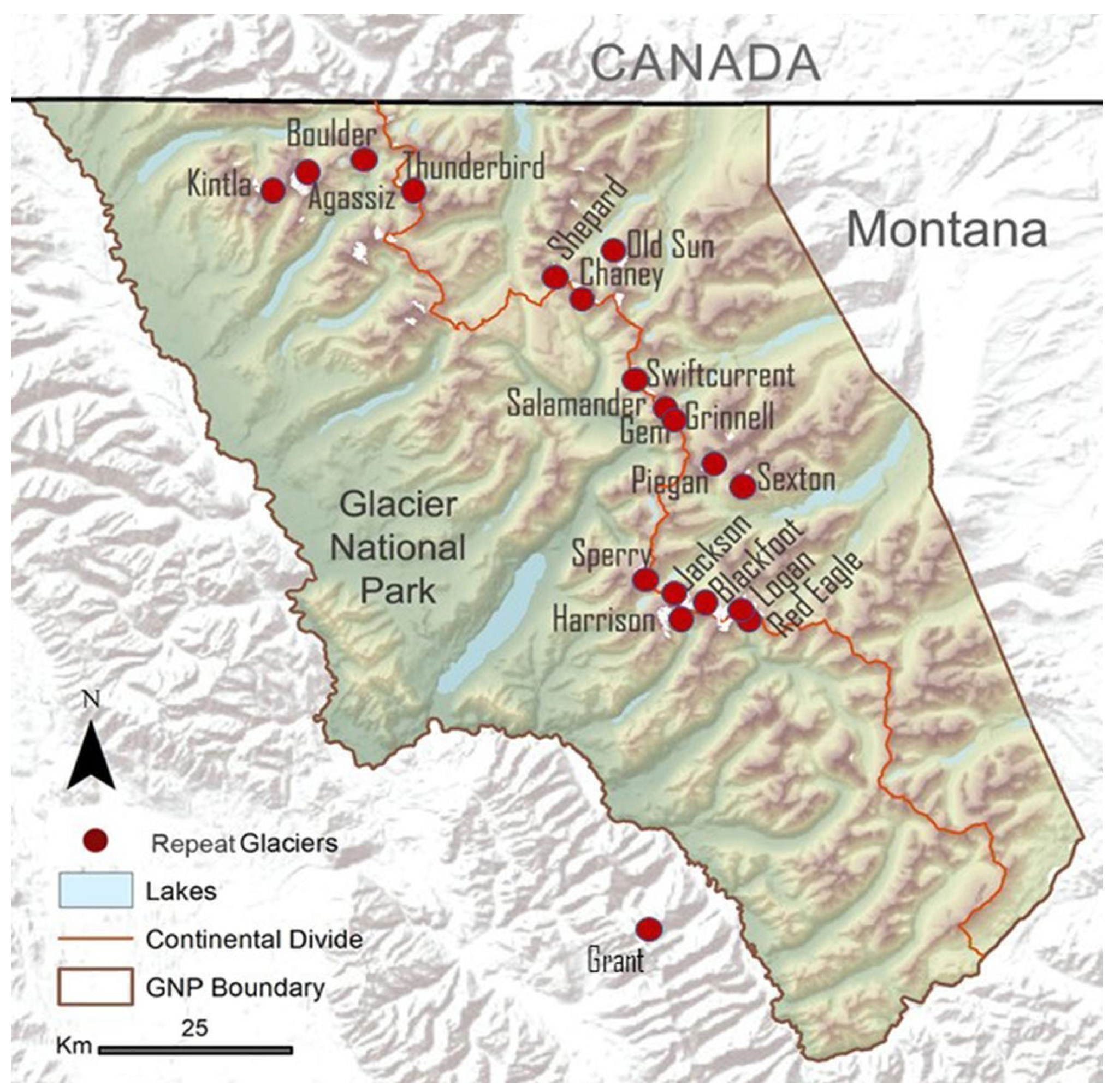
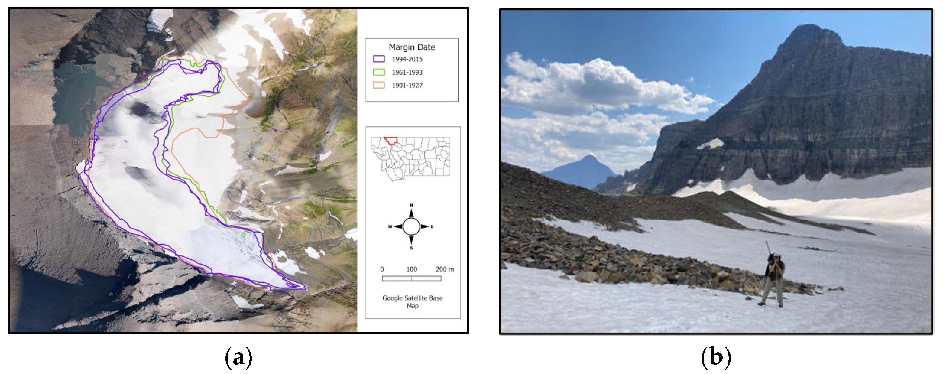
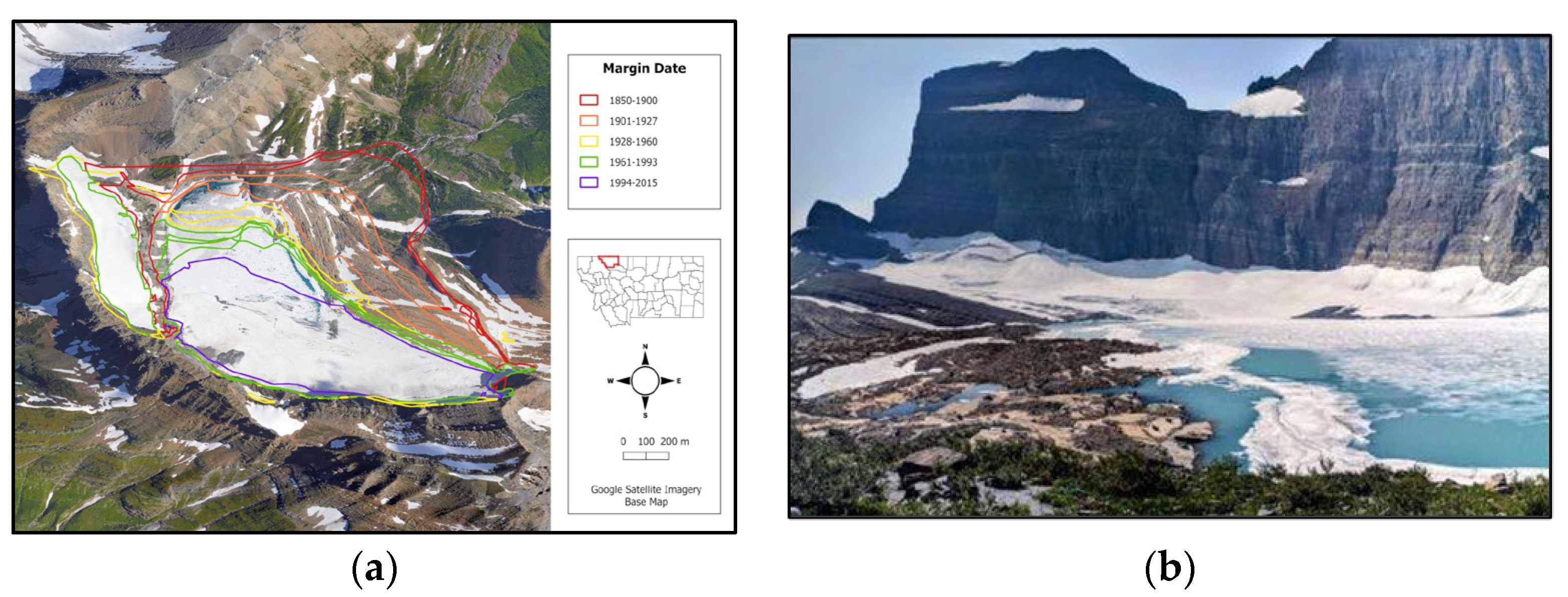
2.1.2. Step 2: Explore—Exploration of Sites to Identify Physical Elements/Phenomena

We assessed each basin for geomorphic variability and geodiversity to examine spatial characteristics and patterns. VLE content was developed using information gathered on these observations from the field notes (Table 2). As glaciers work a landscape, they leave behind distinct markings and patterns. Field notes recorded for the Grinnell, Sexton, and Sperry glacial basins describe features like hanging valleys and waterfalls. Specifically, at Grinnell, there is an example of a Cyclopean stair, a stair-step-like pattern created as the glacier erodes the valley floor. At Sexton, the scooped-out depression of the cirque glacier shows that ice accumulation is present. Directional movement indicators were found, including striations, as well as evidence of the rocks carried by the ice and used to create those striations. Further indicators of directional movement included patterns of crescentic gouges and chattermarks. As glaciers advance and retreat, their erosional forces create and leave behind transport material, known as glacial till. Evidence of till deposition at the lateral edges at Grinnell Glacier show the Little Ice Age lateral moraines. At Sexton Glacier, the till is deposited at the glacier terminus, creating steep, terminal moraines at the cliff-edge. Its presence may become a geomorphic hazard, with rock falls to the valley below. Sperry is the only glacier studied that had both the remaining Little Ice Age and Early Holocene moraines [33]. A glacial landscape characteristic of Grinnell Glacier is an extensive field of roche moutonnées that show evidence of abraded backslopes and plucking from the steeper front, which is created as the glacier moves, ripping away the bedrock material still frozen to it. The backslope is marked by striations and crescentic chattermarks. As ice melts into ice-scour depressions, glacial lakes form. Grinnell Glacier has both Upper Grinnell Lake and Lower Grinnell Lake. A meltwater stream at Upper Grinnell Lake may eventually weaken the ice-scoured rock and breach, in which case, there is the additional geomorphic hazard potential of a glacier outburst flood.
Detailed field notes maximize the value of observations for later VLE development. The goals of the learning objectives define the theme of resource collection. Fieldwork information requires collection of the date, time, and location. Notations with the geographic coordinates of the large-scale area and the site-specific data-collection location situate the field trip. Using topographic features for points of reference with cardinal directions is ideal. Transcribing details of the natural area (known geology, plant communities, plant establishment patterns, water sources on the landscape, gradients, and evidence of human interactions with the natural site), weather conditions (estimated temperature, sky conditions, wind, precipitation, snow, recent storm events or lack thereof, etc.) in which digital data are collected helps to frame site characteristics and attributes, as well as explain any distortions that may appear in the digital resources. Attention to the site’s natural history is important, and habitat descriptions must include any factors that might influence biotic communities and abiotic features (plant distribution and growth forms, signs of animals, light, drainages, soil moisture, sites exposed to the elements, disturbance types, and potentially, the disturbance frequency). Researching the site’s historical context and current site management may prove helpful in exploring site patterns and processes. It is important to note any questions the field collector may have about the landscape and to consult with additional subject-matter experts at a future date if these individuals are absent for in situ resource collection.
Once in the field, we were able to determine more specific outcomes/objectives to craft the VR spatial story of Grinnell, Sexton, and Sperry Glacier to guide learning in the virtual reality environment. The initial, identified short-list objectives were developed into a richer set of learning outcomes/objectives related to specific earth science examples tied to the physical geography for targeted resource capture. The key learning objectives for this lesson were as follows:
  • Identify key drivers of change in the terrestrial-atmospheric system, such as climate, landforms, and ecosystems;
  • Identify specific examples of how the terrestrial–atmospheric system has changed in Glacier National Park;
  • Explain the concept of geodiversity and its importance in understanding natural environments;
  • Assess the geodiversity and geomorphological diversity in Glacier National Park;
  • Compare and contrast the geodiversity and geomorphological diversity of the study sites in Glacier National Park;
  • Analyze, discuss, and reflect on collected data and findings to draw conclusions about ongoing environmental changes.
Virtual field trip creation requires field-based asset collection that can be used to build-out the “spatial story” of the geoscience topic within virtual landscapes. A list of natural phenomena is needed to collect resources for field notes, imagery, 3-D models, and measurement capture. Once phenomena are identified, then background research is performed on the site history, geoheritage, trail access and difficulty to begin digital resource collection.

2.2. Phase 2. Development (Step 3: Capture, Step 4: Curate, and Step 5: User)

Phase 2 involves capturing location-based and digital-mediated spatial representations of the environment guided by the information revealed in Step 2: Explore. Geography-rich media (geomedia) include photo spheres, LiDAR models, and imagery at the micro, macro, and landscape scales. The geomedia allow students to engage with two- and three-dimensional objects to learn geographic concepts, such as spatial visualization, spatial orientation, and how these objects change in representation with shifting perspectives (i.e., rotation of the environment as students walk around a roche moutonnée as found on the glacier). Additionally, these resources support student exploration and comprehension of spatial relationships, such as the patterns and processes found in geomorphology and geology disciplines (depositional and erosional information housed within the landscape and in the LiDAR models) used to translate these spatial relationships while emphasizing pillars of geographic associations of distance, space, and time [34].
Combined with the reconnaissance information from the field notes, the photo sphere becomes an information portal and a tool for reflection. This method is an additional cross-check, and validation of these resources, which are curated from the resource collection within the GeoEPIC platform and transitioned from the in-person field experience to the virtual experience [35,36].
Three-dimensional Lidar models, such as the Grinnell Glacier roche moutonnée feature showing striations, chattermarks, polishing and plucking, allow for students to engage with the disembedded feature and manipulate the digital twin to explore all aspects of the feature. Auditory components work in combination with the visual and manipulative models to heighten perception and deepen the sense of place. An additional benefit of photography is that the information can later be reviewed again by a group of subject-matter experts to interpret the landscape to select the most helpful information to build out the content.

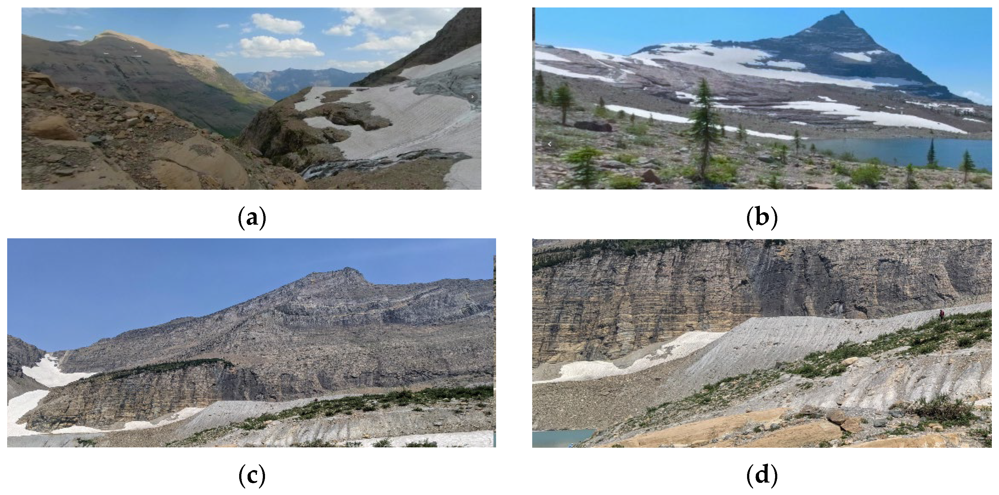
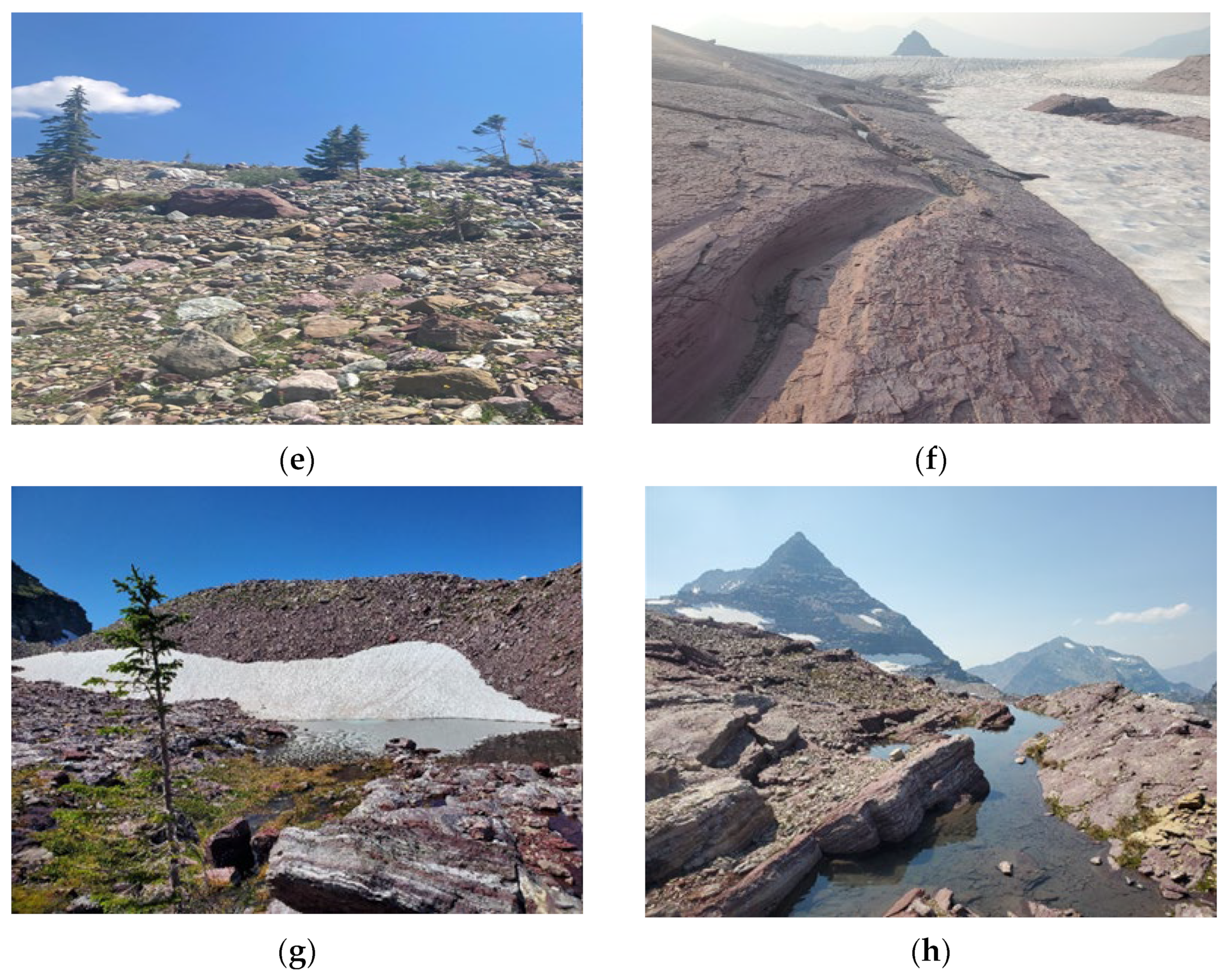
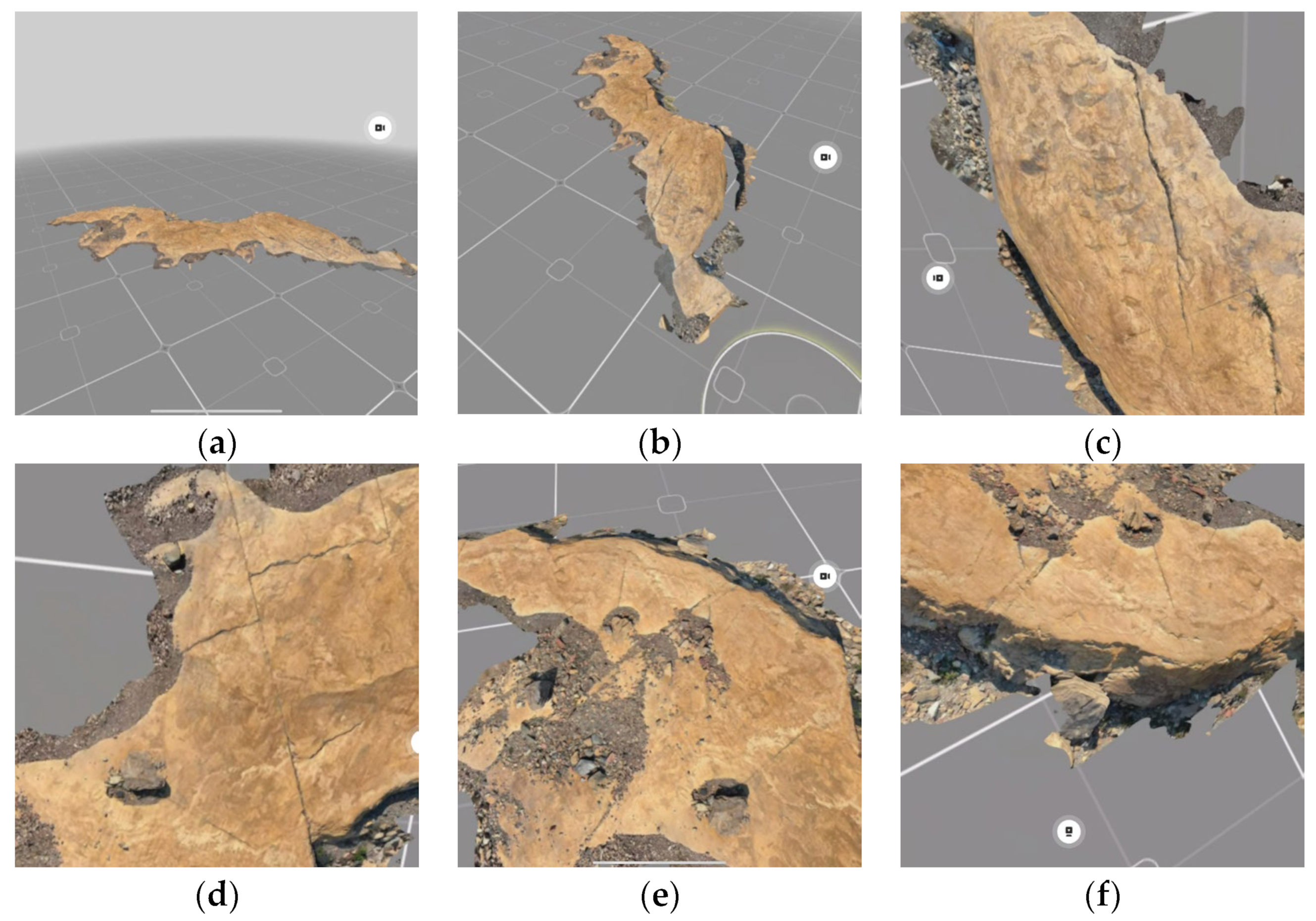
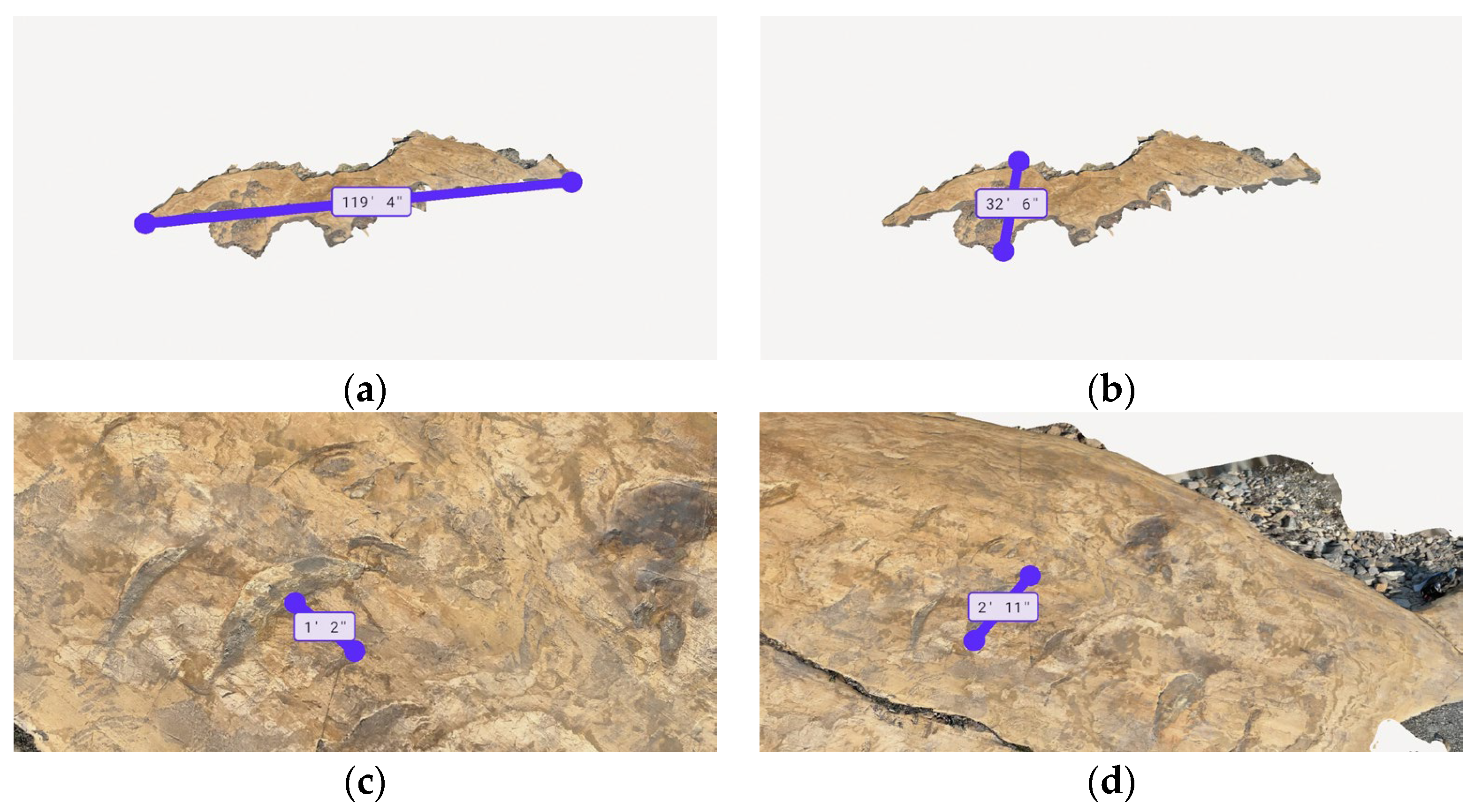
2.2.1. Step 3: Capture—Collect Resources to Visualize Physical Features

We were guided by the geographic inquiry process (ask, collect, visualize, create, and act) [37,38] in combination with the Brilha geodiversity index. The index is a helpful tool to score and rank the geodiversity at each site to assist their comparison through discussion. Because the glacial basins are in close proximity and have similar geology, we adapted the index for use with geomorphodiversity to explore the unique patterns associated with the size and shape of each glacial basin [13]. The geodiversity index was modified specifically with a physical geography classroom in mind when collecting geodiversity content to furnish the virtual landscape with visual and textual information (Table 3).
Resources captured for these sites are varied. Photography that captures spherical landscape, macro, and micro scales are important VLE components. These photography-based assets are used in different ways to create the virtual landscape for these immersive experiences and to create fine details of physical features that fill the scene with examples of associated geomorphodiversity patterns and processes. Wide shots that offer panoramas establish the environment and relationships highlighting space and time. Field collections at the Glacier National Park site are complicated by the terrain. Some studies have employed the use of drones to overcome the obstacles [39]; however, drone use within the National Parks is limited and/or prohibited. Overcoming these logistical challenges is critical to offer an on-site perspectives and allows scientists and educators to locate and capture unique instructional assets.
Associating the 3-D representation of surface geology and geomorphology with the 360° landscapes helps educators and scientists characterize the environment. For visualizations to create the landscape for the virtual experience, 360° photographs, known as photo spheres, were collected for each glacier basin. The photo spheres were taken using an Insta360 ONE R digital camera that captured both the front and back view of the landscape and were calibrated to minimize distortion post-processing (Figure 3). The photo spheres are collected at points above the basin, within the basin, and below the basin for multiple points of view for the virtual experience development team. These multiple points of view were examined to find the points of interest in geomorphology and geology for the field experience discussion.
Additional photographs were taken to provide close-up imagery of physical and biotic features, some of which highlight the geomorphic processes that influence geodiversity. Multiple imagery from landscape, macro, and micro scale-imagery serves as both contextual information to support the lesson and as support for information point hotspots within the virtual landscape (Figure 4a–h).
The following are examples of extracted scenes from spherical photography offering context for the geodiversity lesson (Figure 4): (a) landscape showing Sexton Glacier forefront, which is small in its extent and steeper cirque glacier dimensions [40]; (b) the landscape of Sperry Glacier with a more prominent glacier forefront and a gentler slope and broad extent [41]; (c) landscape showing the Grinnell Glacier and talus slopes to the left and Mt. Grinnell to the right of the scene with the lateral Little Ice Age moraine at the bottom [40]; (d) a macro-view of evidence showing the glacial depositional process through the till deposition with the lateral Little Ice Age moraine, with a person visible on the vegetated slope for scale [40]; (e) moraine stabilization is evident with the established vegetation on the higher slope [40]; (f) evidence of glacial erosion process through deep grooves and shallow scratches across the bedrock surface [41]; (g) examples of the terminal glacial moraine [41]; and (h) roche moutonnée (right, d) on the glacier foreland of Sperry Glacier [41].
LiDAR and photogrammetric scans of these physical features were collected using handheld devices equipped with LiDAR sensors and a camera and are application-capable. The collected point clouds and photographs produces a “mesh”, which is a collection or arrangement of vertices and polygons that create the three-dimensional visualization with precise measurements of the physical features (Figure 5a–f).
The following examples of LiDAR data taken of a sample of the Grinnell Glacier roche moutonnée provide students with an opportunity to engage with the feature through model rotation and exploring different positions relative to the feature for better context of the geomorphology and glacier active process for the geodiversity lesson (Figure 5): (a) a view of the 3-D model of the Grinnell Glacier roche moutonnée stoss (abraded upglacier) face; (b) a lateral view (teleport circle in the foreground) showing both the stoss side and the downglacier, lee-facing (discontinuity in the model is present with visibility of the background between the stoss and lee-facing sides of the model); (c) zone of abrasion featuring joints along the Siyeh limestone bedrock are visible with the glacier polishing the stoss side with sediments and pebble-sized rocks deposited in the depressions in the rock; (d) chattermarks, seen as crescentic gouges in the rock, show the direction of the ice flow; (e) Stoss side view that features both erosional processes (polishing with visible joints and cracks in the bedrock) with the depositional process (debris deposits); and (f) downglacier lee-facing side that shows plucking as quarried pieces of the rock froze to the ice in the low-pressure zone.
The lines and measurements are derived in the Polycam application, which takes the point clouds collected and converts these features into a mesh that is draped with the imagery collected with the camera application of the smartphone or tablet. The following measurements associated with size of the Grinnell Glacier roche moutonnée feature are shown (Figure 6a–d): (a) measurement of the Grinnell Glacier Roche moutonnée across the Stoss side-length measuring 119″ and 4″ (36.37 m); (b) width of the feature is 32′ 6″ (9.9 m); (c) distance between two chattermarks measuring 1′ and 2′ (0.36 m); and (d) the width of the upper chattermark chosen for measurement is 2′ and 11″ (0.88 m).

2.2.2. Step 4: Curate—Develop the VLE

The photo sphere is the foundation of the visual setting. The photo sphere is embedded with visual clues (buttons, information points, and hot spots) developed using the information collected in the field. These visual clues are contact points for knowledge building, using the sense of place to build an individual’s emotional bond to the glacial environment and to develop perceptions around climate change and glacier loss within alpine glacial environments. Our understanding of spatial thinking informs the scenes in order to explore how glaciers alter the landscape over space and time. This approach assists learners in thinking about direction, scale, pattern, and process, as the glacier dynamics shift with environmental conditions that transform the physical environment. To ensure the VLE supported students with the development of scale and pattern, multiple visuals of areas within the glacial basin were collected so that students can make sense of the VLE location within the broader context of its native environment.
As shown above, the alpine glacier VLE weaves together a detailed spatial story of the differences between the glacier basins with imagery, video, photo spheres, figures, and LiDAR models to guide learning. We did not design an assessment for this VLE, as the instructional goal was to build an academic self-concept [42,43,44]. This strategy leverages the learner’s perceptions and a sense of belonging that will impact their ability to learn. Exploring the immersive environment creates a safe space for students to engage with complex physical geography concepts. In VR, high mountain environments that might imperil a student become accessible to all students. The instructional interventions can help students feel like valued members of the scientific learning community. The VLE used glossaries and information points attached to features with technical terms, definitions, and supporting imagery to bridge colloquial language and technical language and resolve any misunderstanding of language that may impact the learning process [26]. The VLE lesson should support authentic tasks performed by field scientists and offer information from field notes and subject-matter experts within the context of the physical setting [8]. We use margin date maps of each glacier to show how the glacier has receded since the Little Ice Age. Reflective questions and interactive models, allowing for adjustment, measurement, and manipulation, offer opportunities for integrating and solidifying knowledge. The photo spheres are used as a foundation of the immersive experiences that enhance spatial understanding of moraine placement, roche moutonnée development, and glacier forefield differences based on the glacier basin type (mountain and cirque glaciers). LiDAR models preserve the size and scale and serve as a digital twin to explore the orientation of striations across the rock, scour patterns, plucking and polishing, as is shown in the roche moutonnée example. All these spatial resources combined offer learner opportunities to detect spatial patterns and infer the dynamic forces of natural processes. The VLE offers freedom to explore according to one’s interest, but as it is designed for an introduction to physical geography for a college-level audience to build physical geography expertise, little gamification occurred in this VLE.
Glacier National Park provides an excellent location to observe features associated with glacial advance and retreat (Table 2). Glaciers in the park have experienced accelerated loss since the Little Ice Age (Figure 7a,b, Figure 8a,b and Figure 9a,b) (Table 1).
Instructional design guides classroom activities to assist students in building and applying their knowledge and skills in the VLE. Tasking the student to role-play as a field researcher can help to secure the student’s confidence in their knowledge of the authentic glacial environment. Students will compare and contrast the different glacier basins using a geodiversity index adapted to geomorphology to discover patterns and processes. For this activity, students explore how the different sizes of basins (extensive versus shallow forefronts) lead to different stages in the development of glacial features. For example, Sexton Glacier’s shallow forefront means that there is less space for the glacier to work the bedrock, resulting in less plucking and underdeveloped roche moutonnées; however, the scoured basin provides an opportunity for terminal moraine development. Students will use spatial thinking concepts to develop normative scientific reasoning and knowledge about places and the features they contain. Role-playing as a field scientist in an immersive physical setting provides the freedom to discover and explore.
The glacial geodiversity fieldtrip was not developed specifically for a gamified experience, which means there is “less fun” in the VLE. However, we provide an example of a VLE entitled, “Field Trip: Escape Iceland” [15]. The design and implementation of this specific VLE required that students role-play as a team member on a research expedition to explore how Iceland’s dynamic natural forces produce unique geodiversity in a perceptible, immersive environment. A megaplume event creates an intense period of volcanic activity, and the contextual application required students to solve a series of Wordle puzzles associated with each lesson to reach the escape route before conditions worsened, all while collecting information to write a final report for their team lead. With these types of assessments, their observations from their exploration of the virtual physical setting are developed into a written reflective report to describe the geodiversity and characterize the site differences between the glacial basins. The students can experience the value in looking at the landscape through a “geographer’s lens.” This approach aims to bridge the gap between theoretical understanding and practical application.

2.2.3. Step 5: User—Test Experience of the User

Following the completion of Step 3: Capture and Step 4: Curate, a prototype of the VLE should be completed. Because the design and development of the VLE is a complex process, it is important to engage in user-experience testing to ensure that the VLE was developed with fidelity to theoretical learning constructs (Table 4).
When considering the visual setting, there should not be clutter, and care should be taken in placing the visual clues so that the natural scene is welcoming and promotes access to build student belonging and inclusion. Placing the visual clues too close may complicate the experience for the student, which might add to frustration and a sense of exclusion. Additionally, information density, the number of information points and the amount of material displayed should be limited so as to not overwhelm the viewer in the scene.
When viewed within the virtual reality headset, learners can walk around the digital twin of the physical feature and explore the different ways in which the glaciers alter the features and landscape and explore pattern and process as well as direction and movement (Figure 5a–f). If the device that was used to scan the feature is available, then the display contains precise distances that can be measured within the application (Figure 6a–d). These data can be exported into point-cloud formats that can be imported into geographic information systems (GIS) for further visualization and analysis.
In the model-viewers in which the 3-D object is displayed, the model of the physical feature enables learners to manipulate the model (zoom in/out and rotate) and explore the arrangement of the feature. In the case study of the glaciers in GNP, it is possible for students to examine the striations left by Sperry Glacier, ripple marks of ancient seabed environments found in the red argillite, or the layering, thinly-bedded strata that exhibit deformation (Figure 10a–c).
Following Step 5: User, there may be additional changes or enhancements made to the VLE to accommodate the results of user-experience testing. After the VLE has been finalized through completion of Steps 3–5 in the TECCUPD process, the VLE may be implemented.

2.3. Phase 3. Implementation

Phase 3 involves Step 6: Publish and Step 7: Disseminate. For Implementation, designers must access a VLE development and login hosting platform and become familiar with assisting the tutorials, templates, documentation, and capabilities of the hosting platform. We used the GeoEPIC platform (https://geoepic.app) (accessed on 15 October 2023) to host VLEs. In GeoEPIC, it is necessary to upload geomedia resources and texts to design the experience into our lesson builder. Using the built-in editor, we formatted and embedded resources into the seamless lesson page.
The various field-trip components relative to Glacier National Park, including the educational narrative, imagery, links to 3-D and LiDAR models, and supporting figures and tables, were uploaded into a digital platform’s resource library. At this time, only the developer and the GeoEPIC editors can access and manipulate the data. Final editing and link management is completed to ensure ease for the user of the virtual experience upon publication.

2.3.1. Step 6: Publish—Publish Lesson

When we were content with the final product, we then chose to Publish, which is a click of a button within the hosting platform. The GeoEPIC editors then review and release the lesson to the public. The final review and approval, publication, archiving, quality assurance, and data security are essential to secure the lesson on the site for use in formal and informal education. This procedural framework empowers teachers and content creators to develop, manage, and publish educational VLE content while fostering collaboration among contributors. The content on GeoEPIC is licensed by Creative Commons: Attribution-Noncommercial-ShareAlike 4.0 International. Educators may access and download the information and may take the collected content and lesson to adapt for their lesson needs.

2.3.2. Step 7: Disseminate—Share Field Trip or Lesson

The lesson is then accessible by multiple devices with a web URL [https://geoepic.app/lessons/field-trip-geodiversity-of-grinnell-sexton-and-sperry-glacier-basins] (accessed on 15 October 2023). The web URL may be shared on sites that host free educational content to support teachers. Geographic educational frameworks and processes in virtual learning experience design must also invite learner reflection in respect to real-world phenomena with the geoinformation-based communication technologies, for example, national parks like Glacier National Park have social media: #glaciernps to announce educational opportunities for spatial citizenship [45]. There are many different platforms that support lesson dissemination to support teachers. For example, our GeoEPIC lesson is hosted by two open education resource (OER) platforms that serve geography (and geoscience) teachers. One is Teach the Earth which serves geoscience teachers in grade levels K–15. The second platform, DiGeo, is a research initiative on digital higher education partially funded by the German Federal Ministry of Education and Research (2019–2022). The project links pre-service geography teacher training with digital higher education and the mature use of geomedia in the context of digital-learning environments in the classroom.
Broad dissemination of these VLEs have the potential to expand the reach of these VLEs to foster students’ argumentation, reflection, and participation skills beyond narrow technical (media) skills and data literacy. Considering the digital aspect of our culture, there is a need for altered teaching and learning concepts to link discipline and subject specificity, as well as to improve digital inclusion and access for all schools and their learners. Following the dissemination of the VLE, the TECCUPD process is complete.

3. Discussion

According to the National Center for Education Statistics, in the fall of 2020, 74.7% of the total student population in post-secondary, degree-granting institutions enrolled in at least one online, remote course [29]. In addition, there are insufficient theories to “guide research and application development in VR research as a major challenge facing this field” [30,31] (p. 938). Furthermore, according to Marougkas et al., only 30% of studies on virtual reality systems (VR) in education and for tutoring purposes over the past decade used educational theory or pedagogical approaches at all, with seminal theories being referenced infrequently [46]. Contemporary digital geographies provide us with tremendous opportunities for elevating VLEs, but also challenge us to inform their design and development with educational theory, education goals, and curriculum fit [47,48,49,50,51].
The use of VLEs in the classroom is somewhat new to education, and a theory-to-practice gap exists [46]. The field of education research is expansive, and as new technologies emerge, considerations for integrating tools with existing theory may be overwhelming for developers. The use of VLEs in education is further complicated if the learning experience developer does not have expertise in education theory, as an understanding of these philosophies may impact the effectiveness of the VLE [46].
By addressing the theory-to-practice problem in VLE development, we argue that virtual experiences are necessary to bring rich, iconic, real-world examples of physical geography into classes that are held online. We must continue to ask how we can create worthwhile and engaging learning environments geared towards specific learning goals and outcomes related to geography education and formal curricula. We emphasize that the VLE architect’s goal is to design and develop the VLE for dynamic and interactive geo-visualizations that promote the discovery of a place for teaching and learning in geography. Geomedia manifest real-world representations integral to communicating physical geography in the classroom [52]. With this in mind, developing VLEs using the TECCUPD process provides an innovative approach to maximize student learning. As shown, the ultimate goal of VLE development is to arrive at a grounded design for learning experiences that students might have achieved through on-site/in situ discovery of the terrain. VLEs are not copies of the “real world”, but instead are proxies integrated with information on physical geography concepts [36]. VLEs, therefore, are powerful learning tools that use virtual terrain for situated and immersive discovery and learning.
The implementation of theoretical learning constructs holds significant value and has the potential to enhance VLE teaching practices to better prepare students in physical geography. With the evolution of immersive experiences, the characteristics and attributes of high-quality content and instruction have emerged. Tal et al. [53] identified high-level VR experiences as having characteristics such as “activity and action”, defined as the use of multi-sensory learning to engage students, “involved teachers”, that connect the field trip to the curriculum, and “using the environment” to build excitement and enthusiasm around a place for all discoveries. These authors referred to “the field trip as a social learning” for students to connect and share their own experiences, beyond a sense of place approaching social constructivism. However, this thoughtful and complex approach to field-trip design requires the learner to have the scaffolded knowledge and skills to support problem-solving within the situated learning environments, as well as learners having the knowledge and skills to follow the information to explore solution generation. Pacheco and Guffrey [54] explored Google Arts and Culture field trips for science instruction using the above identified characteristics, but with the assumption that learners have the properly scaffolded support. Bednarz [55] (p. 521) noted that incorporating research-based cognitive strategies assist learners to “bridge the gaps between knowing and doing.” Expanding the suite of learning theories that support how learners “learn” in general creates opportunities for intentional design to incorporate scaffolding that uses geographic inquiry and geography standards to support gains in knowledge and skills related to the world through spatial terms, physical representation, and mental models of physical systems via pattern and process. In that case, designers for field-based VLEs need to incorporate a theoretical matrix and approach into their design that best supports how we know students in the K–16 environment learn to think geographically. Developing these experiences provides more support for the educator to provide a more profound and meaningful immersive experience.
There are limitations to this process. Educators and VLE architects are not always subject-matter experts. It is important to be prepared, before going into the field, with resources and equipment to help you capture resources and content for instructional design and contextual application [56]. Prior knowledge of learning objectives and standards help to define what features should be captured. A background in photographic techniques to capture the necessary visual information is helpful. Knowledge of the light and shadow that might create distortion or information gaps in LiDAR models is an important consideration during the capture process [57]. Remember, safety is paramount. No one feature is worth the risk of injury for its capture. Crowding the photo sphere with too much visual information may degrade the user experience and hide important visuals that show environmental process. VLE architects will need to balance the amount of information placed within the photo sphere and instructional intervention. A “less is more” approach to development may be more effective for the classroom, as limiting the amount of information in the photo sphere may allow the landscape to create the most impact on the learner [58]. The process forces the architect into a thoughtful and intentional design.
Experiential, field-based learning complements the complex, interdisciplinary nature of physical geography. New technologies can expand access to the field in the classroom [59,60]. Specifically, field-based learning plays a crucial role in physical geography education because doing fieldwork rather than acquiring geographical content (lecture, flat 2-D textbook imagery, teachers’ narratives) provides learners with experiences that deepen their understanding of real-world phenomena [61,62]. Moreover, learner engagement with the physical environment fosters subject-specific knowledge and skills, such as a conceptual understanding of environmental issues, map-reading and spatial orientation, scientific inquiry, field observation techniques, data sampling, and analysis [59]. These hands-on experiences also promote universal skills and abilities, such as problem-solving, critical thinking, and communication, as well as student self-efficacy and motivation [35,59,63,64,65,66]. In the case of the Glacier National Park illustrative example, we used quantitative tools, such as geodiversity indices [13,67], in an immersive VLE for use in education. These indices are typically used for research [68,69] and our adaptation is a vehicle to help learners comprehend the complexity of glacial landscapes. This approach has potential to also be of benefit with respect to conservation outcomes for the general public through education outcomes in the classroom [70]. For example, Somma [70] advocated using indices to “promote educational initiatives among the broader public”—a strategy that could have even broader impacts through the dissemination and use of VLEs in education communities.

4. Conclusions and Future Directions

Disruptions to education, such as the state of emergency initiated by the COVID-19 pandemic, can complicate education access, and inspire the development of virtual learning and online education opportunities [36,71,72,73]. The pandemic established a shift in field-based education content delivery focused on digital geomedia usage in K–16 education institutions. Since the height of the pandemic, a noted inequity of resource distribution is disproportionate in marginalized communities in K–16 education [36,74,75,76]. Additional barriers to inclusive field-based experiences include the exclusion of students with disabilities and safety and liability concerns [75,77].
Virtual reality (VR) is an educational alternative to in situ field trips that addresses some of these limitations of funding, transportation, equitable access, and safety. We argue that virtual experiences are necessary to bring rich, iconic, real-world examples of physical geography into classrooms. Now that more educators have the time to reflect on and incorporate factors that make virtual experiences high-quality learning experiences, there is tremendous opportunity for elevating VLEs by informing design and development with education theory, goals, and curriculum fit. Developing new theories and frameworks that guide VLE design and creation has the potential to expand equitable access to physical geography through enhancing VLE.
We hope a cognitive walkthrough of the development of a VLE experience, with the TECCUPD process, offers a model for creating VLEs to maximize student learning. As developed, these tools and supports are designed to deconstruct the complex problem of navigating the many steps necessary to construct an effective immersive learning experience, taking a wide range and assortment of information used in education. Theory is not frequently reflected in educational practice. This process begins with theory; then, educational theory is manifested into practical application. While these tools were applied in the context of physical geography education, their application is possible in other place-based disciplines.
The development of VLEs must draw heavily on multiple learning theories to support the educator’s pedagogical approach. Learning theories justify effective instructional practices and are the basis for the didactic design of VLEs. VLEs provide the opportunity to enhance real-world-centered learning in physical geography by immersing students in environments curated with embedded resources and instructional interventions with interactive and engaging educational content. VLEs have the potential to empower the learner with the ability to think across multiple dimensions and to grow and apply this knowledge and spatial-thinking mindset in their future studies.
Designing the experience for publication and use in one classroom is insufficient to grow our learning community in physical geography. The next step for future VLE development is to create more VLEs for different levels of use, such as for K–6, K–12, and K–16. These experiences must be published on multiple learning platforms to expand the breadth and reach of the discipline. Dissemination with the goal of Open Education (OE), Open Education Resources (OER) and Open Pedagogy (OP) is directly aligned to the United Nations Sustainable Development Goal number 4: “Ensure inclusive and equitable quality education and promote lifelong learning opportunities for all” [78]. For inclusion and equitable access, VLEs shared with a Creative Commons License 4.0 Share and Share Alike, with the derivative of remix and adapt, is desirable, as the VLEs are not an end in and of themselves. As a geography community we should support educator innovation and creativity through adaptable, fluid, and evolving experiences with free use of collected resources to support curriculum needs. We argue that this is a best practice in the final step of the TECCUPD methodological framework.
The TECCUPD process used for the development of the implemented GNP geodiversity VLE shows how we used the streamlined process to create an effective immersive learning experience of a remote area otherwise inaccessible to students. Defining the tools, strategies, and the steps for VLE development will allow future development to occur more rapidly and with ease.

Supplementary Materials

The Field Trip: Geodiversity of Grinnell, Sexton, and Sperry Glacier Basins can be accessed at: https://geoepic.app/lessons/field-trip-geodiversity-of-grinnell-sexton-and-sperry-glacier-basins (accessed on 15 October 2023) [40]. The geoheritage lesson plan template with examples is found at http://bit.ly/geoheritage-template (accessed on 15 October 2023) [10].

Author Contributions

Conceptualization, D.G., J.K., L.M., N.V.C., L.M.R. and J.G.; methodology, D.G. and L.M.R.; software, J.G.; validation; formal analysis, L.M.R., D.G. and D.R.B.; investigation, D.G., J.K. and L.M.R.; resources, D.G., L.M.R., J.K., U.S. and A.B.; data curation D.G. and L.M.R.; writing original draft preparation, D.G., J.K., L.M.R., U.S. and S.R.; writing-review and editing, D.G., J.K., L.M.R., L.M., N.V.C., S.R., U.S. and J.G.; visualization, D.G., L.M.R., J.G. and A.B.; super-visión, D.G. and L.M.R.; Project administration, D.G., L.M.R. and N.V.C.; funding acquisition, none. All authors have read and agreed to the published version of the manuscript.

Funding

This research received no external funding.

Institutional Review Board Statement

Not applicable.

Informed Consent Statement

Not applicable.

Data Availability Statement

The data presented in this study are available on request from the corresponding author.

Acknowledgments

We would like to thank the science and staff from the National Park Service for logistical and permitting support for fieldwork conducted in Glacier National Park.

Conflicts of Interest

The authors declare no conflicts of interest.

References

  1. Ash, J.; Kitchin, R.; Leszczynski, A. Digital turn, Digital geographies? Prog. Hum. Geogr. 2018, 42, 25–43. [Google Scholar] [CrossRef]
  2. Bork-Hüffer, T.; Füller, H.; Straube, T. (Eds.) Handbuch Digitale Geographien: Welt-Wissen-Werkzeuge, 1st ed.; utb GmbH: Stuttgart, Germany, 2021; ISBN 978-3-8385-5567-6. [Google Scholar]
  3. Jandrić, P.; Knox, J.; Besley, T.; Ryberg, T.; Suoranta, J.; Hayes, S. Postdigital science and education. Educ. Philos. Theory 2018, 50, 893–899. [Google Scholar] [CrossRef]
  4. Wilson, C. Teacher Experiences in Using Digital Technology in the Early Grades to Support Teaching and Learning. Ph.D. Thesis, University of Pretoria, Pretoria, South Africa, 2018. [Google Scholar]
  5. Moorman, L.; Cerney, D.; Gielstra, D.; Foster, E.; Villa Cerveny, N. From real to virtual reality–Using the geographic advantage with emerging technology to pivot an international interdisciplinary experience. Geogr. Teach. 2021, 18, 107–116. [Google Scholar] [CrossRef]
  6. Whitmeyer, S.; Fichter, L.; Marshall, A.; Liddle, H. The Mid Atlantic Appalachian orogen traverse: A comparison of virtual and on-location field-based capstone experiences. J. Geophys. Res. Solid Earth 2021, 12, 2803–2820. [Google Scholar] [CrossRef]
  7. Keltner, D. Awe: The New Science of Everyday Wonder and How It Can Transform Your Life; Penguin Press: New York, NY, USA, 2023. [Google Scholar]
  8. Mogk, D.W.; Goodwin, C. Learning in the field: Synthesis of research on thinking and learning in the geosciences. In National Science Education Standards: An Overview; National Academies of Science, Engineering, and Medicine: Washington, DC, USA, 2012; Volume 486, pp. 131–163. [Google Scholar]
  9. Gielstra, D.; Resler, L.M.; Moorman, L.; Cerveny, N.V.; Schulte, A. A Methodological Framework for Transitioning Field-Based Geography to Virtual Landscape Learning in Higher Education: A Case Study from Alpine Glacial Landscapes. In Proceedings of the American Association of Geographers Annual Conference, Denver, CO, USA, 23–27 March 2023. [Google Scholar]
  10. Robeck, E.; Awad, A.; Holzer, M.; Dodge, R.; Pyle, E.; Cerney, D.; Gielstra, D. Enlivening Earth Science NGSS: Using Geoheritage and Place-Based Education to Highlight and Integrate Dimensions of Earth Science Relevance. In Proceedings of the NTSA Engage Spring 21, Virtual, 12 April–8 May 2021. [Google Scholar]
  11. Gray, M. Geodiversity: Valuing and Conserving Abiotic Nature; John Wiley & Sons: Chichester, UK, 2013. [Google Scholar]
  12. Brilha, J. Geoheritage. In Geoheritage; Elsevier: Amsterdam, The Netherlands, 2018; pp. 69–85. ISBN 978-0-12-809531-7. [Google Scholar]
  13. Brilha, J. Inventory and quantitative assessment of geosites and geodiversity sites: A review. Geoheritage 2016, 8, 119–134. [Google Scholar] [CrossRef]
  14. Gielstra, D.; Resler, L.M.; Cerveny, N.V.; Butler, D.R.; Gielstra, J. GeoEPIC: Field Trip: Geodiversity of Grinnell, Sexton, and Sperry Glacier Basins. In Proceedings of the Geoheritage Pardee Keynote Symposium: Geoheritage Pardee Showcase of Geodiversity, Portland, OR, USA, 10 October 2021; Geological Society of America: Boulder, CO, USA, 2021. [Google Scholar]
  15. Gielstra, D.; Cerveny, N.V.; Gielstra, J.; Moorman, L. Virtual Learning Experience for Dynamic Earth Science Education: GeoEPIC’s Escape Iceland. In Proceedings of the National Council of Geographic Education Annual Conference, Minneapolis, MN, USA, 14–16 October 2022. [Google Scholar]
  16. Spence, M.D. Dispossessing the Wilderness; Oxford University Press: Oxford, UK, 2000; ISBN 978-0-19-514243-3. [Google Scholar]
  17. United States Geological Survey Status of Glaciers in the Glacier National Park. Available online: https://www.usgs.gov/centers/norock/science/status-glaciers-glacier-national-park#:~:text=This%20time%20series%20of%20glacier,of%20retreat%20are%20not%20uniform (accessed on 15 October 2023).
  18. United States Geological Survey Area of Named Glaciers in GNP and FNF from Status of Glaciers in GNP. Available online: https://d9-wret.s3.us-west-2.amazonaws.com/assets/palladium/production/s3fs-public/atoms/files/Table%20of%20Area%20of%20the%20Named%20Glaciers-II.pdf (accessed on 15 October 2023).
  19. Vygotsky, L. Mind and Society: The Development of Higher Psychological Processes; Harvard University Press: Cambridge, MA, USA, 1978. [Google Scholar]
  20. Vygotsky, L. Thought and Language; Massachusetts Institute of Technology: Cambridge, MA, USA, 1986. [Google Scholar]
  21. Chinn, C.A.; Brewer, W.F. The role of anomalous data in knowledge acquisition: A theoretical framework and implications for science instruction. Rev. Educ. Res. 1993, 63, 1. [Google Scholar] [CrossRef]
  22. Carey, S. Sources of Conceptual Change. In Conceptual Development: Piaget’s Legacy; Scholnick, E.K., Nelson, K., Miller, P., Eds.; Lawrence Erlbaum Associates: Mahwah, NJ, USA, 1999; Volume 70, pp. 293–326. [Google Scholar]
  23. Strike, K.A.; Posner, G.J. A revisionist theory of conceptual change. In Philosophy of Science, Cognitive Psychology, and Educational Theory and Practice; SUNY Press: Albany, NY, USA, 1992; pp. 147–176. [Google Scholar]
  24. Chi, M.T.H. Three types of conceptual change: Belief revision, mental model transformation, and categorical shift. In International Handbook of Research on Conceptual Change; Vosniadou, S., Ed.; Routledge: New York, NY, USA, 2008. [Google Scholar]
  25. Achugar, M.; Schleppegrell, M.; Oteíza, T. Engaging teachers in language analysis: A functional linguistics approach to reflective literacy. Engl. Teach. Pract. Crit. Univ. Waikato 2007, 6, 8–24. [Google Scholar]
  26. Fang, Z. Scientific literacy: A systemic functional linguistics perspective. Sci. Educ. 2005, 89, 335–347. [Google Scholar] [CrossRef]
  27. Halliday, M.A.K.; Matthiessen, C. An Introduction to Functional Grammar, 2nd ed.; Arnold: London, UK, 1994. [Google Scholar]
  28. Holliday, W.G.; Yore, L.D.; Alvermann, D.E. The reading-science learning-writing connection: Breakthroughs, barriers, and promises. J. Res. Sci. Teach. 1994, 31, 877–893. [Google Scholar] [CrossRef]
  29. Lemke, J.L. Talking Science: Language, Learning and Values.; Ablex: Norwood, NJ, USA, 1990. [Google Scholar]
  30. Kastens, K.A.; Ishikawa, T. Spatial thinking in geosciences and cognitive sciences. In Earth & Mind: How Geoscientists Think and Learn about the Earth; Geological Society of America: Boulder, CO, USA, 2006. [Google Scholar]
  31. National Research Council. Learning to Think Spatially: GIS as a Support System in the K-12 Curriculum; National Academies Press: Washington, DC, USA, 2006; p. 11019. ISBN 978-0-309-09208-1. [Google Scholar]
  32. Uttal, D.H.; Miller, D.I.; Newcombe, N.S. Exploring and enhancing spatial thinking: Links to achievement in science, technology, engineering, and mathematics? Curr. Dir. Psychol. Sci. 2013, 22, 367–373. [Google Scholar] [CrossRef]
  33. Carrara, P.E. Late Quaternary Glacial and Vegetative History of the Glacier National Park Region, Montana; Bulletin 1902; U.S. Geological Survey: Reston, VA, USA, 1989. [Google Scholar]
  34. Keehner, M.; Hegarty, M.; Cohen, C.; Khooshabeh, P.; Montello, D.R. Spatial reasoning with external visualizations: What matters is what you see, not whether you interact. Cogn. Sci. 2008, 32, 1099–1132. [Google Scholar] [CrossRef]
  35. Kitchen, R. Using mobile virtual reality to enhance fieldwork experiences in school geography. In Geography Education in the Digital World: Linking Theory and Practice; Walshe, N., Healy, G., Eds.; Routledge: London, UK, 2020; ISBN 978-0-429-27490-9. [Google Scholar]
  36. Gielstra, D.; Moorman, L.; Cerney, D.; Cerveny, N.; Gielstra, J. GeoEPIC: Innovating a solution to implement virtual field experiences for education in the time of COVID-19 and the post-pandemic era. J. High. Educ. Theory Pract. 2021, 21, 1–10. [Google Scholar]
  37. Geographic Inquiry: Thinking Geographically. ESRI Sch. Libr. Program 2003. Available online: https://www.esri.com/content/dam/esrisites/sitecore-archive/Files/Pdfs/industries/k-12/pdfs/geoginquiry.pdf (accessed on 15 October 2023).
  38. Geo-inquiry Process: Educator Guide. Available online: https://media.nationalgeographic.org/assets/file/Educator_Guide_Geo_Inquiry_Final_2.pdf (accessed on 15 October 2023).
  39. Pasquaré Mariotto, F.; Bonali, F.L.; Venturini, C. Iceland, an open-air museum for geoheritage and earth science communication purposes. Resources 2020, 9, 14. [Google Scholar] [CrossRef]
  40. Gielstra, D.; Resler, L.M.; Butler, D.R.; Cerveny, N.V.; Gielstra, J. Field trip: Geodiversity of Grinnell, Sexton, and Sperry Glacier basins GeoEPIC. 2021. Available online: https://geoepic.app/lessons/field-trip-geodiversity-of-grinnell-sexton-and-sperry-glacier-basins (accessed on 15 October 2023).
  41. Shulte, A.N. Plant Successional Patterns at Sperry Glacier Foreland, Glacier National Park, MT, USA. Master’s Thesis, Virginia Tech, Blacksburg, NA, USA, 2023. [Google Scholar]
  42. Marsh, H.W.; Shavelson, R. Self-concept: Its multifaceted, hierarchical structure. Educ. Psychol. 1985, 20, 107. [Google Scholar] [CrossRef]
  43. Bong, M.; Skaalvik, E.M. Academic self-concept and self-efficacy: How different are they really? Educ. Psychol. Rev. 2003, 15, 1–40. [Google Scholar] [CrossRef]
  44. Davis, G.M.; Hanzsek-Brill, M.B.; Petzold, M.C.; Robinson, D.H. Students’ sense of belonging: The development of a predictive retention model. J. Scholarsh. Teach. Learn. 2019, 19, 117–127. [Google Scholar] [CrossRef]
  45. Jekel, T.; Gryl, I.; Schulze, U. Education for spatial citizenship. In Geospatial Technologies and Geography Education in a Changing World: Geospatial Practices and Lessons Learned; Muniz Solari, O., Demirci, A., Van der Schee, J., Eds.; Springer: Toyko, Japan, 2015; pp. 3–49. [Google Scholar]
  46. Marougkas, A.; Troussas, C.; Krouska, A.; Sgouropoulou, C. Virtual reality in education: A review of learning theories, approaches and methodologies for the last decade. Electronics 2023, 12, 2832. [Google Scholar] [CrossRef]
  47. Jochecová, K.; Černý, M.; Stachoň, Z.; Švedová, H.; Káčová, N.; Chmelík, J.; Brůža, V.; Kvarda, O.; Ugwitz, P.; Šašinková, A.; et al. Geography education in a collaborative virtual environment: A qualitative study on geography teachers. ISPRS Int. J. Geo-Inf. 2022, 11, 180. [Google Scholar] [CrossRef]
  48. Lee, D.-M. The potential and merits of narrative-based virtual fieldwork in preservice geography teacher education. Educ. Sci. 2023, 13, 259. [Google Scholar] [CrossRef]
  49. Volioti, C.; Keramopoulos, E.; Sapounidis, T.; Melisidis, K.; Kazlaris, G.C.; Rizikianos, G.; Kitras, C. Augmented reality applications for learning geography in primary education. Appl. Syst. Innov. 2022, 5, 111. [Google Scholar] [CrossRef]
  50. Ha, H.; Mun, C. Evolutionary system design for virtual field trip platform. Sustainability 2023, 15, 14917. [Google Scholar] [CrossRef]
  51. Leininger-Frézal, C.; Sprenger, S. Virtual field trips in binational collaborative teacher training: Opportunities and challenges in the context of education for sustainable development. Sustainability 2022, 14, 12933. [Google Scholar] [CrossRef]
  52. Gryl, I.; Schulze, U. Geography Education, geomedia, and the digital condition. In Handbook of Geography Education; Mitchell, J., Bednarz, S.W., Eds.; Springer: Berlin/Heidelberg, Germany, 2024. [Google Scholar]
  53. Tal, T.; Lavie Alon, N.; Morag, O. Exemplary practices in field trips to natural environments. J. Res. Sci. Teach. 2014, 51, 430–461. [Google Scholar] [CrossRef]
  54. Pacheco-Guffrey, H. Virtual field experiences. Sci. Child. 2020, 58, 14–17. Available online: https://www.jstor.org/stable/27045154 (accessed on 15 October 2023). [CrossRef]
  55. Bednarz, S.W. Geography’s secret powers to save the world. Can. Geogr. 2019, 63, 520–529. [Google Scholar] [CrossRef]
  56. Field Research Safety. The Dynamic Nature of Fieldwork at MIT Requires Our Field Researchers to Appropriately Plan Potential Environtal, Health, and Safety Hazards and Emergencies. Available online: https://ehs.mit.edu/lab-research-program/field-research-safety/ (accessed on 15 October 2023).
  57. Marshall, A.; Morrison, R.R.; Jones, B.; Triantafillou, S.; Wohl, E. Handheld lidar as a tool for characterizing wood-rich river corridors. River Res. Appl. 2024, 40, 353–364. [Google Scholar] [CrossRef]
  58. Sari, R.C.; Pranesti, A.; Solikhatun, I.; Nurbaiti, N.; Yuniarti, N. Cognitive overload in immersive virtual reality in education: More presence but less learnt? Educ. Inf. Technol. 2023. [Google Scholar] [CrossRef]
  59. Larsen, T.; Tabor, L.; Smith, P. End of the field? Hacking online and hybrid environments for field-based learning in geography education. J. Geogr. 2021, 120, 3–11. [Google Scholar] [CrossRef]
  60. Pearce, R.H.; Chadwick, M.A.; Francis, R. Experiential learning in physical geography using arduino low-cost environmental sensors. J. Geogr. High. Educ. 2022, 1–20. [Google Scholar] [CrossRef]
  61. Morris, T.H. Experiential learning—A systematic review and revision of Kolb’s Model. Interact. Learn. Environ. 2020, 28, 1064–1077. [Google Scholar] [CrossRef]
  62. Kolb, D.A. Experiential learning: Experience as the source of learning and development. In Experiential Learning: Experience as the Source of Learning and Development; Pearsons Education Inc.: London, UK, 2015. [Google Scholar]
  63. Bos, D.; Miller, S.; Bull, E. Using virtual reality (VR) for teaching and learning in geography: Fieldwork, analytical skills, and employability. J. Geogr. High. Educ. 2022, 46, 479–488. [Google Scholar] [CrossRef]
  64. Cliffe, A.D. A review of the benefits and drawbacks to virtual field guides in today’s geoscience higher education Environment. Int. J. Educ. Technol. High. Educ. 2017, 14, 28. [Google Scholar] [CrossRef]
  65. Markowitz, D.M.; Laha, R.; Perone, B.P.; Pea, R.D.; Bailenson, J.N. Immersive virtual reality field trips facilitate learning about climate change. Front. Psychol. 2018, 9, 2364. [Google Scholar] [CrossRef]
  66. Petersen, G.B.; Klingenberg, S.; Mayer, R.E.; Makransky, G. The virtual field trip: Investigating how to optimize immersive virtual learning in climate change education. Br. J. Educ. Technol. 2020, 51, 2099–2115. [Google Scholar] [CrossRef]
  67. Planning Committee for America’s Geoheritage II: Identifying, Developing, and Preserving America’s Natural Legacy; Board on International Scientific Organizations; Policy and Global Affairs; National Academies of Sciences, Engineering, and Medicine. America’s Geoheritage II: Identifying, Developing, and Preserving America’s Natural Legacy: Proceedings of a Workshop; Sztein, E., Whitacre, P., Eds.; National Academies Press: Washington, DC, USA, 2021; p. 26316. ISBN 978-0-309-09383-5. [Google Scholar]
  68. Herrera-Franco, G.; Montalván-Burbano, N.; Carrión-Mero, P.; Apolo-Masache, B.; Jaya-Montalvo, M. Research trends in geotourism: A bibliometric analysis using the scopus database. Geosciences 2020, 10, 379. [Google Scholar] [CrossRef]
  69. Selmi, L.; Canesin, T.S.; Gauci, R.; Pereira, P.; Coratza, P. Degradation risk assessment: Understanding the impacts of climate change on geoheritage. Sustainability 2022, 14, 4262. [Google Scholar] [CrossRef]
  70. Somma, R. The inventory and quantitative assessment of geodiversity as strategic tools for promoting sustainable geoconservation and geo-education in the Peloritani Mountains (Italy). Educ. Sci. 2022, 12, 580. [Google Scholar] [CrossRef]
  71. DeWitt, P. What should accountability look like in a time of COVID-19? Education Week, 10 January 2021. [Google Scholar]
  72. Vu, P.; Fisher, C.E. Does Virtual field experience deliver? An examination into virtual field experience during the pandemic and its implications for teacher education programs. Open Prax. 2021, 13, 117. [Google Scholar] [CrossRef]
  73. Torres, K.M.; Statti, A. Learning across borders through immersive virtual technologies. Int. Res. Rev. J. Phi Beta Delta Honor Soc. Int. Sch. 2022, 12, 18–32. [Google Scholar]
  74. DiNapoli, M.A.; Making School Budgets Whole and Equitable during and after COVID-19. Making School Budgets Whole Equitable During and After COVID-19 2020. Available online: https://learningpolicyinstitute.org/blog/covid-making-school-budgets-whole-and-equitable#:~:text=Taken%20together%2C%20it%20could%20cost,to%20instruction%20and%20needed%20supports (accessed on 15 October 2023).
  75. Chiarella, D.; Vurro, G. Fieldwork and disability: An overview for an inclusive experience. Geol. Mag. 2020, 157, 1933–1938. [Google Scholar] [CrossRef]
  76. Garcia, M.B.; Nadelson, L.S.; Yeh, A. “We’re going on a virtual trip!”: A switching-replications experiment of 360-degree videos as a physical field trip alternative in primary education. Int. J. Child Care Educ. Policy 2023, 17, 4. [Google Scholar] [CrossRef] [PubMed]
  77. Kenna, J.L.; Potter, S. Experiencing the world from inside the classroom: Using virtual field trips to enhance social studies instruction. Soc. Stud. 2018, 109, 265–275. [Google Scholar] [CrossRef]
  78. The United Nations Ensure Inclusive and Equitable Quality Education and Promote Lifelong Learning Opportunities for All. Available online: https://sdgs.un.org/goals/goal4 (accessed on 15 October 2023).
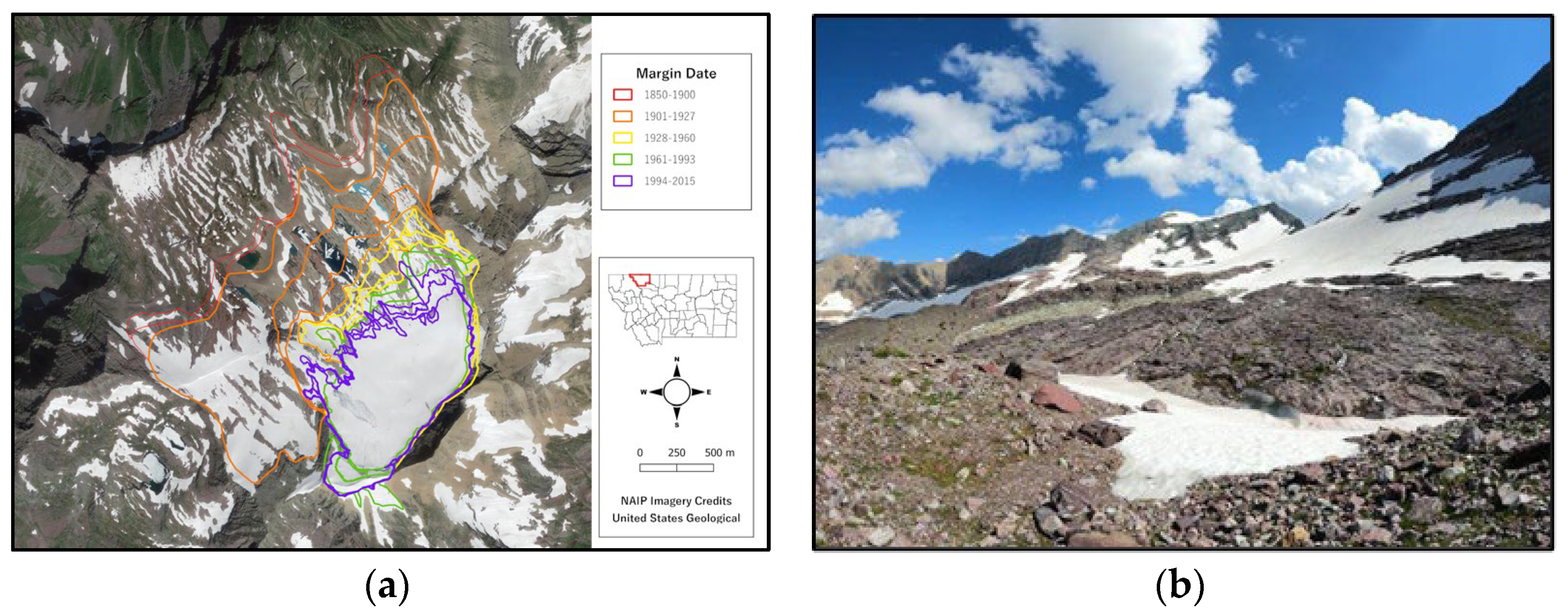
Figure 1. The three phase, seven-step TECCUPD process for VLE development [9].
Education 14 00272 g001
Figure 2. Glaciers with an extent greater than 0.1 km2 (1966 inventory) shown within the Glacier National Park boundary [17].
Education 14 00272 g002
Figure 3. Photo-sphere raw data featuring both the front and back view of Sexton Glacier that are stitched together to create the photo sphere (See map, Figure 2) [15].
Education 14 00272 g003
Figure 4. (ah): Imagery examples used to support contextual application for the lesson extracted from the photo spheres (Sources listed in detail below).
Education 14 00272 g004aEducation 14 00272 g004b
Figure 5. (af): LiDAR examples used to support contextual application for the lesson. LiDAR source: Gielstra [40].
Education 14 00272 g005
Figure 6. (ad): LiDAR measurements taken in Polycam application [40].
Education 14 00272 g006
Figure 7. (a,b) Sexton Glacier map showing changing glacier margins over time (1901–2015) and image taken from fieldwork collection in 2021 [40].
Education 14 00272 g007
Figure 8. (a,b) Grinnell Glacier map showing changing glacier margins over time (1850–2015) and image taken from fieldwork collection in 2021 [40].
Education 14 00272 g008
Figure 9. (a,b) Sperry Glacier map showing changing glacier margins over time (1850–2015) and image taken from fieldwork collection in 2021 [41].
Education 14 00272 g009
Figure 10. (ac) LiDAR scans of Sperry Glacier geologic features: (a) striations; (b) ripple marks; and (c) folding [41].
Education 14 00272 g010
Table 1. Field sites in Glacier National Park, characterized by access distance and difficulty, combined with the inclusion of the glacier area lost since the 1850 Little Ice Age (LIA) extent, and years 1966, 1998, 2005 and 2015. Data source: United States Geological Survey (USGS) [18].
Feature NameHike Distance (Round Trip km)/DifficultyArea LIA (m2)Area 1966 (m2)Area 1998 (m2)Area 2005 (m2)Area 2015 (m2)% Decrease 1850–2015
Grinnell Glacier16.7 km/Strenuous1,976,4941,020,200715,907615,568563,72071.48
Sexton Glacier16.3 km/Difficult528,179400,493324,011312,762298,68143.45
Sperry Glacier29.6 km/Strenuous3,793,3221,339,531953,104888,095801,67078.87
Table 2. Notes on glacial landscape change and the diverse features of a topographically complex glacier landscape.
Examples of the landscape change in glacial landscapesGlacier retreat, moraines, glacial striations and polish, glacial meltwater features, hanging valleys and waterfalls, glacial lakes
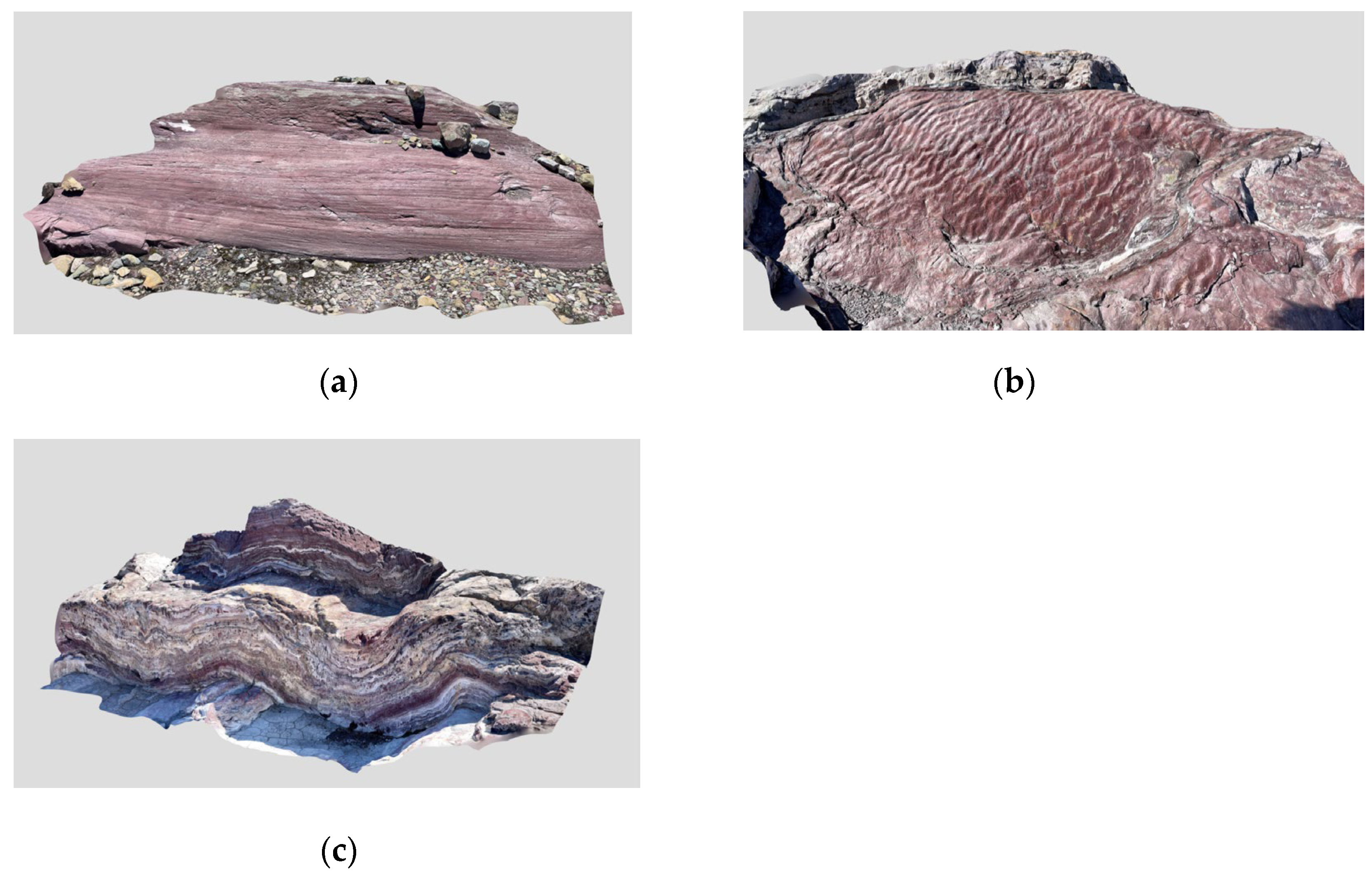
Examples of geodiversity of a topographically complex glacier landscape.Evidence of different physical settings for the glaciers, presence of cliff-edged glaciers, expanse of glacier forefront, lithologic control (gently sloping versus rough terrain), glacial lakes and geomorphic hazard potential, scouring (ice-scour lakes), Little Ice Age moraines, Early Holocene advance (Sperry), extensive field of roche moutonnées, scraped rock, abraded backslopes, different bedrock types, thinly bedded argillite, massively bedded Siyeh limestone, different plucking patterns, different abrasion patterns, striations, rocks responsible for striations still present, crescentic scars, chattermarks, equilibrium line, crevasse, bergschrunds, firn line, glacial till and ground moraine, ice rafting, glacier generated debris flow levees, Cyclopean stairs, meltwater streams. stromatolite fields, debris-covered ice
Table 3. Notes on glacial landscape change and the diverse features of a topographically complex glacier landscape.
Glacier BasinGeodiversity Examples Focused on Geomorphological FeaturesGeodiversity Score
GrinnellGlacier forefront not as massive, Little Ice Age moraines, glacial lakes, geomorphic hazard potential, extensive field of roche moutonnée, scraped rock, abraded backslopes, more developed and variable plucking patterns, less complex lithologic control—gently sloping, scouring (ice-scour lakes), striations, crescentic scars, chattermarks, equilibrium line, crevasse, bergschrunds, firn line, glacial and ground moraine, ice rafting, glacier generated debris flow levees. Cyclopean stair, meltwater streams, stromatolite fields, debris-covered ice70.00
SextonCliff-edged glaciers, geomorphic hazard potential, less-developed plucking patterns, cirque, limited glacier forefront. 65.00
SperryMassive expanse of glacier forefront, Little Ice Age moraines, evidence of Early Holocene advance, more complex lithologic controls, complex and rough terrain, scraped rock, abraded backslopes, more developed and variable plucking patterns, scouring (ice-scour lakes), striations, equilibrium line, crevasse, bergschrunds, firn line, glacial and ground moraine, meltwater streams, ripple marks, debris-covered ice71.25
Table 4. Recommended user-experience considerations for Step 5.
VLE ComponentsConsiderations for User Experience Testing
Learning ObjectivesAccuracy of the learning objectives; the VLE is aligned to the learning objectives
Photo sphere VisualDensity of information on the landscape; density of information within each information point; angle of the visual setting; viability of the desired phenomena; lighting of the visual setting; level of detail available; levels of distortion; obstructions to the visual setting; angle and placement of user’s visible field from each specific location to capture relevant features; user’s required range of motion to engage with the photo sphere
Instructional InterventionsFunctionality of links, videos, Supplementary Materials [10,40]; use of technical terminology; language accessibility for novice learners; logical ordering of the intervention; level of intervention difficulty; land acknowledgement for cultural sensitivity; background geography of the location; discussion of relevance of the experience; explanation of labeling of used tools and resources; citations and references; assessments
Contextual ApplicationConnections and application of knowledge in varied contexts; reflective questions; gamification and/or role play; opportunities for user practice
Disclaimer/Publisher’s Note: The statements, opinions and data contained in all publications are solely those of the individual author(s) and contributor(s) and not of MDPI and/or the editor(s). MDPI and/or the editor(s) disclaim responsibility for any injury to people or property resulting from any ideas, methods, instructions or products referred to in the content.

