The Development of a Prototype for Low Altitude Operations of Unmanned Aircraft Flight Plan Systems
Abstract
1. Introduction
- Airborne conflicts—near-miss incidents between unmanned and manned aircraft, often caused by misidentification with other aerial objects.
- Aircraft upset—the loss of control due to turbulence, incorrect altitude, or excessive payload.
- System failures—technical malfunctions leading to erratic or unsafe behavior.
- Third-party conflicts—collisions or threats to people and property not directly tied to control loss or system malfunctions.
2. Materials and Methods
3. Results
3.1. Findings from Secondary Research
- •
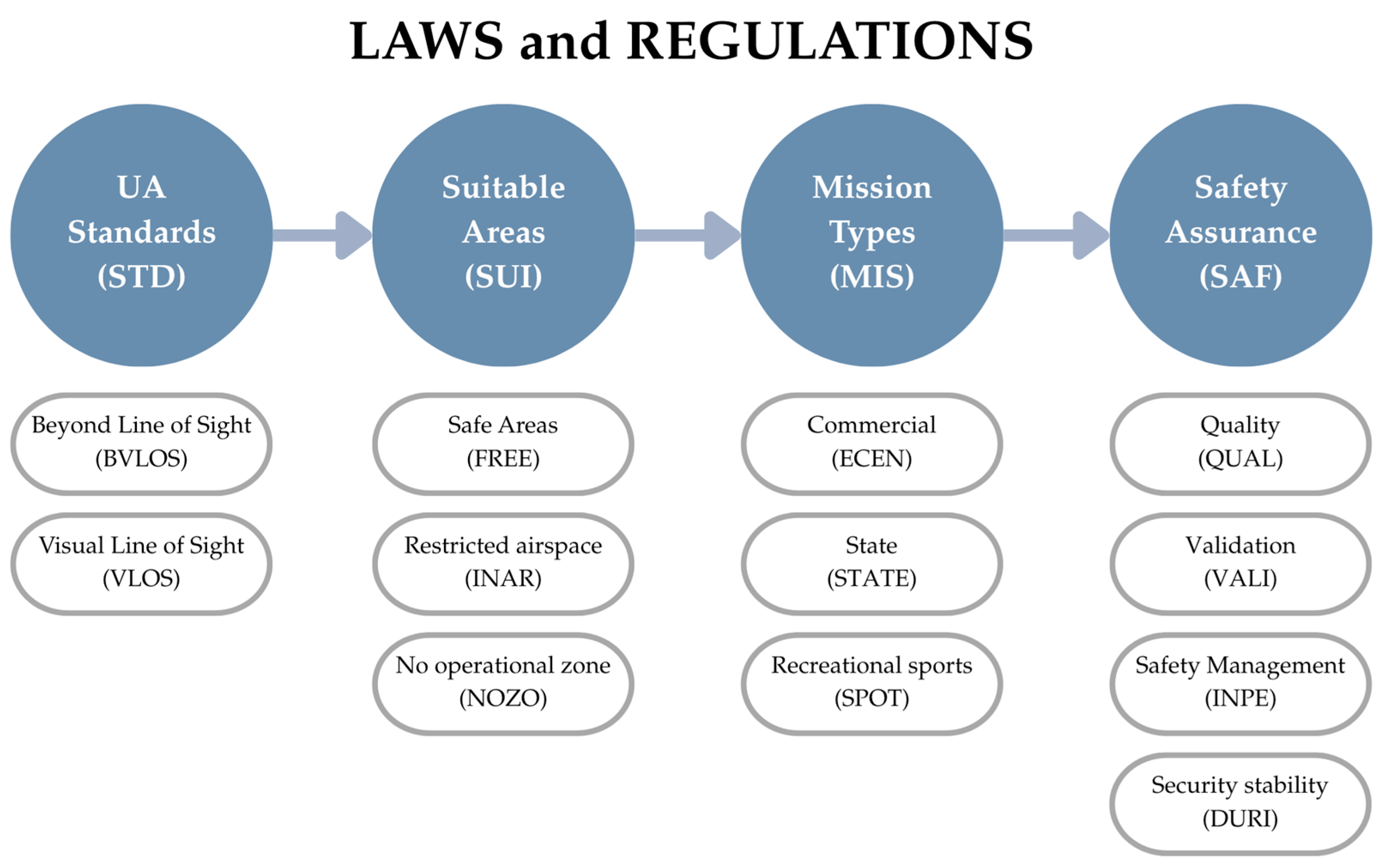
- STD depend on the UA’s performance of that aircraft, which can fly in the Visual Line of Sight (VLOS) and Beyond Visual Line of Sight (BVLOS). The latter requires the use of distance and weather as a criterion. The Extended Visual Line of Sight (EVLOS) is a flight operation in which the commanding pilot cannot see the aircraft directly, but there is a visual observer who constantly observes the aircraft and communicates information with the pilot via radio or other means. In the current case of Thailand, this type of flight is not allowed, as there is not sufficient data to formulate a low altitude flight plan model in this study.
- •
- SUI addresses various operational zones, including safe areas (FREE), restricted airspace (INAR), and no-operation zones (NOZO).
- •
- MIS refers to the types of UA activities, such as commercial (ECEN), state (STATE), or recreational/sport use (SPOT).
- •
- SAF encompasses aspects such as quality assurance (QUAL), validation (VALI), safety management (INPE), and security stability (DURI).
3.2. Findings from Surveys and Interviews
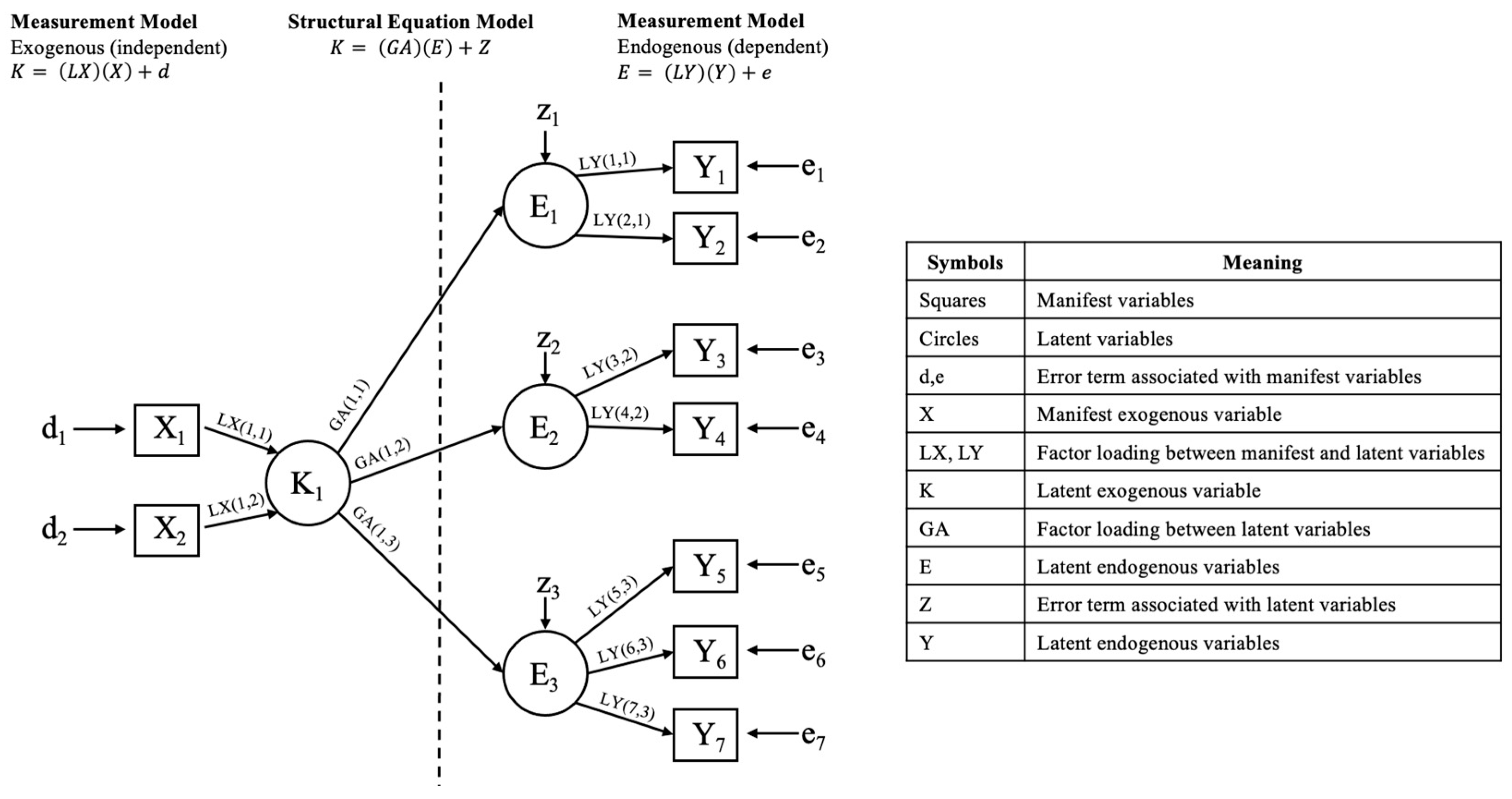
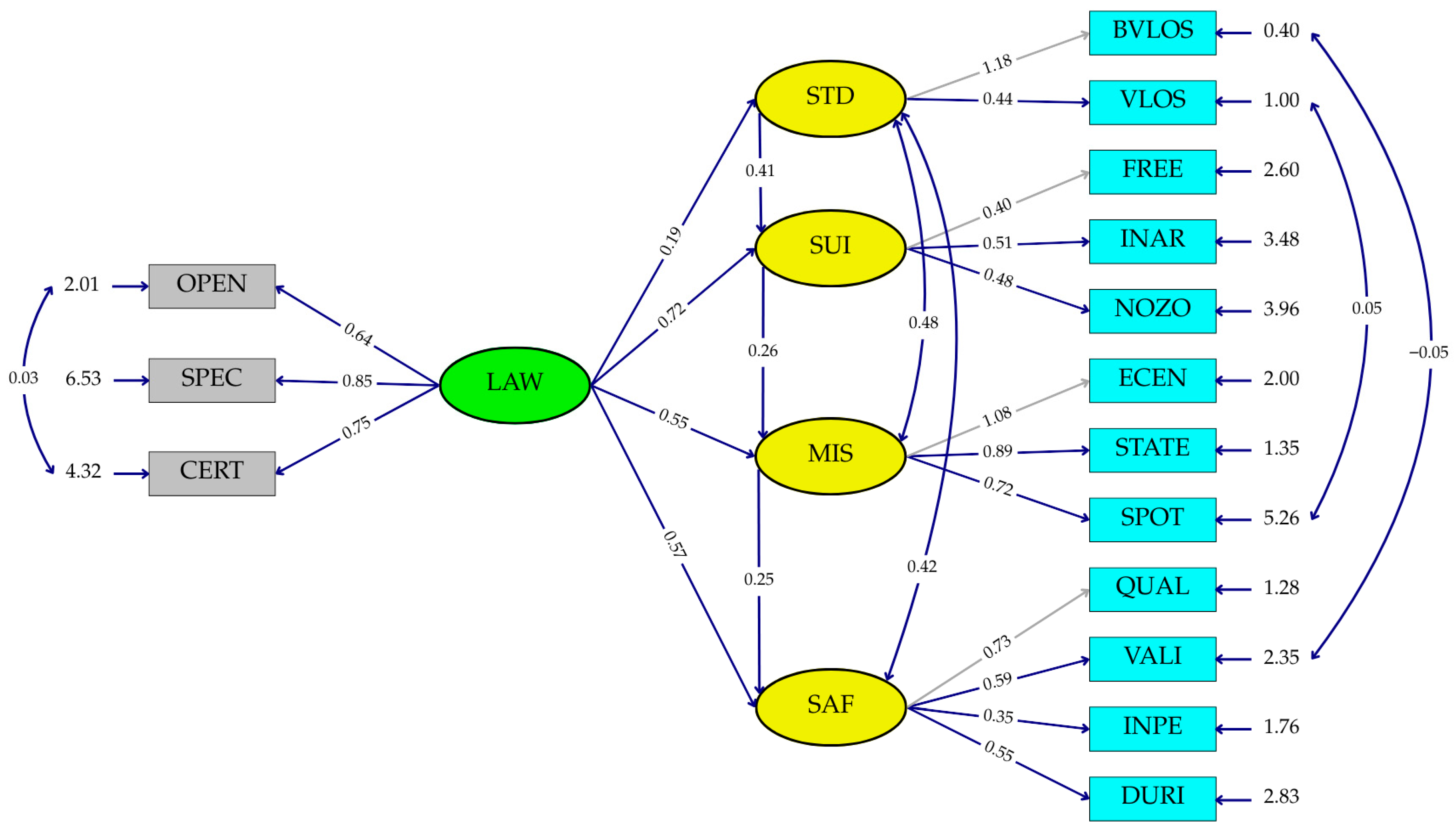
3.3. SEM Analysis
3.4. Flight Plan Prototype for Low Altitude UA Operation
3.5. Website Architecture
- Not localized for non-Western regulatory environment.
- Not lightweighted enough for decentralization deployment at provincial or municipal levels.
- Lacking Thai-language support and context-aware risk management modules.
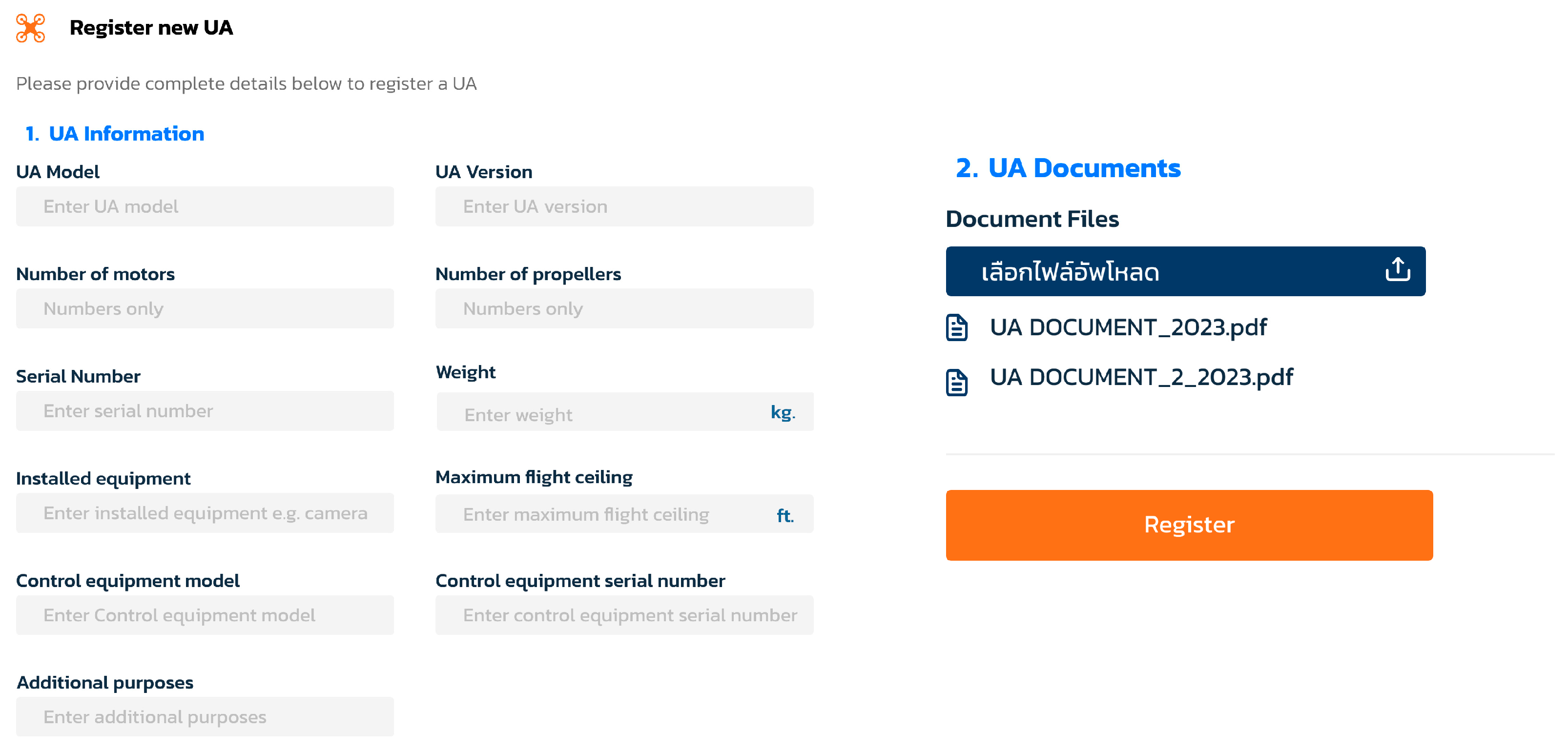
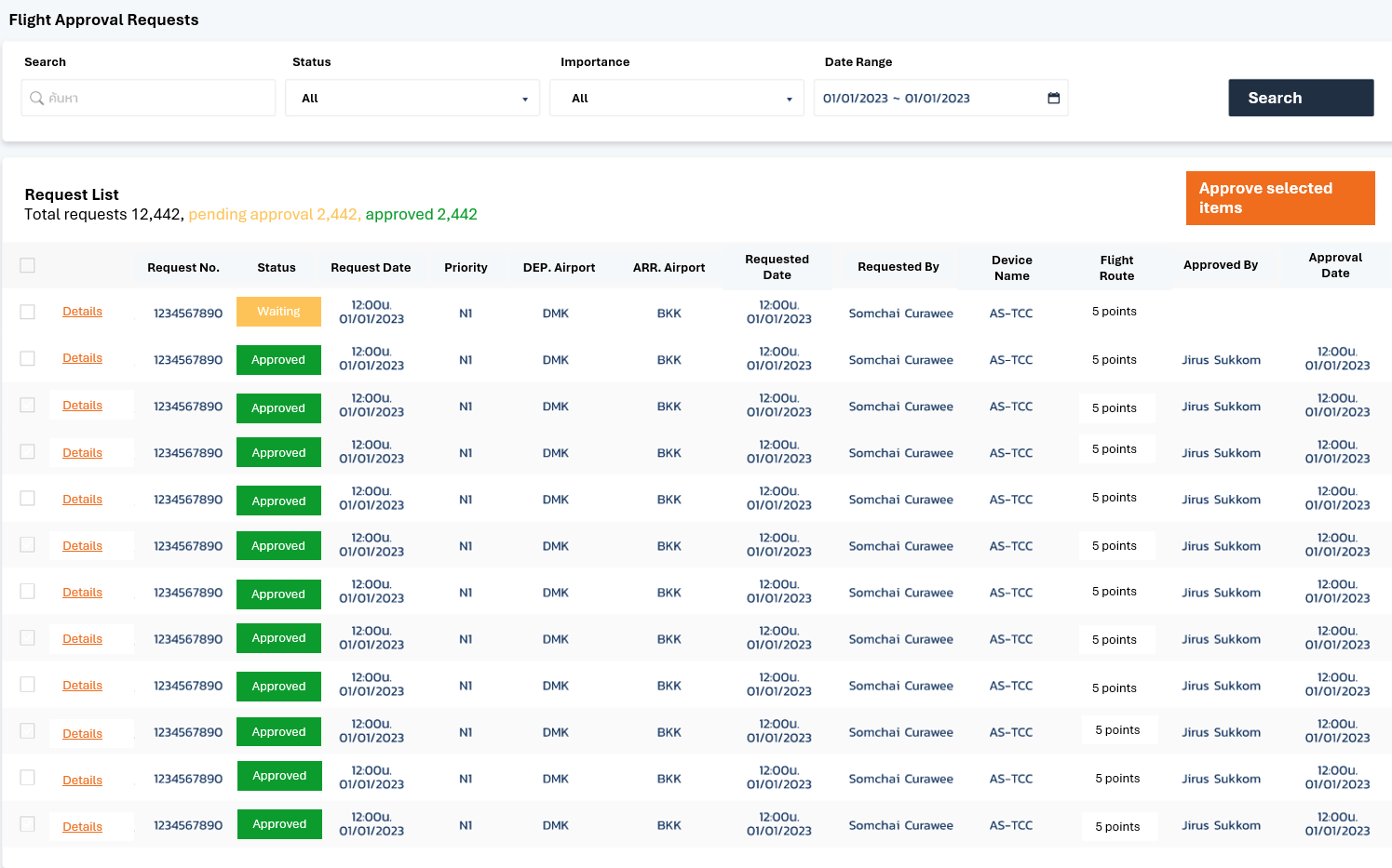
3.6. Website Walkthrough
3.7. Website Testing and Validation
- •
- 95% satisfaction with the user interface;
- •
- 90% agreement that the system reduced paperwork;
- •
- 92% reported better tracking and clarity of flight plan status.
4. Discussion
- Field validation was limited to specific geographic areas within Thailand, which may not capture broader terrain and regulatory diversity. Future work should include expanded field trials across various environments such as urban, coastal, and forested zones to improve the platform’s generalizability and robustness.
- The user evaluation process primarily relied on self-report questionnaires and observational data. Future iterations should incorporate longitudinal user studies and controlled simulations to assess cognitive load, task performance, and situational awareness under varying mission scenarios.
- The current prototype does not yet incorporate machine learning (ML) or artificial intelligence (AI) for route optimization, obstacle avoidance, or battery management. Future research should explore integrating predictive routing, real-time risk assessment, and adaptive behavior models to enhance platform intelligence and autonomy.
5. Conclusions
Author Contributions
Funding
Data Availability Statement
Acknowledgments
Conflicts of Interest
Abbreviations
| AGFI | Adjusted Goodness-of Fit Index |
| ANSP | Air Navigation Service Providers |
| ATC | Air Traffic Controller |
| ATS | Air Traffic Services |
| BVLOS | Beyond Visual Line of Sight |
| CAAT | Civil Aviation Authority of Thailand |
| CFI | Comparative Fit Index |
| EASA | European Union Aviation Safety Agency |
| FAA | Federal Aviation Administration |
| ICAO | International Civil Aviation Organization |
| LISREL | Linear Structural Relation |
| NOTAM | Notice to Airmen |
| RMR | Root Mean Square Residual |
| RMSEA | Root Mean Square Error of Approximation |
| SEM | Structural Equation Model |
| SRMR | Standardized Root Mean Square Residual |
| UA | Unmanned Aircraft |
| UAS | Unmanned Aircraft System |
| USP | Unmanned Aircraft Service Providers |
| UTM | Unmanned Aircraft Traffic Management |
| VLOS | Visual Line of Sight |
References
- Union Aviation Safety Agency (EASA). UAS Safety Risk Portfolio: A Preliminary Assessment of Known Safety Occurrences with Unmanned Aircraft Systems; EASA: Cologne, Germany, 2016; Available online: https://www.easa.europa.eu/sites/default/files/dfu/UAS%20Safety%20Analysis.pdf (accessed on 29 July 2025).
- International Civil Aviation Organization (ICAO). Unmanned Aircraft Systems Traffic Management (UTM) Framework, 4th ed.; ICAO: Montréal, QC, Canada, 2024; Available online: https://www.icao.int/safety/UA/Documents/UTM%20Framework%20Edition%204.pdf (accessed on 29 July 2025).
- FAA. UAS Traffic Management (UTM) Concept of Operations v2.0; FAA: Washington, DC, USA, 2022. Available online: https://www.faa.gov/sites/faa.gov/files/2022-08/UTM_ConOps_v2.pdf (accessed on 29 July 2025).
- Civil Aviation Authority of Thailand (CAAT). Guidance Material CAAT GM UAS 010: Procedures for Unmanned Aircraft Operations; CAAT: Bangkok, Thailand, 2024; Available online: https://uasportal.caat.or.th/guidanceFlight (accessed on 29 July 2025).
- International Civil Aviation Organization (ICAO). Circular 328: Unmanned Aircraft Systems (UAS); ICAO: Montréal, QC, Canada, 2011; Available online: https://www.icao.int/meetings/uas/documents/circular%20328_en.pdf (accessed on 29 July 2025).
- International Civil Aviation Organization (ICAO). Manual on Remotely Piloted Aircraft Systems (RPAS); Doc 10019; ICAO: Montréal, QC, Canada, 2015. [Google Scholar]
- ICAO UAS Panel. The Universal Framework for UAS and UTM Integration. In Proceedings of the ICAO UAS Panel Meeting, Montréal, QC, Canada, 12–14 November 2019; Available online: https://www.icao.int/safety/UA/Documents/UAS-UTM-Framework.pdf (accessed on 29 July 2025).
- Anonymous. Interview with UAS Pilots, Air Traffic Controllers, and Engineers; Internal Report; Transportation Commission of the Thai Senate: Bangkok, Thailand, 2024. [Google Scholar]
- Jöreskog, K.G.; Sörbom, D. LISREL 8: Structural Equation Modeling with the SIMPLIS Command Language; Scientific Software International: Chicago, IL, USA, 1989. [Google Scholar]
- Yenpiem, S.; Yooyen, S.; Banchong-Aksorn, S.; Yoneyama, K.R.; Jansri, A.; Mitrathanun, P. The Development of an Automated Technology for Unmanned Aircraft CNS/UTM in Compliance with Safety and Security Measures of the State. In Proceedings of the 2025 Integrated Communications, Navigation and Surveillance Conference (ICNS), Brussels, Belgium, 8–10 April 2025; pp. 1–10. [Google Scholar] [CrossRef]
- Hair, J.F.; Black, W.C.; Babin, B.J.; Anderson, R.E.; Tatham, R. Multivariate Data Analysis, 7th ed.; Pearson International Edition: Upper Saddle River, NJ, USA, 2010. [Google Scholar]
- Hair, J.F.; Black, W.C.; Babin, B.J.; Anderson, R.E.; Tatham, R. Multivariate Data Analysis, 6th ed.; Pearson International Edition: Upper Saddle River, NJ, USA, 2006. [Google Scholar]
- ICAO. Procedures for Air Navigation Services—Air Traffic Management (PANS-ATM), 16th ed.; Doc 4444; ICAO: Montréal, QC, Canada, 2016. [Google Scholar]
- TIBCO Software Inc. LISREL 10.30 User’s Guide; TIBCO: Palo Alto, CA, USA, 2022; Available online: https://docs.tibco.com (accessed on 29 July 2025).
- Byrne, A. Structural Equation Modeling with EQS and EQS/Windows; Sage Publications: Thousand Oaks, CA, USA, 1994. [Google Scholar]
- Hooper, D.; Coughlan, J.; Mullen, M.R. Structural Equation Modelling: Guidelines for Determining Model Fit. Electron. J. Bus. Res. Methods 2008, 6, 53–60. Available online: https://pmc.ncbi.nlm.nih.gov/articles/PMC4804052/ (accessed on 29 July 2025).
- Hu, L.T.; Bentler, P.M. Cutoff Criteria for Fit Indexes in Covariance Structure Analysis: Conventional Criteria versus New Alternatives. Struct. Equ. Model. 1999, 6, 1–55. [Google Scholar] [CrossRef]
- Kline, P. Evaluating Model Fit in Structural Equation Modeling: The χ2/df Ratio, RMSEA, CFI, and SRMR Thresholds. Psychol. Methods 2010, 15, 137–150. [Google Scholar] [CrossRef]
- Schermelleh-Engel, K.; Moosbrugger, H.; Müller, H. Evaluating the Fit of Structural Equation Models: Tests of Significance and Descriptive Goodness-of-Fit Measures. Methods Psychol. Res. Online 2003, 8, 23–74. [Google Scholar] [CrossRef]
- Kline, R.B. Principles and Practice of Structural Equation Modeling, 4th ed.; Guilford Press: New York, NY, USA, 2015. [Google Scholar]
- Tanaka, J.S.; Huba, G.J. A Fit Index for Covariance Structure Models under Arbitrary GLS Estimation. Br. J. Math. Stat. Psychol. 1985, 38, 197–201. [Google Scholar] [CrossRef]
- NASA; FAA. UTM Conflict Management Model v2.0; NASA Technical Documents: Washington, DC, USA, 2020. Available online: https://ntrs.nasa.gov/api/citations/20200002962/downloads/UTM_Conflict_Management_Model.pdf (accessed on 29 July 2025).



| Category of Operation | Risk Level | Characteristics |
|---|---|---|
| Open | Low | Unrestricted, visually observed, low altitude, low speed, operating in open areas, and include activities such as sports or state aircraft. |
| Specific | Medium | Extended flight duration, not visible by sight, operating in uncontrolled or overpopulated areas, and weighing less than 25 kg. |
| Certified | High | Operating in dense area, high altitude, commercial service mission, flying in shared airspace with other aircraft or group flights, and weighing more than 25 kg. |
| Aspect | Flight Plan for Manned Aircraft | Low Altitude Flight Plan for UA |
|---|---|---|
| Flight plan | Requires ICAO format flight plan submission via ATS systems. | Often does not require a formal flight plan. May use simplified or informal submission procedure. |
| Presence of pilot | Requires pilot onboard for operation. | No pilot onboard, operated remotely or autonomously. |
| System operation | Communications, Navigation, and Surveillance (CNS)/Air Traffic Management (ATM). | Internet, cellular connectivity (4G/5G), Wi-Fi, or satellite links to connect to cloud or remote servers. |
| Remote Identification and tracking | Surveillance system such as radar system, Automatic Dependent Surveillance–Broadcast and Wide Area Multilateration. | Remote ID, cloud-based system, and 4G/5G network. |
| Flight rule operation | General rule, Visual Flight Rule, or Instrument Flight Rule. | General rule, Visual Line of Sight (VLOS), and Beyond Visual Line of Sight (BVLOS) |
| Crew | Typically requires a crew consisting of pilots, co-pilots, and possibly flight engineers. | No crew onboard. Controlled by operators on the ground. |
| Training | Requires extensive training for pilots and crew members. | Requires training for operators, but less extensive compared to manned aircraft pilots. |
| Altitude range | Usually 3000–46,000 feet Above Mean Sea Level. | Ground level to 500 feet or 200 feet Above Mean Sea Level. |
| Flight phase and landing system | Performance-based Navigation, air traffic control communication protocols between pilots and air traffic controllers (ATC), VHF Omnidirectional Range, and Instrument Landing System. | Ground-based or satellite communication reliance on data links (either non-traditional ground-based links, C2 Links or data links associated with UTM systems). |
| Weather considerations | High-altitude weather conditions and jet streams. | Micro-weather. |
| Flight duration | Long durations with possible fuel refueling. | Shorter duration, limited by battery life or capacity. |
| Navigation | Uses avionics systems such as Required Navigation Performance and Performance-based Navigation. | Relies on GNSS and other sensors. |
| Emergency response | Pilots can respond to emergencies in real-time and may have access to better resources. | May require fail-safes for autonomous operation and contingency planning for loss of communication. |
| Airspace restrictions | Subject to airspace regulations and restrictions, including controlled airspace and restricted areas. | May have restrictions when flying near airports, populated areas, or areas with infrastructures. |
| Mission duration | Limited by crew fatigue, fuel capacity, and other factors. | Longer durations due to reduced need for rest periods and more efficient fuel consumption in some cases. |
| Flight planning complexity | More complex flight planning due to longer distances, higher altitudes, and ATM considerations. | Simplified flight planning due to lower altitudes and typically shorter flight distances. |
| Operational procedures | Follows ICAO/ATC protocols, including standard operating procedures and contingency protocols coordinated with ATC. | Requires UTM and ATM specific operational procedures including normal, contingency, and emergency scenario, supported by automated functions. |
| Air traffic service | ANSP | Currently undefined USPs. |
| Law and regulations | ICAO Chicago Convention and national civil aviation regulations, with detailed provisions for pilot licensing, airworthiness, and ATM integration. | National-level UAS-specific regulations, often outside the ICAO Annexes. Include rules for registration, remote pilot certification, VLOS/ BVLOS operations, Remote ID, and UTM system integration. |
| Data recording | ATC data retention and aircraft flight recorder requirements. | Non-specific flight recording system. |
| Variables | Co-Efficient | Types of Influence |
|---|---|---|
| LAW on STD | 0.19 | Direct |
| LAW on SUI | 0.72 | Direct |
| LAW on MIS | 0.55 | Direct |
| LAW on SAF | 0.57 | Direct |
| LAW on SUI through STD | 0.19 × 0.41 = 0.08 | Indirect |
| LAW on MIS through STD and SUI | 0.19 × 0.41 × 0.26 = 0.02 | Indirect |
| LAW on SAF through STD, SUI, and MIS | 0.19 × 0.41 × 0.26 × 0.25 = 0.01 | Indirect |
| LAW on MIS through STD | 0.19 × 0.48 = 0.09 | Indirect |
| LAW on SAF through STD | 0.19 × 0.42 = 0.08 | Indirect |
| Name of Category | Index Name | Level of Acceptance | Value | Results | Model Interpretation |
|---|---|---|---|---|---|
| Parsimonious fit | χ2/df | <2 | 1.082 | Qualified [13,14,15] | Good fit. |
| Absolute fit | p-value | >0.05 | 0.229 | Qualified [13,14] | Consistent. |
| GFI | >0.95 | 0.97 | Qualified [16] | Harmonious. | |
| RMSEA | <0.08 | 0.015 | Qualified [17] | Consistent with empirical data. | |
| RMR | ≤0.05 | 0.012 | Qualified [17] | Has squared average of remainder. | |
| SRMR | ≤0.05 | 0.04 | Qualified [17] | Consistent. | |
| Incremental fit | CFI | >0.95 | 0.98 | Qualified [18,19] | Consistent with empirical data. |
| AGFI | >0.95 | 0.97 | Qualified [18,19] | Harmonious when adjusted. |
| Features | NASA TCL | SESAR U-Space | FAA Federated | ICAO OSAM | GoFly |
|---|---|---|---|---|---|
| Open-source availability | ✖ | ✖ | ✖ | ✖ | ✔ |
| Local policy adaptation | ✖ | ✖ | ✔ | ✔ | ✔ |
| Thai language interface | ✖ | ✖ | ✖ | ✖ | ✔ |
| Risk-based auto-approval | ✔ | ✔ | ✔ | ✔ | ✔ |
| Modular microservices | ✔ | ✔ | ✔ | ✔ | ✔ |
| Integrated CFA/SEM | ✖ | ✖ | ✖ | ✖ | ✔ |
| Metric | Threshold | Results | Status |
|---|---|---|---|
| API latency | <100 ms | 87 ms | ✔ |
| Risk module accuracy | >90% | 96% | ✔ |
| Uptime (72 h) | >99% | 100% | ✔ |
Disclaimer/Publisher’s Note: The statements, opinions and data contained in all publications are solely those of the individual author(s) and contributor(s) and not of MDPI and/or the editor(s). MDPI and/or the editor(s) disclaim responsibility for any injury to people or property resulting from any ideas, methods, instructions or products referred to in the content. |
© 2025 by the authors. Licensee MDPI, Basel, Switzerland. This article is an open access article distributed under the terms and conditions of the Creative Commons Attribution (CC BY) license (https://creativecommons.org/licenses/by/4.0/).
Share and Cite
Yenpiem, S.; Yooyen, S.; Tungkasthan, A.; Banchongaksorn, S.; Yoneyama, K.R. The Development of a Prototype for Low Altitude Operations of Unmanned Aircraft Flight Plan Systems. Aerospace 2025, 12, 826. https://doi.org/10.3390/aerospace12090826
Yenpiem S, Yooyen S, Tungkasthan A, Banchongaksorn S, Yoneyama KR. The Development of a Prototype for Low Altitude Operations of Unmanned Aircraft Flight Plan Systems. Aerospace. 2025; 12(9):826. https://doi.org/10.3390/aerospace12090826
Chicago/Turabian StyleYenpiem, Siriporn, Soemsak Yooyen, Anucha Tungkasthan, Sasicha Banchongaksorn, and Keito R. Yoneyama. 2025. "The Development of a Prototype for Low Altitude Operations of Unmanned Aircraft Flight Plan Systems" Aerospace 12, no. 9: 826. https://doi.org/10.3390/aerospace12090826
APA StyleYenpiem, S., Yooyen, S., Tungkasthan, A., Banchongaksorn, S., & Yoneyama, K. R. (2025). The Development of a Prototype for Low Altitude Operations of Unmanned Aircraft Flight Plan Systems. Aerospace, 12(9), 826. https://doi.org/10.3390/aerospace12090826


