Article

The Development of a Prototype for Low Altitude Operations of Unmanned Aircraft Flight Plan Systems

by
Siriporn Yenpiem
1,
Soemsak Yooyen
1,*,
Anucha Tungkasthan
2,*,
Sasicha Banchongaksorn
1 and
Keito R. Yoneyama
1
1
International Academy of Aviation Industry, King Mongkut’s Institute of Technology Ladkrabang, Bangkok 10520, Thailand
2
Computer Technology, Rajamangala University of Technology Thanyaburi, Pathum Thani 12110, Thailand
*
Authors to whom correspondence should be addressed.
Aerospace 2025, 12(9), 826; https://doi.org/10.3390/aerospace12090826
Submission received: 4 August 2025 / Revised: 10 September 2025 / Accepted: 12 September 2025 / Published: 15 September 2025
(This article belongs to the Special Issue Flight Guidance and Control)

Abstract

The use of Unmanned Aircraft has grown significantly in Thailand and worldwide, particularly for operations below 450 feet. However, unlike manned aviation, there remains a lack of integrated digital platforms to manage flight plans that align with regulatory and operational requirements specific to low altitude activity. This study employed both secondary research and expert interviews to gather technical and regulatory user requirements. The data were analyzed and validated using Structural Equation Modeling to identify key variables influencing safety operations. Based on these findings, a standardized low altitude flight plan format was developed and converted into a prototype web platform called GoFly. The system enables operators to register aircraft and pilot credentials and to submit flight plans digitally. This platform addresses the current fragmentation in Thailand’s flight planning process by centralizing operations and enhancing regulatory compliance. The study contributes to the foundational development of a digital Unmanned Aircraft Traffic Management system tailored for emerging airspace users in Thailand and demonstrates potential scalability to other international regulatory contexts.

1. Introduction

Unmanned Aircraft (UA) have gained popularity across sectors that require operations in low altitudes such as agriculture, logistics, and surveys. To ensure safe and compliant integration, this has become a pressing issue in Thailand. Their increasing deployment, particularly at altitudes below 150 m above ground level, has brought significant benefits but also introduced regulatory, technical, and safety challenges. An analysis conducted by the European Union Aviation Safety Agency (EASA) on data relating to accidents from 2010 to 2016 highlighted four major categories of risk persisting in UA operations [1]:
  • Airborne conflicts—near-miss incidents between unmanned and manned aircraft, often caused by misidentification with other aerial objects.
  • Aircraft upset—the loss of control due to turbulence, incorrect altitude, or excessive payload.
  • System failures—technical malfunctions leading to erratic or unsafe behavior.
  • Third-party conflicts—collisions or threats to people and property not directly tied to control loss or system malfunctions.
In many countries, including Thailand, the issues regarding these major categories of risk are further exacerbated by the absence of a centralized and automated Unmanned Aircraft Traffic Management (UTM) system, especially in areas such as flight plan submission and coordination with regulatory authorities [2]. The global aviation community has acknowledged the urgency of addressing these issues. As a result, the International Civil Aviation Organization (ICAO), EASA, Federal Aviation Administration (FAA), and Thailand’s own legislative bodies have all emphasized the need for well-regulated Unmanned Aircraft System (UAS) integration. The ICAO framework including the Chicago Convention annexes lays the foundation for harmonized aviation standards worldwide, calling for all aircraft, manned or unmanned, to submit flight plans in accordance with national regulations [3,4,5,6,7,8].
However, in Thailand, the supporting infrastructure, regulatory mechanisms, and flight plan procedures remain underdeveloped. At present, most UA flight planning processes are handled through fragmented or manual systems, resulting in delays and inconsistencies. Moreover, operators often lack access to a centralized platform for UTM.
To understand the intricate UAS and find ways to minimize the persisting risks, Structural Equation Modeling (SEM) was adopted. SEM is a multivariate statistical technique used to examine relationships among multiple variables. It is a popular tool for hypothesis testing, model assessment, and understanding scenarios with complex interconnections as it helps to explain and predict phenomena. SEM allows researchers to analyze complex relationships based on measurement or structural roles. Measurement variables include measured (observed) and latent (unobservable) variables. Structural roles include exogenous and endogenous variables. As a result, SEM is particularly useful for studying UAS and traffic management (UTM) due to the interaction of technical, regulatory, and operational components. It enables researchers to model causal relationships and explore the influence of factors such as airspace safety, service quality, and regulatory compliance readiness [7].
A tool for SEM implementation that focuses solely on analyzing relationships among latent variables was developed by Jöreskog and Sörbom, namely Linear Structural Relation (LISREL). LISREL is a statistical software package used for estimating coefficients and testing hypothesis about relationships between variables by utilizing two key models, the measurement model and a part of the SEM [9]. The measurement model describes how latent variables, both exogenous and endogenous, are measured by observed variables. The latter model describes the relationships among latent variables, representing causal paths and dependencies. Using this software for SEM analysis, the output is shown in Figure 1 along with the symbols and their corresponding meanings.
The purpose of this study was to develop a model of the UA flight planning system in low altitude flight: linear structure equations. To determine the important influence characteristics that affect the determination of the Unmanned Aircraft flight plan in flying at an altitude of up to 450 feet, empirical data was used from a sample of aviation personnel. The participants had specific knowledge and experience in aviation to confirm the flight planning theory before applying the flight planning system model in the automated flight plan system. This manuscript is related to our other research entitled, “The Development of an Automated Technology for Unmanned Aircraft CNS/UTM in Compliance with Safety and Security Measures of the State” [10].

2. Materials and Methods

The methodology employed in this study consists of both secondary and primary research to gather user requirements from technical and regulatory perspectives. Secondary research involved reviewing international UTM systems and flight planning documentation and identifying existing gaps in current practices. Key documents referenced include ICAO Doc 4444 [4], UTM guidelines [5], flight permit guidance material [6], and UAS documentation [7].
Primary research involved structured interview questionnaires with aviation professionals from various organizations to capture their perspectives and user requirements. Examples of these organizations included transportation authorities, UA operators, and commercial airlines. Participant recruitment was primarily based on age; as statistical calculations indicated that age did not significantly influence the determination of STD and SUI, but did show significant differences in MIS and SAF. In contrast, when results were classified by gender, no significant differences were observed across any of the examined aspects. Each interview lasted approximately 30–60 min. The questionnaire consisted of 30 items, divided into 5 general questions and 25 items specifically related to the objectives of this study.
The information collected from both research methods was used as input for SEM analysis to identify causal relationships and determine the key variables necessary for ensuring the safe operation of UA at low altitudes. These insights were combined to develop a prototype for the low altitude flight plan format.
Subsequently, the designed flight plan and SEM results were translated into website specifications, and a UX/UI wireframe was created to visualize the website’s structure.
Based on data-driven requirement specifications, the system design process began with a complete software architecture plan around four component specifications: account and role management, aircraft registration, flight plan submission, and approval workflow.

3. Results

3.1. Findings from Secondary Research

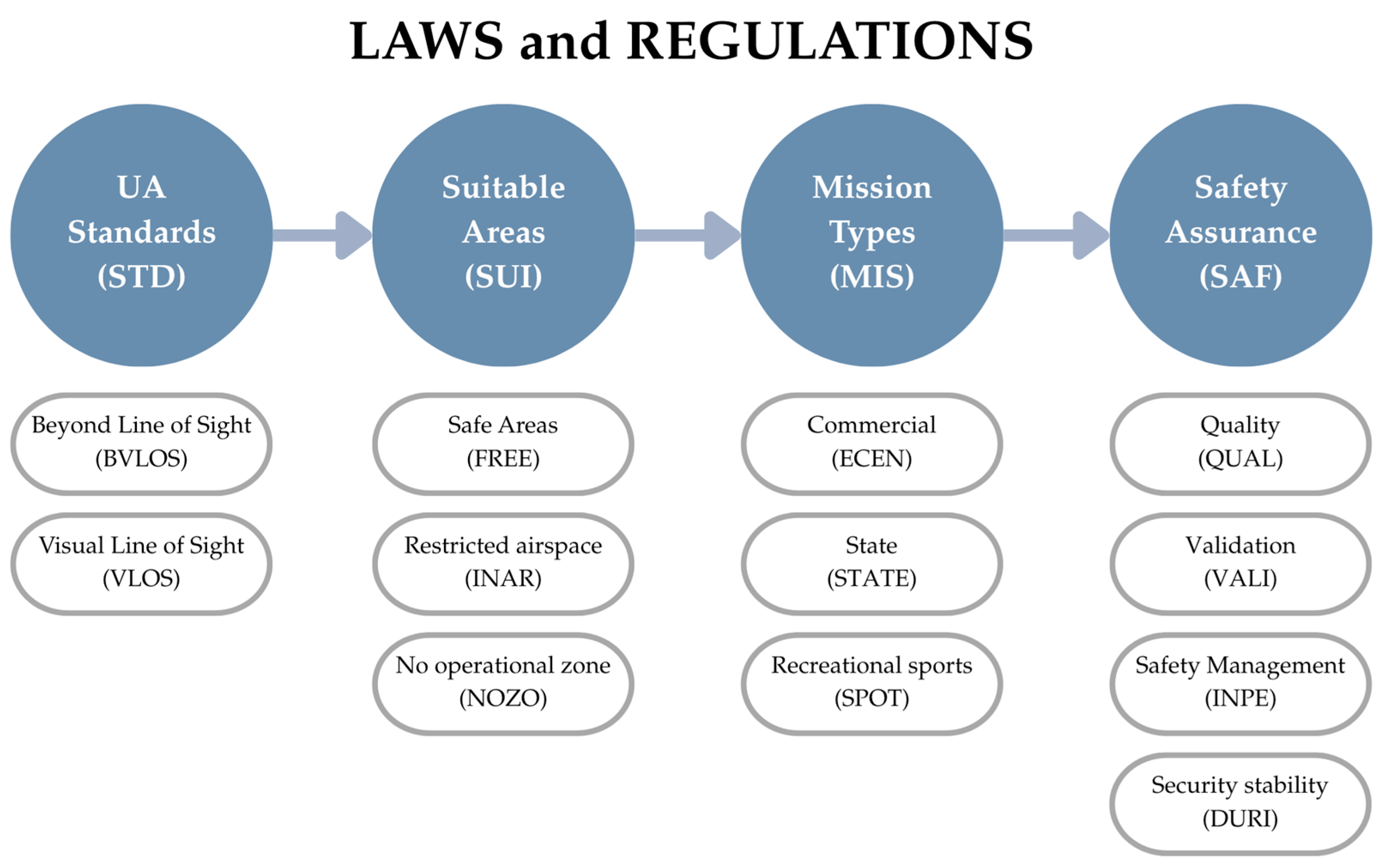
Secondary research revealed that UA Standards (STD), Suitable Areas (SUI), Mission Types (MIS), and Safety Assurance (SAF) are critical factors to consider when constructing a flight plan to ensure operational safety [5,6,7,8]. These factors can be further divided into the following components, as illustrated in Figure 2:
STD depend on the UA’s performance of that aircraft, which can fly in the Visual Line of Sight (VLOS) and Beyond Visual Line of Sight (BVLOS). The latter requires the use of distance and weather as a criterion. The Extended Visual Line of Sight (EVLOS) is a flight operation in which the commanding pilot cannot see the aircraft directly, but there is a visual observer who constantly observes the aircraft and communicates information with the pilot via radio or other means. In the current case of Thailand, this type of flight is not allowed, as there is not sufficient data to formulate a low altitude flight plan model in this study.
SUI addresses various operational zones, including safe areas (FREE), restricted airspace (INAR), and no-operation zones (NOZO).
MIS refers to the types of UA activities, such as commercial (ECEN), state (STATE), or recreational/sport use (SPOT).
SAF encompasses aspects such as quality assurance (QUAL), validation (VALI), safety management (INPE), and security stability (DURI).
Furthermore, Thailand’s aviation ecosystem has begun to adapt UAS operations through the Civil Aviation Authority of Thailand (CAAT), which published the CAAT-GM-UAS-010 guidelines [4,8]. This documentation emphasizes the essential elements such as registration procedure, risk-based approval, and environmental considerations. However, the current approval flight plan workflow remains primarily manual, which hinders the operational efficiency, transparency, and stakeholders’ coordination.
According to ICAO standards, which has been adapted in the Thai regulatory context, there are three risk levels based on the category of operation, open, specified, and certified, in order of increasing risk. The characteristics and corresponding risk levels of each operation category are presented in Table 1.

3.2. Findings from Surveys and Interviews

The stratified random sampling method was used to recruit participants from the aviation field. The strata were based on individuals from various organizations including the Transportation Commission of the Senate, UA operator groups, airlines, and Air Navigation Service Providers. From the initial 400 participants, 215 were chosen, aged 25 and above with more than 5 years of domestic and international work experience. From the results of the data analysis of a sample of 215 people with verified data and statistical analysis, it was found that 130 respondents were male, accounting for 60.5%, and 85 were female, accounting for 39.5%. Most of the respondents had a bachelor’s degree, accounting for 50.3%, some had a master’s degree, accounting for 29.7%, and others had a doctoral degree, accounting for 20.0%, respectively.
The analysis of the SEM with a sample size of 215 is sufficient for all variables in the equation to follow a normal distribution, as can be observed from the values of skewness (SK) and kurtosis (KU). The study results show that both values are close to zero, indicating that all variables in the equation are normally distributed. Therefore, using a sample size of 215 is adequate for conducting the analysis. The empirical data was obtained for analyzing SEM [11,12].
The participants were mainly asked about various aspects for both manned aircraft and low altitude UA operations. The interview sessions revealed that the flight planning procedures for manned aircraft follow a structured process governed by ICAO [13], including a standardized flight planning form, and is supervised by the Air Traffic Service (ATS) system [2,5,10]. In contrast, current procedures for low altitude UA operations are simple and lack a formal flight plan or submission process. Additionally, the ATS for manned aircraft aligns with an Air Navigation Service Provider (ANSP), whereas UA operations are managed by undefined UTM Service Providers (USP). Manned aircraft operations involve more restrictions and regulations to ensure safety, while restrictions for UA depend on the area of operation. Both types of aircraft operation require training and licensing. The requirements for manned aircraft are, however, more extensive and thorough. Other aspects collected from the interview are summarized in Table 2.
Manned aircraft benefit from an established system and highly qualified operators, contributing to safer operations. In contrast, UA operations lack a formal planning system and licenses, which are easier to obtain, revealing a regulatory gap that must be addressed to ensure safety.
Further interviews were conducted focusing on aviation-related risks in connection with STD, SUI, MIS, and SAF as well as on the approval of flight operation requests in the form of flight plans. These can be used to validate the origin of the modeling patterns in the low-level flight SEM.

3.3. SEM Analysis

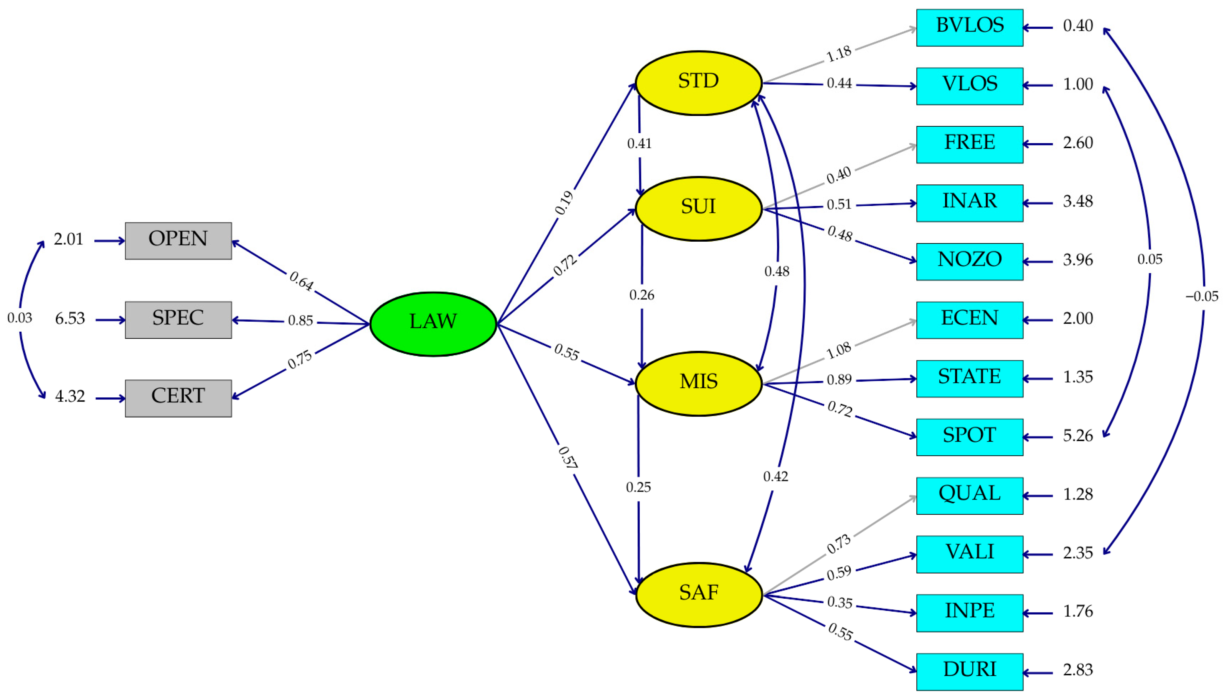
The latent and measured variables from Table 1 and Table 2 were used as input in the LISREL software for SEM analysis [14,15]. The resulting output is presented in Figure 3.
Figure 3 illustrates that laws and regulations (LAW) exert direct and indirect influences on the four key mediating constructs that significantly influence the flight planning of low altitude UA operations. These constructs include STD, SUI, MIS, and SAF, which demonstrate varying levels of direct influence, with SUI having the strongest standardized path coefficient (0.72), followed by SAF (0.57), MIS (0.55), and STD (0.19). Additionally, LAW also has five positive indirect influences. For examples, LAW indirectly influences SUI through STD (0.41) and MIS through STD and SUI (0.48). The other indirect influences are shown in Table 3.
The figure also showed that LAW has a direct and proportional relationship with the three tiers of risk classification, CERT (certified operations or high-risk level) (0.75), SPEC (specific operations or medium risk level) (0.85), and OPEN (open category operations or low risk level) (0.64).
Twelve measured variables represent critical dimensions for ensuring safe and efficient UA operations. For example, BVLOS operations exhibit a stronger impact on STD with a coefficient of 1.18, compared to VLOS (0.44). SUI is primarily influenced by INAR (0.51), followed by NOZO (0.48) and FREE (0.40). Similarly, MIS is significantly affected by ECEN (1.08), STATE (0.89), and SPOT (0.72). The key influence observed variables for SAF include QUAL (0.73), VALI (0.59), DURI (0.55), and INPE (0.35). All these relationships are summarized in Table 3 below.
To verify the statistical significance of the model, various goodness-of-fit indices were calculated, including parsimonious, absolute, and incremental fit, as shown in Table 4. Parsimonious fit indices assess whether the model achieves a good fit using the fewest possible parameters. A widely used index is Chi-square divided by degrees of freedom (χ2/df or CMIN/DF). In this study, the calculated value was 1.082, which is well below the recommended threshold of 2, indicating that the model is efficient and not overfitted [13].
Absolute fit indices evaluate how well the model reproduces the observed data without referencing alternative models. These include the p-value, Goodness-of-Fit Index (GFI), Root Mean Square Error of Approximation (RMSEA), Root Mean Square Residual (RMR), and Standardized Root Mean Square Residual (SRMR). The model yielded a p-value of 0.229, which is greater than the 0.05 threshold, suggesting a good fit. The GFI value was 0.97, approaching the maximum value of 1, indicating a highly compatible model. The RMSEA was 0.015, which falls well within the acceptable range of 0.05–0.08. The RMR and SRMR values were 0.012 and 0.04, respectively, both under the 0.05 cutoff, further confirming the model’s fit.
The incremental fit indices compare the model to a baseline model to assess improvement. The Comparative Fit Index (CFI) and Adjusted Goodness-of-Fit Index (AGFI) were computed. An AGFI value greater than 0.95 indicates a good model fit; the model achieved 0.97. Similarly, the CFI was 0.98, exceeding the 0.95 threshold, further validating the model’s adequacy. This model can be applied to explore the relationships between measured and latent variables involved in low altitude UA flight planning.
In summary, this study found that LAW has both a direct and indirect influence on key components of UA flight plan design. Specifically, there is a positive direct influence on SUI, SAF, MIS, and STD, respectively. Indirect influences are also found between all the four key components. Consequently, the model reinforces the need to prioritize variables with the strongest path coefficients when designing future flight plan prototypes as they exert the greatest influence on operational safety, usability, and mission success.

3.4. Flight Plan Prototype for Low Altitude UA Operation

According to the ICAO guidance material for UA flight plan documentation [2,5,10] and findings from SEM analysis, a new flight plan prototype was developed, as illustrated in Figure 4. Sections A and C requested information similar to that of manned aircraft flight plans, including address, filing time, originator, specific identification of the addressee(s) or originator, aircraft identification, and details about the person filing the plan, the recipient, and any additional remarks. However, the main differences are observed in Section B, which covers questions 8–18. The flight rule/type of operation (Question 8) is notably presented as a checkbox format, in contrast to the text-based input used in manned flight plans. The same format applies to equipment details (Question 10). This is because the operation is completely different, as shown by Table 2. Furthermore, the UA flight plan is requested for the take-off point (Question 13) rather than the departure aerodrome, including only one landing point (Question 16), whereas the manned aircraft flight plan requires details for both alternate and second alternate aerodromes. Finally, Question 18, “Other Information,” requests additional parameters not required in manned aircraft flight plans.
As revealed through interviews and SEM analysis, significant differences exist between the two types of flight plan formats. The UA flight plan requires more specific parameters and relies solely on the manned aircraft format when seeking permission to operate UA. The safety of the flight plan could be compromised if critical information is missed. The proposed prototype is not only user-friendly but also ensures that all essential parameters for safe and efficient UA operations are systematically incorporated.

3.5. Website Architecture

The GoFly website was designed to directly address the following gaps that exist with most platforms:
  • Not localized for non-Western regulatory environment.
  • Not lightweighted enough for decentralization deployment at provincial or municipal levels.
  • Lacking Thai-language support and context-aware risk management modules.
GoFly incorporates structural features from NASA and ICAO but tailored to Thai regulatory workflow and operational behaviors. The architecture is built on three foundational technologies which have been proved to support scalability, modularity, and security: Microservice Architecture (MSA), Single Page Application (SPA), and API Gateways.
MSA enables the system to be developed as a collection of independently deployable services, each responsible for a specific domain function which supports modular development, service isolation, and continuous integration/deployment. Essentially, it separates the frontend and backend functionalities which enable each service to be developed, deployed, and maintain independently. In the context of the GoFly website, aircraft registration, flight planning, document handling, and approval workflows were all independently packaged and containerized. This was achieved through the usage of Docker containers called Docker Swarms to orchestrate service distribution across nodes and IPVS (IP Virtual Server) to manage load balancing. This containerized environment improves scalability, fault tolerance, and version management, ensuring high availability of the platform.
SPA dynamically updates only specific parts of the interface using JavaScript. This reduces page reloads and provides a smoother, more application-like experience for users. By combing this framework with React.js, the frontend dynamically renders only relevant components based on user interaction, eliminating full-page reloads and enabling mobile responsiveness. This is especially important for UA operators who require immediate feedback and fluid system performance during mission-critical operations.
The API Gateway used RESTful API for communication between back- and frontend. NGINX was used for managing authentication, routing, and traffic controls between frontend clients, internal microservices, and external third-party systems. To ensure safe data communication, token-based access framework (OAuth2/OpenID Connect) service discovery was used. Together, these technologies establish a robust technical foundation that allows GoFly to meet the operational demands of airspace management while remaining adaptable to future needs.
Table 5 shows the comparison between other types of global UTM architecture with the developed GoFly website. It shows that the GoFly platform uniquely incorporates features specifically tailored to the localized Thai context, which is absent from other leading UTM architecture. While systems such as NASA’s TCL and SESAR U-space focus on scalability and modularity, they are not designed for decentralized deployment, nor do they offer local language integration. This hybrid approach effectively bridges the gap between global best practices and national operational realities.

3.6. Website Walkthrough

This research indicates that the current flight planning system in Thailand is a manual and fragmented procedure. To address this, the study proposed a web-based system (GoFly) to automate and centralize this process globally.
To begin, Figure 5A illustrates the login page, where UA operators are required to either log in or register for a new account. Figure 5B shows the registration page for new users, which requires operators to provide information such as email, username, password, address, identification number, among other details.
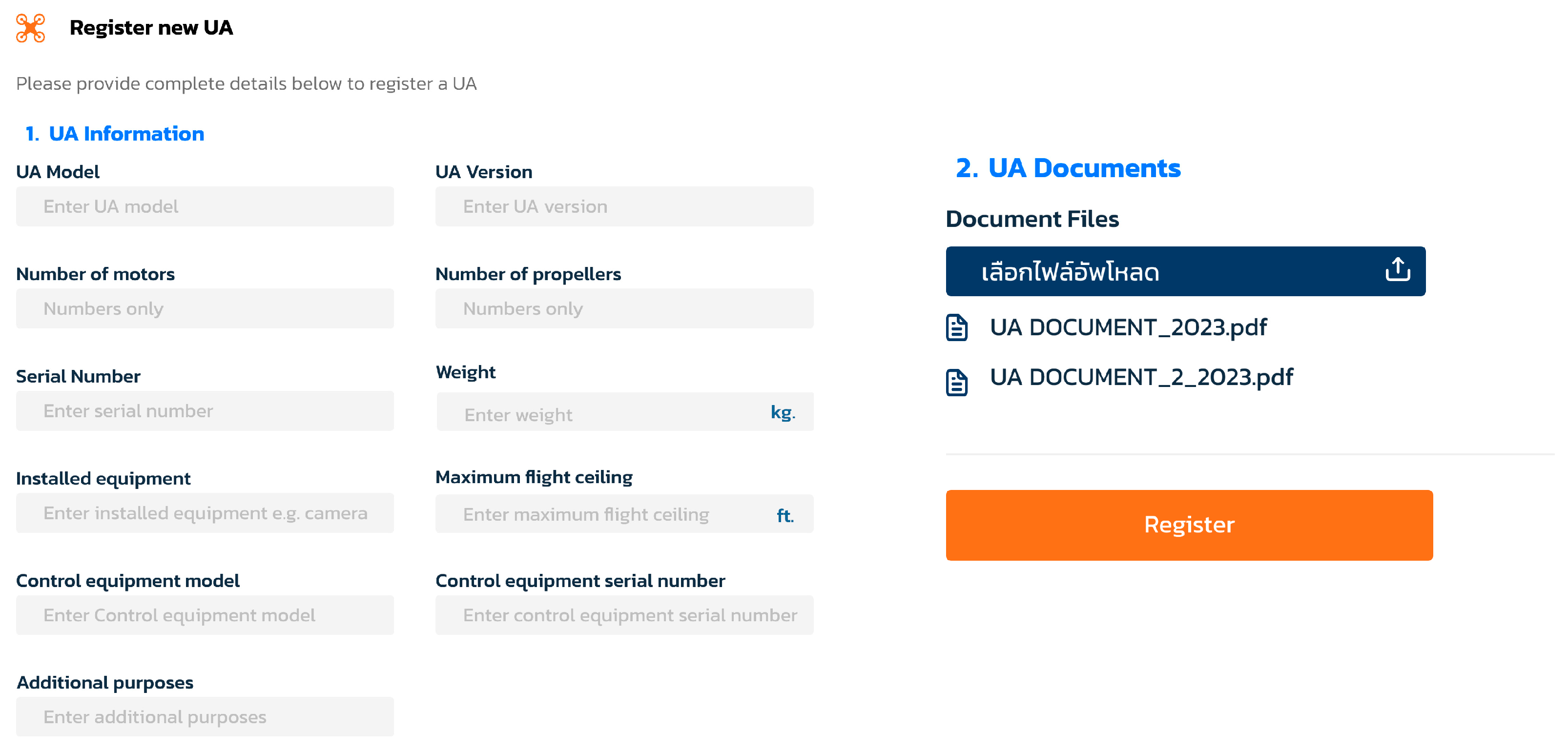
Section B of Figure 4, which pertains to UA operations, was converted into a digital format as shown in Figure 6 and Figure 7. Figure 6 primarily focuses on UA specifications and equipment while Figure 7 covers flight location, time, and route information.
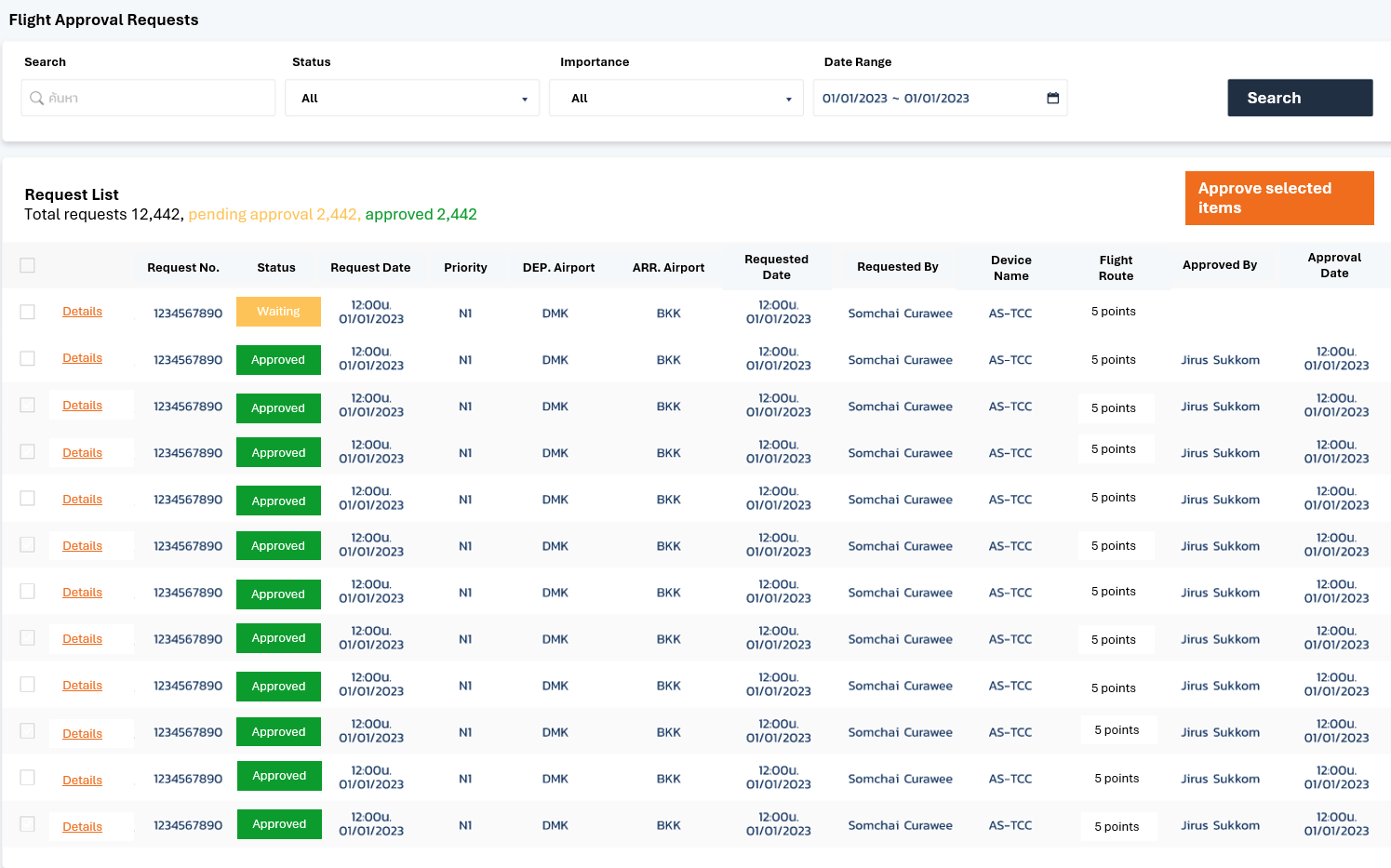
Lastly, Figure 8 presents the dashboard designed for UAS authorities to view information related to all UA registered through the website. This enables authorities to oversee operations effectively and supports the centralization of the flight planning system.

3.7. Website Testing and Validation

To validate the functionally, system-level evaluation and pilot tests were conducted to assess its functionality, reliability, and user experience. Over 300 simulated flight plan submissions were processed in test environments, spanning various scenarios such as urban proximity, BVLOS conditions, and restricted zones. User Acceptance Testing (UAT) with 20 UA operators and 5 regulatory officers revealed positive feedback. Key highlights included the following:
95% satisfaction with the user interface;
90% agreement that the system reduced paperwork;
92% reported better tracking and clarity of flight plan status.
API testing was conducted using Swagger and postman for API validation, response time under load, authentication logic, and service reliability. Additionally, interservice communication was evaluated under simulated user requests including flight plan submission and approval routing. The system demonstrated stable API performance with average response times under 100 milliseconds per request. The built-in risk assessment module correctly identified high-risk zones and recommended manual review with an accuracy of 96%, as validated by domain experts. The approval workflow accurately tracked and logged multi-role decisions, and audit trails were successfully captured. The system’s modular design allowed individual services to be independently deployed and scaled. System logs showed zero service interruptions over 72 h of continuous testing. The system test results are shown in Table 6.

4. Discussion

Through the use of SEM analysis, it was concluded that suitable area and safety assurance significantly mediate the effectiveness of the mission planning system, which is consistent with the existing literature [1,6]. This finding underscores the importance of integrating geospatial and regulatory constraints into operational planning. The UAS Standard emerged as a key construct, highlighting the necessity of incorporating airworthiness requirements, operational restrictions, and certification frameworks [5,9]. Furthermore, UAS standards not only enhance mission safety but also promote harmonization with global UTM systems, such as those developed by NASA [20], SESAR [21], and ICAO [2].
Additionally, a strong correlation was found between mission processes and safety, indicating that mission planning tools must include core functionalities such as procedural protocols, emergency handling mechanisms, and airspace coordination [5,7]. The GoFly platform was designed following human-centered design principles, particularly emphasizing interface simplicity, user feedback, and alignment with ISO 9241-210 standards [22]. This approach is essential to ensure that a wide range of UA operators from recreational users to commercial pilots can intuitively use the system while maintaining compliance with local regulations.
However, several limitations were identified that warrant further investigation:
  • Field validation was limited to specific geographic areas within Thailand, which may not capture broader terrain and regulatory diversity. Future work should include expanded field trials across various environments such as urban, coastal, and forested zones to improve the platform’s generalizability and robustness.
  • The user evaluation process primarily relied on self-report questionnaires and observational data. Future iterations should incorporate longitudinal user studies and controlled simulations to assess cognitive load, task performance, and situational awareness under varying mission scenarios.
  • The current prototype does not yet incorporate machine learning (ML) or artificial intelligence (AI) for route optimization, obstacle avoidance, or battery management. Future research should explore integrating predictive routing, real-time risk assessment, and adaptive behavior models to enhance platform intelligence and autonomy.

5. Conclusions

To conclude, with the increasing usage of UA worldwide, especially in the operations of low altitude, the global aviation community is making the submission of flight plans a mandatory procedure. However, flight plan procedures and regulations in Thailand are still underdeveloped as these systems are manual and decentralized. As a result, this study utilized SEM to analyze the important factors associated with UAS operations so that a new flight plan format can be developed. This study also affirms that regulatory frameworks are fundamental to shape safe and effective UAS flight planning, especially in the context of low altitude operations. By applying SEM, the four latent constructs STD, SUI, MIS, and SAF were validated as significant predictors of planning quality. The statistical validity of the SEM, supported by multiple goodness-of-fit indices, reinforces its utility for guiding regulatory design.
The proposed flight plan prototype, grounded in ICAO guidelines and validated by SEM, was converted into the GoFly website. This helps agencies such as CAAT transition from fragmented, manual processes toward integrated, digital flight planning ecosystems. This platform supports structured flight plan submission, approval workflows, and aircraft registration, thereby addressing Thailand’s existing regulatory and operational gaps.
The platform modular architecture and dynamic inputs allow it to accommodate different risk categories and operational needs, improving both usability and regulatory oversight. With integration-ready design elements, the prototype facilitates smooth interoperability with regulatory databases, zone-based restrictions, and authentication protocols, ensuring it can serve as a national or regional standard. GoFly can evolve to incorporate emerging technologies such as national digital identification systems, real-time surveillance feeds, and secure communication layers. These integrations will further enhance the platform’s alignment with future smart aviation infrastructures.

Author Contributions

S.Y. (Siriporn Yenpiem), S.Y. (Soemsak Yooyen), and A.T.: conceptualization, methodology, and software; S.B.: support in the preparation of this article; K.R.Y.: writing the original draft, review and editing. All authors have read and agreed to the published version of the manuscript.

Funding

This research was funded by the International Academy of Aviation Industry, King Mongkut’s Institute of Technology Ladkrabang, grant number 2566-02-18-003.

Data Availability Statement

The data presented in this study are available on request from the corresponding author.

Acknowledgments

The authors would like to thank Krai-Rergs Chatamra for his constructive comments and Chieng Pawchit for his support of the mathematical modeling used in this research. Additionally, we appreciate all the participants for their time and contribution to the interviews.

Conflicts of Interest

The authors declare no conflicts of interest.

Abbreviations

The following abbreviations are used in this manuscript:
AGFIAdjusted Goodness-of Fit Index
ANSPAir Navigation Service Providers
ATCAir Traffic Controller
ATSAir Traffic Services
BVLOSBeyond Visual Line of Sight
CAATCivil Aviation Authority of Thailand
CFIComparative Fit Index
EASAEuropean Union Aviation Safety Agency
FAAFederal Aviation Administration
ICAOInternational Civil Aviation Organization
LISRELLinear Structural Relation
NOTAMNotice to Airmen
RMRRoot Mean Square Residual
RMSEARoot Mean Square Error of Approximation
SEMStructural Equation Model
SRMRStandardized Root Mean Square Residual
UAUnmanned Aircraft
UASUnmanned Aircraft System
USPUnmanned Aircraft Service Providers
UTMUnmanned Aircraft Traffic Management
VLOSVisual Line of Sight

References

  1. Union Aviation Safety Agency (EASA). UAS Safety Risk Portfolio: A Preliminary Assessment of Known Safety Occurrences with Unmanned Aircraft Systems; EASA: Cologne, Germany, 2016; Available online: https://www.easa.europa.eu/sites/default/files/dfu/UAS%20Safety%20Analysis.pdf (accessed on 29 July 2025).
  2. International Civil Aviation Organization (ICAO). Unmanned Aircraft Systems Traffic Management (UTM) Framework, 4th ed.; ICAO: Montréal, QC, Canada, 2024; Available online: https://www.icao.int/safety/UA/Documents/UTM%20Framework%20Edition%204.pdf (accessed on 29 July 2025).
  3. FAA. UAS Traffic Management (UTM) Concept of Operations v2.0; FAA: Washington, DC, USA, 2022. Available online: https://www.faa.gov/sites/faa.gov/files/2022-08/UTM_ConOps_v2.pdf (accessed on 29 July 2025).
  4. Civil Aviation Authority of Thailand (CAAT). Guidance Material CAAT GM UAS 010: Procedures for Unmanned Aircraft Operations; CAAT: Bangkok, Thailand, 2024; Available online: https://uasportal.caat.or.th/guidanceFlight (accessed on 29 July 2025).
  5. International Civil Aviation Organization (ICAO). Circular 328: Unmanned Aircraft Systems (UAS); ICAO: Montréal, QC, Canada, 2011; Available online: https://www.icao.int/meetings/uas/documents/circular%20328_en.pdf (accessed on 29 July 2025).
  6. International Civil Aviation Organization (ICAO). Manual on Remotely Piloted Aircraft Systems (RPAS); Doc 10019; ICAO: Montréal, QC, Canada, 2015. [Google Scholar]
  7. ICAO UAS Panel. The Universal Framework for UAS and UTM Integration. In Proceedings of the ICAO UAS Panel Meeting, Montréal, QC, Canada, 12–14 November 2019; Available online: https://www.icao.int/safety/UA/Documents/UAS-UTM-Framework.pdf (accessed on 29 July 2025).
  8. Anonymous. Interview with UAS Pilots, Air Traffic Controllers, and Engineers; Internal Report; Transportation Commission of the Thai Senate: Bangkok, Thailand, 2024. [Google Scholar]
  9. Jöreskog, K.G.; Sörbom, D. LISREL 8: Structural Equation Modeling with the SIMPLIS Command Language; Scientific Software International: Chicago, IL, USA, 1989. [Google Scholar]
  10. Yenpiem, S.; Yooyen, S.; Banchong-Aksorn, S.; Yoneyama, K.R.; Jansri, A.; Mitrathanun, P. The Development of an Automated Technology for Unmanned Aircraft CNS/UTM in Compliance with Safety and Security Measures of the State. In Proceedings of the 2025 Integrated Communications, Navigation and Surveillance Conference (ICNS), Brussels, Belgium, 8–10 April 2025; pp. 1–10. [Google Scholar] [CrossRef]
  11. Hair, J.F.; Black, W.C.; Babin, B.J.; Anderson, R.E.; Tatham, R. Multivariate Data Analysis, 7th ed.; Pearson International Edition: Upper Saddle River, NJ, USA, 2010. [Google Scholar]
  12. Hair, J.F.; Black, W.C.; Babin, B.J.; Anderson, R.E.; Tatham, R. Multivariate Data Analysis, 6th ed.; Pearson International Edition: Upper Saddle River, NJ, USA, 2006. [Google Scholar]
  13. ICAO. Procedures for Air Navigation Services—Air Traffic Management (PANS-ATM), 16th ed.; Doc 4444; ICAO: Montréal, QC, Canada, 2016. [Google Scholar]
  14. TIBCO Software Inc. LISREL 10.30 User’s Guide; TIBCO: Palo Alto, CA, USA, 2022; Available online: https://docs.tibco.com (accessed on 29 July 2025).
  15. Byrne, A. Structural Equation Modeling with EQS and EQS/Windows; Sage Publications: Thousand Oaks, CA, USA, 1994. [Google Scholar]
  16. Hooper, D.; Coughlan, J.; Mullen, M.R. Structural Equation Modelling: Guidelines for Determining Model Fit. Electron. J. Bus. Res. Methods 2008, 6, 53–60. Available online: https://pmc.ncbi.nlm.nih.gov/articles/PMC4804052/ (accessed on 29 July 2025).
  17. Hu, L.T.; Bentler, P.M. Cutoff Criteria for Fit Indexes in Covariance Structure Analysis: Conventional Criteria versus New Alternatives. Struct. Equ. Model. 1999, 6, 1–55. [Google Scholar] [CrossRef]
  18. Kline, P. Evaluating Model Fit in Structural Equation Modeling: The χ2/df Ratio, RMSEA, CFI, and SRMR Thresholds. Psychol. Methods 2010, 15, 137–150. [Google Scholar] [CrossRef]
  19. Schermelleh-Engel, K.; Moosbrugger, H.; Müller, H. Evaluating the Fit of Structural Equation Models: Tests of Significance and Descriptive Goodness-of-Fit Measures. Methods Psychol. Res. Online 2003, 8, 23–74. [Google Scholar] [CrossRef]
  20. Kline, R.B. Principles and Practice of Structural Equation Modeling, 4th ed.; Guilford Press: New York, NY, USA, 2015. [Google Scholar]
  21. Tanaka, J.S.; Huba, G.J. A Fit Index for Covariance Structure Models under Arbitrary GLS Estimation. Br. J. Math. Stat. Psychol. 1985, 38, 197–201. [Google Scholar] [CrossRef]
  22. NASA; FAA. UTM Conflict Management Model v2.0; NASA Technical Documents: Washington, DC, USA, 2020. Available online: https://ntrs.nasa.gov/api/citations/20200002962/downloads/UTM_Conflict_Management_Model.pdf (accessed on 29 July 2025).
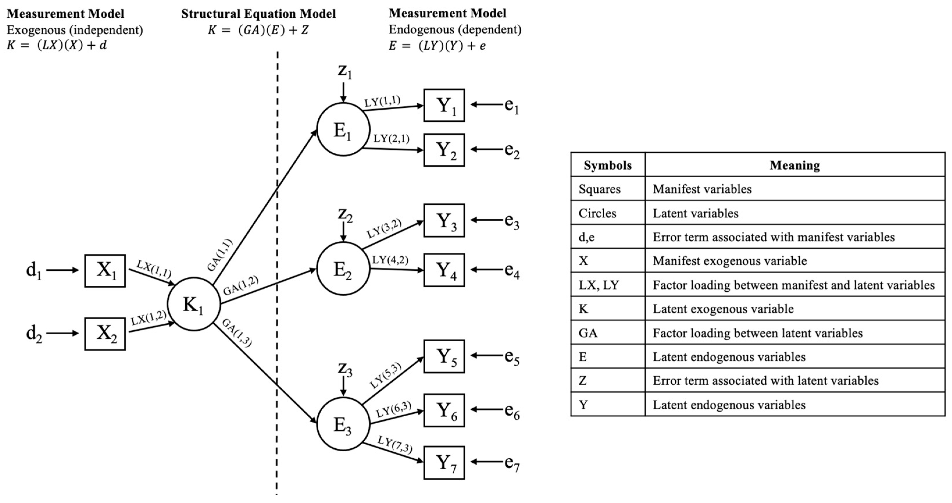
Figure 1. The SEM along with a table showing the symbols and the corresponding meanings.
Aerospace 12 00826 g001
Figure 2. Four latent variables (blue) and their corresponding measured variables (white).
Aerospace 12 00826 g002
Figure 3. SEM.
Figure 3. SEM.
Aerospace 12 00826 g003
Figure 4. Flight plan for low altitude UA operations.
Aerospace 12 00826 g004
Figure 5. GoFly website: (A) login page; (B) register as new user.
Aerospace 12 00826 g005
Figure 6. GoFly webpage asking for UA specifications and equipment.
Aerospace 12 00826 g006
Figure 7. GoFly webpage asking for flight route and operation details.
Aerospace 12 00826 g007
Figure 8. Authority dashboard for GoFly website.
Aerospace 12 00826 g008
Table 1. Characteristics of three risk levels.
Category of OperationRisk LevelCharacteristics
OpenLowUnrestricted, visually observed, low altitude, low speed, operating in open areas, and include activities such as sports or state aircraft.
SpecificMediumExtended flight duration, not visible by sight, operating in uncontrolled or overpopulated areas, and weighing less than 25 kg.
CertifiedHighOperating in dense area, high altitude, commercial service mission, flying in shared airspace with other aircraft or group flights, and weighing more than 25 kg.
Table 2. The key differences between manned aircraft and low altitude UA operations across multiple operational and regulatory dimensions.
AspectFlight Plan for Manned AircraftLow Altitude Flight Plan for UA
Flight planRequires ICAO format flight plan submission via ATS systems.Often does not require a formal flight plan. May use simplified or informal submission procedure.
Presence of pilotRequires pilot onboard for operation.No pilot onboard, operated remotely or
autonomously.
System operationCommunications, Navigation, and Surveillance (CNS)/Air Traffic Management (ATM).Internet, cellular connectivity (4G/5G), Wi-Fi, or satellite links to connect to cloud or remote servers.
Remote
Identification and tracking
Surveillance system such as radar system, Automatic Dependent Surveillance–Broadcast and Wide Area Multilateration.Remote ID, cloud-based system, and 4G/5G network.
Flight rule operationGeneral rule, Visual Flight Rule, or Instrument Flight Rule.General rule, Visual Line of Sight (VLOS), and Beyond Visual Line of Sight (BVLOS)
CrewTypically requires a crew consisting of pilots,
co-pilots, and possibly flight engineers.
No crew onboard. Controlled by operators on the ground.
TrainingRequires extensive training for pilots and crew
members.
Requires training for operators, but less extensive compared to manned aircraft pilots.
Altitude rangeUsually 3000–46,000 feet Above Mean Sea Level.Ground level to 500 feet or 200 feet Above Mean Sea Level.
Flight phase and
landing system
Performance-based Navigation, air traffic control communication protocols between pilots and air traffic controllers (ATC), VHF Omnidirectional Range, and Instrument Landing System.Ground-based or satellite communication reliance on data links (either non-traditional ground-based links, C2 Links or data links associated with UTM systems).
Weather
considerations
High-altitude weather conditions and jet streams.Micro-weather.
Flight durationLong durations with possible fuel refueling.Shorter duration, limited by battery life or capacity.
NavigationUses avionics systems such as Required Navigation Performance and Performance-based Navigation.Relies on GNSS and other sensors.
Emergency
response
Pilots can respond to emergencies in real-time and may have access to better resources.May require fail-safes for autonomous operation and contingency planning for loss of communication.
Airspace
restrictions
Subject to airspace regulations and restrictions,
including controlled airspace and restricted
areas.
May have restrictions when flying near
airports, populated areas, or areas with
infrastructures.
Mission durationLimited by crew fatigue, fuel capacity, and other
factors.
Longer durations due to reduced need for rest
periods and more efficient fuel consumption in some cases.
Flight planning
complexity
More complex flight planning due to longer distances, higher altitudes, and ATM considerations.Simplified flight planning due to lower altitudes and typically shorter flight distances.
Operational
procedures
Follows ICAO/ATC protocols, including
standard operating procedures and contingency protocols coordinated with ATC.
Requires UTM and ATM specific operational
procedures including normal, contingency, and emergency scenario, supported by automated
functions.
Air traffic serviceANSPCurrently undefined USPs.
Law and
regulations
ICAO Chicago Convention and national civil aviation regulations, with detailed provisions for pilot licensing, airworthiness, and ATM
integration.
National-level UAS-specific regulations, often outside the ICAO Annexes. Include rules for registration, remote pilot certification, VLOS/ BVLOS operations, Remote ID, and UTM
system integration.
Data recordingATC data retention and aircraft flight recorder
requirements.
Non-specific flight recording system.
Table 3. A summary of the direct and indirect influences of the studied latent variables.
VariablesCo-EfficientTypes of
Influence
LAW on STD0.19Direct
LAW on SUI0.72Direct
LAW on MIS0.55Direct
LAW on SAF0.57Direct
LAW on SUI through STD0.19 × 0.41 = 0.08Indirect
LAW on MIS through STD and SUI0.19 × 0.41 × 0.26 = 0.02Indirect
LAW on SAF through STD, SUI, and MIS0.19 × 0.41 × 0.26 × 0.25 = 0.01Indirect
LAW on MIS through STD0.19 × 0.48 = 0.09Indirect
LAW on SAF through STD0.19 × 0.42 = 0.08Indirect
Table 4. Calculated model fit indices.
Name of
Category
Index NameLevel of
Acceptance
ValueResultsModel Interpretation
Parsimonious fitχ2/df<21.082Qualified [13,14,15]Good fit.
Absolute
fit
p-value>0.050.229Qualified [13,14]Consistent.
GFI>0.950.97Qualified [16]Harmonious.
RMSEA<0.080.015Qualified [17]Consistent with empirical data.
RMR≤0.050.012Qualified [17]Has squared average of remainder.
SRMR≤0.050.04Qualified [17]Consistent.
Incremental
fit
CFI>0.950.98Qualified [18,19]Consistent with empirical data.
AGFI>0.950.97Qualified [18,19]Harmonious when adjusted.
Table 5. Comparison of other types of global UTM architectures with GoFly.
FeaturesNASA TCLSESAR
U-Space
FAA
Federated
ICAO OSAMGoFly
Open-source availability
Local policy adaptation
Thai language interface
Risk-based auto-approval
Modular microservices
Integrated CFA/SEM
Table 6. System test results summary.
MetricThresholdResultsStatus
API latency<100 ms87 ms
Risk module accuracy>90%96%
Uptime (72 h)>99%100%
Disclaimer/Publisher’s Note: The statements, opinions and data contained in all publications are solely those of the individual author(s) and contributor(s) and not of MDPI and/or the editor(s). MDPI and/or the editor(s) disclaim responsibility for any injury to people or property resulting from any ideas, methods, instructions or products referred to in the content.