Article

Effects of Sea Level Rise on Hydrodynamics and Spatial Variation in Mexican Coastal Wetlands Along the Pacific Americas Flyway

by
Román Alejandro Canul Turriza
1,*,
Violeta Z. Fernández-Díaz
2,*,
Roselia Turriza Mena
1,
Karla Gabriela Mejía-Piña
2 and
Oscar May Tzuc
1
1
Facultad de Ingeniería, Universidad Autónoma de Campeche, Campus V, Predio s/n por Av. Humberto Lanz Cárdenas y Unidad Habitacional Ecológica Ambiental Siglo XXIII, Ex–Hacienda Kalá, Campeche 24085, Mexico
2
Facultad de Ciencias Marinas, Universidad Autónoma de Baja California, Carretera Tijuana-Ensenada 3917, Fraccionamiento Playitas, Ensenada 22860, Mexico
*
Authors to whom correspondence should be addressed.
Climate 2025, 13(6), 120; https://doi.org/10.3390/cli13060120
Submission received: 8 October 2024 / Revised: 14 December 2024 / Accepted: 16 December 2024 / Published: 6 June 2025
(This article belongs to the Special Issue Coastal Hazards under Climate Change)

Abstract

:
Globally, coastal wetlands are among the most dynamic and important environments due to their wide range of environmental services, from which coastal communities benefit. Mexico has coastal wetlands that are a priority in the Pacific Flyway in America, since every year millions of shorebirds use these wetlands to reproduce and rest during their migration, in addition to various species that live there and are under some protection standard or in danger of extinction. In addition, these Mexican wetlands are also spaces from which important growing coastal communities benefit. However, the conservation of these coastal sites will be compromised in the coming decades by sea level rise and increasing pressure derived from coastal development, which directly impact the potential loss of space and consequently the decrease in migratory bird populations. This work identifies hydrodynamic changes and the effects of sea level rise in five coastal wetlands in Mexico and the Pacific Flyway in America, focusing on the future availability of space and the potential loss of ecosystem services under projected scenarios. The results generated give us a knowledge base to design strategies focused on the conservation and resilience of these wetlands in the face of sea level rise.

1. Introduction

Global mean sea level rise (SLR) as a result of global climate change is virtually a certainty [1]. Historical records and climate model projections presented in the IPCC’s Sixth Assessment Report (AR6) established that, in recent decades, sea levels have risen rapidly and will continue to rise in a range of 0.3–1.2 m by 2100 [1,2,3], with coastal flooding being one of the main threats to low-lying coastal areas, coastal ecosystems, and coastal communities [4,5,6].
Wetlands, as highly productive coastal ecosystems, are home to a great diversity of species, as they provide essential services for the survival of flora and fauna (habitat, shelter, food, etc.) and offer a wide range of environmental and economic benefits for coastal societies (water purification, fisheries, coastal protection, recreational activities, ecotourism, etc.). [7,8,9,10,11]. Wetlands are particularly sensitive to the effects of SLR, ocean–continent hydrodynamic interactions, and human activities [7,8]. These effects can be reflected by changes in water level and quality, sediment distribution and accumulation, changes in salinity, changes in current speed, and wave propagation in nearby areas and the wetlands themselves [12,13,14,15]. All of these factors can cause changes in wetland dynamics and in the availability of space that is currently used by species such as migratory shorebirds, which have specific habitat needs and depend on the intertidal zone, which is expected to be reduced due to future flooding [16].
The Pacific Americas Flyway (PAF) is comprised of an extensive network of coastal sites across 14 countries and multiple biomes and ecosystems. Each year, the PAF is used by millions of shorebirds to breed and rest during their migration from the Arctic to South America [17]. On their way through Mexico, they use the Pacific wetlands to feed, spend non-reproductive periods, rest, and spend the winter, sharing space with resident birds. Anthropogenic pressures on coasts and changing climatic conditions have negatively impacted migratory shorebird populations. While there are numerous threats to PAF shorebirds, SLR has been determined to be a high-level threat based on the Open Conservation Standards for the Practice of Conservation (CS) because of the strong impact it can have on habitat availability and quality throughout the Western Hemisphere [17,18,19,20,21].
The importance of conserving shorebirds lies in the fact that they are a visible component of fully functional ecosystems, which can positively affect human health. In addition, they are sentinels of the environmental changes that occur and affect humans, without minimizing the great cultural, historical, and environmental importance they possess [17]. In this sense, a basic conservation strategy is the preservation of the coastal spaces that are used. Studies on wetland restoration and “stepping stones” for migratory birds have been carried out in different areas of Asia, analyzing restoration efforts in the Yangtze River Delta, China, and highlighting the importance of restored wetlands as “stepping stones” [22,23,24,25,26,27]; in South America, examining the restoration of wetlands and their role as a habitat for migratory birds and emphasizing how restoration benefits migratory birds [28,29]; and in the Mediterranean region, such as those addressing Venice lagoon’s restoration actions [30].
Various studies have addressed the study of the multiple impacts of climate change and the SLR on global coastal spaces and the consequences on shorebird populations [17,18,19,20,21,31,32,33,34,35,36,37,38,39,40]. In Mexico, the range of existing works is wide and varied, mainly focused on establishing strategies that promote the development of programs and projects in the country for the conservation and management of shorebirds and the wetland habitat on which they depend, shorebird recovery projects, regionalized conservation projects and binational cooperation, status assessments and action plans for the conservation of specific species, and the effects of the SLR on the spatial distribution of wetlands with an applied regional approach [16,41,42,43,44,45,46], to mention a few.
In this context, this paper presents the results of an analysis of the effects on hydrodynamics and spatial availability in five Mexican coastal wetlands that are priorities for the distribution of shorebirds and that are part of the PAF. In addition, they are Ramsar sites and form the operational regionalization for shorebirds in the northwest region of Mexico [10,32]. The analysis is based on the numerical simulation of hydrodynamic scenarios projected for the end of the century, and the identification of the flood sheets resulting from the SLR in each of the wetlands considered. The results of this work provide a “big picture” of the changes in hydrodynamics in these wetlands and the effects of SLR on habitat availability for the shorebirds that use them.

2. Materials and Methods
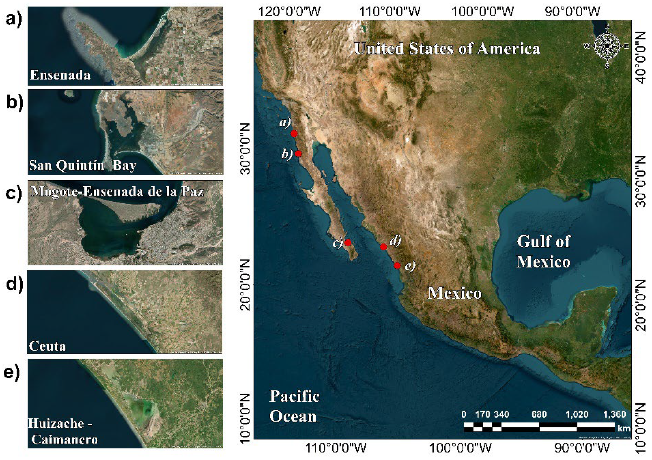
2.1. Study Area

The wetlands analyzed in this study are as follows: (a) Punta Banda estuary and (b) San Quintín, both located in Baja California; (c) Mogote—Ensenada La Paz, located in Baja California Sur; (d) Ceuta lagoon system, and (e) Huizache-Caimanero lagoon system, both located in Sinaloa (Figure 1). All of them, in addition to being important wetlands of the PAF [17], provide essential habitats for a diversity of wildlife species and are positively valued by local and regional coastal communities that carry out a wide variety of activities that depend directly on them, such as fishing, bird watching, ecotourism, recreational and cultural activities, agriculture, and aquaculture, among others. Below is a brief description of each of the sites analyzed.
(a)
Punta Banda estuary (Ramsar Site number 1604): Located 13 km south of the urban area of Ensenada, it presents a variety of intertidal marshes, mudflats, and seagrass meadows protected by a sandy bar that separates the body of water from the ocean. The Punta Banda estuary is a priority site for conservation at the state and national level due to its high presence of endemic species, its specific species richness, and its great functional importance as a center of origin and natural diversification. It is also a Site of Regional Importance in the Western Hemisphere Shorebirds Reserve Network (WHSRN) and a Mexican Important Bird Area (IBA, or AICA in Spanish No. 103) category 5, that is, an area where ornithological research work is relevant for bird conservation at a global level [47].
(b)
San Quintín Bay (Ramsar Site number 1775): It is located 180 km south of the city of Ensenada and is the largest and most important coastal wetland in Baja California. It consists of a coastal lagoon and a coastal plain, with marshes and seagrass beds that constitute one of the most important wintering sites (refuge and feeding sites) for a high population of migratory birds, among which the black branta (Branta bernicla nigricans) stands out. Due to its characteristics, this wetland is considered rare or uncommon for the Californian biogeographic region, in addition to being home to populations of various species of threatened and endangered birds and being the only place in Baja California where black chicks (Laterallus jamaicensis), a relevant and endangered species, have been sighted. San Quintín Bay is a WHSRN Site of Regional Importance and AICA No. 102 [48].
(c)
Mogote—Ensenada La Paz (Ramsar Site number 1816): It is a coastal lagoon separated from the La Paz Bay by a sand barrier (El Mogote). The mangroves of Ensenada La Paz have floodplains and internal water bodies, creating small lagoons that are important nesting, breeding, and rest areas for many bird species, with most of them under special legal protection. In total, 37% of the bird species are migratory, and on their journey south, they stop in to eat and rest during the winter season. Ensenada La Paz is recognized by at least three more distinctions: 1) a WHSRN Site of Regional Importance; 2) Priority Wetland for Shorebirds in Mexico (No. 20); and 3) AICA No. 93 category G-1 (Global) [49].
(d)
Ceuta coastal system lagoon (Ramsar Site number 1824): This system is formed by several lagoon complexes and marshes and has an important extension of mangrove vegetation. Due to its characteristics, diversity, and abundance of bird species, it is considered a WHSRN Site of Regional Importance and AICA No. 247. This system supports huge populations of shorebirds, such as Calidris mauri, Phalaropus tricolor, Recurvirostra americana, Charadrius alexandrinus, and Sterna maxima, where the intertidal influence plays a fundamental role in the conservation of migratory shorebirds. The site is also found under the sanctuary category at a national level [50].
(e)
Huizache—Caimanero coastal lagoon (Ramsar Site number 1689): located in the southeastern part of the Gulf of California, the site consists of a series of wetlands, ranging from coastal and continental to artificial. Due to its location along the PAF, it is a site of high importance for migratory birds in Mexico, including the American White Pelican (Pelecanus erythrorhynchus) and the Roseate Spoonbill (Ajaia ajaia). It is a WHSRN Site of Regional Importance and AICA No. 147. The riverside of the lagoon mainly constitutes mangrove forests (red, black, and white mangroves). According to the IUCN Protected Area Categories, the site belongs to Category IV and is under the federal jurisdiction of the National Water Commission of Mexico [51].

2.2. Topobathymetric Survey

To represent the topographic and bathymetric terrain conditions of the different coastal wetlands, a topobathymetric model was generated from the union of LiDAR data with a horizontal resolution of 5 m obtained from official databases of the National Institute of Statistics and Geography (INEGI) of Mexico and digitized data from nautical charts obtained from the Secretariat of the Navy (SEMAR) and the world C-Map database. The union of the topographic and bathymetric data was carried out using geoprocessing tools (Figure 2).

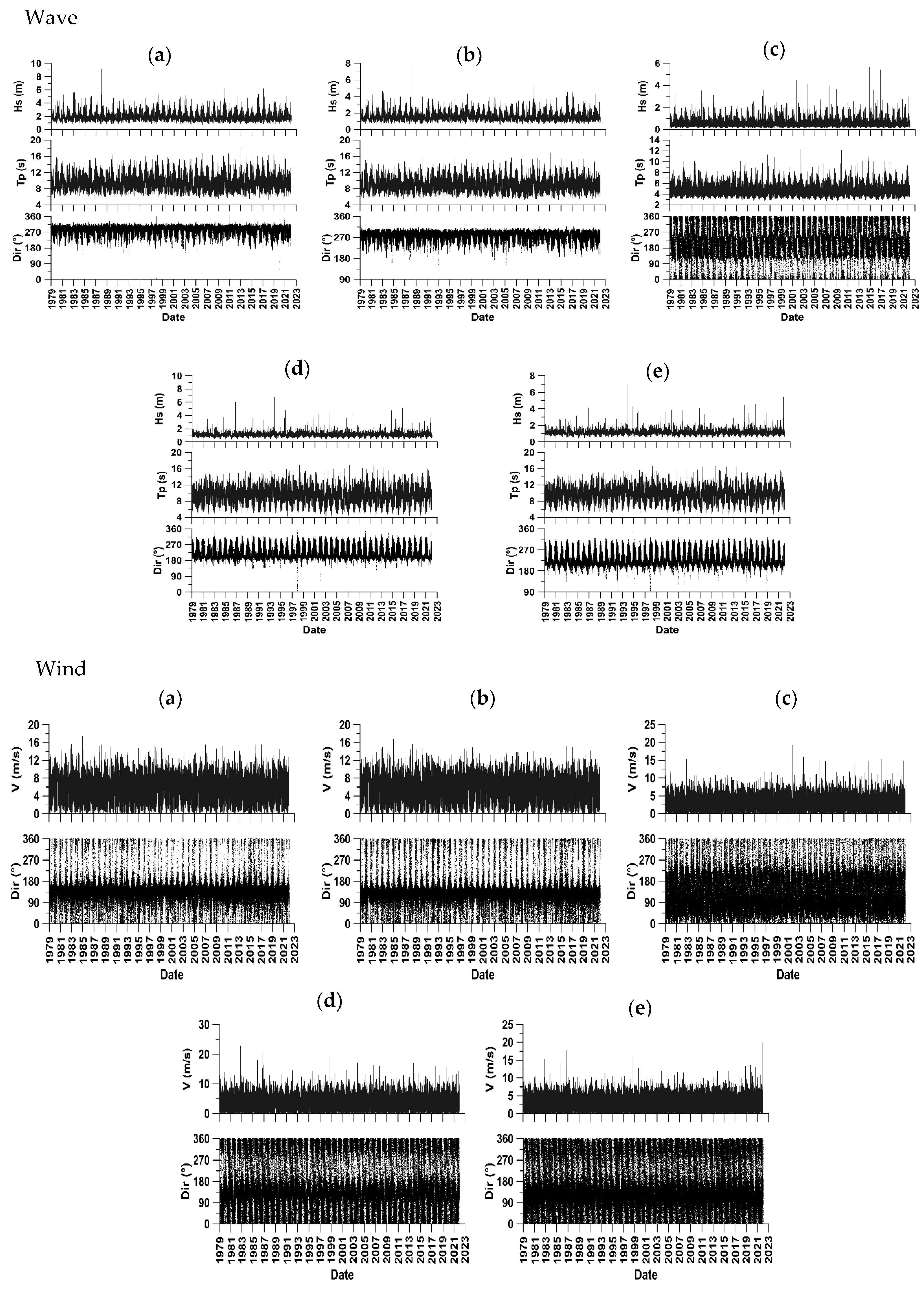
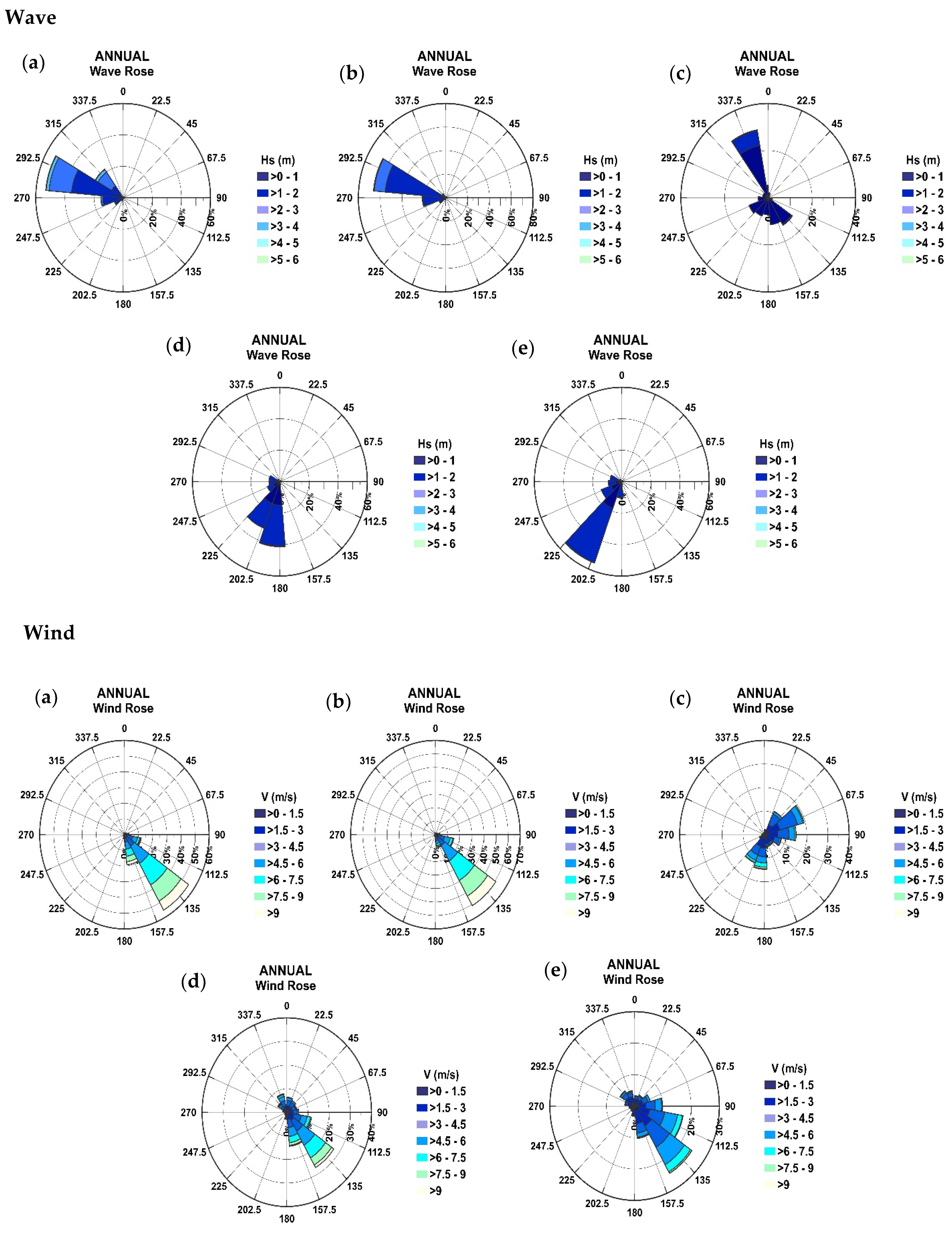
2.3. Wave and Wind Conditions

A characterization of the prevailing wave and wind conditions in each of the wetlands and surrounding areas was carried out, based on the historical and robust time series for the period between January 1979 and December 2022 obtained from the ECMWF v5 (ERA5) reanalysis model. For each site analyzed, data series were extracted from the main wave parameters (significant height, Hs12; peak period, Tp; and direction of incidence, Dir) and wind speed and direction (Figure 3).
The characterization of the waves and wind was carried out using CAROL software, developed by the Institute of Environmental Hydraulics of the University of Cantabria (IH-Cantabria), which uses statistical methods to obtain the probability of occurrence of significant wave height (SWH12) in the medium regime, direction of wave incidence (Dir) and peak periods (Tp), as well as other statistical parameters. Figure 4 shows the Dir and SWH12 of the waves and the prevailing energy speed and direction in the medium regime for each study site. Table 1 summarizes the scenarios that considered the hydrodynamic energy conditions that predominate in each of the study sites.

2.4. Sea Level Rise Projection and Tidal Levels

To establish the projected sea level rise for 2100, NASA’s Sea Level Projection Tool was used [52], which allows one to visualize and download sea level projection data based on the latest IPCC Assessment Report (AR6). The total sea level for scenario SSP5-8.5 and Horizon 2100 was taken as a basis. Based on this tool, the SLR values for the Punta Banda estuary and San Quintín Bay region were 0.69 m, while for the remaining three study sites, they were 0.82 m.
Tidal conditions were obtained from data records from the global tide model developed by DTU Space (DTU10) [53], representing the main diurnal currents (K1, O1, P1 Y Q1) and the semidiurnal tidal components (M2, S2, N2 Y K2) with a spatial distribution of 0.125° × 0.125° based on TOPEX/POSEIDON altimetry data (data applied at 20 m depth). The admiralty method was used, which explicitly considers the four main components M2, S2, O1, and K1, and allows corrective factors to consider the effects of several astronomical components generated in shallow waters.
The values of sea level rise and tidal conditions were added to the values presented in Table 1 to generate the sea level rise scenarios at each study site.

2.5. Model Setup

Mike 21, the model developed by DHI Water and Environment to run the two-dimensional (2D) simulation of hydrodynamics, waves, sediment dynamics, water quality, and ecology [54], was used in this study. This model has been widely used in various works focused on evaluating water levels and flow in coastal areas [55,56,57,58,59].
A computational domain was generated for each coastal wetland and adjacent coastal zone to simulate hydrodynamics (Figure 5). For each domain, an unstructured triangular 2D mesh was used, which varied in all nodes and cell size between mesh and mesh according to the simulation needs at each site. The 2D spectral wind–wave modeling (SW) module was used to describe the near-shore wave field considering the transformations associated with depth, coupling the results to the hydrodynamic module Mike 21 (HD) to simulate sea surface elevation and coastal currents in the study areas under projected SLR conditions. The numerically simulated hydrodynamic scenarios in this work considered the characterization of the waves and wind, the projected sea level rise, and the tidal conditions in each of the wetlands. For the areas of Estero Punta Banda, the lagoon of the coastal system of Ceuta, and coastal lagoon Huizache—Caimanero, the mesh had 3 open borders, while for the areas of Bahía San Quintín and Mogote—Ensenada de la Paz, there was a circular border. Three simulations were carried out for each area, with a time step of 30 s for a duration of 3 effective days per model.

3. Results

3.1. Effects of Sea Level Rise on Wetlands’ Coastal Currents Field

Under the hydrodynamic scenario that considers SLR were the field and speed of the current increase in the Punta Banda estuary. At the entrance to the wetland, velocities that varied between 0.20 and 0.40 m/s are observed within the body of water near the mouth (Figure 6a), compared to the hydrodynamic energy conditions that consider the sea level rise where velocities reach up to 0.70 m/s and a displacement of the current field inwards with velocities of up to 0.40 m/s were observed (Figure 6b), signifying an increase of approximately 75% in current speed.
In San Quintín, current velocities were similar in energetic conditions and in the SLR scenario, presenting values of up to 1.30 m/s in the inlet area and between 0.20 and 0.40 m/s inland, with up to 0.70 m/s in some spots (Figure 6c,d). The current field extended inward into the bay under SLR conditions with velocities without major variation.
In the case of El Mogote—Ensenada de La Paz, for the SLR scenario, an 8% increase in the velocity towards the interior of the body of water was observed, reaching values of 0.7 to 1.33 m/s compared to the current values of 0.65 to 1.30 m/s (Figure 6e,f), showing little marked variations in contrast to the hydrodynamic conditions without SLR.
In the Ceuta coastal system lagoon under the SLR scenario, velocities were reduced by 23% in the coastal area adjacent to the lagoon system, but an increase in the area of influence of the velocities of 0.20 m/s was observed. At the mouth of the lagoon system, the velocity ranged between 0.40 and 1.33 m/s. Inside, the extension of the current field through the main channel and an increase in velocity between 0.20 m/s and 0.40 m/s were observed (Figure 6g,h).
In the Huizache—Caimanero coastal lagoon, the current speed in the adjacent coastal area was reduced by approximately 70% under the SLR scenario, going from 0.70 m/s to 0.20 m/s; however, inside the lagoon system, the field of currents extended at the same speed as outside (Figure 6i,j).

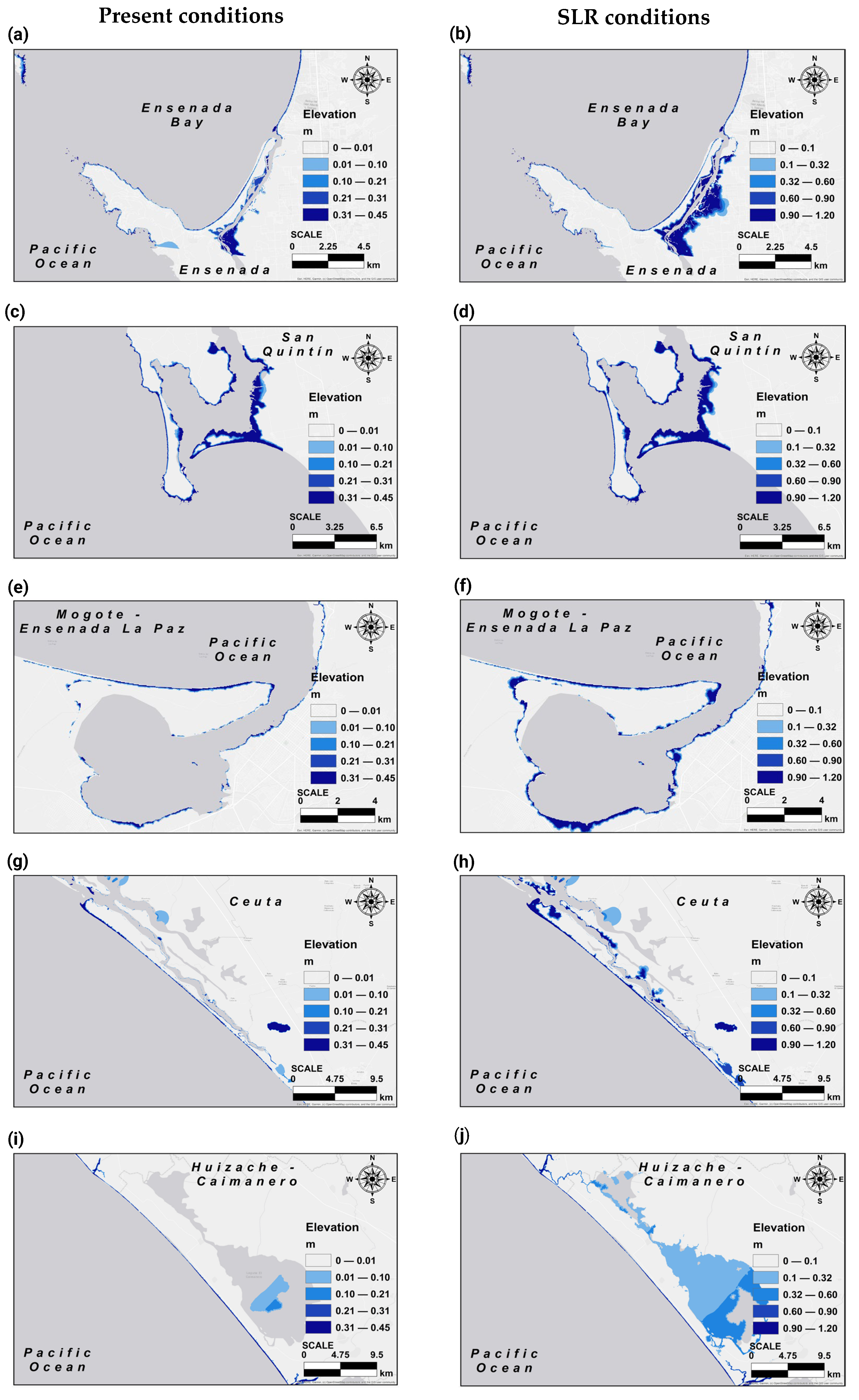
3.2. Effects of Sea Level Rise on Land Extension Flooding

In the Punta Banda estuary, under conditions without SLR, the elevation of the flood sheet was up to 0.45 m, as a result of the average hydrodynamic energy conditions that occur at the site (Figure 7a). Under the SLR scenario, the results show an increase in the extent of the floodplain inland inside the wetland and on the sand bar that separates the body of water from the sea, enhancing elevations of water sheets by up to 1.20 m (Figure 7b) inside the estuary. The quantification of the flood extent was calculated at 1668 ha of wetland that could be permanently flooded (Table 2).
For San Quintín Bay, in conditions without SLR, the maximum elevation of the flood sheet was 0.45 m, occurring more frequently in the eastern part of the bay and to the north in the internal zone (Figure 7c). Under the SLR scenario, flood sheet elevations were boosted up to 1.20 m compared to 0.45 m without SLR (Figure 7d). The extension of the floodplain was quantified at 1500 ha corresponding to the wetland, that is, space that would be permanently flooded.
In the case of El Mogote—Ensenada de La Paz, the results show SLR flood sheets of up to 1.20 m compared to the present conditions of 0.45 m elevation, which were concentrated at the entrance to the body of water and in the southern region inside the body of water, where an extension of the floodplain was observed in a large part of the wetland, quantifying an impact of 1300 ha of permanently flooded wetland (Figure 7e,f).
In the Ceuta coastal system lagoon, under current conditions, the elevations of the flood sheet were between 0.21 and 0.45 m in the surrounding coastal zone and the entrance to the lagoon system (Figure 7g). Under the SLR scenario, the extension of the floodplain increased inside the lagoon complex, reaching areas where the water level does not currently reach. The elevation in the flood sheet also increased with values of up to 1.20 m focused on the entrance mouth of the lagoon system and on some sites inside the lagoons (Figure 7h). For Ceuta, a permanent flood extension was quantified in 700 ha of wetlands.
In the Huizache—Caimanero coastal lagoon, the main changes occurred in the north and south mouths that connect the lagoon to the sea, presenting an increase in the elevation of the flood sheet from 0.45 m to 1.20 m, and inside the lagoon with elevations ranging from 0.10 m to 0.60 m (Figure 7i,j). In turn, a wide extension of the floodplain was observed towards the interior of the body of water, quantifying, for this study site, a total of 800 ha of potential wetlands to be permanently flooded due to sea level rise.

4. Discussion

The results of this work show that sea level rise modifies the field and speed of the currents, the elevations of the flood sheet, and extends the floodplains in the vicinity and within the analyzed wetlands. Generally, the speed of the current increases at the mouth that connects with the sea and towards the interior of the lagoon bodies and decreases on the exposed coast adjacent to the bodies of water (Figure 6), as observed in the Huizache—Caimanero coastal lagoon (Figure 6i,j). The decrease in velocities outside the lagoons may be due to a decrease in dissipation during the breaking of the waves and a larger water column that in turn allows a smaller wave area to develop [2,13,59]. On the other hand, the increase in the speed of the current in the lagoon bodies increases as a function of the SLR, together with the bathymetric and coastal conditions [7]. Increasing the speed of the current in the analyzed wetlands can have a significant impact in terms of water circulation, sediment removal, dispersion of pollutants, increased tidal prism and saline intrusion, and flooding in the lowlands, as has been shown in other studies [2,14].
In addition to modifying the speed of the current, SLR increases the elevation of the water sheet and the risk of flooding in the lowlands [7]. In all the Mexican wetlands analyzed in this work, an increase in the elevation of the flood sheet and the extension of the floodplains inland are observed. This represents a great impact on the future availability of spaces that are currently priority areas for birds, derived from the ecosystem services provided by these wetlands, and compromising areas of vital importance within the Pacific Flyway. In this study, we consider space as those intertidal areas that meet the specific physical conditions necessary for migratory shorebirds to feed, rest, and reproduce. These conditions are based on shallow water levels, a few centimeters deep, which allow access to the substrate where their prey is found [17,18,60,61]. Although flooded areas can be considered space, not all of them are functional as a habitat for birds, since, if the water level exceeds certain depths, access to the substrate becomes very limited or almost impossible, thus decreasing the quality of the available habitat [62]. On the other hand, permanent flooding can alter sedimentary dynamics and the distribution of resources, indirectly affecting the suitability of these spaces for shorebirds. Therefore, the increase in flooded areas does not translate into a greater availability of usable space, but rather may represent a loss of functional habitats for shorebirds [5,16]. Although the process of erosion by SLR was not simulated or quantified in this study, it is considered that it will be present in most of the wetlands and surrounding coasts, since the increase in water depth modifies the surf zone and allows the waves and current to accelerate the erosion process inside the land.
In this sense, it is likely that all the wetlands analyzed will have significant adverse effects due to the rise in sea level associated with the potential increase in current speed and the extension of the floodplain. In the Punta Banda estuary, at the mouth and inside the wetland, erosion and flooding are the greatest natural concerns regarding the availability of space. Currently, the sandy bar near the mouth of the estuary is a nesting site for the little tern (Sternulla antillarium), a migratory shorebird that is an important environmental indicator and is under special protection in Mexico [47]. The interior of the wetland is used by large populations of migratory and resident birds for feeding and resting, with the extension of the floodplain being a danger to habitat availability and foraging time.
In San Quintin Bay, the potential loss of sediment and space used by birds is enhanced near the mouth of the bay and in the southern sandy bar, where the greatest flood extensions occur (Figure 7d). Adjacent to this area is the most important coastal agricultural field in the state of Baja California [63], that limits the availability of wetland space inland and contributes to residual waste from agriculture; in the wetland, it enhances degradation.
El Mogote—Ensenada de La Paz represents the last feeding point for shorebirds that migrate through the Baja California Peninsula in autumn, and the first point in spring on their return trip, since its waters have little waves, which allow fine sediment to be deposited inside the body of water and form the floodplain used by shorebirds as feeding and nesting sites [49,63]. Based on the results of this work, these feeding and nesting spaces would be compromised in the future, since the increase in current velocity and greater flood extensions would represent a greater probability of reducing the space associated with sediment removal. In addition to the SLR, certain human activities threaten and have enhanced the degradation and loss of this wetland, such as real estate development, solid waste discharges, landfills with terrigenous sediment, oil, and gasoline spills that have become a serious problem derived from the growth of urban sprawl, with the latter being the main human threat to this wetland [64].
In the Ceuta coastal system lagoon and Huizache—Caimanero coastal lagoon, the elevation in the flood sheet would cause changes in depth and repercussions for some species of birds that use shallow spaces to feed. On the other hand, fishing and aquaculture activity have played an important role in the modification and degradation of these wetlands, derived from the change in land use to build shrimp farms and spaces for livestock and agriculture, causing negative impacts on the abundance and distribution of wetland vegetation [50,51]. In the Huizache—Caimanero coastal lagoon, shrimp farming has degraded the habitat, and increased sedimentation in the lagoon.
Shrimp farming degrades the habitat in wetlands by altering the spatial structure, increasing sedimentation, dumping wastewater, reducing biodiversity, increasing the disturbance caused by shrimp farming activities, and causing a loss of intertidal habitats for feeding and resting at high tide, particularly for shorebirds during migration [65,66]. Some studies suggest that certain management practices related to shrimp farms can create roosting and foraging habitats [62,67]. However, few studies have fully assessed the impact or benefits of aquaculture, including the context in which beneficial management practices can mitigate or compensate for habitat loss due to the construction of aquaculture facilities. In the neotropical breeding and migration zones, shrimp farms are expanding along the Pacific coast, especially in northwestern Mexico and Central America, in areas once occupied by mangroves and saline swamps [68,69], posing a significant threat.
As they have different morphological and hydrodynamic characteristics, each of the wetlands analyzed will have different positive and negative impacts associated with sea level rise and the anthropogenic activities that influence them. While sea level rise is imminent [70], it is of the utmost importance to propose different action measures aimed at the conservation and good use of these coastal ecosystems, among which could be mentioned the following: (a) regulate constructions, since they are also risk areas for the population due to the fragility of the soil; (b) regulate agricultural and aquaculture expansion; (c) avoid the dumping of solid and liquid waste. Wetlands are highly dynamic ecosystems that will respond to sea level rise and its effects, so it is important that buffer zones are set aside to allow these ecosystems to move and adapt.
These coastal wetlands in northwestern Mexico are of great importance within the Pacific Flyway of the Americas, as millions of migratory birds use these ecosystems as habitats to breed, rest, refuel, and winter. In this sense, the results presented here allow us to have information on the identification of flood areas to determine what measures to take to manage the inevitable floods derived from sea level rise.
The results not only have local implications for coastal wetlands in Mexico, but also provide significant insight into the effects of SLR on coastal wetlands globally. The numerical models used and the scenario projections are tools that can be replicated in coastal systems with similar characteristics. For example, recent studies have applied comparable approaches in lagoon systems in the Gulf of Mexico and Southeast Asia, revealing consistent patterns of habitat loss and the increased vulnerability of ecosystems to flooding [7,14,16]. The analysis of currents and the extent of flooded areas allows us to understand how hydrodynamic changes can affect ecosystem services. This type of study is relevant in areas of high biodiversity, but with high anthropogenic pressure, where coastal management decisions must include and prioritize conservation and the sustainable use of resources [2,4,10,18].
The approach developed here reinforces habitat assessment studies under climate change scenarios, especially in deltas, estuaries, and coastal lagoons. For example, the authors of [7] highlighted the importance of including hydrodynamic analyses to understand the responses to extreme events and SLR in Asia. Although the approach applied here can help standardize management strategies in vulnerable regions of Latin America, Africa, and Asia, more research is necessary to analyze in detail the impacts of sea level rise in these places’ coastal areas, given the detrimental consequences for estuarine ecosystems, society, and the economy. Future studies should include ground movement, including phenomena such as subsidence, active tectonics, and sedimentary contributions, since they play a fundamental role in the dynamics of coastal systems. These processes can amplify or mitigate the effects of SLR and should therefore be considered in assessing changes to wetlands and their ability to provide essential ecosystem services. For example, subsidence induced by anthropogenic actions, such as groundwater extraction, can accelerate the loss of functional habitats, even exceeding projected SLR rates [71,72].
More research is needed to further analyze the impacts of sea level rise in coastal areas, given the detrimental consequences for estuarine ecosystems, society, and the economy. Future studies should integrate models that combine SLR scenarios with storms with different return periods, land use and vegetation characterizations, the implementation of buffer zones, and the restoration of coastal vegetation. On the other hand, more robust and detailed studies can be carried out, such as the calculation of the Habitat Suitability Index (HSI), that include biological and ecological variables together with ecological models that integrate hydrodynamic results with interdisciplinary approaches to propose more specific conservation strategies adapted to the needs of key species. Coastal planning and development studies that aim to improve coastal resilience to SLR must consider the multiple effects of hydrodynamic changes on the vulnerability of coastal wetlands.

5. Conclusions

Research on the effects of sea level rise on Mexico’s coastal wetlands highlights the urgency of addressing this issue within the context of climate change. The results show that the SLR not only increases the speed of currents and the elevation of flood sheets, but also puts at risk the availability of critical habitats for migratory shorebirds that depend on these ecosystems. The extent of flooded areas and the risk of erosion threaten both biodiversity and the essential ecosystem services that these wetlands provide to coastal communities.
It is critical to implement science-based conservation strategies, including the predictive simulation of climate scenarios, coastal spatial planning, coastal development regulation, sustainable management of agriculture and aquaculture, as well as pollution reduction, and continuous assessment and monitoring. In addition, it is vital to establish buffer zones that facilitate the adaptation of these ecosystems to the changes caused by SLR. Future research should focus on a deeper analysis of the impacts of climate change on these environments, with a focus on the resilience of wetlands and the health of migratory bird populations. Only through a comprehensive and collaborative approach can the impact of SLR be mitigated and ensure the conservation of these valuable ecosystems for future generations.

Author Contributions

Conceptualization, R.A.C.T. and V.Z.F.-D.; methodology, R.A.C.T. and V.Z.F.-D.; software, R.A.C.T.; validation, R.A.C.T., V.Z.F.-D. and K.G.M.-P.; investigation, R.A.C.T., V.Z.F.-D., K.G.M.-P. and O.M.T.; resources, R.A.C.T.; data curation, R.A.C.T., V.Z.F.-D. and R.T.M.; writing—original draft preparation, R.A.C.T.; writing—review and editing, R.A.C.T., V.Z.F.-D., R.T.M. and O.M.T.; visualization, R.A.C.T., V.Z.F.-D., R.T.M., K.G.M.-P. and O.M.T.; supervision, R.A.C.T. All authors have read and agreed to the published version of the manuscript.

Funding

This work is part of the internal project of the Autonomous University of Campeche 06/UACAM/2024, financed by its resources. The APC was funded by Autonomous University of Campeche (UACAM).

Data Availability Statement

The original contributions presented in the study are included in the article; further inquiries can be directed to the corresponding authors.

Acknowledgments

We acknowledge the Coastal Solutions Fellows Program at the Cornell Lab of Ornithology for allowing us to explore these lagoon systems and encouraging us to carry out this research.

Conflicts of Interest

The authors declare no conflicts of interest.

References

  1. Fox-Kemper, B.; Hewitt, H.T.; Xiao, C.; Aðalgeirsdóttir, G.; Drijfhout, S.S.; Edwards, T.L.; Golledge, N.R.; Hemer, M.; Kopp, R.E.; Krinner, G.; et al. Ocean, Cryosphere and Sea Level Change. In Climate Change 2021: The Physical Science Basis. Contribution of Working Group I to the Sixth Assessment Report of the Intergovernmental Panel on Climate Change; Masson-Delmotte, V., Zhai, P., Pirani, A., Connors, S.L., Péan, C., Berger, S., Caud, N., Chen, Y., Goldfarb, L., Gomis, M.I., et al., Eds.; Cambridge University Press: Cambridge, UK; New York, NY, USA, 2021; pp. 1211–1362. [Google Scholar]
  2. Singer, M.N.; Cavalcante, G.H.; Atabay, S. Hydrodynamic Modeling of Sharjah Lagoons under Climate Changes, United Arab Emirates (UAE). Reg. Stud. Mar. Sci. 2023, 63, 102995. [Google Scholar] [CrossRef]
  3. IPCC Summary for Policymakers. In Climate Change 2023: Synthesis Report. Contribution of Working Groups I, II and III to the Sixth Assessment Report of the Intergovernmental Panel on Climate Change; Core Writing Team, Lee, H., Romero, J., Eds.; IPCC: Geneva, Switzerland, 2023; pp. 1–34. [Google Scholar]
  4. Vitousek, S.; Barnard, P.L.; Fletcher, C.H.; Frazer, N.; Erikson, L.; Storlazzi, C.D. Doubling of Coastal Flooding Frequency within Decades Due to Sea-Level Rise. Sci. Rep. 2017, 7, 1399. [Google Scholar] [CrossRef] [PubMed]
  5. Klingbeil, B.T.; Cohen, J.B.; Correll, M.D.; Field, C.R.; Hodgman, T.P.; Kovach, A.I.; Lentz, E.E.; Olsen, B.J.; Shriver, W.G.; Wiest, W.A.; et al. High Uncertainty over the Future of Tidal Marsh Birds under Current Sea-Level Rise Projections. Biodivers. Conserv. 2021, 30, 431–443. [Google Scholar] [CrossRef]
  6. Von Holle, B.; Irish, J.L.; Spivy, A.; Weishampel, J.F.; Meylan, A.; Godfrey, M.H.; Dodd, M.; Schweitzer, S.H.; Keyes, T.; Sanders, F.; et al. Effects of Future Sea Level Rise on Coastal Habitat. J. Wildl. Manag. 2019, 83, 694–704. [Google Scholar] [CrossRef]
  7. Wu, W.; Yang, Z.; Zhang, X.; Zhou, Y.; Tian, B.; Tang, Q. Integrated Modeling Analysis of Estuarine Responses to Extreme Hydrological Events and Sea-Level Rise. Estuar. Coast. Shelf Sci. 2021, 261, 107555. [Google Scholar] [CrossRef]
  8. Mills, L.; Janeiro, J.; Neves, A.A.S.; Martins, F. The Impact of Sea Level Rise in the Guadiana Estuary. J. Comput. Sci. 2020, 44, 101169. [Google Scholar] [CrossRef]
  9. Costanza, R.; d’Arge, R.; de Groot, R.; Farber, S.; Grasso, M.; Hannon, B.; Limburg, K.; Naeem, S.; O’Neill, R.V.; Paruelo, J.; et al. The Value of the World’s Ecosystem Services and Natural Capital. Nature 1997, 387, 253–260. [Google Scholar] [CrossRef]
  10. Barbier, E.B.; Hacker, S.D.; Kennedy, C.; Koch, E.W.; Stier, A.C.; Silliman, B.R. The Value of Estuarine and Coastal Ecosystem Services. Ecol. Monogr. 2011, 81, 169–193. [Google Scholar] [CrossRef]
  11. Day, J.; Ibáñez, C.; Scarton, F.; Pont, D.; Hensel, P.; Day, J.; Lane, R. Sustainability of Mediterranean Deltaic and Lagoon Wetlands with Sea-Level Rise: The Importance of River Input. Estuaries Coasts 2011, 34, 483–493. [Google Scholar] [CrossRef]
  12. Kuang, C.; Chen, W.; Gu, J.; Zhu, D.Z.; He, L.; Huang, H. Numerical Assessment of the Impacts of Potential Future Sea-Level Rise on Hydrodynamics of the Yangtze River Estuary, China. J. Coast. Res. 2014, 30, 586–597. [Google Scholar] [CrossRef]
  13. Tuan, V.M.; Thanh, N.V.; Lai, T.D. Accessing Impacts of Climate Change-Driven Sea Level Rise on Hydrodynamics and Sediment Dynamics along Ba Lang Beaches in Nha Trang Bay, Khanh Hoa, Vietnam. Water Sci. Eng. 2023, 17, 323–335. [Google Scholar] [CrossRef]
  14. Mohd Salleh, S.H.; Ahmad, A.; Wan Mohtar, W.H.M.; Lim, C.H.; Abdul Maulud, K.N. Effect of Projected Sea Level Rise on the Hydrodynamic and Suspended Sediment Concentration Profile of Tropical Estuary. Reg. Stud. Mar. Sci. 2018, 24, 225–236. [Google Scholar] [CrossRef]
  15. Neumann, B.; Vafeidis, A.T.; Zimmermann, J.; Nicholls, R.J. Future Coastal Population Growth and Exposure to Sea-Level Rise and Coastal Flooding—A Global Assessment. PLoS ONE 2015, 10, e0118571. [Google Scholar] [CrossRef] [PubMed]
  16. Garcia-Walther, J.; Johnson, J.A.; Senner, N.R. Future Sea-Level Rise in Northwest Mexico Is Projected to Decrease the Distribution and Habitat Quality of the Endangered Calidris Canutus Roselaari (Red Knot). Ornithol. Appl. 2024, 126, duae023. [Google Scholar] [CrossRef]
  17. Senner, S.E.; Andres, B.A.; Gates, H.R. Pacific Americas Shorebird Conservation Strategy; National Audubon Society: New York, NY, USA, 2016. [Google Scholar]
  18. Galbraith, H.; DesRochers, D.W.; Brown, S.; Reed, J.M. Predicting Vulnerabilities of North American Shorebirds to Climate Change. PLoS ONE 2014, 9, e108899. [Google Scholar] [CrossRef]
  19. Galbraith, H.; Jones, R.; Park, R.; Clough, J.; Herrod-Julius, S.; Harrington, B.; Page, G. Global Climate Change and Sea Level Rise: Potential Losses of Intertidal Habitat for Shorebirds. Waterbirds Int. J. Waterbird Biol. 2002, 25, 173–183. [Google Scholar] [CrossRef]
  20. Iwamura, T.; Possingham, H.P.; Chadès, I.; Minton, C.; Murray, N.J.; Rogers, D.I.; Treml, E.A.; Fuller, R.A. Migratory Connectivity Magnifies the Consequences of Habitat Loss from Sea-Level Rise for Shorebird Populations. Proc. R. Soc. B Biol. Sci. 2013, 280, 20130325. [Google Scholar] [CrossRef]
  21. Thorne, K.M.; Dugger, B.D.; Buffington, K.J.; Freeman, C.M.; Janousek, C.N.; Powelson, K.W.; Gutenspergen, G.R.; Takekawa, J.Y. Marshes to Mudflats: Sea-Level Rise Effects on Tidal Marshes along a Latitudinal Gradient in the Pacific Northwest. Open-File Report 2015–1204; US Geological Survey: Sacramento, CA, USA, 2015. [Google Scholar]
  22. Li, D.; Chen, S.; Lloyd, H.U.W.; Zhu, S.; Shan, K.A.I.; Zhang, Z. The Importance of Artificial Habitats to Migratory Waterbirds within a Natural/Artificial Wetland Mosaic, Yellow River Delta, China. Bird Conserv. Int. 2013, 23, 184–198. [Google Scholar] [CrossRef]
  23. Yang, H.; Ma, M.; Thompson, J.R.; Flower, R.J. Protect Coastal Wetlands in China to Save Endangered Migratory Birds. Proc. Natl. Acad. Sci. USA 2017, 114, E5491–E5492. [Google Scholar] [CrossRef]
  24. Szabo, J.K.; Mundkur, T. Conserving Wetlands for Migratory Waterbirds in South Asia. In Wetland Science: Perspectives From South Asia; Prusty, B.A.K., Chandra, R., Azeez, P.A., Eds.; Springer: New Delhi, India, 2017; pp. 105–127. ISBN 978-81-322-3715-0. [Google Scholar]
  25. Wang, G.; Wu, H.; Dai, J.; Xiong, Y.; Long, Y.; Cai, X.; Mo, S.; Yang, R.; Liu, Y. Priorities Identification of Habitat Restoration for Migratory Birds under the Increased Water Level during the Middle of Dry Season: A Case Study of Poyang Lake and Dongting Lake Wetlands, China. Ecol. Indic. 2023, 151, 110322. [Google Scholar] [CrossRef]
  26. Yuan, L.; Liu, D.; Tian, B.; Yuan, X.; Bo, S.; Ma, Q.; Wu, W.; Zhao, Z.; Zhang, L.; Keesing, J.K. A Solution for Restoration of Critical Wetlands and Waterbird Habitats in Coastal Deltaic Systems. J. Environ. Manag. 2022, 302, 113996. [Google Scholar] [CrossRef] [PubMed]
  27. He, K.; Song, A.; Zhang, Z.; Ramdat, N.; Wang, J.; Wu, W.; Chen, X. Restored Coastal Wetlands with Low Degree of Separation and High Patch Connectivity Attract More Birds. Front. Mar. Sci. 2023, 10, 1081827. [Google Scholar] [CrossRef]
  28. Blanco, D.E.; López-Lanús, B.; Antunes, R.; Azpiroz, A.; Rilla, F. Uso de Arroceras Por Chorlos y Playeros Migratorios En El Sur de América Del Sur: Implicancias de Conservación y Manejo; Wetlands International: Wageningen, The Netherlands, 2006; ISBN 9058822362. [Google Scholar]
  29. Armitage, A.R.; Thompson, J.E.; Mcdonald, A.E.; Palmer, M.; Mcdowell, S. Restoring Coastal Wetlands for Shorebirds: Leveraging Lessons Learned to Identify Research Priorities and Strategies to Maximize Future Success; NOAA Technical Memorandum NOS RESTORE 003; NOAA: Galveston, TX, USA, 2024; p. 14. [Google Scholar] [CrossRef]
  30. Boscolo Brusà, R.; Feola, A.; Cacciatore, F.; Ponis, E.; Sfriso, A.; Franzoi, P.; Lizier, M.; Peretti, P.; Matticchio, B.; Baccetti, N.; et al. Conservation Actions for Restoring the Coastal Lagoon Habitats: Strategy and Multidisciplinary Approach of LIFE Lagoon Refresh. Front. Ecol. Evol. 2022, 10, 979415. [Google Scholar] [CrossRef]
  31. Meltofte, H.; Piersma, T.; Boyd, H.; McCaffery, B.; Ganter, B.; Golovnyuk, V.V.; Graham, K.; Gratto-Trevor, C.L.; Morrison, R.I.G.; Nol, E.; et al. Effects of Climate Variation on the Breeding Ecology of Arctic Shorebirds. In Meddelelser om Groenland, Bioscience; Museum Tusculanum Press: Copenhagen, Denmark, 2007; Volume 59, pp. 1–48. [Google Scholar]
  32. Robinson, R.A.; Crick, H.Q.P.; Learmonth, J.A.; Maclean, I.M.D.; Thomas, C.D.; Bairlein, F.; Forchhammer, M.; Francis, C.M.; Gill, J.A.; Godley, B.J.; et al. Travelling through a Warming World: Climate Change and Migratory Species. Endanger. Species Res. 2009, 7, 87–99. [Google Scholar] [CrossRef]
  33. Liebezeit, J.; Rowland, E.; Cross, M.; Zack, S. Assessing Climate Change Vulnerability of Breeding Birds in Arctic Alaska. Unpublished Report Prepared for the Arctic Landscape Conservation Cooperative; Wildlife Conservation Society: New York, NY, USA, 2012. [Google Scholar]
  34. Wauchope, H.S.; Shaw, J.D.; Varpe, Ø.; Lappo, E.G.; Boertmann, D.; Lanctot, R.B.; Fuller, R.A. Rapid Climate-Driven Loss of Breeding Habitat for Arctic Migratory Birds. Glob. Change Biol. 2017, 23, 1085–1094. [Google Scholar] [CrossRef]
  35. Tape, K.E.N.; Sturm, M.; Racine, C. The Evidence for Shrub Expansion in Northern Alaska and the Pan-Arctic. Glob. Change Biol. 2006, 12, 686–702. [Google Scholar] [CrossRef]
  36. Cunningham, J.A.; Kesler, D.C.; Lanctot, R.B. Habitat and Social Factors Influence Nest-Site Selection in Arctic-Breeding Shorebirds. Auk 2016, 133, 364–377. [Google Scholar] [CrossRef]
  37. Tulp, I.; Schekkerman, H. Has Prey Availability for Arctic Birds Advanced with Climate Change? Hindcasting the Abundance of Tundra Arthropods Using Weather and Seasonal Variation. Arctic 2008, 61, 48–60. [Google Scholar] [CrossRef]
  38. Senner, N.R. One Species but Two Patterns: Populations of the Hudsonian Godwit (Limosa haemastica) Differ in Spring Migration Timing. Auk 2012, 129, 670–682. [Google Scholar] [CrossRef]
  39. McKinnon, L.; Nol, E.; Juillet, C. Arctic-Nesting Birds Find Physiological Relief in the Face of Trophic Constraints. Sci. Rep. 2013, 3, 1816. [Google Scholar] [CrossRef] [PubMed]
  40. Senner, N.R.; Stager, M.; Sandercock, B.K. Ecological Mismatches Are Moderated by Local Conditions for Two Populations of a Long-Distance Migratory Bird. Oikos 2017, 126, 61–72. [Google Scholar] [CrossRef]
  41. Palacios, E.; Vega, X.; Galindo, D.; Amador-Silva, E.S.; Castillo Guerrero, J.A.; González-Medina, E.; Hinojosa-Huerta, O.; Rodríguez, P. Proyecto de Recuperación de Aves Playeras En El Noroeste de México. Informe No Publicado; Manomet: Culiacán, México; México y Ensenada, México, 2009. [Google Scholar]
  42. Secretaría de Medio Ambiente y Recursos Naturales (SEMARNAT). Estrategia Para La Conservación y Manejo de Las Aves Playeras y Su Hábitat En México; Secretaría de Medio Ambiente y Recursos Naturales, Ed. Dirección General de Vida Silvestre: Tlalpan, Distrito Federal, México, 2008. [Google Scholar]
  43. Fellows, S.D.; Jones, S.L. Status Assessment and Conservation Action Plan for the Long-Billed Curlew (Numenius americanus). In Biological Technical Publication FWS/BTP-R6012-2009; U.S. Department of the Interior, Fish and Wildlife Service: Washington, DC, USA, 2009. [Google Scholar]
  44. Sonoran Joint Venture Technical Committee (SJV); Beardmore, C.J. Sonoran Joint Venture Bird Conservation Plan. Version 1.0; Sonoran Joint Venture: Tuscon, AZ, USA, 2006. [Google Scholar]
  45. Fernández, G.; Warnock, N.; Lank, D.B.; Buchanan, J.B. Conservation Plan for the Western Sandpiper (Calidris mauri); Version 1.1; Manomet Center for Conservation Sciences: Manomet, MA, USA, 2010. [Google Scholar]
  46. Palacios, E.; Escofet, A.; Loya-Salinas, D.H. El Estero de Punta Banda, B.C., México Como Eslabón Del “Corredor Del Pacífico”: Abundancia de Aves Playeras. Cienc. Mar. 1991, 17, 109–131. [Google Scholar] [CrossRef]
  47. Ramsar Sites Information Service Ramsar Information Sheet (RIS), Estero de Punta Banda 1604. Available online: https://rsis.ramsar.org/ris/1604 (accessed on 4 April 2024).
  48. Ramsar Sites Information Service Ramsar Information Sheet (RIS), Bahía de San Quintín 1775. Available online: https://rsis.ramsar.org/ris/1775 (accessed on 4 April 2024).
  49. Ramsar Sites Information Service Ramsar Information Sheet (RIS), Humedales Mogote—Ensenada La Paz 1816. Available online: https://rsis.ramsar.org/ris/1816 (accessed on 4 April 2024).
  50. Ramsar Sites Information Service Ramsar Information Sheet (RIS), Sistema Lagunar Ceuta 1824. Available online: https://rsis.ramsar.org/ris/1824 (accessed on 4 April 2024).
  51. Ramsar Sites Information Service Ramsar Information Sheet (RIS), Laguna Huizache—Caimanero 1689. Available online: https://rsis.ramsar.org/ris/1689 (accessed on 4 April 2024).
  52. NASA Sea Level Projection Tool. Available online: https://sealevel.nasa.gov/ipcc-ar6-sea-level-projection-tool (accessed on 5 April 2024).
  53. MIKE. 21 Toolbox Global Tide Model-Tide Prediction; DHI: Singapore, 2017. [Google Scholar]
  54. Esmaeili, M.; Azarmsa, S.A.; Karami Khaniki, A. Longshore Currents Simulation Using MIKE 21 Numerical Model Study: Kiashahr Zone. J. Earth Space Phys. 2009, 35, 1–18. [Google Scholar]
  55. Warren, I.R.; Bach, H.K. MIKE 21: A Modelling System for Estuaries, Coastal Waters and Seas. Environ. Softw. 1992, 7, 229–240. [Google Scholar] [CrossRef]
  56. Thai, T. Application of MIKE 21 FM Modelling to Simulate the Water Quality at the Coastal Area Đình Vũ. Sci. Amp. Technol. Dev. J. Nat. Sci. 2017, 1, 282–292. [Google Scholar] [CrossRef]
  57. Subiyanto, S.; Supian, S. Utilizing MIKE 21 Software to Create Symple Hydrodynamic Simulations. Int. J. Res. Community Serv. 2021, 2, 14–17. [Google Scholar] [CrossRef]
  58. Fernández, V.; Silva, R.; Mendoza, E.; Riedel, B. Coastal Flood Assessment Due to Extreme Events at Ensenada, Baja California, Mexico. Ocean Coast. Manag. 2018, 165, 319–333. [Google Scholar] [CrossRef]
  59. East, H.K.; Perry, C.T.; Beetham, E.P.; Kench, P.S.; Liang, Y. Modelling Reef Hydrodynamics and Sediment Mobility under Sea Level Rise in Atoll Reef Island Systems. Glob. Planet. Change 2020, 192, 103196. [Google Scholar] [CrossRef]
  60. Schaffer-Smith, D.; Swenson, J.J.; Reiter, M.E.; Isola, J.E. Quantifying Shorebird Habitat in Managed Wetlands by Modeling Shallow Water Depth Dynamics. Ecol. Appl. 2018, 28, 1534–1545. [Google Scholar] [CrossRef]
  61. Jackson, M.V.; Mott, R.; Delean, S.; Hunt, B.J.; Brookes, J.D.; Cassey, P.; Prowse, T.A.A. Shorebird Habitat Selection and Foraging Behaviour Have Important Implications for Management at an Internationally Important Non-Breeding Wetland. Ecol. Solut. Evid. 2024, 5, e12316. [Google Scholar] [CrossRef]
  62. Navedo, J.G.; Fernández, G.; Fonseca, J.; Drever, M.C. A Potential Role of Shrimp Farms for the Conservation of Nearctic Shorebird Populations. Estuaries Coasts 2015, 38, 836–845. [Google Scholar] [CrossRef]
  63. Gobierno de México Destacan Productores de San Quintín y Ensenada Con La Siembra de “Berries”. Available online: https://www.gob.mx/agricultura%7Cbajacalifornia/articulos/destacan-productores-de-san-quintin-y-ensenada-con-la-siembra-de-berries (accessed on 14 September 2024).
  64. Western Hemisphere Shorebird Reserve Network (WHSRN) WHSRN Sites Ensenada de La Paz. Available online: https://whsrn.org/es/whsrn_sites/ensenada-de-la-paz/ (accessed on 15 September 2024).
  65. Páez-Osuna, F.; Ruiz-Fernández, A.C. Environmental Load of Nitrogen and Phosphorus from Extensive, Semiintensive, and Intensive Shrimp Farms in the Gulf of California Ecoregion. Bull. Environ. Contam. Toxicol. 2005, 74, 681–688. [Google Scholar] [CrossRef] [PubMed]
  66. Fleischner, T.L.; Gates, H.R. Shorebird Use of Estero Santa Cruz, Sonora, México: Abundance, Diversity and Conservation Implications. Waterbirds 2009, 32, 36–43. [Google Scholar] [CrossRef]
  67. Navedo, J.G.; Fernández, G.; Valdivia, N.; Drever, M.C.; Masero, J.A. Identifying Management Actions to Increase Foraging Opportunities for Shorebirds at Semi-Intensive Shrimp Farms. J. Appl. Ecol. 2017, 54, 567–576. [Google Scholar] [CrossRef]
  68. Valiela, I.; Bowen, J.L.; York, J.K. Mangrove Forests: One of the World’s Threatened Major Tropical Environments: At Least 35% of the Area of Mangrove Forests Has Been Lost in the Past Two Decades, Losses That Exceed Those for Tropical Rain Forests and Coral Reefs, Two Other Well-Known Threatened Environments. Bioscience 2001, 51, 807–815. [Google Scholar] [CrossRef]
  69. Lugo, A.E. Conserving Latin American and Caribbean Mangroves: Issues and Challenges. Madera Bosques 2016, 8, 5–25. [Google Scholar] [CrossRef]
  70. Kopp, R.E.; Kemp, A.C.; Bittermann, K.; Horton, B.P.; Donnelly, J.P.; Gehrels, W.R.; Hay, C.C.; Mitrovica, J.X.; Morrow, E.D.; Rahmstorf, S. Temperature-Driven Global Sea-Level Variability in the Common Era. Proc. Natl. Acad. Sci. USA 2016, 113, E1434–E1441. [Google Scholar] [CrossRef]
  71. Jones, C.E.; An, K.; Blom, R.G.; Kent, J.D.; Ivins, E.R.; Bekaert, D. Anthropogenic and Geologic Influences on Subsidence in the Vicinity of New Orleans, Louisiana. J. Geophys. Res. Solid Earth 2016, 121, 3867–3887. [Google Scholar] [CrossRef]
  72. Allison, M.; Yuill, B.; Törnqvist, T.; Amelung, F.; Dixon, T.H.; Erkens, G.; Stuurman, R.; Jones, C.; Milne, G.; Steckler, M.; et al. Global Risks and Research Priorities for Coastal Subsidence. Eos 2016, 97, 22–27. [Google Scholar] [CrossRef]
Figure 1. Northwest coastal Mexican wetlands: (a) Punta Banda estuary (Ensenada), (b) San Quintín Bay, (c) Mogote—Ensenada La Paz, (d) Ceuta coastal lagoon system, and (e) Huizache—Caimanero coastal lagoon system.
Climate 13 00120 g001
Figure 2. Topobathymetric models generated for the five coastal wetland zones: (a) Punta Banda estuary, (b) San Quintín Bay, (c) Mogote—Ensenada La Paz, (d) Ceuta coastal system lagoon, and (e) Huizache—Caimanero coastal lagoon.
Climate 13 00120 g002
Figure 3. Time series of the wave parameters for the areas of (a) Punta Banda estuary, (b) San Quintín Bay, (c) Mogote—Ensenada La Paz, (d) Ceuta coastal system lagoon, and (e) Huizache—Caimanero coastal lagoon for the period 1979–2022.
Climate 13 00120 g003
Figure 4. The direction of incidence (Dir) and predominant wave height (SHW12) of the average wave regime for the following: (a) Punta Banda estuary, (b) San Quintín Bay, (c) Mogote—Ensenada La Paz, (d) Ceuta coastal system lagoon, and (e) Huizache—Caimanero coastal lagoon for the period 1979–2022.
Climate 13 00120 g004
Figure 5. Computational domain for the coastal wetlands of (a) Punta Banda estuary, (b) San Quintín Bay, (c) Mogote—Ensenada La Paz, (d) Ceuta coastal system lagoon, and (e) Huizache—Caimanero coastal lagoon.
Climate 13 00120 g005
Figure 6. Field and speed of currents under energetic conditions without sea level rise, and under the sea level rise scenario for each of the wetlands. The spatial distribution of the velocities is compared, on the left the current state is presented, where the velocities depend on the bathymetry and tidal forcings; on the right side are the changes in velocity due to the increase in the depth of the water column.
Climate 13 00120 g006
Figure 7. Flood extensions in energy conditions under current conditions and with a sea level rise scenario for each of the wetlands. The flooded areas are compared, on the left side the extension flooded by high tide is shown, while on the right the expansion of the flooded areas due to sea level rise is illustrated.
Climate 13 00120 g007
Table 1. Medium-prevailing hydrodynamic energy scenarios for wave and wind parameters in coastal wetland areas.
Coastal WetlandsWaveWind
SWH12 (m)Tp (s)Dir (°)Vel (m/s)Dir (°)
Punta Banda Estuary4.6415.8530013.14315
San Quintín Bay3.7314.8630012.48315
Mogote—Ensenada La Paz2.656.84337.510.3622.5
Ceuta Coastal System Lagoon2.2215.47202.511.4315
Huizache—Caimanero Coastal Lagoon2.6715.39202.59.34315
Table 2. Wetland flood extent calculated for present and SLR conditions.
Coastal WetlandsPresent ConditionsSLR Conditions
Extension (ha)Extension (ha)
Punta Banda Estuary4951668
San Quintín Bay6211500
Mogote—Ensenada La Paz430.51300
Ceuta Coastal System Lagoon474700
Huizache—Caimanero Coastal Lagoon319.5800
Disclaimer/Publisher’s Note: The statements, opinions and data contained in all publications are solely those of the individual author(s) and contributor(s) and not of MDPI and/or the editor(s). MDPI and/or the editor(s) disclaim responsibility for any injury to people or property resulting from any ideas, methods, instructions or products referred to in the content.

