Abstract
Frequent flooding has been a significant problem in Freetown, causing loss of lives and properties. The situation is worse for coastal residents, who are more vulnerable and exposed to the impacts. The government has made commitments to strengthen resilience and adaptive capacity by 2030. However, there is currently insufficient information to comprehend the coastal residents of Portee and Rokupa’s capacity to adapt to the yearly flooding to which they are subjected. This study aims to assess the adaptive capacity of 204 slum households selected by purposive sampling and using the local adaptive capacity framework. The results show that the widespread adaptive concerns are unflood-proofed housing; low membership in community-based organizations; and the lack of innovative, flexible and forward-looking flood management initiatives. This study argues that the inhabitants have reached their adaptation limit and are now fated to more loss and damage. The author recommends future studies to forecast the assets in the study location that will potentially be affected by different flood intensities when subjected to future climate change scenarios.
1. Introduction
The rapid migration of people to Freetown city from other regions of Sierra Leone in search of greener pastures has created problems for urban governance and forced the poorer and less privileged to settle in places not safe for residential purposes [1]. The country’s developing state and flawed political governance system can be blamed for the growing rural–urban migration. The country has an area of about 78,000 km2 [2] and a population of 7,534,981, of which 36.91% were already in urban centers in 2018 [3]. Sierra Leone’s position on the west coast of Africa and its extremely hot and wet, tropical monsoon climate, coupled with its destitute economic situation, have made most of the country’s population exposed and vulnerable to the impacts of extreme climate events [2,4], particularly flooding [4,5]. Extreme flood events, as in Freetown, are causing catastrophes in the lowlands of other urban areas worldwide, making people’s homes and other critical infrastructure unsafe. For example, a recent geospatial analysis in Greece shows more flood consequences in its urban areas. Population growth and economic activities are the leading factors driving people to live in these unsafe places [6]. Qiang discovered a similar situation in an earlier study in the coastal regions of the United States [7].
Freetown city’s floodplains are where most migrants and urban poor are found [8,9]. Inhabiting these places is becoming more unsafe due to frequent flood events [4]. According to reports, the population density in these areas is rising fast; the housing stock is substandard; and the quality of life is miserable, making residents more susceptible and challenged to recover from the effects of flooding [10].
Previous studies have discovered that the primary causes of flooding in the coastal areas of Freetown are: torrential rains; poor drainage; uncontrolled dumping of waste in gutters, which reduces the surface flow of water; stone mining; clearing of the peninsular forest and mangroves; and poor planning [1,8]. External supports in these places are rare. Households mainly deal with their predicaments based on available resources and capabilities [11,12].
Adaptive capacity is a system’s capacity to alter over time in response to a changing environment or to increase the variability range it can withstand [13]. Researchers in the past have identified the risk-reduction capacities of the physical, economic and institutional systems as the factors that can affect the capacity to adapt [12,13]. These factors may directly affect the adaptability of low-income urban households to flooding [11,14].
Elrick-Barr et al. have examined how well households can adapt to climate change and noted that the household level of impact and response is a context that is understudied. They contend that thorough analyses are required to have an integrated view of households to accurately represent their stance in more prominent social–political aspects [15]. Mesfin et al. used composite index scores to examine households’ ability to adapt to climate change in Ethiopia’s Central Rift Valley. Instead of relying solely on asset ownership as an indicator of adaptive capacity, they argue in their study that an integrated assessment and enhancement of adaptive capacity with all of its components is necessary [16]. Plans have also been made to relocate the residents from the city’s hazard-prone coastal area to safer places [1]. Most importantly, the Sierra Leonean government determined in 2021 to develop adaptive capacity, strengthen resilience and cut vulnerability in half by 2030 as part of its national targets [17].
Despite these efforts, people continue to live in this area and suffer the growing effects of flooding. It is unclear whether they are adjusting to the ongoing flooding they experience because no research has been done to understand this situation. Such information is essential to inform the relevant policies and actions. In this regard, this study aims to assess the adaptive capacity of slum households situated in the coastline of Portee and Rokupa communities.
This work conceptualizes adaptive capacity from the framework of adaptive capacity at the local level [18]. Most researchers have based their adaptive capacity assessment on the availability, utilization and intersubstitutability of the human, physical, natural, financial and social assets, following the sustainable livelihood framework [19,20]. Others have framed adaptive capacity by how the various community, regional, national and global actors create a system of governance that influences households’ exposure and sensitivity to hazards and the capacity to adapt [15]. The adopted framework is holistic by considering the assets; individuals’ entitlement to local institutions; knowledge and information; innovation, flexible forward-looking decision-making and governance [18]; making it fit for revealing the relevant information at the household level [16].
The following section details the methodology employed and the description of the case study, followed by the results section, which presents and interprets the findings from the fieldwork. The discussion section, which shows the relationship of the findings with the previous relevant works in this field, follows those sections; finally, the conclusion section details the significance of this work and offers recommendations for practical actions and further studies.
To the author’s knowledge, this study is the first to gather primary data at the household level in a vulnerable and flood-exposed coastal slum area of Portee and Rokupa. The outcome of this research gives valuable insight into taking the appropriate actions and can serve as a foundation for understanding the context of other communities with similar circumstances.
2. Methodology and Description of Study Sites
2.1. Methodology
This study employed a mixed research design, drawing from quantitative and qualitative data and methods, following due procedures to record and interpret the data.
2.1.1. Sample Selection and Sampling Technique
The data on the average household size (5.2) in Freetown [3], and slum/informal inhabitants (6059) of the coastal parts of Portee and Rokupa [8], form the foundation for determining the sample of slum households to be studied.
The above data show that the number of slum households equals slum inhabitants divided by the average household size, which is 1165.2. Based on the scope of the study, the author chose a sample of 204 slum households to examine. This sample is 17.5% of the study area’s total (1165.2) slum households. The term “slum household” is employed in this study as a housing unit established in an area exposed to hazards, with poor housing conditions and inadequate sanitation facilities. Such households are overcrowded, lack tenure security, are less durable and accommodate one or more people who share resources for living.
This study employed a purposive, non-probability sampling technique. This sampling technique is an approach in which specific circumstances, individuals or events are purposely picked to expose important information that cannot be obtained from other options [21]. Households, based on having slum characteristics, are purposefully selected during the survey.
2.1.2. Data Collection Process
The actual data collection occurred between April 07 and 28 May 2022. Considering the time and resources it could take to interview every household member, the heads of household were interviewed instead.
The kobo collect tool was used for the field data collection due to the following advantages it has over google forms and paper-based questionnaires: The tool safeguards against data loss; internet connection security is provided by Secure Sockets Layer (SSL) standard technology; data are immediately available for analysis; it can record GPS coordinates in the field; it is inbuilt with functions to perform descriptive statistics, data analysis and visualization; and raw data can be exported into Excel, SPSS or QGIS/ArcGIS for further analysis, if necessary [22].
Portee’s household data gathering exercise spanned Kabba Street, Limba Wharf and Munjuru Street. The area covered in Rokupa is the wharf, Wright Street and West Street’s lower side. A total of 204 interviews were completed. The author had to obtain permission from and interview an adult household representative when the household heads were absent during the visit. A revisit was done before the end of the workday in households where no one or an adult was present on the initial visit. This strategy helped lower the expense and complexity of the fieldwork.
The author ensured that people who participated in the research understood the purpose, aims and methods of the study and freely consented to participate. Participants had the chance to discontinue the study at any time without feeling obligated to do so, and they were not required to give a justification for their decision. They were also informed that declining to participate would have no adverse effects or repercussions. The names and personally identifiable data of respondents were not collected during the fieldwork.
The author was supported during the field exercise by a local community expert and leader, who served as a point of entry and whose presence in the field improved community trust and participants’ interest.
The field data for this study were analyzed using Microsoft Excel, 2019 version. The author performed the following descriptive statistics on the relevant fieldwork data: frequencies, means/averages and percentages. Accordingly, the data were visualized after the statistical analysis. Before analysis in Excel, the data were exported from the kobo toolbox in Excel format and cleaned. Map data of the study area were processed and visualized using QGIS desktop version 3.22.4.
2.2. Description of the Study Site
The Portee and Rokupa settlements are located in the East iii administrative area of Freetown, Sierra Leone’s capital city (Figure 1). Portee is bordered on the north by Grass field, to the west by Kuntolor and to the south by Rokupa. Rokupa is bordered on the north by Portee, on the west by Kuntolor and on the south by Conga Water I. The Sierra Leone River, an Atlantic Ocean estuary, lies east of the two communities.
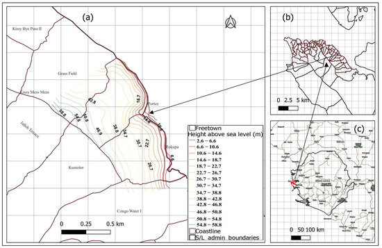
Figure 1.
Overview of Portee and Rokupa (a); Freetown City (b); and Sierra Leone (c). Shapefiles, https://data.humdata.org/dataset/cod-ab-sle; elevation: Google Earth Pro; labels in 1c, Google Labels. Accessed on 21 October 2022. Drawn: Author.
Before the re-establishment of local governments in Sierra Leone in 2004, Portee and Rokupa existed as one. Since then, their boundaries have been established and recognized [23].
Wards are the smallest political-administrative unit, headed by councillors elected after every five years [24]. All of Portee and a section of Rokupa are included in Ward 409. The remainder of Rokupa is located in Ward 408 [24]. The Freetown City Council established ward development committees, which are made up of community stakeholders and assist the councillors in carrying out their tasks. Various tribal chiefs also serve as local cultural heads [8]. The two communities fall under constituency 116, which has a parliament member elected every five years to represent them in the state house. A total of 34,502 people live in the two communities, making up about 3.4% of Freetown city’s total population. This population is concentrated in an area with a high poverty rate [3].
While it is more temperate inland, the climate is hotter and more humid along the coastline. According to the World Bank data (1991–2020), the wettest months in the Western area, including Freetown, are June, July and August, with a monthly rainfall sum of 1887.62 mm [25]. The risk of flood disasters rises when there is much rain because the Atlantic Ocean’s water level rises and overflows, adding to the inland water that overflows from rivers, streams and drainages that drain into the coastal area. Rainfall is the most critical weather condition responsible for flooding in Portee and Rokupa [25].
Previous reports have named Portee and Rokupa as hotspots for flooding [1,26]. Examples of these floods include the 25 August 2020 event, which resulted in one fatality and approximately 60 people being left homeless [27]. The flood of September 2015 had an impact on about 27 homes, nine of which were seriously damaged and three destroyed. There were also two recorded fatalities [8]. The topography and intensity of flooding have put the Portee/Rokupa wharf area at risk of mudslides and rockfalls [1].
Fishing activities have a significant impact on the social and economic elements of the coastal communities of Portee and Rokupa. This is likely because fish markets are conveniently located across the city. The wharf community’s common name, Portee–Rokupa, is derived from the names of the two settlements that make up the community. This wharf has developed over time into one of the most impressive fishing settlements east of Freetown [8].
This work was done on the coastline of Portee and Rokupa (Figure 1c) due to their vulnerability and exposure to coastal floods, and also being a recipient of urban overflows.
3. Results
3.1. Households’ Assets to Adapt to Flood
The author examined respondents’ households to know the availability and adequacy of assets as a means to adapt to flooding.
3.1.1. Natural Capital
Water is the natural capital considered in this study because of its importance in the study area; the distance to access water, the primary water infrastructure and ownership are the crucial components recorded in the field.
Most (74%) of the interviewees get water for their everyday needs within their households or neighborhood (Figure 2a). Only a few get water beyond 100 m from their residence. Most of the interviewed household representatives stated that they own a household-protected borehole or dug well (Figure 2b). Only one respondent indicated their household ownership of pipe-borne water treated by the national Guma valley water company. Still, the concern for water in Portee and Rokupa is its safety.
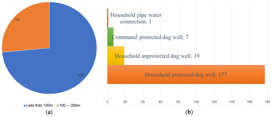
Figure 2.
Water as a natural capital to adapt to flooding. Distance from household to water source (a); infrastructure and ownership of water source (b). Obtained from: Fieldwork.
Individuals who cannot access safer drinking water are exposed to cholera, diarrhoea, typhoid and other waterborne disease conditions connected with polluted flood water. Therefore, this author argued that accessibility, affordability, availability and safety of water resources for drinking and other household uses could improve or impair inhabitants’ ability to adapt to the water-use-associated impacts of flooding.
3.1.2. Physical Capital
The author considered the material of housing walls, roofing material, household drainage system, paved floors, electricity and tenancy status as the primary physical capitals of households—which, by their quality and possession, can determine households’ ability to withstand flooding.
The vast majority (70%) of those interviewed are renters. Five percent said they are the owners, while one percent said they inherited their homes (Figure 3). The fear of being evicted at any time by the government or landlords can be related to the less investment made in making buildings durable and flood-proof, ultimately diminishing their ability to withstand floods.
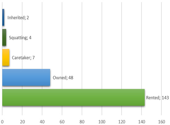
Figure 3.
Occupancy status of respondents. Source: Fieldwork.
The results show that the buildings are poorly built, with 74% of the 204 households’ walls primarily made of mud bricks. Only 24% of them are built with cement bricks, and 5% are made of corrugated metal sheets, locally called “panbody” (Figure 4). Houses are observed with foundations elevated not far from the ground level and with wall plastering that is poorly done, allowing them to quickly become moist by stagnant water.
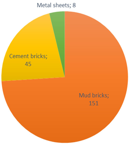
Figure 4.
Material of housing walls of participants. Source: Fieldwork.
An area in Rokupa was seen to be potentially exposed to high tides and coastal flooding due to the deforestation of the mangrove plantation (Figure 5).
Figure 5.
Cleared mangrove plantation that once protected land and other nearby structures from coastal flooding. Source: Fieldwork.
The vast majority (85.3%) of the households interviewed either have blocked drainage or are too small or poorly constructed to channel the high volume of water attributed to floods in those places (Figure 6a). One of the main community drainages was blocked during the research period. Closer to this drainage channel are poorly constructed buildings that high-impact floods can easily damage (Figure 6b).
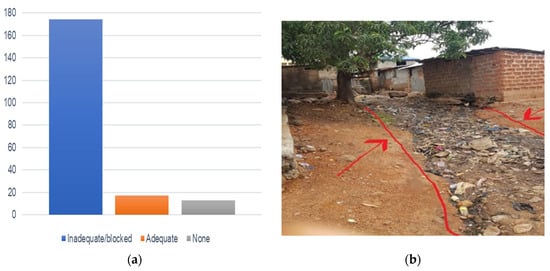
Figure 6.
The condition/ availability of households’ drainage systems (a). A blocked channel that is supposed to drain overflows from households. (b) Source: Fieldwork.
Respondents’ households (92.6%) have metal roofs (see Figure 7a). The author observed that corrugated metal roofing is the most commonly used roofing system in Portee and Rokupa. However, most of these roofs are at the end of their useful life. The rooftops were observed with several small holes that could allow water through them and be a channel for flooding during heavy downpours (Figure 7b).
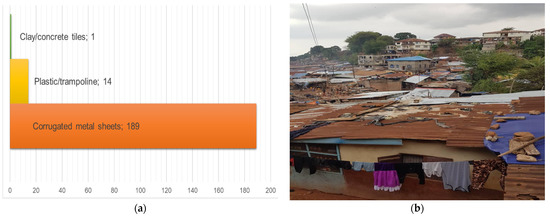
Figure 7.
The Roofing system of respondents’ households (a). An overview of the study area rooftops (b). Source: Fieldwork.
All the interviewed households affirmed their accessibility to electricity. Still, only 1.5% of the respondents claimed to be getting uninterrupted electricity for more than 16 h a day (Figure 8). The rest of them stated that they get an unstable supply of electricity. Electricity is essential for lighting, powering televisions and radios, and recharging mobile phones to ensure communication with loved ones and to receive updates in case of a flood—facilitating early warnings and preparation, thereby preventing or reducing potential flood consequences. This study associates the inadequate electricity with the lack of modern electronic means of receiving and sharing flood warnings and information in the study area.
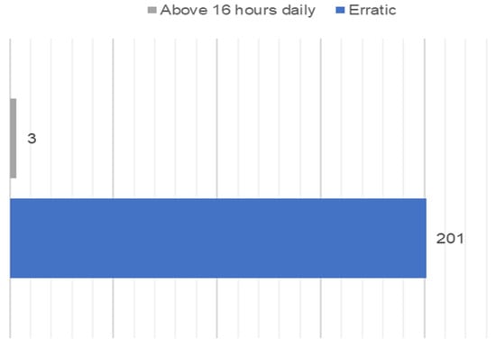
Figure 8.
Households’ access to varying times of electricity. Source: Fieldwork.
3.1.3. Financial Capital
The author recorded whether households are engaged in any livelihood activities as their financial capital to adapt to flooding. From the field results, petty trading is the most common income-generating activity among respondents, covering 50% of them (Figure 9). Sixteen percent of household representatives are not engaged in any income-generating activity. Sixteen percent of the respondents stated that they are directly involved in fishing. Most of the workers are daily wage earners. The average daily income is SLL 35.20 (the equivalent of EUR 2.49 at the research time). Among the occupations, there is an inadequate specialist to handle climate change adaptation or disaster risk reduction.
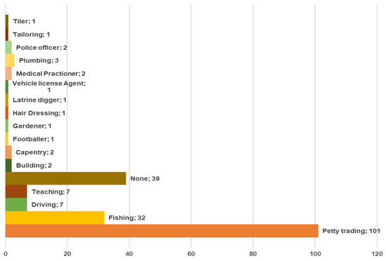
Figure 9.
Occupations of respondents. Source: Fieldwork.
3.1.4. Human Capital
The author considered formal education and training to evaluate human capital as an asset for adaptive capacity to flooding. The study area follows the national 6,3,3,4 education system, which means six years in primary school, three years in junior secondary school (JSS), three years in senior secondary school (SSS) and four years for an undergraduate degree. Respondents were asked about the highest level of education and training a household member had completed. The result shows that only 13 respondents have completed tertiary education. Tertiary education included all post-secondary education and training, including university, vocational training, etc. A worrisome amount (n = 79) of respondents have either never gone to school or attempted but did not complete any formal level of education and training (Figure 10). The high number of people with no education and training and fewer people who have completed higher education are significant factors in the lack of understanding of flood management issues and the risky conditions in which they live.
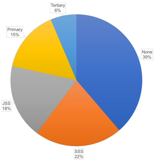
Figure 10.
Formal education and training completed by respondents as assets for flood adaptation. Source: Fieldwork.
3.1.5. Social Capital
Considering social capital as an asset for flood adaptation, the author took note of a household’s membership in community-based organizations/clubs, its preferences and the part it took in community meetings and decision-making.
A more significant number (n = 177) of interviewed households do not belong to any organization in their community (Figure 11a). Thirteen percent reported being part of an organization in their community, belonging to at least one of the following: Solar City, Destiny Sisters, Ataya Base Organization, One Family Organization, Solar Family Social Club, Kelvin Smith Organization, Virtuous/Tawopaneh, One Family, Estate Family, Posh Ladies, Seaside Rangers, Young Stars, Youth of Masjid Thywan, Tamareneh, Decent Guys and the Cry for Help Social Club.
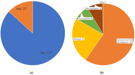
Figure 11.
Organizational membership and role in community matters. Membership of respondent in a community-based organization (a). Preference for and inclusion in community meetings and decision-making (b). Source: Fieldwork.
Considering the influence of households in community decision-making, the author interviewed participants to know their preferences and involvement in community meetings and decision-making (Figure 11). A considerable amount (n = 163) stated that they are interested in discussions and taking part in decisions that affect their communities, but they feel discriminated against. Fifty-three interviewees responded that they are included in community meetings and decisions, but passively as they are mostly just informed. Eighteen participants stated that they fully participate in all community meetings and decision-making, while another eighteen reported that they are not interested in such activities. One respondent said he is included in community matters but just in the planning phase (Figure 11b).
3.2. Knowledge of Flood Adaptation
Following the adopted framework, respondents’ knowledge about flood adaptation was assessed. Most (n = 181) of them stated that they do not know about flood adaptation (Figure 12a). Only 23 of the household’s representatives reported knowing about flood adaptation. Respondents who said they knew about flood adaptation were further asked how knowledgeable they were. Of the 23, 20 affirmed being very knowledgeable (Figure 12b). The inadequate knowledge about flood adaptation among respondents can be connected to the high number of them not going to school or only completing a basic education, which has not exposed them to such concepts.
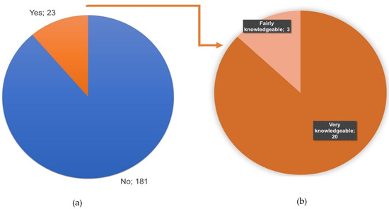
Figure 12.
A presentation of whether the interviewees know about flood adaptation (a), and how knowledgeable they are (b). Source: Fieldwork.
3.3. Institutional Entitlements to Community Institutions
Despite the low number of respondents with membership in community-based organizations, the majority (86%) of them considered their households equal entitlements to community institutions. Only 14% stated that their homes do not have equal entitlement to local institutions. Local institutions, such as churches and mosques, are built from the contributions of their congregation/well-wishers, who can sometimes determine the level of equality and influence. The named institutions can serve as a platform to share news and bring hope and emotional relief to help heal from the psychological impacts of the loss and damage associated with flooding.
3.4. Access to Improved Flood Management Technologies
Access to innovative flood management systems is fundamental in coping with and adapting to flooding. Household representatives were asked whether they have access to new and improved flood management technologies. One hundred percent of the represented households reported that they do not have access to new and improved flood management technologies. One major factor associated with the poor status of the respondents, the insufficient capacity of the national disaster management agency and the higher chances of preventable flood disasters is the lack of access to modern flood management technologies, such as flood warning and reporting mobile applications.
3.5. Flexible, Forward-Thinking Decision and Flood Governance
Only 1 out of the 204 household representatives stated that he had taken precautionary flood action. The action was placing sandbags as a water barrier to protect his house. It was observed that long-term flood governance and adaptation measures are uncommon in the study area.
Even though the inhabitants expect flood yearly, most of them only react when its consequences become a barrier to their everyday activities or threaten the safety of their lives and properties. It was observed that household waste and silt accumulated in drainages due to deposition by community members still needed to be cleared. The unwillingness to take simple and inexpensive flood mitigation measures, such as clearing blocked drainages and refraining from dumping in and blocking waterways, suggests that most of these inhabitants are beginning to accept flooding as a part of their seasonal lives.
4. Discussion
As seen from the results, the adequate availability and utilization of household asset stock profoundly influence households’ adaptive capacity. For instance, safe water for use during a catastrophic flood event is vital to households’ prevention of disease conditions associated with flood-polluted water.
Recent findings revealed that the inhabitants of the study area mainly used lined latrines and hanging toilets. The risk of these types of latrines in the coastal area is that their water level rises quickly during the rainy season and becomes a groundwater pollutant for nearby household groundwater sources, such as water wells. The pollution of unprotected wells is exacerbated during flood events. The question of water safety is a significant problem that has resulted in most community inhabitants resorting to buying sachet water for drinking purposes. Although it is costlier, its users consider sachet water safe, with the idea of the hygienic treatment and packaging processes it passes through in the factory [28].
A durable house is also a factor that will determine how much damage the inhabitants will be subjected to and how fast they can recover from a flood disaster. The income level [29] and tenancy status [30] can influence the durability and quality of a household. A previous study from Japan found that residents’ ownership of their houses significantly impacts the level of flood management efforts they take [30]. The possession of a house was crucial for its flood-proofing, according to additional findings of a study done on the inhabitants of the Rhine and Danube rivers in Germany [31]. As in Portee and Rokupa, a similar circumstance of dilapidated buildings was seen in Cockle bay, another coastal community in Freetown [9].
There are more petty traders and fishers among respondents, with inadequate specialists to handle climate change adaptation or disaster risk reduction issues. Most of the petty trading activity in this community is in support of the fishing industry [8]. According to projections by the recent IPCC report, 66% of respondents’ livelihoods (fishing and fishing-associated petty trading) in the coastline will face significant disruption by 2050, no matter the climate or socioeconomic change scenario [32]. By 2100, all other coastal livelihoods will be impacted by compounded and cascading threats if adequate adaptation measures are not taken [32].
Durable and flood-proof housing; belonging to a community-based organization; and innovative, flexible, forward-looking flood management and decision-making received the least positive responses in the field and can be considered the most adaptive deficits or deficiencies. The IPCC estimated with a high degree of confidence that these factors, along with the ongoing patterns of coastal expansion, will increase the exposure and vulnerability of inhabitants by 2050. The possibility of attaining the Sustainable Development Goals of 2030 and climate-resilient developments in the study area and all other coastal settlements in developing countries is unrealistic, given the acceleration of sea level rise and the intensification of climate-driven threats [32].
The author argues that the continuous accommodation and adjustment to annual flooding, combined with the existing adaptation deficits and inadequate flood response, has pushed residents to their adaptation limits. They are therefore fated to more loss and damage. Loss and damage are the adverse consequences of climate change to which people have not been able to adapt [33]. Such circumstances have prompted the advocacy of compensation for affected groups and the integration of disaster risk reduction and climate change adaptation interventions for a holistic solution [33,34].
As with Portee and Rokupa, many other developing territories worldwide have reached their adaptation limits. According to a study by Warner and her colleague Geest conducted in Bangladesh, Bhutan, Burkina Faso, Ethiopia, Gambia, Kenya, Micronesia, Mozambique and Nepal, many households are unable to respond to climatic change impacts and adapt. As a result, they are reaching their limits of adaptation [34].
The lack of adequate socioeconomic capabilities, driving people to live in Freetown’s slums in which easily avoidable hazards can turn into disasters, is another piece of evidence that agrees with the ongoing debate that “there is no natural disaster”. Disasters happen because humans influence the natural ecosystem. Politics and economic systems shape how the rich and poor are exposed and suffer unequally from the consequences [35].
What is promising from the field is that most respondents indicated that they have equal entitlements to community institutions. More investments are therefore needed in these institutions to empower them to serve their roles in flood adaptation.
5. Conclusions
This study has revealed critical information on how slum inhabitants in Portee and Rokupa adapt to flooding and the associated issues they face. The widespread, adaptive deficiencies are the nondurable and unflood-proofed housing; few memberships in a community-based organization; and the lack of innovative, flexible and forward-looking flood management plans and action. These concerns and the ongoing patterns of coastal expansion will increase the exposure and vulnerability of the inhabitants and are projected to put 66% of livelihoods in significant disruption by 2050, no matter the climate or socioeconomic change circumstance. This study argues that inhabitants in the study sites have reached their adaption limit and are therefore now fated to more loss and damage.
Findings contained in this study can be incorporated into nationally determined targets, such as goals 11 and 13 of the Sustainable Development Goals, the Sendai Framework on Disaster Risk Reduction and the Transform Freetown agenda. The results will also be essential to informing the flood management initiatives of institutions such as the Freetown City Council and the National Disaster Management Agency in the case and other places with similar geographical and socioeconomic characteristics.
Future statistical studies are recommended to use correlation and other relevant tests to assess the relationships between household characteristics and adaptive actions. Such studies should examine the relative strengths and weaknesses of inhabitants’ adaptive behaviors.
Multidisciplinary research—including sociology and community development studies—is required to examine, at the individual level: the reasons for the low number of belongingness to community-based organizations and clubs; and how to improve membership contribution to community-based adaptation.
Additionally, the author recommends studies to forecast and simulate the estimated portion of land area and assets in Portee and Rokupa and nearby coastal communities that will be affected by different flood intensities when subjected to varying global warming scenarios.
To improve the early learning and application of matters in this subject, the ministry of education should collaborate with the environment protection agency, the national disaster management agency and other partners to design and implement field-practical disaster risk reduction and climate change adaptation courses as early as the primary school level.
As blocked drainages remain one of the causes of flooding, the author recommends that the central government dialogue with the local people to allocate space to construct a temporary waste dumping site that will match the best environmental and public health standards. Following the site construction, the relevant central government staff and the community should jointly monitor waste dumping, and lawbreakers should be given stringent and uncompromised penalties.
Community stakeholders should consider planting mangroves in the vacant spaces in Figure 8 and other places along the coastline. The mangroves will be essential to fisheries’ habitat and can also serve as a nature-based solution to reduce coastal flood risk.
Funding
This research received no external funding.
Data Availability Statement
Data will be available upon reasonable request from the corresponding author.
Acknowledgments
Sheku Gbetuwa and Ahmed Wopa Wurie provided support for the field data collection. The author sincerely thanks the people of Portee and Rokupa for cooperating with the survey.
Conflicts of Interest
The author declares no conflict of interest.
References
- GOPA-CES. Institutional Support to Freetown City Council and to the Urban Planning Authorities. 2014. Available online: https://fdocuments.in/document/institutional-support-to-freetown-city-council-and-to-the-urban-2019-11-11-institutional.html?page=9 (accessed on 4 August 2022).
- Government of Sierra Leone. Sierra Leone National Action Plan for Health Security. November 2019. Available online: https://www.afro.who.int/publications/sierra-leone-national-action-plan-health-security-2018-2022 (accessed on 4 August 2022).
- Statistics Sierra Leone. Integrated Household Survey (SLIHS) Report; Statistics Sierra Leone: Freetown, Sierra Leone, 2019. [Google Scholar]
- Ishizawa, O.A.; Bonnafous, L.; Gaspari, M.; Gordillo, A.G.; Díaz, J.M.; Pomonis, A.; Wandel, N. Sierra Leone Disaster Risk Management Diagnostic Note; World Bank: Washington, DC, USA, 2020; Available online: http://hdl.handle.net/10986/35809 (accessed on 4 August 2022).
- Turay, B.; Gbetuwa, S. A state-of-the-art examination of disaster management in Sierra Leone: The implementation drawbacks, research gaps, advances, and prospects. Geoenviron. Disasters 2022, 9, 22. [Google Scholar] [CrossRef] [PubMed]
- Stefanidis, S.; Alexandridis, V.; Theodoridou, T. Flood Exposure of Residential Areas and Infrastructure in Greece. Hydrology 2022, 9, 145. [Google Scholar] [CrossRef]
- Qiang, Y. Flood exposure of critical infrastructures in the United States. Int. J. Disaster Risk Reduct. 2019, 39, 101240. [Google Scholar] [CrossRef]
- Macarthy, J.M.; Frediani, A.A.; Kamara, S.F.; Morgado, M.; Exploring the Role of Empowerment in Urban Humanitarian Responses in Freetown. IIED. 2017. Available online: www.iied.org (accessed on 4 August 2022).
- Wright, C.; Carli, B.D.; Morley, S.; Macarthy, J.; Kamara, S.; Sellu, S.A.; Bangura, I.B.; Kamara, M.S.; Frediani, A.A. Change by Design: Cockle Bay Community Action Area Plan; SLURC: Freetown, Sierra Leone, 2018. [Google Scholar]
- Cumming, A. Youth Volunteerism and Disaster Risk Reduction: A Research Report on the Motivations for Young People Volunteering in Urban Slums of Freetown, Sierra Leone; YCARE International: Freetown, Sierra Leone, 2012. [Google Scholar]
- Adelekan, I.O. Vulnerability of poor urban coastal communities to flooding in Lagos, Nigeria. Environ. Urban. 2010, 22, 433–450. [Google Scholar] [CrossRef]
- John, R. Flooding in Informal Settlements: Potentials and Limits for Household Adaptation in Dar es Salaam City, Tanzania. Am. J. Clim. Chang. 2020, 9, 68–86. [Google Scholar] [CrossRef]
- IPCC. Climate Change 2007: Impacts, Adaptation, and Vulnerability; Cambridge University Press: Cambridge, UK, 2007. [Google Scholar]
- Filho, W.L.; Balogun, A.-L.; Olayide, O.E.; Azeiteiro, U.M.; Ayal, D.Y.; Muñoz, P.D.C.; Nagy, G.J.; Bynoe, P.; Oguge, O.; Toamukum, N.Y.; et al. Assessing the impacts of climate change in cities and their adaptive capacity: Towards transformative approaches to climate change adaptation and poverty reduction in urban areas in a set of developing countries. Sci. Total Environ. 2019, 692, 1175–1190. [Google Scholar] [CrossRef] [PubMed]
- Elrick-Barr, C.E.; Preston, B.L.; Thomsen, D.C.; Smith, T.F. Toward a new conceptualization of household adaptive capacity to climate change: Applying a risk governance lens. Ecol. Soc. 2014, 19, art12. [Google Scholar] [CrossRef]
- Mesfin, D.; Simane, B.; Belay, A.; Recha, J.; Schmiedel, U. Assessing the Adaptive Capacity of Households to Climate Change in the Central Rift Valley of Ethiopia. Climate 2020, 8, 106. [Google Scholar] [CrossRef]
- Government of Sierra Leone. Sierra Leone National Adaptation Plan; Fordham University Press: New York, NY, USA, 2021; Available online: https://www4.unfccc.int/sites/NAPC/Pages/national-adaptation-plans.aspx (accessed on 24 September 2022).
- Jones, L.; Ludi, E.; Levine, S. Towards a Characterization of Adaptive Capacity: A Framework for Analyzing Adaptive Capacity at the Local Level. 2010. Available online: http://ssrn.com/abstract=2782323 (accessed on 4 August 2022).
- DFID. Sustainable Livelihoods Guidance Sheets. 1999. Available online: www.dfid.gov.uk/ (accessed on 4 August 2022).
- Dulal, H.B.; Brodnig, G.; Onoriose, C.G.; Thakur, H.K. Capitalizing on Assets: Vulnerability and Adaptation to Climate Change in Nepal; The World Bank: Washington, DC, USA, 2010; p. 121. [Google Scholar]
- Sharma, G. Pros and cons of different sampling techniques. Int. J. Appl. Res. 2017, 3, 749–752. [Google Scholar]
- Lakshminarasimhappa, M.C. Web-Based and Smart Mobile App for Data Collection: Kobo Toolbox/Kobo Collect. J. Indian Libr. Assoc. 2021, 57, 72–79. Available online: https://www.ilaindia.net/jila/index.php/jila/article/view/596 (accessed on 25 July 2022).
- Government of Sierra Leone. The Local Government Act, Vol. CXXXV. 2004. p. 38. Available online: http://www.sierra-leone.org/Laws/2004-1p.pdf (accessed on 4 August 2022).
- NEC-SL. Ward Boundary Delimitation Report; National Electoral Commissio: Freetown, Sierra Leone, 2017. [Google Scholar]
- World Bank. Sierra Leone—Climatology|Climate Change Knowledge Portal. 2021. Available online: https://climateknowledgeportal.worldbank.org/ (accessed on 5 August 2022).
- The World Bank. Sierra Leone Multi-City Hazard Review and Risk Assessment. 2017. Available online: https://fdocuments.in/document/institutional-support-to-freetown-city-council-and-to-the-urban-2019-11-11-institutional.html?page=7 (accessed on 4 August 2022).
- Politico-SL. Councillor Calls for Support for Portee Flood Victims after One Dies of Hypertension. 2020. Available online: https://www.politicosl.com/articles/councilor-calls-support-portee-flood-victims-after-one-dies-hypertension%E2%80%A6 (accessed on 6 November 2022).
- Tumwebaze, I.K.; Hrdličková, Z.; Labor, A.; Turay, A.; Macarthy, J.M.; Chmutina, K.; Scott, R.; Kayaga, S.; Koroma, B.; Howard, G. Water and sanitation service levels in urban informal settlements: A case study of Portee-Rokupa in Freetown, Sierra Leone. J. Water Sanit. Hyg. Dev. 2022, 12, 612–621. [Google Scholar] [CrossRef]
- Kim, H.; Woosnam, K.M.; Marcouiller, D.W.; Kim, H. Seeking anticipatory adaptation: Adaptive capacity and resilience to flood risk. Environ. Hazards 2022, 21, 36–57. [Google Scholar] [CrossRef]
- Takao, K.; Motoyoshi, T.; Sato, T.; Fukuzondo, T.; Seo, K.; Ikeda, S. Factors determining residents’ preparedness for floods in modern megalopolises: The case of the Tokai flood disaster in Japan. J. Risk Res. 2004, 7, 775–787. [Google Scholar] [CrossRef]
- Thieken, A.H.; Kreibich, H.; Müller, M.; Merz, B. Coping with floods: Preparedness, response and recovery of flood-affected residents in Germany in 2002. Hydrol. Sci. J. 2007, 52, 1016–1037. [Google Scholar] [CrossRef]
- Glavovic, B.; Dawson, R.; Chow, W.; Garschagen, M.; Haasnoot, M.; Singh, C.; Thomas, A. Cross-Chapter Paper 2: Cities and Settlements by the Sea. In Climate Change 2022: Impacts, Adaptation and Vulnerability. Contribution of Working Group II to the Sixth Assessment Report of the Intergovernmental Panel on Climate Change; Cambridge University Press: Cambridge, UK, 2022; pp. 2163–2194. [Google Scholar] [CrossRef]
- Surminski, S.; Lopez, A. Concept of loss and damage of climate change—A new challenge for climate decision-making? A climate science perspective. Clim. Dev. 2014, 7, 267–277. [Google Scholar] [CrossRef]
- Warner, K.; Van der Geest, K. Loss and damage from climate change: Local-level evidence from nine vulnerable countries. Int. J. Glob. Warm. 2013, 5, 367–386. [Google Scholar] [CrossRef]
- Smith, N. There’s No Such Thing as a Natural Disaster; Social Science Research Council: New York, NY, USA, 2006; pp. 1–7. [Google Scholar]
Publisher’s Note: MDPI stays neutral with regard to jurisdictional claims in published maps and institutional affiliations. |
© 2022 by the author. Licensee MDPI, Basel, Switzerland. This article is an open access article distributed under the terms and conditions of the Creative Commons Attribution (CC BY) license (https://creativecommons.org/licenses/by/4.0/).