Urban Coastal Flood-Prone Mapping under the Combined Impact of Tidal Wave and Heavy Rainfall: A Proposal to the Existing National Standard


Abstract
:1. Introduction
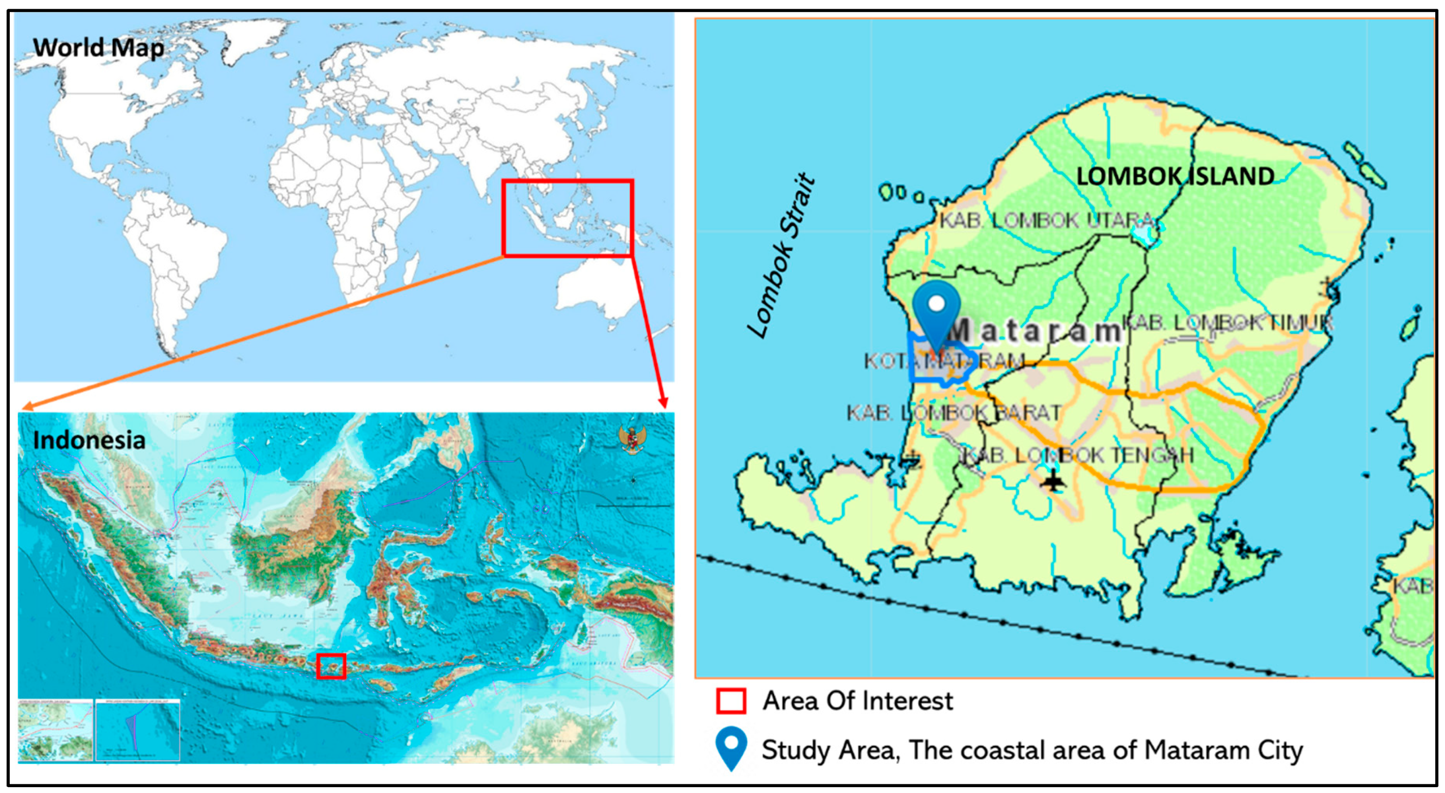
Study Area
2. Materials and Methods
- (a)
- Tidal data obtained from the website of Tide Observation and Prediction—Geospatial Information Agency (we referred to BIG: “Badan Informasi Geospasial” in Indonesian) (http://tides.big.go.id). The average of highest tidal data was assessed after data acquisition.
- (b)
- The rainfall data obtained from the website of the Tropical Rainfall Measuring Mission/TRMM (https://trmm.gsfc.nasa.gov) The National Aeronautics and Space Administration (NASA), USA. The maximum average of 10 years of rainfall data was assessed.
- (c)
- The land-use/land cover data obtained from the BIG digital Rupabumi map (base map) of Mataram City at a 1:5000 scale.
- (d)
- The slope data obtained from the BIG seamless digital elevation model (DEM) and National Bathymetry website (https://tides.big.go.id/DEMNAS). The digital terrain model (DTM) data were obtained within a 0.27-arc-second spatial resolution and converted into a slope by using the 3D analyst of GIS software.
- (e)
- The geomorphological data extracted and assessed from the digital land system map of Mataram City, published by BIG at a 1:25,000 scale and the digital soil map from the Indonesian Center for Agriculture Land Resources Research and Development at a 1:50,000 scale, Bogor- Indonesia.
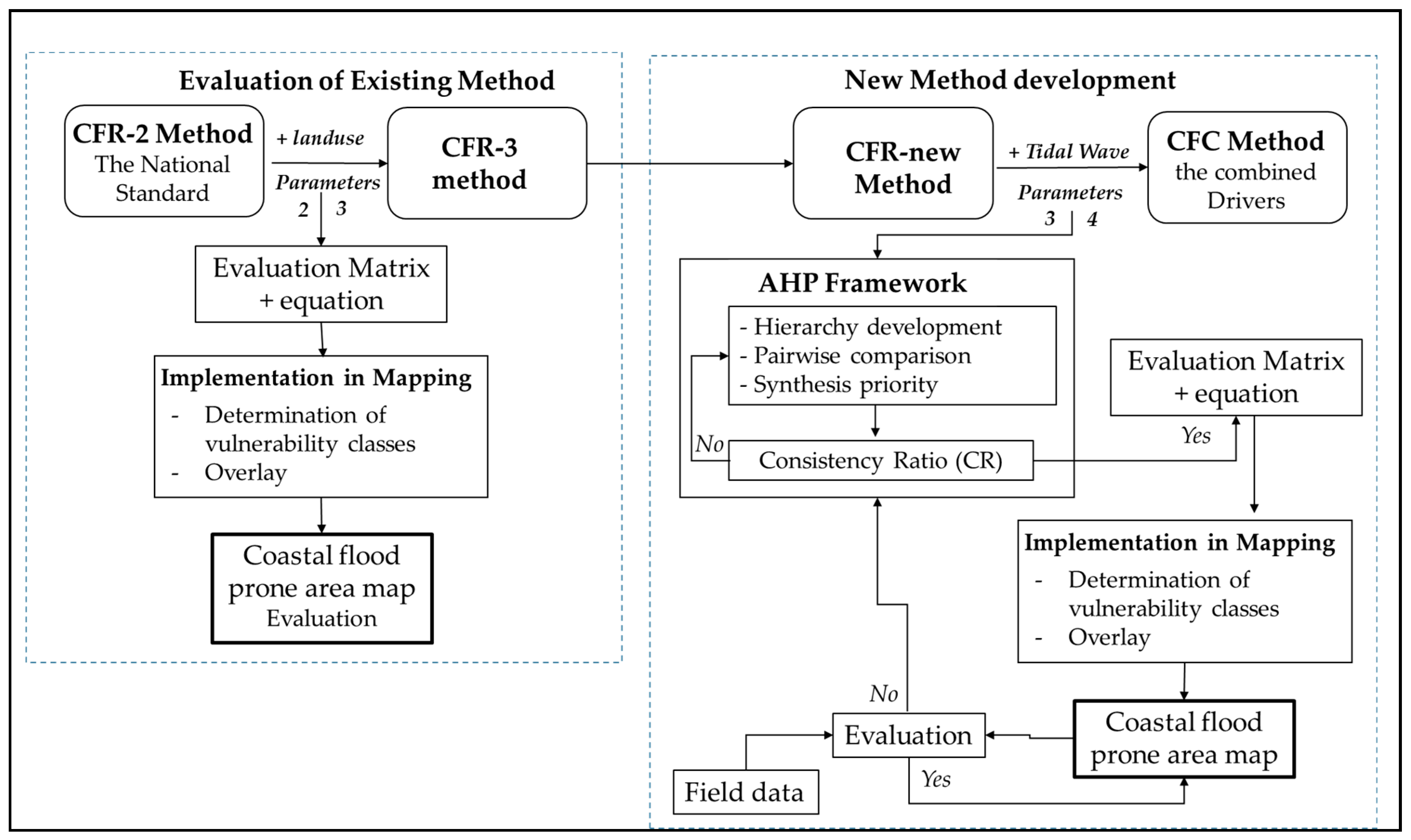
2.1. Evaluation of the Existing Method
2.2. New Method Development
2.2.1. CFR-New method
2.2.2. CFC Method Development
2.2.3. Implementation of the Methods in Mapping
2.2.4. Field data inventory
2.2.5. Evaluation
3. Results
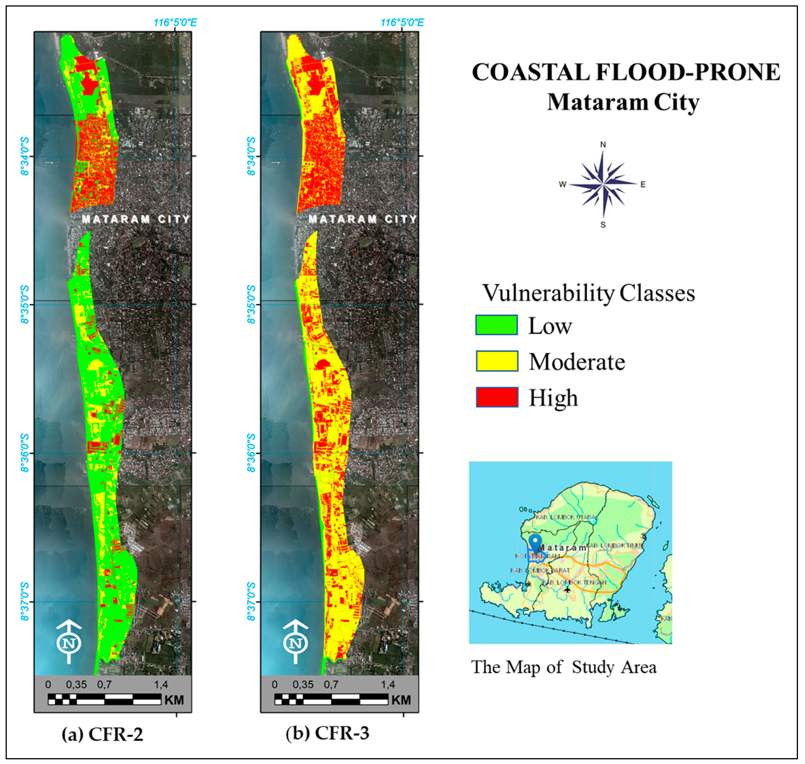
3.1. Coastal Flood-Prone Area Method Based on Rainfall
3.2. Coastal Flood-Prone Area Method Based on Combined Drivers
4. Discussion
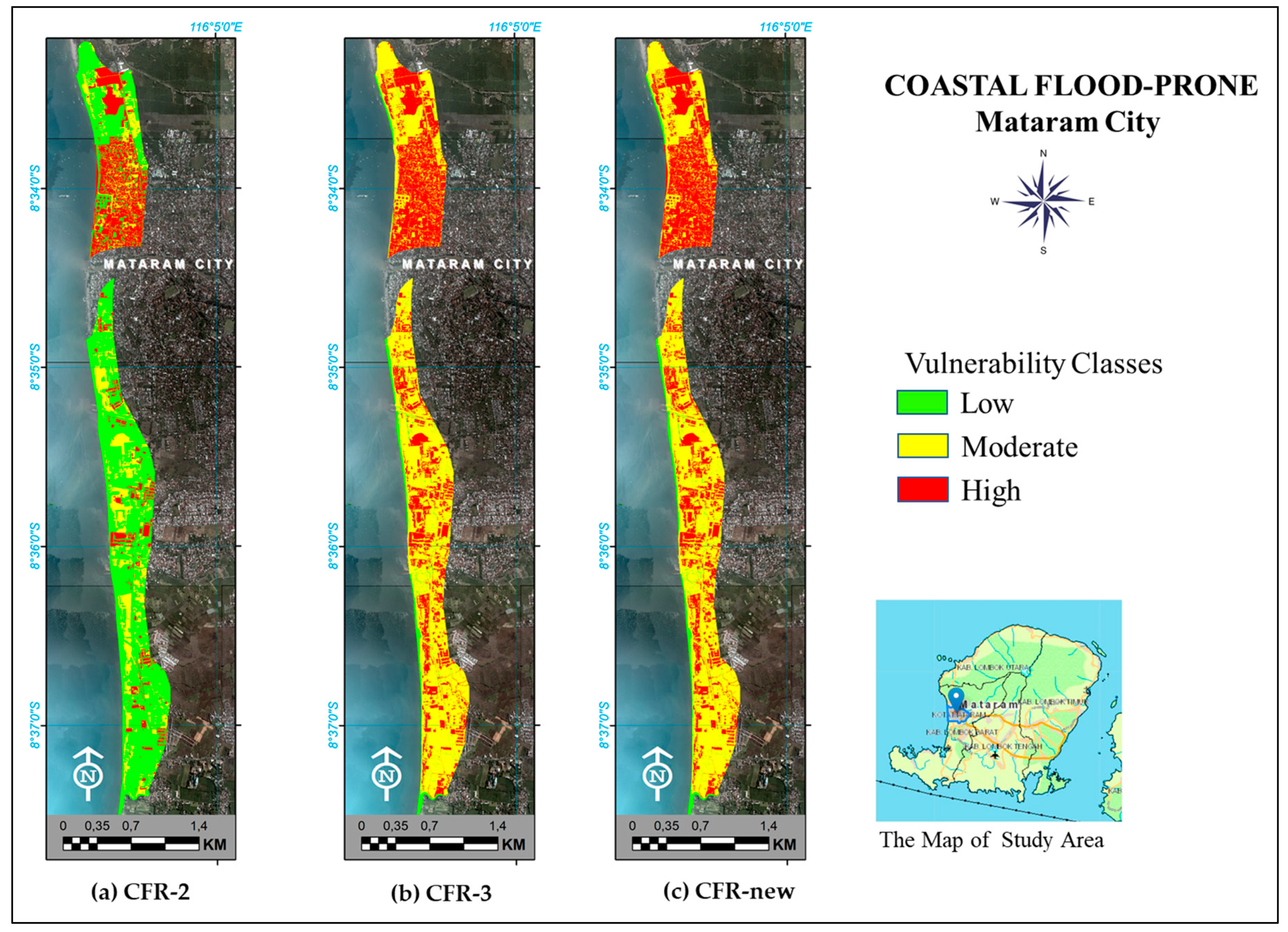
- Land cover is essential for the CFR and CFC methods: [30] shows the empirical link of flooding to land use and land cover conversion that plays a vital role in the occurrence of flooding. Table 5 showed the increase of high and moderate vulnerability classes when the land cover/use parameter was added, with 42.63 ha for the high class and 125.56 ha for the moderate class from CR-2 to CR-3, respectively.
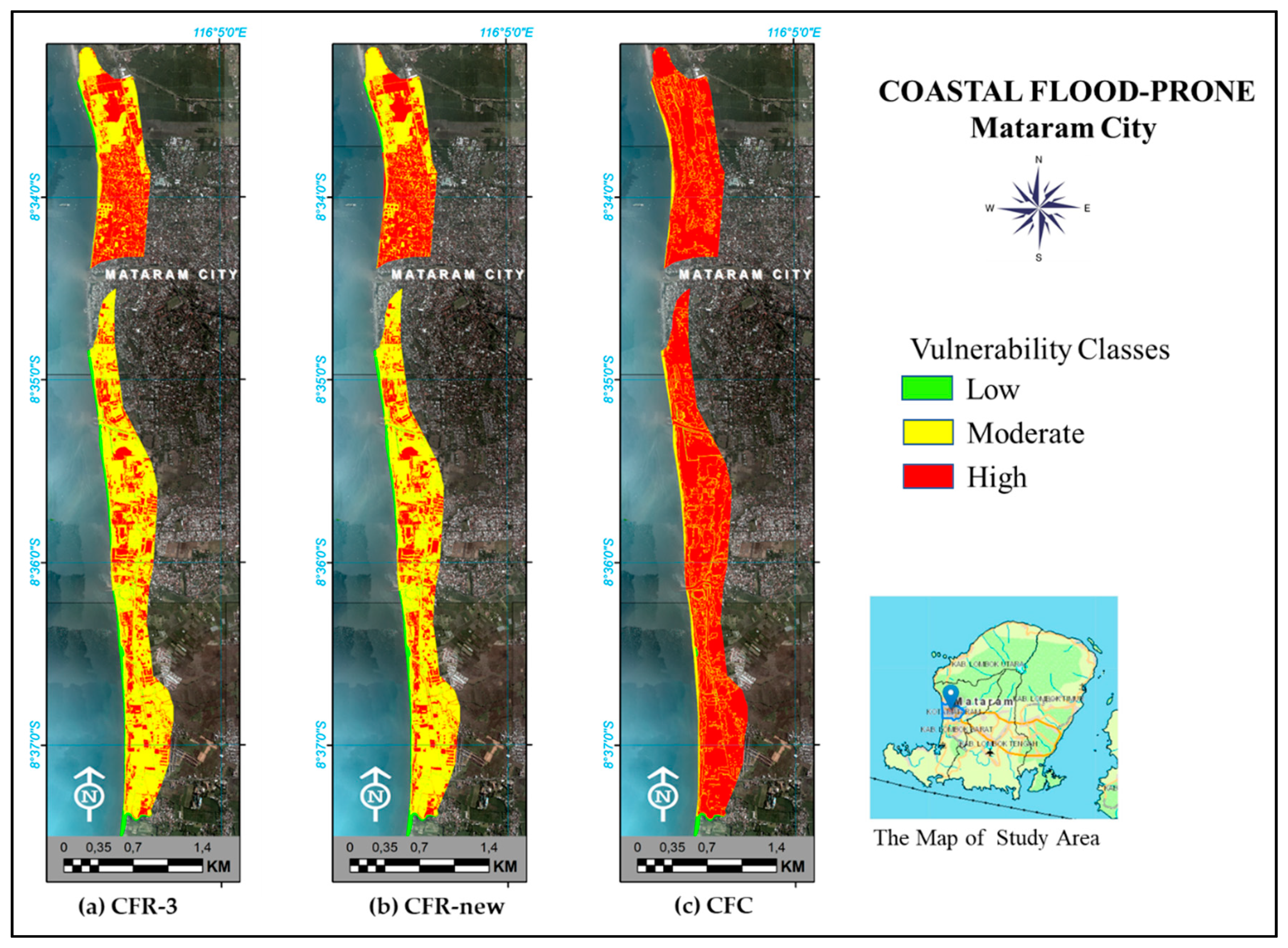
- The CFC method allows more detailed impacts on the land: [44,45] supports that coastal and deltaic areas are susceptible to flooding from the combined effects of excess rainfall and astronomic tide inundations. Table 8 describes the differences in susceptibility of the moderate and low classes in CFR-3 and CFR-new, with 142.74 ha and 140.18 ha, respectively, to CFC while an extreme tidal wave was added to the model.
- Flooding depends on geomorphological units: [46] supports the importance of hydro-geomorphological aspects for coastal flood mapping in that an alluvial plain can be used to delineate flood hazard areas based on his research in Constantine City, Algeria. The geomorphological type of the Mataram City coast is an alluvial plain. As can be seen in Figure 6, using either the CFR or CFC method, the alluvial plain area in the study site is vulnerable to flooding and can be used as a mapping unit. The observation area indicates that the highest tidal wave caused a dynamic form of the alluvial plain, which sometimes created a sand embankment along the coast of Mataram City. This condition may intensify the inundation of the area, especially in low areas that are blocked by sand embankments. In his research in Vietnam, [47] indicated that flooding and the dynamic mechanism of alluvial formation were correlated and, in turn, affected the flooding hazard.
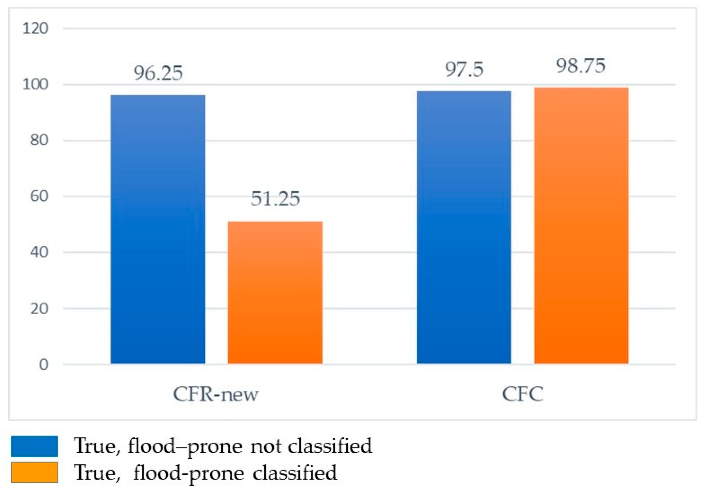
Evaluation of the CFR-new and CFC methods
5. Conclusions
Author Contributions
Funding
Acknowledgments
Conflicts of Interest
References
- Wolf, J. Coastal flooding: Impacts of coupled wave-surge-tide models. Nat. Hazards 2008, 49, 241–260. [Google Scholar] [CrossRef] [Green Version]
- Lewis, M.J.; Palmer, T.; Hashemi, R.; Robins, P.; Saulter, A.; Brown, J.; Lewis, H.; Neill, S. Wave-tide Interaction Modulates Nearshore Wave Height. Ocean Dyn. 2019, 69, 367–384. [Google Scholar] [CrossRef] [Green Version]
- Zai, V.R.C. Arahan Dan Rekomendasi Pemanfaatan Lahan Untuk Kawasan Permukiman Wilayah Pesisir Kelurahan Tanjung Mas Dan Kelurahan Bandarharjo (Directions and Recommendatins of Utilization to a Residential Coastal Area in Tanjung Mas and Bandarharjo District). In Proceedings of the Seminar Nasional Geomatika 2018, Bogor, Indonesia, 5 September 2018. [Google Scholar] [CrossRef]
- Ramsay, D.B.; Bell, R. Coastal Hazards and Climate Change. A Guidance Manual for Local Government in New Zealand, 2nd ed.; Ministry for the Environment: Wellington, New Zealand, 2008.
- Purbani, D.; Salim, H.L.; Kusuma, L.P.A.S.C.; Tussadiah, A.; Subandriyo, J. Ancaman gelombang ekstrim dan abrasi pada penggunaan lahan di pesisir Kepulauan Karimunjawa (Studi kasus: Pulau Kemujan, Pulau Karimunjawa, Pulau Menjangan Besar dan Pulau Menjangan Kecil)/The extreme waves and abrasion hazards on coastal land use at Karimunjawa Islands (Case Study: Kemujan Island, Karimunjawa Island, Menjangan Besar Island and Menjangan Kecil Island). J. Kelaut. Nas. 2019, 14, 33–45. [Google Scholar]
- Center for Disease Control and Public Health. Coastal Flooding, Climate Change, and Your Health What You Can Do to Prepare; US Departement of Health and Human Services, Center for Disease Control and Prevention: Atlanta, GA, USA, 2017.
- Handayani, W.; Fisher, M.R.; Rudiarto, I.; Setyono, J.S.; Foley, D. Operationalizing resilience: A content analysis of flood disaster planning in two coastal cities in Central Java, Indonesia. Int. J. Disaster Risk Reduct. 2019, 35, 1–12. [Google Scholar] [CrossRef]
- Nugraha, A.L.; Santoso, B.P.; Aditya, T. Dissemination of tidal Flood Risk Map using Online Map in Semarang. Proceedings ICTCRED (International Conference on Tropical and Coastal Region Eco-Development) 2015. Proc. Environ. Sci. 2015, 23, 64–71. [Google Scholar] [CrossRef] [Green Version]
- Griggs, G.; Davar, L.; Reguero, B.G. Documenting a century of coastline change along Central California and associated challenges: From the qualitative to the quantitative. Water 2019, 11, 2648. [Google Scholar] [CrossRef] [Green Version]
- Nirwansyah, A.W.; Boris, B. Mapping impact of tidal flooding on solar salt farming in Northern Java using a hydrodynamic model. ISPRS Int. J. Geo Inf. 2019, 8, 451. [Google Scholar] [CrossRef] [Green Version]
- Hamdani, H.; Perman, S.; Susetyaningsih, A. Analisa daerah rawan banjir menggunakan aplikasi sistem informasi geografis (Studi kasus Pulau Bangka). J. Konstr. Sekol. Tinggi Teknol. Garut 2014, 12, 1–13. [Google Scholar]
- Badan Standarisasi Nasional. SNI 8197:2015 Metode Pemetaan Rawan Banjir sekala 1:50,000 dan 1:25,000; Badan Standarisasi Nasional: Jakarta, Indonesia, 2015.
- Roy, S.L.; Pedreros, R.; André, C.; Paris, F.; Lecacheux, S.; Marche, F.; Vinchon, C. Coastal flooding of urban areas by overtopping: Dynamic modelling application to The Johanna Storm (2008) in Gâvres (France). Nat. Hazards Earth Syst. Sci. 2015, 15, 2497–2510. [Google Scholar] [CrossRef] [Green Version]
- Badan Nasional Penanggulangan Bencana (Ed.) Peraturan Kepala Badan Nasional Penanggulangan Bencana No. 2/2012 Tentang Pedoman Umum Pengkajian Risiko Bencana, Dengan Parameter Tinggi Gelombang, Arus, Tutupan Vegetasi, Bentuk Garis Pantai Dan Tipologi Pantai, Difokuskan Di Daerah Sempadan Pantai; Badan Nasional Penanggulangan Bencana: Jakarta, Indonesia, 2012. [Google Scholar]
- Olbert, A.I.; Comer, J.; Nash, S.; Harnett, M. High-resolution multi-scale modelling of coastal flooding due to tides, storm surges and rivers inflows. A Cork City example. Coast. Eng. 2017, 121, 278–296. [Google Scholar] [CrossRef]
- Purba, M.; Utami, I.N. Karakter dan pergerakan masa air di Selat Lombok bulan Januari 2004 dan Juni 2006 (Characteristics and circulation of water mass at Lombok Strait in January 2004 and June 2006). J. Ilmu Ilmu Perair. Perikan. Indones. 2006, 13, 143–153. [Google Scholar]
- Bappeda Provinsi Nusa Tenggara Barat. Kajian Resiko Bencana Kota Mataram (The Assessment of Disaster Risk in Mataram City); Bappeda Provinsi Nusa Tenggara Barat: Mataram, Indonesia, 2019.
- Rahmanto, M.R.; Susetyo, C. Pemodelan spasial genangan banjir akibat gelombang pasang di wilayah pesisir Kota Mataram. J. Tek. ITS 2017, 7, 2337–3520. [Google Scholar] [CrossRef] [Green Version]
- Suara NTB. Warga Pesisir Pantai di Mataram Butuh Pemecah Gelombang. SuaraNTB.com, 30 July 2018. [Google Scholar]
- Sulistiyono, H.; Pradjoko, E.; Syamsidik. Effect of Climate Change Variables on The Coastal Wind Prediction. In Proceedings of the 21st IAHR-APD Congress, Yogyakarta, Indonesia, 2–5 September 2018; Departement of Civil and Environmental Engineering, Gadjahmada University: Yogjakarta, Indonesia, 2018; pp. 549–558.
- Warsilah, H.; Nadila, S.M. Inclusive Urban Coastal Development in Ampenan and Jerowaru, West Nusa Tenggara. In Proceedings of the 2nd International Conference on Strategic and Global Studies (ICSGS), Central Jakarta, Indonesia, 24–26 October 2018. [Google Scholar] [CrossRef] [Green Version]
- Peta NKRI. Peta Pulau Lombok. Available online: https://tanahair.indonesia.go.id/portal-web/download/perwilayah (accessed on 11 August 2020).
- World Map. Available online: http://sahimiqm.blogspot.com/2017/01/peta-dunia-kosong.html (accessed on 13 August 2020).
- Helderop, E.; Grubesic, T.H. Social, geomorphic, and climatic factors driving U.S. coastal city vulnerability to storm surge flooding. Ocean Coast. Manag. 2019, 181, 1–11. [Google Scholar] [CrossRef]
- Manfreda, S.; Nardi, F.; Samela, C.; Grimaldi, S.; Taramasso, A.C.; Roth, G.; Sole, A. Investigation on the use of geomorphic approaches for the delineation of flood prone areas. J. Hydrol. 2014, 517, 863–876. [Google Scholar] [CrossRef]
- Samela, C.; Troy, T.J.; Manfreda, S. Geomorphic classifiers for flood-prone areas delineation for data-scarce environments. Adv. Water Resour. 2017, 102, 13–28. [Google Scholar] [CrossRef]
- Berndtsson, R.; Becker, P.; Persson, A.; Aspegren, H.; Haghighatafshar, S.; Jönsson, K.; Larsson, R.; Mobini, S.; Mottaghi, M.; Nilsson, J.; et al. Drivers of changing urban flood risk: A framework for action. J. Environ. Manag. 2019, 240, 47–57. [Google Scholar] [CrossRef]
- Lin, W.B.; Sun, Y.M.; Nijhuis, S.; Wang, Z. Scenario-based flood risk assessment for urbanizing deltas using future land-use simulation (FLUS): Guangzhou Metropolitan Area as a ccase study. Sci. Total Environ. 2020, 739, 1–10. [Google Scholar] [CrossRef]
- Canters, F.; Vanderhaegen, S.; Khan, A.Z.; Engelen, G.; Uljee, I. Land-use simulation as a supporting tool for flood risk assessment and coastal safety planning: The case of The Belgian Coast. Ocean Coast. Manag. 2014, 101, 102–113. [Google Scholar] [CrossRef]
- Avashia, V.; Garg, A. Implications of land use transitions and climate change on local flooding in urban areas: An assessment of 42 Indian cities. Land Use Policy 2020, 95, 1–9. [Google Scholar] [CrossRef]
- Sushanti, I.R.; Imansyah, N.H. Kajian perubahan fisik spasial kawasan urban fringe di Kecamatan Ampenan Kota Mataram. J. Planoearth 2018, 3, 44–48. [Google Scholar] [CrossRef]
- Lathrop, R.; Lisa, A.; James, T.; Bognar, J. The Application of webgis tools for visualizing coastal flooding vulnerability and planning for resiliency: The New Jersey Experience. ISPRS Int. J. Geo Inf. 2014, 3, 408–429. [Google Scholar] [CrossRef]
- Xu, Y.; Lu, Y. Adaptive weighted fusion: A novel fusion approach for image classification. Neurocomputing 2015, 168, 566–574. [Google Scholar] [CrossRef]
- Tercan, E.; Dereli, M.A. Development of a land suitability model for citrus cultivation using GIS And multi-criteria assessment techniques in Antalya Province of Turkey. Ecol. Indic. 2020, 117, 1–11. [Google Scholar] [CrossRef]
- Bagdanaviciute, I.; Kelpsaite, L.; Soomere, T. Multi-criteria evaluation approach to coastal vulnerability index development in micro-tidal low-lying areas. Ocean Coast. Manag. 2015, 104, 24–135. [Google Scholar] [CrossRef]
- Kudláč, Š.; Majercak, J.; Štefancová, V. Using the Saaty Method and the FMEA Method for Evaluation of Constraints in Logistics Chain. Procedia Eng. 2019, 187. [Google Scholar] [CrossRef]
- Liu, F.; Zou, S.C.; Li, Q. Deriving priorities from pairwise comparison matrices with a novel consistency index. Appl. Math. Comput. 2020, 364, 1–15. [Google Scholar] [CrossRef]
- Sutrisno, D.; Windiastuti, R.; Oktaviani, N.; Rudiastuti, A.W. A feasibility study of seabed cover classification standard in generating related geospatial data. Geo Spat. Inf. Sci. 2019, 22, 304–313. [Google Scholar] [CrossRef] [Green Version]
- Chu, P.; Liu, J.K.H. Note on consistency ratio. Math. Comput. Model. 2002, 35, 1077–1081. [Google Scholar] [CrossRef]
- Liu, F.; Zhang, J.W.; Zhang, W.G.; Pedrycz, W. Decision making with a sequential modeling of pairwise comparison process. Knowl. Based Syst. 2020, 1–46. [Google Scholar] [CrossRef]
- Haryani, N.S. Analisis Zona Potensi Rawan Banjir Menggunakan Data Penginderaan Jauh dan SIG di Kalimantan Timur. In Proceedings of the Seminar Nasional Penginderaan Jauh ke-4 Tahun 2017, Jakarta, Indonesia, 17 October 2017; LAPAN: Depok, Indonesia, 2017. [Google Scholar]
- Rosyiedie, A. Banjir: Fakta dan dampaknya serta pengaruh dari perubahan lahan. J. Perenc. Wil. Dan Kota 2013, 24, 241–249. [Google Scholar]
- Wismarini, T.D.; Syukur, M. Penentuan tingkat kerentanan banjir secara geospasial. J. Teknol. Inf. Din. 2018, 20, 57–76. [Google Scholar]
- Xie, D.; Zou, Q.P.; Mignone, A.; MacRae, J.D. Coastal flooding from wave overtopping and sea level rise adaptation in the Northeastern USA. Coast. Eng. 2019, 150, 39–58. [Google Scholar] [CrossRef]
- Bilskie, M.V.; Hagen, S.C. Defining flood zone transitions in low- gradient coastal regions. Geophys. Res. Lett. 2018, 45, 2761–2770. [Google Scholar] [CrossRef]
- Bourenanea, H.; Bouhadada, Y.; Guettouche, M.S. Flood hazard mapping in urban area using the hydro-geomorphological approach: Case study of the Boumerzoug and Rhumel Alluvial Plains (Constantine City, NE Algeria). J. Afr. Earth Sci. 2019, 160, 1–8. [Google Scholar] [CrossRef]
- Ho, L.T.K.; Umitsu, M. Micro-landform classification and flood hazard assessment of The Thu Bon Alluvial Plain, Central Vietnam via an integrated method utilizing remotely sensed data. Appl. Geogr. 2011, 31, 1082–1093. [Google Scholar] [CrossRef]
- He, H.; Di, H.; Qun, S.; Lei, Z.; Yanrong, L.A. A landslide susceptibility assessment method based on GIS technology and an AHP-weighted information content method: A case study of Southern Anhui, China. ISPRS Int. J. Geo Inf. 2019, 8, 266. [Google Scholar] [CrossRef] [Green Version]
- Drobne, S.; Lisac, A. Multi-attribute decision analysis in GIS: Weighted linear combination and ordered weighted averaging. Informatica 2009, 33, 459–475. [Google Scholar]
- Sekovski, I.; Del Rio, L.; Armaroli, C. Development of a coastal vulnerability index using analytical hierarchy process and application to Ravenna Province (Italy). Ocean Coast. Manag. 2019, 1–11. [Google Scholar] [CrossRef]
- Kumbier, K.; Carvalho, R.C.; Vafeidis, A.T.; Woodroffe, C.D. IInvestigating compound flooding in an estuary using hydrodynamic modelling: A case study from The Shoalhaven River, Australia. Aust. Nat. Hazards Earth Syst. Sci. 2018, 18, 463–477. [Google Scholar] [CrossRef] [Green Version]
- Shen, Y.; Morsy, M.M.; Huxley, C.; Tahvildari, N.; Goodall, J.L. Flood risk assessment and increased resilience for coastal urban watersheds under the combined impact of storm tide and heavy rainfall. J. Hydrol. 2019, 1–46. [Google Scholar] [CrossRef]
- Zhang, Y. An Integrated Framework to Assess Compound Flood Risks for Interdependent Critical Infrastructure in A Coastal Environment. Master’s Thesis, Graduate Program in Civil and Environmental Engineering, The University of Western, London, ON, Canada, 2019. [Google Scholar]
- Lee, S.; Kang, T.; Sun, D.; Park, J.J. Enhancing an analysis method of compound flooding in coastal areas by linking flow simulation models of coasts and watershed. Sustainability 2020, 12, 6527. [Google Scholar] [CrossRef]


| Parameter | w | CFR-2 Classes | w | CFR-3 Classes | ||||||||||
|---|---|---|---|---|---|---|---|---|---|---|---|---|---|---|
| High | S | Moderate | S | Low | S | High | S | Moderate | S | Low | S | |||
| Slope | 70 | 0–2% | 3 | 2–4% | 2 | >4% | 1 | 35 | 0–2% | 3 | 2–4% | 2 | >4% | 1 |
| Land cover/use | 35 | Settlements | 3 | Bushes/agriculture/mixed crops/plantations | 2 | Rice fields/forest/gardens/sand/bare land | 1 | |||||||
| Rainfall | 30 | ≥200 mm | 3 | 50–200 mm | 2 | ≤50 mm | 1 | 30 | ≥200 mm | 3 | 50–200 mm | 2 | ≤50 mm | 1 |
| Flood-Prone Area | Class Interval | Vulnerability Classes | |
|---|---|---|---|
| Flood-Prone Classes | |||
| >Y–Z | |||
| >X–Y | |||
| = X | 0–X | ||
| Land Cover/Use | Slope | Rainfall | ∑ Row | Eigenvector | Results | Weight | Weighted Sum Vector (WSV) | Consistency Vector (CV) | |
|---|---|---|---|---|---|---|---|---|---|
| Land cover/use | 1 | 3 | 5 | 1.90 | 0.6333 | 1.2033 | 1.20 | 1.9458 | 3.0725 |
| Slope | 0.33 | 1 | 3 | 0.78 | 0.2605 | 0.2032 | 0.20 | 0.7902 | 3.0334 |
| Rainfall | 0.20 | 0.33 | 1 | 0.32 | 0.1062 | 0.0340 | 0.03 | 0.3197 | 3.0103 |
| λ | 3.0387 | ||||||||
| Consistency Index (CI) | 0.0194 | ||||||||
| Consistency Ratio (CR) | 0.0334 | ||||||||
| Parameter | Weighting | Classification of the Coastal Flood-prone Area | |||||
|---|---|---|---|---|---|---|---|
| High | Score | Moderate | Score | Low | Score | ||
| Land cover/use | 1.20 | Settlements | 3 | Bushes/agriculture/mixed crops/plantations | 2 | Rice fields/forest/gardens/sand/bare land | 1 |
| Slope | 0.20 | 0–2% | 3 | 2–4% | 2 | 4% | 1 |
| Rainfall | 0.03 | ≥200 mm | 3 | 50–200 mm | 2 | ≤50 mm | 1 |
| Prone Classes | Area (ha) | ||
|---|---|---|---|
| CFR-2 | CFR-3 | CFR-New | |
| High | 58.65 | 101.28 | 103.84 |
| Moderate | 56.98 | 182.54 | 179.98 |
| Low | 183.09 | 14.90 | 14.90 |
| Slope | Tidal Wave Inundation | Land Cover/Use | Rainfall | ∑ Rows | Eigen Vector | Result | Weight | Weighted Sum Vector (WSV) | Consistency Vector (CV) | |
|---|---|---|---|---|---|---|---|---|---|---|
| Slope | 1 | 3 | 5 | 7 | 2.23 | 0.5579 | 1.2441 | 1.24 | 2.3556 | 4.2223 |
| tidal wave inundation | 0.33 | 1 | 3 | 5 | 1.05 | 0.2633 | 0.2765 | 0.28 | 1.0995 | 4.1757 |
| Land cover/use | 0.20 | 0.33 | 1 | 3 | 0.49 | 0.1219 | 0.0597 | 0.06 | 0.4919 | 4.0357 |
| Rainfall | 0.14 | 0.2 | 0.33 | 1 | 0.23 | 0.0569 | 0.0131 | 0.01 | 0.2299 | 4.0403 |
| λ | 4.1185 | |||||||||
| Consistency Index (CI) | 0.0395 | |||||||||
| Consistency Ratio (CR) | 0.0439 | |||||||||
| Parameter | Weighting | Classification of the Coastal Flood-Prone Area | |||||
|---|---|---|---|---|---|---|---|
| High | Score | Moderate | Score | Low | Score | ||
| Slope | 1.24 | 0–2% | 3 | >2–4% | 2 | >4% | 1 |
| Tidal wave inundation | 0.28 | ≤14.93 m | 3 | >14.93–47.68 m | 2 | >47.68 m | 1 |
| Land cover/use | 0.06 | Settlements | 3 | Bushes/agriculture/mixed crops/plantations | 2 | Rice fields/forest/gardens/sand/bare land | 1 |
| Rainfall | 0.01 | ≥200 mm | 3 | 50–200 mm | 2 | ≤50 mm | 1 |
| Prone Classes | Area (ha) | ||
|---|---|---|---|
| CFR-3 | CFR-New | CFC | |
| High | 101.28 | 103.84 | 244.01 |
| Moderate | 182.54 | 179.98 | 48.94 |
| Low | 14.9 | 14.9 | 5.76 |
© 2020 by the authors. Licensee MDPI, Basel, Switzerland. This article is an open access article distributed under the terms and conditions of the Creative Commons Attribution (CC BY) license (http://creativecommons.org/licenses/by/4.0/).
Share and Cite
Sutrisno, D.; Rahadiati, A.; Rudiastuti, A.W.; Dewi, R.S.; Munawaroh. Urban Coastal Flood-Prone Mapping under the Combined Impact of Tidal Wave and Heavy Rainfall: A Proposal to the Existing National Standard. ISPRS Int. J. Geo-Inf. 2020, 9, 525. https://doi.org/10.3390/ijgi9090525
Sutrisno D, Rahadiati A, Rudiastuti AW, Dewi RS, Munawaroh. Urban Coastal Flood-Prone Mapping under the Combined Impact of Tidal Wave and Heavy Rainfall: A Proposal to the Existing National Standard. ISPRS International Journal of Geo-Information. 2020; 9(9):525. https://doi.org/10.3390/ijgi9090525
Chicago/Turabian StyleSutrisno, Dewayany, Ati Rahadiati, Aninda W. Rudiastuti, Ratna Sari Dewi, and Munawaroh. 2020. "Urban Coastal Flood-Prone Mapping under the Combined Impact of Tidal Wave and Heavy Rainfall: A Proposal to the Existing National Standard" ISPRS International Journal of Geo-Information 9, no. 9: 525. https://doi.org/10.3390/ijgi9090525
APA StyleSutrisno, D., Rahadiati, A., Rudiastuti, A. W., Dewi, R. S., & Munawaroh. (2020). Urban Coastal Flood-Prone Mapping under the Combined Impact of Tidal Wave and Heavy Rainfall: A Proposal to the Existing National Standard. ISPRS International Journal of Geo-Information, 9(9), 525. https://doi.org/10.3390/ijgi9090525