Catchment-Scale Flood Modelling in Data-Sparse Regions Using Open-Access Geospatial Technology
Abstract
1. Introduction
- To systematically harness open-access remotely-sensed and readily available geospatial data to improve catchment-scale flood modelling.
- To explore the use of freely available aerial photos for flood model validation in vegetation-dominant regions in comparison to synthetic aperture radar (SAR).
- To quantify the magnitude and impact of the devastating 2012 flood in Nigeria.
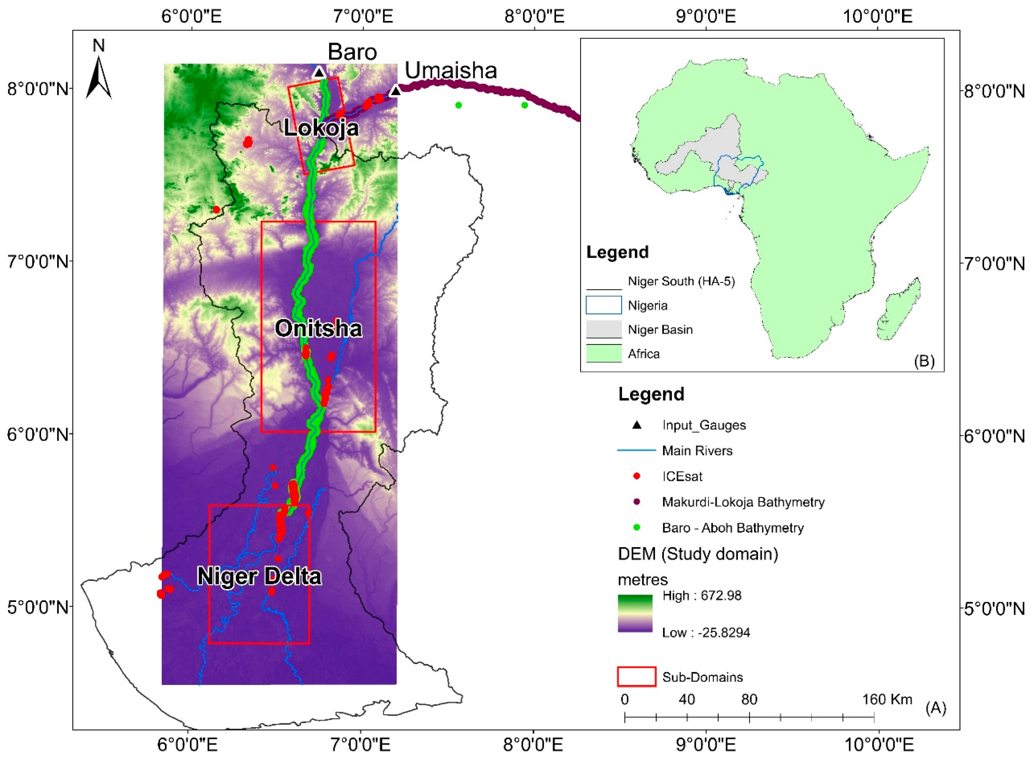
Study Area
2. Materials and Methods
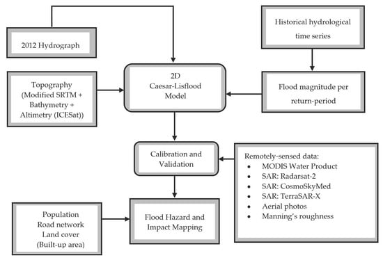
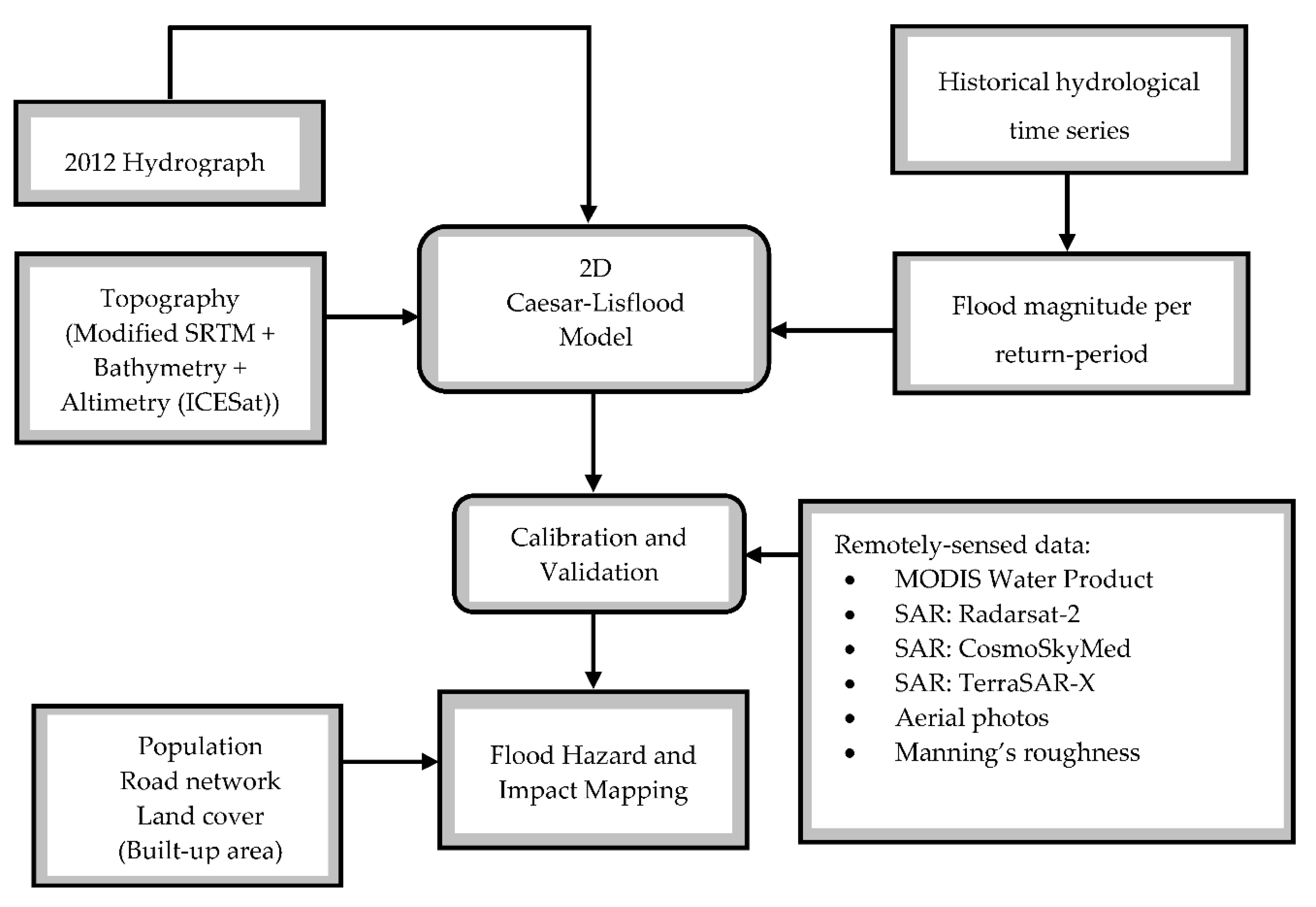
2.1. Methodological Framework
2.2. Datasets
2.2.1. River Discharge and Flood Frequency Estimates
2.2.2. Modified Shuttle Radar Topography Mission (SRTM) DEM
2.2.3. River Bathymetry
2.2.4. Moderate Resolution Imaging Spectroradiometer (MODIS) Water Product (MWP)
2.2.5. Synthetic Aperture Radar (SAR)
2.2.6. Ice, Cloud, and Land Elevation Satellite (ICESat)/Geoscience Laser Altimeter System (GLAS) spot height
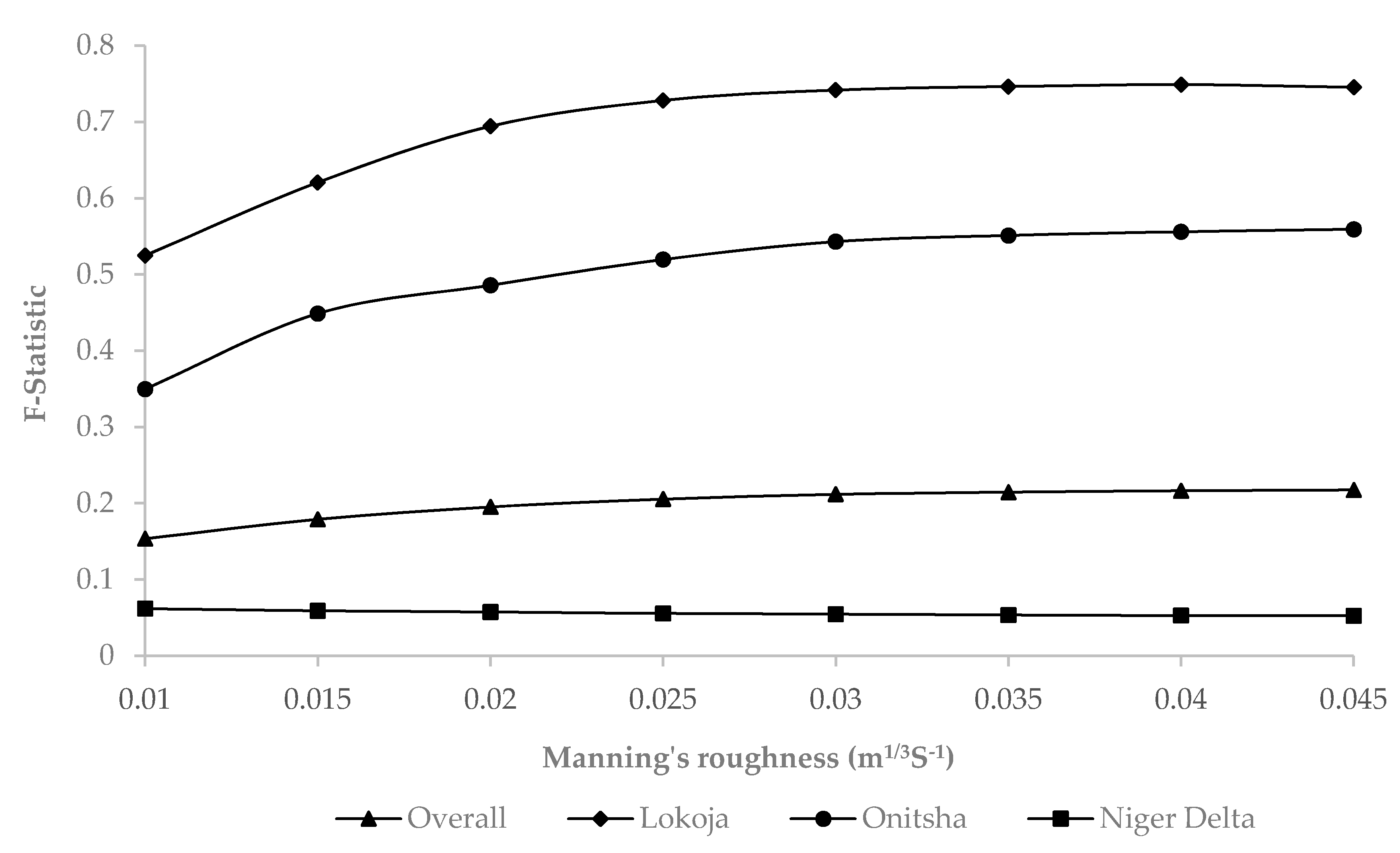
2.2.7. Manning’s Roughness
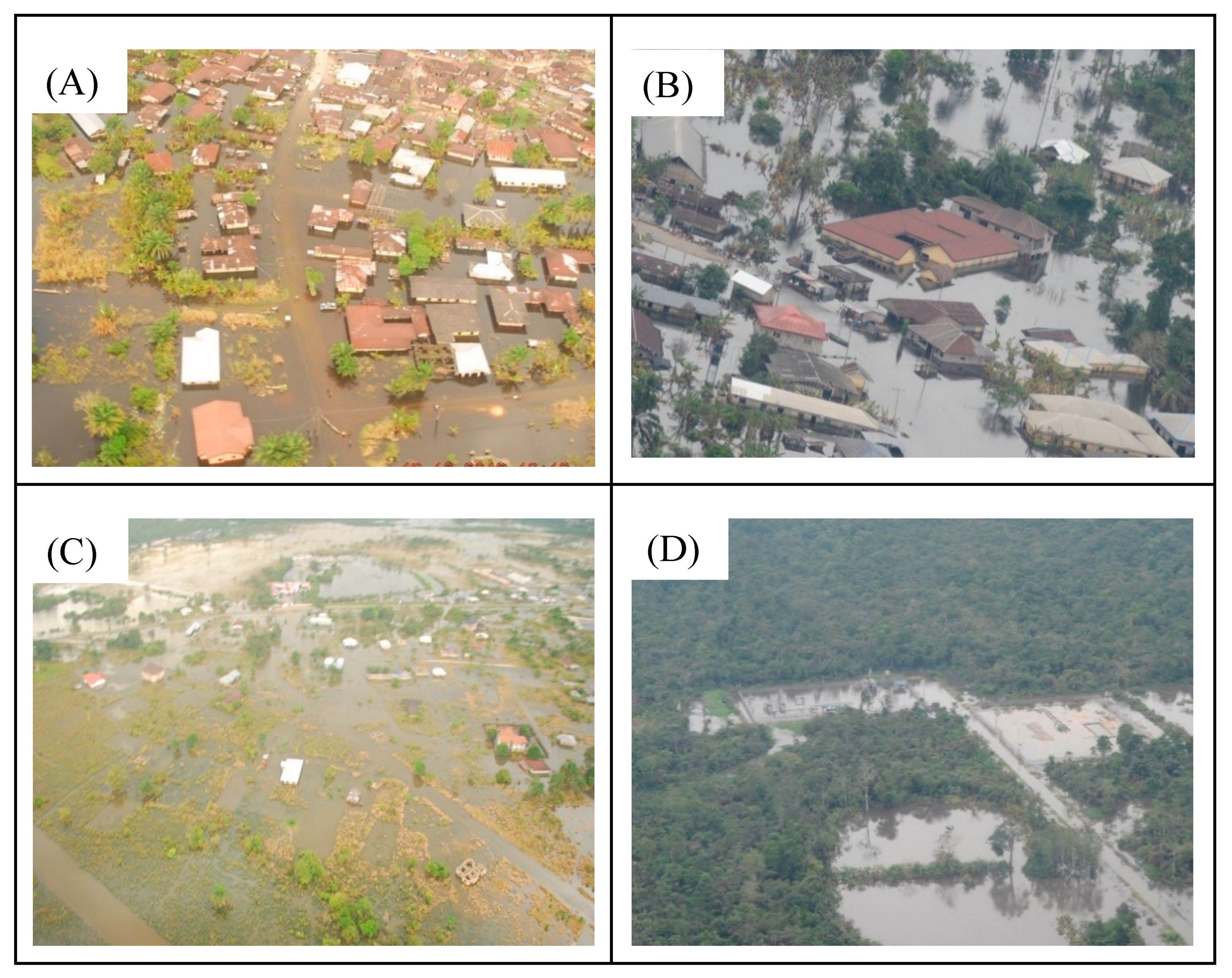
2.2.8. Aerial Photos
2.2.9. Data for Flood Impact Evaluation
2.3. Caesar-Lisflood (CL) Hydrodynamic Model Description and Setup
2.4. Model Calibration and Validation
3. Results and Discussion
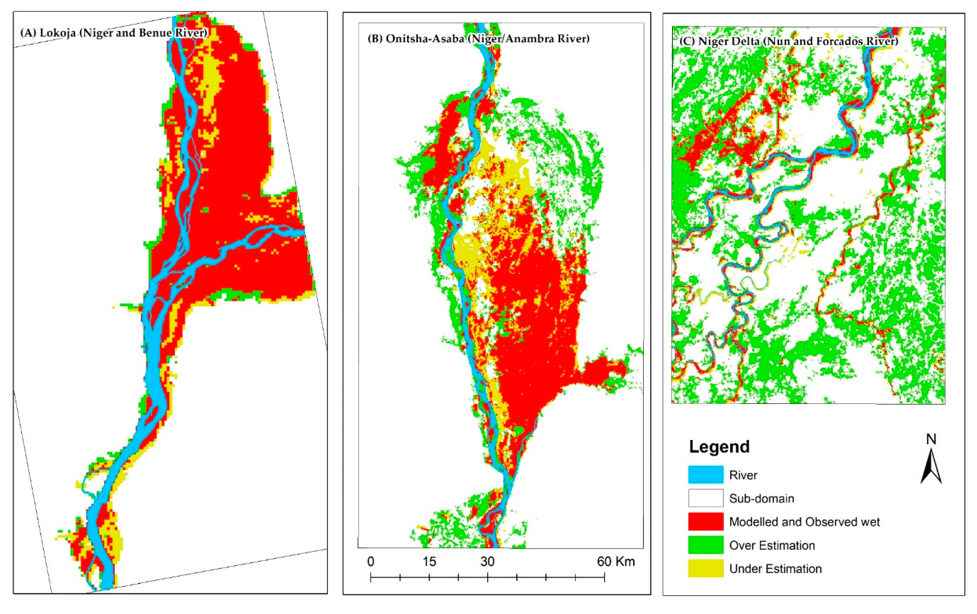
3.1. Integration of Open-Access Remote Sensing and Geospatial Data for Catchment-Scale Flood Modelling
3.2. Flood Model Re-Validation in Vegetation-Dominant Region Using Freely Available Aerial Photos and SAR
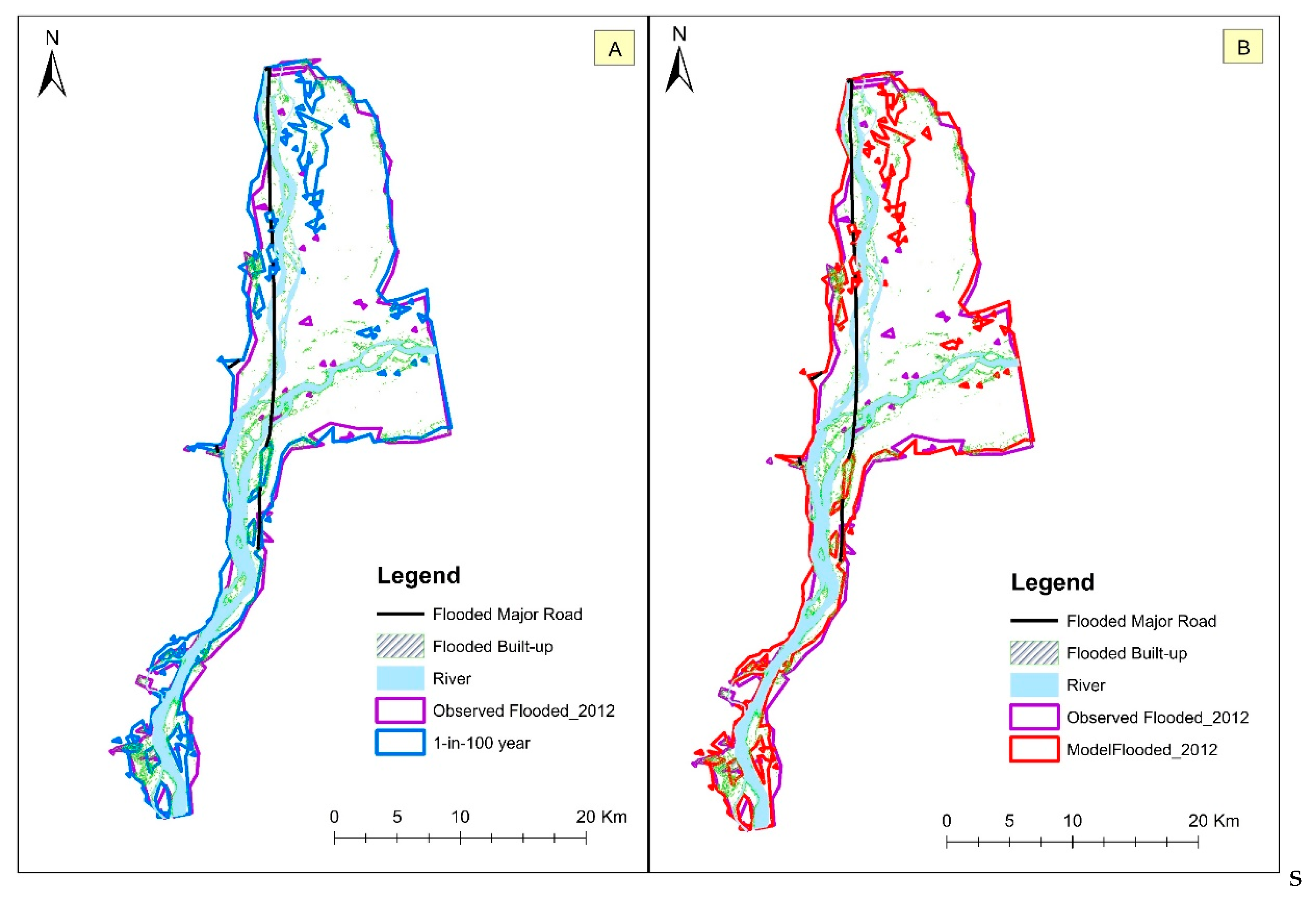
3.3. Quantifying the Magnitude and Impact of the 2012 Flood in Nigeria
4. Conclusions
Supplementary Materials
Author Contributions
Funding
Acknowledgments
Conflicts of Interest
References
- Balbus, J.M.; Boxall, A.B.A.; Fenske, R.A.; McKone, T.E.; Zeise, L. Implications of global climate change for the assessment and management of human health risks of chemicals in the natural environment. Environ. Toxicol. Chem. 2013, 32, 62–78. [Google Scholar] [CrossRef] [PubMed]
- Jongman, B.; Ward, P.J.; Aerts, J.C.J.H. Global exposure to river and coastal flooding: Long term trends and changes. Glob. Environ. Chang. 2012, 22, 823–835. [Google Scholar] [CrossRef]
- Yukiko, H.; Roobavannan, M.; Sujan, K.; Lisako, K.; Dai, Y.; Satoshi, W.; Hyungjun, K.; Shinjiro, K. Global flood risk under climate change. Nat. Clim. Chang. 2013, 3, 816–821. [Google Scholar] [CrossRef]
- Ekeu-wei, I.T.; Blackburn, G.A. Applications of open-access remotely sensed data for flood modelling and mapping in developing regions. Hydrology 2018, 5, 39. [Google Scholar] [CrossRef]
- Ojigi, M.; Abdulkadir, F.; Aderoju, M. Geospatial mapping and analysis of the 2012 flood disaster in central parts of Nigeria. In Proceedings of the 8th National GIS Symposium, Dammam, Saudi Arabia, 8 June 2013; pp. 1–14. [Google Scholar]
- The Federal Government of Nigeria. Post-Disaster Needs Assessment 2012 Floods; The Federal Government of Nigeria: Abuja, Nigeria, 2013.
- Els, Z. Data Availability and Requirements for Flood Hazard Mapping in South Africa. Master’s Thesis, Stellenbosch University, Stellenbosch, South Africa, 2013. [Google Scholar]
- Aerts, J.C.J.H.; van Alphen, J.; der Moel, H. Flood maps in Europe-methods, availability and use. Nat. Hazards Earth Syst. Sci. 2009, 9, 289–301. [Google Scholar]
- Robson, A.; Reed, D. Statistical procedures for flood frequency estimation. In Flood Estimation Handbook; Institute of Hydrology: Wallingford, UK, 1999; Volume 3. [Google Scholar]
- Rogger, M.; Kohl, B.; Pirkl, H.; Viglione, A.; Komma, J.; Kirnbauer, R.; Merz, R.; Blöschl, G. Runoff models and flood frequency statistics for design flood estimation in Austria—Do they tell a consistent story? J. Hydrol. 2012, 456–457, 30–43. [Google Scholar] [CrossRef]
- Pandey, R.; Amarnath, G. The potential of satellite radar altimetry in flood forecasting: Concept and implementation for the Niger-Benue river basin. Proc. IAHS 2015, 370, 223–227. [Google Scholar] [CrossRef]
- Haddad, K.; Rahman, A.; Ling, F. Regional flood frequency analysis method for Tasmania, Australia: A case study on the comparison of fixed region and region-of-influence approaches. Hydrol. Sci. J. 2014. [Google Scholar] [CrossRef]
- Skinner, C.J.; Coulthard, T.J.; Parsons, D.R.; Ramirez, J.A.; Mullen, L.; Manson, S. Simulating tidal and storm surge hydraulics with a simple 2D inertia based model, in the Humber Estuary, U.K. Estuar. Coast. Shelf Sci. 2015, 155, 126–136. [Google Scholar] [CrossRef]
- Kron, W. Flood risk= hazard• values• vulnerability. Water Int. 2005, 30, 58–68. [Google Scholar] [CrossRef]
- Di Baldassarre, G.; Schumann, G.; Bates, P.D.; Freer, J.E.; Beven, K.J. Flood-plain mapping: A critical discussion of deterministic and probabilistic approaches. Hydrol. Sci. J. 2010, 55, 364–376. [Google Scholar] [CrossRef]
- Domeneghetti, A.; Vorogushyn, S.; Castellarin, A.; Merz, B.; Brath, A. Probabilistic flood hazard mapping: Effects of uncertain boundary conditions. Hydrol. Earth Syst. Sci. 2013, 17, 3127–3140. [Google Scholar] [CrossRef]
- Bshir, D.; Garba, M. Hydrological monitoring and information system for sustainable basin management. In Proceedings of the First Annual Conference of the Nigerian Association of Hydrological Sciences, Federal University of Technology, Yola, Adamawa, Nigeria, 2–4 December 2003. [Google Scholar]
- Ngene, B.U. Optimization of Rain Gauge Stations in Nigeria. Ph.D. Thesis, Federal University of Technology, Owerri, Nigeria, 2009. [Google Scholar]
- Ekeu-wei, I.T. Evaluation of Hydrological Data Collection Challenges and Flood Estimation Uncertainties in Nigeria. Environ. Nat. Resour. Res. 2018, 8, 44–54. [Google Scholar] [CrossRef]
- Olayinka, D.N.; Nwilo, P.C.; Emmanuel, A. From Catchment to Reach: Predictive Modelling of Floods in Nigeria. In Proceedings of the FIG Working Week, Environment for Sustainability, Abuja, Nigeria, 6–10 May 2013. [Google Scholar]
- Ngene, B.U.; Agunwamba, J.C.; Nwachukwu, B.A.; Okoro, B.C. The challenges to Nigerian rain gauge network improvement. RJEES 2015, 7, 68–74. [Google Scholar] [CrossRef]
- Yan, K.; Di Baldassarre, G.; Solomatine, D.P.; Schumann, G.J.P. A review of low-cost space-borne data for flood modelling: Topography, flood extent and water level. Hydrol. Process. 2015, 29, 3368–3387. [Google Scholar] [CrossRef]
- Sanyal, J.; Carbonneau, P.; Densmore, A. Hydraulic routing of extreme floods in a large ungauged river and the estimation of associated uncertainties: A case study of the Damodar River, India. Nat. Hazards 2013, 66, 1153–1177. [Google Scholar] [CrossRef]
- Musa, Z.; Popescu, I.; Mynett, A. A review of applications of satellite SAR, optical, altimetry and DEM data for surface water modelling, mapping and parameter estimation. Hydrol. Earth Syst. Sci. Dis. 2015, 12, 4857–4878. [Google Scholar] [CrossRef]
- Yan, K.; Tarpanelli, A.; Balint, G.; Moramarco, T.; Baldassarre, G.D. Exploring the potential of SRTM topography and radar altimetry to support flood propagation modeling: Danube case study. J. Hydrol. Eng. 2015, 20, 04014048. [Google Scholar] [CrossRef]
- Stephens, E.; Schumann, G.; Bates, P. Problems with binary pattern measures for flood model evaluation. Hydrol. Process. 2014, 28, 4928–4937. [Google Scholar] [CrossRef]
- Mason, D.C.; Schumann, G.; Bates, P. Data Utilization in Flood Inundation Modelling; Blackwell Publishing Ltd.: Oxford, UK, 2011; pp. 209–233. [Google Scholar]
- Uchegbulam, O.; Ayolabi, E. Satellite image analysis using remote sensing data in parts of Western Niger Delta, Nigeria. J. Emerg. Trends Eng. Appl. Sci. 2013, 4, 612–617. [Google Scholar]
- Musa, Z.N.; Popescu, I.I.; Munett, A. Sensitivity analysis of the 2D SOBEK hydrodynamic model of the Niger River. In Proceedings of the 36th IAHR World Congress, The Hague, The Netherlands, 28 June–3 July 2015. [Google Scholar]
- Shustikova, I.; Domeneghetti, A.; Neal, J.C.; Bates, P.; Castellarin, A. Comparing 2D capabilities of HEC-RAS and LISFLOOD-FP on complex topography. Hydrol. Sci. J. 2019, 64, 1769–1782. [Google Scholar] [CrossRef]
- Gaston, L. Integrated future needs and climate change on the River Niger water availability. J. Water Resour. Prot. 2013, 5, 887–893. [Google Scholar]
- Abam, T. Regional hydrological research perspectives in the Niger Delta. Hydrol. Sci. J. 2001, 46, 13–25. [Google Scholar] [CrossRef]
- Aich, V.; Koné, B.; Hattermann, F.F.; Müller, E.N. Floods in the Niger basin—Analysis and attribution. Nat. Hazards Earth Syst. Sci. Dis. 2014, 2, 5171–5212. [Google Scholar] [CrossRef]
- Andersen, I.; Golitzen, K.G. The Niger River Basin: A Vision for Sustainable Management; World Bank Publications: Washington, DC, USA, 2005. [Google Scholar]
- Olojo, O.O.; Asma, T.I.; Isah, A.A.; Oyewumi, A.S.; Adepero, O. The role of earth observation satellite during the international collaboration on the 2012 Nigeria flood disaster. In Proceedings of the 64th International Astronautical Congress, Beijing, China, 23–27 September 2013. [Google Scholar]
- Agada, S.; Nirupama, N. A serious flooding event in Nigeria in 2012 with specific focus on Benue State: A brief review. Nat. Hazards 2015, 77, 1405–1414. [Google Scholar] [CrossRef]
- Odunuga, S.; Adegun, O.; Raji, S.; Udofia, S. Changes in flood risk in lower Niger-Benue catchments. Proc. Int. Assoc. Hydrol. Sci. 2015, 370, 97–102. [Google Scholar] [CrossRef]
- Efobi, K.; Anierobi, C. Urban flooding and vulnerability of Nigerian cities: A case study of Awka and Onitsha in Anambra State, Nigeria. J. Law Policy Glob. 2013, 19, 58–64. [Google Scholar]
- Ekeu-wei, I.T. Application of Open-Access and 3rd Party Geospatial Technology for Integrated Flood Risk Management in Data Sparse Regions of Developing Countries; Lancaster University: Lancaster, UK, 2018. [Google Scholar]
- O’Loughlin, F.; Paiva, R.; Durand, M.; Alsdorf, D.; Bates, P. Development of a ‘bare-earth’ SRTM DEM product. In Proceedings of the EGU General Assembly Conference Abstracts, Vienna, Austria, 12–17 April 2015; p. 9651. [Google Scholar]
- Sampson, C.C.; Smith, A.M.; Bates, P.D.; Neal, J.C.; Alfieri, L.; Freer, J.E. A high-resolution global flood hazard model. Water Resour. Res. 2015, 51, 7358–7381. [Google Scholar] [CrossRef]
- O’Loughlin, F.E.; Neal, J.; Yamazaki, D.; Bates, P.D. ICESat-derived inland water surface spot heights. Water Resour. Res. 2016, 52, 3276–3284. [Google Scholar] [CrossRef]
- Sibson, R. A brief description of natural neighbour interpolation. In Interpreting Multivariate Data; Wiley: New York, NY, USA, 1981; Volume 21, pp. 21–36. [Google Scholar]
- Neal, J.; Schumann, G.; Bates, P. A subgrid channel model for simulating river hydraulics and floodplain inundation over large and data sparse areas. Water Resour. Res. 2012, 48, W11506. [Google Scholar] [CrossRef]
- Nigro, J.; Slayback, D.; Policelli, F.; Brakenridge, G. NASA/DFO MODIS near real-time (NRT) global flood mapping product evaluation of flood and permanent water detection. Evaluation 2014, 1–27. [Google Scholar]
- Revilla-Romero, B.; Hirpa, F.A.; Thielen-Del Pozo, J.; Salamon, P.; Brakenridge, R.; Pappenberger, F.; De Groeve, T. On the use of global flood forecasts and satellite- derived inundation maps for flood monitoring in data-sparse regions. Remote Sens. 2015, 7, 15702–15728. [Google Scholar] [CrossRef]
- Jong-Sen, L. A simple speckle smoothing algorithm for synthetic aperture radar images. IEEE Trans. Syst. Man Cybern. 1983, SMC-13, 85–89. [Google Scholar] [CrossRef]
- Patro, S.; Chatterjee, C.; Singh, R.; Raghuwanshi, N. Hydrodynamic modelling of a large flood-prone river system in India with limited data. Hydrol. Process. 2009, 23, 2774–2791. [Google Scholar] [CrossRef]
- Chow, V. Open Channel Hydraulics; McGraw-Hill: New York, NY, USA, 1959. [Google Scholar]
- Arcement, G.J.; Schneider, V.R. Guide for Selecting Manning’s Roughness Coefficients for Natural Channels and Flood Plains; US Government Printing Office: Washington, DC, USA, 1989.
- Seenath, A. Modelling coastal flood vulnerability: Does spatially-distributed friction improve the prediction of flood extent? Appl. Geogr. 2015, 64, 97–107. [Google Scholar] [CrossRef]
- Olayinka, D.N. Modelling Flooding in the Niger Delta. Ph.D. Thesis, Lancaster University, Lancaster, UK, 2012. [Google Scholar]
- Hamrouni, A.; Ghazzai, H.; Frikha, M.; Massoud, Y. A photo-based mobile crowdsourcing framework for event reporting. In Proceedings of the 2019 IEEE 62nd International Midwest Symposium on Circuits and Systems (MWSCAS), Dallas, TX, USA, 4–7 August 2019; pp. 198–202. [Google Scholar]
- Yu, D.; Yin, J.; Liu, M. Validating city-scale surface water flood modelling using crowd-sourced data. Environ. Res. Lett. 2016, 11, 124011. [Google Scholar] [CrossRef]
- Ciesin, S. Gridded Population of the World, Version 4 (GPWV4): Population Density; Technical Report; Center for International Earth Science Information Network: Palisades, NY, USA, 2016. [Google Scholar]
- Center for International Earth Science Information Network—Columbia University. Global Roads Open Access Data Set, Version 1 (gROADSv1); NASA Socioeconomic Data and Applications Center (SEDAC): Palisades, NY, USA, 2013.
- Butt, A.; Shabbir, R.; Ahmad, S.S.; Aziz, N. Land use change mapping and analysis using remote sensing and GIS: A case study of Simly watershed, Islamabad, Pakistan. Egypt. J. Remote Sens. Space Sci. 2015, 18, 215–259. [Google Scholar] [CrossRef]
- National Aeronautics and Space Administration (NASA) Near Real Time Global Flood Mapping. Available online: https://floodmap.modaps.eosdis.nasa.gov/ (accessed on 15 June 2018).
- Van De Wiel, M.J.; Coulthard, T.J.; Macklin, M.G.; Lewin, J. Embedding reach-scale fluvial dynamics within the CAESAR cellular automaton landscape evolution model. Geomorphology 2007, 90, 283–301. [Google Scholar] [CrossRef]
- Bates, P.D.; Horritt, M.S.; Fewtrell, T.J. A simple inertial formulation of the shallow water equations for efficient two-dimensional flood inundation modelling. J. Hydrol. 2010, 387, 33–45. [Google Scholar] [CrossRef]
- Trigg, M.A.; Bates, P.D.; Wilson, M.D.; Horritt, M.S.; Alsdorf, D.E.; Forsberg, B.R.; Vega, M.C. Amazon flood wave hydraulics. J. Hydrol. 2009, 374, 92–105. [Google Scholar] [CrossRef]
- Almeida, G.A.M.; Bates, P.; Freer, J.E.; Souvignet, M. Improving the stability of a simple formulation of the shallow water equations for 2-D flood modeling. Water Resour. Res. 2012, 48. [Google Scholar] [CrossRef]
- Coulthard, T.J.; Neal, J.C.; Bates, P.D.; Ramirez, J.; de Almeida, G.A.M.; Hancock, G.R. Integrating the LISFLOOD-FP 2D hydrodynamic model with the CAESAR model: Implications for modelling landscape evolution. Earth Surf. Process. Landf. 2013, 38, 1897–1906. [Google Scholar] [CrossRef]
- Neal, J.; Schumann, G.; Fewtrell, T.; Budimir, M.; Bates, P.; Mason, D. Evaluating a new LISFLOOD-FP formulation with data from the summer 2007 floods in Tewkesbury, UK. J. Flood Risk Manag. 2011, 4, 88–95. [Google Scholar] [CrossRef]
- Di Baldassarre, G. Floods in a Changing Climate [Electronic Resource]: Inundation Modelling; Cambridge University Press: Cambridge, UK, 2012. [Google Scholar]
- Tong, X.; Luo, X.; Liu, S.; Xie, H.; Chao, W.; Liu, S.; Liu, S.; Makhinov, A.; Makhinova, A.; Jiang, Y. An approach for flood monitoring by the combined use of Landsat 8 optical imagery and COSMO-SkyMed radar imagery. ISPRS J. Photogramm. Remote Sens. 2018, 136, 144–153. [Google Scholar] [CrossRef]
- Long, S.; Fatoyinbo, T.E.; Policelli, F. Flood extent mapping for namibia using change detection and thresholding with SAR. Environ. Res. Lett. 2014, 9, 035002. [Google Scholar] [CrossRef]
- Jung, Y.; Merwade, V. Estimation of uncertainty propagation in flood inundation mapping using a 1-D hydraulic model. Hydrol. Process. 2015, 29, 624–640. [Google Scholar] [CrossRef]
- Cook, A.; Merwade, V. Effect of topographic data, geometric configuration and modeling approach on flood inundation mapping. J. Hydrol. 2009, 377, 131–142. [Google Scholar] [CrossRef]
- Jarihani, A.A.; Callow, J.N.; McVicar, T.R.; Van Niel, T.G.; Larsen, J.R. Satellite-derived Digital Elevation Model (DEM) selection, preparation and correction for hydrodynamic modelling in large, low-gradient and data-sparse catchments. J. Hydrol. 2015, 524, 489–506. [Google Scholar] [CrossRef]
- Casas, A.; Benito, G.; Thorndycraft, V.R.; Rico, M. The topographic data source of digital terrain models as a key element in the accuracy of hydraulic flood modelling. Earth Surface Process. Landf. 2006, 31, 444–456. [Google Scholar] [CrossRef]
- Van Der Burg, T. Dredging for Development on the Lower River Niger between Baro and Warri, Nigeria. Terra Aqua 2010, 21, 27–30. [Google Scholar]
- Md Ali, A.; Solomatine, D.P.; Md Ali, G.; Solomatine, G.; Di Baldassarre, G. Assessing the impact of different sources of topographic data on 1- D hydraulic modelling of floods. Hydrol. Earth Syst. Sci. 2015, 19, 631–643. [Google Scholar] [CrossRef]
- Domeneghetti, A.; Tarpanelli, A.; Brocca, L.; Barbetta, S.; Moramarco, T.; Castellarin, A.; Brath, A. The use of remote sensing—derived water surface data for hydraulic model calibration. Remote Sens. Environ. 2014, 149, 130–141. [Google Scholar] [CrossRef]
- Trigg, M.; Birch, C.; Neal, J.; Bates, P.; Smith, A.; Sampson, C.; Yamazaki, D.; Hirabayashi, Y.; Pappenberger, F.; Dutra, E. The credibility challenge for global fluvial flood risk analysis. Environ. Res. Lett. 2016, 11, 094014. [Google Scholar] [CrossRef]
- Bernhofen, M.V.; Whyman, C.; Trigg, M.A.; Sleigh, A.; Smith, A.M.; Sampson, C.C.; Yamazaki, D.; Wars, P.J.; Rudari, R.; Pappenberger, F.; et al. A first collective validation of global fluvial flood models for major floods in Nigeria and Mozambique. Environ. Res. Lett. 2018, 13, 104007. [Google Scholar] [CrossRef]
- Dottori, F.; Salamon, P.; Bianchi, A.; Alfieri, L.; Hirpa, F.A.; Feyen, L. Development and evaluation of a framework for global flood hazard mapping. Adv. Water Resour. 2016, 94, 87–102. [Google Scholar] [CrossRef]
- Fleischmann, A.; Paiva, R.; Collischonn, W. Can regional to continental river hydrodynamic models be locally relevant? A cross-scale comparison. J. Hydrol. 2019. [Google Scholar] [CrossRef]
- Gessese, A.; Wa, K.M.; Sellier, M. Bathymetry reconstruction based on the zero-inertia shallow water approximation. Theor. Comput. Fluid Dyn. 2013, 27, 721–732. [Google Scholar] [CrossRef]
- Sanyal, J.; Densmore, A.L.; Carbonneau, P. Analysing the effect of land-use/cover changes at sub-catchment levels on downstream flood peaks: A semi-distributed modelling approach with sparse data. Catena 2014, 118, 28–40. [Google Scholar] [CrossRef]
- O’Loughlin, F.E.; Paiva, R.C.D.; Durand, M.; Alsdorf, D.E.; Bates, P.D. A multi- sensor approach towards a global vegetation corrected SRTM DEM product. Remote Sens. Environ. 2016, 182, 49–59. [Google Scholar] [CrossRef]
- Baugh, C.A.; Bates, P.D.; Schumann, G.; Trigg, M.A. SRTM vegetation removal and hydrodynamic modeling accuracy. Water Resour. Res. 2013, 49, 5276–5289. [Google Scholar] [CrossRef]
- Federal Ministry of Environment. Technical Guidelines on Soil Erosion, Flood and Coastal Zone Management; IFPR: Abuja, Nigeria, 2005. [Google Scholar]
- Biancamaria, S.; Hossain, F.; Lettenmaier, D.P. Forecasting transboundary river water elevations from space. Geophys. Res. Lett. 2011, 38. [Google Scholar] [CrossRef]

| Dates [YYYY-MM-DD] | Images and Availability | Baro (m3/s) | Return Period (1-in-year) | Umaisha (m3/s) | Return Period (1-in-year) | |||
|---|---|---|---|---|---|---|---|---|
| TSX | MDS | R2 | CSKD | |||||
| 2012-09-03 | × | √ | √ | × | 5187 | 2 | 12,303 | 2 |
| 2012-09-25 | √ | √ | × | × | 8533 | 50 | 20,328 | 100 |
| 2012-10-09 | × | √ | √ | × | 6969 | 5 | 17,378 | 50 |
| 2012-10-11 | × | √ | √ | × | 6696 | 5 | 16,771 | 20 |
| 2012-10-12 | × | √ | √ | × | 6504 | 5 | 16,520 | 20 |
| 2012-11-06 | × | √ | √ | √ | 3270 | 2 | 7955 | 2 |
| Spatial Data | Data Source | Sub-Domains | ||
|---|---|---|---|---|
| Lokoja | Onitsha | Niger Delta | ||
| MODIS Water Product | Nigro [45]; NASA [58] | √ | √ | × |
| SAR: TerraSAR-X | ICSD | √ | × | × |
| SAR: Radarsat-2 | Ekeu-wei [39]; SPDC | × | × | √ |
| SAR: Cosmo-SkyMed | Ekeu-wei [39]; SPDC | × | × | √ |
| Aerial photos | Ekeu-wei [39]; SPDC | × | × | √ |
| River Bathymetry | Royal Haskoning; Digital Horizon | √ | √ | × |
| ICESat | O’Loughlin et al., [42] | √ | √ | √ |
| Modified SRTM DEM | O’Loughlin et al. [40], Sampson et al. [41] | √ | √ | √ |
| Performance | Overall | Lokoja | Onitsha | Niger Delta |
|---|---|---|---|---|
| F | 0.235 | 0.729 | 0.534 | 0.095 |
| Bias | 4.245 | 1.183 | 1.140 | 9.661 |
| % Flood Capture | 99.972 | 92.012 | 74.545 | 92.186 |
| Performance | Overall | Lokoja | Onitsha | Niger Delta |
|---|---|---|---|---|
| F | 0.273 | 0.808 | 0.529 | 0.187 |
| Bias | 2.511 | 0.918 | 1.132 | 3.432 |
| % Flood Capture | 75.308 | 85.679 | 73.802 | 69.946 |
| Points of Focus | Data Points (n = 287) | Hits | Miss | % Accuracy |
|---|---|---|---|---|
| A | Aerial photo and model flooded | 196 | 91 | 69 |
| B | Aerial photo and SAR flooded | 37 | 250 | 13 |
| C | Aerial photo, model and SAR flooded | 43 | 244 | 15 |
| D | The aerial photo only flooded | 62 | - | - |
| Flood | Area (km2) | Population | Built-up (km2) | Roads (km) |
|---|---|---|---|---|
| 2012 Model | 425.8 | 32,703 | 12.648 | 34.573 |
| 1-in-100 year Modelled | 427.2 | 32,867 | 12.834 | 32.987 |
| 2012 Observed (Satellite) | 440.2 | 34,391 | 12.326 | 37.287 |
© 2020 by the authors. Licensee MDPI, Basel, Switzerland. This article is an open access article distributed under the terms and conditions of the Creative Commons Attribution (CC BY) license (http://creativecommons.org/licenses/by/4.0/).
Share and Cite
Ekeu-wei, I.T.; Blackburn, G.A. Catchment-Scale Flood Modelling in Data-Sparse Regions Using Open-Access Geospatial Technology. ISPRS Int. J. Geo-Inf. 2020, 9, 512. https://doi.org/10.3390/ijgi9090512
Ekeu-wei IT, Blackburn GA. Catchment-Scale Flood Modelling in Data-Sparse Regions Using Open-Access Geospatial Technology. ISPRS International Journal of Geo-Information. 2020; 9(9):512. https://doi.org/10.3390/ijgi9090512
Chicago/Turabian StyleEkeu-wei, Iguniwari Thomas, and George Alan Blackburn. 2020. "Catchment-Scale Flood Modelling in Data-Sparse Regions Using Open-Access Geospatial Technology" ISPRS International Journal of Geo-Information 9, no. 9: 512. https://doi.org/10.3390/ijgi9090512
APA StyleEkeu-wei, I. T., & Blackburn, G. A. (2020). Catchment-Scale Flood Modelling in Data-Sparse Regions Using Open-Access Geospatial Technology. ISPRS International Journal of Geo-Information, 9(9), 512. https://doi.org/10.3390/ijgi9090512


