Wildfire Risk Assessment Based on Geospatial Open Data: Application on Chios, Greece


Abstract
:1. Introduction
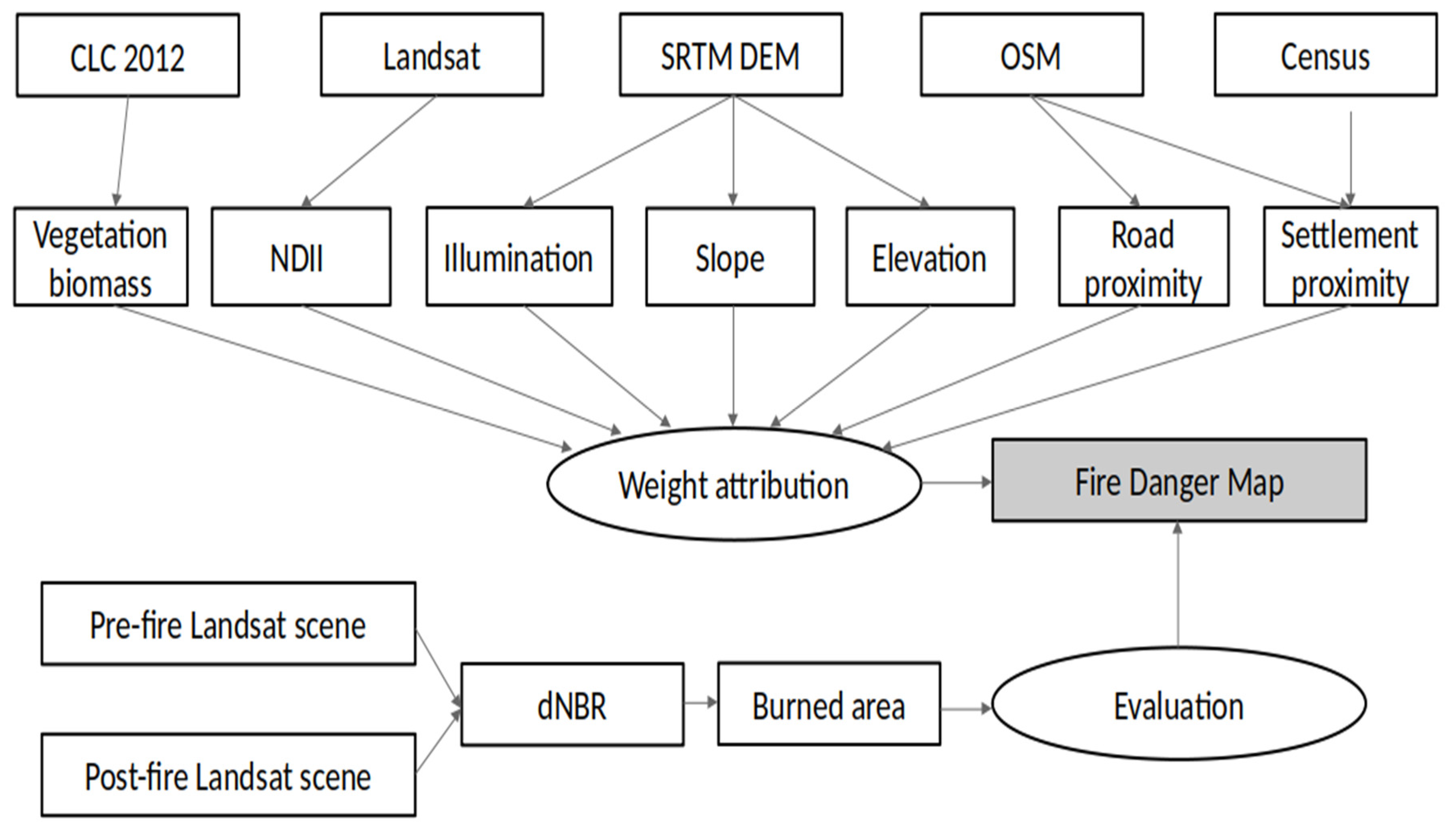
2. Materials and Methods
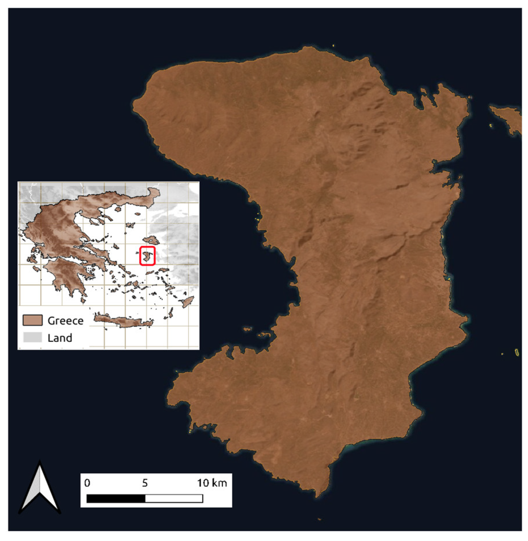
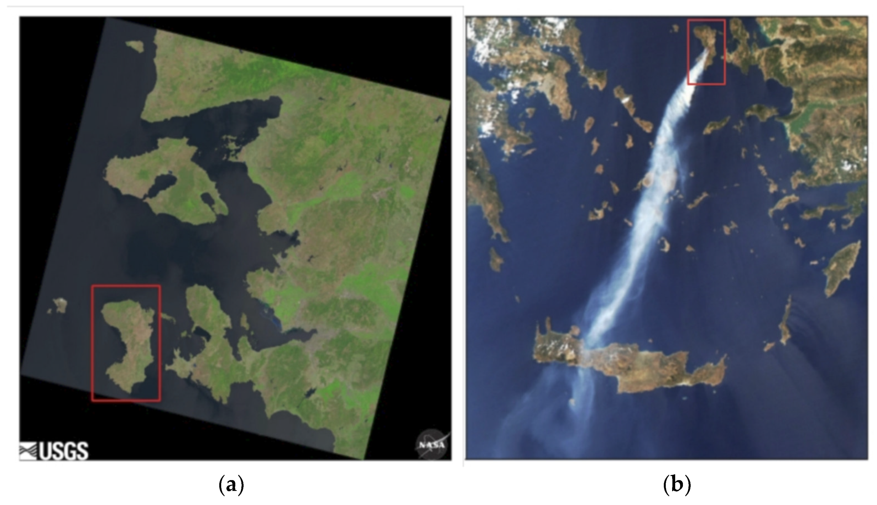
2.1. Study Area
2.2. Data
2.3. Methodology
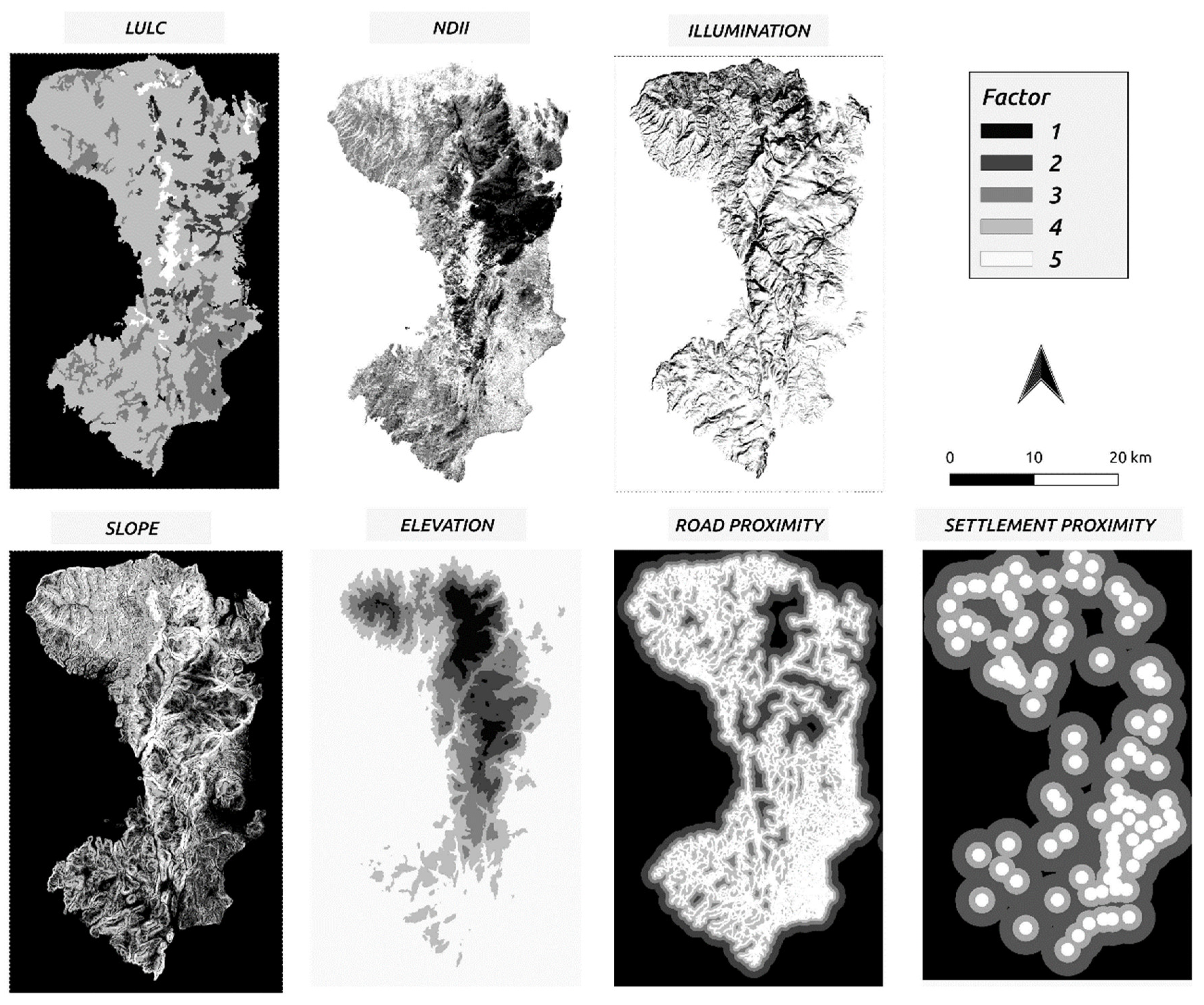
2.3.1. Vegetation—Land Use/Land Cover
2.3.2. NDII
2.3.3. Topography
2.3.4. Illumination
2.3.5. Human Factor—Proximity to Roads and Settlements
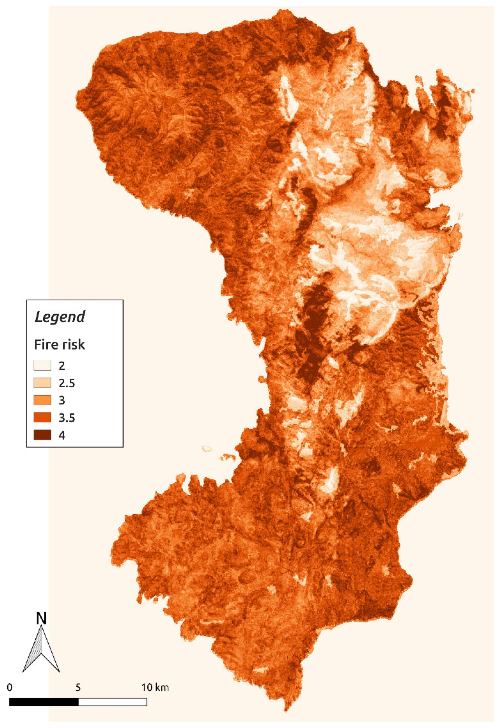
2.3.6. Risk Factor Weight Attribution
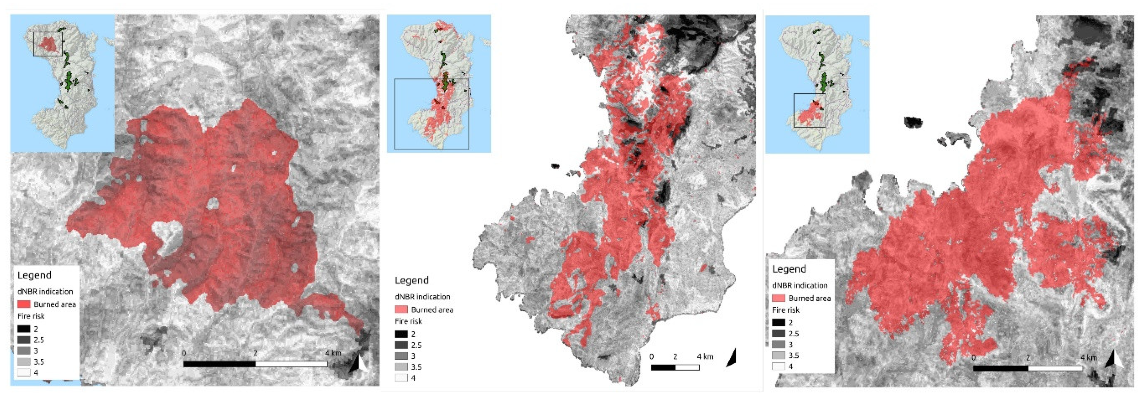
2.3.7. Burned Area Derivation
- ρλ′ = TOA Planetary Spectral Reflectance, without correction for solar angle (unitless)
- Mρ = Reflectance multiplicative scaling factor for the band.
- Aρ = Reflectance additive scaling factor for the band (which is different for each satellite).
- Qcal = L1 pixel value in DN
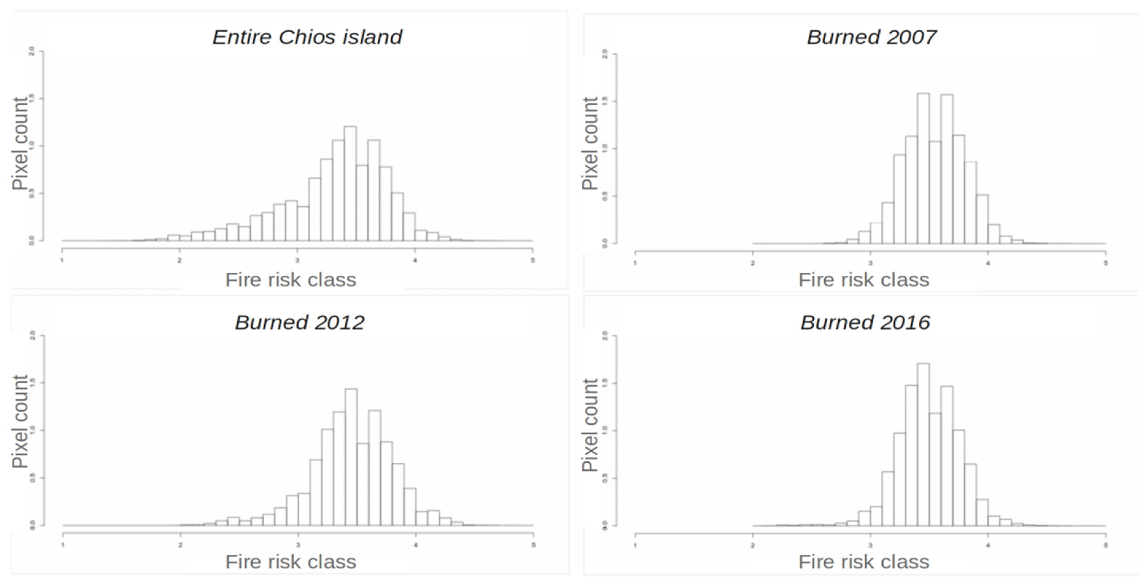
3. Results and Discussion
4. Conclusions
Supplementary Materials
Author Contributions
Funding
Acknowledgments
Conflicts of Interest
References
- FAO. Global Forest Resources Assessment 2005: Progress Towards Sustainable Forest Management; Food and Agriculture Organization of the United Nations: Rome, Italy, 2006.
- Houghton, R.A.; Ramakrishna, K. A review of national emissions inventories from select non-annex I countries: Implications for counting sources and sinks of carbon. Annu. Rev. Energy Environ. 1999, 24, 571–605. [Google Scholar] [CrossRef]
- Morancho, A.B. A hedonic valuation of urban green areas. Landsc. Urban. Plan. 2003, 66, 35–41. [Google Scholar] [CrossRef]
- Nuthammachot, N.; Phairuang, W.; Stratoulias, D. Estimation of carbon emission in the ex-mega rice project, indonesia based on sar satellite images. Appl. Ecol. Environ. Res. 2019, 17, 2489–2499. [Google Scholar] [CrossRef]
- Alexandrian, D.; Esnault, F.; Calabri, G. Forest fires in the Mediterranean area. In Proceedings of the FAO Meeting on Public Policies Affecting Forest Fires, Italy, Rome, 28–30 October 1998; pp. 28–30. [Google Scholar]
- Balch, J.K.; Bradley, B.A.; Abatzoglou, J.T.; Nagy, R.C.; Fusco, E.J.; Mahood, A.L. Human-started wildfires expand the fire niche across the United States. Proc. Natl. Acad. Sci. USA 2017, 114, 2946–2951. [Google Scholar] [CrossRef] [Green Version]
- Roy, P.S. Forest Fire and Degradation Assessment Using Satellite Remote Sensing and Geographic Information System. In Satellite Remote Sensing and GIS Applications in Agricultural Meteorology I; WMO: Geneva, Switzerland, 2003; Volume 361. [Google Scholar]
- Maheras, G. Forests fires in Greece. The Analysis of the Phenomenon Affecting both Natural Human Environment The Role of Sustainable Development in Controlling Fire Effects. Ph.D. Thesis, Lund University, Lund, Sweden, 2002. [Google Scholar]
- Rundel, P.; Arroyo, M.T.; Cowling, R.M.; Keeley, J.E.; Lamont, B.B.; Vargas, P. Mediterranean biomes: Evolution of their vegetation, floras, and climate. Annu. Rev. Ecol. Evol. Syst. 2016, 47, 383–407. [Google Scholar] [CrossRef]
- European Environment Agency. 2019. Available online: https://www.eea.europa.eu/data-and-maps/indicators/forest-fire-danger-3/assessment (accessed on 19 August 2020).
- Khabarov, N.; Krasovskii, A.; Obersteiner, M.; Swart, R.; Dosio, A.; San-Miguel-Ayanz, J.; Durrant, T.; Camia, A.; Migliavacca, M. Forest fires and adaptation options in Europe. Reg. Environ. Chang. 2014, 16, 21–30. [Google Scholar] [CrossRef] [Green Version]
- Vélez, R. High intensity forest fires in the Mediterranean basin: Natural and socio-economic causes. Disaster Manag. 1993, 5, 16–21. [Google Scholar]
- Dimitriou, A.; Mantakas, G.; Kouvelis, S. An Analysis of Key Issues that Underlie Forest Fires and Shape Subsequent Fire Management Strategies in 12 Countries in the Mediterranean Basin. In Final Report Prepared by Alcyon for WWF Mediterranean Programme Office and IUCN; WWF project 9Z0731.01; WWF: Gland, Switzerland, 2001. [Google Scholar]
- Birch, D.S.; Morgan, P.; Kolden, C.A.; Abatzoglou, J.T.; Dillon, G.K.; Hudak, A.T.; Smith, A.M.S. Vegetation, topography and daily weather influenced burn severity in central Idaho and western Montana forests. Ecosphere 2015, 6, art17. [Google Scholar] [CrossRef]
- Estes, B.L.; Knapp, E.E.; Skinner, C.N.; Miller, J.D.; Preisler, H.K. Factors influencing fire severity under moderate burning conditions in the Klamath Mountains, Northern California, USA. Ecosphere 2017, 8, e01794. [Google Scholar] [CrossRef] [Green Version]
- Dillon, G.K.; Holden, Z.A.; Morgan, P.; Crimmins, M.A.; Heyerdahl, E.K.; Luce, C.H. Both topography and climate affected forest and woodland burn severity in two regions of the western US, 1984 to 2006. Ecosphere 2011, 2, art130. [Google Scholar] [CrossRef]
- Fang, L.; Yang, J.; Zu, J.; Li, G.; Zhang, J. Quantifying influences and relative importance of fire weather, topography, and vegetation on fire size and fire severity in a Chinese boreal forest landscape. Ecol. Manag. 2015, 356, 2–12. [Google Scholar] [CrossRef]
- Viedma, O.; Quesada, J.; Torres, I.; De Santis, A.; Moreno, J.M. Fire severity in a large fire in a pinus pinaster forest is highly predictable from burning conditions, stand structure, and topography. Ecosystems 2014, 18, 237–250. [Google Scholar] [CrossRef]
- Hardy, C.C. Wildland fire hazard and risk: Problems, definitions, and context. Ecol. Manag. 2005, 211, 73–82. [Google Scholar] [CrossRef]
- Keane, R.E.; Drury, S.A.; Karau, E.C.; Hessburg, P.F.; Reynolds, K.M. A method for mapping fire hazard and risk across multiple scales and its application in fire management. Ecol. Model. 2010, 221, 2–18. [Google Scholar] [CrossRef]
- Chuvieco, E.; Aguado, I.; Yebra, M.; Nieto, H.; Salas, J.; Martín, M.P.; Vilar, L.; Martínez-Vega, J.; Martín, S.; Ibarra, P.; et al. Development of a framework for fire risk assessment using remote sensing and geographic information system technologies. Ecol. Model. 2010, 221, 46–58. [Google Scholar] [CrossRef]
- Chuvieco, E.; Deshayes, M.; Stach, N.; Cocero, D.; Riaño, D. Short-Term Fire Risk: Foliage Moisture Content Estimation from Satellite Data. In Remote Sensing of Large Wildfires; Springer: Berlin/Heidelberg, Germany, 1999; pp. 17–38. [Google Scholar]
- Marzano, R.; Bovio, G.; Guglielmet, E.; Jappiot, M.; Lampin, C.; Dauriac, F.; Deshayes, M.; Salas, J.; Aguado, I.; Martínez, J.; et al. Common Methods for Mapping the Wildland Fire Danger; EUFIRELAB: Euro-Mediterranean Wildland Fire Laboratory, a “wall-less” Laboratory for Wildland Fire Sciences and Technologies in the Euro-Mediterranean Region. Deliverable D-08-05; HAL Inrea: Bangalore, India, 2004. [Google Scholar]
- Lozano, F.J.; Suarez-Seoane, S.; Kelly, M.; Luis, E. A multi-scale approach for modeling fire occurrence probability using satellite data and classification trees: A case study in a mountainous Mediterranean region. Remote. Sens. Environ. 2008, 112, 708–719. [Google Scholar] [CrossRef]
- Chuvieco, E.; Salas, J. Mapping the spatial distribution of forest fire danger using GIS. Int. J. Geogr. Inf. Syst. 1996, 10, 333–345. [Google Scholar] [CrossRef]
- Jaiswal, R.K.; Mukherjee, S.; Raju, K.D.; Saxena, R. Forest fire risk zone mapping from satellite imagery and GIS. Int. J. Appl. Earth Obs. Geoinf. 2002, 4, 1–10. [Google Scholar] [CrossRef]
- Chuvieco, E.; Riaño, D.; Aguado, I.; Cocero, D. Estimation of fuel moisture content from multitemporal analysis of Landsat Thematic Mapper reflectance data: Applications in fire danger assessment. Int. J. Remote. Sens. 2002, 23, 2145–2162. [Google Scholar] [CrossRef]
- Viegas, D.X.; Bovio, G.; Ferreira, A.D.; Nosenzo, A.; Sol, B. Comparative study of various methods of fire danger evaluation in southern Europe. Int. J. Wildland Fire 1999, 9, 235–246. [Google Scholar] [CrossRef]
- Fang, L.; Yang, J.; White, M.; Liu, Z. Predicting potential fire severity using vegetation, topography and surface moisture availability in a eurasian boreal forest landscape. Forests 2018, 9, 130. [Google Scholar] [CrossRef] [Green Version]
- Yakubu, I.; Mireku-Gyimah, D.; Duker, A.A. Review of methods for modelling forest fire risk and hazard. Afr. J. Env. Sci. Technol. 2015, 9, 155–165. [Google Scholar] [CrossRef]
- Desbois, N.; Deshayes, M.; Beudoin, A. In Protocol for Fuel Moisture Content Measurements. A Review of Remote Rensing Methods for the Study of Large Wildland Fires; Chuvieco, E., Ed.; Universidad de Alcalá: Alcalá de Henares, Spain, 1997; pp. 61–72. [Google Scholar]
- Verbesselt, J.; Fleck, S.; Coppin, P. Estimation of fuel moisture content towards fire risk assessment: A review. For. Fire Res. Wildland Fire Saf. 2002, 55. [Google Scholar]
- Sriwongsitanon, N.; Gao, H.; Savenije, H.; Maekan, E.; Saengsawang, S.; Thianpopirug, S. Comparing the normalized difference infrared index (NDII) with root zone storage in a lumped conceptual model. Hydrol. Earth Syst. Sci. 2016, 20, 3361–3377. [Google Scholar] [CrossRef] [Green Version]
- Hardisky, M.; Klemas, V.; Smart, R.M. The influences of soil salinity, growth form, and leaf moisture on the spectral reflectance of spartina alterniflora canopies. Photogramm. Eng. Remote Sens. 1983, 49, 77–83. [Google Scholar]
- Sağlam, B.; Bilgili, E.; Durmaz, B.D.; Kadiogullari, A.I.; Kucuk, O. Spatio-temporal analysis of forest fire risk and danger using landsat imagery. Sensors 2008, 8, 3970–3987. [Google Scholar] [CrossRef] [PubMed] [Green Version]
- Setiawan, I.; Mahmud, A.; Mansor, S.; Shariff, A.; Nuruddin, A. GIS-grid-based and multi-criteria analysis for identifying and mapping peat swamp forest fire hazard in Pahang, Malaysia. Disaster Prev. Manag. Int. J. 2004, 13, 379–386. [Google Scholar] [CrossRef]
- Darmawan, M.; Masamu, A.; Satoshi, T. Forest fire hazard model using remote sensing and geographic information systems: Toward understanding of land and forest degradation in lowland areas of East Kalimantan, Indonesia. In Proceedings of the 22nd Asian Conference on Remote Sensing, Singapore, 5–9 November 2001. [Google Scholar]
- Sowmya, S.V.; Somashekar, R.K. Application of remote sensing and geographical information system in mapping forest fire risk zone at Bhadra wildlife sanctuary, India. J. Environ. Boil. 2010, 31, 969. [Google Scholar]
- Ajin, R.; Jacob, M.; Menon, A.; Vinod, P. Forest Fire Risk Analysis Using Geo-Information Technology: A Study of Peppara Wildlife Sanctuary, Thiruvananthapuram, Kerala, India. In Proceedings of the 2nd Disaster, Risk and Vulnerability Conference, Trivandrum, India, 24–26 April 2014. [Google Scholar]
- Vinod, P.G.; Ajin, R.S.; Jacob, M.K. RS and GIS based spatial mapping of forest fires in Wayanad wildlife sanctuary, Wayanad, North Kerala, India. Int. J. Earth Sci. Eng. 2016, 9, 498–502. [Google Scholar]
- Nuthammachot, N.; Stratoulias, D. A GIS- and AHP-based approach to map fire risk: A case study of Kuan Kreng peat swamp forest, Thailand. Geocarto Int. 2019, 1–14. [Google Scholar] [CrossRef]
- Adaktylou, N.E.; Stratoulias, D. A GIS Multi-criteria approach for forest fire risk assessment: A case study for chios, Greece. In Proceedings of the AGU Fall Meeting, Washington, DC, USA, 10–14 December 2018. [Google Scholar]
- Wirawan, N. Factors Promoting the Spread of Fire. 2000. Available online: http://www.nzdl.org/gsdlmod?e=d-00000-00---off-0hdl--00-0----0-10-0---0---0direct-10---4-------0-0l--11-en-50---20-help---00-0-1-00-0-0-11-1-0utfZz-8-00-0-0-11-10-0utfZz-8-10&cl=CL1.16&d=HASH40ec50fb1eb727e72e746a.8.7.4>=1 (accessed on 19 August 2020).
- Mansor, S.; Abu Shariah, M.; Billa, L.; Setiawan, I.; Jabar, F. Spatial technology for natural risk management. Disaster Prev. Manag. Int. J. 2004, 13, 364–373. [Google Scholar] [CrossRef]
- Chuvieco, E.; Congalton, R.G. Application of remote sensing and geographic information systems to forest fire hazard mapping. Remote. Sens. Environ. 1989, 29, 147–159. [Google Scholar] [CrossRef]
- Jo, M.H. The development of forest fire forecasting system using internet GIS and satellite remote sensing. In Proceedings of the 21st Asian Conference on Remote Sensing, Singapore, 5–9 November 2001. [Google Scholar]
- Ierapetritis, D. The Geography of the chios mastic trade from the 17th through to the 19th century. Ethnobot. Res. Appl. 2010, 8, 153–167. [Google Scholar] [CrossRef] [Green Version]
- Abraham, E.; Kyriazopoulos, A.; Korakis, G.; Parissi, Z.; Chouvardas, D. Wild fire effects on floristic diversity in three thermo-mediterranean vegetation types in a small islet of eastern Aegean sea. In Proceedings of the EGU General Assembly, Vienna, Austria, 27 April–2 May 2014. [Google Scholar]
- European Commission NATURA 2000. 2008. Available online: http://ec.europa.eu/environment/nature/natura2000/index_en.htm (accessed on 19 August 2020).
- Keeley, J.E. Fire in Mediterranean climate ecosystems—A comparative overview. Isr. J. Ecol. Evol. 2012, 58, 123–135. [Google Scholar]
- Turco, M.; Rosa-Cánovas, J.J.; Bedia, J.; Jerez, S.; Montávez, J.P.; Llasat, M.C.; Provenzale, A. Exacerbated fires in Mediterranean Europe due to anthropogenic warming projected with non-stationary climate-fire models. Nat. Commun. 2018, 9, 3821. [Google Scholar] [CrossRef]
- UCAR/NCAR. Wildfires, Weather & Climate. 2010. Available online: https://news.ucar.edu/1437/wildfires-weather-climate (accessed on 19 August 2020).
- Hellenic Statistical Authority. Population-Housing Census. 2011. Available online: http://www.statistics.gr/en/2011-census-pop-hous (accessed on 28 February 2019).
- Keeley, J.E.; Bond, W.J.; Bradstock, R.A.; Pausas, J.G.; Rundel, P.W. Fire in Mediterranean Ecosystems; Cambridge University Press (CUP): Cambridge, UK, 2011. [Google Scholar]
- Wright, J.; Lillesand, T.M.; Kiefer, R.W. Remote sensing and image interpretation. Geogr. J. 1980, 146, 448. [Google Scholar] [CrossRef]
- Knight, J.; Gerbig, J.; Whitman, Z. Forest fire Threat Analysis in Crowsnest Pass, AB. 2003. Available online: https://ibis.geog.ubc.ca/courses/geob370/students/class06/fire/mce.html (accessed on 8 February 2017).
- Robin, J.-G.; Carrega, P.; Fox, D.M. Modelling fire ignition in the Alpes-Maritimes department, France. Ecol. Manag. 2006, 234, S135. [Google Scholar] [CrossRef]
- Gigović, L.; Jakovljević, G.; Sekulovic, D.; Regodić, M. GIS multi-criteria analysis for identifying and mapping forest fire hazard: Nevesinje, Bosnia and Herzegovina. Teh. Vjesn. Tech. Gaz. 2018, 25, 891–897. [Google Scholar] [CrossRef]
- Saaty, T.L. A scaling method for priorities in hierarchical structures. J. Math. Psychol. 1977, 15, 234–281. [Google Scholar] [CrossRef]
- Zadeh, L. Probability measures of fuzzy events. J. Math. Anal. Appl. 1968, 23, 421–427. [Google Scholar] [CrossRef] [Green Version]
- Yu, P.L. A class of solutions for group decision problems. Manag. Sci. 1973, 19, 936–946. [Google Scholar] [CrossRef]
- Zanter, K. LANDSAT 8 (L8) Data Users Handbook (LSDS-1574 Version 5.0); United States Geological Survey: Sioux Falls, SC, USA, 2019. [Google Scholar]
- Key, C.H.; Benson, N.C. Measuring and remote sensing of burn severity. In Proceedings of the Joint Fire Science Conference and Workshop: Crossing the Millennium: Integrating Spatial Technologies and Ecological Principles for a New Age in Fire Management, Boise, ID, USA, 15–17 June 1999. [Google Scholar]
- Kontoes, C.; Poilvé, H.; Florsch, G.; Keramitsoglou, I.; Paralikidis, S. A comparative analysis of a fixed thresholding vs. a classification tree approach for operational burn scar detection and mapping. Int. J. Appl. Earth Obs. Geoinf. 2009, 11, 299–316. [Google Scholar] [CrossRef]
- Veraverbeke, S.; Lhermitte, S.; Verstraeten, W.W.; Goossens, R. The temporal dimension of differenced normalized burn ratio (dNBR) fire/burn severity studies: The case of the large 2007 Peloponnese wildfires in Greece. Remote. Sens. Environ. 2010, 114, 2548–2563. [Google Scholar] [CrossRef] [Green Version]
- Stratoulias, D. Burn Scar Mapping in Attica, Greece using the dNBR (differenced Normalised Burn Ratio) Index on Landsat TM/ETM+ Satellite Imagery. Master’s Thesis, The University of Edinburgh, Edinburgh, UK, 2010. [Google Scholar]
- Mitsopoulos, I.; Chrysafi, I.; Bountis, D.; Mallinis, G. Assessment of factors driving high fire severity potential and classification in a Mediterranean pine ecosystem. J. Environ. Manag. 2019, 235, 266–275. [Google Scholar] [CrossRef]
- Nuthammachot, N.; Stratoulias, D. The synergistic use of AHP and GIS to assess factors driving forest fire potential in a peat swamp forest in Thailand. Environ. Monit. Assess. 2020. In press. [Google Scholar]
- Nuthammachot, N.; Stratoulias, D. Synergistic use of AHP and GIS for mapping forest fire risk in Hua Sai district, Thailand. Environ. Dev. Sustain. 2020. In press. [Google Scholar]
- Taibi, B.E.; Dridi, H.; Bouhata, R. Cartographie de la susceptibilité des incendies de forêt à I’aide de données de télédétection, des analyses SIG et AHP (étude de cas de Souhan, Algérie). Int. J. Innov. Appl. Stud. 2020, 28, 885–894. [Google Scholar]
- Gülçin, D.; Deniz, B. Remote sensing and GIS-based forest fire risk zone mapping: The case of Manisa, Turkey. Turk. J. Türkiye Orman. Derg. 2020, 21, 15–24. [Google Scholar] [CrossRef]
- Jolly, W.M.; Cochrane, M.A.; Freeborn, P.H.; Holden, Z.A.; Brown, T.J.; Williamson, G.J.; Bowman, D.M.J.S. Climate-induced variations in global wildfire danger from 1979 to 2013. Nat. Commun. 2015, 6, 7537. [Google Scholar] [CrossRef]
- Torres, F.T.P.; Romeiro, J.M.N.; Santos, A.C.D.A.; Neto, R.R.D.O.; Lima, G.S.; Santos, A. Fire danger index efficiency as a function of fuel moisture and fire behavior. Sci. Total. Environ. 2018, 631, 1304–1310. [Google Scholar] [CrossRef]
- Chowdhury, E.H.; Hassan, Q.K. Operational perspective of remote sensing-based forest fire danger forecasting systems. IsprsJ. Photogramm. Remote. Sens. 2015, 104, 224–236. [Google Scholar] [CrossRef]
- Han, K.-S.; A Viau, A.; Anctil, F. High-resolution forest fire weather index computations using satellite remote sensing. Can. J. Res. 2003, 33, 1134–1143. [Google Scholar] [CrossRef]


| Categorical Value | LULC | NDII | Illumination | Slope (degrees) | Proximity to Roads (m) | Proximity to Settlements (m) | Elevation (m) |
|---|---|---|---|---|---|---|---|
| Very low | According to next table (0) | >0.008 | <1,546,000 | <5 | >1600 | >3200 | >760 |
| Low | According to next table (1) | 0.006–0.008 | 1,546,000–1,612,000 | 5–10 | 800–1600 | 1600–3200 | 570–760 |
| Medium | According to next table (2) | 0.004–0.006 | 1,612,000–1,678,000 | 10–15 | 400–800 | 800–1600 | 380–570 |
| High | According to next table (3) | 0.002–0.004 | 1,678,000–1,744,000 | 15–25 | 100–400 | 200–800 | 190–380 |
| Very high | According to next table (4) | <0.002 | >1,744,000 | >25 | <100 | <200 | <190 |
| Map Scene Details | Coordinates (Decimal Degrees) | Coordinates (DMS) |
|---|---|---|
| Upper left | 396149.405, 4273610.302 | 25d48′26.32″ E, 38d36′17.72″ N |
| Lower left | 396149.405, 4221110.302 | 25d48′54.18″ E, 38d 7′54.76″ N |
| Upper right | 428579.405, 4273610.302 | 26d10′46.97″ E, 38d36′29.25″ N |
| Lower right | 428579.405, 4221110.302 | 26d11′ 6.14″ E, 38d 8′ 6.09″ N |
| Center | 412364.405, 4247360.302 | 25d59′48.45″ E, 38d22′12.50″ N |
| Local Time | Sun Azimuth | Zenith (Z) | Solar Radiation |
|---|---|---|---|
| 6:00 | 69.51 | 80.64 | 76.158 |
| 7:00 | 77.98 | 69.41 | 292.635 |
| 8:00 | 86.54 | 57.79 | 524.575 |
| 9:00 | 96.11 | 46.06 | 736.849 |
| 10:00 | 108.41 | 34.59 | 908.933 |
| 11:00 | 127.59 | 24.18 | 1028.342 |
| 12:00 | 162.71 | 17.29 | 1086.067 |
| 13:00 | 208.94 | 18.55 | 1076.603 |
| 14:00 | 238.71 | 26.84 | 1001.416 |
| 15:00 | 255.34 | 37.68 | 866.16 |
| 16:00 | 266.62 | 49.28 | 681.24 |
| 17:00 | 275.79 | 61.01 | 462.022 |
| 18:00 | 284.25 | 72.57 | 228.822 |
| 19:00 | 292.8 | 83.63 | 31.476 |
| Factor | LULC | NDII | Illumination | Slope | Road Proximity | Settlement Proximity | Elevation |
|---|---|---|---|---|---|---|---|
| LULC | V | ||||||
| NDII | V | VI | |||||
| Illumination | V | VI | I | ||||
| Slope | V | VI | I | S | |||
| Road proximity | V | VI | I | S | RP | ||
| Settlement proximity | V | VI | I | S | RP | SP | |
| Elevation | V | VI | I | S | RP | SP | E |
| SUM | V = 7/28 = 0.25 | VI = 6/28 = 0.21 | I = 5/28 = 0.18 | S = 4/28 = 0.14 | RP = 3/28 = 0.11 | SP = 2/28 = 0.07 | E = 1/28 = 0.04 |
© 2020 by the authors. Licensee MDPI, Basel, Switzerland. This article is an open access article distributed under the terms and conditions of the Creative Commons Attribution (CC BY) license (http://creativecommons.org/licenses/by/4.0/).
Share and Cite
Adaktylou, N.; Stratoulias, D.; Landenberger, R. Wildfire Risk Assessment Based on Geospatial Open Data: Application on Chios, Greece. ISPRS Int. J. Geo-Inf. 2020, 9, 516. https://doi.org/10.3390/ijgi9090516
Adaktylou N, Stratoulias D, Landenberger R. Wildfire Risk Assessment Based on Geospatial Open Data: Application on Chios, Greece. ISPRS International Journal of Geo-Information. 2020; 9(9):516. https://doi.org/10.3390/ijgi9090516
Chicago/Turabian StyleAdaktylou, Nektaria, Dimitris Stratoulias, and Rick Landenberger. 2020. "Wildfire Risk Assessment Based on Geospatial Open Data: Application on Chios, Greece" ISPRS International Journal of Geo-Information 9, no. 9: 516. https://doi.org/10.3390/ijgi9090516
APA StyleAdaktylou, N., Stratoulias, D., & Landenberger, R. (2020). Wildfire Risk Assessment Based on Geospatial Open Data: Application on Chios, Greece. ISPRS International Journal of Geo-Information, 9(9), 516. https://doi.org/10.3390/ijgi9090516