Article

Knowing My Village from the Sky: A Collaborative Spatial Learning Framework to Integrate Spatial Knowledge of Stakeholders in Achieving Sustainable Development Goals

by
Aulia Akbar
1,2,*,
Johannes Flacke
1,
Javier Martinez
1,
Rosa Aguilar
1 and
Martin F. A. M. van Maarseveen
1
1
Faculty of Geo-Information Science and Earth Observation (ITC), University of Twente, 7514AE Enschede, The Netherlands
2
Regional Development Planning Agency (BAPPEDA) of Deli Serdang District, North Sumatra 20514, Indonesia
*
Author to whom correspondence should be addressed.
ISPRS Int. J. Geo-Inf. 2020, 9(9), 515; https://doi.org/10.3390/ijgi9090515
Submission received: 17 July 2020 / Revised: 16 August 2020 / Accepted: 19 August 2020 / Published: 26 August 2020

Abstract

:
Geospatial data is urgently needed in decision-making processes to achieve Sustainable Development Goals (SDGs) at global, national, regional and local scales. While the advancement of geo-technologies to obtain or produce geospatial data has become faster and more affordable, many countries in the global south still experience a geospatial data scarcity at the rural level due to complex geographical terrains, weak coordination among institutions and a lack of knowledge and technologies to produce visualised geospatial data like maps. We proposed a collaborative spatial learning framework that integrates the spatial knowledge of stakeholders to obtain geospatial data. By conducting participatory mapping workshops in three villages in the Deli Serdang district in Indonesia, we tested the framework in terms of facilitating communication and collaboration of the village stakeholders while also supporting knowledge co-production and social learning among them. Satellite images were used in digital and non-digital mapping workshops to support village stakeholders to produce proper village maps while fulfilling the SDGs’ emphasis to make geospatial data available through a participatory approach.

1. Introduction

Sustainable Development Goals (SDGs) target 11.3 and 16.7 aim to “enhance inclusive and sustainable urbanisation and capacity for participatory, integrated and sustainable human settlement planning and management in all countries”, while “ensuring responsive, inclusive, participatory and representative decision-making at all levels” [1]. The achievement and monitoring of SDGs require vast geospatial data and the integration of knowledge from different development actors. The United Nations initiative on Global Geospatial Information Management (UN-GGIM) emphasises this notion by strengthening the institutional arrangements of countries on geospatial information management through integrated geospatial data, particularly georeferenced maps [2]. However, as the SDGs are not legally binding, states should take the responsibility to establish a national framework to achieve the SDGs [3]. They should be able to adapt and localise the targets and indicators of SDGs into their country policies, from the national level to the rural or community levels, including to ensure the availability of geospatial data to support the implementation of SDGs at different levels of governmental structures [4,5].
For many countries, localising SDGs could be troublesome as it requires operationalised indicator frameworks, which should be applicable in a specific context [3]. The same challenge can also be found in making geospatial data available at the local level, especially in a rural context. Mapmaking is still considered an expensive project. Complex geographical terrain, lack of knowledge and technologies and weak coordination among institutions are issues that restrict governments from producing maps [6,7]. Consequently, many countries in the global south are still experiencing a lack of spatial data that visualise the landscape, socio-economic and resource characteristics that are needed for supporting rural development processes, including public participation practices [8,9].
In public participation practices, scholars are still confronted with how to better integrate various spatial knowledge owned by diverse stakeholders [10,11,12]. Scholars suggest the utilisation of visualised geospatial data, such as maps, to integrate the diverse spatial knowledge of stakeholders, as they are useful in facilitating communication and collaboration among diverse participants with different backgrounds, interests, influence and knowledge [13,14,15]. Over the past decades, the rapid advancement of geo-technologies, referring to geo-information technologies or the tools that we use to obtain or process the geospatial data, e.g., a maptable, GIS software [13], has made the production of maps more accessible and reliable. However, operational approaches to optimise stakeholders’ spatial knowledge in mapmaking processes are often lacking [11,16,17].
Chambers [18] proposed a Participatory Rural Appraisal (PRA) approach that involves rural stakeholders in the data collection and mapmaking processes. The involvement of stakeholders by means of participatory mapping could help to integrate their spatial knowledge while also enabling them to use their spatial knowledge properly in decision-making processes [19,20,21]. Participatory mapping methods have been widely used in various development contexts, as they do not confine the maps produced to geographic information, but also include the social, cultural and historical knowledge of the local people [22]. The approach is powerful to solve data scarcity problems and to map rural issues or resources, for mapping rural poverty-prone areas [23], for mapping flood-prone areas [24] or mapping the hunting yields of indigenous people [25], as examples.
Satellite images are often used to involve participants in participatory mapping approaches. Several case studies reported that satellite images helped in visualising a specific area from a sky view in the photomap format and enabled the participants to explore their territories. Kienberger [24] used satellite images in Mozambique to guide participants to orientate themselves on the maps and to draw and highlight potential flood hazards in their living area. Satellite images were also helpful in engaging the participants in mapping the land cover in Panama [26]. In Ethiopia, a participatory mapping workshop used satellite images to map the mental models of shepherds, choosing their grazing areas [27]. In spatial planning, satellite images were used to map a neighbourhood in Yogyakarta to gain better geospatial data, which supports neighbourhood planning practices [28]. These examples show that satellite images were beneficial in helping stakeholders better understand the mapped areas while allowing stakeholders to use their spatial knowledge properly during mapmaking processes.
Producing maps collaboratively could trigger knowledge co-production and social learning among involved workshop participants [29,30]. A participatory approach that provides spatial data and information support would accommodate a dynamic deliberative process, allowing stakeholders to communicate and collaborate effectively while eliciting and integrating their tacit and explicit knowledge [31,32,33]. As participatory mapping is considered a renowned approach to obtaining and managing different knowledge sources to produce maps [34], developing an applicable participatory mapping method that can better integrate various types of knowledge owned by stakeholders, as well as meeting the local context, is urgently needed.
Despite the fact participatory mapping has been widely discussed in various studies, there remains a gap as to how to develop a collaborative framework to operationalise the production of geospatial data implied by SDGs’ agenda into a local implementation. This paper addressed this gap by moving beyond the global theoretical framework of SDGs into a localised operationalisation at the rural scale. We developed a novel collaborative spatial learning framework, which was contextualised from the SDGs agenda into a local-rural context. We applied the framework through participatory mapping workshops in three villages in the Deli Serdang district, Indonesia. The workshops would not only produce georeferenced village maps but also fulfil the SDGs’ specific emphasis in the participatory process to create geospatial data in a participatory manner. Therefore, we conducted mapping workshops that enable the integration of stakeholders’ spatial knowledge, facilitate their communication and collaboration and lead stakeholders in knowledge co-production and social learning processes. We used different participatory mapping approaches—digital and non-digital—to compare the strengths and limitations of both approaches in engaging participants in a mapmaking process. Based on the above arguments, this paper aimed to investigate to what extent our collaborative spatial learning framework helps in pursuing SDGs and localising SDGs at the rural scale. To reach this goal, we established three main questions:
-
To what extent does the collaborative spatial learning framework enable village stakeholders to better understand sustainable development issues at the local-rural level?
-
To what extent does the collaborative spatial learning framework help to integrate the spatial knowledge of the village stakeholders?
-
What challenges do occur when participants from rural communities are engaging in mapping tasks using non-digital mapping tools and digital ones?
This paper is organised as follows: Section 2 gives an overview of the relevance of spatial knowledge integration in achieving SDGs. Section Three describes a case study and the implementation of the participatory mapping workshops. Section 4 describes the results, whereas Section 5 and Section 6 discuss the lessons learned and the conclusions of the study.

2. Eliciting Spatial Knowledge to Achieve Global Goals

Most sustainable development challenges are highly related to places and geographical locations and involve various stakeholders in nature [4]. Therefore, UN-GGIM has established nine main strategies to achieve an integrated geospatial information framework to support countries in reaching global goals [2]. One of the key strategies is community and engagement, which emphasises the importance of public participation in reaching global goals.
In public participation practices, the stakeholders involved commonly have different types and levels of spatial knowledge [11,35,36]. They are also diverse in terms of their background, influence and interests when engaging in participatory processes and using their spatial knowledge [37,38]. This diversity provides opportunities for them to learn together while utilising and exchanging their spatial knowledge [10]. Participating in a collaborative mapping activity might help them to better integrate their spatial knowledge and co-produce knowledge while also promoting social learning [11,14,39].
Thus, to achieve knowledge co-production and social learning experiences, good communication and collaboration among stakeholders are crucially needed. Therefore, the participatory mapping activity should enable communication and collaboration processes among the stakeholders involved. The communication component is successfully achieved when (a) diverse knowledge is used during mapping processes [12,39]; (b) communication is fair and open to all participants [40] and (c) participants can elicit and share their tacit and explicit knowledge [14,28].
Collaboration is another critical factor that enables knowledge co-production and social learning among multi-stakeholders [41,42]. Dialogue among participants is collaborative when participants: (a) appreciate others’ perspectives by acknowledging that each participant has their own knowledge that may be distinct from one another [43]; (b) gain new knowledge when stakeholders share, and exchange knowledge during interactions [12]; (c) decide to get involved in a joint data/information activity, such as participatory mapping [28,39].
Good communication and collaboration during participatory mapping would provide a context where stakeholders are able to co-produce spatial knowledge. Nonaka and Takeuchi [44] suggested knowledge production as a circling process that involves two types of knowledge: explicit and tacit knowledge. The shift from tacit knowledge into explicit knowledge occurs through four key phases. First, socialisation of knowledge (tacit with tacit), where individuals are aware that each individual has tacit knowledge that is often unspoken or implicit [44]. Second, externalisation (tacit with explicit) occurs when individuals in the group start to share their tacit knowledge with other participants [28,42]. Third, the combination (explicit with explicit) appears when interpersonal trust is built within the group during the mapmaking process [45]. Fourth, internalisation (explicit with tacit) is achieved when participants are ready to take collective actions during and after codifying their knowledge [16].
Another output of the participatory mapping activity is the social learning experience. This occurs whenever multi-stakeholders with different interests, influences and perspectives acknowledge their differences, sit together in a dialogue and then deal with their disputes and conflicts to achieve a common purpose [40]. Thus, at this stage, participants are expected to gain learning experiences individually and within a group. Through the learning environment, participants begin to think systematically and holistically [45,46,47], create collaborative relationships [43,48] and develop a common understanding within the group [8,48].
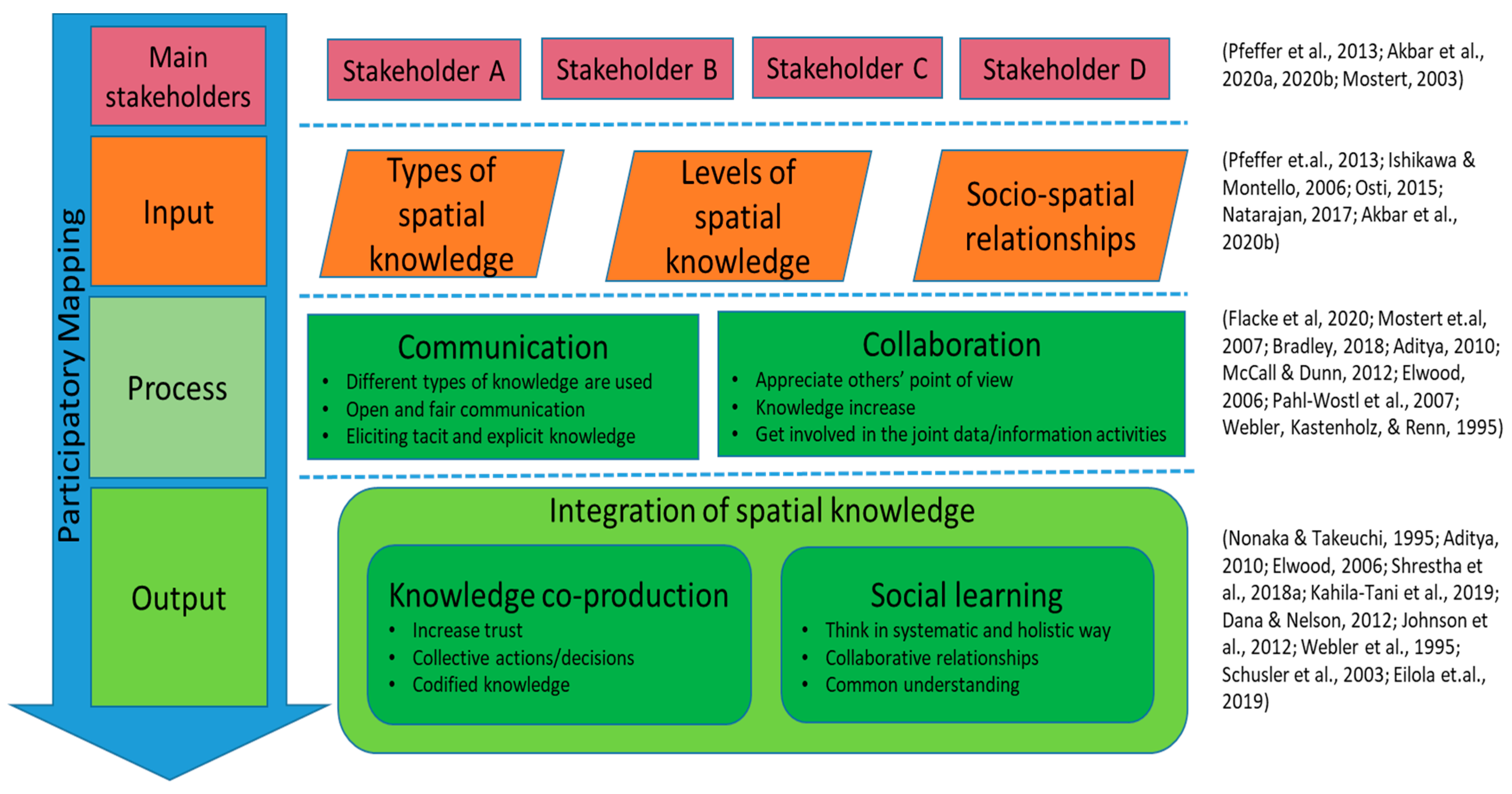
To better conceptualise a collaborative spatial learning framework to support SDGs’ operationalisation, we proposed a framework that would integrate the spatial knowledge of the stakeholders, as can be seen in Figure 1 below.
The framework is divided into four main stages. Diverse stakeholders with different types and levels of spatial knowledge and socio-spatial relationships will work collaboratively in a participatory mapping workshop. The process stage would allow diverse stakeholders with distinct spatial knowledge to elicit their spatial knowledge, communicate and collaborate to produce joint maps in a participatory manner. In the next stage, it is expected that stakeholders could integrate their spatial knowledge through knowledge co-production and social learning experiences. Therefore, the involvement of relevant stakeholders as the primary users and beneficiaries of the maps during the mapmaking process is fundamental. These created maps should fit the local context [49], and mapping activity should be doable, particularly for participants with little or no experience with mapping technologies [8]. For these purposes, satellite images will be used in the mapping workshops because it could help different stakeholders to better understand the mapped areas while allowing them to use their spatial knowledge effectively during mapmaking processes [24].

3. Implementation of the Collaborative Spatial Learning Framework

3.1. Context

This research was developed in the context of public participation practices in rural Indonesia, which is known as the Musrenbang. The Musrenbang is a participatory planning and budgeting practice held annually to formulate and produce the planning and budgeting documents [9]. Problems of the Musrenbang include limited knowledge sharing or integration among stakeholders [9,50], power relations among participants [51] and lack of data availability, particularly visualised geospatial data to support Musrenbang participatory planning practices [52].
In Indonesia, the laws 6-year 2014 stated that each village must have at least three maps, namely, a satellite image map, facilities/infrastructure map and land-use map. The government needs these maps for determining legal boundaries, supporting village development, deciding on village allocation funds [6] and supporting Musrenbang practices [52]. Until 2019, there were only 31,147 villages out of 83,436 villages in Indonesia that have been delineated in the village boundary map format [53]. Consequently, in the Musrenbang implementation, it is hard to find such data used to support the stakeholders’ discussions. Limited funding for mapping the whole village, diverse geographical terrain, a lack of expertise and technologies for producing maps and a lack of coordination among institutions are the main limitations that inhibit governments from producing village maps [7].
The framework of this study was implemented by applying participatory mapping workshops in three villages in the Deli Serdang district, Indonesia, namely, the Kramat Gajah, Kolam and the Denai Lama villages. All three villages did not have village maps, only a village sketch map hanging on the wall of each village office that was produced between the 1970s–1990s. Since the upper governments were unable to provide the villages with maps that had an accurate scale and coordinates, the current sketch village maps were useless to support decision-making processes in the villages.

3.2. Workshop Design and Implementation

This paper followed a participatory design approach by involving the Musrenbang village stakeholders in the design phase and the implementation of the mapping workshops [54,55]. In previous steps, activities, such as focus group discussion, questionnaire and semi-structured interviews with the village stakeholders, were conducted to elicit their opinions and ideas about the Musrenbang and the potential of spatial knowledge and geospatial data to improve the current village Musrenbang practices [9,11,56]. This involvement allowed the researcher to construct the collaborative spatial learning framework and to create the design of the participatory mapping workshops. Based on the results and findings of the previous work, we decided to capture the local knowledge of the stakeholders by applying image interpretation techniques through photo-mapping, supported with a sketch mapping method. The participants of the workshop drew their knowledge on existing satellite images using two different methods. They could draw the maps digitally by using a computer touchscreen and non-digitally by using analogue, traditional tools, such as transparent layers, markers and stickers.
There are various techniques in participatory mapping from low-cost and straightforward methods to high-cost and sophisticated techniques [26,57]. As this study was built on previous studies on improving public participation practices by utilising the spatial knowledge of the stakeholders [9,11], we conducted a participatory research design to gain insights from the village stakeholders when deciding the most suitable methods [54,55]. We did an experiment with the village stakeholders during interviews and focus group discussions by showing them several participatory mapping methods and tools, such as sketch mapping, drones, maptable and photo-mapping, to find out what worked best for them. Based on that experiment, most of our respondents preferred photo-mapping as the most convenient method for them to identify and draw their villages on maps. This finding was the main reason for using photo-mapping, understood as scale mapping activities using an aerial photograph or satellite images of the study area [57], as the primary method. Additionally, sketch mapping was used as the supplementary method to prepare the participants before the photo-mapping activities.
We applied the framework through three different participatory mapping workshops between October–November 2019. In each workshop, we used a Worldview high-resolution satellite image of each village. The satellite image data were taken between January–May 2019. Map symbols, lines, colours and other technical specifications required for the production of the village maps followed the guidelines of the Head of Geospatial Information Agency (BIG) regulation 3-year 2016 [6].
We applied two different types of mapping methods in the participatory mapping workshops to identify the strengths and limitations of each technique during the participatory mapping activities. The Kolam village used a non-digital participatory mapping method; this non-digital approach consisted of using transparent plastic layers above printed satellite images, and the participants drew their village maps on the plastic sheets using markers and stickers. In the Kramat Gajah village and Denai Lama villages, we used a digital participatory mapping method using an application called OGITO (Open Geospatial Interactive Tool), which is an open-source software application designed to support collaborative spatial planning processes with a maptable [56,58]. The application displayed the satellite image on a touchscreen monitor, and the participants drew the maps by touching the screen with their fingers on top of it (Figure 2 and Figure 3). The features of the application were written in the local language (Bahasa Indonesia) to ease the participants to understand and use the OGITO. The name OGITO was derived from the words ‘Oh Gitu’, meaning ‘Oh, I got it’ or ‘Okay, I understand’ in Bahasa Indonesia. It was inspired by the reactions of some participants when using the tool during the mapmaking process. When they managed to use the tool or they showed an understanding of something or the tasks given, they would say these words.
A maptable used for digital mapping. It had a display size of 27-inches. As a result, fewer participants could participate at the same time around the table in the digital mapping workshop than the non-digital mapping method (Figure 3). The number of participants was limited to a maximum of eight participants for the digital mapping and 40 participants for the non-digital mapping to ensure the effectiveness of the workshops. The participants represented the stakeholder groups who participated in the village Musrenbang, which consisted of the village head, village secretary, village council (BPD), village empowerment board (LKMD), community leaders, youth group (Karang Taruna) and women group (PKK). Furthermore, we only considered the representativeness of the village stakeholders’ groups regardless of age, educational level and mapping experiences of the participants. We limited the participants of the workshops to the representatives of the stakeholder groups who attended the Musrenbang implementation because we wanted to keep the participants in the mapping workshops as similar as possible with the participants in the real Musrenbang situation. We did not interfere with the existing power structures within the village, i.e., the villagers took the decisions of who should be invited to the workshops based on a list that we provided. Based on this list, the village officials had an internal discussion with other stakeholders in the village to decide on the participants who would become the representatives of each stakeholder group and then invited them to the workshops.
At the day of implementation, we had more participants for the digital workshops because the village officials invited more people to their workshops. However, it appeared that not all participants were able to attend the workshops, especially women participants in Kramat Gajah and Denai Lama. The workshops in Kramat Gajah and Denai Lama were followed by 10 and 16 participants, respectively; all participants were males. The workshop in Kolam village was attended by 30 participants, 15 males and 15 females. The profile of the participants in all villages can be seen in Appendix A.
Each mapping workshop was implemented in the village hall, and participants spent close to one full day for the implementation—five hours in Kramat Gajah and eight hours at the Kolam and Denai Lama villages. At least three facilitators were needed in the digital workshops for (a) moderating the discussion and guiding the mapping process; (b) providing technical assistance; (c) recording the workshop using videos, audios and observation notes. The non-digital workshops needed five facilitators, as three facilitators guided the participants (one per group) to draw maps, while the other two served as technical support and recorded the mapping sessions.
The workshop was implemented in the local language (Bahasa Indonesia) to ease communication among participants. During the workshops, the Javanese language was also used by the participants since the dominant population of the villages are Javanese. The facilitator who moderated the workshops is Indonesian, and he understood the local languages (Bahasa Indonesia and Javanese languages) as well as the cultural background of the participants. A script of workshop activities was also prepared to moderate the sequences of the workshop implementation (Figure 4) to have consistency in the sequence of activities in each group. The script was tested in three preliminary workshops and refined to meet the real context of the place where the workshops were undertaken.
In both mapping approaches, the session began with an introduction of the workshop and the study area. The participants were asked to manually draw their villages in a sketch map using a pen and a blank sheet of paper (No. 1). Thereafter, they were asked to compare and discuss their drawings in a group. This activity was intended to raise the participants’ awareness of their local knowledge about their villages so they would be more prepared when doing the real drawing using the mapping tools. The moderator gave a short explanation about the steps and mapping tools and then guided the participants in each mapping session (No. 2–4). Again, we asked the participants to identify and write down three main village problems individually (No. 5), followed by a group discussion to formulate possible development plans to solve the problems (No. 6). Thereafter, there was a group discussion to reach a consensus on five to ten proposed development plans (No. 6–7). Then, they were asked to draw the proposed development plans into the map (No. 8). At the end of the session, a short group discussion was conducted to reflect on their learning experiences and to complete a questionnaire (Appendix B).

3.3. Workshop Analysis

We used a list of assessment criteria and means of verification to evaluate the implementation of mapping workshops in integrating the participants’ spatial knowledge by enabling communication, collaboration, knowledge co-production and social learning among the participants (Table 1). Data for analysis were collected from four sources, namely, the village maps produced during the mapping session, observations (through voice recording, video recording and observation notes), a short-group discussion immediately after the workshop, a post-session questionnaire and semi-structured interviews with selected participants after the workshops.
The village maps captured the interactions between participants to integrate their spatial knowledge during the mapmaking process. The observations consisted of video, audio recording and observation notes so that the authors could recall and reflect on the workshop implementation when analysing the data. A self-reported questionnaire collected participants background, expectations and reflections on the workshop using a five points Likert scale [59]. All participants filled out the post-session questionnaire except for one participant from the Kolam village, who left the workshop early before the session ended. A short group discussion was held to gain participants’ opinions about the workshops, and both were held directly after each mapping workshop. We also conducted in-depth semi-structured interviews to obtain additional information about the mapping workshops (Appendix C). We interviewed 15 respondents in the Kolam village, nine respondents in Denai Lama, and eight respondents in Kramat Gajah. Furthermore, we analysed the data through content analysis [59] using ATLAS.ti. To fulfil the European General Data Protection Regulation-GDPR (https://gdpr-info.eu/), we always asked participants for their informed consent for using the audios, videos, pictures and questionnaire for research and publications before the data collection [58].

4. Insights from the Participatory Mapping Workshops

The presentation of the results has been divided into two parts. First, in the process stage, we discussed communication and collaboration among stakeholders. Second, we discussed knowledge co-production and social learning processes in the output stage.

4.1. Process Stage: Enabling Communication and Collaboration

Our findings showed that both approaches—the digital and non-digital workshops—supported communication and collaboration among the participants. The sketch mapping technique conducted at the beginning of the workshops was useful to prepare the participants before engaging in the scale mapping activity. It allowed participants to freely draw sketches of their village and to compare their drawings with their peers, and thus triggered communication and collaboration among them. The participants enthusiastically tried to combine their sketch maps to form their village, which brought positive influence to the next stage when they started to draw on the satellite images. The sketch map built their awareness about their local knowledge and prepared them mentally when engaging with the photomap activities.
The satellite images used in both workshops functioned as a platform for the participants to explore and navigate themselves in their villages. They were helpful by stimulating communication among participants, particularly when exploring or clarifying specific places around the villages. The results of the questionnaire indicated that both workshops (digital and non-digital methods) were quite useful to provide fair and open communication among participants (Table 2).
Most participants also gave positive responses that the workshops were helpful in expressing their opinions (Table 2). However, there was one participant in Denai Lama who gave a neutral response. It seems that the number of participants in the digital mapping workshop affected the participants’ chances to have a say in the workshop. Reflecting on the digital workshops, having more than eight people working around a 27-inch map table might not be convenient for some participants.
We also found that the majority of participants gave positive responses concerning they had the same opportunities to share their knowledge in the workshop (Table 2). In the interview, A9 said,” There was no problem in communication. The mapping workshop was running well. The (tool helped) communication getting better” (A9, personal communication, 18 February 2020).
Regarding collaboration among participants, both methods also got positive feedback. Most respondents in all of the villages also gave positive responses towards the statement that other participants listened to what they had to say (Table 3), indicating that they actively engaged in the mapping workshops, and their opinions received proper attention from other participants. However, in the Kolam village, there were three participants who responded neutrally to the question that other participants listened to them during the workshop. In this village, each working group was separated only by 3–4 m from the other groups, and the village hall was noisy due to the short distance. This might explain why three participants in Kolam village responded neutrally to the question. Besides, in the post-discussion session, a participant expressed that sometimes they could not hear what other participants’ were saying due to the noise.
Table 3 also indicates that all workshops were a success in increasing the participants’ knowledge about their villages. Even though seeing their village from the sky might be new for most participants, the satellite images proved to be effective in helping the participants to orientate and explore their villages. For example, in the interviews, respondents C4 stated, “Especially the boundaries. The satellite images clearly showed our villages, showed the village boundaries, (we can identify) the rice field (owners) and the borders. It was clear, very clear” (C4, personal communication, 7 February 2020); while respondent B1 conveyed.
“The satellite images used in the workshop displayed the real situation of our village, and we worked together to identify and draw the data (boundaries, facilities, land use). The workshop was helpful to sharpen our area knowledge and to fully understand our administrative area” (B1, personal communication, 28 January 2020).
The satellite images were also beneficial in increasing the participants’ knowledge about their villages and current geo-technologies, as implied by respondent A7, “I feel that my knowledge increased, especially with the (current map) technologies. It is getting easier (to use)” (A7, personal communication, 18 February 2020). The participants also expressed that the satellite images enabled them to think critically towards the information provided in the images. For instance, respondent B3 stated that the satellite images helped them to identify the changes of land use around their villages, “We get to know the village boundaries and also the land-use changes in our village. For example, I found a certain location, which was previously a rice field that had changed into settlements” (B3, personal communication, 12 February 2020).
The responses from participants confirmed the benefits of using satellite images in participatory mapping workshops. The true-colour composite of the satellite image that displayed natural colours enabled participants to better identify and explore their villages from the sky view. These benefits would be advantageous for them to better co-produce their spatial knowledge while experiencing social learning.

4.2. Output Stage: Experiencing Knowledge Co-Production and Social Learning While Creating Village Maps

Insights from the questionnaire and the short group discussion confirmed that both mapping methods were useful in motivating knowledge co-production among participants. They were able to actively contribute to each session of the workshops, codifying their spatial knowledge into the village maps. Participants reported that their trust in other participants increased after they collaborated in the mapping workshops (Table 4). This could be a good indicator that they would be able to collaborate on other projects, including in the Musrenbang public participation practices.
Most participants also stated their agreement by taking collective actions to use the maps produced during the next Musrenbang practice (Table 4). In the interview, respondent C8 said, “The implementation of Musrenbang will be much better. Previously, we could only guess where the exact location of the topic being discussed was. Now, we will be able to see the sites (as they will be) displayed on the village maps” (C8, personal communication, 11 February 2020).
The satellite images used in the digital and non-digital mapping workshops were helpful for the participants to work collaboratively by integrating and co-producing their spatial knowledge. For most participants, seeing their village displayed on a satellite image was something new for them. Thus, the satellite images helped them to better understand their village, facilitated the discussion and collaboration, while also co-producing their village maps, as required by the laws.
Regarding the social learning process, most of the participants expressed that they were able to work collaboratively as a group when doing the mapping exercises, which was indicated by most participants who chose “Strongly Agree” and “Agree” responses on the questionnaire (Table 5). Respondent A8 said, “We collaborated. Let me tell you why, when one participant drew a line, another participant checked the line, (if there were mistake) they corrected line, the line should be moved to this area, for example” (A8, personal communication, 18 February 2020).
Most participants also agreed that the workshops enabled them to learn from each other during the mapping processes (Table 5). In the digital and non-digital workshops, the session on drawing the boundaries, facilities and land-use maps resulted in the participants eliciting their existing knowledge or mental models. When developing the proposed development maps, the participants were brought into an intense discussion, where they were arguing and reasoning. The participants were then given the opportunity to change or compromise their existing knowledge or mental models when they reached a common understanding or consensus.
Positive responses were also given towards the question of learning from each other. From the observations, the learning processes can be seen through how the participants distributed the mapping tasks. The older-aged participants in the digital workshop seemed to be more passive than the older-aged participants in the non-digital workshop. In Kramat Gajah and Denai Lama, younger participants acted as the drawer on a maptable, while the older-aged participants observed their younger colleagues drawing. When we asked for the reasons as to why they did not draw, they responded that the youths were better at drawing, and the drawing tool can only be used by one person at a time when drawing (A9, personal communication, 18 February 2020). Nevertheless, the older-aged participants could still contribute by giving information about boundaries or places that the younger participants did not know, as portrayed in Figure 5. Moreover, they were still active by giving or verifying information during the mapping process. Through these interactions, participants exchanged spatial knowledge while increasing knowledge about their villages.
In the non-digital mapping workshop, the collaboration of the older-aged participants was more active during the mapping process. For example, in Figure 5, the man wearing the black cap was more than 70 years old, but he was quite active in the mapping process. The task distribution went better than the digital mapping since every participant in the group could work manually and was drawing on the maps at the same time. Figure 5 also depicts how the women participants actively engaged in the mapping process of the Kolam village, while in the other two villages with digital mapping workshops, women’s involvement could not be investigated due to no women participants attending the workshops.
The questionnaire also revealed that most participants agreed that the workshops were helpful in assisting them in identifying the villages’ main problems (Table 5). However, there were four participants who did not show agreement—one participant in Kramat Gajah and three participants in the Kolam village. In the discussion and interviews, it was revealed that participants were in disagreement because they were confused about the administrative village boundaries. In Kramat Gajah, participants had an intense discussion about the vast plantation area along the river bank. Even though the area is located in the Kramat Gajah village, the village has no rights because the river and the banks are under the control of the central government, as stated in the laws. In the Kolam village, the participants discussed the legal boundaries of a neighbourhood. The area is out of their administration, but all the citizens who live in the area are administratively registered as citizens of the Kolam village. They cannot make decisions about the boundaries, as they have to consult with external parties who were not involved in the workshops, such as the upper government and the adjacent villages. Even when facing confusion, these findings showed that the administrative boundaries play a critical part in assisting the participants in identifying their villages’ underlying problems. The discussions that arose from the village boundaries also indicated that the workshops helped participants think systematically beyond the tasks that we provided. The information displayed on the satellite image was powerful in triggering discussions among the stakeholders. Moreover, the mapping workshops were helpful to encourage participants to critically reflect on sustainable development agenda when thinking and acting at the local-village scale.

5. Discussion

Proper geospatial data is urgently needed to achieve and monitor the SDGs implementation [4]. The UN-GGIM promotes this urgent need by encouraging countries to improve their geospatial management strategies and to provide accurate and reliable geospatial data for supporting the development processes [2]. Maps, as the visualised spatial data, play an essential role to address the complex and interlinked issues of SDGs implementation [5]. However, the application of SDGs is often confronted with problems of contextualization, concerning global goals, targets and indicators. The operationalisation at the national level is quite challenging, while at the local level, including rural areas, localising the SDGs concept into actions is more challenging [4,60,61].
Indonesia, as a country adopting the SDGs in its national policies, faces the same circumstances. The government has launched the One Map Policy aiming to fulfil the geospatial data availability at the national, regional, district/cities and rural levels while supporting the SDGs implementation in Indonesia [53]. Even though village maps are mandated by the laws, up to 2019, there was only about 37 per cent of the village boundaries, which have been delineated [6]. This percentage should be a warning for the governments to take substantial actions to accelerate the village map production, as time is ticking, and SDGs will end in a few years.
The government, through the Geospatial Information Agency (BIG), has published regulation 3-year 2016 as the guidelines for the village map production. Moreover, the government has also encouraged citizens to contribute actively in the mapmaking processes by launching an application of PetaKita (https://petakita.big.go.id/) to enable citizens to participate in mapping their areas. The utilisation of the app was less successful in engaging citizens due to sophisticated map features, low intuitivity and user-friendliness as it needed to be connected to the internet when using it [32]. In contrast, other participatory mapping initiatives, which facilitate people to have direct interactions in the mapmaking processes, have better results to engage people to contribute [28,62,63]. As the SDGs place a specific emphasis on the participatory process, thus encouraging the production of geospatial data in a participatory manner, the contextualisation of global and national geospatial data targets into a local-rural scale is necessary. Developing a collaborative spatial learning framework, which has an impact on SDGs, notably on target 11.3 and 16.7, is urgently needed. For this reason, the participatory mapping workshops used in this paper emphasised on the process of communication, collaboration, knowledge co-production and social learning during the mapmaking processes.
Our findings showed that the mapping workshops gave significant positive outputs to pursue the SDGs operationalisation at the rural scale while achieving the SDGs and national targets to have proper village maps aiming for sustainable development processes. The workshops also helped village stakeholders to better understand sustainable development issues in the local context. Discussion about waste management, for instance, occurred during the mapmaking processes, although this was not listed in the mapping tasks. Some participants also became aware of the land-use changes in their villages. They criticised the changes by discussing the significant conversion of agricultural areas into settlement areas, which could endanger their main livelihood and thus increase poverty (SDG 1). They also had an intense discussion about the water allocation for their rice fields that might affect not only the farmers in their villages but also farmers in other villages, which used the same water resources (SDG 6). All these topics of discussions might seem simple and with moderate impacts for reaching the SDGs agenda. Still, in reality, it clearly shows how the grass-root citizens react to the SDGs issues, and how they gain awareness about the SDGs, and why it is crucial to apply village development in a sustainable way at the local context. By putting this information and knowledge on maps, the villagers, as the smallest social structure within the governmental hierarchies, have made their contribution to achieving the SDGs agenda [5].
Our findings also showed that in the local context, such as rural areas, the digital and non-digital participatory mapping approaches facilitated communication and collaboration among the participants. Moreover, the methods were also useful in integrating the spatial knowledge of the stakeholders while also supporting knowledge co-production and social learning processes. Our results were similar to other studies that showed how the non-digital and digital media of mapping were helpful in increasing the spatial understanding of the participants [64,65,66].
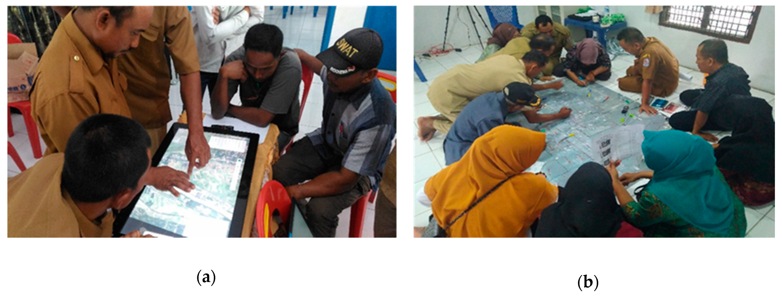
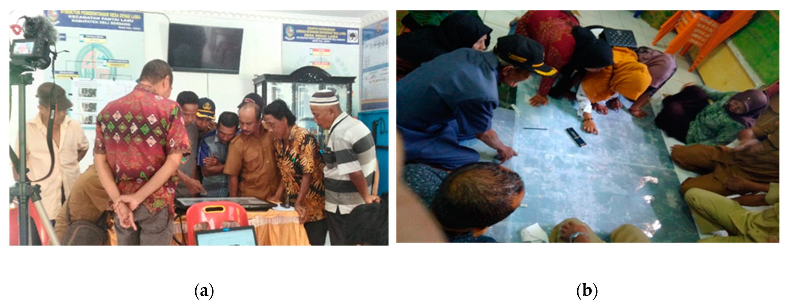
Each mapping method has its own strengths and limitations. Non-digital mapping was powerful in engaging more people to participate, as people with less or no prior experience with digital geo-technologies were able to engage in the process [8]. The materials needed for the workshops were less expensive and easy to prepare. However, this method was complicated during the post-processing stage because the researcher needed to work harder to manually convert all the drawn objects from the transparent plastic layer into the digital map format. This method also required a large room for implementation and more facilitators to guide the processes.
In contrast, digital mapping was easy for the map post-processing stage. Fewer mistakes were made because the objects drawn by participants were more comfortable to interpret by the researcher. This method only required a small room and fewer facilitators for implementation. The drawbacks were that fewer people were able to engage due to the size limitations of the computer screen. The development of the mapping application needed particular expertise and was not easy to handle. The technology barrier could also be challenging, particularly for participants with a lack of knowledge or experience with geo-technologies. We should acknowledge that the potential strengths and limitations of using specific mapping approaches are highly context-dependent, beneficial in one situation, but maybe not as helpful in other contexts [16,33,39]. Despite the successful implementation of the mapping workshops in this study, some issues need to be adequately managed to achieve excellent participatory mapping workshops.
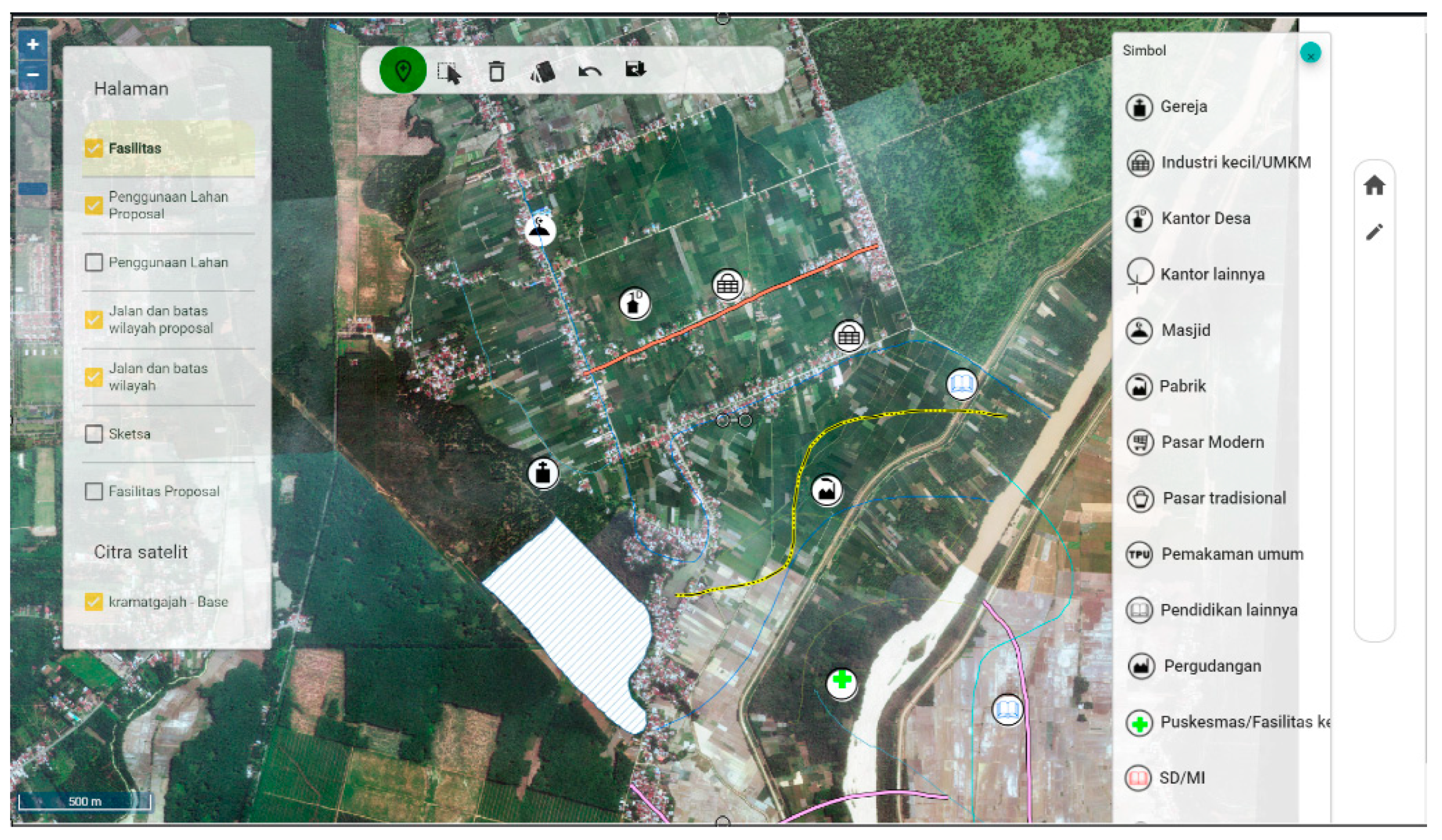
When selecting a participatory mapping method to use, Corbett [63] recommended certain factors to be considered, namely, how accurate the final product needs to be; how it will be utilized; the available resources for the mapmaking process. In this study, we chose to use the photo-mapping method by drawing the maps on high-resolution satellite images. The use of high-resolution satellite images for the mapping workshops helped the participants to better engage in the mapping processes while ensuring the maps were produced accurately. The satellite images use a true-colour composite that can display objects in the same, natural colours that human eyes would typically see them. Thus, the natural colours helped the participants interpret the information provided on the satellite images [24,28]. Using a georeferenced image, such as a satellite image in the participatory mapping workshops, offers more details of the landscape of the villages; therefore, it enhances the participants’ spatial and functional understanding of their village areas, even for participants with no previous mapping experiences [8,57,60]. In this study, the satellite images increased the participants’ understanding of their village, the village boundaries, existing land use and the village infrastructure/facilities.
It is also essential to use the most suitable map scale during the workshops since it might affect the participants’ engagement in mapping processes. For digital mapping, the participants can apply the zooming in-out feature to get the most suitable scale when drawing; however, this is not possible in the non-digital mapping workshop. In the non-digital workshop, 1:2500 printed satellite images were used. Using the scale maps drawn on existing scaled satellite images helped the participants interpret the objects more accurately and oriented themselves while viewing the satellite images [26]. The scale map drawing was also helpful for post-processing to transform the manual hand-drawing maps into digital maps.
The requirements imposed by the regulations, to some extent, could inhibit the participants from expressing their tacit knowledge. The strict technical specifications required by regulation 3-year 2016, published by the Geospatial Information Agency (BIG), often created confusion for the participants. For instance, when they wanted to draw a specific object on the satellite images, they had to choose the standard lines, symbols and colours imposed by the regulation. The participants often used their local spatial knowledge by expressing uncertain boundaries, shapes or symbolic interpretations when describing the village landscapes [14]. By only allowing them to use the standard guidelines, we may lose diverse, valuable, local knowledge and the original information owned by the local people [66]. Therefore, the mapping method should provide support for the participants to express local knowledge in their own way or even in their own local language. Wartmann and Purves [67] underlined this issue. They argued that participatory mapping approaches should enable communities to use their local language during the mapmaking process. Further, the map produced should also adopt the local language of the communities to better represent the localness of the information captured on the maps. We were also confronted with this issue. Translating or capturing the tacit knowledge into spatial knowledge depicted on a map was also a tricky part in each workshop. Our digital and non-digital mapping workshops applied sketch mapping to enable participants to better elicit their tacit knowledge. The sketch mapping was useful for facilitating participants to draw a rich picture that might not be available in the mapping tool features [30]. Sketch mapping method provides participants with free choices to draw and visualise their desired spatial objects [17,65]. Rambaldi [68] stated that the selection of features used in mapmaking processes is a crucial success of participatory mapping approaches since it would determine how the local knowledge is captured or drawn, and stimulating the sense of ownership and the benefits of maps among the communities. As a result, the maps produced by the communities would be more useful for the local use and understandable to the local communities. Thus, an amendment of current government regulations that allows local communities to draw their tacit knowledge into participatory maps should be a priority for governments, especially when they are aiming at reaching the SDGs targets in public participation practices.
The success of participatory mapping during the digital and non-digital workshops requires excellent facilitation. The facilitator should guide and create an inclusive workshop while inviting all participants to actively engage in each mapping session. The facilitator needs to provide an inclusive mapping process, where diverse participants with little or no mapping experiences are involved. To reach an inclusive process, the facilitator needs to use proper instructions with terminologies that are understandable for all participants [8,40]. The number of participants also influences the implementation of the participatory mapping process. The more participants engaged in a workshop, the more complex the process could become. The number of participants highly depends on the context and the methods used for the mapping workshops. Moreover, the purpose of the mapping workshop, types of spatial data to be produced and the level of accuracy of the expected results have to be clear when selecting the participants [22,69]. It is important to note that in a participatory mapping process, the representativeness of key stakeholders as participants is indispensable [28]. However, involving all relevant stakeholders in the village area does not guarantee that the quality of the maps produced will increase. In this study, there were many participants, especially younger participants, who had a lack of knowledge about their villages before the workshop, indicating less local knowledge that could be captured during the mapping process. They acquired new knowledge about the village area from the older-aged participants who were more passive during the mapping process. Although the elders tended to be more passive during the mapping process, they were knowledgeable and became the primary source of knowledge about the village areas. Conversely, the elders learned how to use the mapping tool from the younger participants. This mutual learning experience among the younger and older participants clearly showed how knowledge co-production and social learning occurred during the mapping process.
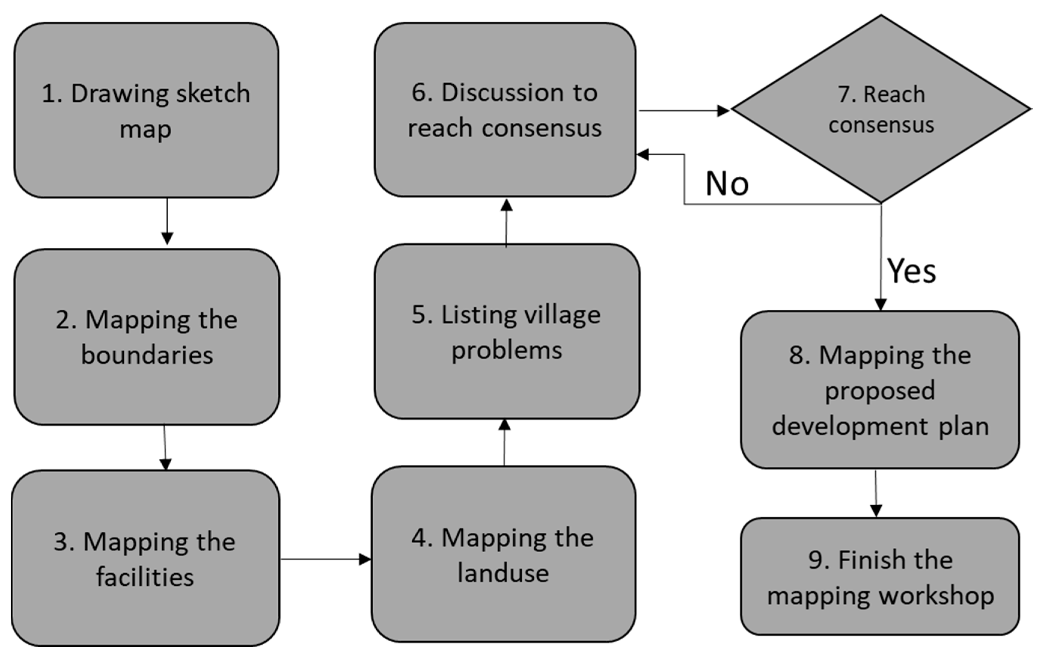
The knowledge co-production process was also evident when participants worked collaboratively to codify their spatial knowledge into village maps. If we refer to Nonaka and Takeuchi’s knowledge co-production process [44], the participants were actively using their tacit and explicit spatial knowledge. The participants discussed their tacit knowledge to other participants when they started to communicate during the initial stage of the workshop. They externalised their tacit spatial knowledge through a sketch mapping exercise. The combination was evident when they compared their sketch drawing results and started to draw on the satellite images. Furthermore, they internalised their spatial knowledge by coming to a consensus and learning new knowledge during the discussions. Their trust for the other participants increased when they took collective action and reached an agreement over the proposed development map. This finding proved that a stakeholder-driven approach, such as participatory mapping, is useful to better understand the region and stimulate the co-production of knowledge [21].
The social learning process was also evident when the participants started to understand that they could work collaboratively to produce their own village maps. The experience enabled them to collaborate on other future projects. Single-loop and double-loop learning were also evident when the participants gradually acquired new knowledge while transforming their initial values or views [45,70]. For instance, single-loop learning occurred when participants felt a common understanding of needing to use maps when discussing village problems. The participants started to think systematically and holistically beyond the tasks given during the mapping workshops. In the Kolam village, participants discussed the solid-waste management problem during the mapping process, even though waste management was not listed in the task sequences prepared by the facilitators. Some participants also expressed their satisfaction in the interview, where the exact width of the area for each land use could now be measured accurately in their new village maps. Again, these findings clearly showed that participants had started to reflect on sustainability issues when discussing the development processes in their villages. The learning experiences are an example of how rural citizens could also contribute to the upper or central governments’ efforts to achieve the SDGs.
Double-loop learning occurred when the participants started to realise that the maps could be used for other developmental purposes. Instead of having only three categories of maps required by regulations, they co-created other maps that they needed. The Kolam village made the neighbourhood maps and distributed the maps to each head of the neighbourhood. The head of the neighbourhoods was now responsible for updating the maps with data, such as the names of family members in each household, new or broken facilities or distribution of social safety nets in the neighbourhoods. The Denai Lama village created a farmers’ group map to display the distribution of land allocation for each group. Thus, the visualised geospatial data and learning experiences enabled the stakeholders to better formulate their decisions and actions [8].
In this study, the method was implemented in one full day, reducing the field day and cost of implementing a participatory mapping workshop. It is important to note that an all-day workshop requires careful preparation, skilful facilitation, suitable methodologies, sufficient allocated time and manageable tasks [20,63]. However, the applicability of the participatory mapping method in different contexts should consider the livelihood of the participants, cultural settings, as well as the landscape environments where the participants live and do their activities. For example, in a village where most citizens do pastoral and grazing activities, a mobile mapping tool should be more reliable to get better map results [27], or planning the schedule properly to suit the available time of the participants to contribute on the mapmaking process [63].
In this study, we also discovered that an unequal power relation among participants became a major impediment in the participatory processes. The fact that in two out of three villages, no females were involved in the mapping workshops contradicts the SDGs target 11.3 and 16.7, which emphasise the representativeness of people in participatory processes based on sex, age, disability and minority groups [71]. The strict patriarchal values within the social structure could be a reason why less or no women were involved [72]. Most of the prominent positions in the villages are held by men. In the village structure, the women group was only represented by the PKK organisation, while the PKK is often chaired and organised by the wives of the village government officials. Moreover, the village officials often have more power to decide who should be invited into a meeting or workshop [9]. These circumstances eventually limit options for women groups in the villages to participate actively in the public participation practices, including in the participatory mapping workshops.
Hence, some methods could be useful to overcome this shortcoming, for example, by choosing the most suitable time for the targeted participants to attend the workshop [63]. Other alternatives might be by providing visualised mapping tools, which can engage more participants [18], visiting the households [25] or using online mapping [19]. However, even though all of these requirements are fulfilled, it would not guarantee that the participatory mapping activities are free from power gaps. Therefore, the facilitator plays an essential role in moderating the interaction of the participants. As facilitators are often confronted with power relations among participants, designing and facilitating a workshop that can accommodate different groups of stakeholders, particularly marginalised groups, is crucial [21,63,73]. A combination of internal and external facilitators might help to reduce the biases caused by the community power structures towards the workshop implementation [63].
This study was more than just an extractive approach for gathering data because, during the mapping workshops, the participants also had an intense discussion to identify main problems that need to be addressed in their village. They also made suggestions and took decisions about possible solutions or potential projects that should be done to solve the problems, for example, by proposing to build new schools, to renovate a bridge or to build a dam. Then they put the project priorities into a village proposed development plan map, so that the map can be used during the Musrenbang discussion sessions or to submit proposals for funding allocations to upper governments. However, the final decisions, whether the project priorities would be implemented or not are beyond the scope of this paper because they will be discussed and decided in the Musrenbang practices. If we refer to Arnstein’s ladder of citizen participation [74], the participatory process occurred in this participatory mapping workshop could be classified at the partnership level. The workshops helped participants to generate localised knowledge. Furthermore, participants’ opinions or suggestions were taken into account during the mapmaking process. These two examples indicated that the participatory process at the partnership level occurred during the workshops.
We acknowledge that the mapping workshops had some limitations. First, the composition of the participants was still far from ideal; for instance, there were no female participants at the Kramat Gajah and Denai Lama workshops. Ideally, the composition should not only consider the representativeness of the stakeholder groups but also include the gender, education level and other socio-economic characteristics, as prescribed by the principles of SDGs - leaving no one behind [1]. For future research on participatory mapping approaches, it is crucial to include more women and, in general, more participants in the mapping activities. The representativeness of relevant stakeholders would ensure the participatory mapping activities to achieve a higher degree of participation, capture more knowledge to gain more reliable results and prevent participation into a small-group elitist activity [16,25]. Second, the cultural background of the participants, which tended to be polite and not very open to criticism, might influence the participants’ feedback. Therefore, having different sources, such as observations and in-depth interviews, was helpful to crosscheck the responses given on the questionnaire. Third, technical issues, such as the computer screen size and quantity, should also need further consideration. Having larger computer screens, providing more displays or developing an online mapping platform might be useful in engaging more participants. The more participants engaged, the more knowledge can be captured during the participatory mapping processes.
It is also important to note that the rapid changes in the world situation might require immediate adaptation towards the participatory mapping practices. During the implementation of the workshops, gathering lots of people in a participatory mapping activity was not a problem. However, after the Covid-19 pandemic started, it appears that we need to change the participatory mapping methods, which have less direct contact or interactions due to physical distancing policies. Maceachren and Brewer [75] in their paper mentioned that collaborative mapping could be implemented in four space-time situations: same time-same place; same time-different place; different time-same place; different time-different place. In this current pandemic situation, applying a participatory mapping workshop that facilitates group collaboration in different places but at the same or different time might be a better option to keep everyone safe during the mapmaking process.

6. Conclusions

In this study, we sought to develop a suitable approach to achieve the SDGs in terms of providing geospatial data to support decision-making processes at the local level. We developed a collaborative spatial learning framework to integrate the spatial knowledge of the stakeholders by building upon their communication and collaboration and facilitating knowledge co-production and social learning experiences. Through three participatory mapping workshops in the case study areas, this study clearly showed that the workshops helped to increase the participants’ awareness to understand and apply sustainable development at the rural scale while helping them to produce accurate and georeferenced village maps. The photo-mapping method by using satellite images was useful to support the stakeholders’ communication and collaboration and eventually, integrated the stakeholders’ spatial knowledge through knowledge co-production and social learning processes. Working with satellite images was helpful to capture local spatial knowledge, increase the knowledge of the participants, support the collaboration of diverse stakeholders, and assist the co-production of reliable and accurate geospatial data. To be successful, having a clear and direct task sequence and skilful facilitators are necessary to actively engage the participants during a participatory mapping process. Yet, how the outcomes of such mapping experiences would affect the behaviour of the participants in a real public participation practice is still uncertain. In the long run, the impact of this initiative to achieve the SDGs also needs further investigation. Therefore, further studies may be worthwhile on how such mapping experiences and co-produced geospatial data could enhance public participation practices in villages, while also contributing to the achievement of SDG targets.

Author Contributions

Conceptualisation, Aulia Akbar, Johannes Flacke, Javier Martinez, Rosa Aguilar, Martin F. A. M. van Maarseveen; methodology, Aulia Akbar; validation, Aulia Akbar; formal analysis, Aulia Akbar; data curation, Aulia Akbar, Rosa Aguilar; writing—original draft preparation, Aulia Akbar; writing—review and editing, Aulia Akbar, Johannes Flacke, Javier Martinez, Rosa Aguilar; visualisation, Aulia Akbar; supervision, Johannes Flacke, Javier Martinez, Martin F. A. M. van Maarseveen. All authors have read and agreed to the published version of the manuscript.

Funding

This research was funded by the Ministry of Finance for the Republic of Indonesia’s Indonesian Endowment Fund for Education (LPDP), grant number PRJ-561/LPDP/2015.

Acknowledgments

We would like to thank the Ministry of Finance for the Republic of Indonesia’s Indonesian Endowment Fund for Education (LPDP) for supporting this research. We thank all of our respondents in the Kramat Gajah, Kolam, and the Denai Lama villages, Deli Serdang district, who enthusiastically responded to our questions and helped our fieldwork. We thank Muhammad Farouq Ghazali Matondang, Ziki Wahyu Rinaldi, Faisal Andrean, Umar Hamdan Hasibuan, Andrian Lozi, DTM Damai Syahputra, and our colleagues at the State University of Medan (UNIMED) and the University of Sumatera Utara (USU), for providing technical support during the data collection. We thank the IndieMap for the finalisation of the village maps. We also thank the anonym reviewers for providing useful comments that helped to improve this paper.

Conflicts of Interest

The authors declare no conflict of interest.

Appendix A

Table A1. Profile of the participatory mapping workshop participants.
AttributesVillages
Denai LamaKramat GajahKolam
(n = 16)(n = 10)(n = 29)
Freq%Freq%Freq%
Respondents’ background
Age (year)
18–30160000
31–5012756602586
51–65319440310
More than 65000013
Sex
Male16100101001448
Female00001552
Education
Primary school1611013
Junior high school425330724
Senior high school9565501862
Diploma160027
Bachelor160013
Not say0011000
Role in the village
Village officials53144027
BPD (Village council)425110310
LKMD (Village development board)31911000
Head of neighbourhood425330931
PKK (Women group)00001138
Karang Taruna (Youth group)000000
Tokoh masyarakat (community leaders)00110414
Others000000
Respondents’ Literacy
Frequency of Use
Computer
Daily63833027
Every week160000
Once per month000013
Few times per year162201034
Never8505501655
Digital maps
Daily2130000
Every week21300621
Once per month160000
Few times per year213660828
Never9564401552
Paper maps
Daily2130000
Every week21311013
Once per month0033013
Few times per year11696601138
Never16001655
Participation in a group mapping activity
Never3193301138
1–2 times11696601655
3–5 times1611027
More than 5 times160000
n = number of respondents (attendees who filled the questionnaire).
In Kolam village, from thirty participants, there was one participant who left the workshop early and did not fill the questionnaire.

Appendix B

Questionnaire

This survey is part of the mapping activity in the village: _________. Your participation will be a great help to us. Please agree or disagree with the following statements. The responses will be kept anonymous. They will be used to better understand your perception of the participatory mapping workshop. In addition, summarised data will be used in scientific articles to be published. Please complete this survey before you leave.
Thank you for your participation!

Part 1. Your perception of the participatory mapping workshop.

By Participating in This Participatory Workshop…Strongly DisagreeDisagreeNeutralAgreeStrongly Agree
I learned a lot about our village12345
My knowledge about my village increased12345
We identified the villages’ underlying problems12345
We collaborated as a team in the mapmaking process12345
The participants discussed the issues in an open way12345
I could articulate my opinions during the mapping workshop12345
Each participant had the same opportunities to share their knowledge12345
Other participants at the workshop listened to what I said12345
We learned from each other during the mapping workshop12345
After this workshop, my trust in other participants increased12345
I believe the map produced would be useful for village development12345
I would recommend using maps during the Musrenbang practice12345

Part 2. About yourself.

This part aims to know about your personal background and experience with maps and participatory mapping activities. Please fill the questions below by selecting one of the given options.
  • Fill in your gender:
    ☐ Female ☐ Male ☐ Prefer not to say
  • Age group:
    ☐ <18 years ☐ 18–30 years ☐ 31–50 years ☐ 51–65 years ☐ >65 years
  • Select your highest completed educational level
    ☐ Primary School ☐ High School ☐ Bachelor ☐ MSc ☐ PhD
  • What role do you hold in the community organisation?
    ☐ Village official, as: ________
    ☐ Village council (BPD), as: __________
    ☐ Village development board (LKMD), as: ___________
    ☐ Women group (PKK), as: __________
    ☐ Youth group (Karang Taruna), as: __________
    ☐ Community leader.
    ☐ Other. Please specify: _________
  • How often do you use a computer/laptop?
    ☐ Never ☐ Few times per year ☐ Once per month ☐ Every week ☐ Daily
  • How often do you use a map in the paper?
    ☐ Never ☐ Few times per year ☐ Once per month ☐ Every week ☐ Daily
  • How often do you use a digital map (e.g., in a phone)?
    ☐ Never ☐ Few times per year ☐ Once per month ☐ Every week ☐ Daily
  • Have you participated in a group mapping activity?
    ☐ Never ☐ 1–2 times ☐ 3–5 times ☐ More than five times

Appendix C

In-Depth Interviews of the Participatory Mapping Workshop Participants

This interview is part of the mapping activity in the village: _________ to gain additional information about your perception of the participatory mapping workshop. Your participation will be a great help to us. The interview will be recorded, and your responses will be kept anonymous. The data will be analysed and used in scientific articles to be published.
Background information
  • What is your name?
  • What is your occupation?
  • How long have you worked there? Where did you work before?
  • What is your role in the village?
  • What is your education?
  • Can I have your phone number? Can I call your number if I have other questions?
The participants’ experiences with visualised geospatial data and mapping workshop
  • Have you ever used a paper map before the mapping workshop? Please explain.
  • Have you ever used a digital map on a computer before the mapping workshop? On your mobile phone? Please explain.
  • Have you ever used a satellite image before the workshop? Please explain.
  • Have you ever participated in a participatory mapping workshop before the workshop? Please explain.
The implementation of the participatory mapping workshop
  • What do you think about the methods used during the participatory mapping workshop?
  • What do you think about the mapping tools? Please explain.
  • What were the strengths of the mapping workshop? What were the benefits? Please explain.
  • What were the challenges that you had during the workshops? Please explain.
  • What were the limitations of the mapping workshop that could be improved? Please explain.
  • What do you think about the tasks given during the workshop? Please explain.
  • What do you think about the time allocation? Please explain.
  • What do you think about the moderation of the workshop? Please explain.
  • Did you find the satellite image that we used was useful? Why? Please explain.
The communication and collaboration
  • What do you think about the communication among the participants during the workshop? Please explain.
  • What do you think about the knowledge used during the workshop? Please explain.
  • In your opinion, to what extent the participants use and share their knowledge? How? Please explain.
  • To what extent did the workshop allow each participant to share their opinions of knowledge? How? Please explain.
  • What do you think about the collaboration among the participants during the workshops? Please explain.
  • Did participants in the workshop appreciate others’ point of view? How? Please explain.
  • Did your knowledge about the village increase after participating in the workshop? How? Please explain.
The knowledge co-production and social learning
  • What do you think about the integration of spatial knowledge during the workshop? Please explain.
  • To what extent did your trust to other participants increase after participating in the workshop? Please explain.
  • What kind of collective actions or decisions were made during the workshop? Please explain.
  • What do you think about the maps produced during the workshop? Would you recommend to use the maps in the Musrenbang or other projects? Why?
  • Did the workshop help participants to codify their spatial knowledge? Why? How? Please explain.
  • To what extent did the workshop help participants to think systematically? How? Please explain.
  • To what extent did the workshop help participants to think holistically? Please explain.
  • To what extent did the workshop help to build the relationships among participants so that participants were willing to collaborate? How? Please explain.
  • Did the workshop help participants to reach a common understanding? How? Please explain.

References

  1. The United Nations. The Sustainable Development Agenda. Available online: https://www.un.org/sustainabledevelopment/development-agenda/ (accessed on 22 June 2018).
  2. UN-GGIM Integrated Geospatial Information Framework: A Strategic Guide to Develop and Strengthen National Geospatial Information Management. Available online: https://ggim.un.org/meetings/GGIM-committee/8th-Session/documents/Part1-IGIF-Overarching-Strategic-Framework-24July2018.pdf (accessed on 11 June 2020).
  3. Janoušková, S.; Hák, T.; Moldan, B. Global SDGs assessments: Helping or confusing indicators? Sustainability 2018, 10, 1054. [Google Scholar] [CrossRef] [Green Version]
  4. Scott, G.; Rajabifard, A. Sustainable development and geospatial information: A strategic framework for integrating a global policy agenda into national geospatial capabilities. Geo-Spat. Inf. Sci. 2017, 20, 59–76. [Google Scholar] [CrossRef] [Green Version]
  5. Kent, A.; Vujakovic, P.; Eades, G.; Davis, M. Putting the UN SDGs on the Map: The Role of Cartography in Sustainability Education. Cartogr. J. 2020, 57, 93–96. [Google Scholar] [CrossRef]
  6. Patmasari, T. The Role of Geospatial Information for Accelerating the Delineation of Village Boundaries in Indonesia using Cartometric Method. Int. J. Adv. Eng. Res. Sci. 2019, 6, 46–58. [Google Scholar] [CrossRef]
  7. Ambarwulan, W.; Wulan, T.; Lestari, S.; Patmasari, T.; Suparwati, T. Application of Remotely Sensed Satellite Imagery for Village Boundary Mapping in Indonesia: Case study in Hulu Sungai Tengah Regency, South Application of Remotely Sensed Satellite Imagery for Village Boundary Mapping in Indonesia: Case study in Hulu S. In Proceedings of the FIG Congress 2018, Istanbul, Turkey, 6–11 May 2018. [Google Scholar]
  8. Eilola, S.; Käyhkö, N.; Ferdinands, A.; Fagerholm, N. Landscape and Urban Planning A bird’s eye view of my village – Developing participatory geospatial methodology for local level land use planning in the Southern Highlands of Tanzania. Landsc. Urban Plan. 2019, 190, 103596. [Google Scholar] [CrossRef]
  9. Akbar, A.; Flacke, J.; Martinez, J.; van Maarseveen, M. Participatory planning practice in rural Indonesia: A sustainable development goals-based evaluation. Community Dev. 2020, 1–18. [Google Scholar] [CrossRef]
  10. Natarajan, L. Socio-spatial learning: A case study of community knowledge in participatory spatial planning. Prog. Plann. 2017, 111, 1–23. [Google Scholar] [CrossRef] [Green Version]
  11. Akbar, A.; Flacke, J.; Martinez, J.; van Maarseveen, M. Spatial Knowledge: A Potential to Enhance Public Participation? Sustainability 2020, 12, 5025. [Google Scholar] [CrossRef]
  12. Bradley, Q. Neighbourhood planning and the production of spatial knowledge. Town Plan. Rev. 2018, 89, 23–42. [Google Scholar] [CrossRef]
  13. Pfeffer, K.; Martinez, J.; O’Sullivan, D.; Scott, D. Geo-technologies for spatial knowledge: Challenges for inclusive and sustainable urban development. In Geographies of Urban Governance; Gupta, J., Pfeffer, K., Verrest, H., Ros-Tonen, M., Eds.; Springer: Amsterdam, The Netherlands, 2015; pp. 147–173. [Google Scholar]
  14. McCall, M.; Dunn, C. Geo-information tools for participatory spatial planning: Fulfilling the criteria for “good” governance? Geoforum 2012, 43, 81–94. [Google Scholar] [CrossRef]
  15. McCall, M. Seeking good governance in participatory-GIS: A review of processes and governance dimensions in applying GIS to participatory spatial planning. Habitat Int. 2003, 27, 549–573. [Google Scholar] [CrossRef]
  16. Kahila-Tani, M.; Kytta, M.; Geertman, S. Does mapping improve public participation? Exploring the pros and cons of using public participation GIS in urban planning practices. Landsc. Urban Plan. 2019, 186, 45–55. [Google Scholar] [CrossRef]
  17. Manrique-Sancho, M.; Avelar, S.; Iturrioz-Aguirre, T.; Manso-Callejo, M. Using the Spatial Knowledge of Map Users to Personalize City Maps: A Case Study with Tourists in Madrid, Spain. ISPRS Int. J. Geo-Inf. 2018, 7, 332. [Google Scholar] [CrossRef] [Green Version]
  18. Chambers, R. Participatory rural appraisal (PRA): Analysis of experience. World Dev. 1994, 22, 1253–1268. [Google Scholar] [CrossRef]
  19. McCall, M.; Martinez, J.; Verplanke, J. Shifting boundaries of volunteered geographic information systems and modalities: Learning from PGIS. ACME Int. E-J. Crit. Geogr. 2015, 14, 791–826. [Google Scholar]
  20. Corbett, J.; Cochrane, L.; Gill, M. Powering Up: Revisiting Participatory GIS and Empowerment. Cartogr. J. 2016, 53, 335–340. [Google Scholar] [CrossRef]
  21. Burdon, D.; Potts, T.; McKinley, E.; Lew, S.; Shilland, R.; Gormley, K.; Thomson, S.; Forster, R. Expanding the role of participatory mapping to assess ecosystem service provision in local coastal environments. Ecosyst. Serv. 2019, 39, 101009. [Google Scholar] [CrossRef]
  22. Chambers, R. Participatory Mapping and Geographic Information Systems: Whose Map? Who is Empowered and Who Disempowered? Who Gains and Who Loses? Electron. J. Inf. Syst. Dev. Ctries. 2006, 25, 1–11. [Google Scholar] [CrossRef] [Green Version]
  23. Ahamed, T.; Khan, M.; Takigawa, T.; Koike, M.; Tasnim, F.; Zaman, J. Resource management for sustainable development: A community-and GIS-based approach. Environ. Dev. Sustain. 2009, 11, 933–954. [Google Scholar] [CrossRef]
  24. Kienberger, S. Participatory mapping of flood hazard risk in Munamicua, District of Búzi, Mozambique. J. Maps 2014, 10, 269–275. [Google Scholar] [CrossRef]
  25. Smith, D. Participatory mapping of community lands and hunting yields among the Buglé of western Panama. Hum. Organ. 2003, 62, 332–343. [Google Scholar] [CrossRef]
  26. Vergara-Asenjo, G.; Sharma, D.; Potvin, C. Engaging Stakeholders: Assessing Accuracy of Participatory Mapping of Land Cover in Panama. Conserv. Lett. 2015, 8, 432–439. [Google Scholar] [CrossRef]
  27. Wario, H.; Roba, H.; Kaufmann, B. Shaping the Herders’ “Mental Maps”: Participatory Mapping with Pastoralists’ to Understand Their Grazing Area Differentiation and Characterization. Environ. Manag. 2015, 56, 721–737. [Google Scholar] [CrossRef] [PubMed]
  28. Aditya, T. Usability issues in applying participatory mapping for neighborhood infrastructure planning. Trans. GIS 2010, 14, 119–147. [Google Scholar] [CrossRef]
  29. Sara, L.; Jameson, S.; Pfeffer, K.; Baud, I. Risk perception: The social construction of spatial knowledge around climate change-related scenarios in Lima. Habitat Int. 2016, 54, 136–149. [Google Scholar] [CrossRef]
  30. Shrestha, R.; Köckler, H.; Flacke, J.; Martinez, J.; van Maarseveen, M. Interactive Knowledge Co-Production and Integration for Healthy Urban Development. Sustainability 2017, 9, 1945. [Google Scholar] [CrossRef] [Green Version]
  31. Shrestha, R.; Flacke, J.; Martinez, J.; van Maarseveen, M. Knowledge Co-Production and Social Learning on Environmental Health Issues. In GIS in Sustainable Urban Planning and Management: A Global Perspective; CRC Press: Boca Raton, FL, USA, 2018; pp. 83–102. [Google Scholar]
  32. Perdana, A.; Ostermann, F. Eliciting Knowledge on Technical and Legal Aspects of Participatory Toponym Handling. ISPRS Int. J. Geo-Inf. 2019, 8, 500. [Google Scholar] [CrossRef] [Green Version]
  33. Sutanta, H.; Rajabifard, A.; Bishop, I. Disaster risk reduction using acceptable risk measures for spatial planning. J. Environ. Plan. Manag. 2013, 56, 761–785. [Google Scholar] [CrossRef]
  34. Martínez, J.; Pfeffer, K.; Baud, I. Factors shaping cartographic representations of inequalities. Maps as products and processes. Habitat Int. 2016, 51, 90–102. [Google Scholar] [CrossRef]
  35. Pfeffer, K.; Baud, I.; Denis, E.; Scott, D.; Sydenstricker-Neto, J. Participatory spatial knowledge management tools: Empowerment and upscaling or exclusion? Inf. Commun. Soc. 2013, 16, 258–285. [Google Scholar] [CrossRef]
  36. Ishikawa, T.; Montello, D. Spatial knowledge acquisition from direct experience in the environment: Individual differences in the development of metric knowledge and the integration of separately learned places. Cogn. Psychol. 2006, 52, 93–129. [Google Scholar] [CrossRef] [PubMed]
  37. Osti, G. Socio-Spatial Relations: An Attempt to Move Space near Society; EUT Edizioni Università di Trieste: Trieste, Italy, 2015; Volume 4. [Google Scholar]
  38. Mostert, E. The challenge of public participation. Water Policy 2003, 5, 179–197. [Google Scholar] [CrossRef]
  39. Flacke, J.; Shrestha, R.; Aguilar, R. Strengthening participation using interactive planning support systems: A systematic review. ISPRS Int. J. Geo-Inf. 2020, 9, 49. [Google Scholar] [CrossRef] [Green Version]
  40. Mostert, E.; Pahl-Wostl, C.; Rees, Y.; Searle, B.; Tàbara, D.; Tippett, J. Social Learning in European River-Basin Management: Barriers and Fostering Mechanisms from 10 River Basins. Ecol. Soc. 2007, 12, 19. [Google Scholar] [CrossRef]
  41. Pahl-Wostl, C.; Craps, M.; Dewulf, A.; Mostert, E.; Tabara, D.; Taillieu, T. Social Learning and Water Resources Management. Ecol. Soc. 2007, 12, 5. [Google Scholar] [CrossRef]
  42. Elwood, S. Negotiating Knowledge Production: The Everyday Inclusions, Exclusions, and Contradictions of Participatory GIS Research. Prof. Geogr. 2006, 58, 197–208. [Google Scholar] [CrossRef]
  43. Webler, T.; Kastenholz, H.; Renn, O. Public participation in impact assessment: A social learning perspective. Environ. Impact Assess. Rev. 1995. [Google Scholar] [CrossRef]
  44. Nonaka, I.; Takeuchi, H. The Knowledge-Creating Company: How Japanese Companies Create the Dynamics of Innovation; Oxford University Press: Oxford, UK, 1995. [Google Scholar]
  45. Shrestha, R.; Flacke, J.; Martinez, J.; van Maarseveen, M. Interactive cumulative burden assessment: Engaging stakeholders in an adaptive, participatory and transdisciplinary approach. Int. J. Environ. Res. Public Health 2018, 15, 260. [Google Scholar] [CrossRef] [Green Version]
  46. Dana, G.; Nelson, K. Social Learning Through Environmental Risk Analysis of Biodiversity and GM Maize in South Africa. Environ. Policy Gov. 2012, 22, 238–252. [Google Scholar] [CrossRef]
  47. Johnson, K.A.; Dana, G.; Jordan, N.R.; Draeger, K.J.; Kapuscinski, A.; Schmitt Olabisi, L.K.; Reich, P.B. Using Participatory Scenarios to Stimulate Social Learning for Collaborative Sustainable Development. Ecol. Soc. 2012, 17, 9. [Google Scholar] [CrossRef]
  48. Schusler, T.; Decker, D.; Pfeffer, M. Social Learning for Collaborative Natural Resource Management. Soc. Nat. Resour. 2003, 16, 309–326. [Google Scholar] [CrossRef]
  49. Schlossberg, M.; Shuford, E. Delineating “Public” and “Participation” in PPGIS. Urisa J. 2005, 16, 15–26. [Google Scholar]
  50. Antlöv, H. Village government and rural development in Indonesia: The new democratic framework. Bull. Indones. Econ. Stud. 2003, 39, 193–214. [Google Scholar] [CrossRef]
  51. Grillos, T. Participatory Budgeting and the Poor: Tracing Bias in a Multi-Staged Process in Solo, Indonesia. World Dev. 2017, 96, 343–358. [Google Scholar] [CrossRef]
  52. Feruglio, F.; Rifai, A. Participatory Budgeting in Indonesia: Past, Present and Future; Institute of Development Studies: Brighton, UK, 2017. [Google Scholar]
  53. Abidin, H. Status and Future Plans One Map Policy Indonesia. In Proceedings of the 15th South East Asia Survey Congress, Darwin, Australia, 15–18 August 2019. [Google Scholar]
  54. Vaughn, L.; Jacquez, F. Participatory Research Methods—Choice Points in the Research Process. J. Particip. Res. Methods 2020, 1, 13244. [Google Scholar]
  55. Moore, K.; Elliott, T. From participatory design to a listening infrastructure: A case of urban planning and participation. J. Bus. Tech. Commun. 2016, 30, 59–84. [Google Scholar] [CrossRef]
  56. Aguilar, R.; Flacke, J.; Calisto, L.; Akbar, A.; Pfeffer, K. OGITO—Open Geospatial Interactive Tool—Supporting collaborative spatial planning with a maptable. Comput. Environ. Urban Syst. 2020; in review. [Google Scholar]
  57. Pánek, J. Aramani—Decision-support tool for selecting optimal participatory mapping method. Cartogr. J. 2015, 52, 107–113. [Google Scholar] [CrossRef]
  58. Aguilar, R.; Flacke, J.; Pfeffer, K. Towards supporting collaborative spatial planning: Conceptualization of a maptable tool through user stories. ISPRS Int. J. Geo-Inf. 2020, 9, 29. [Google Scholar] [CrossRef] [Green Version]
  59. Bryman, A. Social Research Methods, 4th ed.; Oxford University Press: New York, NY, USA, 2012; ISBN 978-0-19-958805-3. [Google Scholar]
  60. Giuliani, G.; Mazzetti, P.; Santoro, M.; Nativi, S.; Van Bemmelen, J.; Colangeli, G.; Lehmann, A. Knowledge generation using satellite earth observations to support sustainable development goals (SDG): A use case on Land degradation. Int. J. Appl. Earth Obs. Geoinf. 2020, 88, 102068. [Google Scholar] [CrossRef]
  61. Saner, R.; Yiu, L.; Nguyen, M. Monitoring the SDGs: Digital and Social Technologies to Ensure Citizen Participation, Inclusiveness and Transparency. Dev. Policy Rev. 2019, 38, 483–500. [Google Scholar] [CrossRef]
  62. Corbett, J.; Keller, C. An Analytical Framework to Examine Empowerment Associated with Participatory Geographic Information Systems (PGIS). Cartogr. Int. J. Geogr. Inf. Geovis. 2005, 40, 91–102. [Google Scholar] [CrossRef]
  63. Corbett, J. Good Practices in Participatory Mapping: A Review Prepared for the International Fund for Agricultural Development (IFAD); International Fund for Agricultural Development (IFAD): Rome, Italy, 2009. [Google Scholar]
  64. Collins, L. The Impact of Paper Versus Digital Map Technology on Students’ Spatial Thinking Skill Acquisition. J. Geogr. 2018, 117, 137–152. [Google Scholar] [CrossRef]
  65. Cunningham, M. Why Geography Still Needs Pen and Ink Cartography. J. Geogr. 2005, 104, 119–126. [Google Scholar] [CrossRef]
  66. Rambaldi, G.; Chambers, R.; McCall, M.; Fox, J. Practical ethics for PGIS practitioners, facilitators, technology intermediaries and researchers. Particip. Learn. Action 2006, 54, 106–113. [Google Scholar]
  67. Wartmann, F.; Purves, R. What’s (not) on the map: Landscape features from participatory sketch mapping differ from local categories used in language. Land 2017, 6, 79. [Google Scholar] [CrossRef] [Green Version]
  68. Rambaldi, G. Who owns the map legend? URISA J. 2005, 17, 5–13. [Google Scholar]
  69. Brown, G.; Kyttä, M. Key issues and research priorities for public participation GIS (PPGIS): A synthesis based on empirical research. Appl. Geogr. 2014, 46, 122–136. [Google Scholar] [CrossRef]
  70. Muro, M.; Jeffrey, P. Time to Talk? How the Structure of Dialog Processes Shapes Stakeholder Learning in Participatory Water Resources Management. Ecol. Soc. 2012, 17, 3. [Google Scholar] [CrossRef] [Green Version]
  71. UN Statistics Division IAEG-SDGs Tier Classification for Global SDG Indicators. Available online: https://unstats.un.org/sdgs/iaeg-sdgs/tier-classification/ (accessed on 8 June 2018).
  72. Rhoads, E. Women’s Political Participation in Indonesia: Decentralisation, Money Politics and Collective Memory in Bali. J. Curr. Southeast Asian Aff. 2012, 31, 35–56. [Google Scholar] [CrossRef] [Green Version]
  73. Corbett, J.; Keller, C. Empowerment and Participatory Geographic Information and Multimedia Systems: Observations from Two Communities in Indonesia. Inf. Technol. Int. Dev. 2005, 2, 25–44. [Google Scholar] [CrossRef]
  74. Arnstein, S. A Ladder of Citizen Participation. J. Am. Inst. Plan. 1969, 35, 216–224. [Google Scholar] [CrossRef] [Green Version]
  75. Maceachren, A.; Brewer, I. Developing a conceptual framework for visually-enabled geocollaboration. Int. J. Geogr. Inf. Sci. 2004, 18, 1–34. [Google Scholar] [CrossRef]
Figure 1. The collaborative spatial learning framework.
Ijgi 09 00515 g001
Figure 2. The OGITO (Open Geospatial Interactive Tool) application displayed on a maptable screen.
Ijgi 09 00515 g002
Figure 3. Digital participatory mapping workshop in the Denai Lama village (a), and non-digital mapping workshop in the Kolam village (b).
Ijgi 09 00515 g003
Figure 4. The sequence of activities in the participatory mapping workshops.
Ijgi 09 00515 g004
Figure 5. Older-aged participants in Denai Lama were observing and giving advice/additional information to the younger participants (a); The older-aged participants actively engaged in the participatory mapping of the Kolam village while giving additional information that the younger participants might not know (b).
Ijgi 09 00515 g005
Table 1. Assessment criteria and means of verification.
Assessment CriteriaMeans of Verification
Process
Communication
1Different types of knowledge usedQuestionnaire, observations
2Open and fair communicationQuestionnaire, observations
3Eliciting tacit and explicit knowledgeQuestionnaire, group discussion, observations
Collaboration
4Appreciate others’ point of viewInterviews, observations
5Knowledge increaseInterviews, group discussion, observations
6Producing joint data/informationQuestionnaire, interviews, observations
Output
Knowledge co-production
7Increase trustQuestionnaire, interviews
8Collective actions/decisionsQuestionnaire, interviews
9Codified knowledgeGroup discussion, village map produced
Social learning
10Think in a systematic and holistic wayQuestionnaire, interviews
11Collaborative relationshipsQuestionnaire, interviews
12Common understandingQuestionnaire, interviews
Table 2. Participants’ responses to the communication stage of the workshops.
QuestionnaireVillagesResponses in the Self-Questionnaire (In Numbers and %)
Strongly AgreeAgreeNeutralDisagreeStrongly Disagree
The participants discussed the issues in an open way Kramat Gajah5 (50%)5 (50%)000
Denai Lama8 (50%)8 (50%)000
Kolam13 (45%)16 (55%)000
I can articulate my opinions during the mapping workshopKramat Gajah4 (40%)6 (60%)000
Denai Lama5 (31%)10 (63%)1 (6%)00
Kolam11 (38%)18 (62%)000
Each participant has the same opportunities to share their knowledgeKramat Gajah4 (40%)6 (60%)000
Denai Lama8 (50%)8 (50%)000
Kolam12 (41%)15 (52%)2 (7%)00
Kramat Gajah n = 10 (digital mapping); Denai Lama n = 16 (digital mapping); Kolam n = 29 (non-digital mapping); n = number of participants filling the questionnaire.
Table 3. Participants’ responses to the collaboration stage of the workshops.
QuestionnaireVillagesResponses in the Self-Questionnaire (In Numbers and %)
Strongly AgreeAgreeNeutralDisagreeStrongly Disagree
Other participants at the workshop listened to what I saidKramat Gajah2 (20%)8 (80%)000
Denai Lama2 (13%)13 (81%)1 (6%)00
Kolam11 (38%)15 (52%)3 (10%)00
My knowledge about my village increasedKramat Gajah6 (60%)4 (40%)000
Denai Lama8 (50%)8 (50%)000
Kolam16 (55%)13 (45%)000
Kramat Gajah n = 10 (digital mapping); Denai Lama n = 16 (digital mapping); Kolam n = 29 (non-digital mapping); n = number of participants filling the questionnaire.
Table 4. Participants’ responses on knowledge co-production processes during the workshops.
QuestionnaireVillagesResponses in the Self-Questionnaire (In Numbers and %)
Strongly AgreeAgreeNeutralDisagreeStrongly Disagree
After this workshop, my trust in other participants increasedKramat Gajah5 (50%)5 (50%)000
Denai Lama3 (19%)12 (75%)1 (6%)00
Kolam11 (38%)18 (62%)000
I believe that the maps we produced would be useful for village developmentKramat Gajah8 (80%)2 (20%)000
Denai Lama10 (63%)6 (38%)000
Kolam21 (72%)8 (28%)000
I would recommend using maps during the Musrenbang practiceKramat Gajah7 (70%)3 (30%)000
Denai Lama7 (44%)9 (56%)000
Kolam18 (62%)11 (38%)000
Kramat Gajah n = 10 (digital mapping); Denai Lama n = 16 (digital mapping); Kolam n = 29 (non-digital mapping); n = number of participants filling the questionnaire.
Table 5. Participants’ responses on social learning processes during the workshops.
QuestionnaireVillagesResponses in the Self-Questionnaire (In Numbers and %)
Strongly AgreeAgreeNeutralDisagreeStrongly Disagree
We collaborated as a team to produce the village mapsKramat Gajah10 (100%)0000
Denai Lama5 (31%)11 (69%)000
Kolam12 (41%)17 (59%)000
We learned from each other during the mapping workshopKramat Gajah7 (70%)3 (30%)000
Denai Lama8 (50%)8 (50%)000
Kolam18 (62%)11 (38%)000
We identified the villages’ underlying problemsKramat Gajah1 (10%)8 (80%)001 (10%)
Denai Lama5 (31%)11 (69%)000
Kolam10 (34%)16 (55%)2 (7%)1 (3%)0
Kramat Gajah n = 10 (digital mapping); Denai Lama n = 16 (digital mapping); Kolam n = 29 (non-digital mapping); n = number of participants filling the questionnaire.

