Differences in Thematic Map Reading by Students and Their Geography Teacher


Abstract
:
1. Introduction
1.1. Map Reading
1.2. School World Atlases in the Czech Republic
1.3. Evaluation of Thematic Maps and School World Atlases
1.4. The Use of Eye-Tracking
1.5. Motivation and Research Questions
- Q1:
- Are students able to learn with thematic maps and legends from a school world atlas by finding information and searching for specific objects on a map?
- Q2:
- Are the cartographic methods used in the school world atlas comprehensible to students?
- Q3:
- Do students read the thematic maps from the school world atlas in the same manner as their teacher?
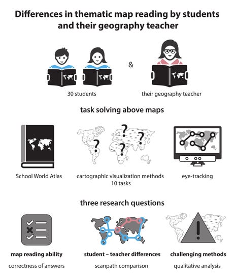
2. Methods
2.1. Experiment Design
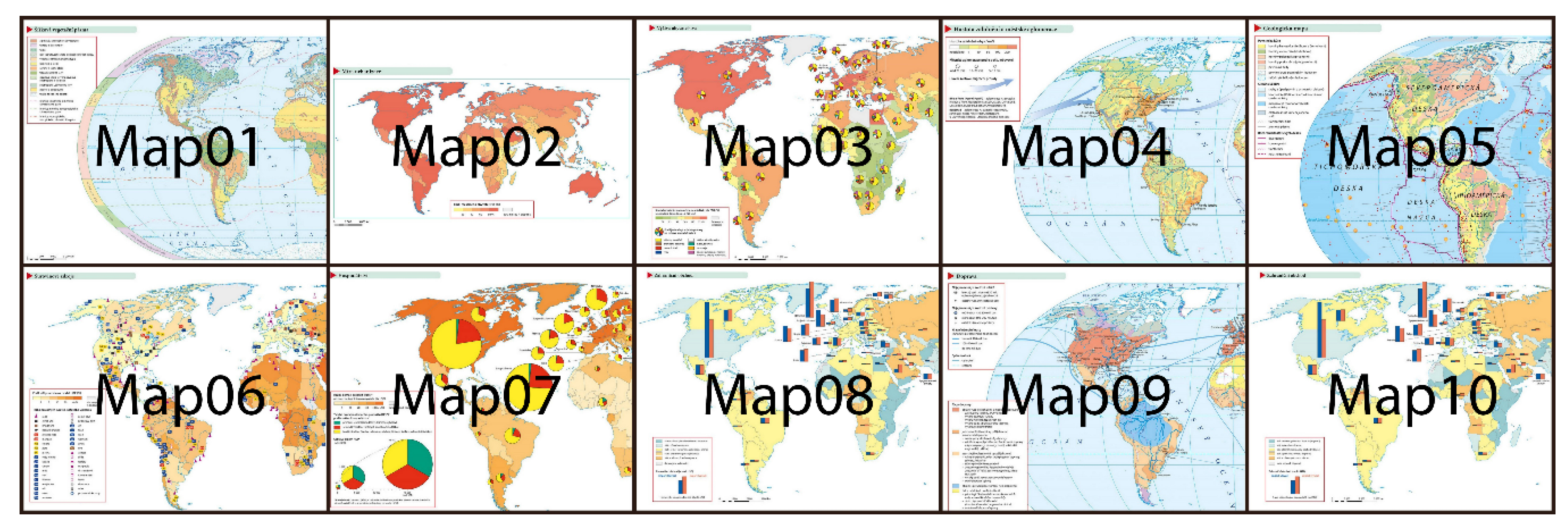
2.2. Stimuli and Tasks
2.3. Participants
2.4. Apparatus
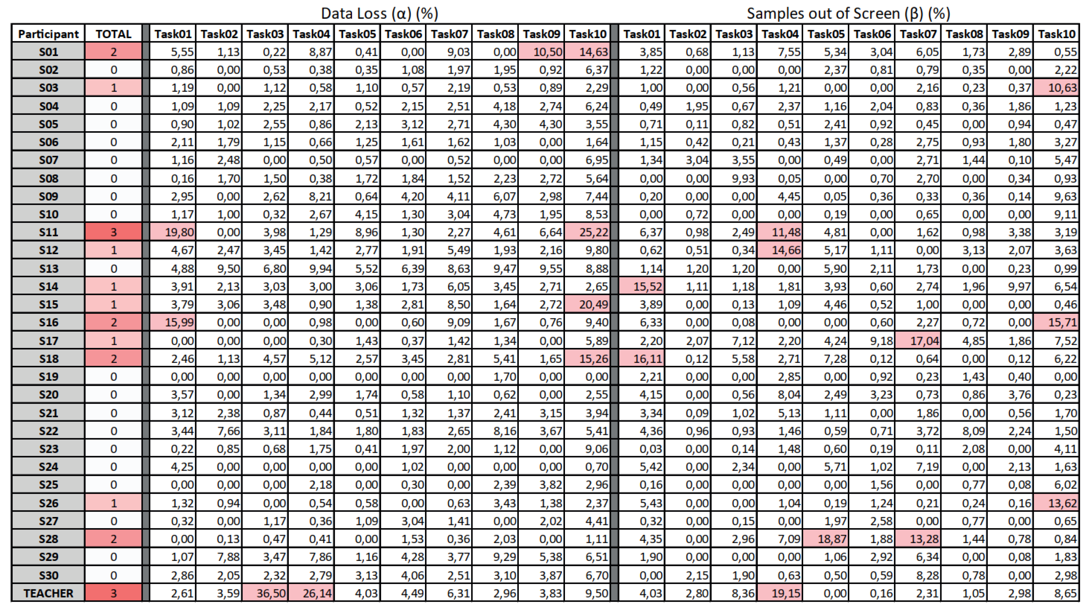
2.5. Data Pre-Processing
2.6. Methods of Analyses
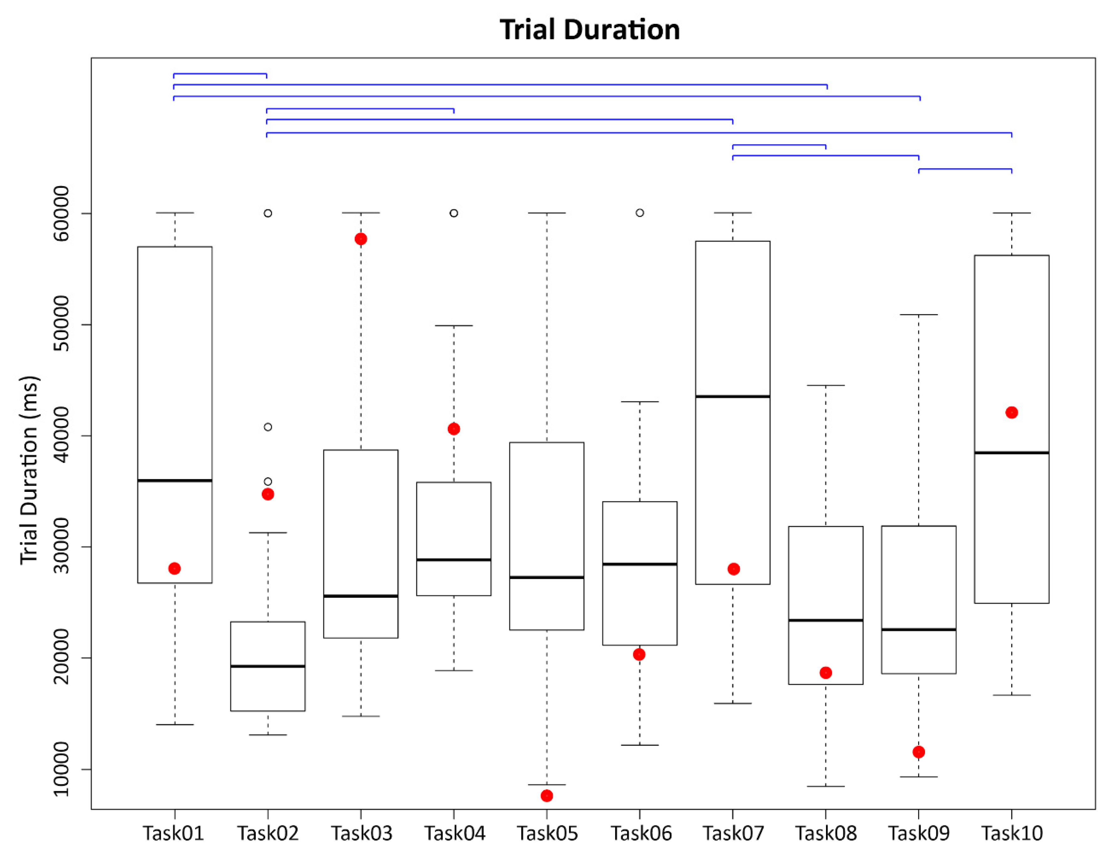
3. Results
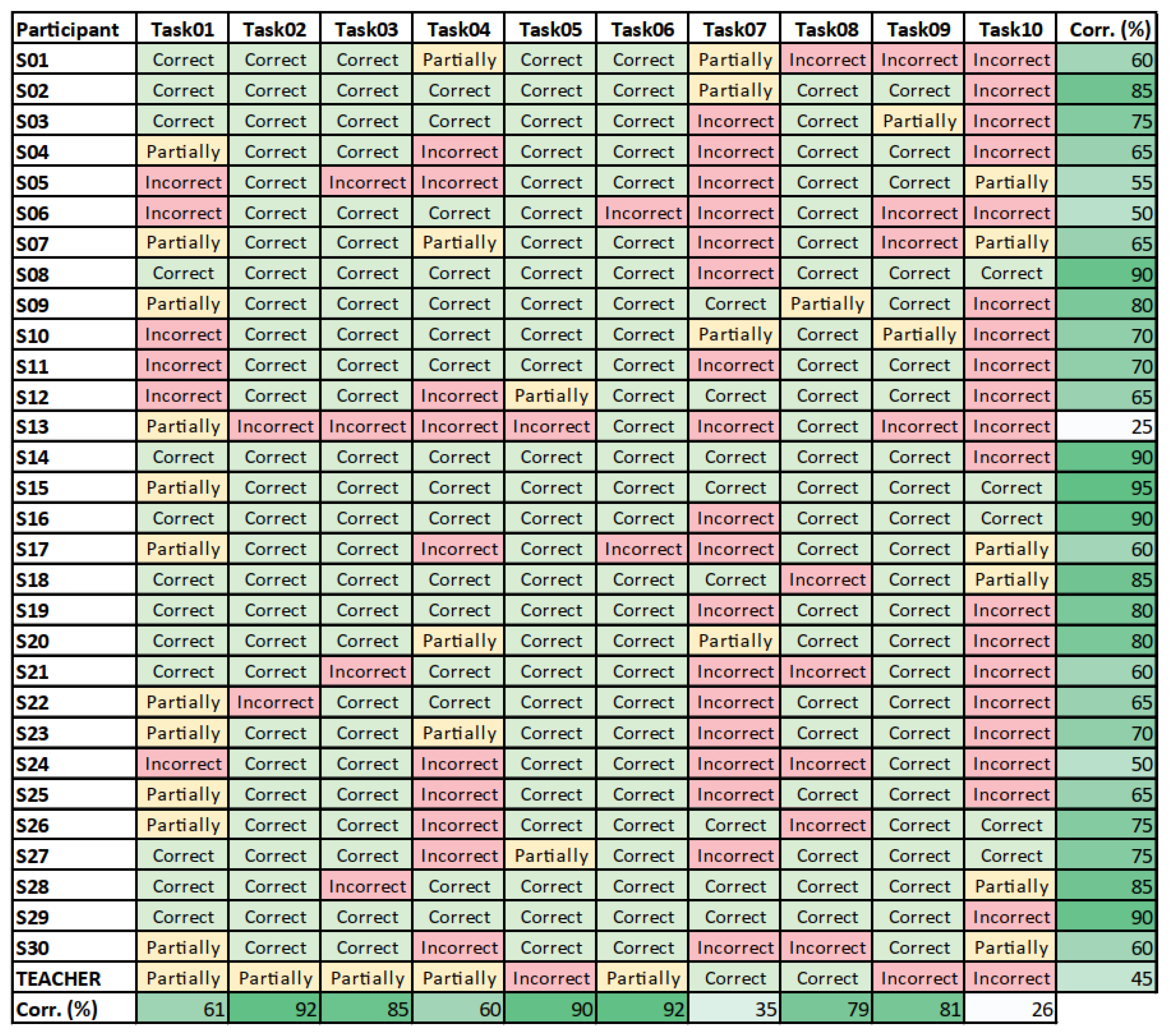
3.1. Correctness of Answers—Students’ Ability to Learn with Maps (Q1)
3.2. Results of Individual Tasks—Comprehension of Cartographic Methods (Q2)
3.2.1. Task01
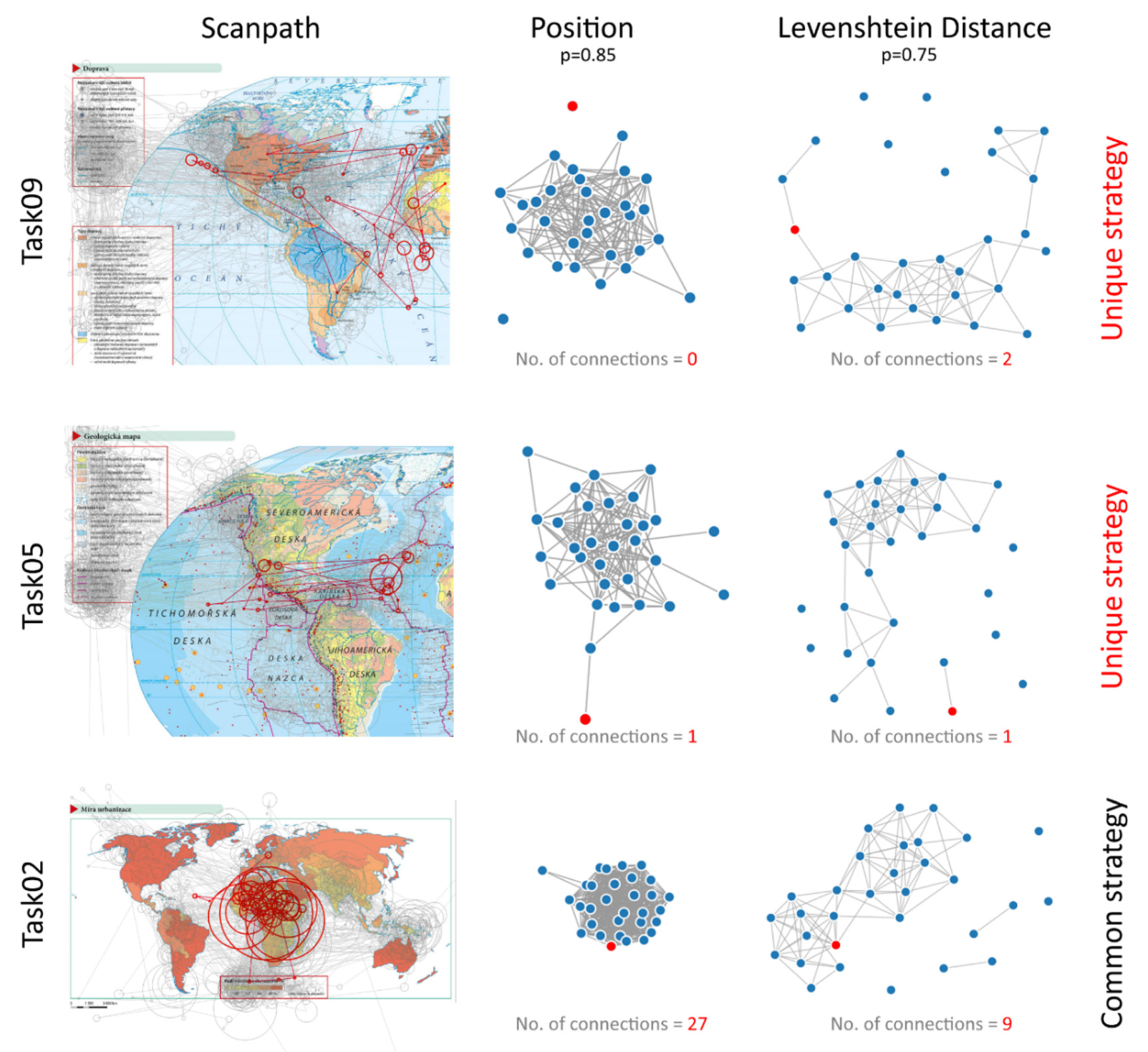
3.2.2. Task02
3.2.3. Task03
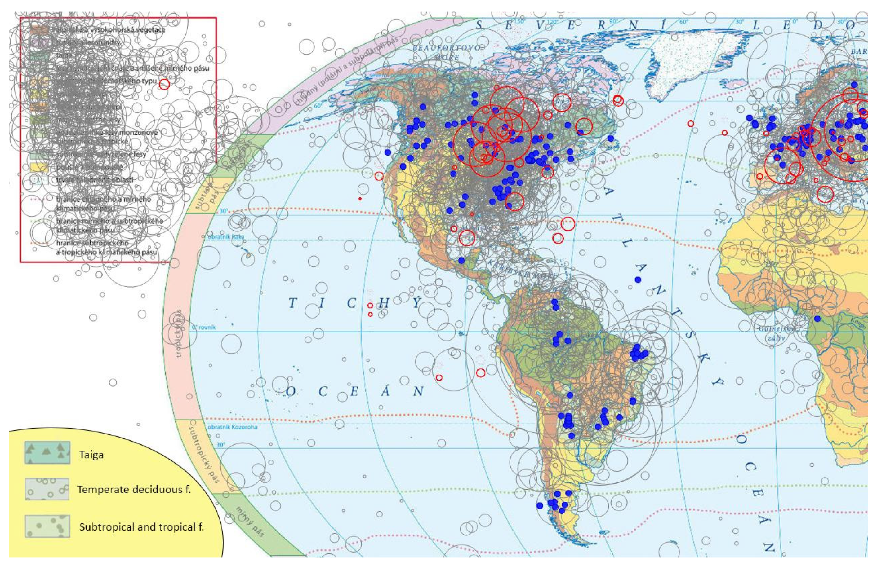
3.2.4. Task04
3.2.5. Task05
3.2.6. Task06
3.2.7. Task07
3.2.8. Task08
3.2.9. Task09
3.2.10. Task10
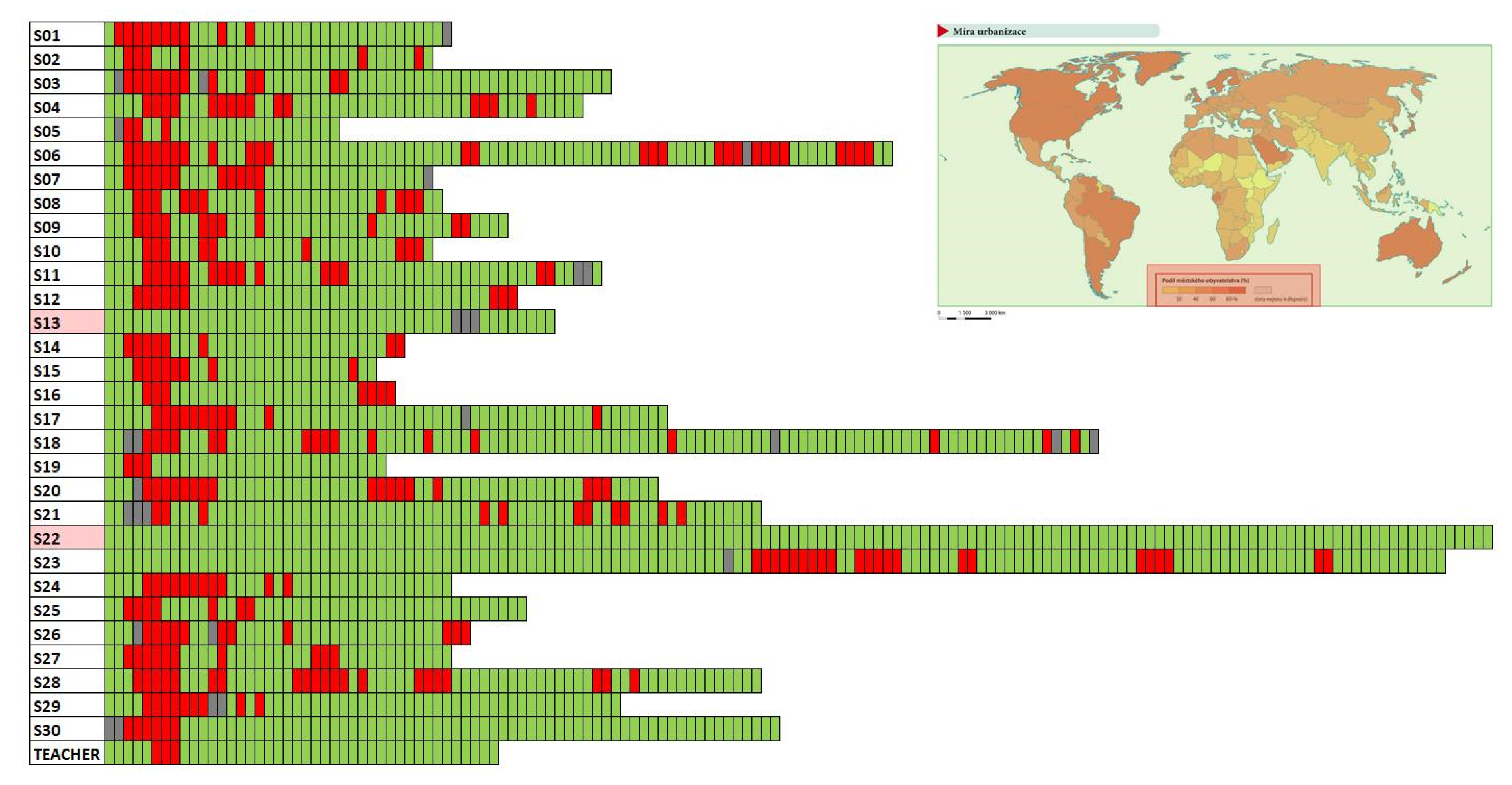
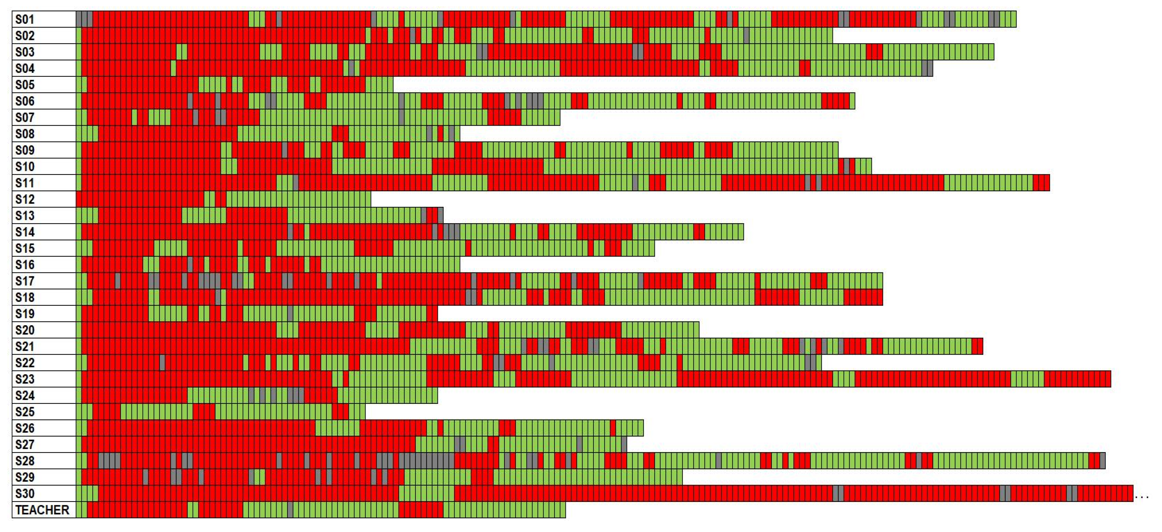
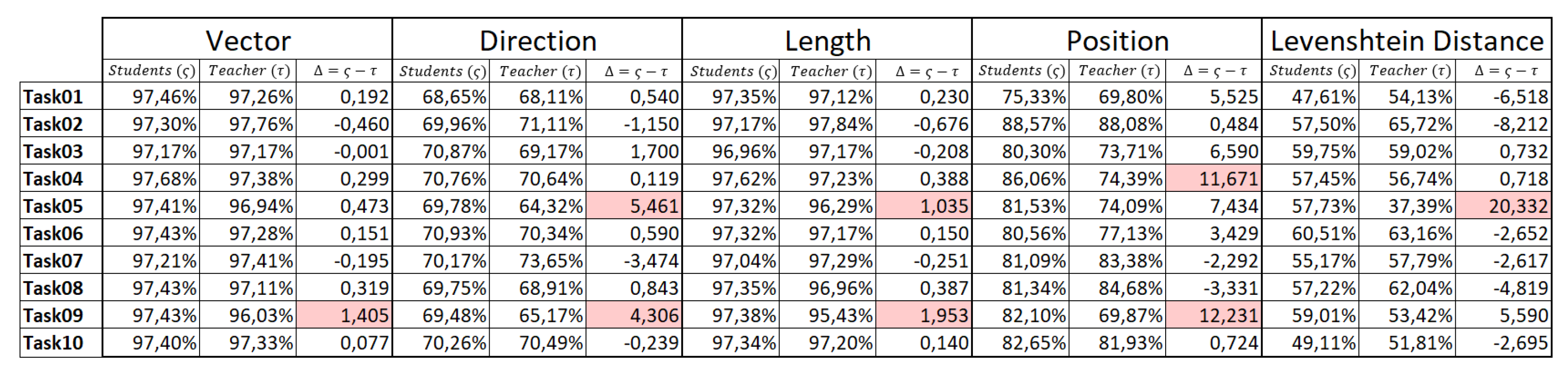
3.3. Scanpath Similarity—Difference between Students and Their Teacher (Q3)
4. Discussion
5. Conclusions
Supplementary Materials
Author Contributions
Funding
Acknowledgments
Conflicts of Interest
References
- Pravda, J. Kartografická gramotnost, čítanie máp a generovanie poznatkov z máp. Geod. A Kartogr. Obz. 2001, 47, 8–9. [Google Scholar]
- Pravda, J.; Kusendová, D. Počítačová Tvorba Tematických Máp; Univerzita Komenského Bratislava: Bratislava, Slovakia, 2004. [Google Scholar]
- Vondráková, A.; Voženílek, V. User preferences in image map using. Int. Arch. Photogramm. Remote Sens. Spat. Inf. Sci. 2016, XLI-B4, 599–603. [Google Scholar] [CrossRef] [Green Version]
- Muehrcke, P.; Kimerling, A.; Juliana, O. Muehrcke. Map Use: Reading, Analysis, and Interpretation; Revised 4th Edition; JP Publications: Madison, WI, USA, 2001. [Google Scholar]
- Olson, J.M. A coordinated approach to map communication improvement. Am. Cartogr. 1976, 3, 151–160. [Google Scholar] [CrossRef]
- Board, C. Map reading tasks appropriate in experimental studies in cartographic communication. Cartogr. Int. J. Geogr. Inf. Geovisualization 1978, 15, 1–12. [Google Scholar] [CrossRef]
- Morrison, J.L. Towards a functional definition of the science of cartography with emphasis on map reading. Am. Cartogr. 1978, 5, 97–110. [Google Scholar] [CrossRef]
- Ormeling, F. Teaching map use concepts to children. In Proceedings of the Seminar on Cognitive Map, Children and Education in Cartography, Gifu, Japan, 8–10 November 1996. [Google Scholar]
- Havelková, L.; Hanus, M. The impact of map type on the level of student map skills. Cartogr. Int. J. Geogr. Inf. Geovisualization 2018, 53, 149–170. [Google Scholar] [CrossRef]
- Hanus, M.; Marada, M. What does a map-skills-test tell us about Czech pupils? Geografie 2016, 121, 279–299. [Google Scholar] [CrossRef] [Green Version]
- Wiegand, P. Learning and Teaching with Maps; Routledge: London, UK, 2006. [Google Scholar]
- Herrmann, D.; Pickle, L.W. A cognitive subtask model of statistical map reading. Vis. Cogn. 1996, 3, 165–190. [Google Scholar] [CrossRef]
- Keates, J.S. Understanding Maps; Routledge: London, UK, 2014. [Google Scholar]
- Kimerling, A.J.; Muehrcke, P.; Muehrcke, J.O.; Muehrcke, P. Map Use: Reading, Analysis, Interpretation; ESRI Press Academic: Redlands, CA, USA, 2016. [Google Scholar]
- Robinson, A.H.; Kimerling, A. Elements of Cartography; John Wiley & Sons: Hoboken, NJ, USA, 1995. [Google Scholar]
- Bugdayci, I.; Bildirici, I.O. Evaluation of Educational Atlas Maps in Terms of Cartographic Design. In Proceedings of the IOP Conference Series: Earth and Environmental Science, Prague, Czech Republic, 5–9 September 2016; pp. 1–6. [Google Scholar]
- Brychtova, A.; Popelka, S.; Vozenilek, V.; Svobodova, H. The analysis of eye movement as a tool for evaluation of maps and graphical outputs from GIS. In Proceedings of the 19th International Conference on Geography and Geoinformatics: Challenge For Practise and Education, Brno, Czech Republic, 8–9 September 2011; pp. 154–162. [Google Scholar]
- Carswell, R.J. Children’s Abilities in Topographic Map Reading; Cartographica: Toronto, ON, Canada, 1970. [Google Scholar]
- Van Dijk, H.; van der Schee, J.; Trimp, H.; van der Zijpp, T. Map skills and geographical knowledge. Int. Res. Geogr. Environ. Educ. 1994, 3, 68–80. [Google Scholar] [CrossRef]
- Schee, J.V.D.; Dijk, H.V. The effect of student freedom of choice in learning map skills. Int. Res. Geogr. Environ. Educ. 1999, 8, 256–267. [Google Scholar] [CrossRef]
- Hanus, M.; Marada, M. Mapové dovednosti v českých a zahraničních kurikulárních dokumentech: Srovnávací studie. Geografie 2013, 118, 158–178. [Google Scholar] [CrossRef] [Green Version]
- Reyes Nuñez, J.J.; Juliarena de Moretti, C.E.; Gallé, E.; Garra, A.M.; Rey, C.A.; Alves de Castro, M.V.; Dibiase, A.S. Reading Thematic Maps in Argentine and Hungarian Schools. In Proceedings of the Read at Proceedings of the XXII International Cartographic Conference, A Coruña, Spain, 11–16 July 2005; pp. 1–10. [Google Scholar]
- Reyes Nuñez, J.J.; Juhász, B. Hungarian survey on the use of cartograms in school cartography. Int. J. Cartogr. 2015, 1, 5–17. [Google Scholar] [CrossRef]
- Sun, H.; Li, Z. Effectiveness of cartogram for the representation of spatial data. Cartogr. J. 2010, 47, 12–21. [Google Scholar] [CrossRef]
- Kubíček, P.; Šašinka, Č.; Stachoň, Z.; Štěrba, Z.; Apeltauer, J.; Urbánek, T. Cartographic Design and Usability of Visual Variables for Linear Features. Cartogr. J. 2017, 54, 91–102. [Google Scholar] [CrossRef]
- Gołębiowska, I. Legend layouts for thematic maps: A case study integrating usability metrics with the thinking aloud method. Cartogr. J. 2015, 52, 28–40. [Google Scholar] [CrossRef]
- Pétera, B.-S.; Dulamăb, M.E.; Ilovanc, O.-R.; Kosinszkid, S.-A.; Răcășane, B.S. Exploring Map Drawing Skills of Geography Teacher Training Students. Eur. Proc. Soc. Behav. Sci. 2016, 12, 41–47. [Google Scholar]
- Słomska, K. Types of maps used as a stimuli in cartographical empirical research. Misc. Geogr. 2018, 22, 157–171. [Google Scholar] [CrossRef] [Green Version]
- Bishop, B.W.; Haggerty, K.C.; Richardson, B.E. Usability of E-government mapping applications: Lessons learned from the US National Atlas. Int. J. Cartogr. 2015, 1, 134–150. [Google Scholar] [CrossRef]
- Voženílek, V.; Morkesová, P.; Vondráková, A. Cognitive aspects of map symbology in the world school atlases. Procedia-Soc. Behav. Sci. 2014, 112, 1121–1136. [Google Scholar]
- Michaelidou, E.; Nakos, B.; Filippakopoulou, V. The ability of elementary school children to analyse general reference and thematic maps. Cartogr. Int. J. Geogr. Inf. Geovisualization 2004, 39, 65–88. [Google Scholar] [CrossRef] [Green Version]
- Blaha, J.D. Hodnocení kartografických děl z hlediska estetiky a uživatelské vstřícnosti. Kartogr. Listy 2005, 13, 14–24. [Google Scholar]
- Bláha, M.J.D. Hodnocení současných českých školních atlasů světa z hlediska estetiky a uživatelské vstřícnosti. In Proceedings of the 1st International Trade Fair of Geodesy, Cartography, Navigation and Geoinformatics, Prague, Czech, 16–18 March 2006. [Google Scholar]
- Peresadko, V.; Baltabaeva, Z. Local lore school atlas of Turkmenistan as the result of foreign students’ scientific research. Probl. Bezperervnoï Geogr. Osvìti Ì Kartogr. 2017, 2017, 55–61. [Google Scholar]
- Gómez Solórzano, L.S.; Sancho Comíns, J.; Bosque Sendra, J. Atlas Design: A Usability Approach for the Development and Evaluation of Cartographic Products. Cartogr. J. 2017, 54, 343–357. [Google Scholar] [CrossRef]
- Song, Y.; Li, Q.; Yu, Y.; Xu, G.; Liu, Y.; Liu, Y. Adaptability of atlas symbol sizes under multivariate conditions. Cartogr. Geogr. Inf. Sci. 2020, 47, 1–13. [Google Scholar] [CrossRef]
- Zhang, H.; Chen, Y. Research on Design and Compilation of “The Tourist Atlas of Shanxi Province”. In Proceedings of the 2008 International Workshop on Education Technology and Training & 2008 International Workshop on Geoscience and Remote Sensing, Shanghai, China, 21–22 December 2008; pp. 263–266. [Google Scholar]
- Żyszkowska, W. Map perception: Theories and research in the second half of the twentieth century. Pol. Cartogr. Rev. 2015, 47, 179–190. [Google Scholar] [CrossRef] [Green Version]
- Rohrer, C. When to Use Which User-Experience Research Methods. Available online: https://www.nngroup.com/articles/which-ux-research-methods/ (accessed on 19 August 2020).
- Popelka, S.; Vozenilek, V. Specifying of Requirements for Spatio-Temporal Data in Map by Eye-Tracking and Space-Time-Cube. In Proceedings of the International Conference on Graphic and Image Processing, Singapore, 5–7 October 2012; Volume 8768. [Google Scholar]
- Dong, W.; Ying, Q.; Yang, Y.; Tang, S.; Zhan, Z.; Liu, B.; Meng, L. Using Eye Tracking to Explore the Impacts of Geography Courses on Map-based Spatial Ability. Sustainability 2019, 11, 76. [Google Scholar] [CrossRef] [Green Version]
- Biland, J.; Çöltekin, A. An empirical assessment of the impact of the light direction on the relief inversion effect in shaded relief maps: NNW is better than NW. Cartogr. Geogr. Inf. Sci. 2017, 44, 1–15. [Google Scholar] [CrossRef]
- Havelková, L.; Gołębiowska, I.M. What Went Wrong for Bad Solvers during Thematic Map Analysis? Lessons Learned from an Eye-Tracking Study. ISPRS Int. J. Geo-Inf. 2020, 9, 9. [Google Scholar]
- Kiik, A.; Nyström, M.; Harrie, L. Cartographic Design Matters–A Comparison of Thematic Polygon Design. Cartogr. J. 2017, 54, 24–35. [Google Scholar] [CrossRef]
- Göbel, F.; Kiefer, P.; Giannopoulos, I.; Duchowski, A.T.; Raubal, M. Improving map reading with gaze-adaptive legends. In Proceedings of Proceedings of the 2018 ACM Symposium on Eye Tracking Research & Applications, Warsaw, Poland, 14–17 June 2018; pp. 1–9. [Google Scholar]
- Burian, J.; Popelka, S.; Beitlova, M. Evaluation of the Cartographical Quality of Urban Plans by Eye-Tracking. ISPRS Int. J. Geo-Inf. 2018, 7, 192. [Google Scholar] [CrossRef] [Green Version]
- Dvorský, J.; Snášel, V.; Voženílek, V. Map similarity testing using matrix decomposition. In Proceedings of the 2009 International Conference on Intelligent Networking and Collaborative Systems, Barcelona, Spain, 4–6 November 2009; pp. 290–294. [Google Scholar]
- Anderson, K.C.; Leinhardt, G. Maps as representations: Expert novice comparison of projection understanding. Cogn. Instr. 2002, 20, 283–321. [Google Scholar] [CrossRef]
- Thorndyke, P.W.; Stasz, C. Individual differences in procedures for knowledge acquisition from maps. Cogn. Psychol. 1980, 12, 137–175. [Google Scholar] [CrossRef]
- Gilhooly, K.J.; Wood, M.; Kinnear, P.R.; Green, C. Skill in map reading and memory for maps. Q. J. Exp. Psychol. Sect. A 1988, 40, 87–107. [Google Scholar] [CrossRef]
- Herman, L.; Juřík, V.; Stachoň, Z.; Vrbík, D.; Russnák, J.; Řezník, T. Evaluation of User Performance in Interactive and Static 3D Maps. ISPRS Int. J. Geo-Inf. 2018, 7, 415. [Google Scholar] [CrossRef] [Green Version]
- Ooms, K.; De Maeyer, P.; Fack, V.; Van Assche, E.; Witlox, F. Interpreting maps through the eyes of expert and novice users. Int. J. Geogr. Inf. Sci. 2012, 26, 1773–1788. [Google Scholar] [CrossRef]
- Ooms, K.; De Maeyer, P.; Fack, V. Study of the attentive behavior of novice and expert map users using eye tracking. Cartogr. Geogr. Inf. Sci. 2014, 41, 37–54. [Google Scholar] [CrossRef] [Green Version]
- Koláčný, A. Cartographic information—A fundamental concept and term in modern cartography. Cartogr. J. 1969, 6, 47–49. [Google Scholar] [CrossRef]
- Morrison, J.L. The science of cartography and its essential processes. Cartogr. Int. J. Geogr. Inf. Geovisualization 1977, 14, 58–71. [Google Scholar] [CrossRef]
- MacEachren, A.M. How Maps Work: Representation, Visualization, and Design; Guilford Press: New York, NY, USA, 2004. [Google Scholar]
- Klimová, E. Školní Atlas Světa, 4th ed.; Kartografie Praha: Praha, Czech Republic, 2017. [Google Scholar]
- Dalmaijer, E. Is the low-cost EyeTribe eye tracker any good for research? PeerJ Prepr. 2014, 1–35. [Google Scholar] [CrossRef]
- Ooms, K.; Dupont, L.; Lapon, L.; Popelka, S. Accuracy and precision of fixation locations recorded with the low-cost Eye Tribe tracker in different experimental setups. J. Eye Mov. Res. 2015, 8, 1–24. [Google Scholar] [CrossRef]
- Popelka, S.; Stachoň, Z.; Šašinka, Č.; Doležalová, J. Eyetribe Tracker Data Accuracy Evaluation and Its Interconnection with Hypothesis Software for Cartographic Purposes. Comput. Intell. Neurosci. 2016, 2016. [Google Scholar] [CrossRef] [PubMed] [Green Version]
- Janthanasub, V.; Meesad, P. Evaluation of a low-cost eye tracking system for computer input. King Mongkut’s Univ. Technol. North Bangk. Int. J. Appl. Sci. Technol. 2015, 8, 185–196. [Google Scholar] [CrossRef] [Green Version]
- Lewis, G.; Bidelman, G.M. Autonomic Nervous System Correlates of Speech Categorization Revealed through Pupillometry. Front. Neurosci. 2019, 13, 1418. [Google Scholar] [CrossRef]
- Dos Santos, J.P.M.; Ferreira, H.; Reis, J.; Prata, D.; Simões, S.P.; Borges, I.D. The Use of Consumer Neuroscience Knowledge in Improving Real Promotional Media: The Case of Worten. In Marketing and Smart Technologies; Springer: Berlin/Heidelberg, Germany, 2020; pp. 202–218. [Google Scholar]
- Kim, S.; Pollanen, M.; Reynolds, M.G.; Burr, W.S. Problem Solving as a Path to Comprehension. Math. Comput. Sci. 2020, 1–15. [Google Scholar] [CrossRef]
- Skrabankova, J.; Popelka, S.; Beitlova, M. Students’ ability to work with graphs in physics studies related to three typical student groups. J. Balt. Sci. Educ. 2020, 19, 298–316. [Google Scholar] [CrossRef] [Green Version]
- Larson, D.J.; Wetherbee, J.C.; Branscum, P. CrossFit Athletic Identity’s Relationship to Sponsor Recall, Recognition, and Purchase Intent. Int. J. Kinesiol. Sports Sci. 2019, 7, 6–15. [Google Scholar] [CrossRef] [Green Version]
- Voßkühler, A.; Nordmeier, V.; Kuchinke, L.; Jacobs, A.M. OGAMA (Open Gaze and Mouse Analyzer): Open-source software designed to analyze eye and mouse movements in slideshow study designs. Behav. Res. Methods 2008, 40, 1150–1162. [Google Scholar] [CrossRef] [Green Version]
- Popelka, S. Optimal eye fixation detection settings for cartographic purposes. In Proceedings of the 14th SGEM GeoConference on Informatics, Geoinformatics and Remote Sensing, Albena, Bulgaria, 17–26 June 2014; pp. 705–712. [Google Scholar]
- Andrienko, G.; Andrienko, N.; Wrobel, S. Visual analytics tools for analysis of movement data. ACM SIGKDD Explor. Newsl. 2007, 9, 38–46. [Google Scholar] [CrossRef]
- Andrienko, G.; Andrienko, N.; Burch, M.; Weiskopf, D. Visual Analytics Methodology for Eye Movement Studies. IEEE Trans. Vis. Comput. Graph. 2012, 18, 2889–2898. [Google Scholar] [CrossRef] [Green Version]
- Dolezalova, J.; Popelka, S. ScanGraph: A Novel Scanpath Comparison Method Using Visualisation of Graph Cliques. J. Eye Mov. Res. 2016, 9, 1–13. [Google Scholar] [CrossRef]
- Popelka, S.; Dolezalova, J.; Beitlova, M. New features of scangraph: A tool for revealing participants’ strategy from eye-movement data. In Proceedings of the ACM Symposium on Eye Tracking Research & Applications, Warsaw, Poland, 14–17 June 2018; p. 103. [Google Scholar]
- Jarodzka, H.; Holmqvist, K.; Nyström, M. A vector-based, multidimensional scanpath similarity measure. In Proceedings of the 2010 Symposium on Eye-Tracking Research & Applications, Austin, TX, USA, 22–24 March 2010; pp. 211–218. [Google Scholar]
- Dewhurst, R.; Nyström, M.; Jarodzka, H.; Foulsham, T.; Johansson, R.; Holmqvist, K. It depends on how you look at it: Scanpath comparison in multiple dimensions with MultiMatch, a vector-based approach. Behav. Res. Methods 2012, 44, 1079–1100. [Google Scholar] [CrossRef] [PubMed] [Green Version]
- Wagner, A.; Halchenko, Y.; Hanke, M. multimatch-gaze: The MultiMatch algorithm for gaze path comparison in Python. J. Open Source Softw. 2019, 4, 1525. [Google Scholar] [CrossRef]
- Coltekin, A.; Fabrikant, S.; Lacayo, M. Exploring the efficiency of users’ visual analytics strategies based on sequence analysis of eye movement recordings. Int. J. Geogr. Inf. Sci. 2010, 24, 1559–1575. [Google Scholar] [CrossRef]
- Castner, N.; Kasneci, E.; Kübler, T.; Scheiter, K.; Richter, J.; Eder, T.; Hüttig, F.; Keutel, C. Scanpath comparison in medical image reading skills of dental students: Distinguishing stages of expertise development. In Proceedings of the 2018 ACM Symposium on Eye Tracking Research & Applications, Warsaw, Poland, 14–17 June 2018; pp. 1–9. [Google Scholar]
- Day, E.L.; Tang, H.; Kendhammer, L.K.; Pienta, N.J. Sequence Analysis: Use of Scanpath Patterns for Analysis of Students’ Problem-Solving Strategies. In Eye Tracking for the Chemistry Education Researcher; ACS Publications: Washington, DC, USA, 2018; pp. 73–97. [Google Scholar]
- Kang, Z.; Landry, S.J. An eye movement analysis algorithm for a multielement target tracking task: Maximum transition-based agglomerative hierarchical clustering. IEEE Trans. Hum. -Mach. Syst. 2014, 45, 13–24. [Google Scholar] [CrossRef]
- Popelka, S.; Herman, L.; Řezník, T.; Pařilová, M.; Jedlička, K.; Bouchal, J.; Kepka, M.; Charvát, K. User Evaluation of Map-Based Visual Analytic Tools. ISPRS Int. J. Geo-Inf. 2019, 8, 363. [Google Scholar] [CrossRef] [Green Version]
- Dolezalova, J.; Popelka, S. Evaluation of user strategy on 2D and 3D city maps based on novel scanpath comparison method and graph visualization. In Proceedings of the ISPRS 2016, Prague, Czech, 12–19 July 2016. [Google Scholar]
- Kulhavy, R.W.; Stock, W.A. How cognitive maps are learned and remembered. Ann. Assoc. Am. Geogr. 1996, 86, 123–145. [Google Scholar] [CrossRef]


| ID | Description of Task |
|---|---|
| Task01 | Identify all areas with temperate deciduous forests. |
| Task02 | Identify all countries with less than 20% urban populations. |
| Task03 | Identify the country with the highest proportion of potatoes in total calorie consumption. |
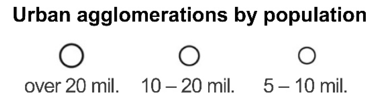
| Task04 | Identify urban agglomerations with more than 20 million inhabitants in North America, Central America, and South America. |
| Task05 | Identify a convergent plate boundary. |
| Task06 | Identify a place on every continent where iron ore is mined. |
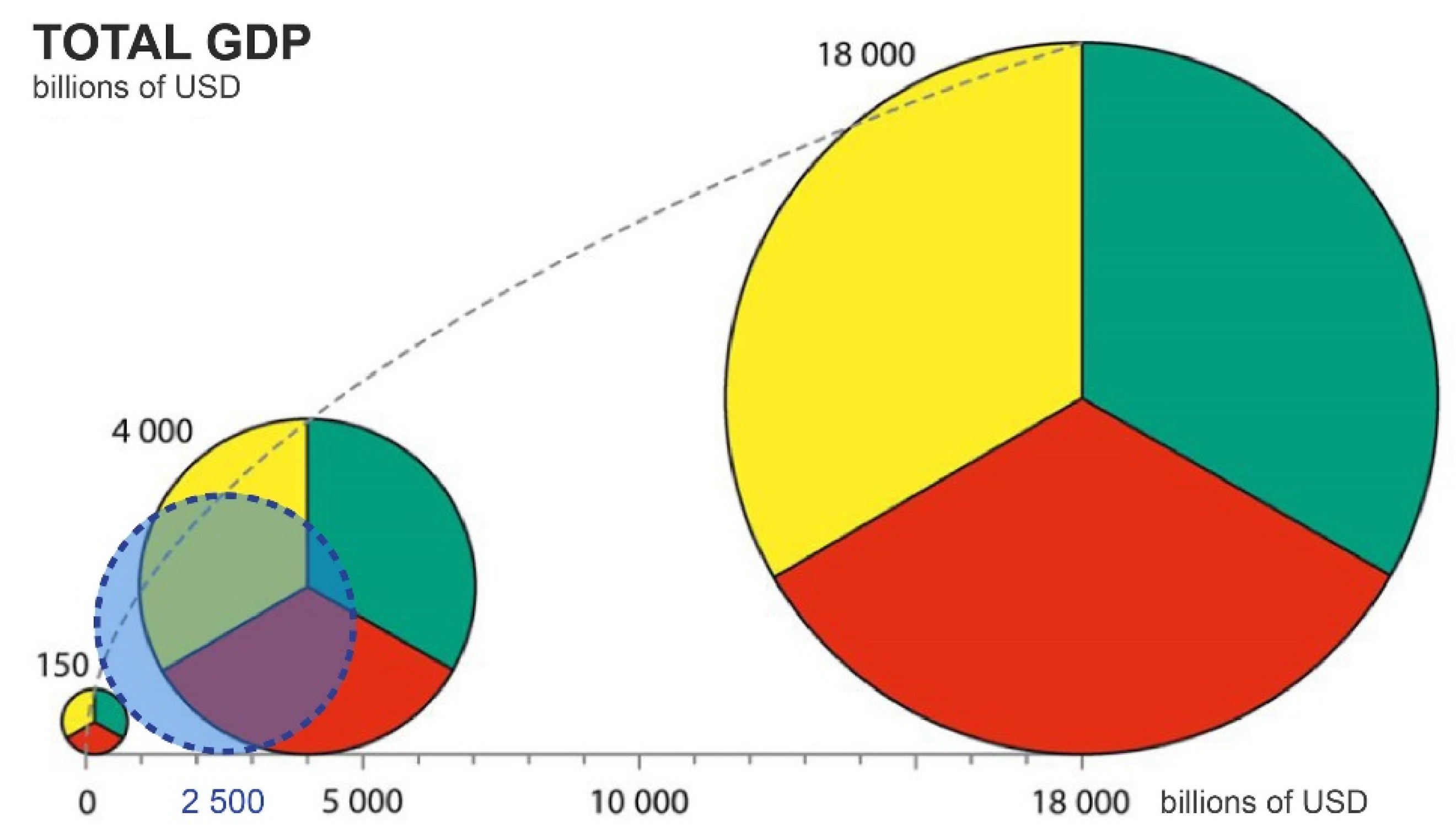
| Task07 | Identify three countries with a total GDP of approximately USD 2500 billion. |
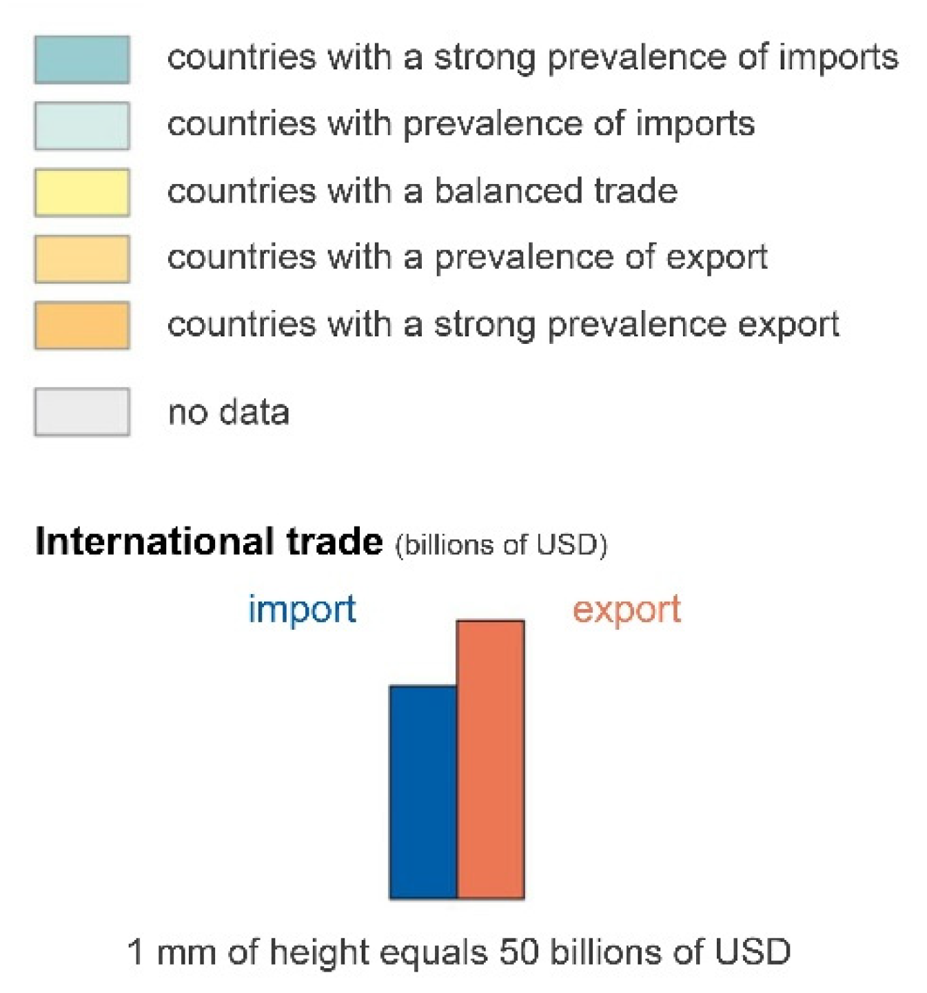
| Task08 | Identify three countries whose imports exceed exports. |
| Task09 | Identify three shipping routes with an annual capacity under 100 million tonnes. |
| Task10 | Estimate Brazil’s export volume in billions of USD. |
© 2020 by the authors. Licensee MDPI, Basel, Switzerland. This article is an open access article distributed under the terms and conditions of the Creative Commons Attribution (CC BY) license (http://creativecommons.org/licenses/by/4.0/).
Share and Cite
Beitlova, M.; Popelka, S.; Vozenilek, V. Differences in Thematic Map Reading by Students and Their Geography Teacher. ISPRS Int. J. Geo-Inf. 2020, 9, 492. https://doi.org/10.3390/ijgi9090492
Beitlova M, Popelka S, Vozenilek V. Differences in Thematic Map Reading by Students and Their Geography Teacher. ISPRS International Journal of Geo-Information. 2020; 9(9):492. https://doi.org/10.3390/ijgi9090492
Chicago/Turabian StyleBeitlova, Marketa, Stanislav Popelka, and Vit Vozenilek. 2020. "Differences in Thematic Map Reading by Students and Their Geography Teacher" ISPRS International Journal of Geo-Information 9, no. 9: 492. https://doi.org/10.3390/ijgi9090492
APA StyleBeitlova, M., Popelka, S., & Vozenilek, V. (2020). Differences in Thematic Map Reading by Students and Their Geography Teacher. ISPRS International Journal of Geo-Information, 9(9), 492. https://doi.org/10.3390/ijgi9090492