An Integrated Approach for Detection and Prediction of Greening Situation in a Typical Desert Area in China and Its Human and Climatic Factors Analysis


Abstract
:1. Introduction
2. Study Area and Data
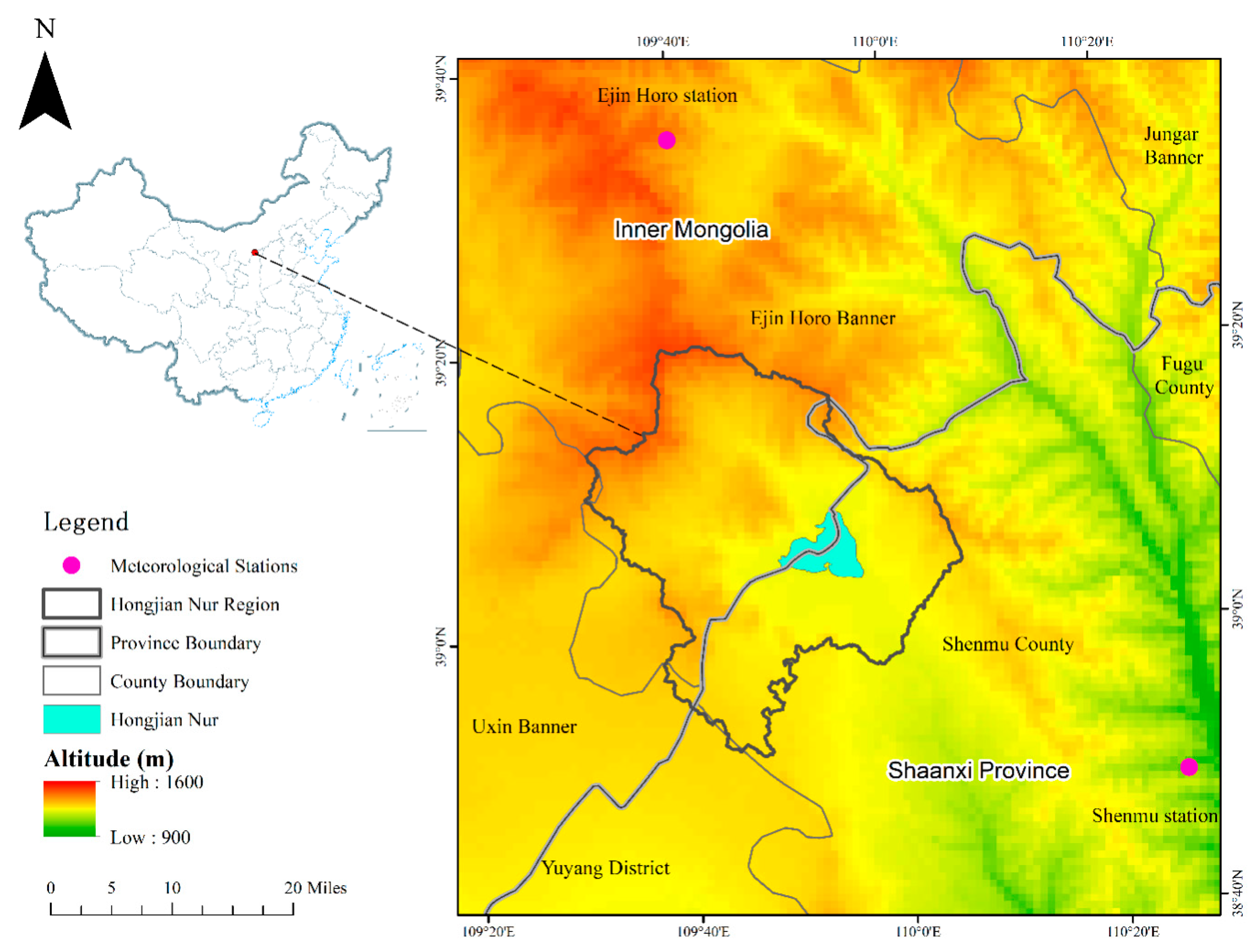
2.1. Study Area
2.2. Data
2.2.1. MODIS Data
2.2.2. Landsat Data
2.2.3. Meteorological Data
3. Methodology
3.1. VC Calculation
3.2. Land Use Analysis
3.3. VC Prediction
3.4. Statistics and Time Series Analysis
3.4.1. Zonal Statistics Method
3.4.2. The State Transition Matrix (STM)
3.4.3. Linear Regression
4. Results
4.1. VC of HJN Lake and the Surrounding Area
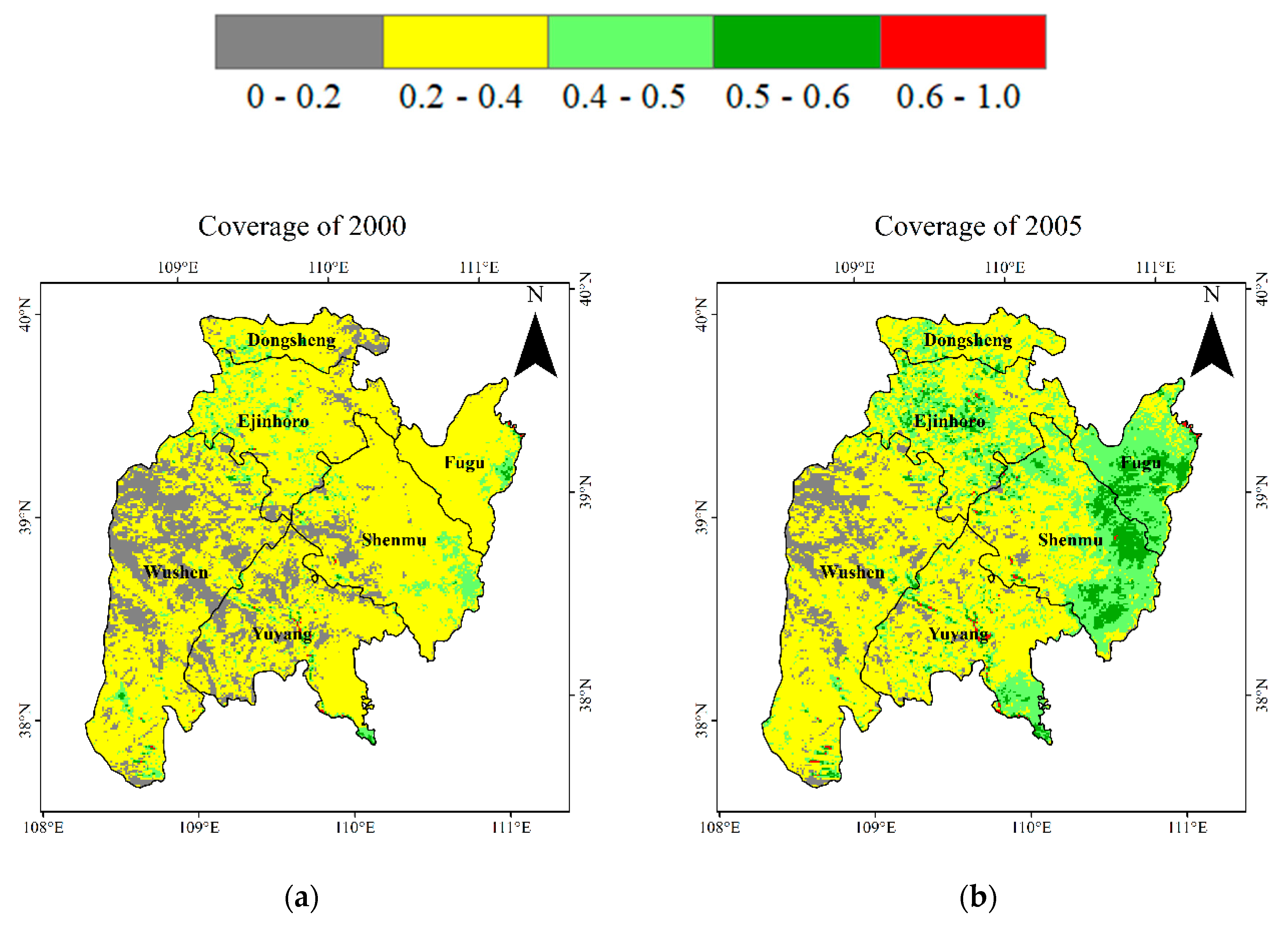
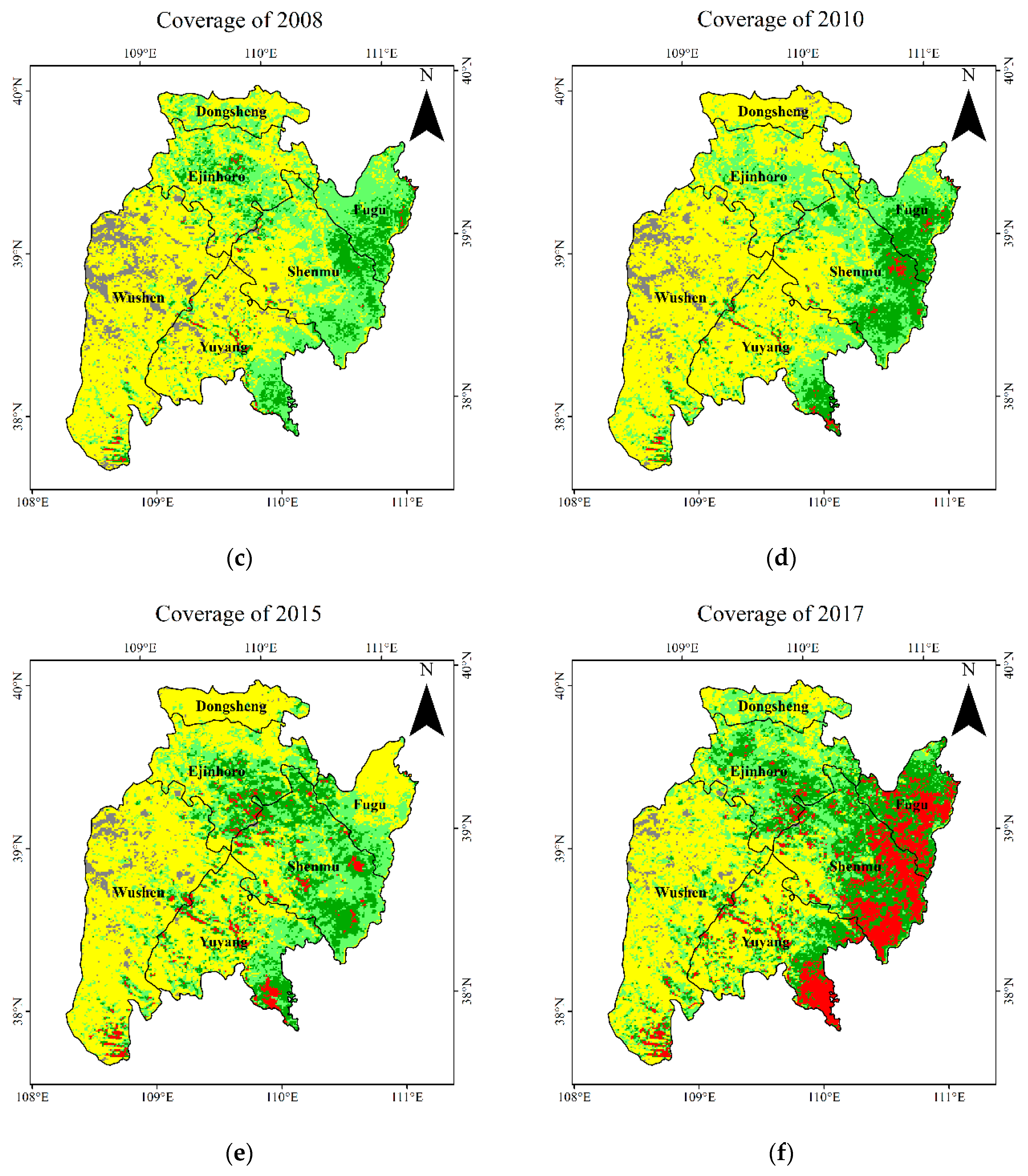
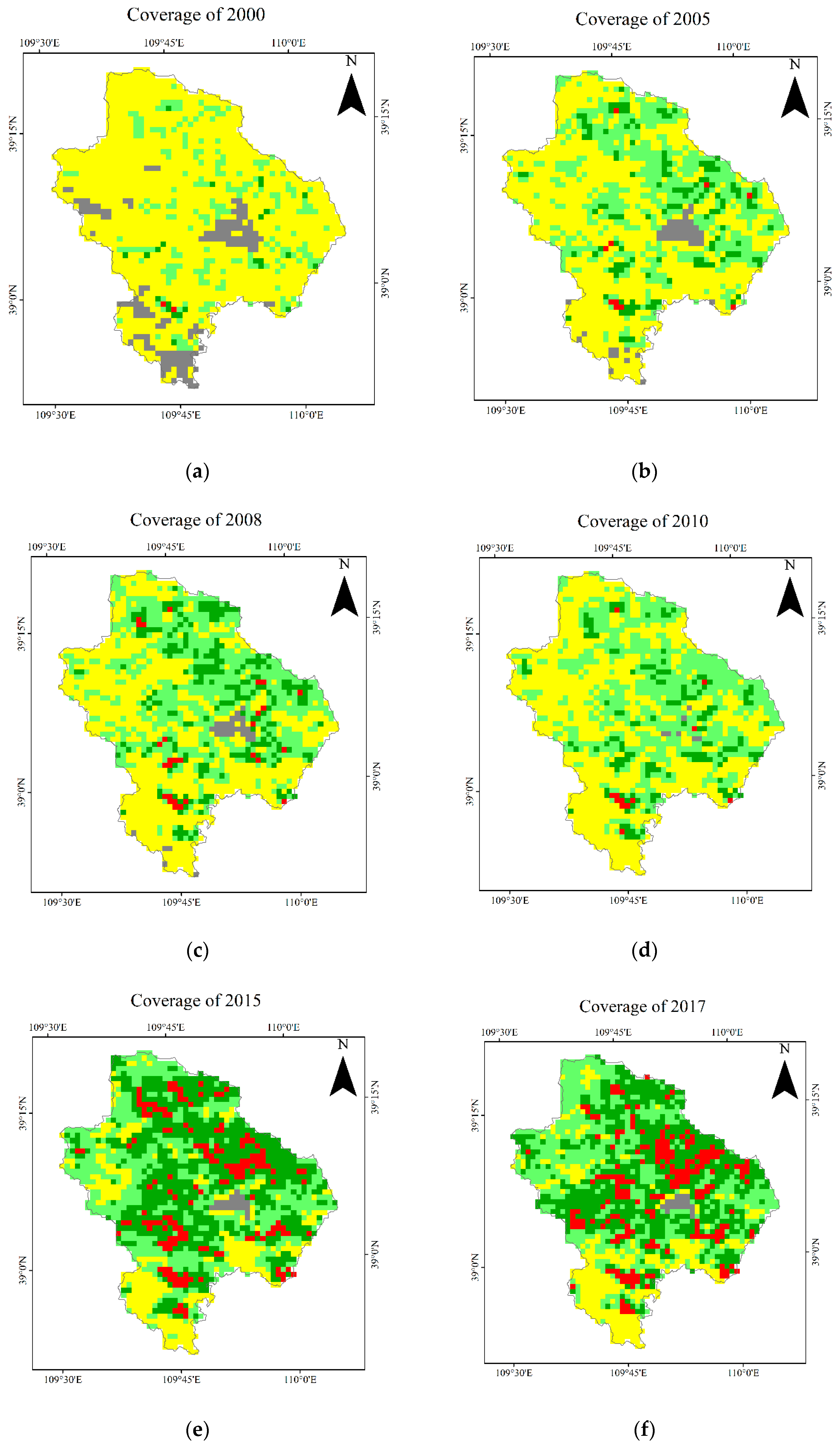
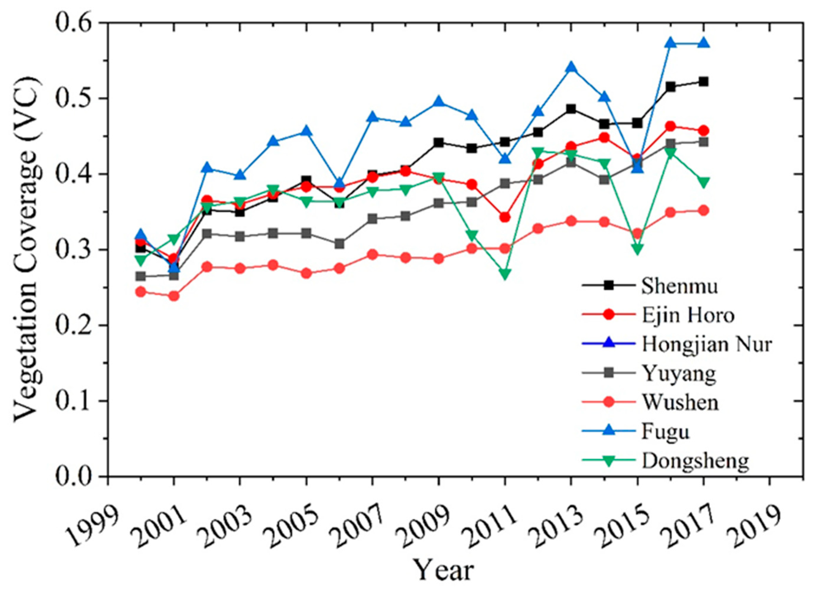
4.1.1. VC Change in the Region Surrounding HJN Lake
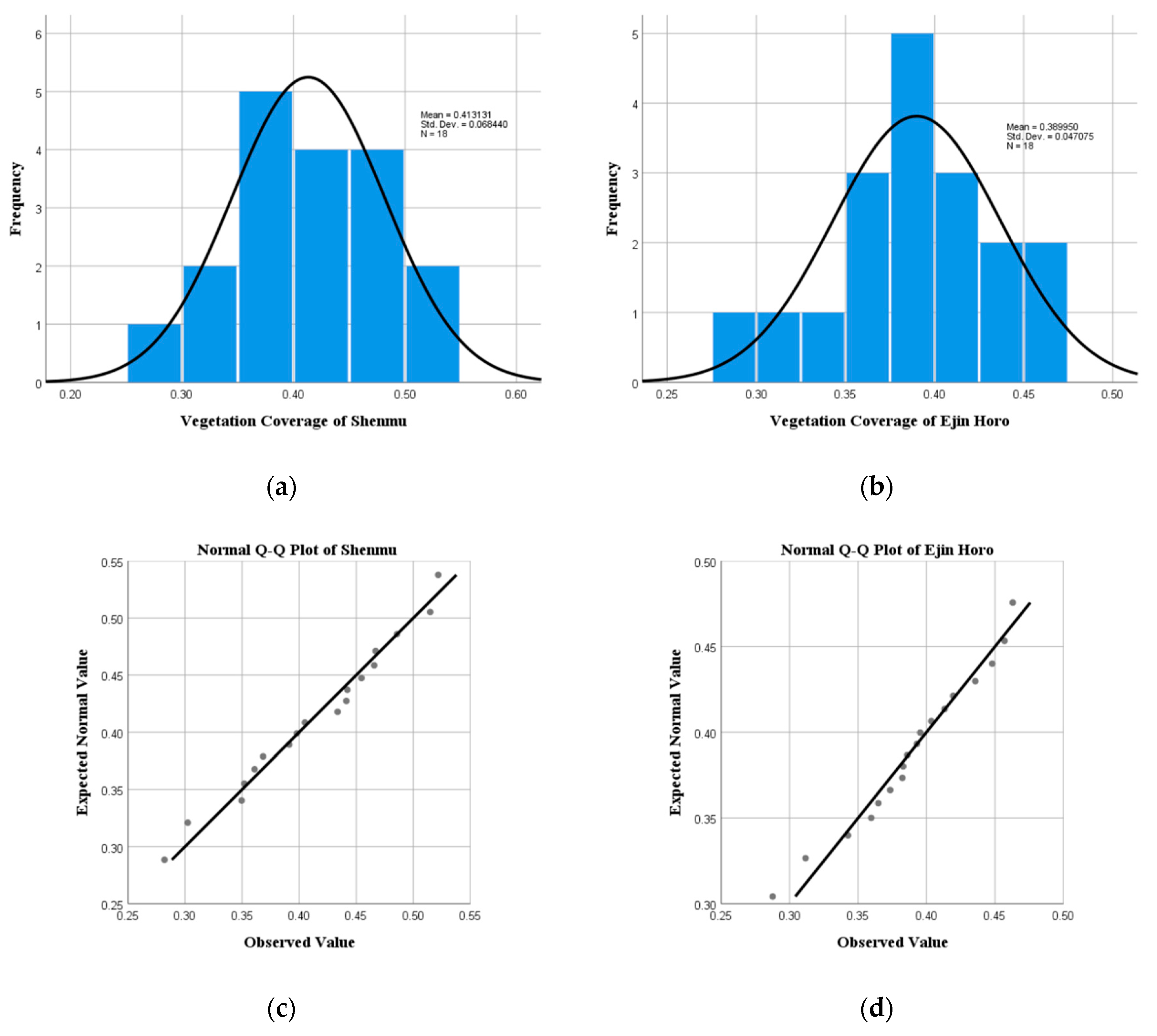
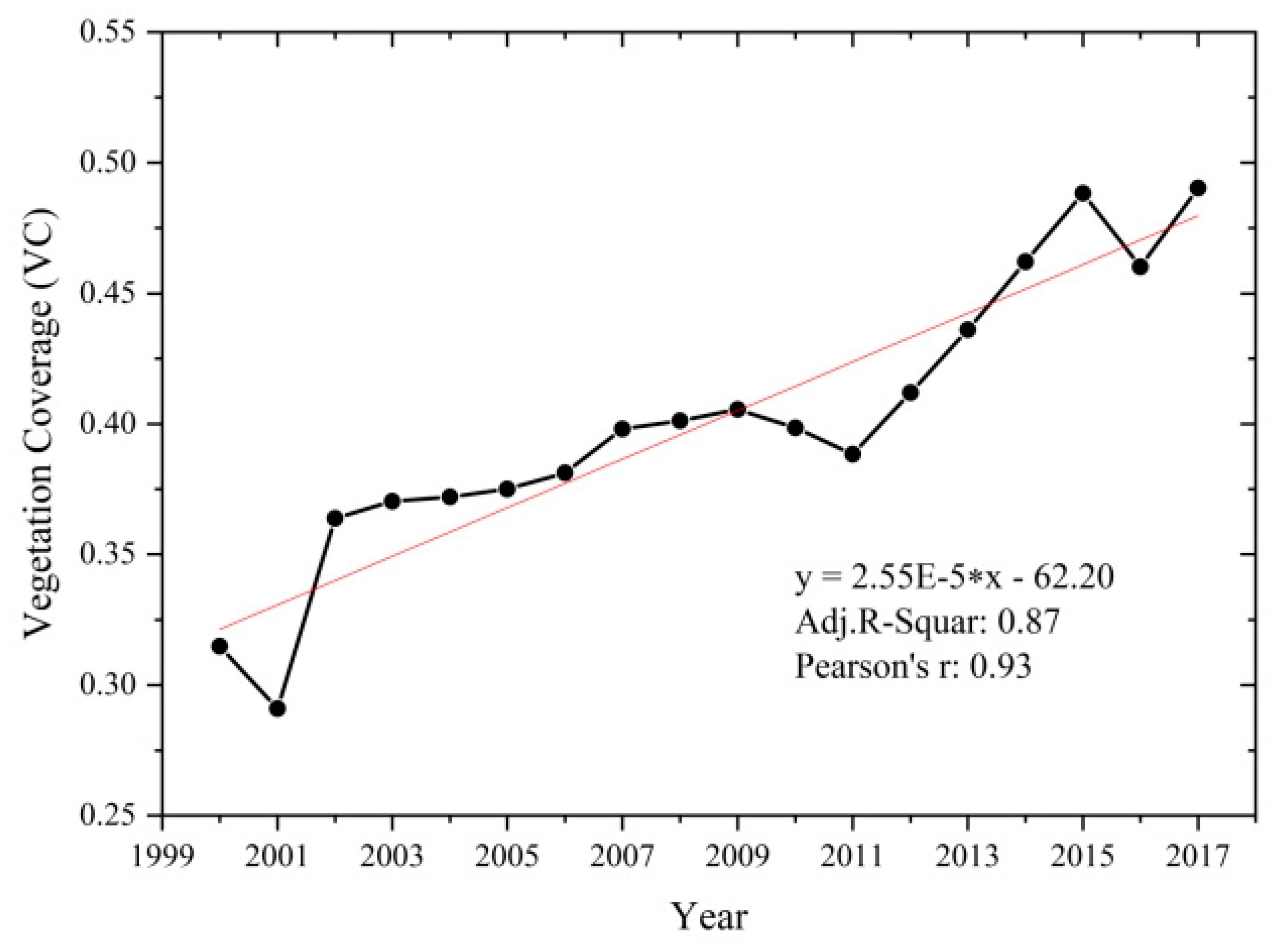
4.1.2. VC Change in HJN Watershed
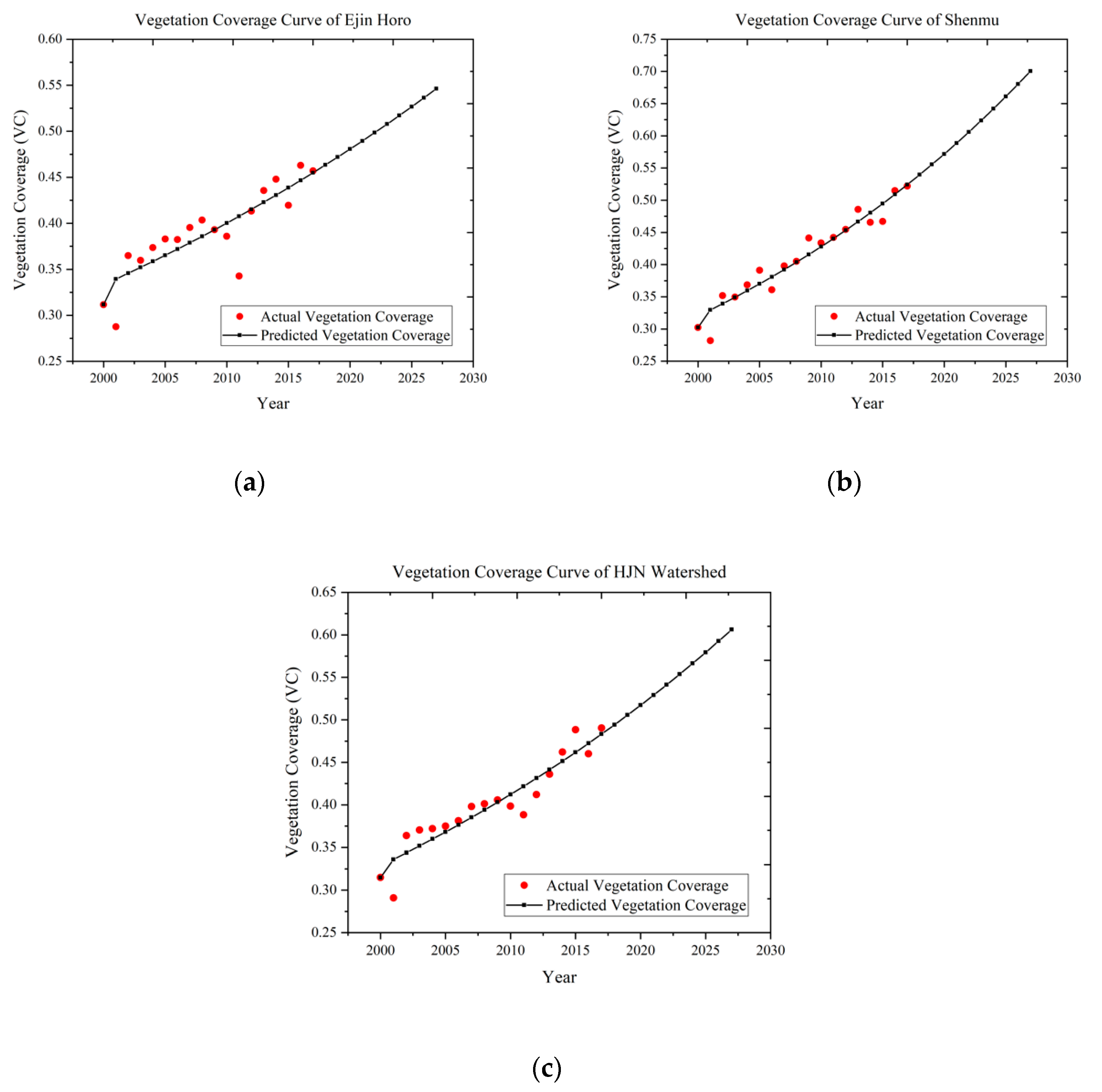
4.1.3. VC Prediction in the HJN Watershed and the Surrounding Regions
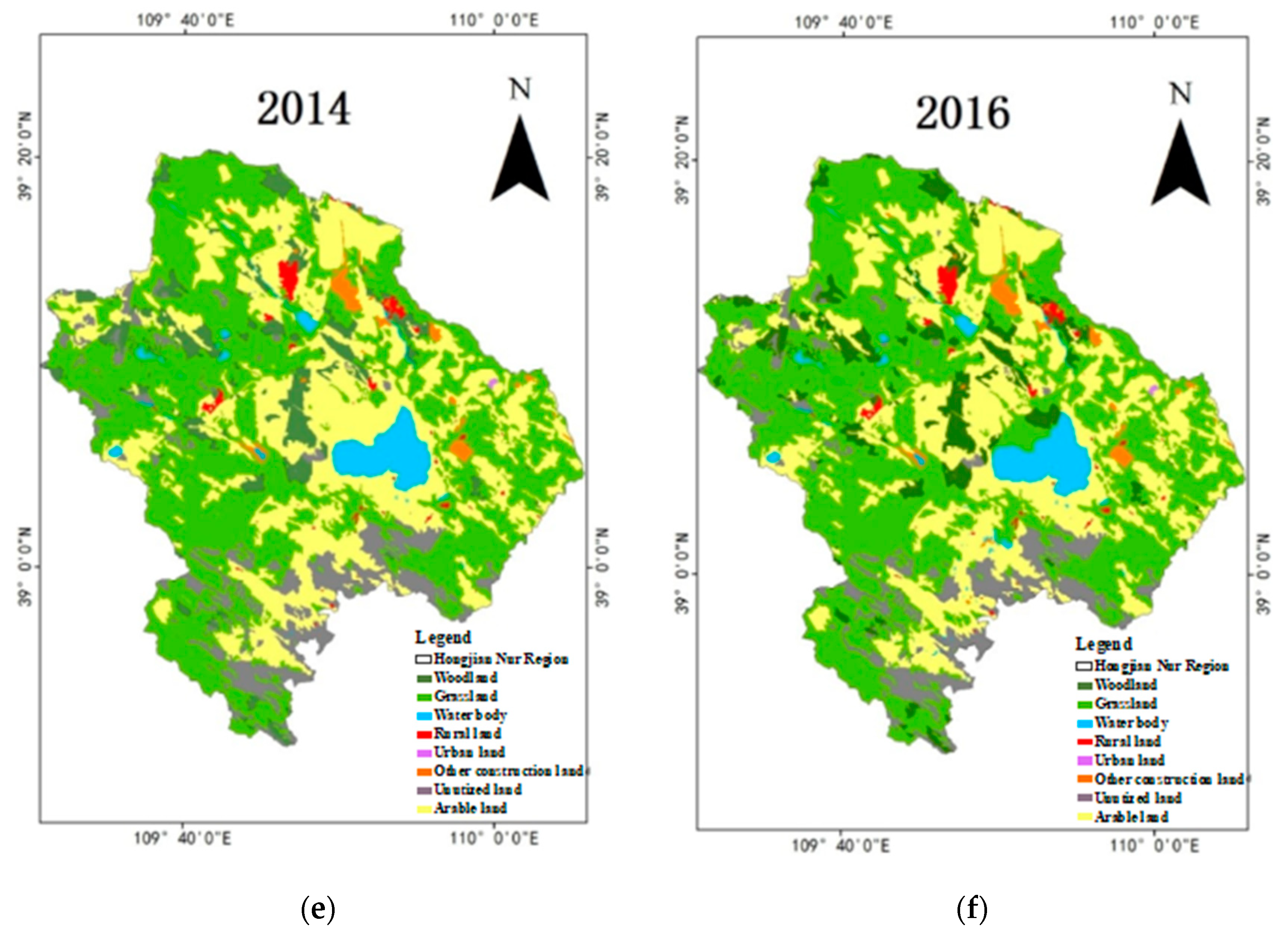
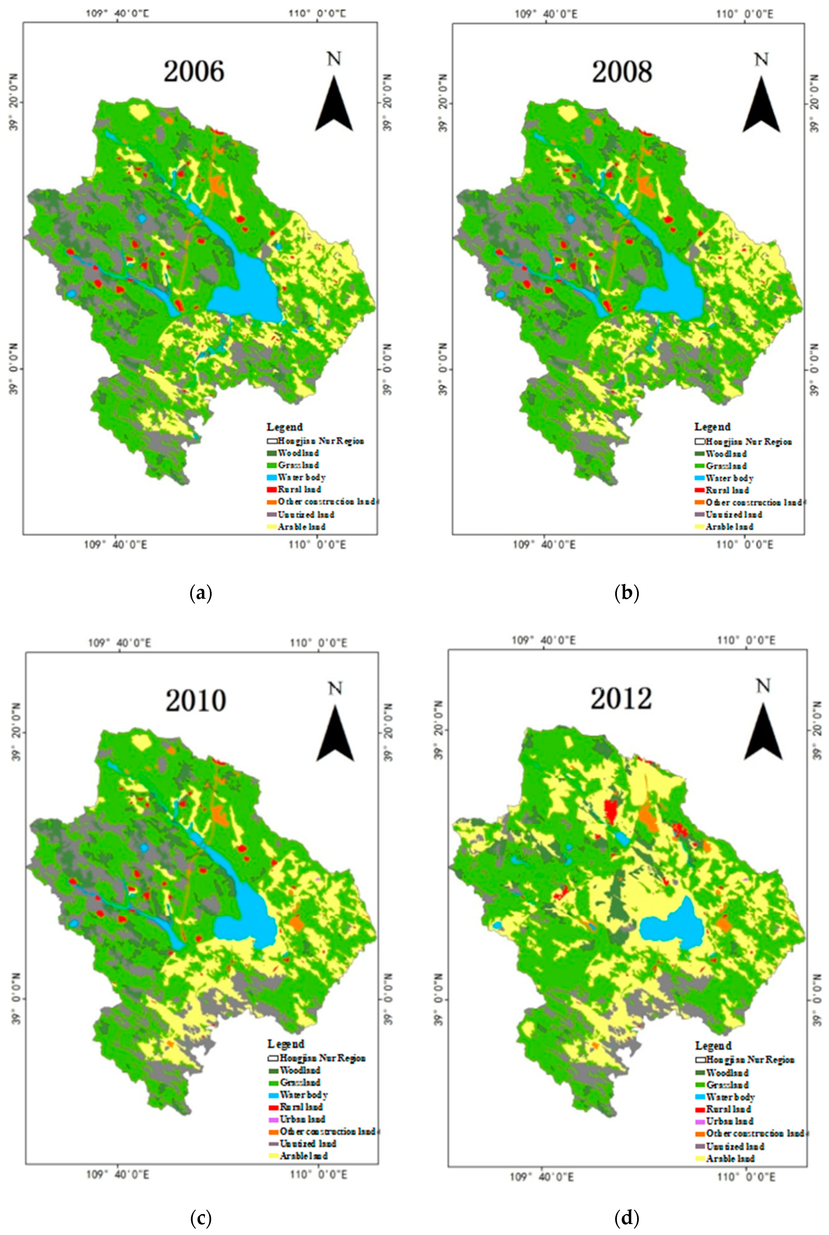
4.2. Land Use in the HJN Watershed
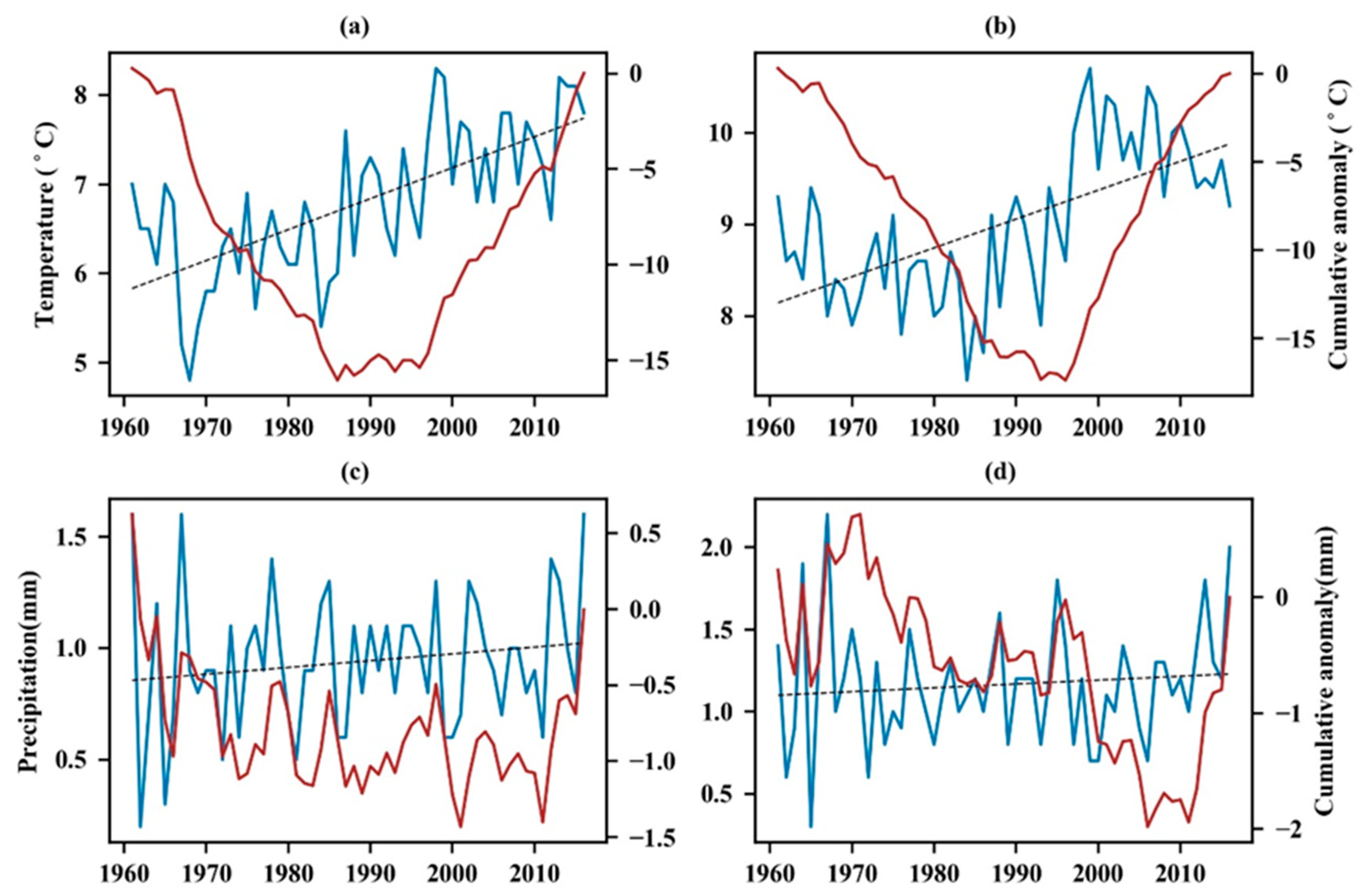
4.3. Impact of Climate Change on VC and Land Use
5. Discussion
5.1. Impact of Climate Change on VC and Land Use
5.2. Effect of Afforestation on VC in HJN Watershed
5.3. Relationship among VC, Land Use, and Lake Area
6. Conclusions
Author Contributions
Funding
Acknowledgments
Conflicts of Interest
References
- Cvetković, V.; Gačić, J.; Jakovljević, V. Impact of climate change on the distribution of extreme temperatures as natural disasters. Vojno Delo 2015, LXVII, 21–42. [Google Scholar] [CrossRef]
- Trenholm, R.; Haider, W.; Lantz, V.; Knowler, D.; Haegeli, P. Landowner preferences for wetlands conservation programs in two Southern Ontario watersheds. J. Environ. Manag. 2017, 200, 6–21. [Google Scholar] [CrossRef] [PubMed]
- Han, X.; Chen, X.; Feng, L. Four decades of winter wetland changes in Poyang Lake based on Landsat observations between 1973 and 2013. Remote Sens. Environ. 2015, 156, 426–437. [Google Scholar] [CrossRef]
- Zhang, Q.; Sun, R.; Jiang, G.; Xu, Z.; Liu, S. Carbon and energy flux from a Phragmites australis wetland in Zhangye oasis-desert area, China. Agric. Meteorol. 2016, 230–231, 45–57. [Google Scholar] [CrossRef]
- Smith, B.; Samuelsson, P.; Wramneby, A.; Rummukainen, M.J.T. A model of the coupled dynamics of climate, vegetation and terrestrial ecosystem biogeochemistry for regional applications. Tellus A 2011, 63, 87–106. [Google Scholar] [CrossRef]
- Danyar, S.; Yudong, S.; Jumakeld, M. Influence of groundwater level change on vegetation coverage and their spatial variation in arid regions. J. Geogr. Sci. 2004, 14, 323. [Google Scholar] [CrossRef]
- Fu, B.; Burgher, I. Riparian vegetation NDVI dynamics and its relationship with climate, surface water and groundwater. J. Arid Environ. 2015, 113, 59–68. [Google Scholar] [CrossRef]
- Zhu, L.; Gong, H.; Dai, Z.; Xu, T.; Su, X. An integrated assessment of the impact of precipitation and groundwater on vegetation growth in arid and semiarid areas. Environ. Earth Sci. 2015, 74, 5009–5021. [Google Scholar] [CrossRef] [Green Version]
- Elhag, A.M.H.; Ibrahim, I.S.; Dafalla, M.S. Vegetation Change Detection Using Higher Resolution Imagery in Arid Areas of the Northern State (Sudan); University of Khartoum: Khartoum, Sudan, 2016. [Google Scholar]
- Liu, B.; Tang, Z.; Dong, S.; Wang, L.; Liu, D. Vegetation recovery and groundwater pollution control of coal gangue field in a semi-arid area for a field application. Int. Biodeterior. Biodegrad. 2018, 128, 134–140. [Google Scholar] [CrossRef]
- Xiu, L.; Yan, C.; Li, X.; Qian, D.; Feng, K. Changes in wetlands and surrounding land cover in a desert area under the influences of human and climatic factors: A case study of the Hongjian Nur region. Ecol. Indic. 2019, 101, 261–273. [Google Scholar] [CrossRef]
- Qin, W.; Li, Z.; Liu, K.; Chen, Y. The new home of the relict gull-Hongjian Nur nature reserve in Shaanxi province, China. Life World 2016, 06, 84–93. [Google Scholar]
- Xiao, H.; Zhang, Z.; Wang, Z.; Wang, Y. Breeding population dynamic of relict gull (Larus relictus) at Hongjiannao lake of Shaanxi province. J. Shaanxi Norm. Univ. (Nat. Sci. Ed.) 2006, 34, 83–86. [Google Scholar] [CrossRef]
- Zhang, L. In Hongjian Nur, preparations are being made for buiding 5A scenic spot. New West 2018, 21–23. [Google Scholar]
- Ren, H.; Liu, A.; Tian, Q.; Ding, Y. Assessment of Fishery Environment Quality of Hongjiannao Lake. J. Hydroecol. 2012, 33, 96–99. [Google Scholar] [CrossRef]
- Yu, X.; Liu, X.; Wang, Y. Ecological risk assessment of heavy metals in the surface sediment of Hongjiannao Lake, Shaanxi Province, China. J. Earth Environ. 2016, 7, 173–182. [Google Scholar] [CrossRef]
- Chen, C.; Park, T.; Wang, X.; Piao, S.; Xu, B.; Chaturvedi, R.K.; Fuchs, R.; Brovkin, V.; Ciais, P.; Fensholt, R.; et al. China and India lead in greening of the world through land-use management. Nat. Sustain. 2019, 2, 122–129. [Google Scholar] [CrossRef]
- Gu, Z.; Ju, W.; Li, L.; Li, D.; Liu, Y.; Fan, W. Using vegetation indices and texture measures to estimate vegetation fractional coverage (VFC) of planted and natural forests in Nanjing city, China. Adv. Space Res. 2013, 51, 1186–1194. [Google Scholar] [CrossRef]
- Li, D.; He, H.; Liu, A. Impact of Human Activities and Climate Change on Vegetation around Hongjian Nur Lake in Northwestern China. J. Desert Res. 2010, 30, 831–836. [Google Scholar]
- Liu, Y.Y.; Yue, H.; Wang, T. Dynamic Change of Land Use/Cover and Spatio-temporal Evolution of Landscape Pattern in Hongjiannao Region During 1990–2015. Bull. Soil Water Conserv. 2017, 37, 224–230. [Google Scholar]
- Wang, J.; Guo, N.; Ma, C.F. The Dynamic Variation Characteristics of Gahai Lake Area Based on Eos-Modis Data. Int. Geosci. Remote Sens. 2012, 768–771. [Google Scholar] [CrossRef]
- Wang, X.B.; Xie, S.P.; Zhang, X.L.; Chen, C.; Guo, H.; Du, J.K.; Duan, Z. A robust Multi-Band Water Index (MBWI) for automated extraction of surface water from Landsat 8 OLI imagery. Int. J. Appl. Earth Obs. Geoinf. 2018, 68, 73–91. [Google Scholar] [CrossRef]
- Li, S.C.; Zhang, J. Environmental Changes Analysis of Hongjiannao Lake During Recent Fifty Years. Agric. Sci. Technol. 2009, 10, 178–183. [Google Scholar]
- Zhao, N.; Ma, C.; Yang, Y. Water quality variation of Lake hongjiannao and its driving force analysis from 1973 to 2013. J. Lake Sci. 2016, 28, 982–993. [Google Scholar] [CrossRef] [Green Version]
- Zhang, H.; Liu, P.; Li, X. Land use dynamic change of Hongjiannao watershed in northern Shaanxi province. Environ. Sci. Technol. 2011, 34, 180–183. [Google Scholar] [CrossRef]
- Naiming, X.; Ruizhi, W. A historic Review of Grey Forecasting Models. J. Grey Syst. 2017, 29, 1–29. [Google Scholar]
- Kang, M.; Kang, M.G.; Park, S.W.; Lee, J.J. Application Of Grey Model And Artificial Neural Networks To Flood Forecasting. J. Am. Water Resour. 2006, 42, 473–486. [Google Scholar]
- Ou, S.L. Forecasting agricultural output with an improved grey forecasting model based on the genetic algorithm. Comput. Electron. Agric. 2012, 85, 33–39. [Google Scholar] [CrossRef]
- Jia, K.; Yao, Y.; Wei, X.; Gao, S.; Jaing, B.; Zhao, X. A review on fractional vegetation cover estimation using remote sensing. Adv. Earth Sci. 2013, 28, 774–782. [Google Scholar] [CrossRef]
- Song, W.; Mu, X.; Ruan, G.; Gao, Z.; Li, L.; Yan, G. Estimating fractional vegetation cover and the vegetation index of bare soil and highly dense vegetation with a physically based method. Int. J. Appl. Earth Obs. Geoinf. 2017, 58, 168–176. [Google Scholar] [CrossRef]
- Duo, A.; Zhao, W.; Qu, X.; Jing, R.; Xiong, K. Spatio-temporal variation of vegetation coverage and its response to climate change in North China plain in the last 33 years. Int. J. Appl. Earth Obs. Geoinf. 2016, 53, 103–117. [Google Scholar]
- Han, W.; Zhao, S.; Feng, X.; Chen, L. Extraction of multilayer vegetation coverage using airborne LiDAR discrete points with intensity information in urban areas: A case study in Nanjing City, China. Int. J. Appl. Earth Obs. Geoinf. 2014, 30, 56–64. [Google Scholar] [CrossRef]
- Wang, G.; Wang, J.; Zou, X.; Chai, G.; Wu, M.; Wang, Z. Estimating the fractional cover of photosynthetic vegetation, non-photosynthetic vegetation and bare soil from MODIS data: Assessing the applicability of the NDVI-DFI model in the typical Xilingol grasslands. Int. J. Appl. Earth Obs. Geoinf. 2019, 76, 154–166. [Google Scholar] [CrossRef]
- Yao, R.; Wang, L.; Huang, X.; Chen, X.; Liu, Z. Increased spatial heterogeneity in vegetation greenness due to vegetation greening in mainland China. Ecol. Indic. 2019, 99, 240–250. [Google Scholar] [CrossRef]
- Gu, Z.; Duan, X.; Shi, Y.; Li, Y.; Pan, X. Spatiotemporal variation in vegetation coverage and its response to climatic factors in the Red River Basin, China. Ecol. Indic. 2018, 93, 54–64. [Google Scholar] [CrossRef]
- Okin, G.S.; Clarke, K.D.; Lewis, M.M. Comparison of methods for estimation of absolute vegetation and soil fractional cover using MODIS normalized BRDF-adjusted reflectance data. Remote Sens. Environ. 2013, 130, 266–279. [Google Scholar] [CrossRef] [Green Version]
- Jiapaer, G.; Chen, X.; Bao, A. A comparison of methods for estimating fractional vegetation cover in arid regions. Agric. For. Meteorol. 2011, 151, 1698–1710. [Google Scholar] [CrossRef]
- Zribi, M.; Hegarat-Mascle, S.L.; Taconet, O.; Ciarletti, V.; Vidal-Madjar, D.; Boussema, M.R. Derivation of wild vegetation cover density in semi-arid regions: ERS2/SAR evaluation. Int. J. Remote Sens. 2003, 24. [Google Scholar] [CrossRef]
- Qi, J.; Marsett, R.C.; Moran, M.S.; Goodrich, D.C.; Heilman, P.; Kerr, Y.H.; Dedieu, G.; Chehbouni, A.; Zhang, X.X. Spatial and temporal dynamics of vegetation in the San Pedro River basin area. Agric. For. Meteorol. 2000, 105. [Google Scholar] [CrossRef] [Green Version]
- Wang, J. Change characteristics and their causes of fractional vegetation coverage(FVC) in Shaanxi Province. Chin. J. Appl. Ecol. 2010, 21, 2896. [Google Scholar]
- Zoppi, C. Land cover changes and environmental protection: A study based on transition matrices concerning Sardinia (Italy). Land Use Policy Int. J. Cover. All Asp. Land Use 2017, 67, 126–150. [Google Scholar]
- Yao, L. Land Use and Cover Change during the Rapid Economic Growth Period from 1990 to 2010: A Case Study of Shanghai. Sustain. Basel 2018, 10, 426. [Google Scholar]
- Didan, K. MOD13A2 MODIS/Terra Vegetation Indices 16-Day L3 Global 1km SIN Grid V006; NASA EOSDIS Land Processes DAAC; USGS Earth Resources Observation and Science (EROS) Center: Sioux Falls, SD, USA, 2015. [CrossRef]
- The USGS Global Visualization Viewer. Available online: http://glovis.usgs.gov (accessed on 23 March 2020).
- Landsat 8, Level 1 Product Performance Cyclic Report–April 2017. Available online: https://earth.esa.int/documents/700255/1819745/IDEAS%2B-VEG-OQC-REP-2647-Landsat8CyclicReport-April2017/21cbffc8-f90f-451c-a90f-c91083bbd11e (accessed on 18 May 2020).
- Fu, Y.; Li, J.; Weng, Q.; Zheng, Q.; Li, L.; Dai, S.; Guo, B. Characterizing the spatial pattern of annual urban growth by using time series Landsat imagery. Sci. Total Environ. 2019, 666, 274–284. [Google Scholar] [CrossRef]
- National Meteorological Information Center. Available online: http://data.cma.cn/ (accessed on 23 March 2020).
- Cui, L.; Du, H.; Zhou, G.; Li, X.; Mao, F.; Xu, X.; Fan, W.; Li, Y.; Zhu, D.; Liu, T.; et al. Combination of decision tree and mixed pixel decomposition for extracting bamboo forest information in China. J. Remote Sens. 2019, 23, 166–176. [Google Scholar] [CrossRef]
- Gutman, G.; Ignatov, A. The derivation of the green vegetation fraction from NOAA/AVHRR data for use in numerical weather prediction models. Int. J. Remote Sens. 1998, 19, 1533–1543. [Google Scholar] [CrossRef]
- Nie, W.; Xu, T.; Du, Y.; Gao, F.; Xu, G. Numerical Algebra Solution: A New Algorithm for the State Transition Matrix. Adv. Space Res. 2017, 60, 2620–2629. [Google Scholar] [CrossRef]
- Hauke, J.; Kossowski, T. Comparison of values of pearson’s and spearman’s correlation coefficients on the same sets of data. Quaestiones Geographicae 2011, 30, 87–93. [Google Scholar] [CrossRef] [Green Version]
- He, Z.; Du, J.; Chen, L.; Zhu, X.; Lin, P.; Zhao, M.; Fang, S. Impacts of recent climate extremes on spring phenology in arid-mountain ecosystems in China. Agric. Meteorol. 2018, 260–261, 31–40. [Google Scholar] [CrossRef]
- Feng, Y. Vegetation Coverage Change in Mu Us Sandy Land and Its Response to Climate Change. Master’s Thesis, Beijing Forestry University, Beijing, China, 2015. [Google Scholar]
- Shen, Q.; Gao, G.; Lü, Y.; Wang, S.; Jiang, X.; Fu, B. River flow is critical for vegetation dynamics: Lessons from multi-scale analysis in a hyper-arid endorheic basin. Sci. Total Environ. 2017, 603/604, 290–298. [Google Scholar] [CrossRef]
- Vali, A.; Ranjbar, A.; Mokarram, M.; Taripanah, F. Investigating the topographic and climatic effects on vegetation using remote sensing and GIS: A case study of Kharestan region, Fars Province, Iran. Theor. Appl. Climatol. 2020, 140, 37–54. [Google Scholar] [CrossRef]
- Wang, T.; Kou, X.; Xiong, Y.; Mou, P.; Wu, J.; Ge, J. Temporal and spatial patterns of NDVI and their relationship to precipitation in the Loess Plateau of China. Int. J. Remote Sens. 2010, 31, 1943–1958. [Google Scholar] [CrossRef]
- Sun, W.; Song, X.; Mu, X.; Gao, P.; Wang, F.; Zhao, G. Spatiotemporal vegetation cover variations associated with climate change and ecological restoration in the Loess Plateau. Agric. For. Meteorol. 2015, 209–210, 87–99. [Google Scholar] [CrossRef]
- Su, P.; Han, Y. “Ecology +” Dressed up Beautiful Shenmu, Green Well-Being Shared by All. Available online: http://www.sxsm.com.cn/jinriyaowen/201804/t20180410_193663.html (accessed on 23 March 2020).
- Qiang, W.; Bo, Z.; Shengpei, D.; Yue, Z.; Zhonghua, M.; Yaning, Z. Dynamic Changes in Vegetation Coverage in the Three-North Shelter Forest Program Based on GIMMS AVHRR NDVI. Resour. Sci. 2011, 199–206. [Google Scholar]
- Rahman, M.M. Temporal Change Detection of Vegetation Coverage in Patuakhali Coastal Area of Bangladesh Using GIS & Remotely Sensed Data. Int. J. Geomat. Geosci. 2013, 4, 36. [Google Scholar]
- Lech-Hab, K.B.H.; Issa, L.K.; Raissouni, A.; Arrim, A.E.; Moussadek, R. Effects of Vegetation Cover and Land Use Changes on Soil Erosion in Kalaya Watershed (North Western Morocco). Int. J. Geosci. 2015, 6, 1353–1366. [Google Scholar] [CrossRef] [Green Version]
- Zhu, B.; Gu, X.; Chen, H. Analysis on Change of the Vegetation Cover in Poyang Lake Area from 1991 to 2005. Meteorol. Environ. Res. Lett. 2012, 5, 56–59. [Google Scholar]
- Gupta, S.K.; Shukla, D.P. Assessment of land use/land cover dynamics of Tso Moriri Lake, a Ramsar site in India. Environ. Monit. Assess. 2016, 188, 700.701–700.713. [Google Scholar] [CrossRef]
- Zhang, Y.; Liang, W.; Liao, Z.; Han, Z.; Xu, X.; Jiao, R.; Liu, H. Effects of climate change on lake area and vegetation cover over the past 55 years in Northeast Inner Mongolia grassland, China. Appl. Clim. 2019, 138, 13–25. [Google Scholar] [CrossRef]


| Data Type | Data Source | Period | Time Scale | Resolution |
|---|---|---|---|---|
| MODIS Data | Land Processes Distributed Active Archive Center (LP DAAC) | 2000–2017 | 16 days | 1 km |
| Landsat Data | Glovis database of the USGS | 2006–2016 | 16 days | 30 m |
| Meteorological Data | National Meteorological Information Center | 1961–2016 | Daily | Station |
| Region | P (Small Error Probability) | C (Variance Ratio) | Ratings |
|---|---|---|---|
| HJN watershed | 0.9444 | 0.3518 | Good |
| Ejin Horo | 0.8889 | 0.5115 | Eligible |
| Shenmu | 0.9444 | 0.2619 | Good |
| Year | 2006 | 2008 | 2010 | 2012 | 2014 | 2016 | |
|---|---|---|---|---|---|---|---|
| Land Use Type | |||||||
| Woodland | 116.80 | 117.35 | 115.19 | 97.61 | 97.41 | 101.81 | |
| Grassland | 788.18 | 797.66 | 771.38 | 716.51 | 710.84 | 732.61 | |
| Water body | 86.82 | 74.32 | 70.24 | 43.84 | 43.89 | 45.35 | |
| Urban land | 0.00 | 0.00 | 0.20 | 0.26 | 0.55 | 0.55 | |
| Rural land | 13.04 | 12.34 | 13.13 | 11.84 | 11.41 | 11.41 | |
| Other construction land 1 | 9.91 | 10.06 | 14.04 | 14.88 | 15.09 | 15.57 | |
| Unutilized land | 228.28 | 229.07 | 233.34 | 118.55 | 120.70 | 117.02 | |
| Farmland | 201.79 | 204.02 | 227.31 | 441.34 | 444.97 | 420.49 | |
| Land Use Type | Grassland | Farmland | Woodland | Rural Land | Other Construction Land | Water Body | Unutilized Land | Total in 2010 |
|---|---|---|---|---|---|---|---|---|
| Grassland | 711.02 | 35.56 | 3.50 | 1.22 | 0.00 | 3.01 | 17.06 | 771.37 |
| Urban land | 0.16 | 0.00 | 0.04 | 0.20 | ||||
| Farmland | 38.09 | 162.59 | 2.50 | 1.02 | 0.06 | 14.73 | 8.32 | 227.31 |
| Woodland | 4.17 | 0.22 | 110.63 | 0.00 | 0.00 | 0.00 | 0.16 | 115.19 |
| Rural land | 1.37 | 0.67 | 0.00 | 10.79 | 0.05 | 0.24 | 13.13 | |
| Other construction land 1 | 3.12 | 1.01 | 0.00 | 9.82 | 0.00 | 0.09 | 14.04 | |
| Water body | 1.21 | 0.05 | 0.00 | 0.00 | 0.00 | 68.92 | 0.06 | 70.24 |
| Unutilized land | 29.21 | 1.52 | 0.17 | 0.00 | 0.10 | 202.34 | 233.34 | |
| Total in 2006 | 788.18 | 201.79 | 116.80 | 13.04 | 9.91 | 86.82 | 228.28 | 1444.82 |
| Land Use Type | Grassland | Urban Land | Farmland | Woodland | Rural Land | Other Construction Land | Water Body | Unutilized Land | Total in 2016 |
|---|---|---|---|---|---|---|---|---|---|
| Grassland | 504.59 | 37.99 | 53.76 | 5.96 | 3.42 | 13.54 | 113.35 | 732.61 | |
| Urban land | 0.04 | 0.18 | 0.33 | 0.55 | |||||
| Farmland | 162.85 | 0.02 | 175.53 | 42.37 | 4.42 | 3.59 | 7.70 | 24.02 | 420.50 |
| Woodland | 62.91 | 2.46 | 14.39 | 0.86 | 0.98 | 8.74 | 11.46 | 101.81 | |
| Rural land | 7.11 | 1.01 | 1.17 | 1.32 | 0.02 | 0.52 | 0.26 | 11.41 | |
| Other construction land 1 | 6.82 | 1.03 | 0.17 | 0.12 | 5.80 | 0.93 | 0.70 | 15.57 | |
| Water body | 3.04 | 2.18 | 0.48 | 0.17 | 38.44 | 1.04 | 45.35 | ||
| Unutilized land | 24.02 | 6.78 | 2.85 | 0.45 | 0.06 | 0.37 | 82.50 | 117.03 | |
| Total in 2010 | 771.38 | 0.20 | 227.31 | 115.19 | 13.13 | 14.04 | 70.24 | 233.34 | 1444.83 |
| P | Shenmu | Ejin Horo |
|---|---|---|
| VC | 0.83745 | 0.78743 |
| Temperature | 0.64132 | 0.24194 |
| Precipitation | 0.20695 | 0.08596 |
| R | T1 | P1 | T2 | P2 |
|---|---|---|---|---|
| VC | 0.82 ** | 0.78 ** | 0.98 ** | 0.28 |
© 2020 by the authors. Licensee MDPI, Basel, Switzerland. This article is an open access article distributed under the terms and conditions of the Creative Commons Attribution (CC BY) license (http://creativecommons.org/licenses/by/4.0/).
Share and Cite
Zhou, L.; Wang, S.; Du, M.; Yang, J.; Zhu, Y.; Wu, J. An Integrated Approach for Detection and Prediction of Greening Situation in a Typical Desert Area in China and Its Human and Climatic Factors Analysis. ISPRS Int. J. Geo-Inf. 2020, 9, 364. https://doi.org/10.3390/ijgi9060364
Zhou L, Wang S, Du M, Yang J, Zhu Y, Wu J. An Integrated Approach for Detection and Prediction of Greening Situation in a Typical Desert Area in China and Its Human and Climatic Factors Analysis. ISPRS International Journal of Geo-Information. 2020; 9(6):364. https://doi.org/10.3390/ijgi9060364
Chicago/Turabian StyleZhou, Lei, Siyu Wang, Mingyi Du, Jianhua Yang, Yinuo Zhu, and Jianjun Wu. 2020. "An Integrated Approach for Detection and Prediction of Greening Situation in a Typical Desert Area in China and Its Human and Climatic Factors Analysis" ISPRS International Journal of Geo-Information 9, no. 6: 364. https://doi.org/10.3390/ijgi9060364
APA StyleZhou, L., Wang, S., Du, M., Yang, J., Zhu, Y., & Wu, J. (2020). An Integrated Approach for Detection and Prediction of Greening Situation in a Typical Desert Area in China and Its Human and Climatic Factors Analysis. ISPRS International Journal of Geo-Information, 9(6), 364. https://doi.org/10.3390/ijgi9060364