Multi-Source Geo-Information Fusion in Transition: A Summer 2019 Snapshot


Abstract
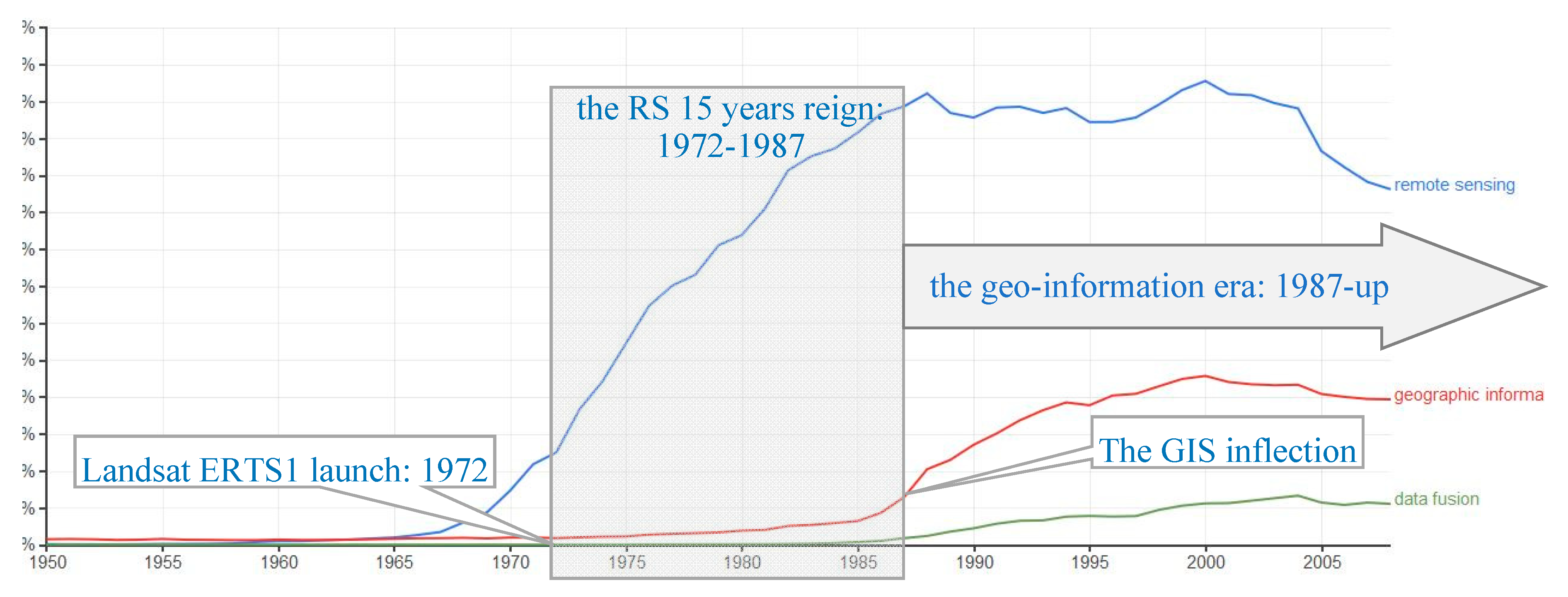
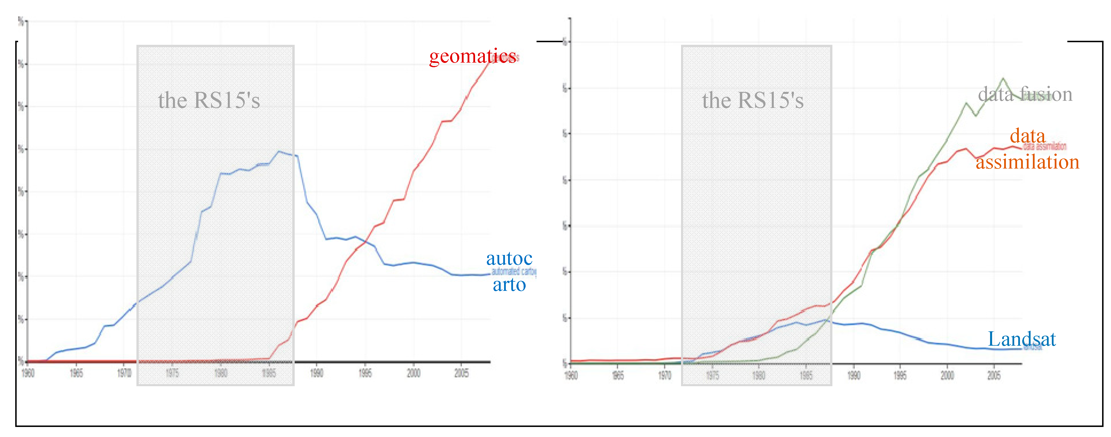
:1. Background. Where Do We Come from?
- the larger the availability of GIS, easier software, the more affordable digital cartography became, which led to the creation of academic geomatics laboratories in several countries, and the creation of the Association of Geographic Information Laboratories for Europe (AGILE) in 1998.
- more and more RS data: SPOT-1 launched in 1986, synthetic aperture radar ERS-1 launched in 1991, as well as more new sensors, new wavelengths or new radar polarizations. These new devices required a full new range of processing methods, algorithms, format conversion procedures, forms of registration, structured recording, etc., The international research community was initiating large-scale experiments to specifically explore the fusion of multi-source geo-information. This was the time of several Hydrologic and Atmospheric Pilot Experiments HAPEX [7], and the Alpilles-ReSeDA (Remote Sensing Data Assimilation) European project [8].
2. Main Objectives: What’s at Stake?
2.1. Land Cover Assessment
- Urban and infrastructure expansion, between 1990 and 2012, which has affected land with productive soil and fragments the existing landscape structure.
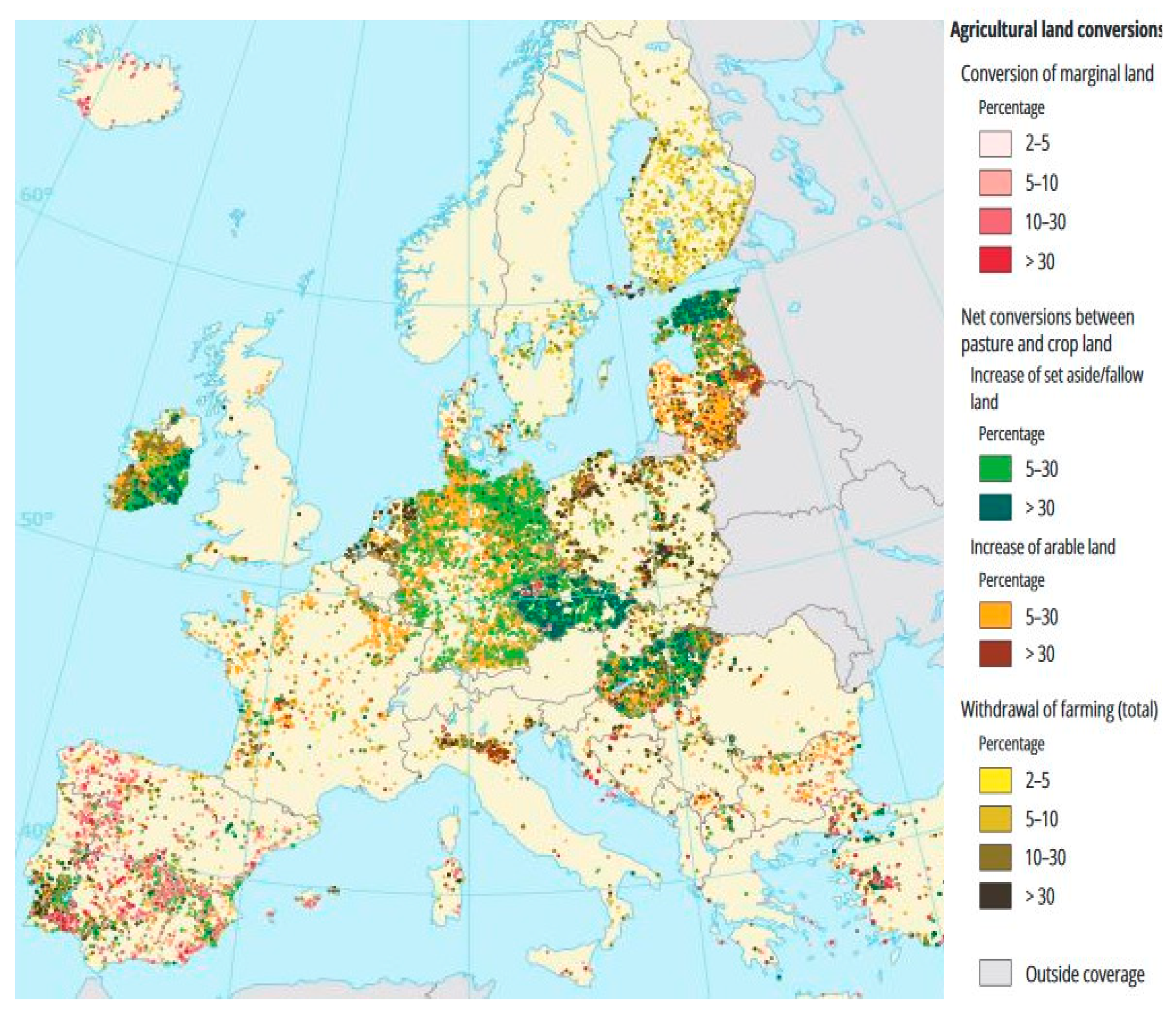
- The EU’s agricultural land, often in favorable locations, has been decreasing at an average rate of 1000 km2 per year: Associated biodiversity and traditional landscapes are affected by land take, agricultural intensification and farmland abandonment, cf. Figure 3.
- The forest area remains stable, while indicating an intensification of forestland use. This may lead to a declining quality of forest ecosystems.
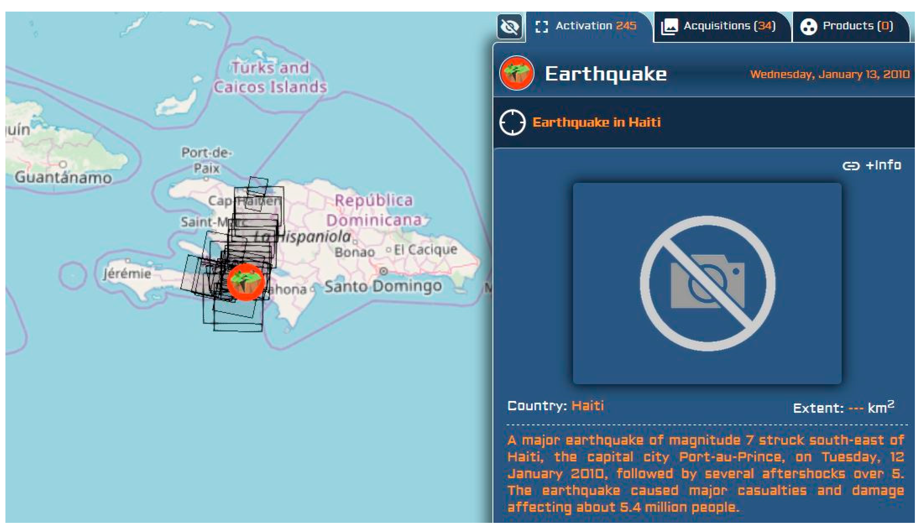
2.2. Disaster Response Management
3. Progress status: What’s Up? and What’s New?
3.1. Reviews and Literature Surveys on Specific Data Fusion Subtopics
- An IJGI special issue on “GEOBIA in a Changing World” (14 papers in 2018) [16], investigating how GEographic Object Based Image Analysis can complement pixel-based analysis. Basically, GEOBIA works with both original pixels and an overlaid areal or choropleth map, i.e., a vector representation automatically computed by a segmentation algorithm. This approach is particularly praised in land-cover studies, which are, by nature, object-based (crop fields, built-up areas, etc.), for instance: mapping rooftop vegetation [17].
- A Remote Sensing special issue on “Multi-Sensor and Multi-Data Integration in Remote Sensing” (21 papers in 2017) [18];
- A 2018 literature survey on Spatiotemporal Fusion of Multisource RS data [19];
- A 2019 review about Spatiotemporal Image Fusion in Remote Sensing [20];
- About Disaster Response Management, and Risk Assessment, an IJGI review article [23];
- About volunteered geo-info and crowdsourcing: a study on data quality assurance [24];
- And many, many … more!
3.2. What Does This Special Issue Bring to the Reader?
- Random Forest Regression [29]: applied individually to a RGB multispectral image and to a SAR image pre-processed by gray-level co-occurrence matrix descriptors (e.g., energy, homogeneity, angular second moment), to train independent classes by K-means, then training samples are selected and used in the learning process, determining the RF for each class, then applying the resulting RF to the entire image. This results in the fusion of thesurface roughness characteristics of the SAR image and the spectral characteristics of the MS image;
- Two-Branch Convolutional Neural Network [30]: CNN layers are applied to the respective input features: a principal component analysis (PCA) is performed on an hyper-spectral 144-bands image (branch 1—image provided at the IEEE-GRSS 2013 data fusion contest), then, in next layers, a series of filters whose parameters are tuned by supervised learning. The LiDAR image is processed in a similar manner (branch 2). A residual block is utilized in each branch to extract multi-scale features. Then, a fusion module is used to integrate HSI and LiDAR features, based on “squeeze-and-excitation networks” (adaptive adjust of the weighs).
- Multi-Source Time Series [31]: processing Landsat-7 ETM and Huanjing-1, over 13 years, with K-means classification, then analyzing the resulting time series with a combination of Mann-Kendall trend detection method and Theil-Sen slope analysis, to monitor the evolution of the NDVI on forest land.
- Similarity scores for Road-matching [32]: Hausdorff distance (between vertices), orientation (octant), sinuosity, mean perpendicular distance, mean length of the edges of a triangulated irregular network (TIN), and degree of connectivity (valence of intersections), are six indices used to compute a similarity score. The sources are the Istanbul Metropolitan authority, OSM, TomTom and Basarsoft (both of the latter are private navigation data).
- Point-to-Grid Distances for Point Clouds [33]: an improvement of the Iterative Closest Point (ICP) algorithm, including point-to-DEM pixel estimation, thus allowing the fusion of a point cloud (LiDAR flight campaign Apr.2017) with the digital elevation model computed from the LiDAR flight campaign Dec.2012 with a lower sampling interval (0.5 versus 0.1m.).
- 3D Reconstruction [34]: prismatic 3D building models are built by adding height values to a 2D footprint (source: OSM). The heights are computed with two different approaches, depending on the availability of sources providing a sufficient high-resolution spatial coverage at an urban scale. Sources are: (1) a pair of independent elevation models (CartoSat-1 and TanDEM-X), whose fusion results into a more accurate reference DEM;(2) a pair of a SAR and an optical image (TerraSAR-X and WorldView-2), processed by stereo grammetry fusion yielding to a DEM. High-resolution airborne LiDAR point cloud data are available only at some sub-areas, and serve as an accuracy assessment.
4. New Needs, New Challenges, New Issues
4.1. Geo-Information Confronted to the Big Data Paradigm
- new RS satellites: the European Sentinel-2 [36], and Earth Observation satellites from many new countries in the last decade, e.g., Dubai, Indonesia, Nigeria, and Venezuela, to cite a few;
- new sensors, passive or active, that are bringing more repetitive coverage, are more spatially accurate, and have a wider spectral range;
- and the forthcoming spreading of IoT sensors, whose fusion with other geo-information data sources starts being studied recently [41]. In the marine domain, Fish Aggregating Devices (FAD’s), possibly remotely monitored, are a rare source of “ground” information for oceans [42], whose development is growing very fast (though under almost no control).
- the CEOS “virtual constellations”: an inter-Agency collaboration to coordinating space-based, and ground-based data delivery systems to meet a common set of requirements within specific domains: Atmospheric Composition, Land Surface Imaging, Precipitations, and Ocean (sea surface topography and temperature, color, wind). Regarding Land Surface Imaging, the “Analysis Ready Data for Land” are satellite data processed to a minimum set of requirements, and organized into an interoperable form that allows immediate analysis with a minimum of additional user effort [43];
- the “data cube” solution: an online analytical processing (OLAP) software, to piling up data layers, over a 2D geographic grid, making cubes with many dimensions [44].
4.2. Geo-Information to the Industry, and Back
“The challenge of detecting and tracking multiple objects of interest, using multiple disparate sensors, can generally be broken down into the following steps:
- -
- -
- -
5. Conclusions
Funding
Acknowledgments
Conflicts of Interest
Abbreviations
| CEOS | Committee on Earth Observations Satellites (inter-governmental body) |
| DEM | Digital Elevation Model |
| GIS | Geographic Information System |
| GSM | Global System for Mobiles |
| HAPEX | Hydrologic and Atmospheric Pilot Experiments |
| OSM | OpenStreetMap (open cartographic data, open wiki platform) |
| HOT | Humanitarian OpenStreetMap Team (US academic based) |
| IoT | Internet of Things |
| NDVI | Normalized Difference Vegetation Index |
| RS | Remote Sensing |
| RS-15’s | the 15 glorious years of Remote Sensing (1972–87) |
| SAR | Synthetic Aperture Radar |
| UAV | Unmanned Aerial Vehicle |
| VGI | Volunteered Geographic Information |
References
- Williams, R.S., Jr.; Carter, W.D. ERTS-1, A New Window on Our Planet. In USGS Professional Paper 929; Government Printing Office: Washington, DC, USA, 1976; 384p. [Google Scholar]
- Sixth International Symposium on Automated Cartography, Ottawa, ON, Canada, 16–21 October 1983. Two Volumes. Volume 1. Available online: https://cartogis.org/docs/proceedings/archive/auto-carto-6/index.html (accessed on 17 July 2019).
- ISPRS. XVth ISPRS Congress. Technical Commission III: Mathematical Analysis of Data; ISPRS Archives: Rio de Janeiro, Brazil, 1984; Volume XXV. [Google Scholar]
- Besenicar, J.; Kengen, B. Projection of Topographic Data into Remote Sensing Images. In Proceedings of the XVIth Congress of the ISPRS, Kyoto, Japan, 17–24 July 1988; pp. 73–79. Available online: https://www.isprs.org/proceedings/XXVII/congress/part3/73_XXVII-part3.pdf (accessed on 17 July 2019).
- Jeansoulin, R. Review of Forty Years of Technological Changes in Geomatics toward the Big Data Paradigm. ISPRS Int. J. Geo Inf. 2016, 5, 155. [Google Scholar] [CrossRef]
- Edwards, G.; Jeansoulin, R. Data fusion—From a logic perspective with a view to implementation. Int. J. Geogr. Inf. Sci. 2004, 18, 303–307. [Google Scholar] [CrossRef]
- André, J.C.; Goutorbe, J.P.; Perrier, A. A Hydrologic Atmospheric Experiment the Study of Water Budget and Evaporation Flux at the Climatic Scale. Bull. Am. Meteorol. Soc. 1986, 6, 138–144. [Google Scholar]
- Prévot, L.; Baret, F.; Chanzy, A.; Olioso, A.; Wigneron, J.P.; Autret, H.; Baudin, F.; Bessemoulin, P.; Béthenod, O.; Blamont, D.; et al. Assimilation of multisensor and multitemporal remote sensing data to monitor vegetation and soil: The Alpilles-ReSeDA project. In Proceedings of the IGARSS’98. Sensing and Managing the Environment. 1998 IEEE International Geoscience and Remote Sensing. Symposium Proceedings, Seattle, WA, USA, 6–10 July 1998; Volume 5, pp. 2399–2401. [Google Scholar]
- Guo, H. Big Earth data: A new frontier in Earth and information sciences. Big Earth Data 2017, 1, 4–20. [Google Scholar] [CrossRef] [Green Version]
- European Environment Agency. CORINE Land Cover. Report. 1995. Available online: https://www.eea.europa.eu/publications/COR0-landcover (accessed on 17 July 2019).
- European Environment Agency Landscapes in Transition. An Account of 25 Years of Land Cover Change in Europe, Report No. 10/2017, 88p. Available online: https://www.eea.europa.eu/publications/landscapes-in-transition (accessed on 17 July 2019).
- Rosina, K.; Batista e Silva, F.; Vizcaino, P.; Herrera, M.M.; Freire, S.; Schiavina, M. Increasing the detail of European land use/cover data by combining heterogeneous data sets. Int. J. Digit. Earth 2018. [Google Scholar] [CrossRef]
- Langanke, T. GIO Land (GMES/Copernicus initial operations land) High Resolution Layers (HRLs): Summary of Product Specifications. European Environment Agency Copernicus Report. June 2013. Available online: https://land.copernicus.eu/user-corner/technical-library/gio-land-high-resolution-layers-hrls-2013-summary-of-product-specifications (accessed on 17 July 2019).
- Goodchild, M.F.; Glennon, J.A. Crowdsourcing geographic information for disaster response: A research frontier. Int. J. Digit. Earth 2010, 3, 231–241. [Google Scholar] [CrossRef]
- Anderson-Tarver, C. Crisis Mapping the 2010 Earthquake in OpenStreetMap Haiti. Ph.D. Thesis; University of Colorado at Boulder, 12 March 2015. Available online: https://scholar.colorado.edu/cgi/viewcontent.cgi?article=1081&context=geog_gradetds (accessed on 17 July 2019).
- ISPRS IJGI Special Issue on “GEOBIA in a Changing World” 2018. Available online: https://www.mdpi.com/journal/ijgi/special_issues/GEOBIA (accessed on 17 July 2019).
- Griffith, D.C.; Hay, G.J. Integrating GEOBIA, Machine Learning, and Volunteered Geographic Information to Map Vegetation over Rooftops. ISPRS Int. J. Geo Inf. 2018, 7, 462. [Google Scholar] [CrossRef]
- Remote Sensing Special Issue on “Multi-Sensor and Multi-Data Integration in Remote Sensing” 2017. Available online: https://www.mdpi.com/journal/remotesensing/special_issues/multi-sensor (accessed on 17 July 2019).
- Zhu, X.; Cai, F.; Tian, J.; Williams, T.K.A. Spatiotemporal Fusion of Multisource Remote Sensing Data: Literature Survey, Taxonomy, Principles, Applications, and Future Directions. Remote Sens. 2018, 10, 527. [Google Scholar] [CrossRef]
- Belgiu, M.; Stein, A. Spatiotemporal Image Fusion in Remote Sensing. Remote Sens. 2019, 11, 818. [Google Scholar] [CrossRef]
- ISPRS IJGI Special Issue “Advances and Innovations in Land Use/Cover Mapping”. 2016. Available online: https://www.mdpi.com/journal/ijgi/special_issues/land_mapping (accessed on 17 July 2019).
- Remote Sensing, Special Issue on “Multisource RS Data Fusion and Applications in Vegetation Monitoring”. 2018. Available online: https://www.mdpi.com/journal/remotesensing/special_issues/mult_data_RS (accessed on 17 July 2019).
- Miyazaki, H.; Nagai, M.; Shibasaki, R. Reviews of Geospatial Information Technology and Collaborative Data Delivery for Disaster Risk Management. ISPRS Int. J. Geo-Inf. 2015, 4, 1936–1964. [Google Scholar] [CrossRef]
- Leibovici, D.G.; Rosser, J.F.; Hodges, C.; Evans, B.; Jackson, M.J.; Higgins, C.I. On Data Quality Assurance and Conflation Entanglement in Crowdsourcing for Environmental Studies. ISPRS Int. J. Geo-Inf. 2017, 6, 78. [Google Scholar] [CrossRef]
- Wang, Y.; Kang, J.; Zhu, X.X. Fusing Spaceborne SAR Interferometry and Street View Images for 4D Urban Modeling. In Proceedings of the 21st International Conference on Information Fusion, Cambridge, UK, 10–13 July 2018; pp. 1601–1606. [Google Scholar]
- Xu, F.; Yu, H.; Wang, J.; Yang, W. Accurate Registration of Multitemporal UAV Images Based on Detection of Major Changes. In Proceedings of the 21st International Conference on Information Fusion, Cambridge, UK, 10–13 July 2018; pp. 1480–1485. [Google Scholar]
- van Der Heijden, R.W.; Kopp, H.; Kargl, F. Multi-Source Fusion Operations in Subjective Logic. In Proceedings of the 21st International Conference on Information Fusion, Cambridge, UK, 10–13 July 2018; pp. 1990–1997. [Google Scholar]
- Hammami, I.; Dezert, J.; Mercier, G. Kohonen-Based Credal Fusion of Optical and Radar Images for Land Cover Classification. In Proceedings of the 21st International Conference on Information Fusion, Cambridge, UK, 10–13 July 2018; pp. 1635–1642. [Google Scholar]
- Seo, D.K.; Kim, Y.H.; Eo, Y.D.; Lee, M.H.; Park, W.Y. Fusion of SAR and Multispectral Images Using Random Forest Regression for Change Detection. ISPRS Int. J. Geo Inf. 2018, 7, 401. [Google Scholar] [CrossRef]
- Feng, Q.; Zhu, D.; Yang, J.; Li, B. Multisource Hyperspectral and LiDAR Data Fusion for Urban Land-Use Mapping based on a Modified Two-Branch Convolutional Neural Network. ISPRS Int. J. Geo Inf. 2019, 8, 28. [Google Scholar] [CrossRef]
- Bai, B.; Tan, Y.; Guo, D.; Xu, B. Dynamic Monitoring of Forest Land in Fuling District Based on Multi-Source Time Series Remote Sensing Images. ISPRS Int. J. Geo Inf. 2019, 8, 36. [Google Scholar] [CrossRef]
- Hacar, M.; Gökgöz, T. A New, Score-Based Multi-Stage Matching Approach for Road Network Conflation in Different Road Patterns. ISPRS Int. J. Geo. Inf. 2019, 8, 81. [Google Scholar] [CrossRef]
- Boerner, R.; Xu, Y.; Baran, R.; Steinbacher, F.; Hoegner, L.; Stilla, U. Registration of Multi-Sensor Bathymetric Point Clouds in Rural Areas Using Point-to-Grid Distances. ISPRS Int. J. Geo Inf. 2019, 8, 178. [Google Scholar] [CrossRef]
- Bagheri, H.; Schmitt, M.; Zhu, X. Fusion of Multi-Sensor-Derived Heights and OSM-Derived Building Footprints for Urban 3D Reconstruction. ISPRS Int. J. Geo Inf. 2019, 8, 193. [Google Scholar] [CrossRef]
- Yao, X.C.; Li, G.Q. Big spatial vector data management: a review. Big Earth Data 2018, 2, 108–129. [Google Scholar] [CrossRef]
- Defourny, P.; Bontemps, S.; Bellemans, N.; Cara, C.; Dedieu, G.; Guzzonato, E.; Hagolle, O.; Inglada, J.; Nicola, L.; Rabaute, T.; et al. Near real-time agriculture monitoring at national scale at parcel resolution: Performance assessment of the Sen2-Agri automated system in various cropping systems around the world. RemoteSens. Environ. 2019, 221, 551–568. [Google Scholar]
- Yao, H.; Qin, R.; Chen, X. Unmanned Aerial Vehicle for Remote Sensing Applications—A Review. Remote Sens. 2019, 11, 1443. [Google Scholar] [CrossRef]
- Hoffmann, E.J.; Wang, Y.Y.; Werner, M.; Kang, J.; Zhu, X.X. Model Fusion for Building Type Classification from Aerial and Street View Images. Remote Sens. 2019, 11, 1259. [Google Scholar] [CrossRef]
- Li, J.; Zhang, Y.; Wang, X.; Qin, Q.; Wei, Z.Z.; Li, J.Z. Application of GPS Trajectory Data for Investigating the Interaction between Human Activity and Landscape Pattern. ISPRS Int. J. Geo Inf. 2016, 5, 104. [Google Scholar] [CrossRef]
- Tu, W.; Hu, Z.; Li, L.; Cao, J.; Jiang, J.; Li, Q.; Li, Q. Portraying Urban Functional Zones by Coupling Remote Sensing Imagery and Human Sensing Data. Remote. Sens. 2018, 10, 141. [Google Scholar] [CrossRef]
- The Internet of Things (IoT) in Remote Sensing: Opportunities and Challenges. Remote Sensing Special Issue. 2019. Available online: https://www.mdpi.com/journal/remotesensing/special_issues/iot_rs (accessed on 17 July 2019).
- Imzilen, T.; Lett, C.; Chassot, E.; Barde, J. Modeling trajectories of Fish Aggregating Devices with satellite images. In Proceedings of the 12th Working Party on Data Collection and Statistics (WPDCS12); p. 29. Available online: http://horizon.documentation.ird.fr/exl-doc/pleins_textes/divers17-01/010069095.pdf (accessed on 17 July 2019).
- Wulder, M.A.; Hilker, T.; White, J.C.; Coops, N.C.; Masek, J.G.; Pflugmacher, D.; Crevier, Y. Virtual constellations for global terrestrial monitoring. Remote Sens. Environ. 2015, 170, 62–76. [Google Scholar] [CrossRef] [Green Version]
- Nativi, S.; Mazzetti, P.; Craglia, M. A view-based model of data-cube to support big earth data systems interoperability. Big Earth Data 2017, 1, 75–99. [Google Scholar] [CrossRef] [Green Version]
- Clarke, D. Minimum information loss fusion in distributed sensor networks. In Proceedings of the 19th International Conference on Information Fusion, Heidelberg, Germany, 5–8 July 2016. [Google Scholar]
- Carroll, L. Sylvie and Bruno Concluded; Macmillan and Co.: London, UK; New York, NY, USA, 1983; Available online: https://archive.org/details/sylviebrunoconcl00carriala/page/n10 (accessed on 17 July 2019).


© 2019 by the author. Licensee MDPI, Basel, Switzerland. This article is an open access article distributed under the terms and conditions of the Creative Commons Attribution (CC BY) license (http://creativecommons.org/licenses/by/4.0/).
Share and Cite
Jeansoulin, R. Multi-Source Geo-Information Fusion in Transition: A Summer 2019 Snapshot. ISPRS Int. J. Geo-Inf. 2019, 8, 330. https://doi.org/10.3390/ijgi8080330
Jeansoulin R. Multi-Source Geo-Information Fusion in Transition: A Summer 2019 Snapshot. ISPRS International Journal of Geo-Information. 2019; 8(8):330. https://doi.org/10.3390/ijgi8080330
Chicago/Turabian StyleJeansoulin, Robert. 2019. "Multi-Source Geo-Information Fusion in Transition: A Summer 2019 Snapshot" ISPRS International Journal of Geo-Information 8, no. 8: 330. https://doi.org/10.3390/ijgi8080330