Article

Spatial Learning with Orientation Maps: The Influence of Different Environmental Features on Spatial Knowledge Acquisition

Institute for Geoinformatics, University of Münster, 48149 Münster, Germany
*
Author to whom correspondence should be addressed.
ISPRS Int. J. Geo-Inf. 2019, 8(3), 149; https://doi.org/10.3390/ijgi8030149
Submission received: 21 February 2019 / Revised: 14 March 2019 / Accepted: 15 March 2019 / Published: 20 March 2019

Abstract

:
The prevalent use of GPS-based navigation systems impairs peoples’ ability to orient themselves. This paper investigates whether wayfinding maps that accentuate different types of environmental features support peoples’ spatial learning. A virtual-reality driving simulator was used to investigate spatial knowledge acquisition in assisted wayfinding tasks. Two main conditions of wayfinding maps were tested against a base condition: (i) highlighting local features, i.e., landmarks, along the route and at decision points; and (ii) highlighting structural features that provide global orientation. The results show that accentuating local features supports peoples’ acquisition of route knowledge, whereas accentuating global features supports peoples’ acquisition of survey knowledge. The results contribute to the general understanding of spatial knowledge acquisition in assisted wayfinding tasks. Future navigation systems could enhance spatial knowledge by providing visual navigation support incorporating not only landmarks but structural features in wayfinding maps.

1. Introduction

Wayfinding support systems are widely used by people to get turn-by-turn instructions in assisted wayfinding situations, especially when traveling in unfamiliar environments. What used to be an elaborate task of active information search, spatial updating, and decision-making, has become a passive path-following task of executing a sequential set of turn instructions [1]. Users’ focus on environmental aspects, which is relevant for active wayfinding and navigation, is replaced by a focus on turn-by-turn instructions provided by the devices. This has negative consequences on spatial learning and orientation [2,3,4,5], hence users might be unable to make informed decisions in case of unforeseen events such as malfunction of the devices. Following blindly their wayfinding support systems with little attention to the environment has brought people into hazardous situations and led to numerous accidents. Navigation systems have been developed for research and for commercial purposes that incorporate landmarks; it has been proven that landmarks are useful environmental cues that have a positive influence both on navigation and acquisition of route knowledge [6,7,8].
In the present study we investigate whether wayfinding maps that accentuate different types of environmental features support incidental acquisition of route knowledge and survey knowledge. We accentuate two different types of environmental features: (i) local features along the route and at decision points; and (ii) global features, i.e., global landmarks, network structures, and structural regions. Empirical data is gathered in a driving simulator task followed by sketch map drawing and direction estimation tasks. We hypothesize that visually accentuating features in wayfinding maps improves the learning of these particular features, thus accentuating local features supports learning of sequential information along the route (route knowledge) and accentuating global features supports learning of the configuration of the environment (survey knowledge). Our work contributes to existing studies investigating spatial knowledge acquisition by (i) modifying visual modes of navigation assistance and examining their effect on acquisition of survey knowledge; and (ii) testing empirically the modified navigation assistance in a realistic scenario of traveling by car through the usage of a driving simulator.
The remainder of this article is structured as follows: In Section 2 we review related work on spatial knowledge acquisition and the effect of landmarks and orientation information in wayfinding instructions. We specifically identify gaps in empirical evidence investigating spatial knowledge acquisition in realistic car navigation scenarios. In Section 3 we describe the methods for creating the orientation maps, the experimental setup to test peoples’ spatial knowledge acquisition during assisted wayfinding and our hypotheses. Results are presented in Section 4 and discussed in Section 5 in the light of scientific contribution, limitations, and future work. We conclude our work in Section 6.

2. Related Works

2.1. Spatial Knowledge Acquisition during Assisted Wayfinding

Spatial knowledge is commonly categorized as landmarks knowledge, route knowledge, and survey knowledge [9]. However, it was criticized that the process of acquiring spatial knowledge is not sequential as proposed by Siegel and White [9], but a qualitative accumulation and refinement of spatial knowledge [10,11]. In a longitudinal study Ishikawa and Montello [11] investigated the microgenesis of individuals’ spatial knowledge and discussed large individual differences in this process. Individuals either acquired accurate knowledge after first exposure or did not acquire accurate knowledge, but there was little improvement on recurrent exposures. It is, therefore, reasonable to investigate peoples’ spatial knowledge acquisition within assisted wayfinding tasks with a single exposure to the route.
It was shown that the use of mobile navigation systems has negative consequences on spatial knowledge acquisition. Münzer et al. [12] compared computer-assisted navigation to traditional map-based navigation assistance and reported differences in incidental knowledge acquisition. While users of map-based navigation assistance showed good route knowledge and survey knowledge, users of computer-assisted navigation showed good route knowledge but poor survey knowledge. It was argued that the active encoding and consolidation of spatial information in working memory leads to better incidental knowledge acquisition of the map users [12,13]. Ishikawa et al. [4] compared wayfinding behavior and spatial learning of participants that either received route information from GPS devices, from paper maps, or from direct experience. Besides reporting differences in wayfinding performance, the authors showed that users of GPS devices acquired less survey knowledge compared to users who learned the route from direct exposure. Also, empirical evidence was found for a more efficient spatial learning with traditional paper maps compared to digital navigation system Dickmann [14].
Besides different modes of wayfinding assistance, the effects of different map visualizations on spatial learning have been investigated. Small screen devices require the restriction of the displayed information content, which results in a trade-off between overview and detailed information [2,15]. Maps at small scales visualizing the configuration of an environment support the acquisition of configural knowledge at the cost of wayfinding performance, whereas large scale maps accentuating route information support wayfinding performance at the cost of configural knowledge acquisition [2]. Most of the above presented works are based on rather short routes covering small areas. Empirical data were gathered testing pedestrians in assisted wayfinding tasks in the real world. Sensorimotor and cognitive processes involved in pedestrian wayfinding, however, might not be identical when driving a car, thus there is a need to investigate spatial knowledge acquisition in realistic car-driving scenarios.
Spatial learning from a map was compared to spatial learning from direct experience and from traversing a virtual environment, suggesting that the cognitive processes necessary for maintaining orientation are similar in real world and virtual environments [16]. In realistic scenario, Gramann et al. [8] investigated the effect of modified verbal navigation instructions on incidental spatial learning. Mimicking in-car navigation assistance, they gathered empirical data from participants following a route with a driving simulator in a virtual environment. Verbally accentuating landmarks at decision points significantly improved incidental spatial learning of the route [8]; however, survey knowledge acquisition was not examined. We aim to fill the gap of insight into the effects of modified visual navigation assistance on spatial knowledge acquisition, especially the acquisition of survey knowledge. Moreover, we set up a realistic scenario investigating spatial knowledge acquisition during car navigation.

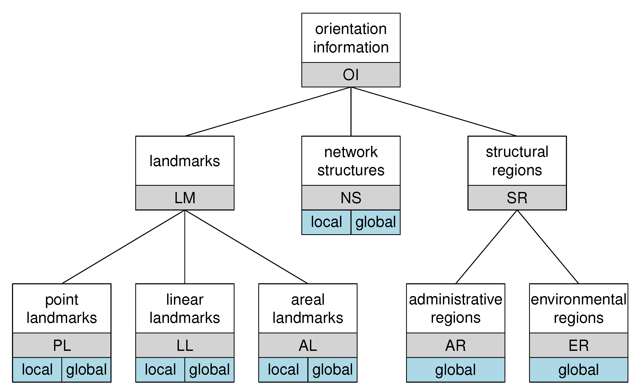
2.2. Landmarks and Orientation Information in Wayfinding Instructions

It has been widely investigated and agreed upon that landmarks are key features of spatial cognition, structuring human mental representations of space [17]. Moreover, they are important features in navigation and wayfinding [6,7]. It was shown that people include landmarks in route instructions, both at decision points and along the route [18,19,20,21,22]. Moreover, it was shown that besides local landmarks, global landmarks, i.e., off-route landmarks with sufficiently large reference region, are important features in human wayfinding instructions [23,24,25,26]. In contrast to contemporary turn-by-turn-based wayfinding support systems, human wayfinding instructions contain a significant amount of orientation information that support the acquisition of configurational knowledge [23]. Orientation information is considered to be any information, including local and global landmarks, that supports people to derive their position in space and orient themselves regarding known environmental information [27].
Several methods have been developed to identify and to automatically include landmarks in wayfinding instructions; however, to date it is unclear what strategy of landmark selection is the most beneficial for users’ spatial knowledge acquisition. Based on the characterization of Sorrows and Hirtle [28], several approaches have been proposed to select the most salient landmarks for both environmental layouts as well as route instructions (e.g., [29,30,31,32]). However, no empirical evidence in the context of spatial knowledge acquisition has been presented. Furthermore, it has been criticized that current approaches focus on point-like landmarks, neglecting regional landmarks or structural regions [1,33].

2.3. Wayfinding Assistance

Wayfinding is the process of determining and following a route between an origin and a destination [34]. A taxonomy of different human wayfinding tasks based on the knowledge structures and cognitive processes involved was developed [1,35]. Schwering et al. [1] highlight the oriented path-following task where the navigator has knowledge about the destination, the route, and the surrounding environment. While navigation system made wayfinding a task of passive path-following, i.e., survey knowledge is not available and acquisition of survey knowledge is not even supported, modified navigation instructions should support survey knowledge acquisition facilitating navigators to orient themselves on recurrent travels in the environment.
Richter and Klippel [36] presented an approach to adapt route instructions to the characteristics of the route and the environment aiming to ease the conceptualization and mental processing of route instructions. Schmid et al. [37] developed an algorithm to generate route aware maps, which combines detailed route information with overview information of the surrounding environment and bridges the gap regarding the trade-off between overview and detailed information that was identified by Münzer et al. [2]. As in the work on cognitively motivated routing algorithms that propose to reduce complexity and mental workload (e.g., [38,39,40]), ways of spatial knowledge acquisition, which we consider as crucial, is not evaluated in this research. With our work we target the empirical investigation of incidental spatial learning with modified route instructions. In particular, we visually accentuate local features and global features in wayfinding maps and evaluate the effect on the travelers’ spatial knowledge acquisition.

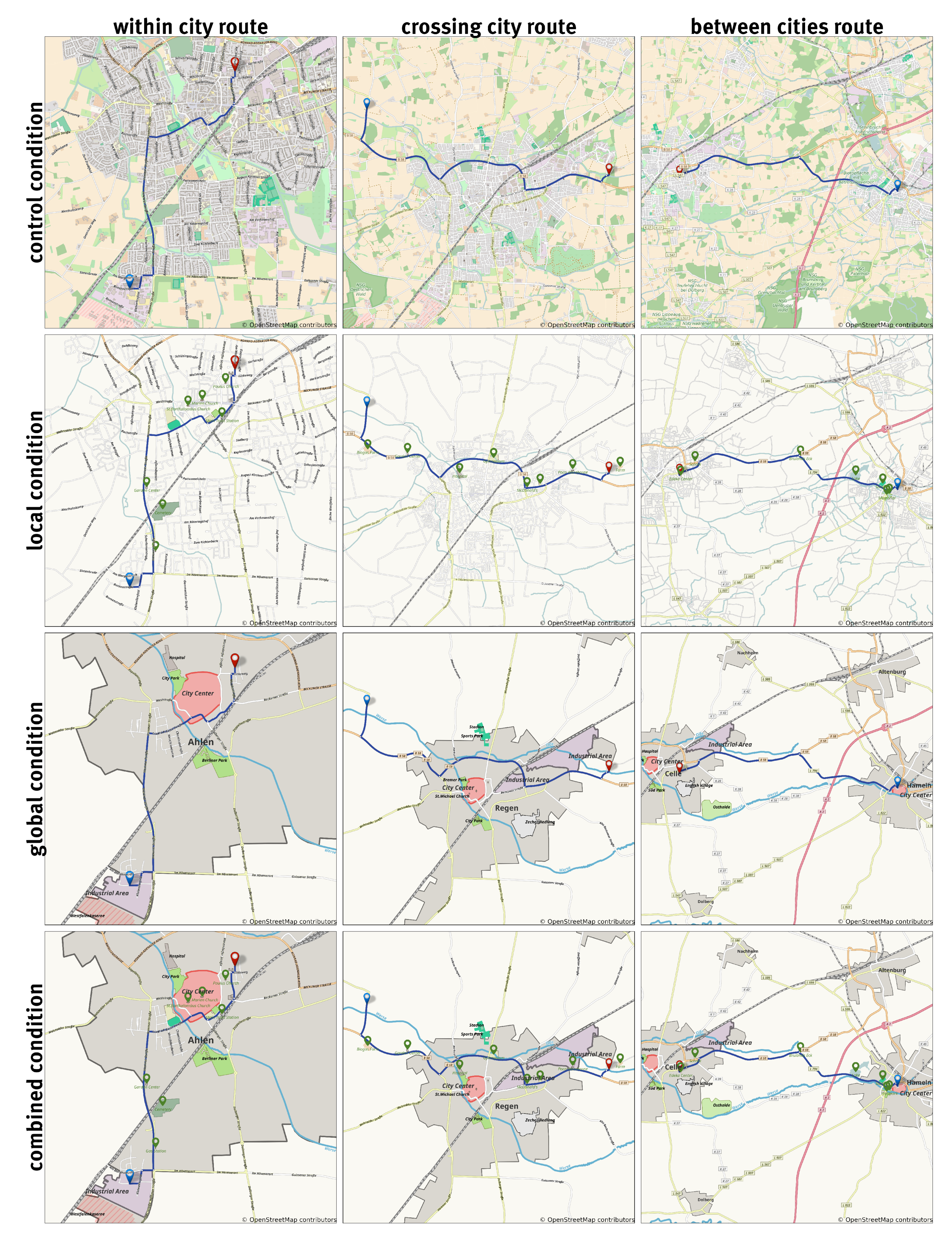
3. Materials and Methods

3.1. Participants

Participants were recruited via a mailing list of the general students’ committee; thus, most participants were students from different faculties. A total of 66 participants (m = 30, f = 36) between 18 and 37 years and with a mean age of 24.7 years (SD = 4.7) participated in the experiment. Two participants were excluded from the evaluation due to difficulties handling the driving simulator. Sketch maps of seven more participants were not considered for the data evaluation as they did not fulfill minimum requirements. Although instructed to sketch a map for a friend enabling the friend to follow the same route, sketch maps of these participants did not contain more than a single curved line. Nevertheless, the direction estimations of these participants were incorporated in the data analysis. Participants received a EUR 10 compensation for their participation.

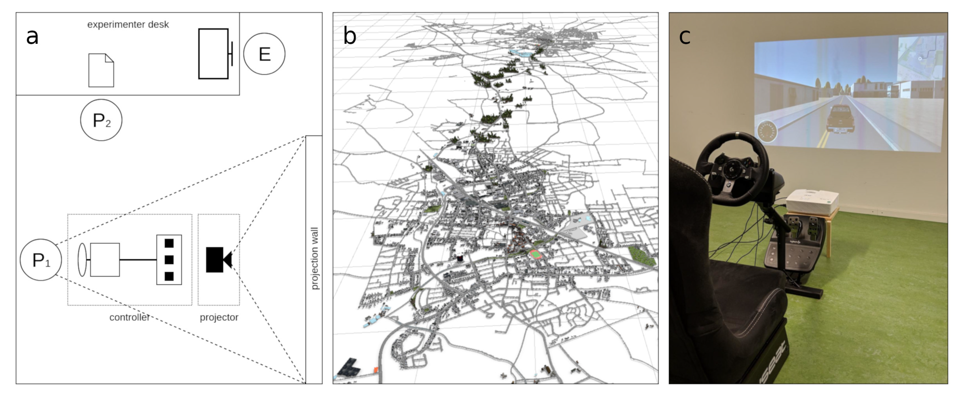
3.2. Materials and Apparatus

We modeled a virtual environment based on OpenStreetMap (https://www.openstreetmap.org) data of a real environment using CityEngine (https://www.esri.de/produkte/cityengine). The virtual model is mainly based on the network data and building footprints and generic with few variations in visual appearance. Landmarks were modeled with SketchUp (https://www.sketchup.com) and manually added to the virtual environment. As study area we chose two cities in western Germany of approximately 50K residents and a reasonable distance to be traveled within an experiment (see Figure 1 and Figure 2b). The cities lie within an approximate distance of 10 km and the environment covers the area of the two cities and the rural area in between (approx. 100 km 2 ). Participants were required to be unfamiliar with the chosen environment, thus the study area was chosen to be distinct from the city participants were recruited at and feature labels in the maps were changed. Moreover, the environment is modeled with a generic appearance, which is distinct from real world appearance. Participants were not required to be qualified drivers. Three conceptually different routes were chosen that traversed different parts of the environment. The first route (Figure 1 left) represents a drive entirely within a city, which is assumed to be a typical everyday task. It has a length of 4.36 km. The second route (Figure 1 middle) represents a drive crossing a city where start and destination are both outside of the city. This route represents typical parts of longer trips not via highways, but on primary and secondary roads, which connect or cross cities, towns, or villages. It has a length of 9.21 km. The third route (Figure 1 right) represents a drive connecting two cities, which is analogously assumed to be a typical trip for people commuting. It has a length of 10.43 km.
The driving simulation was implemented using the Unity (https://unity3d.com) game engine and set up with a force feedback steering wheel (Logitech G920 (https://www.logitechg.com/products/driving/driving-force-racing-wheel.html)), as can be seen in Figure 2c. The driving simulation incorporated the virtual model and was used for the assisted wayfinding tasks as well as the pointing tasks. The study setup mimicked the setup presented by Gramann et al. [8], where participants were seated in the driving simulator in front of a projection wall. Additionally, there was the experimenter desk, used to control the driving simulator and for the pen and paper tasks participants performed after driving.
We modified wayfinding maps based on the classification scheme of orientation information (Figure 3) we developed and presented before [33]. The classification scheme specifies feature types and features roles in route maps and distinguishes the feature types landmarks, network structures and structural regions. Moreover, it specifies the role features might take regarding the route, i.e., local or global. Landmarks are defined as “geographic objects that structure human mental representations of space” ([17], p. 7) and can be any point-like, linear, or areal object in the environment. Landmarks may be relevant in local or global context of a route. Network structures are defined as the relevant street network to be selected for orientation support. This might be on the one hand the network skeleton constituting the overall structure of the street network (global context), and on the other hand the route relevant network including side streets and detailed network related to the route (local context). Structural regions comprise administrative regions and environmental regions, which are relevant for the global context of the route. Whereas areal landmarks are separate geographic objects with an areal extend, structural regions in contrast are defined by their bona fide (environmental regions) or fiat boundaries (administrative regions) [41,42], which might have containment relations with other features. Environmental regions have a semantic meaning, which refers to some kind of homogeneous and perceivable environmental structure, such as urban vs. rural areas or a city center [33]. In this work we aim to evaluate the classified features regarding their potential for improving incidental spatial learning, considering the local or global role features might take for supporting orientation.

3.3. Experimental Design

We manipulated the map conditions and the route types. There were four map condition and three routes resulting in a 4x3-experimental design (see Figure 1). The four conditions are based on a factorial design of two factors, i.e., accentuating local features and accentuating global features. The control condition of a standard wayfinding map (no local features and no global features accentuated) was compared to a local condition (only local features accentuated), a global condition (only global features accentuated), and a combined condition (local features and global features accentuated). The control condition consists of all map information (here: all information of a standard map from OpenStreetMap), whereas the modified maps conditions disregard information related to land cover and accentuate local and/or global features as specified in Section 3.2.

3.4. Procedure

Participants were randomly assigned to a condition, with a balanced number of participants per condition (between-subject design). All participants drove all three routes in a counterbalanced order (within-subject design).
Participants were introduced to the driving simulator and started with a free driving and familiarization phase lasting 5 min. For this phase, an exemplary environment distinct from the test environment was used. Participants could ask any questions and no measures were taken. In the test phase, participants were instructed to drive with the driving simulator the three different routes displayed on the navigation device. They saw an overview map before and after each wayfinding task and a dynamic map marking their current location during the wayfinding task. The overview map contained the whole route to be traveled and mimicked the appearance of typical in-car navigation systems, which usually provides an overview of the route before the drive. The dynamic map contained a small map extract at a fixed maps scale visualizing the current location and route to be traveled. Both maps were north-aligned and not rotating with respect to the viewing direction. After each route, participants drew a sketch map and performed a series of pointing task. The order of routes was counterbalanced. After the test phase, participants filled questionnaires assessing (i) general questions such as gender and age; (ii) individual differences in environmental spatial cognition; and (iii) perceived mental workload.
Individual differences were assessed with the Questionnaire on Spatial Strategies [43]. It comprises the three scales global self-confidence, related to egocentric strategies (FRS_EGO), survey strategy (FRS_SURVEY) and knowledge of cardinal directions (FRS_CARDI). The latter scale was disregarded as it is not relevant for virtual environment studies.
We used the NASA-TLX questionnaire to assess the subjectively perceived workload of the participants during the experiment. This was done to test for an effect of the map conditions on the users’ workload during the experiment. The first part of the questionnaire (pair-wise comparison of factors), which provides a weighing for the six scales, has been criticized for poor reliability and differentiation, with recommendations to disregard it [44]. We therefore used the unweighted NASA-TLX questionnaire (second part only), which measures the subjective perceived workload based on the ratings of six scales [45].

3.5. Dependent Measures

Spatial knowledge acquisition was assessed by the sketch map drawing and the direction estimation tasks. Sketch maps were on the one hand analyzed with the classification scheme described by Krukar et al. [46], distinguishing route-like and survey-like sketch map types. The classification scheme was developed based on human route descriptions and assesses the extend of route knowledge and survey knowledge information in sketch maps by proposing six criteria for each dimension. These criteria were shown to load on the two separate concepts of route-likeness and survey-likeness [46]. The classification, however, neglects the accuracy and correctness of information contained in the sketch maps. Therefore, on the other hand, a descriptive analysis of sketch maps was performed, quantifying the number of local features and global features participants correctly reproduced from the accentuated features in the different conditions. Three raters (one of the authors and two student assistants) rated the sketch maps. An active communication between the raters, as suggested by Krukar et al. [46], assured the shared understanding of the rating criteria accounting for the common problem of subjective sketch map ratings.
Route knowledge was assessed via the route-likeness scale and the descriptive analysis of correctly recalled landmarks, which were accentuated in the wayfinding maps and visible in the environment. We expected that conditions that accentuate landmarks in the wayfinding maps would increase their recognition and thus lead to a higher number of correctly recalled landmarks in the sketch map drawing tasks. In terms of the route-likeness measure, it was expected that conditions that accentuate landmarks would raise the route-likeness scale. The pointing task assesses the knowledge of directions between important places in the environment perceived from an egocentric perspective. Because route knowledge only requires the sequential association of the landmarks with the route, we did not expect any significant improvements in pointing performance in conditions accentuating local features. Although participants might infer relative directions based on sequential route information, we would not expect effect sizes that are comparable to the effects when the landmarks have been learned from a survey map. Route knowledge is related to individuals’ position and orientation and anchored in the egocentric reference frame [2,47], thus it was expected that individual differences, especially differences with respect to the FRS_EGO scale, influence the pointing accuracy, and the assessment of route knowledge.
Survey knowledge was assessed with the direction estimation, the survey-likeness measure, and the analysis of correctly recalled global features from the sketch maps, which served as indicators for the acquisition of knowledge about the configuration of the environment. In map assisted wayfinding tasks, individuals relate allocentric route directions to the egocentric travel perspective by mentally transforming them into the egocentric reference frame. We therefore expected that wayfinding maps that accentuate global features of the environment would improve peoples’ knowledge of egocentric directions assessed with the pointing task. Survey-likeness measure and results of the descriptive analysis with respect to global features are analogously expected to be influenced by accentuation global features in the wayfinding maps. The survey strategy is related to survey knowledge [43], thus we expected an effect of the FRS_SURVEY scale on the survey knowledge measures.
Despite the fact that many typical drives are recurrent and in familiar environments, we investigate the effect of different wayfinding maps on peoples’ incidental spatial knowledge acquisition in unfamiliar environments. We assumed that the conditions that we developed would not differ in the dependent measures for all three route types, and thus be representative for all types of travels in unfamiliar environments.
Regarding the mental workload, which was measured with the NASA-TLX questionnaire, we did not expect any effect of the map conditions on the subjectively perceived workload. Lastly, wayfinding performance of the driving tasks was measured with the number of wrong turns and task completion time. However, we did not expect any differences in wayfinding performance with respect to the different map conditions.

4. Results

We used R [48] and lme4 [49] to perform linear mixed-effects analyses to test the effects of independent variable on the dependent variables. Table 1 presents basic descriptive statistics, whereas Table 2 summarizes the results of the linear mixed-effects analyses as described in the following.

4.1. Direction Estimation

We analyzed the effect of map conditions and route type on the pointing deviation. As fixed effects, we entered the factors for the map conditions, i.e., accentuating local features (ACCENT_LOCAL) and accentuation global features (ACCENT_GLOBAL), the route type (ROUTE) and the individual differences (FRS_EGO and FRS_SURVEY) into the model. As random effects, we had intercepts for subjects. Visual inspection of residual plots did not reveal any obvious deviations from homoscedasticity or normality. p-values were obtained by likelihood ratio tests of the full model with the effect in question against the model without the effect in question.
Accentuating local features did not affect pointing deviation ( X 2 (1) = 0.01, p = 0.90, −0.53 ± 4.22 SE). Accentuating global features affected pointing deviation ( X 2 (1) = 3.77, p = 0.05), lowering it by about 8.46 ± 4.30 SE (95% CI: −16.87–0.04). There was no effect of interaction between accentuating local features and accentuating global features ( X 2 (1) = 1.05, p = 0.31). There was no effect of the different route types on the pointing deviation ( X 2 (2) = 0.33, p = 0.85), showing a negative coefficient for the crossing city route (−0.91 ± 3.36 SE) and a positive coefficient for the between cities route (1.02 ± 3.39 SE). The results, moreover, show an effect of FRS_EGO on pointing deviation ( X 2 (1) = 5.06, p = 0.02), lowering it by about 5.05 ± 2.20 SE, i.e., increasing FRS_EGO by value 1 decreases the pointing deviation by about 5.05 .

4.2. Recall of Landmarks and Structures

We analyzed the percentage of local features and the percentage of global features participants correctly recalled from the accentuated features in the different conditions. We performed separate linear mixed-effects analyses of the relationship between (i) the percentage of recalled local features and map conditions, and (ii) the percentage of recalled global features and map conditions. Moreover, we analyzed the effect of the route types on the percentage of correctly recalled local features and global features. As fixed effects, we entered the factors for the map conditions, the route type, and the individual differences into the model. As random effects, we had intercepts for subjects. Visual inspection of residual plots did not reveal any obvious deviations from homoscedasticity or normality. p-values were obtained by likelihood ratio tests of the full model with the effect in question against the model without the effect in question.

4.2.1. Landmarks

Accentuating local features affected the percentage of local features reproduced in sketch maps ( X 2 (1) = 27.23, p = 1.81 × 10 7 ), raising it by about 22.28% ± 3.81% SE. Accentuating global features did not affect the percentage of local features reproduced in sketch maps ( X 2 (1) = 0.12, p = 0.73, −1.33% ± 3.79% SE). There was no effect of interaction between accentuating local features and accentuating global features ( X 2 (1) = 0.78, p = 0.38). There was no effect of the different route types on the percentage of local features reproduced in sketch maps ( X 2 (2) = 3.43, p = 0.18), showing a positive coefficient for the crossing city route (5.14% ± 3.75% SE) and a negative coefficient for the between cities route (−1.55% ± 3.74% SE). The results, moreover, show an effect of FRS_EGO on the percentage of local features reproduced in sketch maps ( X 2 (1) = 4.24, p = 0.04), raising it by about 4.04% ± 1.93% SE.

4.2.2. Structures

Accentuating local features did not affect the percentage of global features reproduced in sketch maps ( X 2 (1) = 1.28, p = 0.26, −2.60% ± 2.29% SE). Accentuating global features affected the percentage of global features reproduced in sketch maps ( X 2 (1) = 11.57, p = 6.69 × 10 4 ), raising it by about 8.16% ± 2.28% SE. There was no effect of interaction between accentuating local features and accentuating global features ( X 2 (1) = 0.51, p = 0.48). There was no effect of the different route types on the percentage of global features reproduced in sketch maps ( X 2 (2) = 3.84, p = 0.15), showing negative coefficients for the crossing city route (−2.50% ± 1.27% SE) and the between cities route (−0.98% ± 1.26% SE).

4.3. Sketch Map Types

We applied the classification scheme developed by Krukar et al. [46] to investigate the sketch maps in terms of route-likeness and survey-likeness. We performed separate linear mixed-effects analyses of the relationship between (i) the route-likeness measure and map conditions, and (ii) the survey-likeness measure and map conditions. Moreover, we analyzed the effect of the route type on the route-likeness and survey-likeness measures. As fixed effects, we entered the factors for the map conditions, the route type, and the individual differences into the model. As random effects, we had intercepts for subjects. Visual inspection of residual plots did not reveal any obvious deviations from homoscedasticity or normality. p-values were obtained by likelihood ratio tests of the full model with the effect in question against the model without the effect in question.

4.3.1. Route-Likeness

Accentuating local features affected the route-likeness measure of the sketch maps ( X 2 (1) = 5.87, p = 0.02), raising it by about 0.40 ± 0.16 SE. Accentuating global features did not affect the route-likeness measure of the sketch maps ( X 2 (1) = 0.67, p = 0.41, 0.13 ± 0.16 SE). There was no effect of interaction between accentuating local features and accentuating global features ( X 2 (1) = 0.50, p = 0.48). There was no effect of the different route types on the route-likeness measure of the sketch maps ( X 2 (2) = 3.16, p = 0.21), showing a negative coefficient for the crossing city route (−0.02 ± 0.12 SE) and a positive coefficient for the between cities route (0.18 ± 0.12 SE). The results, moreover, show an effect of FRS_EGO on the route-likeness measure of the sketch maps ( X 2 (1) = 8.98, p = 2.74 × 10 3 ), raising it by about 0.25 ± 0.08 SE.

4.3.2. Survey-Likeness

Accentuating local features did not affect the survey-likeness of the sketch maps ( X 2 (1) = 0.33, p = 0.56, −0.16 ± 0.28 SE). Accentuating global features affected the survey-likeness of the sketch maps ( X 2 (1) = 5.81, p = 0.02), raising it by about 0.69 ± 0.28 SE. There was no effect of interaction between accentuating local features and accentuating global features ( X 2 (1) = 3.77 × 10 5 , p = 0.99). There was no effect of the different route types on the survey-likeness measure of the sketch maps ( X 2 (2) = 2.35, p = 0.31), showing a positive coefficient for the crossing city route (0.08 ± 0.17 SE) and a negative coefficient for the between cities route (−0.17 ± 0.17 SE).

4.4. Mental Workload and Wayfinding Performance

We constructed a linear model to test for an effect of the map conditions on the perceived workload. This model was not significant (F(3,60) = 0.20, p = 0.90).
Wayfinding performance was measured by quantifying wrong turns of the participants during the wayfinding task. The maximum number of wrong turns for all participants and route was two. Linear mixed-effects models analyzing the effect of map conditions on the number of wrong turns did not show any effect (accentuating local features X 2 (1) = 0.14, p = 0.71, 0.03 ± 0.08 SE; accentuating global features X 2 (1) = 0.01, p = 0.91, 0.01 ± 0.08 SE; interaction X 2 (1) = 0.41, p = 0.52).

5. Discussion

In this study, we investigated the effects of accentuating different types of features in wayfinding maps on users’ incidental spatial learning. The conditions consisted of (i) a control condition in which no local and no global features were accentuated, (ii) local condition in which local features were accentuated, (iii) a global conditions in which global features were accentuated, and (iv) a combined condition in which both local and global features were accentuated. All conditions were tested for three conceptually different types of routes. The different route types were (i) within a city, (ii) crossing a city, and (iii) between two cities. We showed that accentuating local features improves peoples’ route knowledge, whereas accentuating global features improves peoples’ survey knowledge. There was no effect of the different route types on participants incidental spatial learning.

5.1. Spatial Knowledge Acquisition

We provide empirical evidence that accentuating local features in wayfinding maps supports the acquisition of route knowledge, which confirms our hypothesis. This is in line with previous research about the effect of accentuating local features in verbal and visual modes [6,7,8]. Both the analysis of correctly recalled local features and the assessment of the route-likeness measure increased in the local and combined condition, which indicates that accentuating local features in wayfinding instructions improves peoples’ route knowledge. Our data does not provide evidence for an effect of accentuating local features on survey knowledge acquisition, indicating that accentuating local features in assisted wayfinding instructions makes people more aware of the local context of the route; however, it does not suffice to acquire survey knowledge of the environment. Obviously, participants who report a higher global self-confidence related to egocentric strategies perform better in tasks assessing route knowledge, thus incorporating these measures in the statistical models removes between participant variation related to individual differences.
The survey knowledge acquisition was measured with the pointing task, descriptive analysis of correctly recalled global features, and survey-likeness measure. We could show that accentuating global features in wayfinding maps had effects on all three dependent measures, confirming our hypotheses: Participants in the global condition and combined condition performed significantly better in the direction estimation task and drew more survey-like sketch maps including significantly more correct global features.
Contrary to our expectations, individual differences related to the survey strategy did not affect survey knowledge acquisition. This might have several reasons. The spatial strategies FRS_EGO and FRS_SURVEY were shown to correlate substantially [43], which is evident in our data (r = 0.62, p = 3.88 × 10 8 ). We included both FRS_EGO and FRS_SURVEY as fixed effects, modeling dependent measures with correlated variables. Thus, part of the variance explained by the FRS_EGO scale might also relate to the FRS_SURVEY scale. No significant effect of the survey strategy, moreover, only indicates that we could not reject the null hypothesis of differences in the dependent measures that are due to individual differences with respect to the survey strategy, thus our results apply to individuals regardless of differences in their survey strategy. Participants reporting a high survey strategy and participants reporting low survey strategy equivalently benefit when global features are accentuated in wayfinding maps.
None of the models showed a significant interaction of accentuating local features and accentuating global features, indicating that the factors separately effected the acquisition of route knowledge and survey knowledge. Participants who received wayfinding maps that accentuated both local features and global features, performed significantly better on dependent measures assessing route knowledge and survey knowledge, in contrast to participants receiving wayfinding maps in the control condition, where no local features or global features were accentuated. Participants who received wayfinding maps that accentuated local features only performed better in route knowledge measures; participants who received wayfinding maps that accentuated global features only performed better in survey knowledge measures.
Our findings correspond with other studies about the effect of navigation instructions on peoples’ spatial knowledge related to pedestrian navigation [4,12,13,14]. In contrast to previous finding, we demonstrated that survey knowledge acquisition is not conflicting with wayfinding performance (see [2,15]), hence wayfinding performance was very good in our experiment and there were no significant effects of map conditions on the wayfinding performance measures.

5.2. Route types and Mental Workload

As there were no significant differences in the results with respect to the three conceptually different route types, we argue that our findings generally apply to car navigation in unfamiliar environments. This provides the opportunity for commercial navigation systems to support spatial knowledge acquisition with a single solution only. There are current trends in commercial navigation system providers to refer to landmarks, especially at decision points. We would recommend to not only include local landmarks, which trigger learning of the route, but to incorporate global features in wayfinding maps to support the acquisition of survey knowledge during car navigation. In contrast to contemporary solutions, which are criticized for impairing spatial learning and orientation, solutions that support spatial knowledge acquisition would train spatial skills, and continuous use of such systems might even show beneficial long-term effect on cognitive abilities (e.g., [50]).
Based on the results from the NASA-TLX we cannot reject the null hypothesis of no effect of the map conditions on the subjectively perceived workload, suggesting that the modified wayfinding maps did not cause higher mental demand. This indicates that the modification of wayfinding maps accentuating local and global features leads to better spatial learning of route information as well as survey information without increasing the effort during the wayfinding task, which is in line with previous research [8].

5.3. Limitations and Future Work

Some aspects regarding the cartographic representation of the wayfinding maps and the visualization during the experiment shall be mentioned here: We aim for an automatic process of generating wayfinding maps that accentuate local and global features supporting spatial knowledge acquisition. Modified wayfinding maps in the current experiment were semi-automatically generated based on open data available at OpenStreetMap and Open.NRW (https://open.nrw/). With evidence presented in the manuscript, we will opt for a fully automated process to generate wayfinding maps supporting spatial knowledge acquisition.
Decisions regarding the visualization of the maps during the experiment were made in terms of fixed map scales and map alignment to limit the experimental conditions to be considered in this controlled experimental setup. Dynamic map scales and map alignments are key features of digital navigation systems. Other research has investigated the effect of different map alignments on navigation performance [2]; however, to our knowledge, there is no research on investigating optimal map scales with respect to spatial learning during assisted wayfinding tasks. This shall be investigated in future work.
Our work is based on the selection of features that were accentuated in the wayfinding maps, wherein the cartographic representation was a necessary step in the methodology. While we agree that different cartographic representations would affect the perception and mental processing of environmental features, the focus of our work was on spatial learning and mental spatial representations induced by different types of environmental features. Moreover, based on the experimental setup, conclusions with respect to long-term memory effects might not be permissible at this stage. Participants of the experiment had a relatively low age range (mean = 24.7, sd = 4.7) and a wider age range might be more representative. Most participants will have reached maturity when GPS-based navigation systems were widely used already, whereas an older age group of participants may have experience with paper maps. Furthermore, the general concern of being under experiment and the potential psychological influence with respect to participants attention shall be mentioned here, which might have introduced additional noise in the data. Participants instructions for the recall tasks therefore specifically referred to natural situations of giving a route instruction to a friend who is unfamiliar with the environment.

6. Conclusions

The increasing use of GPS-based navigation systems turned the former effortful task of active information search, spatial updating, and decision-making into a passive path-following task. As outlined above, this has negative consequences on spatial learning and orientation. In this paper, we hypothesized that maps for assisted car navigation can be modified in a way that supports spatial knowledge acquisition and leads to better orientation of the users. We prepared wayfinding maps that accentuate local features and global features, respectively, and compared them to the control condition of a standard wayfinding map. We investigated the effect on peoples’ spatial knowledge acquisition during assisted wayfinding and showed that accentuating local features and global features leads to better spatial learning supporting route knowledge and survey knowledge, respectively. Based on our finding, we argue that the best maps to support spatial knowledge acquisition accentuate both local features and global features. Future navigation devices should therefore not only incorporate local features in wayfinding maps, such as landmarks at decision points or along the route, but also global features to support users in the acquisition and maintenance of an oriented mental representation of space. In future work we on the one hand aim to investigate optimal map scales with respect to spatial learning support, and on the other hand fully automate the process to generate orientation maps.

Author Contributions

Conceptualization, Heinrich Löwen; methodology, Heinrich Löwen; software, Heinrich Löwen; formal analysis, Heinrich Löwen; investigation, Heinrich Löwen; writing—original draft preparation, Heinrich Löwen; writing—review and editing, Jakub Krukar and Angela Schwering; visualization, Heinrich Löwen; supervision, Jakub Krukar and Angela Schwering.

Funding

This project has received funding from the European Research Council (ERC) under the European Union’s Horizon 2020 research and innovation programme (grant agreement n 637645).

Acknowledgments

We thank Katharina Hovestadt and Cornelia Zygar for supporting the implementation and the experiment.

Conflicts of Interest

The authors declare no conflict of interest. The funders had no role in the design of the study; in the collection, analyses, or interpretation of data; in the writing of the manuscript, or in the decision to publish the results.

References

  1. Schwering, A.; Krukar, J.; Li, R.; Anacta, V.J.; Fuest, S. Wayfinding Through Orientation. Spat. Cogn. Comput. 2017, 17, 273–303. [Google Scholar] [CrossRef] [Green Version]
  2. Münzer, S.; Zimmer, H.D.; Baus, J. Navigation assistance: A trade-off between wayfinding support and configural learning support. J. Exp. Psychol. Appl. 2012, 18, 18–37. [Google Scholar] [CrossRef] [PubMed]
  3. Krüger, A.; Aslan, I.; Zimmer, H. The Effects of Mobile Pedestrian Navigation Systems on the Concurrent Acquisition of Route and Survey Knowledge. In Mobile Human-Computer Interaction-MobileHCI 2004; Brewster, S., Dunlop, M., Eds.; Springer: Berlin/Heidelberg, Germany, 2004; pp. 446–450. [Google Scholar]
  4. Ishikawa, T.; Fujiwara, H.; Imai, O.; Okabe, A. Wayfinding with a GPS-based mobile navigation system: A comparison with maps and direct experience. J. Environ. Psychol. 2008, 28, 74–82. [Google Scholar] [CrossRef]
  5. Burnett, G.E.; Lee, K. The Effect of Vehicle Navigation Systems on the Formation of Cognitive Maps. In International Conference of Traffic and Transport Psychology; Underwood, G., Ed.; Elsevier: Amsterdam, The Netherlands, 2005. [Google Scholar]
  6. Burnett, G. ‘Turn right at the Traffic Lights’: The Requirement for Landmarks in Vehicle Navigation Systems. J. Navig. 2000, 53, 499–510. [Google Scholar] [CrossRef] [Green Version]
  7. May, A.J.; Ross, T. Presence and Quality of Navigational Landmarks: Effect on Driver Performance and Implications for Design. Hum. Factors J. Hum. Factors Ergon. Soc. 2006, 48, 346–361. [Google Scholar] [CrossRef] [PubMed] [Green Version]
  8. Gramann, K.; Hoepner, P.; Karrer-Gauss, K. Modified Navigation Instructions for Spatial Navigation Assistance Systems Lead to Incidental Spatial Learning. Front. Psychol. 2017, 8. [Google Scholar] [CrossRef] [PubMed]
  9. Siegel, A.W.; White, S.H. The Development of Spatial Representations of Large-Scale Environments. In Advances in Child Development and Behavior; Reese, H., Ed.; Academic Press: New York, NY, USA, 1975; Volume 10, pp. 9–55. [Google Scholar]
  10. Montello, D.R. A new framework for understanding the acquisition of spatial knowledge in large-scale environments. In Spatial and Temporal Reasoning in Geographic Information Systems; Egenhofer, M.J., Golledge, R.G., Eds.; Oxford University Press: New York, NY, USA, 1998; pp. 143–154. [Google Scholar]
  11. Ishikawa, T.; Montello, D.R. Spatial knowledge acquisition from direct experience in the environment: Individual differences in the development of metric knowledge and the integration of separately learned places. Cogn. Psychol. 2006, 52, 93–129. [Google Scholar] [CrossRef] [PubMed]
  12. Münzer, S.; Zimmer, H.D.; Schwalm, M.; Baus, J.; Aslan, I. Computer-assisted navigation and the acquisition of route and survey knowledge. J. Environ. Psychol. 2006, 26, 300–308. [Google Scholar] [CrossRef]
  13. Ishikawa, T.; Takahashi, K. Relationships between Methods for Presenting Information on Navigation Tools and Users’ Wayfinding Behavior. Cartogr. Perspect. 2014, 17–28. [Google Scholar] [CrossRef]
  14. Dickmann, F. City Maps Versus Map-Based Navigation Systems—An Empirical Approach to Building Mental Representations. Cartogr. J. 2012, 49, 62–69. [Google Scholar] [CrossRef]
  15. Gartner, G.; Radoczky, V. Schematic vs. Topographic Maps in Pedestrian Navigation: How Much Map Detail is Necessary to Support Wayfinding. In Proceedings of the AAAI Spring Symposium: Reasoning with Mental and External Diagrams: Computational Modeling and Spatial Assistance; The AAAI Press: Menlo Park, CA, USA, 2005; pp. 41–47. [Google Scholar]
  16. Richardson, A.E.; Montello, D.R.; Hegarty, M. Spatial knowledge acquisition from maps and from navigation in real and virtual environments. Mem. Cogn. 1999, 27, 741–750. [Google Scholar] [CrossRef] [Green Version]
  17. Richter, K.F.; Winter, S. Landmarks: GIScience for Intelligent Services; Springer: Cham, Switzerland, 2014. [Google Scholar]
  18. Denis, M. The description of routes: A cognitive approach to the production of spatial discourse. Cahiers de Psychologie Cognitive 1997, 16, 409–458. [Google Scholar]
  19. Daniel, M.P.; Denis, M. Spatial Descriptions as Navigational Aids: A Cognitive Analysis of Route Directions. Kognitionswissenschaft 1998, 7, 45–52. [Google Scholar] [CrossRef]
  20. Michon, P.E.; Denis, M. When and Why Are Visual Landmarks Used in Giving Directions? In Spatial Information Theory: Foundations of Geographic Information Science International Conference, COSIT 2001 Morro Bay, CA, USA, September 19–23, 2001 Proceedings; Montello, D.R., Ed.; Springer: Berlin/Heidelberg, Germany, 2001; pp. 292–305. [Google Scholar]
  21. Winter, S.; Tomko, M.; Elias, B.; Sester, M. Landmark Hierarchies in Context. Environ. Plan. B Plan. Des. 2008, 35, 381–398. [Google Scholar] [CrossRef]
  22. Tom, A.; Denis, M. Referring to Landmark or Street Information in Route Directions: What Difference Does It Make? In Spatial Information Theory. Foundations of Geographic Information Science: International Conference, COSIT 2003; Kuhn, W., Worboys, M.F., Timpf, S., Eds.; Springer: Berlin/ Heidelberg, Germany, 2003; pp. 362–374. [Google Scholar]
  23. Anacta, V.J.A.; Schwering, A.; Li, R.; Muenzer, S. Orientation information in wayfinding instructions: Evidences from human verbal and visual instructions. GeoJournal 2017, 82, 567–583. [Google Scholar] [CrossRef]
  24. Lovelace, K.L.; Hegarty, M.; Montello, D.R. Elements of Good Route Directions in Familiar and Unfamiliar Environments. In Spatial Information Theory. Cognitive and Computational Foundations of Geographic Information Science; Freksa, C., Mark, D.M., Eds.; Springer: Berlin/Heidelberg, Germany, 1999; pp. 65–82. [Google Scholar]
  25. Steck, S.D.; Mallot, H.A. The Role of Global and Local Landmarks in Virtual Environment Navigation. Presence Teleoperators Virtual Environ. 2000, 9, 69–83. [Google Scholar] [CrossRef] [Green Version]
  26. Li, R.; Korda, A.; Radtke, M.; Schwering, A. Visualising distant off-screen landmarks on mobile devices to support spatial orientation. J. Locat. Based Serv. 2014, 8, 166–178. [Google Scholar] [CrossRef]
  27. Krukar, J.; Schwering, A. What is Orientation? In Proceedings of the 13th Biannual Conference of the German Cognitive Science Society; Barkowsky, T., Llansola, Z.F., Schultheis, H., van de Ven, J., Eds.; KogWis: Space for Cognition: Bremen, Germany, 2016; pp. 115–118. [Google Scholar]
  28. Sorrows, M.E.; Hirtle, S.C. The Nature of Landmarks for Real and Electronic Spaces. In Spatial Information Theory. Cognitive and Computational Foundations of Geographic Information Science: International Conference COSIT’99 Stade, Germany, August 25–29, 1999 Proceedings; Freksa, C., Mark, D.M., Eds.; Springer: Berlin/Heidelberg, Germany, 1999; pp. 37–50. [Google Scholar]
  29. Raubal, M.; Winter, S. Enriching Wayfinding Instructions with Local Landmarks. In Geographic Information Science: Second International Conference, GIScience 2002; Lecture Notes in Computer Science; Egenhofer, M.J., Mark, D.M., Eds.; Springer: Boulder, CO, USA, 2002; pp. 243–259. [Google Scholar]
  30. Nothegger, C.; Winter, S.; Raubal, M. Selection of Salient Features for Route Directions. Spat. Cogn. Comput. 2004, 4, 113–136. [Google Scholar] [CrossRef]
  31. Duckham, M.; Winter, S.; Robinson, M. Including landmarks in routing instructions. J. Locat. Based Serv. 2010, 4, 28–52. [Google Scholar] [CrossRef]
  32. Caduff, D.; Timpf, S. On the assessment of landmark salience for human navigation. Cogn. Process. 2008, 9, 249–267. [Google Scholar] [CrossRef]
  33. Löwen, H.; Krukar, J.; Schwering, A. How should Orientation Maps look like? In Proceedings of the 21th AGILE International Conference on Geographic Information Science, Lund, Sweden, 12–15 June 2018. [Google Scholar]
  34. Golledge, R.G. Human wayfinding and cognitive maps. In Wayfinding Behavior: Cognitive Mapping and Other Spatial Processes; Golledge, R.G., Ed.; The John Hopkins University Press: Baltimore, MD, USA, 1999; Chapter 1; pp. 5–45. [Google Scholar]
  35. Wiener, J.M.; Büchner, S.J.; Hölscher, C. Taxonomy of Human Wayfinding Tasks: A Knowledge-Based Approach. Spat. Cogn. Comput. 2009, 9, 152–165. [Google Scholar] [CrossRef] [Green Version]
  36. Richter, K.F.; Klippel, A. A Model for Context-Specific Route Directions. In Spatial Cognition IV. Reasoning, Action, Interaction: International Conference Spatial Cognition 2004, Frauenchiemsee, Germany, October 11–13, 2004, Revised Selected Papers; Freksa, C., Knauff, M., Krieg-Brückner, B., Nebel, B., Barkowsky, T., Eds.; Springer: Frauenchiemsee, Germany, 2005; Volume 3343, pp. 58–78. [Google Scholar]
  37. Schmid, F.; Richter, K.F.; Peters, D. Route Aware Maps: Multigranular Wayfinding Assistance. Spat. Cogn. Comput. 2010, 10, 184–206. [Google Scholar] [CrossRef]
  38. Duckham, M.; Kulik, L. “Simplest” Paths: Automated Route Selection for Navigation. In Spatial Information Theory. Foundations of Geographic Information Science: International Conference, COSIT 2003, Kartause Ittingen, Switzerland, September 24–28, 2003. Proceedings; Kuhn, W., Worboys, M.F., Timpf, S., Eds.; Springer: Berlin/Heidelberg, Germany, 2003; pp. 169–185. [Google Scholar]
  39. Richter, K.F. A Uniform Handling of Different Landmark Types in Route Directions. In Spatial Information Theory; Winter, S., Duckham, M., Kulik, L., Kuipers, B., Eds.; Springer: Berlin/Heidelberg, Germany, 2007; pp. 373–389. [Google Scholar]
  40. Richter, K.F.; Duckham, M. Simplest Instructions: Finding Easy-to-Describe Routes for Navigation. In Geographic Information Science; Cova, T.J., Miller, H.J., Beard, K., Frank, A.U., Goodchild, M.F., Eds.; Springer: Berlin/Heidelberg, Germany, 2008; pp. 274–289. [Google Scholar]
  41. Smith, B.; Mark, D.M. Ontology and Geographic Kinds. In Proceedings of the 8th International Symposium on Spatial Data Handling (SDH’98), Vancouver, BC, Canada, 11–15 July 1998; pp. 267–282. [Google Scholar]
  42. Galton, A. On the Ontological Status of Geographic Boundaries. In Foundations of Geographic Information Science; Taylor & Francis: Abingdon, UK, 2003; pp. 160–182. [Google Scholar]
  43. Münzer, S.; Hölscher, C. Entwicklung und Validierung eines Fragebogens zu räumlichen Strategien. Diagnostica 2011, 57, 111–125. [Google Scholar] [CrossRef]
  44. Nygren, T.E. Psychometric Properties of Subjective Workload Measurement Techniques: Implications for Their Use in the Assessment of Perceived Mental Workload. Hum. Factors J. Hum. Factors Ergon. Soc. 1991, 33, 17–33. [Google Scholar] [CrossRef]
  45. Hart, S.G.; Staveland, L.E. Development of NASA-TLX (Task Load Index): Results of Empirical and Theoretical Research. In Human Mental Workload; Advances in Psychology; Hancock, P.A., Meshkati, N., Eds.; North-Holland: Amsterdam, The Netherlands, 1988; Volume 52, pp. 139–183. [Google Scholar]
  46. Krukar, J.; Münzer, S.; Lörch, L.; Anacta, V.J.; Fuest, S.; Schwering, A. Distinguishing Sketch Map Types: A Flexible Feature-Based Classification. In Spatial Cognition XI; Creem-Regehr, S., Schöning, J., Klippel, A., Eds.; Springer International Publishing: Cham, Switzerland, 2018; pp. 279–292. [Google Scholar]
  47. Montello, D.R.; Richardson, A.E.; Hegarty, M.; Provenza, M. A Comparison of Methods for Estimating Directions in Egocentric Space. Perception 1999, 28, 981–1000. [Google Scholar] [CrossRef]
  48. R Core Team. R: A Language and Environment for Statistical Computing; R Foundation for Statistical Computing: Vienna, Austria, 2018. [Google Scholar]
  49. Bates, D.; Mächler, M.; Bolker, B.; Walker, S. Fitting Linear Mixed-Effects Models Using lme4. J. Stat. Softw. 2015, 67, 1–48. [Google Scholar] [CrossRef]
  50. Maguire, E.A.; Woollett, K.; Spiers, H.J. London taxi drivers and bus drivers: A structural MRI and neuropsychological analysis. Hippocampus 2006, 16, 1091–1101. [Google Scholar] [CrossRef] [Green Version]
Figure 1. Experiment design with wayfinding maps of 4 map conditions (rows) and 3 route types (columns).
Ijgi 08 00149 g001
Figure 2. Experiment setup; (a) Experimental setup. Participants were seated in P 1 for the driving and pointing tasks and in P 2 for pen and paper tasks; (b) Modeled environment; (c) Example of an experimental condition in the driving simulator.
Ijgi 08 00149 g002
Figure 3. Classification scheme of feature types and feature roles for orientation information in wayfinding maps.
Ijgi 08 00149 g003
Table 1. Descriptive statistics of the dependent measures with respect to the map conditions.
ConditionPointing DeviationRecall LocalRecall GlobalRoute-LikenessSurvey-Likeness
Mean (Sd)Mean% (Sd)Mean% (Sd)Mean (Sd)Mean (Sd)
(1) control55.93 (56.74)31.65 (21.14)10.11 (10.77)3.14 (0.77)1.11 (1.20)
(2) local54.26 (52.95)54.39 (25.50)5.01 (7.03)3.51 (0.87)0.80 (0.94)
(3) global47.91 (49.50)30.68 (21.20)15.56 (11.35)3.23 (0.99)1.64 (1.62)
(4) combined54.54 (52.27)47.22 (23.82)13.88 (12.53)3.39 (0.89)1.36 (1.53)
Table 2. Results of the linear mixed-effects analyses for the different relationships between fixed effects (columns) and dependent measures (rows). Fixed effects: accentuating local features, accentuating global features, route type, individual differences; dependent measures: pointing deviation, recall of local features, recall of global features, route-likeness, survey-likeness.
Fixed Effects
ACCENT_LOCALACCENT_GLOBALROUTEFRS_EGOFRS_SURVEY
Pointing X 2 (1) = 0.01, X 2 (1) = 3.77, X 2 (2) = 0.33, X 2 (1) = 5.06, X 2 (1) = 2.22,
Deviationp = 0.90p= 0.05 *p = 0.85p= 0.02 *p = 0.14
Recall X 2 (1) = 27.23, X 2 (1) = 0.12, X 2 (2) = 3.43, X 2 (1) = 4.24, X 2 (1) = 0.73,
Localp= 1.81 × 10 7 ***p = 0.73p = 0.18p= 0.04 *p = 0.39
Recall X 2 (1) = 1.28, X 2 (1) = 11.57, X 2 (2) = 3.84, X 2 (1) = 0.80, X 2 (1) = 0.57,
Globalp = 0.26p= 6.69 × 10 4 ***p = 0.15p = 0.37p = 0.45
Route- X 2 (1) = 5.87, X 2 (1) = 0.67, X 2 (2) = 3.16, X 2 (1) = 8.98, X 2 (1) = 0.22,
Likenessp= 0.02 *p = 0.41p = 0.21p= 2.74 × 10 3 **p = 0.64
Survey- X 2 (1) = 0.33, X 2 (1) = 5.81, X 2 (2) = 2.35, X 2 (2) = 1.98, X 2 (2) = 1.98,
Likenessp = 0.56p= 0.02 *p = 0.31p = 0.16p = 0.45
Bold highlights significant values for better readibility; * signs indicate significant levels, which is standard for statistics.

