Land Use/Land Cover Dynamics and Modeling of Urban Land Expansion by the Integration of Cellular Automata and Markov Chain

 ,
,  , ,
, ,
Abstract
1. Introduction
- (1)
- What was the trend of LULC change within the study area in the past (1988–2016), and which LULC classes were mostly affected by urbanization and where?
- (2)
- What growth and change patterns can be expected in the future?
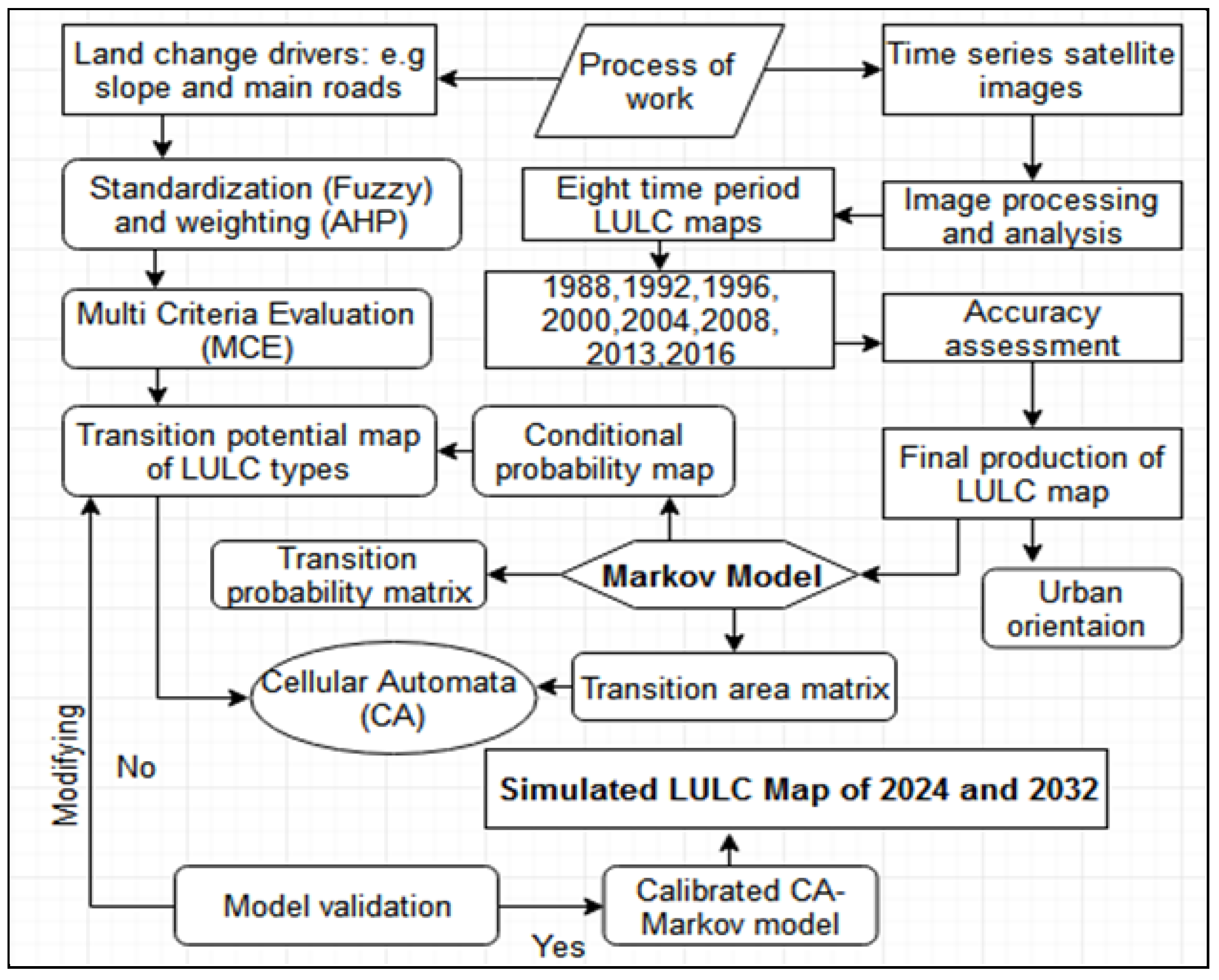
2. Methodology
2.1. Study Area
2.2. Data
2.3. Pre-Processing of Images and Design of Image Classification
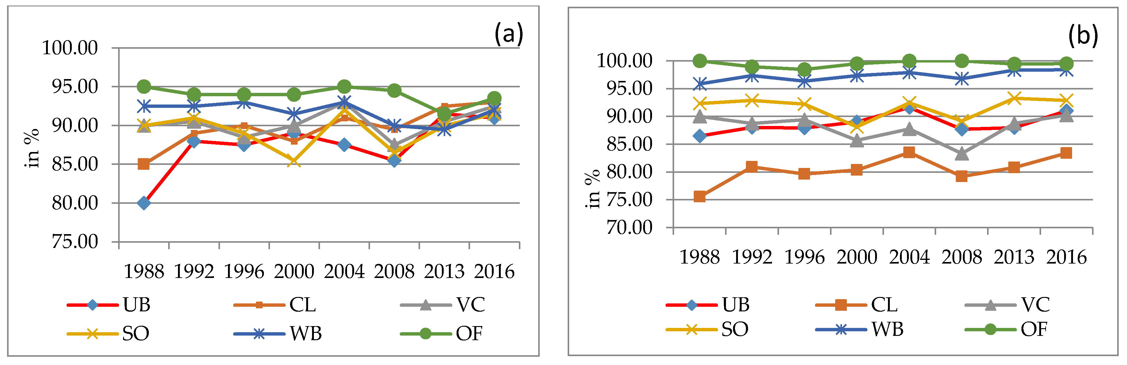
2.4. Accuracy Assessment
2.5. Measuring Urban/Built up Area Expansion Rate
2.6. Quantification of LULC Based Transition Analysis
2.7. Urban Expansion and Orientation
2.8. Simulation of LULC Change
3. Result and Discussion
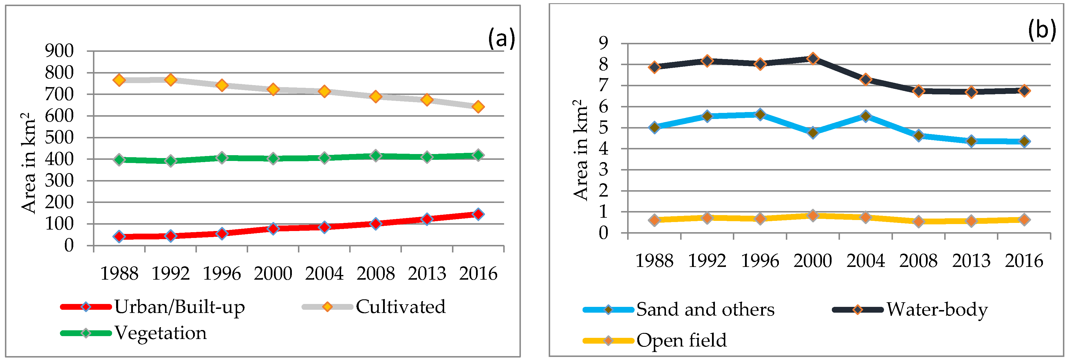
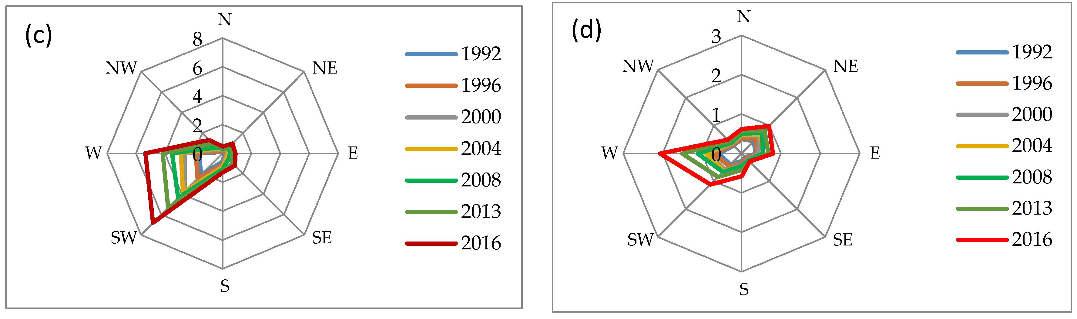
3.1. LULC Change
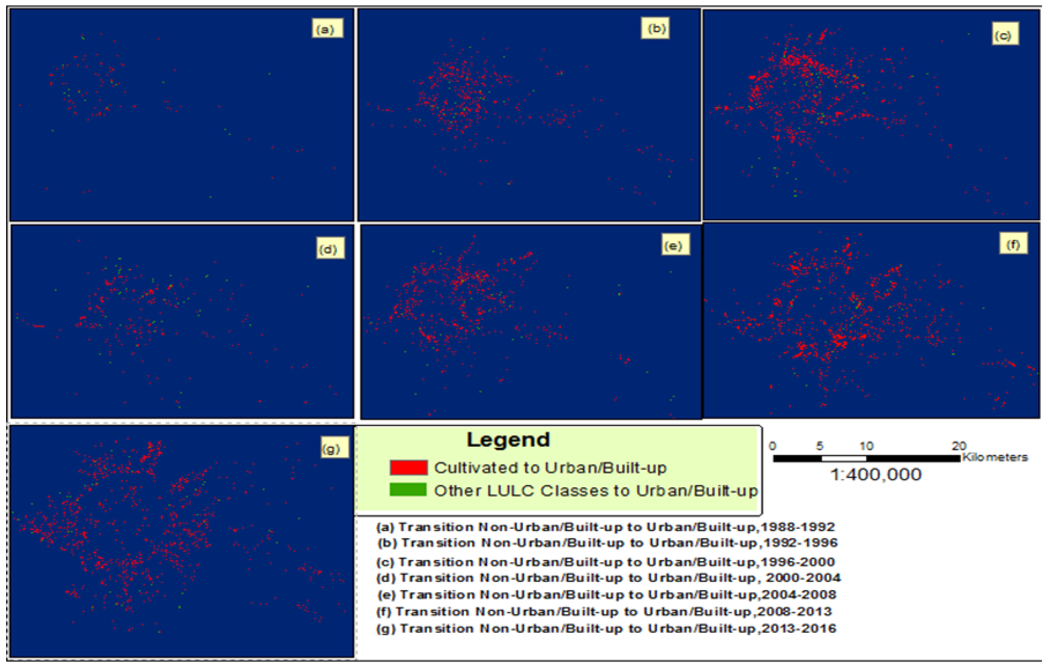
3.2. Spatiotemporal Transition of LULC
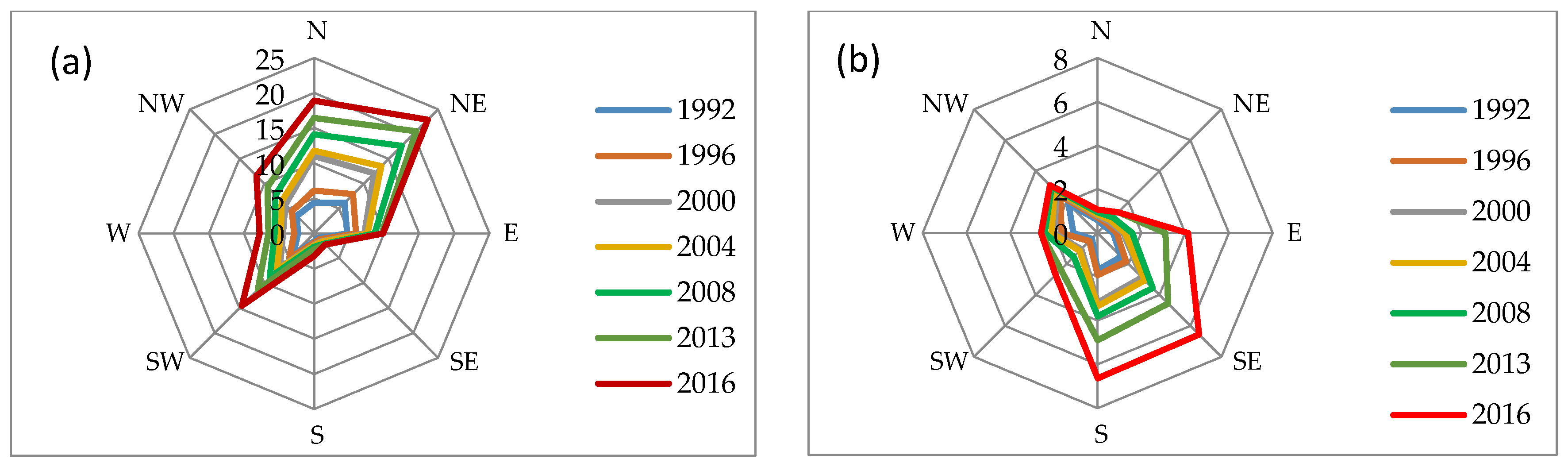
3.3. Urban Area Expansion and Orientation
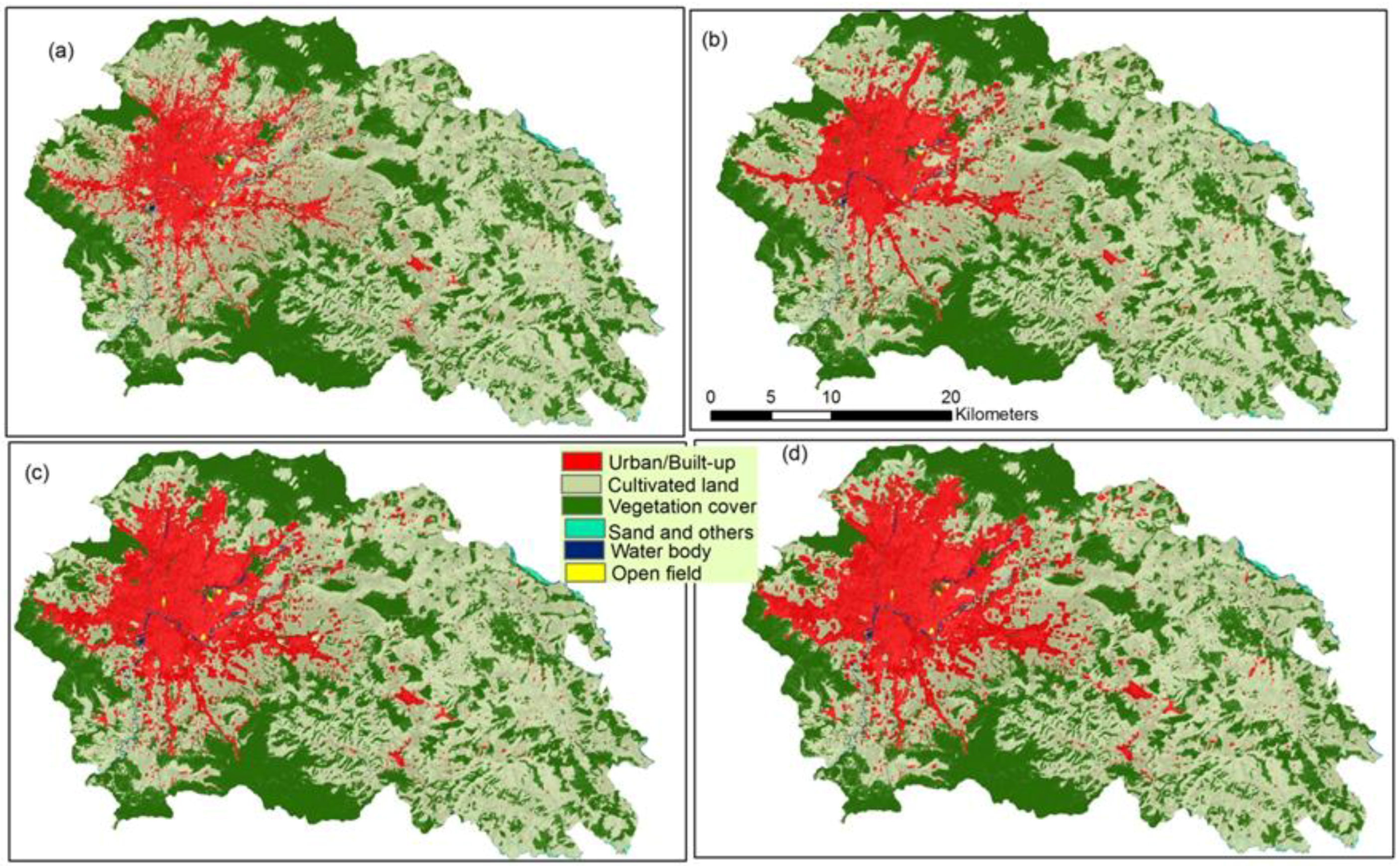
3.4. CA–Markov Model
4. Conclusions
Acknowledgments
Author Contributions
Conflicts of Interest
References
- Guan, D.; Li, H.; Inohae, T.; Su, W.; Nagaie, T.; Hokao, K. Modeling urban land use change by the integration of cellular automaton and markov model. Ecol. Model. 2011, 222, 3761–3772. [Google Scholar] [CrossRef]
- Sherbinin, A.D. A Ciesin Thematic Guide to Land Land: Use and Land Use and Land Use and Land—Cover Change (LUCC) cover Change (LUCC); Center for International Earth Science Information Network (CIESIN), Columbia University: Palisades, NY, USA, 2002. [Google Scholar]
- Eastman, J.R.; van Fossen, M.; Solo’rzano, L.A. Transition Potential Modeling for Land-Cover Change, 1st ed.; ESRI Press: Redlands, CA, USA, 2005. [Google Scholar]
- Rai, R.; Zhang, Y.; Paudel, B.; Li, S.; Khanal, N. A synthesis of studies on land use and land cover dynamics during 1930–2015 in bangladesh. Sustainability 2017, 9, 1866. [Google Scholar] [CrossRef]
- Briassoulis, H. Analysis of Land Use Change: Theoretical and Modeling Approaches; Regional Research Institute, West Virginia University: Morgantown, WV, USA, 2000. [Google Scholar]
- Bal Kumar, K.C. Internal Migration in Nepal, Population Monograph of Nepal; Central Bureau of Statistics: Kathmandu, Nepal, 2003.
- Seto, K.C.; Fragkias, M.G.B.; Reilly, M.K. A meta-analysis of global urban land expansion. PLoS ONE 2011, 6. [Google Scholar] [CrossRef] [PubMed]
- Yuan, F.; Sawaya, K.E.; Loeffelholz, B.C.; Bauer, M.E. Land cover classification and change analysis of the twin cities (minnesota) metropolitan area by multitemporal landsat remote sensing. Remote Sens. Environ. 2005, 98, 317–328. [Google Scholar] [CrossRef]
- Sun, C.; Wu, Z.-F.; Lv, Z.-Q.; Yao, N.; Wei, J.-B. Quantifying different types of urban growth and the change dynamic in guangzhou using multi-temporal remote sensing data. Int. J. Appl. Earth Obs. Geoinform. 2013, 21, 409–417. [Google Scholar] [CrossRef]
- Zhao, M.; Cheng, W.; Zhou, C.; Li, M.; Huang, K.; Wang, N. Assessing spatiotemporal characteristics of urbanization dynamics in southeast asia using time series of dmsp/ols nighttime light data. Remote Sens. 2018, 10, 47. [Google Scholar] [CrossRef]
- Lu, Q.; Chang, N.-B.; Joyce, J.; Chen, A.S.; Savic, D.A.; Djordjevic, S.; Fu, G. Exploring the potential climate change impact on urban growth in london by a cellular automata-based markov chain model. Comput. Environ. Urban Syst. 2017, 68, 121–132. [Google Scholar] [CrossRef]
- Li, X.; Yeh, A.G.-O. Modelling sustainable urban development by the integration of constrained cellular automata and GIS. Int. J. Geogr. Inform. Tion Sci. 2000, 14, 131–152. [Google Scholar] [CrossRef]
- Wu, K.-Y.; Zhang, H. Land use dynamics, built-up land expansion patterns, and driving forces analysis of the fast-growing hangzhou metropolitan area, eastern China (1978–2008). Appl. Geogr. 2012, 34, 137–145. [Google Scholar] [CrossRef]
- Dubovyk, O.; Sliuzas, R.; Flacke, J. Spatio-temporal modelling of informal settlement development in sancaktepe district, istanbul, turkey. ISPRS J. Photogramm. Remote Sens. 2011, 66, 235–246. [Google Scholar] [CrossRef]
- Poelmans, L.; Van Rompaey, A. Detecting and modelling spatial patterns of urban sprawl in highly fragmented areas: A case study in the flanders–brussels region. Landsc. Urban Plan. 2009, 93, 10–19. [Google Scholar] [CrossRef]
- Cohen, B. Urbanization in developing countries: Current trends, future projections, and key challenges for sustainability. Technol. Soc. 2006, 28, 63–80. [Google Scholar] [CrossRef]
- Shafizadeh Moghadam, H.; Helbich, M. Spatiotemporal urbanization processes in the megacity of Mumbai, India: A markov chains-cellular automata urban growth model. Appl. Geogr. 2013, 40, 140–149. [Google Scholar] [CrossRef]
- Rimal, B.; Zhang, L.; Keshtkar, H.; Sun, X.; Rijal, S. Quantifying the spatiotemporal pattern of urban expansion and hazard and risk area identification in the kaski district of nepal. Land 2018, 7, 37. [Google Scholar] [CrossRef]
- Dewan, A.M.; Yamaguchi, Y. Using remote sensing and GIS to detect and monitor land use and land cover change in dhaka metropolitan of bangladesh during 1960–2005. Environ. Monit. Assess. 2009, 150, 237–249. [Google Scholar] [CrossRef] [PubMed]
- Thapa, R.B.; Murayama, Y. Scenario based urban growth allocation in Kathmandu valley, nepal. Landsc. Urban Plan. 2012, 105, 140–148. [Google Scholar] [CrossRef]
- Jiang, B.; Yao, X. Geospatial analysis and modeling of urban structure and dynamics: An overview. In Geospatial Analysis and Modelling of Urban Structure and Dynamics; Jiang, B., Yao, X., Eds.; Springer: Dordrecht, The Netherlands, 2010; pp. 3–11. [Google Scholar]
- Jokar Arsanjani, J.; Helbich, M.; Kainz, W.; Darvishi Boloorani, A. Integration of logistic regression, markov chain and cellular automata models to simulate urban expansion. Int. J. Appl. Earth Obs. Geoinform. 2013, 21, 265–275. [Google Scholar] [CrossRef]
- Hopkins, L.D.; Kaza, N.; Pallathucheril, V.G. A Data Model to Represent Plans and Regulations in Urban Simulation Model, 1st ed.; ESRI: Redlands, CA, USA, 2005. [Google Scholar]
- Campbell, J.B. Introduction to Remote Sensing; The Guilford Press: New York, NY, USA, 1996. [Google Scholar]
- Thapa, R.B.; Murayama, Y. Examining spatiotemporal urbanization patterns in Kathmandu valley, nepal: Remote sensing and spatial metrics approaches. Remote Sens. 2009, 1, 534–556. [Google Scholar] [CrossRef]
- Cheng, J.; Masser, I. Urban growth pattern modeling: A case study of wuhan city, pr China. Landsc. Urban Plan. 2003, 62, 199–217. [Google Scholar] [CrossRef]
- Mas, J.-F.; Kolb, M.; Paegelow, M.; Camacho Olmedo, M.T.; Houet, T. Inductive pattern-based land use/cover change models: A comparison of four software packages. Environ. Model. Softw. 2014, 51, 94–111. [Google Scholar] [CrossRef]
- Wu, D.; Liu, J.; Wang, S.; Wang, R. Simulating urban expansion by coupling a stochastic cellular automata model and socioeconomic indicators. Stoch. Environ. Res. Risk Assess. 2010, 24, 235–245. [Google Scholar] [CrossRef]
- Allen, J.; Lu, K. Modeling and prediction of future urban growth in the charleston region of south carolina: A gis-based integrated approach. Ecol. Soc. 2003, 8. [Google Scholar] [CrossRef]
- Cheng, J. Modelling Spatial and Temporal Urban Growth; Utrecht University: Utrecht, The Netherlands, 2003. [Google Scholar]
- Batty, M.; Xie, Y. Urban Growth Using Cellular Automata Models, 1st ed.; ESRI Press: Redlands, CA, USA, 2005. [Google Scholar]
- Keshtkar, H.; Voigt, W. A spatiotemporal analysis of landscape change using an integrated markov chain and cellular automata models. Model. Earth Syst. Environ. 2015, 2. [Google Scholar] [CrossRef]
- Rimal, B.; Zhang, L.; Keshtkar, H.; Wang, N.; Lin, Y. Monitoring and modeling of spatiotemporal urban expansion and land-use/land-cover change using integrated markov chain cellular automata model. ISPRS Int. J. Geo-Inf. 2017, 6, 1–21. [Google Scholar] [CrossRef]
- Kityuttachai, K.; Tripathi, N.; Tipdecho, T.; Shrestha, R. Ca-markov analysis of constrained coastal urban growth modeling: Hua hin seaside city, thailand. Sustainability 2013, 5, 1480. [Google Scholar] [CrossRef]
- García, A.M.; Santé, I.; Boullón, M.; Crecente, R. Calibration of an urban cellular automaton model by using statistical techniques and a genetic algorithm. Application to a small urban settlement of nw spain. Int. J. Geogr. Inf. Sci. 2013, 27, 1593–1611. [Google Scholar] [CrossRef]
- Ke, X.; Qi, L.; Zeng, C. A partitioned and asynchronous cellular automata model for urban growth simulation. Int. J. Geogr. Inf. Sci. 2016, 30, 637–659. [Google Scholar] [CrossRef]
- Araya, Y.H.; Cabral, P. Analysis and modeling of urban land cover change in setúbal and sesimbra, portugal. Remote Sens. 2010, 2, 1549–1563. [Google Scholar] [CrossRef]
- Munshi, T.; Zuidgeest, M.; Brussel, M.; van Maarseveen, M. Logistic regression and cellular automata-based modelling of retail, commercial and residential development in the city of ahmedabad, India. Cities 2014, 39, 68–86. [Google Scholar] [CrossRef]
- Puertas, O.L.; Henríquez, C.; Meza, F.J. Assessing spatial dynamics of urban growth using an integrated land use model. Application in santiago metropolitan area, 2010–2045. Land Use Policy 2014, 38, 415–425. [Google Scholar] [CrossRef]
- Han, Y.; Jia, H. Simulating the spatial dynamics of urban growth with an integrated modeling approach: A case study of foshan, China. Ecol. Model. 2017, 353, 107–116. [Google Scholar] [CrossRef]
- Clarke, K.C. Land use change modeling with sleuth: Improving calibration with a genetic algorithm. In Geomatic Approaches for Modeling Land Change Scenarios; Camacho Olmedo, M.T., Paegelow, M., Mas, J.-F., Escobar, F., Eds.; Springer International Publishing: Cham, Switzerland, 2018; pp. 139–161. [Google Scholar]
- Rodrigues, H.; Soares-Filho, B. A short presentation of dinamica ego. In Geomatic Approaches for Modeling Land Change Scenarios; Camacho Olmedo, M.T., Paegelow, M., Mas, J.-F., Escobar, F., Eds.; Springer International Publishing: Cham, Switzerland, 2018; pp. 493–498. [Google Scholar]
- Verburg, P.H.; Veldkamp, A. Projecting land use transitions at forest fringes in the philippines at two spatial scales. Landsc. Ecol. 2004, 19, 77–98. [Google Scholar] [CrossRef]
- Verburg, P.H.; Crossman, N.; Ellis, E.C.; Heinimann, A.; Hostert, P.; Mertz, O.; Nagendra, H.; Sikor, T.; Erb, K.-H.; Golubiewski, N.; et al. Land system science and sustainable development of the earth system: A global land project perspective. Anthropocene 2015, 12, 29–41. [Google Scholar] [CrossRef]
- Theobald, D. Landscape patterns of exurban growth in the USA from 1980 to 2020. Ecol. Soc. 2005, 10. [Google Scholar] [CrossRef]
- Sleeter, B.M.; Wood, N.J.; Soulard, C.E.; Wilson, T.S. Projecting community changes in hazard exposure to support long-term risk reduction: A case study of tsunami hazards in the U.S. Pacific northwest. Int. J. Disaster Risk Reduct. 2017, 22, 10–22. [Google Scholar] [CrossRef]
- Muzzini, E.; Aparicio, G. Urban Growth and Spatial Transition in Nepal; The World Bank: Washington, DC, USA, 2013. [Google Scholar]
- UNDESA. World Urbanization Prospects, the 2014 Revision; United Nations, Department of Economic and Social Affairs, Population Division: New York, NY, USA, 2014. [Google Scholar]
- Central Bureau of Statistics. Population Monograph of Nepal; National Planning Commission Secretariat, CBS: Kathmandu, Nepal, 2014.
- Rimal, B.; Zhang, L.; Fu, D.; Kunwar, R.; Zhai, Y. Monitoring urban growth and the nepal earthquake 2015 for sustainability of Kathmandu valley, Nepal. Land 2017, 6, 1–23. [Google Scholar] [CrossRef]
- MoFALD. Local Level Reconstruction Report; Ministry of Federal Affairs and Local Development (MoFALD), Nepal Government: Kathmandu, Nepal, 2017.
- MoUD. National Urban Development Strategy (Nuds); Government of Nepal: Kathmandu, Nepal, 2015.
- Haack, B.N.; Rafter, A. Urban growth analysis and modeling in the Kathmandu valley, Nepal. Habitat Int. 2006, 30, 1056–1065. [Google Scholar] [CrossRef]
- Toffin, G. Urban fringes: Squatter and slum settlement in the Kathmandu valley, Nepal. CNAS J. 2010, 37, 151–168. [Google Scholar]
- Ishtiaque, A.; Shrestha, M.; Chhetri, N. Rapid urban growth in the Kathmandu valley, Nepal: Monitoring land use land cover dynamics of a himalayan city with landsat imageries. Environments 2017, 4, 72. [Google Scholar] [CrossRef]
- Chitrakar, R.M.; Baker, D.C.; Guaralda, M. Urban growth and development of contemporary neighbourhood public space in kathmandu valley, Nepal. Habitat Int. 2016, 53, 30–38. [Google Scholar] [CrossRef]
- Haack, B. A history and analysis of mapping urban expansion in theKathmandu valley, Nepal. Cartogr. J. 2009, 46, 233–241. [Google Scholar] [CrossRef]
- Pradhan, P.; Perera, R. Urban Growth and Its Impact on the Livelihoods of Kathmandu Valley Nepal. Urban Management Programme, for Asia and the Pacific. Urban Resource Network for Asia and Pacific (URNAP), 2005. Available online: https://pravakar34.files.wordpress.com/2014/04/op63_ump.pdf (accessed on 18 April 2018).
- Güneralp, B.; Seto, K.C. Futures of global urban expansion: Uncertainties and implications for biodiversity conservation. Environ. Res. Lett. 2013, 8. [Google Scholar] [CrossRef]
- Tan, M.; Li, X.; Xie, H.; Lu, C. Urban land expansion and arable land loss in China—A case study of Beijing–Tianjin–Hebei region. Land Use Policy 2005, 22, 187–196. [Google Scholar] [CrossRef]
- Li, X.; Zhou, W.; Ouyang, Z. Forty years of urban expansion in beijing: What is the relative importance of physical, socioeconomic, and neighborhood factors? Appl. Geogr. 2013, 38, 1–10. [Google Scholar] [CrossRef]
- Geymen, A.; Baz, I. Monitoring urban growth and detecting land-cover changes on the istanbul metropolitan area. Environ. Monit. Assess. 2008, 136, 449–459. [Google Scholar] [CrossRef] [PubMed]
- Parés-Ramos, I.; Álvarez-Berríos, N.; Aide, T. Mapping urbanization dynamics in major cities of colombia, ecuador, per, and bolivia using night-time satellite imagery. Land 2013, 2, 37–59. [Google Scholar] [CrossRef]
- Liu, Z.; He, C.; Wu, J. General spatiotemporal patterns of urbanization: An examination of 16 world cities. Sustainability 2016, 8, 41. [Google Scholar] [CrossRef]
- Thapa, R.B.; Murayama, Y. Drivers of urban growth in the Kathmandu valley, Nepal: Examining the efficacy of the analytic hierarchy process. Appl. Geogr. 2010, 30, 70–83. [Google Scholar] [CrossRef]
- USGS. Earth Explorer, Landsat Data Archive; USGS: Reston, VA, USA, 2016.
- MoLRM. Topographical Map; Ministry of Land Ressources and Management Survey Department, Topographic Survey Branch, Ed.; Min Bhawan: Kathmandu, Nepal, 1995.
- Sothe, C.; Almeida, C.; Liesenberg, V.; Schimalski, M. Evaluating sentinel-2 and landsat-8 data to map sucessional forest stages in a subtropical forest in southern brazil. Remote Sens. 2017, 9, 838. [Google Scholar] [CrossRef]
- Modica, G.S.F.; Merlino, A.; Fazio, S.D.; Barreca, F.; Laudari, L.; Fichera, C.R. Using landsat 8 imagery in detecting cork oak (quercus suberl.) woodlands: A case study in calabria (italy). J. Agric. Eng. 2016, XLVII, 205–215. [Google Scholar]
- Schneider, A. Monitoring land cover change in urban and peri-urban areas using dense time stacks of landsat satellite data and a data mining approach. Remote Sens. Environ. 2012, 124, 689–704. [Google Scholar] [CrossRef]
- Ibrahim Mahmoud, M.; Duker, A.; Conrad, C.; Thiel, M.; Shaba Ahmad, H. Analysis of settlement expansion and urban growth modelling using geoinformation for assessing potential impacts of urbanization on climate in Abuja city, Nigeria. Remote Sens. 2016, 8, 220. [Google Scholar] [CrossRef]
- Huang, C.; Davis, L.S.; Townshend, J.R.G. An assessment of support vector machines for land cover classification. Int. J. Remote Sens. 2002, 23, 725–749. [Google Scholar] [CrossRef]
- Mubea, K.; Menz, G. Monitoring land-use change in nakuru (kenya) using multi-sensor satellite data. Adv. Remote Sens. 2012, 1, 74–84. [Google Scholar] [CrossRef]
- Pal, M.; Mather, P.M. Support vector machines for classification in remote sensing. Int. J. Remote Sens. 2005, 26, 1007–1011. [Google Scholar] [CrossRef]
- Mountrakis, G.; Im, J.; Ogole, C. Support vector machines in remote sensing: A review. ISPRS J. Photogramm. Remote Sens. 2011, 66, 247–259. [Google Scholar] [CrossRef]
- Lee, S.; Hong, S.-M.; Jung, H.-S. A support vector machine for landslide susceptibility mapping in Gangwon Province, Korea. Sustainability 2017, 9, 48. [Google Scholar] [CrossRef]
- Waske, B.; Benediktsson, J.A. Fusion of support vector machines for classification of multisensor data. IEEE Trans. Geosci. Remote Sens. 2007, 45, 3858–3866. [Google Scholar] [CrossRef]
- Kavzoglu, T.; Colkesen, I. A kernel functions analysis for support vector machines for land cover classification. Int. J. Appl. Earth Obs. Geoinform. 2009, 11, 352–359. [Google Scholar] [CrossRef]
- Qian, Y.; Zhou, W.; Yan, J.; Li, W.; Han, L. Comparing machine learning classifiers for object-based land cover classification using very high resolution imagery. Remote Sens. 2014, 7, 153–168. [Google Scholar] [CrossRef]
- Pervez, W.; Uddin, V.; Khan, S.A.; Khan, J.A. Satellite-based land use mapping: Comparative analysis of landsat-8, advanced land imager, and big data hyperion imagery. J. Appl. Remote Sens. 2016, 10. [Google Scholar] [CrossRef]
- Anderson, J.R.; Hardy, E.E.; Roach, J.T.; Witmer, R.E. A Land Use and Land Cover Classification System for Use with Remote Sensor Data; United States Government Printing Office: Washington, DC, USA, 1976.
- Fichera, C.R.; Modica, G.; Pollino, M. Land cover classification and change-detection analysis using multi-temporal remote sensed imagery and landscape metrics. Eur. J. Remote Sens. 2012, 45, 1–18. [Google Scholar] [CrossRef]
- Cushman, S.A.; McGarigal, K.; Neel, M.C. Parsimony in landscape metrics: Strength, universality, and consistency. Ecol. Indic. 2008, 8, 691–703. [Google Scholar] [CrossRef]
- Zhang, Z.; Li, N.; Wang, X.; Liu, F.; Yang, L. A comparative study of urban expansion in Beijing, Tianjin and Tangshan from the 1970s to 2013. Remote Sens. 2016, 8, 496. [Google Scholar] [CrossRef]
- Dewan, A.M.; Corner, R.J. Spatiotemporal analysis of urban growth, sprawl and structure. In Dhaka Megacity, Geospatial Perspectives on Urbanization, Environment and Health; Springer: Dordrecht, The Netherlands; Heidelberg, Germany; New York, NY, USA; London, UK, 2013. [Google Scholar]
- Keshtkar, H.; Voigt, W. Potential impacts of climate and landscape fragmentation changes on plant distributions: Coupling multi-temporal satellite imagery with gis-based cellular automata model. Ecol. Inform. 2016, 32, 145–155. [Google Scholar] [CrossRef]
- Saaty, T.L. The Analytic Hierarchy Process: Planning, Priority Setting, Resource Allocation; McGraw-Hill: New York, NY, USA, 1980. [Google Scholar]
- Saaty, T.L.; Shang, J.S. An innovative orders-of-magnitude approach to ahp-based mutli-criteria decision making: Prioritizing divergent intangible humane acts. Eur. J. Oper. Res. 2011, 214, 703–715. [Google Scholar] [CrossRef]
- Vizzari, M.; Modica, G. Environmental effectiveness of swine sewage management: A multicriteria ahp-based model for a reliable quick assessment. Environ. Manag. 2013, 52, 1023–1039. [Google Scholar] [CrossRef] [PubMed]
- Bhattarai, B. Community forest and forest management in Nepal. Am. J. Environ. Protect. 2016, 4, 79–91. [Google Scholar]
- Baral, H.; Putzel, L.; Pottinger, A.J. Forest Landscape Restoration in Hilly and Mountainous Regions: Special Issue; CIFOR: Bogor, Indonesia, 2017. [Google Scholar]
- Shrestha, B. The Land Development Boom in Kathmandu Valley; International Land Coalition: Rome, Italy, 2011. [Google Scholar]
- Pontius, G. Quantification error versus location error in comparison of categorical maps. Photogram. Eng. Remote Sens. 2000, 66, 1011–1016. [Google Scholar]
- Rahman, M. Detection of land use/land cover changes and urban sprawl in al-khobar, saudi arabia: An analysis of multi-temporal remote sensing data. ISPRS Int. J. Geo-Inf. 2016, 5, 15. [Google Scholar] [CrossRef]


| Year | 1988 | 1992 | 1996 | 2000 | 2004 | 2008 | 2013 | 2016 |
|---|---|---|---|---|---|---|---|---|
| Months | 3 April | 23 October | 18 October | 22 November | 15 April | 20 November | 18 November | 12 February |
| Sensor | TM | TM | TM | ETM | TM | TM | OLI | OLI |
| LULC Types | Description |
|---|---|
| Sand Area (SA) | Sand area, river bank, cliffs/small landslide, bare rocks |
| Water body (WB) | River, lake/pond, canal, reservoir |
| Open field (OF) | Playground, Park |
| Vegetation cover (VC) | Evergreen broad leaf forest, deciduous forest, scattered forest, low density sparse forest, degraded forest, Mainly grass field- (dense coverage grass, moderate coverage grass and low coverage grass) |
| Urban/Built-up (UB) | Commercial areas, urban and rural settlements, industrial areas, government secretariat areas, royal palace construction areas, traffic, airports, public service areas (e.g., school, college, hospital) |
| Cultivated land (CL) | Wet and dry croplands, orchards |
| Control Points | Functions | Weights | Factors |
|---|---|---|---|
| 0–500 m highest suitability | J-shaped | 0.28 | Distance from main roads |
| 500–5000 m decreasing suitability | |||
| >5000 m no suitability | |||
| 0–100 m no suitability | Linear | 0.15 | Distance from water bodies |
| 100–7500 m increasing suitability | |||
| >7500 m highest suitability | |||
| 0–100 m highest suitability | Linear | 0.38 | Distance from built-up areas |
| 100–5000 km decreasing suitability | |||
| >5000 km no suitability | |||
| 0% highest suitability | Sigmoid | 0.19 | Slope |
| 0–15% decreasing suitability | |||
| >15% no suitability |
| LULC | 1988 | 1992 | 1996 | 2000 | 2004 | 2008 | 2013 | 2016 | ||||||||
|---|---|---|---|---|---|---|---|---|---|---|---|---|---|---|---|---|
| km2 | % | km2 | % | km2 | % | km2 | % | km2 | % | km2 | % | km2 | % | km2 | % | |
| UB | 40.53 | 3.33 | 43.45 | 3.58 | 54.59 | 4.49 | 77.71 | 6.39 | 84.3 | 6.94 | 100.35 | 8.26 | 121.59 | 10.01 | 144.35 | 11.88 |
| CL | 764.87 | 62.94 | 766.72 | 63.09 | 741.31 | 61 | 721.85 | 59.4 | 712.78 | 58.65 | 688.57 | 56.66 | 673.61 | 55.43 | 641.96 | 52.83 |
| VC | 396.33 | 32.61 | 390.63 | 32.14 | 405.01 | 33.33 | 401.81 | 33.06 | 404.56 | 33.29 | 414.41 | 34.1 | 408.42 | 33.61 | 417.17 | 34.33 |
| SA | 5.02 | 0.41 | 5.54 | 0.46 | 5.62 | 0.46 | 4.75 | 0.39 | 5.55 | 0.46 | 4.62 | 0.38 | 4.36 | 0.36 | 4.35 | 0.36 |
| WB | 7.87 | 0.65 | 8.17 | 0.67 | 8.02 | 0.66 | 8.28 | 0.68 | 7.29 | 0.6 | 6.74 | 0.55 | 6.69 | 0.55 | 6.76 | 0.56 |
| OF | 0.61 | 0.1 | 0.72 | 0.1 | 0.67 | 0.1 | 0.82 | 0.1 | 0.74 | 0.1 | 0.1 | 0.104 | 0.56 | 0.1 | 0.63 | 0.1 |
| Total | 1215 | 100 | 1215 | 100 | 1215 | 100 | 1215 | 100 | 1215 | 100 | 1215 | 100 | 1215 | 100 | 1215 | 100 |
| LULC | 1988–1992 | 1992–1996 | 1996–2000 | 2000–2004 | 2004–2008 | 2008–2013 | 2013–2016 | 1988–2016 |
|---|---|---|---|---|---|---|---|---|
| U/B | 2.93 | 11.14 | 23.11 | 6.60 | 16.04 | 21.24 | 22.77 | 103.83 |
| CL | 1.85 | −25.41 | −19.46 | −9.07 | −24.21 | −14.96 | −31.65 | −122.91 |
| VC | −5.70 | 14.38 | −3.20 | 2.75 | 9.85 | −5.98 | 8.75 | 20.84 |
| SA | 0.52 | 0.09 | −0.87 | 0.80 | −0.93 | −0.26 | −0.01 | −0.67 |
| WB | 0.30 | −0.14 | 0.26 | −0.99 | −0.55 | −0.06 | 0.07 | −1.11 |
| OF | 0.11 | −0.05 | 0.15 | −0.08 | −0.20 | 0.02 | 0.07 | 0.02 |
| LULC | UB | CL | VC | SA | WB | OF | |
|---|---|---|---|---|---|---|---|
| 2000–2008 | UB | 0.8949 | 0.0447 | 0.0250 | 0.0203 | 0.0152 | 0.0000 |
| CL | 0.0742 | 0.8445 | 0.0771 | 0.0030 | 0.0006 | 0.0005 | |
| VC | 0.0117 | 0.1371 | 0.8774 | 0.0022 | 0.0016 | 0.0001 | |
| SA | 0.0768 | 0.2050 | 0.0282 | 0.5903 | 0.1195 | 0.0002 | |
| WB | 0.0725 | 0.0644 | 0.0493 | 0.0728 | 0.7409 | 0.0000 | |
| OF | 0.0961 | 0.2916 | 0.0926 | 0.0036 | 0.0036 | 0.7226 | |
| 2008–2016 | UB | 0.9121 | 0.0618 | 0.0205 | 0.0088 | 0.0150 | 0.0018 |
| CL | 0.1087 | 0.8237 | 0.0435 | 0.0021 | 0.0014 | 0.0007 | |
| VC | 0.0181 | 0.0850 | 0.8738 | 0.0013 | 0.0013 | 0.0005 | |
| SA | 0.0703 | 0.2191 | 0.0378 | 0.5902 | 0.0823 | 0.0002 | |
| WB | 0.0474 | 0.0622 | 0.0251 | 0.0808 | 0.6945 | 0.0000 | |
| OF | 0.1169 | 0.1674 | 0.0178 | 0.0040 | 0.0059 | 0.6880 | |
| 2000–2016 | UB | 0.8935 | 0.0380 | 0.0278 | 0.0192 | 0.0192 | 0.0024 |
| CL | 0.1080 | 0.8165 | 0.0622 | 0.0022 | 0.0008 | 0.0004 | |
| VC | 0.0296 | 0.0931 | 0.8738 | 0.0017 | 0.0016 | 0.0001 | |
| SA | 0.0915 | 0.2404 | 0.0251 | 0.6234 | 0.1096 | 0.0000 | |
| WB | 0.1004 | 0.1680 | 0.0360 | 0.0668 | 0.7399 | 0.0000 | |
| OF | 0.1125 | 0.1513 | 0.0437 | 0.0049 | 0.0170 | 0.7007 |
| Year | Change in LULC Structure | |||||
|---|---|---|---|---|---|---|
| 2016 | 2024 | 2032 | Δ%2016–2024 | Δ%2024–2032 | Δ%2016–2032 | |
| UB | 144.35 | 200.16 | 238.17 | 27.88 | 15.96 | 39.39 |
| CL | 641.96 | 587.28 | 555.48 | −9.31 | −5.73 | −15.57 |
| VC | 417.12 | 413.62 | 405.97 | −0.85 | −1.88 | −2.75 |
| SA | 4.35 | 5.52 | 6.87 | 21.2 | 19.65 | 36.68 |
| WB | 6.76 | 8.04 | 8.13 | 15.92 | 1.11 | 16.85 |
| OF | 0.63 | 0.61 | 0.60 | −3.28 | −1.67 | −5.0 |
© 2018 by the authors. Licensee MDPI, Basel, Switzerland. This article is an open access article distributed under the terms and conditions of the Creative Commons Attribution (CC BY) license (http://creativecommons.org/licenses/by/4.0/).
Share and Cite
Rimal, B.; Zhang, L.; Keshtkar, H.; Haack, B.N.; Rijal, S.; Zhang, P. Land Use/Land Cover Dynamics and Modeling of Urban Land Expansion by the Integration of Cellular Automata and Markov Chain. ISPRS Int. J. Geo-Inf. 2018, 7, 154. https://doi.org/10.3390/ijgi7040154
Rimal B, Zhang L, Keshtkar H, Haack BN, Rijal S, Zhang P. Land Use/Land Cover Dynamics and Modeling of Urban Land Expansion by the Integration of Cellular Automata and Markov Chain. ISPRS International Journal of Geo-Information. 2018; 7(4):154. https://doi.org/10.3390/ijgi7040154
Chicago/Turabian StyleRimal, Bhagawat, Lifu Zhang, Hamidreza Keshtkar, Barry N. Haack, Sushila Rijal, and Peng Zhang. 2018. "Land Use/Land Cover Dynamics and Modeling of Urban Land Expansion by the Integration of Cellular Automata and Markov Chain" ISPRS International Journal of Geo-Information 7, no. 4: 154. https://doi.org/10.3390/ijgi7040154
APA StyleRimal, B., Zhang, L., Keshtkar, H., Haack, B. N., Rijal, S., & Zhang, P. (2018). Land Use/Land Cover Dynamics and Modeling of Urban Land Expansion by the Integration of Cellular Automata and Markov Chain. ISPRS International Journal of Geo-Information, 7(4), 154. https://doi.org/10.3390/ijgi7040154