Improving Identification of Areas for Ecological Restoration for Conservation by Integrating USLE and MCDA in a GIS-Environment: A Pilot Study in a Priority Region Northern Mexico

 ,
,  ,
,
Abstract
1. Introduction
2. Material and Methods
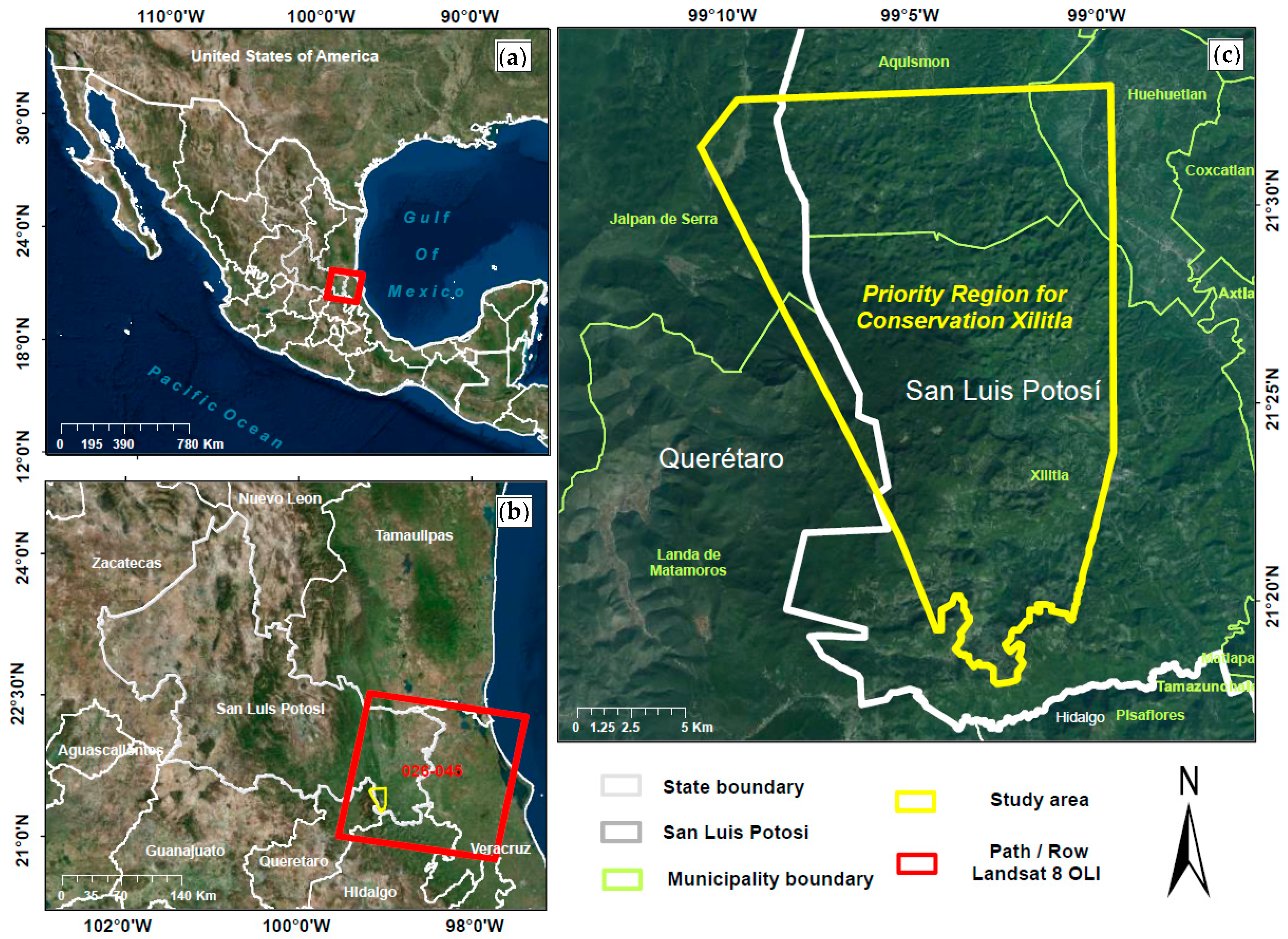
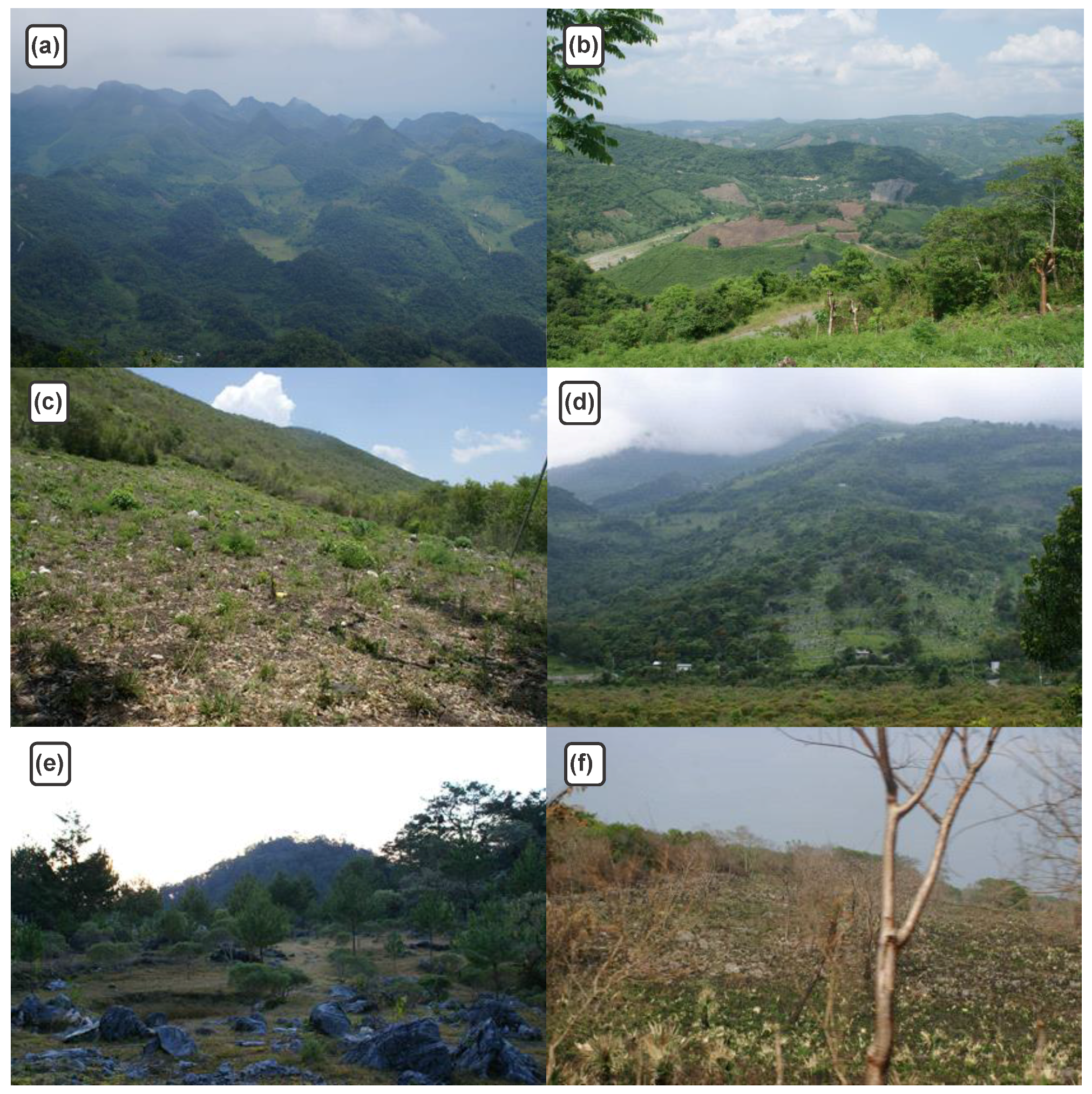
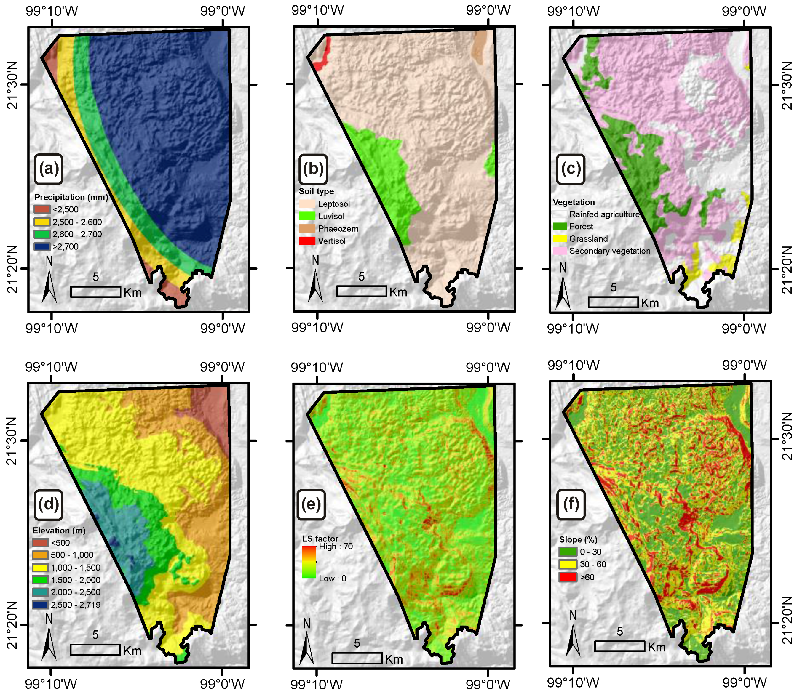
2.1. Study Area
2.2. Methodology
2.2.1. Universal Soil Loss Equation as a Proxy for Soil Degradation Assessment
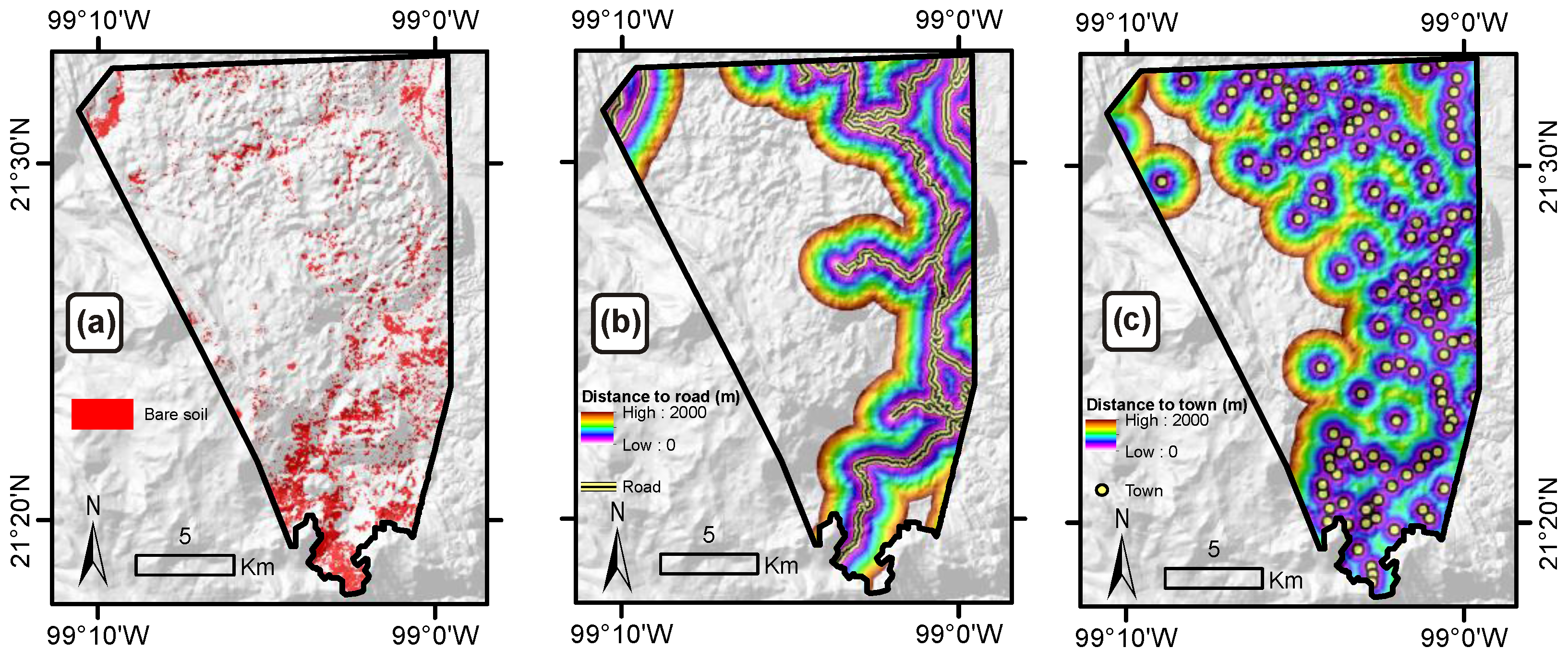
2.2.2. Multi-Criteria Decision Analysis for Determining Feasible Area to Restore
2.2.3. Cross-Tabulation for Determining Priority Land to Restore
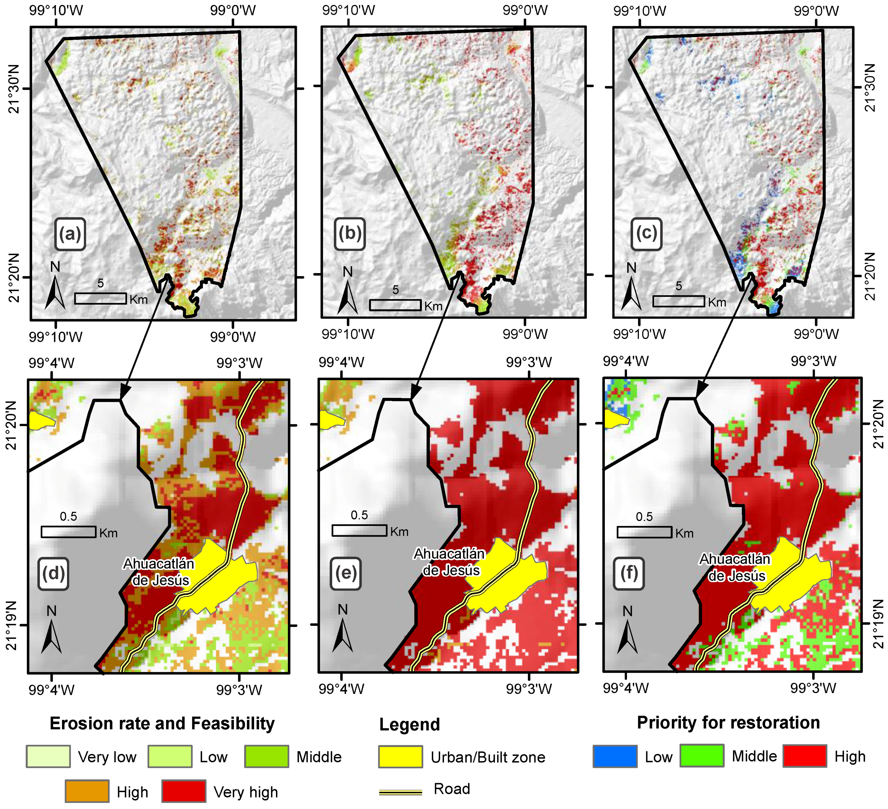
3. Results
4. Discussion
5. Conclusions
Acknowledgments
Author Contributions
Conflicts of Interest
References
- Lal, R. Restoring soil quality to mitigate soil degradation. Sustainability 2015, 7, 5875–5895. [Google Scholar] [CrossRef]
- Muñoz-Iniestra, D.J.; Ferreira-Ramírez, M.; Berenice, E.A.I.; López-García, J. Relación entre la cobertura de suelo y la degradación física y biológica de un suelo aluvial en una región semiárida. Terra Latinoamericana 2013, 31, 201–210. [Google Scholar]
- Ramírez-Carballo, H.; Pedroza-Sandoval, A. Participatory assessment of the soil degradation in Biosphere Reserve Mapimí, Durango, México. Revista Chapingo Serie Zonas Áridas 2007, 6, 247–254. [Google Scholar]
- Vargas Ríos, O. Restauración ecológica: Biodiversidad y conservación. Acta Biológica Colombiana 2011, 16, 221–246. [Google Scholar]
- Yin, R.; Zhao, M. Ecological restoration programs and payments for ecosystem services as integrated biophysical and socioeconomic processes—China’s experience as an example. Ecol. Econ. 2012, 73, 56–65. [Google Scholar] [CrossRef]
- Reddy, C.S.; Manaswini, G.; Satish, K.V.; Singh, S.; Jha, C.S.; Dadhwal, V.K. Conservation priorities of forest ecosystems: Evaluation of deforestation and degradation hotspots using geospatial techniques. Ecol. Eng. 2016, 91, 333–342. [Google Scholar] [CrossRef]
- Adame, M.F.; Hermoso, V.; Perhans, K.; Lovelock, C.E.; Herrera-Silveira, J.A. Selecting cost-effective areas for restoration of ecosystem services. Conserv. Biol. 2015, 29, 493–502. [Google Scholar] [CrossRef] [PubMed]
- Trabucchi, M.; O’Farrell, P.J.; Notivol, E.; Comín, F.A. Mapping ecological processes and ecosystem services for prioritizing restoration efforts in a semi-arid mediterranean river basin. Environ. Manag. 2014, 53, 1132–1145. [Google Scholar] [CrossRef] [PubMed]
- Trabucchi, M.; Comín, F.A.; O’Farrell, P.J. Hierarchical priority setting for restoration in a watershed in NE Spain, based on assessments of soil erosion and ecosystem services. Reg. Environ. Chang. 2013, 13, 911–926. [Google Scholar] [CrossRef]
- Jacobs, D.F.; Oliet, J.A.; Aronson, J.; Bolte, A.; Bullock, J.M.; Donoso, P.J.; Landhäusser, S.M.; Madsen, P.; Peng, S.; Rey-Benayas, J.M.; et al. Restoring forests: What constitutes success in the twenty-first century? New For. 2015, 46, 601–614. [Google Scholar] [CrossRef]
- Shriver, D.M.; Randhir, T.O. Integrating Stakeholder Values with Multiple Attributes to Quantify Watershed Performance. Water Resour. Res. 2006, 42. [Google Scholar] [CrossRef]
- Bana e Costa, C.A.; Antao da Silva, P.; Nunes Correia, F. Multicriteria Evaluation for Flood Control Measures: The Case of Ribeira Do Livramento; The London School of Economics and Political Science: London, UK, 2003. [Google Scholar]
- Borrelli, P.; Panagos, P.; Märker, M.; Modugno, S.; Schütt, B. Assessment of the impacts of clear-cutting on soil loss by water erosion in Italian forests: First comprehensive monitoring and modelling approach. Catena 2017, 149, 770–781. [Google Scholar] [CrossRef]
- Meshesha, D.T.; Tsunekawa, A.; Tsubo, M.; Haregeweyn, N. Dynamics and hotspots of soil erosion and management scenarios of the central rift valley of Ethiopia. Int. J. Sediment Res. 2012, 27, 84–99. [Google Scholar] [CrossRef]
- Duarte, G.T.; Ribeiro, M.C.; Paglia, A.P. Ecosystem services modeling as a tool for defining priority areas for conservation. PLoS ONE 2016, 11, e0154573. [Google Scholar] [CrossRef]
- Thomson, J.R.; Moilanen, A.J.; Vesk, P.A.; Bennett, A.F.; Mac Nally, R. Where and when to revegetate: A quantitative method for scheduling landscape reconstruction. Ecol. Appl. 2009, 19, 817–828. [Google Scholar] [CrossRef] [PubMed]
- Moilanen, A.; Leathwick, J.R.; Quinn, J.M. Spatial prioritization of conservation management. Conserv. Lett. 2011, 4, 383–393. [Google Scholar] [CrossRef]
- Legge, J.T.; Doran, P.J.; Herbert, M.E.; Asher, J.; O’Neil, G.; Mysorekar, S.; Sowa, S.; Hall, K.R. From model outputs to conservation action: Prioritizing locations for implementing agricultural best management practices in a midwestern watershed. J. Soil Water Conserv. 2013, 68, 22–33. [Google Scholar] [CrossRef]
- Richardson, M.S.; Gatti, R.C. Prioritizing wetland restoration activity within a Wisconsin watershed using GIS modeling. J. Soil Water Conserv. 1999, 54, 537–542. [Google Scholar]
- Widis, D.C.; BenDor, T.K.; Deegan, M. Prioritizing wetland restoration sites: A review and application to a large-scale coastal restoration program. Ecol. Restor. 2015, 33, 358–377. [Google Scholar] [CrossRef]
- Mohamed, E.S.; Schütt, B.; Belal, A. Assessment of environmental hazards in the North Western Coast Egypt using RS and GIS. Egypt. J. Remote Sens. Space Sci. 2013, 16, 219–229. [Google Scholar] [CrossRef]
- Teshome, A.; Rolker, D.; de Graaff, J. Financial viability of soil and water conservation technologies in northwestern Ethiopian highlands. Appl. Geogr. 2013, 37, 139–149. [Google Scholar] [CrossRef]
- Mancino, G.; Nolè, A.; Salvati, L.; Ferrara, A. In-between forest expansion and cropland decline: A revised USLE model for soil erosion risk under land-use change in a Mditerranean region. Ecol. Indic. 2016, 71, 544–550. [Google Scholar] [CrossRef]
- Alexandridis, T.K.; Sotiropoulou, A.M.; Bilas, G.; Karapetsas, N.; Silleos, N.G. The effects of seasonality in estimating the C-factor of soil erosion studies. Land Degrad. Dev. 2015, 26, 596–603. [Google Scholar] [CrossRef]
- Malczewski, J. GIS-based land-use suitability analysis: A critical overview. Prog. Plan. 2004, 62, 3–65. [Google Scholar] [CrossRef]
- Stemn, E.; Kumi-Boateng, B.; Sibil, S. Multi-criteria-GIS based site selection for irrigational reservoir—A case study. Eur. Agrophys. J. 2016, 3, 1–17. [Google Scholar] [CrossRef]
- Uribe, D.; Geneletti, D.; del Castillo, R.; Orsi, F. Integrating stakeholder preferences and GIS-based multicriteria analysis to identify forest landscape restoration priorities. Sustainability 2014, 6, 935–951. [Google Scholar] [CrossRef]
- Orsi, F.; Geneletti, D. Identifying priority areas for forest landscape restoration in Chiapas (Mexico): An operational approach combining ecological and socioeconomic criteria. Landsc. Urban Plan. 2010, 94, 20–30. [Google Scholar] [CrossRef]
- Patel, D.P.; Srivastava, P.K.; Gupta, M.; Nandhakumar, N. Decision support system integrated with geographic information system to target restoration actions in watersheds of arid environment: A case study of Hathmati watershed, Sabarkantha district, Gujarat. J. Earth Syst. Sci. 2015, 124, 71–86. [Google Scholar] [CrossRef]
- Rahman, M.R.; Shi, Z.H.; Chongfa, C. Assessing regional environmental quality by integrated use of remote sensing, GIS, and spatial multi-criteria evaluation for prioritization of environmental restoration. Environ. Monit. Assess. 2014, 186, 6993–7009. [Google Scholar] [CrossRef] [PubMed]
- CONANP; GIZ. Programa de Adaptación al Cambio Climático de la Región Central de la Sierra Madre Oriental; Comisión Nacional de Áreas Naturales Protegidas, Deutsche Gesellschaft für Internationale Zusammenarbeit: Mexico City, Mexico, 2013. [Google Scholar]
- Reyes-Hernández, H.; Aguilar-Robledo, M.; Aguirre-Rivero, J.; Trejo-Vázquez, I. Cambios en la cubierta vegetal y uso del suelo en el área del proyecto Pujal-Coy, San Luis Potosí, México. Investigaciones Geográficas 2006, 59, 26–42. [Google Scholar]
- Renard, K.G.; Foster, G.R.; Weesies, G.A.; McCool, D.K.; Yoder, D.C. Predicting Soil Erosion by Water: A Guide to Conservation Planning with the Revised Universal Soil Loss Equation; U.S. Department of Agriculture, Agricultural Research Service: Beltsville, MD, USA, 1997; p. 384.
- Wischmeier, W.H.; Smith, D.D. Predicting Rainfall Erosion Losses. A Guide to Conservation Planning; U.S. Department of Agriculture: Beltsville, MD, USA, 1978.
- Cortés, T.H. Caracterización de la Erosividad de la Lluvia en México Utilizando Métodos Multivariados. Master’s Thesis, Colegio de Postgraduados, Montecillo, Mexico, 1991. [Google Scholar]
- INEGI. Conjunto de Datos Vectoriales Edafológico Escala 1:250,000; Serie II; National Institute of Statistics and Geography (Mexico): Aguascalientes, Mexico, 2006. [Google Scholar]
- Food and Agriculture Organization (FAO). A Provisional Methodology for Soil Degradation Assessment; FAO: Rome, Italy, 1979. [Google Scholar]
- Moore, I.D.; Burch, G.J. Physical basis of the length slope factor in the Universal Soil Loss Equation. Soil Sci. Soc. Am. J. 1986, 50, 1294–1298. [Google Scholar] [CrossRef]
- Moore, I.D.; Burch, G.J. Modeling erosion and deposition: Topographic effects. Trans. Am. Soc. Agric. Eng. 1986, 29, 1624–1630. [Google Scholar] [CrossRef]
- INEGI. Digital Elevation Model at 30 m Spatial Resolution; National Institute of Statistics and Geography: Aguascalientes, Mexico, 2013. [Google Scholar]
- Figueroa, S.B.; Amante, A.O.; Cortes, H.G.T.; Pimentel, J.; Osuna, C.E.S.; Rodríguez, O.; Morales, F.J. Manual de Predicción de Perdidas de Suelo Por Erosión; Secretaria de Agricultura y Recursos Hidráulicos Colegio de Postgraduados: Montecillo, Mexico, 1991; p. 150. [Google Scholar]
- INEGI. Conjunto de Datos Vectoriales de Uso de Suelo y Vegetación, Escala 1:250 000; Serie V (Continuo Nacional); Instituto Nacional de Estadística y Geografia: Aguascalientes, Mexico, 2013. [Google Scholar]
- Parveen, R.; Kumar, U. Integrated approach of Universal Soil Loss Equation and Geographical Information System for soil loss risk assessment in Upper South Koel basin, Jharkhand. J. Geogr. Inf. Syst. 2012, 4, 588–596. [Google Scholar] [CrossRef]
- Correa, S.W.; Mello, C.R.; Chou, S.C.; Curi, N.; Norton, L.D. Soil erosion risk associated with climate change at Mantaro River basin, Peruvian Andes. Catena 2016, 147, 110–124. [Google Scholar] [CrossRef]
- Wilson, S.J.; Cagalanan, D. Governing restoration: Strategies, adaptations and innovations for tomorrow’s forest landscapes. World Dev. Perspect. 2016, 4, 11–15. [Google Scholar] [CrossRef]
- INEGI. Marco Geoestadístico Nacional, 6.2 ed.; Instituto Nacional de Estadística y Geografía: Aguascalientes, Mexico, 2014. [Google Scholar]
- INEGI. Conjunto de Datos Vectoriales de Carreteras y Vialidades urbanas, edición 1.0; Instituto Nacional de Estadística y Geografía: Aguascalientes, Mexico, 2016. [Google Scholar]
- Braid, A.C.; Nielsen, S.E. Prioritizing sites for protection and restoration for grizzly bears (Ursus arctos) in Southwestern Alberta, Canada. PLoS ONE 2015, 10, e0132501. [Google Scholar] [CrossRef] [PubMed]
- Averna-Valente, R.D.O.; Vettorazzi, C.A. Definition of priority areas for forest conservation through the Ordered Weighted Averaging method. For. Ecol. Manag. 2008, 256, 1408–1417. [Google Scholar] [CrossRef]
- Drobne, S.; Lisec, A. Multi-attribute decision analysis in GIS: Weighted Linear Combination and Ordered Weighted Averaging. Informatica 2009, 33, 459–474. [Google Scholar]
- USGS; USDI. Global Visualization (GloVis) Viewer. Available online: https://glovis.usgs.gov/ (accessed on 22 August 2017).
- Ariza, A. Descripción y Corrección de Productos Landsat 8; Instituto Geográfico Agustín Codazzi: Bogotá, Colombia, 2013. [Google Scholar]
- USGS. Using the USGS Landsat 8 Product; United States Geological Survey: Reston, VA, USA, 2016.
- Stević, D.; Hut, I.; Dojčinović, N.; Joković, J. Automated identification of land cover type using multispectral satellite images. Energy Build. 2016, 115, 131–137. [Google Scholar] [CrossRef]
- Mahalingam, B.; Malik, M.M.; Vinay, M. Assessment of soil erosion using USLE technique: A case study of Mysore district, Karnataka, India. J. Remote Sens. GIS 2015, 6, 1–7. [Google Scholar]
- Zhang, X.; Wu, B.; Ling, F.; Zeng, Y.; Yan, N.; Yuan, C. Identification of priority areas for controlling soil erosion. Catena 2010, 83, 76–86. [Google Scholar] [CrossRef]
- Aydin, N.Y.; Kentel, E.; Duzgun, S. GIS-based environmental assessment of wind energy systems for spatial planning: A case study from western turkey. Renew. Sustain. Energy Rev. 2010, 14, 364–373. [Google Scholar] [CrossRef]
- Chang, N.B.; Parvathinathan, G.; Breeden, J.B. Combining GIS with fuzzy multicriteria decision-making for landfill siting in a fast-growing urban region. J. Environ. Manag. 2008, 87, 139–153. [Google Scholar] [CrossRef] [PubMed]
- Fernández, I.C.; Morales, N.S. A spatial multicriteria decision analysis for selecting priority sites for plant species restoration: A case study from the Chilean biodiversity hotspot. Restor. Ecol. 2016, 24, 599–608. [Google Scholar] [CrossRef]
- Comino, E.; Bottero, M.; Pomarico, S.; Rosso, M. Exploring the environmental value of ecosystem services for a river basin through a spatial multicriteria analysis. Land Use Policy 2014, 36, 381–395. [Google Scholar] [CrossRef]
- Bottero, M.; Comino, E.; Duriavig, M.; Ferretti, V.; Pomarico, S. The application of a Multicriteria Spatial Decision Support System (MCSDSS) for the assessment of biodiversity conservation in the province of Varese (Italy). Land Use Policy 2013, 30, 730–738. [Google Scholar] [CrossRef]
- Ferretti, V.; Pomarico, S. Ecological land suitability analysis through spatial indicators: An application of the Analytic Network Process technique and Ordered Weighted Average approach. Ecol. Indic. 2013, 34, 507–519. [Google Scholar] [CrossRef]
- Pijanowski, B.C.; Brown, D.G.; Shellito, B.A.; Manik, G.A. Using neural networks and GIS to forecast land use changes: A land transformation model. Comput. Environ. Urban Syst. 2002, 26, 553–575. [Google Scholar] [CrossRef]
- Mas, J.F.; Puig, H.; Palacio, P.; Sosa, A. Modelado del proceso de deforestación en una región del sureste de México. In Proceedings of the II Seminario Latinoamericano de Geografía Física, Maracaibo, Venezuela, 24–27 July 2002. [Google Scholar]
- Wang, L.; Huang, J.; Du, Y.; Hu, Y.; Han, P. Dynamic assessment of soil erosion risk using Landsat TM and HJ satellite data in Danjiangkou Reservoir Area, China. Remote Sens. 2013, 5, 3826–3848. [Google Scholar] [CrossRef]
- Minaei, M.; Kainz, W. Watershed land cover/land use mapping using remote sensing and data mining in Gorganrood, Iran. ISPRS Int. J. Geoinf. 2016, 5, 57. [Google Scholar] [CrossRef]
- Fedy, B.C.; Doherty, K.E.; Aldridge, C.L.; O’Donnell, M.; Beck, J.L.; Bedrosian, B.; Gummer, D.; Holloran, M.J.; Johnson, G.D.; Kaczor, N.W.; et al. Habitat prioritization across large landscapes, multiple seasons, and novel areas: An example using greater sage-grouse in Wyoming. Wildl. Monogr. 2014, 190, 1–39. [Google Scholar] [CrossRef]
- Sattler, T.; Bontadina, F.; Hirzel, A.H.; Arlettaz, R. Ecological niche modelling of two cryptic bat species calls for a reassessment of their conservation status. J. Appl. Ecol. 2007, 44, 1188–1199. [Google Scholar] [CrossRef]
- Martínez-Harms, M.J.; Quijas, S.; Merenlender, A.M.; Balvanera, P. Enhancing ecosystem services maps combining field and environmental data. Ecosyst. Serv. 2016, 22, 32–40. [Google Scholar] [CrossRef]
- Budiharta, S.; Meijaard, E.; Wells, J.A.; Abram, N.K.; Wilson, K.A. Enhancing feasibility: Incorporating a socio-ecological systems framework into restoration planning. Environ. Sci. Policy 2016, 64, 83–92. [Google Scholar] [CrossRef]
- Marignani, M.; Rocchini, D.; Torri, D.; Chiarucci, A.; Maccherini, S. Planning restoration in a cultural landscape in Italy using an Object-based Approach and historical analysis. Landsc. Urban Plan. 2008, 84, 28–37. [Google Scholar] [CrossRef]
- Jabardo-Pereda, V.; Padilla-y-Sotelo, L.S. Water scarcity in the Huasteca Potosina (México): Local conflicts. Rev. Univ. Geogr. 2016, 25, 133. [Google Scholar]
- SEMARNAT. Consecuencias Sociales del Cambio Climático en México: Análisis y Propuestas; Secretaria del Medio Ambiente y Recursos Naturales: Villahermosa, Mexico, 2009; p. 67. [Google Scholar]
- Miranda-Aragón, L.; Treviño-Garza, E.J.; Jiménez-Pérez, J.; Aguirre-Calderón, O.A.; González-Tagle, M.A.; Pompa-García, M.; Aguirre-Salado, C.A. Modeling susceptibility to deforestation of remaining ecosystems in North Central Mexico with logistic regression. J. For. Res. 2012, 23, 345–354. [Google Scholar] [CrossRef]
- Lambin, E.F. Modelling and monitoring land-cover change processes in tropical regions. Prog. Phys. Geogr. 1997, 21, 375–393. [Google Scholar] [CrossRef]
- Grau, H.R.; Mitchell, T.A.; Zimmerman, J.K.; Thomlinson, J.R.; Helmer, E.; Xioming, Z. The ecological consequences of socioeconomic and land-use changes in postagriculture Puerto Rico. BioScience 2003, 53, 1159–1168. [Google Scholar] [CrossRef]
- CONANP. Management Programs of Natural Protected Areas in Mexico. Available online: http://www.conanp.gob.mx/movil/programas.php (accessed on 13 August 2017).
- Garcia-Alaniz, N.; Equihua, M.; Pérez-Maqueo, O.; Equihua Benítez, J.; Maeda, P.; Pardo Urrutia, F.; Flores Martínez, J.J.; Villela Gaytán, S.A.; Schmidt, M. The Mexican National Biodiversity and Ecosystem Degradation Monitoring System. Curr. Opin. Environ. Sustain. 2017, 26–27, 62–68. [Google Scholar] [CrossRef]
- Pompa-García, M.; González-Cásares, M.; Acosta-Hernández, A.; Camarero, J.; Rodríguez-Catón, M. Drought influence over radial growth of mexican conifers inhabiting mesic and xeric sites. Forests 2017, 8, 175. [Google Scholar] [CrossRef]
- An, S.-S.; Darboux, F.; Cheng, M. Revegetation as an efficient means of increasing soil aggregate stability on the Loess Plateau (China). Geoderma 2013, 209–210, 75–85. [Google Scholar] [CrossRef]
- Peralta-Rivero, C.; Galindo-Mendoza, M.G.; Contreras-Servín, C.; Algara-Siller, M.; Mas-Caussel, J.F. Local perception regarding to the environmental assessment and loss of forest resources in the Huasteca Region of San Luis Potosi, Mexico. Madera y Bosques 2016, 22, 71–93. [Google Scholar]
- Sayer, J.A.; Margules, C.; Boedhihartono, A.K.; Sunderland, T.; Langston, J.D.; Reed, J.; Riggs, R.; Buck, L.E.; Campbell, B.M.; Kusters, K.; et al. Measuring the effectiveness of landscape approaches to conservation and development. Sustain. Sci. 2016, 12, 465–476. [Google Scholar] [CrossRef]
- Sanchez-Cuervo, A.M.; Aide, T.M. Identifying hotspots of deforestation and reforestation in Colombia (2001–2010): Implications for protected areas. Ecosphere 2013, 4, 1–21. [Google Scholar] [CrossRef]


| Soil Type | Soil Texture | ||
|---|---|---|---|
| Sand | Silt | Clay | |
| Leptosol | 0.053 | 0.079 | 0.026 |
| Luvisol | 0.053 | 0.079 | 0.026 |
| Phaeozem | 0.026 | 0.040 | 0.013 |
| Vertisol | 0.053 | 0.079 | 0.026 |
| Soil Degradation Assessment by Using USLE | |||||||
|---|---|---|---|---|---|---|---|
| Very Low | Low | Middle | High | Very High | |||
| 1 | 2 | 3 | 4 | 5 | |||
| Feasibility using MCDA | Very low | 1 | - | - | - | - | - |
| Low | 2 | - | - | - | - | - | |
| Middle | 3 | - | - | Low priority | Low priority | Low priority | |
| High | 4 | - | - | Middle priority | Middle priority | High priority | |
| Very high | 5 | - | - | Middle priority | High priority | High priority | |
| Level | Soil Erosion Rate USLE (ha) | Feasibility MCDA (ha) |
|---|---|---|
| Very low | 27.0 | 70.4 |
| Low | 309.3 | 125.7 |
| Middle | 939.3 | 957.0 |
| High | 1955.4 | 961.2 |
| Very high | 995.7 | 2112.4 |
| Total | 4226.7 | 4226.7 |
| USLE | MCDA | Priority | Area (ha) | Priority | Area (ha) | |
| 1 | 1 | - | 3.6 | Low | 858.15 | |
| 1 | 2 | - | 3.8 | Middle | 869.67 | |
| 1 | 3 | - | 3.1 | High | 2000.52 | |
| 1 | 4 | - | 17.0 | Total | 4019.04 | |
| 2 | 1 | - | 19.5 | |||
| 2 | 2 | - | 7.5 | |||
| 2 | 3 | - | 95.7 | (c) | ||
| 2 | 4 | - | 186.4 | Code for USLE/MCDA | Description | |
| 3 | 1 | - | 47.8 | 1 | Very low | |
| 3 | 2 | - | 12.1 | 2 | Low | |
| 3 | 3 | Low priority | 304.3 | 3 | Middle | |
| 3 | 4 | Middle priority | 154.6 | 4 | High | |
| 3 | 5 | Middle priority | 420.3 | 5 | Very high | |
| 4 | 2 | - | 94.41 | |||
| 4 | 3 | Low priority | 542.0 | |||
| 4 | 4 | Middle priority | 294.7 | |||
| 4 | 5 | High priority | 1024.2 | |||
| 5 | 2 | - | 7.74 | |||
| 5 | 3 | Low priority | 11.7 | |||
| 5 | 4 | High priority | 308.3 | |||
| 5 | 5 | High priority | 667.9 | |||
| Total | 4226.7 |
© 2017 by the authors. Licensee MDPI, Basel, Switzerland. This article is an open access article distributed under the terms and conditions of the Creative Commons Attribution (CC BY) license (http://creativecommons.org/licenses/by/4.0/).
Share and Cite
Aguirre-Salado, C.A.; Miranda-Aragón, L.; Pompa-García, M.; Reyes-Hernández, H.; Soubervielle-Montalvo, C.; Flores-Cano, J.A.; Méndez-Cortés, H. Improving Identification of Areas for Ecological Restoration for Conservation by Integrating USLE and MCDA in a GIS-Environment: A Pilot Study in a Priority Region Northern Mexico. ISPRS Int. J. Geo-Inf. 2017, 6, 262. https://doi.org/10.3390/ijgi6090262
Aguirre-Salado CA, Miranda-Aragón L, Pompa-García M, Reyes-Hernández H, Soubervielle-Montalvo C, Flores-Cano JA, Méndez-Cortés H. Improving Identification of Areas for Ecological Restoration for Conservation by Integrating USLE and MCDA in a GIS-Environment: A Pilot Study in a Priority Region Northern Mexico. ISPRS International Journal of Geo-Information. 2017; 6(9):262. https://doi.org/10.3390/ijgi6090262
Chicago/Turabian StyleAguirre-Salado, Carlos Arturo, Liliana Miranda-Aragón, Marín Pompa-García, Humberto Reyes-Hernández, Carlos Soubervielle-Montalvo, Jorge Alberto Flores-Cano, and Heriberto Méndez-Cortés. 2017. "Improving Identification of Areas for Ecological Restoration for Conservation by Integrating USLE and MCDA in a GIS-Environment: A Pilot Study in a Priority Region Northern Mexico" ISPRS International Journal of Geo-Information 6, no. 9: 262. https://doi.org/10.3390/ijgi6090262
APA StyleAguirre-Salado, C. A., Miranda-Aragón, L., Pompa-García, M., Reyes-Hernández, H., Soubervielle-Montalvo, C., Flores-Cano, J. A., & Méndez-Cortés, H. (2017). Improving Identification of Areas for Ecological Restoration for Conservation by Integrating USLE and MCDA in a GIS-Environment: A Pilot Study in a Priority Region Northern Mexico. ISPRS International Journal of Geo-Information, 6(9), 262. https://doi.org/10.3390/ijgi6090262