Article

Addressing Public Law Restrictions within a 3D Cadastral Context

School of Rural and Surveying Engineering, National Technical University of Athens (NTUA), Athens 15780, Greece
*
Author to whom correspondence should be addressed.
ISPRS Int. J. Geo-Inf. 2017, 6(7), 182; https://doi.org/10.3390/ijgi6070182
Submission received: 5 April 2017 / Revised: 29 May 2017 / Accepted: 18 June 2017 / Published: 22 June 2017
(This article belongs to the Special Issue Research and Development Progress in 3D Cadastral Systems)

Abstract

:
Public law affects contemporary life by imposing various regulations that apply in 3D space. However, such restrictions are either literally described in legal documents or presented on a horizontal plane, resulting in ambiguities, especially in the case of vertically overlapping restrictions with a significant impact on land management. This paper investigates public law restrictions (PLR) applying to 3D space and their management within a 3D cadastral context. Within this framework, a case study is examined in Greece concerning the establishment of a subway station, focusing on public utilities, archaeological legislation, and building regulations. Relative legal documentation is compiled and mapped in a 3D PLR model, presenting inefficiencies and malfunctions that can be resolved if PLRs are addressed within a 3D cadastral context. Stipulations implying restrictions in 3D space within current legislation are presented, along with the restrictions deriving from the absolute character of ownership right, thus highlighting the significance of 3D definition, modeling and recording of PLRs.

1. Introduction

The rapid expansion in urban areas over the years forced the vertical exploitation of real property, both for accommodation purposes and to respond to emerging public needs related to the amenities required by modern societies [1,2]. Technological advances in the field of construction address such needs, through the development of complex, overlapping, and interlocking structures. Furthermore, the development of surveying techniques as well as of information and computer technology provides the means for high-accuracy 3D data acquisition, modeling, and management. Research has extended to 3D/4D and even 5D representations, which is also available in the literature [3,4], taking into account aspects such as time and scale.
The exploitation of real property is regulated by national legal frameworks, based on Roman principles of real property, specifically regulated to address overlapping private and public rights. Public law restrictions (PLR) significantly impact contemporary life [5]. The 3D aspects of PLRs related to mineral activities, archaeology, environment, civil aviation, urban planning, building regulations, and utilities are presented in [6]. Despite the steadily growing effect of legal regulations applying to 3D space, the interest of legal professionals in 3D Cadastre issues remains limited [7,8]. Legal professionals’ lack of interest mainly derives from: (a) the existence, until recently, of limited cases that would require a 3D cadastral approach; (b) the use of limited real rights and condominium concepts or; (c) the establishment of specific legislation to regulate large-scale underground infrastructures. This results in considerable complexities regarding land management and structural activities, thereby leading to costly and time-consuming judicial procedures. It can be concluded that the legislative regulation of subsoil is required in order to address emerging conflicts [9].
Taking into account technological abilities in 3D modeling and management, the variety of PLRs on land can be modelled to benefit the public, professionals and land administrators. Combined with advances in the field of web geographic information systems (GIS), high-quality 3D objects’ visualization and management in web-based platforms can be provided. Within the field of 3D Cadastre, [10] a web-based 3D visualization prototype for both legal and physical 3D real property objects’ space has been developed. The documentation and management of PLRs is becoming a complex issue, as they are defined by various legal documents, which also need to apply to specific volumes of space, dividing the absolute character of ownership rights, which is not familiar to traditional legal thinking. Efficient modeling and visualizing of PLRs can only be achieved if operating in combination with cadastral systems in a multipurpose approach, contributing to land administration, decision-making, and development. To this aim, [11] proposed the 3D Cadastral Domain Model (3DCDM), providing “a framework to identify 3D Cadastre and clarify its scope”.
Research interest in 3D PLRs mostly focuses on specific fields, e.g., utility networks. The legal, organizational, and technical implications of 3D and 4D Cadastres, focusing on utility networks in three countries, are examined in [12], while [13] presents a 4D Cadastre prototype implemented on a case study in the Netherlands. In [14], the implementation of the first 3D cadastral registration of multi-surface real property rights in the Netherlands to a multi-surface complex, including a railway station, municipal offices, underground parking and commercial uses, based on existing legal and cadastral framework, is presented. Considering cases of underground infrastructure, [15] propose a 3D underground cadastral data model, specialized in Korean legal framework, based on the Land Administration Domain Model (LADM). Themed cadastres recording specific types of PLRs are established in many countries, particularly in Europe [16]. However, such repositories are 2D based, not interrelated with centralized cadastral systems, nor with other relative databases. Therefore, the full extent of applying restrictions, even on surface parcels, cannot be depicted. In Switzerland, the establishment of a PLR Cadastre, recording 17 types of restrictions classified in 8 fields, has been in progress since 2014, while already operating in 8 pilot cantons [17]. The possibility of introducing a 3D PLR Cadastre in the canton of Geneva in Switzerland, featuring emerging legal and technical obstacles required to be accommodated for the implementation of such a transition, is investigated in [18].
Emerging Building Information Modeling (BIM) technology provides for semantically rich and detailed 3D building models. Combining this with 3D GIS that enable the establishment of 3D spatial relations and querying, can contribute to 3D Cadastre purposes, especially in the field of PLR management as presented in [19].
This paper continues the research work that was presented at the 5th International Workshop on 3D Cadastres [6], further examining the range of PLRs with 3D aspects that have an impact on real property. Within this context, the 3D nature of specific PLRs is presented, as well as their interrelation to legal and cadastral framework, highlighting resulting deficiencies on land management. This paper explores overlapping PLRs deriving from construction restrictions, archaeology, and public utilities legislation that apply to an area of the city of Thessaloniki in Greece. The paper is structured as follows: Section 2 sets the legal background of PLRs in Greece, starting from general stipulations by the Greek Constitution, archaeological legislation, as well as legislation on public utilities. Analysis focuses on the legal framework regulating the development of Thessaloniki’s subway in order to create the 3D model of associated PLRs, based on their descriptive legal documentation. Section 3 presents the results of the implementation of 3D related PLRs on the examined case study. In Section 4, different types of PLRs and their association with 3D cadastral concepts are discussed and analyzed, in the light of case study’s results. Issues of further research are also discussed in this section. The paper ends with some concluding remarks on the deficiencies on land administration due to the lack of 3D PLRs and the benefits of implementing such a concept (Section 5).

2. Materials and Methods

In this section, 3D PLRs derived from archaeological regulations, public utilities’ regulations, and building regulations that apply in Greece are presented and analyzed, depicting the need of stratification of rights, restrictions and responsibilities (RRRs). The above-mentioned 3D PLRs are modelled in 3D to a case study regarding the establishment of Thessaloniki’s city subway line. In order to model in 3D these PLRs, Autodesk AutoCAD software version N.52.0.0 [20] has been used. The 3D model generated depicts 3D real property stratification of the examined PLRs, which is further compared to the models of existing repositories, in order to present deficiencies and malfunctions that need to be addressed by 3D Cadastre legislation.

2.1. Legal Framework

This subsection sets the legislative background in Greece, by presenting the basic characteristics pertaining to Greek legislation on Archaeology, public utilities and infrastructures, as well as building regulations. Section 2.2 presents relative legal documentation and “transforms” descriptive legal stipulations to 3D volumes of rights and restrictions.

2.1.1. Constitutional Regulations

The Greek Constitution explicitly provides for the protection of property (Art. 17, par. 1), while in the case of duly proven public benefit, property can be deprived from its owner under compensation (par. 2). However, works of evident public utility serving public benefit, e.g., “digging of underground tunnels at appropriate depth”, may be allowed by law without compensation “on condition that normal exploitation of the property situated above shall not be hindered” (par. 7). Ownership and disposal of, inter alia, mines, quarries, archaeological sites and underground resources is stipulated to be regulated by special laws (Art. 18, par. 1). Par. 4 also allows for other “necessary deprivation of free use and enjoyment of property”, under special circumstances, which will be provided by law.
On the other hand, Art. 24 (par. 6) sets monuments, historic areas and elements under protection of the State stipulating that “a law shall provide for measures restrictive of private ownership…as well as the manner and the kind of compensation payable to the owners”.

2.1.2. Archaeological Legislation

The protection of cultural heritage is a field of public law that applies to 3D space, as it is related to the protection of underground and maritime antiquities. Thus, it is strongly related to 3D Cadastre, as stratification of real property or the application of 3D restrictions on real property facilitate archaeological research, as well as underground antiquities’ protection and management. 3D aspects of cultural heritage protection have been considered, yet since 1956, UNESCO’s Recommendations on International Principles Applicable to Archaeological Excavations has recommended that each member state should “Define the legal status of the archaeological sub-soil and, where State ownership of the said sub-soil is recognized, specifically mention the fact in its legislation”.
In Greece, a dense legal fabric has been woven over the years for the protection of archaeological sites and monuments. Archaeological legislation in Greece does not provide for 3D restrictions or responsibilities on real property. However, even in the case that archaeological restrictions apply in height or depth, real property stratification does not take place, as involved parcels are expropriated. In this subsection, characteristic archaeological legislation implying 3D aspects is presented.
Law 3028/2002 constitutes the cornerstone of Greek archaeological legislation, combining regulations established by legislation dating from 1893 and adjusting it to the socioeconomic and cultural environment of modern Greece [21]. It stipulates restrictions on the exploitation of mines and quarries, restrictions on activities that may destroy or damage monuments (Art. 10), and imposes regulations on agricultural, farming and building activities (Art. 13) under relative Ministerial Orders. Article 14 forbids structural activities in settlements within archaeological sites without a license issued under Ministerial Order. Furthermore, it stipulates special regulations regarding ownership restrictions, building and land use, building regulations and permitted activities (par. 6). It also provides for temporary deprivation, use restrictions or even expropriation of real property under compensation to the landowners (Art. 19).
Law 2833/2000 allows for the expropriation or establishment of rights in rem by purpose of public benefit on necessary real property in order to facilitate constructions aiming to unify Athens archaeological sites (Art. 4). Although this law focuses on the city of Athens, considering city’s dense population along with its rich archaeological background, it greatly impacts Athens’s vertical expansion and intensifies the need of real property stratification and management.
The Decree of 29 July 1999 (Official Gazette D’/580) provides for special restrictions on historic buildings or on their neighboring buildings to ensure their protection and promotion. No reference on the type of these restrictions is made. The exception is the provision of transfer of built surface ratio in the case that existing restrictions inhibit its complete exploitation.
Law 5351/1932 sets a zone of 500 m around ancient monuments where mining is forbidden without license issued by the Ministry of Culture and Sports. Establishment of this zone does not directly constitute 3D restriction on real property; however, it is based both on monuments’ protection from mining activities and on the protection of other ancient antiquities that may be traced within this region’s subsoil.

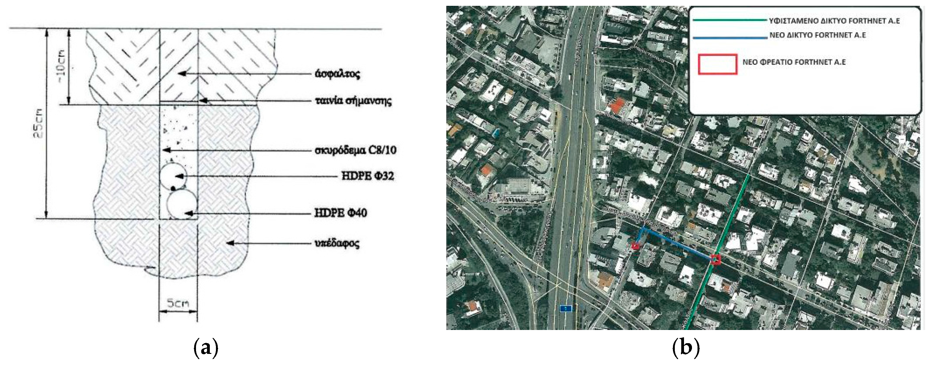
2.1.3. Legislation on Public Utilities

General stipulations on the establishment of public utilities can be traced in the Greek Civil Code (Art. 1031), providing for the establishment of aerial or underground rights of way. Articles 1126 and 1127 define, respectively, the servitude of preserving structures situated on servient parcel and the servitude of preserving structures on another structure that is situated on a servient parcel. The performance of specialized construction works of significant importance is regulated by specific legislation to facilitate projects’ implementation, to deviate from special clauses and to secure concessionaires’ established rights [22]. An adaptation of Law 3389/2005 addresses issues requiring ratification of concession agreements by law, therefore such ratification is no longer necessary.
The establishment of utility servitudes for underground networks such as cables and pipelines is separate from utilities, as utilities are installed deeper and require more extensive construction works, e.g., subway lines. The former are regulated through Joint Ministerial Decision 725/23 (Official Gazette 5/B’/05 January2012), while the latter are established under individual laws, as mentioned above, also regulating procedures related to the discovery of archaeological findings during construction works. To facilitate the construction of utilities while also ensuring monuments’ preservation, Law 4072/2012 provides for agreement between the Ministry of Culture and Sports and bodies undertaking construction works to a memorandum of understanding on archaeological research and excavations, while an individual interministerial committee has been established, addressing conflicts during the construction of infrastructure.
Figure 1 presents extracts from municipal granting of right of way for telecommunications network. The issuing of such a grant requires that agencies responsible for each network submit a drawing or extract of city/master plan, indicating the network’s planned location (defining the position of ditches, drains or aerial networks by their street address and network’s height or depth), along with typical cross sections (Joint Ministerial Decision 725/23).

2.1.4. Building Regulations
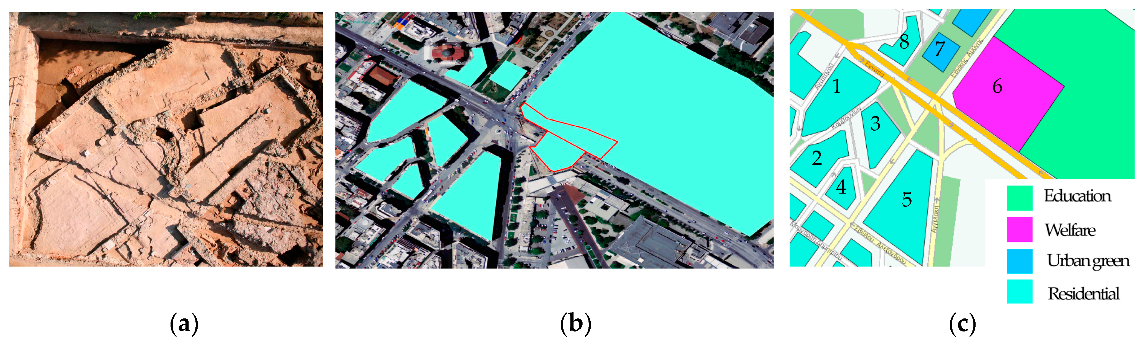
Building regulations stipulate allowed building height, depending on land parcel’s location and area, as well as the building’s intended use, thus defining the permitted building volume. Given the need to reduce energy consumption, building codes also define regulations regarding buildings’ lighting, ventilation, and solar exposure pertaining to 3D aspects, and are influenced by constructions on 3D space, e.g., the shadow cast by a building onto neighboring buildings. Such regulations, combined with energy requirements of already built constructions, can also be used to export buildings’ energy demands in urban areas, which can be further exploited within urban planning regulations.
Additionally, where urban landscape protection is required, specific building regulations apply to protect traditional architectural characteristics of buildings, e.g., facades or interior design [6].

2.2. Study Area

The above-mentioned legislative framework of PLRs is examined through a case study in the city of Thessaloniki in Northern Greece. Thessaloniki bears a longstanding history, established by 315 B.C. Due to the significance of its Paleochristian and Byzantine monuments it has been placed on UNESCO’s World Heritage list since 1988 [24]. Thessaloniki’s archaeological and historical significance, along with its leading character in the region of Macedonia in Northern Greece, result in the need for stratified land exploitation, especially in the field of construction projects.
To protect archaeological antiquities, subway tunnels were designed to be constructed at a depth of 14–31 m, while according to the archaeological report that was compiled, three stations have been characterized as being of “high archaeological risk” and other three of “medium archaeological risk” [25], as presented in Figure 2. However, Thessaloniki’s long-standing history does not ensure that no other archaeological findings would be found within the rest parts of designated subway line. Construction works started in 2006 and are expected to be completed by 2020, while the discovery of significant archaeological findings has resulted in delays to the project’s completion due to administrative and judicial procedures by the government, municipal authorities, archaeologists and the public regarding archaeological findings’ protection and management.

2.2.1. Legislation on the Establishment of the Subway Line

The establishment of Thessaloniki’s subway line is regulated by Law 2714/1999, which constitutes the concession contract between the Greek State and the concessionaire company. The aforementioned concession contract was not put into force and it was decided that the whole project be implemented in the form of public infrastructure. However, its regulations are exploited within this work as the project’s implementation followed similar requirements.
Article 5 of this concession defines real property rights during the concession period. Specifically, the Greek state grants “the right of exclusive use and possession of the totality of surface and underground spaces with adequate access thereto…”, while it is also obliged not to encumber such real property by rights of any nature that may affect, limit or infringe the concessionaire’s rights on the subway’s construction, access or maintenance. In case of private real estate properties that are necessary for the carrying out of the subway’s construction, the law provides for their expropriation at the expense of the Greek state (Art. 5, par. 2, indent 2). Indent 4 regulates rights relating to the boring of underground tunnels. It allows for executing related works without compensation of surface properties, “provided that the current use of subject properties is not affected by such boring”, while the state guarantees that all parties that have rights on surface parcels are obliged to permit and withstand the boring of underground tunnels and of “any work or annoyance necessary for their construction, use, repair and maintenance”.
Article 11 of the Law 2714/1999 also provides for antiquities and the protection of cultural heritage. However, regulations mainly focus on compensation issues, as well as on changes in workflow to facilitate archaeological research and not on imposing, stratified or even planar, restrictions or responsibilities on affected real property. During construction works, the ruins of an old Christian basilica were traced, Figure 3a, which has halted construction in order for the necessary archaeological excavations to be performed. Finally the station has been redesigned in order to preserve the basilica after the decision for its preservation in situ was made by the Central Archaeological Council.
The existence of public utilities hindering subway construction works is regulated in Article 19, which stipulates that the service responsible for pipes or network of pipes that hinder construction works is obliged to assist the concessionaire in their relocation by issuing the necessary permits.

2.2.2. Building Regulations

There has been a significant amount of legal documentation regulating constructions over the years. This complicates access to building regulations, as their availability depends on the level of each municipality’s spatial data infrastructure.
Within this work, access to building regulations was facilitated by Thessaloniki’s municipal geoportal that provides detailed inventory of building regulations applying to city’s building parcels, also referring to relative legal documentation and amendments. Related legal documents include the Presidential Decree defining built-surface ratio, the building codes of 1973 and 1985, and the new building code of 2012, defining building maximum height, and more than 10 town planning decrees regulating land use, land parcels’ geometry and size, declaration of historic buildings, etc. In order not to disclose personal data, land parcellation, as well as existing buildings’ footprints, were retrieved as presented in the Geographical Information portal of the Thessaloniki municipality.

2.2.3. Drawings and Basemaps

Apart from literal legal stipulations, the following drawings and basemaps of the case study area were used to model relative PLRs in 3D:
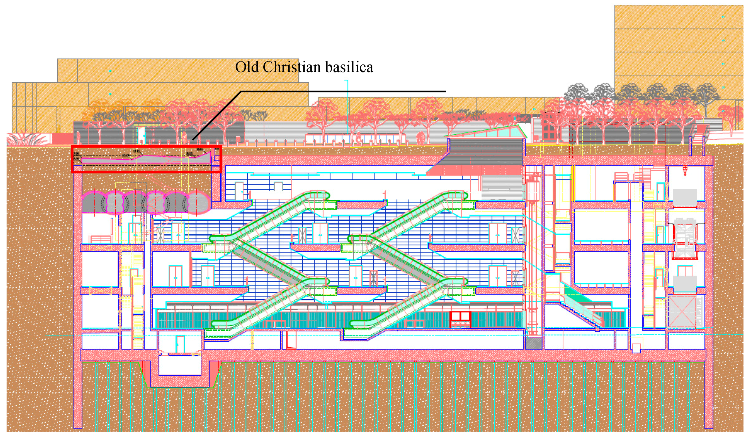
  • Longitudinal section drawing of subway station, provided by Attiko Metro S.A. (Athens, Greece) (Figure 4).
  • Base maps of Thessaloniki presenting land use and building regulations on each building parcel in the Hellenic Geodetic Reference System (HGRS87), available at the repository of Greek government agencies’ databases [29] and the geoportal of the Thessaloniki municipality [28] (Figure 3b).
Apart from the above, it needs to be noted that the Hellenic Cadastre only records 2D land parcellation, buildings’ footprints and servitude zones of passage as projections in the horizontal plane, while there is no provision of either underground or aboveground infrastructures, nor of public law restrictions (PLRs). Therefore, there can be no geographical or topological interrelation between cadastral land parcels, (legal/non-materialized) PLR 3D volumes, and physical 3D infrastructure and constructions’ volumes.

3. Results

Based on the above documentation the 3D model of PLR volumes has been generated, as presented in Figure 5. 3D modeling of the subway station, the subway line, and legal building volumes not only clarifies the relations between different objects and of the rights establishing each object, but also allows for a concise, clear and complete presentation of their internal relations with the rest of the restrictions imposed by public law in the examined area. Findings of the preceding analysis are the following:
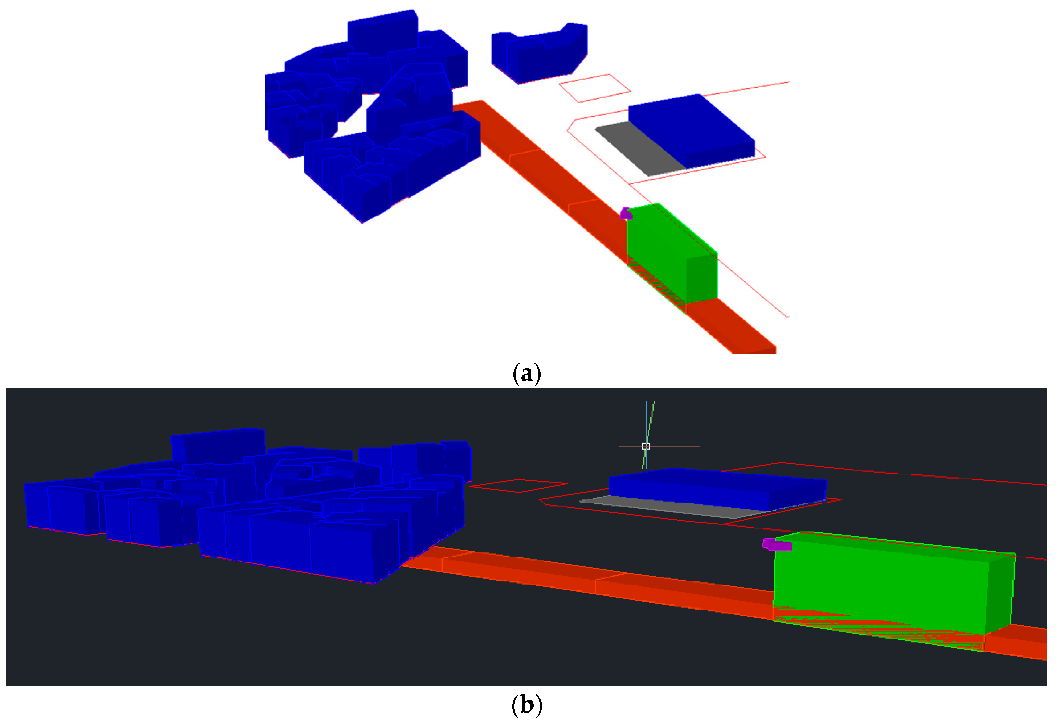
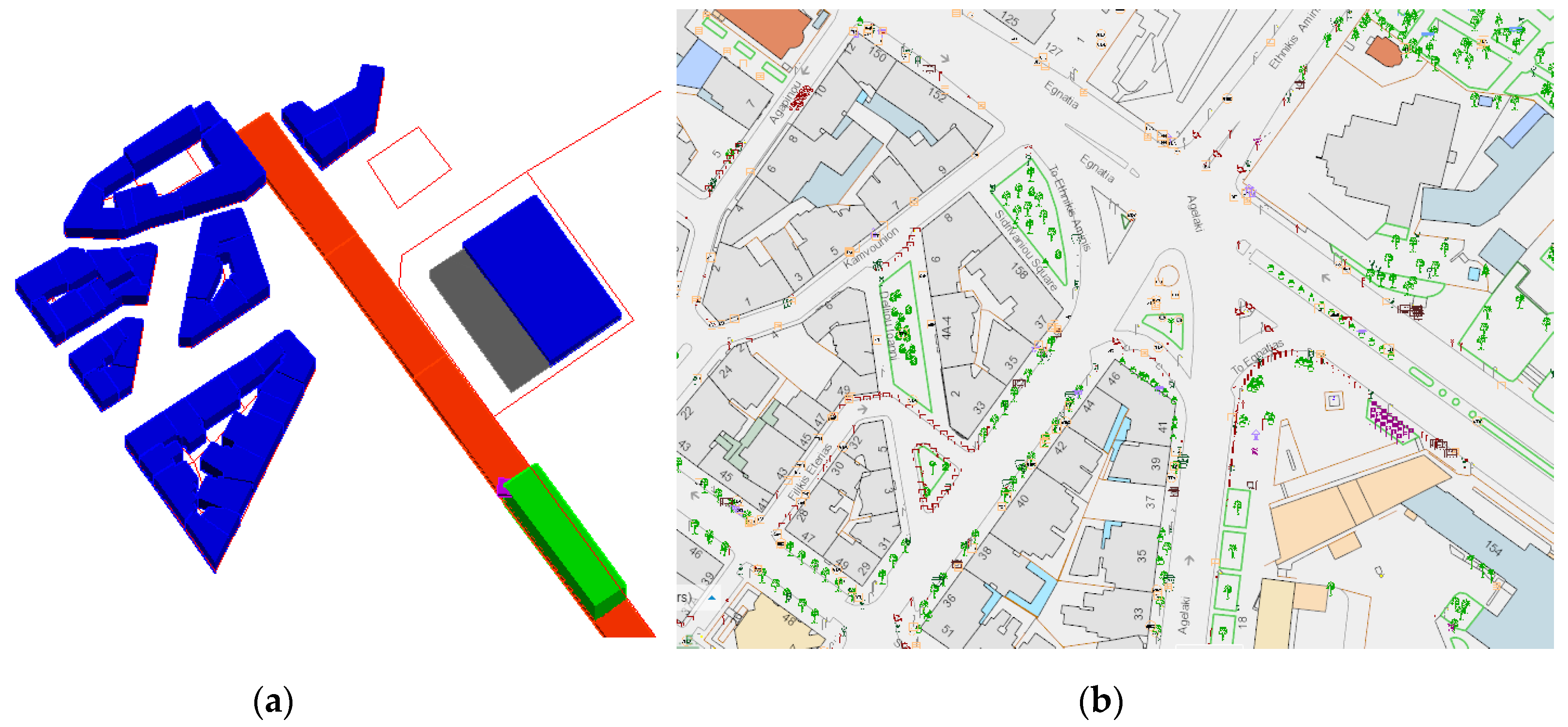
  • As PLRs constitute mainly legal (not materialized, invisible) spaces, their presentation in 3D maps, combined with general stipulations on the vertical extent of ownership, makes it possible to address ambiguities of RRRs’ application in 3D space. Furthermore, 3D presentation of PLRs allows interested parties to understand the interrelation between different legal spaces or legal and physical spaces, as well as each one’s impact on the other. This can also be derived from the examined case study, comparing the exported 3D model with existing cadastral and spatial data recordings that are presented in Figure 6. Cadastral documentation only presents land parcels on the examined area, along with the real property rights that apply to them in 2D, while no reference is made to the archaeological restrictions imposed. In case of real property expropriation for archaeological purposes, registration of the related administrative acts is required. Similarly, the municipal geoportal is limited in presenting the different building types, also including land parcels and building blocks. Places of archaeological interest are only presented as points.
  • As mentioned above, current legislation cannot address complex situations of overlapping RRRs, given both the absolute character of the right of ownership and legal concentration on land parcels as 2D entities. This is also clear within the examined case study, as protection of the archaeological findings traced within the course of the subway line resulted in a long juridical dispute which has also led to delay in the project’s completion.
  • Current recording of archaeological PLRs mostly focuses on monuments or places of archaeological interest and not on the restrictions that are imposed on land. Even when such provision exists, it is limited to restrictions in the horizontal plane. In the examined case study, the combination of the archaeological reports on the designated subway route with establishment of 3D archaeological protection zones would accelerate the resolving of differences regarding preservation in situ, burial, or the relocation of monuments.
  • 3D modeling of PLRs required the compilation of a variety of legal and cartographic documentation not available from a single source. Furthermore, given the significant number of legal amendments, tracing all legal documents related to a specific PLR or to a specific PLR applying to a specific region can become a difficult task.
  • The implementation of 3D PLR models allows for the detailed representation of the legal space where each PLR applies, which contributes to non-ambiguous presentation of rights on land. Results of the 3D model of the examined case study, in contrast to existing cartographic documentation (Figure 6), clearly present differences in the delimitation of each real property, occupied 3D space by physical objects or 3D space encumbered by legal regulations. It needs to be noted that Greek subways are mainly established below state, municipal, or common use space, otherwise the involved, privately owned land parcels are expropriated by the state. Therefore, the whole process is facilitated as it is not affected by complications deriving from co-ownership of land parcels or limited real rights that may be imposed on land. It is evident that efficiency of 3D models would be significantly increased if combined with 3D subdivision or the encumbering of real property.

4. Discussion

In this section, legal areas previously examined are discussed. Deficiencies in land management that relate to PLRs with vertical aspects, as derived by the current legal and cadastral framework, are presented, along with options that 3D PLRs may provide.

4.1. Constitutional Regulations

  • Constitutional stipulations on the protection of ownership need to be brought in line with stipulations concerning the exploitation of mines, quarries, underground resources, archaeological sites and monuments. The Greek Constitution sets the criterion of public benefit to either deprive privately owned land, or to oblige parcel owners to withstand boring activities that do not inhibit normal exploitation of surface parcel real property. Legislation on establishment of infrastructures, as well as Greek Civil Code, are in accord with constitutional stipulations. However, there is no specific definition of “normal exploitation” of real property. When the exploitation of a real property over a public utility needs to expand at a new, greater depth, this results either in the cancelling of planned exploitation, or in the expropriation of the surface parcel.
  • In combination with the above, although the agencies responsible for the establishment and management of underground utilities benefit from their exploitation, surface parcel owners face restrictions on exercising to the fullest extent their ownership rights with no relative benefit.
  • On the other hand, constitutional stipulations, both in article 18 and 24, as mentioned in Section 2.1.1, set the scene for stratification of real property, as they refer to “other necessary deprivation of free use and enjoyment of real property”, as well as to provisions of “restrictive measures of private ownership necessary”. Delays in infrastructure projects derive from the lack of expropriation funds, as well as from the reluctance of (surface) parcel owners to be deprived of their property (or objections to compensation values). This can be more easily addressed with restrictions that apply in 3D space providing for volume expropriation.

4.2. Archaeological Legislation

Archaeological legislation poses restrictions based on horizontal plane. Restrictions applying to 3D space can be traced to regulations regarding underwater antiquities, where protection zones can be established in their vicinity, forbidding or regulating specific types of activities. Archaeological regulations applying vertically are implied by relative legislation under the stipulation of “special regulations” or temporary deprivation of real property. However, these stipulations are not explicitly defined and described, while even such cases are addressed through land expropriation.
With the establishment of archaeological 3D PLRs on the other hand, registration of “restricted” volumes due to underlying antiquities would allow for exploitation of land parcel’s parts that are not lying above archaeological antiquities. This would reduce land expropriation cost and facilitate interrelation with other 3D PLRs, e.g., the establishment of utility networks.
Given the complexities related to archaeological research, the stratification of real property and the imposition of specific RRRs on different land volumes may not resolve all types of emerging legal or technical conflicts on land exploitation. However, it can contribute, particularly in cases where archaeological findings need to be preserved within infrastructures or urban environment.

4.3. Public Utilities

The establishment of public utilities constitutes a field that is strongly related to 3D Cadastre. Regardless of their extent, height or depth, utilities are installed in 3D space, affecting nearby structures in the form of restrictions for installation, repairing, maintenance, protection, and securing of public health. The 3D space affected by public utilities is also related to other PLRs applying to 3D space, e.g., drone flights within a region where rights of way have been granted for passage of above ground powerlines.
The installation of cross-boundary public utilities is in most cases established through utility servitudes or servitudes of passage [2]. In case of pipelines or powerlines, building and agriculture restrictions apply to a specific distance from pipeline’s or powerline’s center-line. Such restrictions apply to building depth and height, cultivation restrictions, as well as the establishment of utility servitudes to allow access and maintenance of the utility. In such cases, compensation of the surface parcel owner [6] is provided. However, there is no provision of recording the content of relative restrictions or their delimitation in 3D space.
Apart from the lack of 3D data on public utilities’ location and volume, their incorporation to cadastral infrastructure is partial: Servitudes of passage are registered by their projection on surface parcels, while the servitude’s type is recorded in the descriptive cadastral database. Therefore, the exact location and extent of servitudes in 3D space, as well as the restrictions imposed on servitudes’ zone, are not available. Internationally, similar issues on registering public utilities are presented by [12,13,30], noting that either servitudes on privately owned land require to be recorded, or that only land parcels encumbered by servitudes are recorded. This results in a lack of information on utilities’ location and extent, even in the horizontal plane.
Finally, the establishment of passage servitudes for utilities entails that occupied space are also regulated under Civil Code stipulations on servitudes, which do not provide for use of such space as collateral. Therefore, 3D space covered by utilities cannot be acquired or further exploited by utility agencies in a proportionate way to other extensive linear networks, e.g., railways. The operation of 3D PLRs on utilities, apart from defining the exact location and extent of each network, also contributes to facilitation of compensation processes due to the establishment of rights of way and even allows utility operators to acquire ownership of relative land volumes, which can then be used as collateral.

4.4. Building Regulations

Building regulations, within 3D Cadastre context, define in detail the permitted legal volume of each construction, according to the geometrical characteristics and the area of the land parcel to which it pertains. Regulations on the protection of architectural heritage and physical environment are also stipulated within building regulations.
On the other hand, legal volumes defined through building regulations do not directly correspond to the “as-built” construction (physical space). Deviation between physical and legal space along with methods of their interrelation and modeling has been of significant scientific interest [10,31,32,33,34,35]. Given that PLRs mostly extend to multiple land parcels and, in most cases, only present the permitted or non-permitted 3D space of specific uses or activities within a region, such restrictions can be presented through the concept of legal space, as they are not directly related or presented through a physical structure. On the other hand, physical space can prove more useful on larger scale projects, e.g., land parcel or a building, where the real situation is required to clarify ambiguities and present the real situation concerning a structure and its constituent parts [35].
Administrative organization and cadastral infrastructure also affect 3D recording and presenting of building regulations. Depending on each country, building regulations are defined in national, regional or municipal level, while cadastral systems are, in most cases, centrally maintained and updated at national level. Consequently, efficient cooperation among different agencies at different levels of administration may be required.

4.5. Further Research

Investigating integration of PLRs to 3D Cadastre constitutes a challenging research task due to the complexities deriving both from its extended field of application and from technical issues in 3D data management.
The establishment and maintenance of a PLR Cadastre, even in 2D, involves significant cost, which also increases reluctance in introducing 3D systems. However, the benefits of resolving complexities in land management related to overlapping PLRs and real property rights, as well as advances in the field of 3D geoinformation, can provide sustainable, cost-effective 3D PLR recordings. Additionally, it needs to be noted that not all PLRs apply to 3D space or need to be recorded in 3D. Therefore, research on the fields that would allow the implementation of a sustainable PLR Cadastre would be required.
Variations between legal and physical space introduce complications in land management. Legal space efficiently accommodates the needs of PLRs as, in most cases, they neither apply to land parcel scale nor are implemented through a physical structure. On the other hand, physical space is the space that is feasibly perceived by professionals and public for their activities. These two types of spaces need to be compromised and interrelated in order to achieve efficient presentation and recording of 3D PLRs and, consequently, land management. The semantic enrichment of 3D models can also be applied to PLRs, allowing for the association of individual legal spaces defined by each field of public law, as well as their interrelation with overlapping physical space. The exploitation and integration of BIM and GIS technologies would significantly contribute to this, combining BIM’s rich semantic information and GIS’s spatial analysis capabilities [11,19].
Technical aspects of 3D PLRs’ modeling, update and maintenance need to be investigated for the implementation of a 3D PLR Cadastre. Following the establishment of legal framework supporting stratification of real property, technical specifications defining (a) the type of 3D models that will be used to create 3D volumes along with their geometrical characteristics so that topological relations can be established; (b) semantic enrichment of 3D models in order to support the management of complex 3D object cases through queries and interoperability with other systems.
The introduction of 3D PLRs also entails the stratification of real property. Imposing 3D PLRs without the capability of vertically subdivision and encumbering real property would not have any effect. Therefore, concepts of real property stratification, both for land exploitation and establishment of 3D PLR management, within existing legal framework or through the introduction of 3D cadastral legislation, need to be investigated.
Finally, PLRs are related to different scientific fields, inter alia water and environment protection, archaeology or aviation. Consequently, imposed restrictions are based on various components, depending on each scientific field; therefore, investigation towards quantification of qualitative components or “translating” of physical attributes to legal restrictions and 3D volumes constitutes a great challenge for 3D PLR Cadastres, especially in the fields of environmental and water protection.

5. Conclusions

In this paper, the 3D nature of PLRs within a 2D legal framework has been highlighted, along with the impact of such 2D legal framework on real property management. Thereby, public law imposes restrictions on real property that apply to the vertical direction concerning archaeological legislation, regulations on the establishment of infrastructures, and building regulations. Despite their 3D nature, these regulations cannot be supported by 2D based cadastral systems, since the lack of legislation supporting real property stratification allows only for the partial implementation of 3D PLRs. This paper traces the malfunctions of current legal framework that involve (a) imposing restrictions or expropriating surface parcels in whole, instead of specific 3D spaces (thus leading to long lasting juridical and administrative procedure) and (b) introducing ambiguities in defining the 3D space that can be exploited by each surface parcel owner. Finally, the benefits of 3D cadastral legal framework in the field of PLRs are presented. These include the definition of the exact 3D space where a restriction is imposed (that allows for unobstructed exploitation of the rest of the parcel’s volume), along with overcoming ambiguities in the management and presentation of complex, overlapping PLRs and real property rights.

Acknowledgments

The authors would like to thank Attiko Metro S.A for providing drawings of the examined subway station.

Author Contributions

Dimitrios Kitsakis carried out the main part of this paper, based on his PhD thesis research in School of Rural and Surveying Engineering of National Technical University of Athens. The paper was supervised by Efi Dimopoulou, who has provided important guidance concerning the methodological steps taken, as well as by providing her critical review, improvements and expertise on this research field, making this paper more reliable and original.

Conflicts of Interest

The authors declare no conflict of interest.

References

  1. Stoter, J. 3D Cadastre. Ph.D. Thesis, Technical University of Delft, Delft, The Netherlands, 2004. [Google Scholar]
  2. Kitsakis, D.; Dimopoulou, E. 3D Cadastres: Legal Approaches and Necessary Reforms. Surv. Rev. 2014, 46, 322–332. [Google Scholar] [CrossRef]
  3. Van Oosterom, P.; Stoter, J. Principles of 5D modeling, full integration of 3D space, time and scale. In Proceedings of the Geospatial World Forum, Amsterdam, The Netherlands, 23–27 April 2012. [Google Scholar]
  4. Ohori, K.A.; Biljecki, F.; Stoter, J.; Ledoux, H. Manipulating higher dimensional spatial information. Proceedings of 16th AGILE Conference on Geographic Information Science, Leuven, Belgium, 14–17 May 2013; pp. 1–7. [Google Scholar]
  5. Käser, C. PLRs in Switzerland—First Experiences with Eight Pilot Cantons. In Proceedings of the CLRKEN Workshop on the Documentation of Public Law Restrictions, Brussels, Belgium, 11–12 November 2015. [Google Scholar]
  6. Kitsakis, D.; Dimopoulou, E. Investigating Integration of Public Law Restrictions to 3D Cadastre. In Proceedings of the 5th International FIG 3D Cadastre Workshop, Athens, Greece, 18–20 October 2016; pp. 25–46. [Google Scholar]
  7. Paasch, J.M.; Paulsson, J. Legal Framework 3D Cadastres—Position Paper 1. In Proceedings of the 4th International FIG 3D Cadastre Workshop, Dubai, UAE, 9–11 November 2014; pp. 411–416. [Google Scholar]
  8. Paasch, J.; Paulsson, J.; Navratil, G.; Vučić, N.; Kitsakis, D.; Karabin, M.; El-Mekawy, M. Building a Modern Cadastre: Legal issues in Describing Real Property in 3D. Geodetski Vestnik 2016, 60, 256–268. [Google Scholar] [CrossRef]
  9. Käser, C.; Boss, H.Å. 3D-Kataster: Wohin geht’s? Cadastre 3D: où va t-on? In Proceedings of the Swisstopo Colloquium, Wabern, Switzerland, 13 January 2017. [Google Scholar]
  10. Shojaei, D.; Rajabifard, A.; Kalantari, M.; Bishop, I.D.; Aien, A. Design and development of a web-based 3D cadastral visualisation prototype. Int. J. Digit. Earth 2015, 8, 538–557. [Google Scholar] [CrossRef]
  11. Aien, A.; Kalantari, M.; Rajabifard, A.; Williamson, I.; Bennett, R. Utilising data modelling to understand the structure of 3D cadastres. J. Spat. Sci. 2013, 58, 215–234. [Google Scholar] [CrossRef]
  12. Döner, F.; Thompson, R.; Stoter, J.; Lemmen, C.; Ploeger, H.; Van Oosterom, P.; Zlatanova, S. 4D cadastres: First analysis of legal, organizational, and technical impact—With a case study on utility networks. Land Use Policy 2010, 27, 1068–1081. [Google Scholar] [CrossRef]
  13. Döner, F.; Thompson, R.; Stoter, J.; Lemmen, C.; Ploeger, H.; Van Oosterom, P.; Zlatanova, S. Solutions for 4D cadaster—With a case study on utility networks. Int. J. Geogr. Inf. Sci. 2011, 25, 1173–1189. [Google Scholar] [CrossRef]
  14. Stoter, J.; Ploeger, H.; Roes, R.; van der Riet, E.; Biljecki, F.; Ledoux, H. First 3D Cadastral Registration of Multi-level Ownerships Rights in the Netherlands. In Proceedings of the 5th International FIG 3D Cadastre Workshop, Athens, Greece, 18–20 October 2016; pp. 491–504. [Google Scholar]
  15. Kim, S.; Heo, J. Development of 3D underground cadastral data model in Korea: Based on land administration domain model. Land Use Policy 2017, 60, 123–138. [Google Scholar] [CrossRef]
  16. Cadastre and Land Registry Knowledge Exchange Network (CLRKEN). Documentation of “Public Law Restrictions”—Results of the Questionnaire in Preparation for the CLRKEN Workshop in November 2015. Available online: http://www.eurogeographics.org/sites/default/files/151209-ResultsOfQuestionnaireForPLRCadastre.pdf (accessed on 20 February 2017).
  17. Federal Office of Topography Swisstopo. The Cadastre of Public-law Restrictions on Landownership (PLR-cadastre). Available online: https://www.cadastre.ch/en/home/meta/contact0/contact-1.detail.publication.html/cadastre-internet/en/publications/Broschuere-OEREB-Kataster-en.pdf.html (accessed on 12 February 2017).
  18. Givord, G. Cadastre 3D des Restrictions de Droit Public à la Propriété Foncière. Master’s Thesis, Conservatoire National des Arts et Métiers École Supérieure des Géomètres et Topographes, Le Mans, France, 2012. [Google Scholar]
  19. Liu, X.; Wang, X.; Wright, G.; Cheng, J.C.; Li, X.; Liu, R. A State-of-the-Art Review on the Integration of Building Information Modeling (BIM) and Geographic Information System (GIS). ISPRS Int. J. Geo-Inf. 2017, 6, 53. [Google Scholar] [CrossRef]
  20. Autodesk AutoCAD [Computer Software]. 2017. Available online: https://www.autodesk.com/education/free-software/autocad (accessed on 12 December 2016).
  21. Akritidou, M. Archaeological Antiquities and Public Works in Greece: Egnatia Motorway Athens Subway. Master’s Thesis, Faculty of Engineering Aristotle University of Thessaloniki, Thessaloniki, Greece, 2010. [Google Scholar]
  22. Public & Private Partnerships. Available online: http://www.sdit.mnec.gr/ (accessed on 24 March 2017).
  23. Municipality of Chalandri. Available online: http://www.halandri.gr/ (accessed on 15 March 2017).
  24. Unesco World Heritage Convention. Available online: http://whc.unesco.org/ (accessed on 12 March 2017).
  25. Attiko Metro, S.A. Available online: www.ametro.gr (accessed on 15 March 2017).
  26. Metro Thessalonikis. Map of Thessaloniki subway line. Available online: http://www.ametro.gr/wp-content/uploads/2016/05/AM_Thess_Metro_map_Sept16_en.pdf (accessed on 19 June 2017).
  27. Makropoulou, D. Findings of Byzantine Thessaloniki discovered during construction works of city’s metropolitan subway line. In Proceedings of the 34th Symposium of Byzantine and post-Byzantine Archaeology and Art, Athens, Greece, 9–11 May 2014; Available online: http://www.chae.gr/en/other/dloads/announcements/The%20Byzantine-era%20finds%20brought%20to%20light%20by%20the%20excavations%20for%20the%20construction.pdf (accessed on 10 February 2017).
  28. Thessaloniki Municipality Geoportal. Available online: http://gis.thessaloniki.gr/CityGuideThes/gis2014/index_en.html (accessed on 20 March 2017).
  29. Repository of Greek Government’s Agencies Databases. Available online: www.data.gov.gr (accessed on 5 March 2017).
  30. Stoter, J.; Van Oosterom, P. 3D Cadastre in an International Context Legal, Organizational and Technological Aspects; CRC Press: Boca Raton, FL, USA, 2006; p. 344. [Google Scholar]
  31. Aien, A.; Kalantari, M.; Rajabifard, A.; Williamson, I.; Wallace, J. Towards Integration of 3D Legal and Physical Objects in Cadastral Data Models. Land Use Policy 2013, 35, 140–154. [Google Scholar] [CrossRef]
  32. Ying, S.; Guo, R.; Li, L.; He, B. Application of 3D GIS to 3D cadastre in urban environment. In Proceedings of the 3rd International FIG 3D Cadastre Workshop, Shenzhen, China, 25–26 October 2012; pp. 253–272. [Google Scholar]
  33. Karki, S.; McDougall, K.; Thompson, R.J. An overview of 3D Cadastre from a physical land parcel and a legal property object perspective. In Proceedings of the XXIV FIG International Congress, Sydney, Australia, 11–16 April 2010. [Google Scholar]
  34. Dimopoulou, E.; Elia, E. Legal aspects of 3D property rights, restrictions and responsibilities in Greece and Cyprus. In Proceedings of the 3rd International FIG 3D Cadastre Workshop, Shenzhen, China, 25–26 October 2012; pp. 41–60. [Google Scholar]
  35. Dimopoulou, E.; Kitsakis, D.; Tsiliakou, E. Investigating correlation between legal and physical property: Possibilities and constraints. In Proceedings of the SPIE 9535, Third International Conference on Remote Sensing and Geoinformation of the Environment (RSCy2015), 95350A, Paphos, Cyprus, 16–19 March 2015. [Google Scholar]
Figure 1. Documentation submitted for granting rights of way for public utilities. (a) Typical cross section; (b) location of network lines on drawing [23].
Ijgi 06 00182 g001
Figure 2. Thessaloniki’s subway line. Stations of archaeological risk are marked in blue (high archaeological risk) and green (medium archaeological risk) [26].
Ijgi 06 00182 g002
Figure 3. (a) Old Christian basilica revealed during subway excavations [27]; (b) building blocks within case study area (in cyan) and the area above the subway station (marked in red); (c) land use of case study blocks [28].
Ijgi 06 00182 g003
Figure 4. Subway station section.
Ijgi 06 00182 g004
Figure 5. Implementation of 3D PLRs on case study’s basemap in two different views (a,b) on Autodesk AutoCAD interface (green: space occupied by subway station; purple: remaining of old Christian basilica; orange: subway line; blue: permitted building volumes; grey: permitted land coverage; red: land parcels/building blocks).
Ijgi 06 00182 g005
Figure 6. (a) Exported 3D PLR model; (b) current cartographic documentation of the case study area as presented in the Thessaloniki municipality geoportal [28].
Ijgi 06 00182 g006

