


Abstract
The interests, responsibilities and opportunities of states to provide infrastructure and resource management are not limited to their land territory but extend to marine areas as well. So far, although the theoretical structure of a Marine Administration System (MAS) is based on the management needs of the various countries, the marine terms have not been clearly defined. In order to define an MAS that meets the spatial marine requirements, the specific characteristics of the marine environment have to be identified and integrated in a management system. Most publications that address the Marine Cadastre (MC) concept acknowledge the three-dimensional (3D) character of marine spaces and support the need for MC to function as a multipurpose instrument. The Land Administration Domain Model (LADM) conceptual standard ISO 19152 has been referenced in scholarly and professional works to have explicit relevance to 3D cadastres in exposed land and built environments. However, to date, very little has been done in any of those works to explicitly and comprehensively apply LADM to specific jurisdictional MAS or MC, although the standard purports to be applicable to those areas. Since so far the most comprehensive MC modeling approach is the S-121 Maritime Limits and Boundaries (MLB) Standard, which refers to LADM, this paper proposes several modifications including, among others, the introduction of class marine resources into the model, the integration of data on legal spaces and physical features through external classes, as well as the division of law and administrative sources. Within this context, this paper distinctly presents both appropriate modifications and applications of the IHO S-121 standard to the particular marine and maritime administrative needs of both Greece and the Republic of Trinidad and Tobago.
1. Introduction
Over the last two decades, several countries with extensive coastlines and defined marine spaces, where they exercise sovereignty and administrative powers, have shown interest in the concept of Marine Administration Domain Model (MAS). Among others, Australia, Canada, the Netherlands and the United States have developed systems for the administration of marine interests and the sustainable management of marine resources [1]. Their efforts are at development stages, based on practices adopted in the fields of Marine Cadastre (MC), Marine Spatial Data Infrastructure (MSDI) and Marine Spatial Planning (MSP).
Many definitions have been provided for MC, as extensively described in [2]. It can be broadly defined as “an information system that records, manages and visualizes the interests and the spatial (boundaries and limits) and non-spatial data (descriptive information about the legal status, stakeholders, natural resources) related to them” [2]. MSDI is fundamental to the way marine information is developed and shared for more holistic and competent marine administration. MSP is a planning frame for balancing the rival human activities and managing their effects in the marine environment [3,4,5,6,7,8,9].
Research has been carried out concerning the correlation among these concepts and the way they interrelate—MC and MSDI relationship: MC is defined as a management tool, which can be added as a data layer in a marine SDI, allowing them to be more effectively identified, administered and accessed [4,5,6,7,8,9]. According to [10] (p. 4), there is a two-way relationship between the two: “Both of them function independently. However, MSP is designed and implemented safely and at a lower cost if it utilizes data from MC and MC will register and control the different rights and licenses in marine areas based on ecological environment when defined zoning from MSP exist.” According to [11] “A MC is also different to a MSP as referred to in the directive 2014/89; a MSP is intended to regulate the use of the marine area/areas it covers; a MC is intended to describe and delimit distinct MC parcels and to indicate all relevant public and private rights, restrictions (including inter alia the restrictions resulting from MSP) and charges on those parcels.”
MASs are generally designed to address various jurisdiction specific situations, while the tools developed for the management of marine environment tend to reflect the increasing institutional and research interests in this topic. However, there is a lack of a common standard and accepted base model to specifically handle the management of Marine Rights, Restrictions and Responsibilities (RRRs) and their spatial extents. Some research to date has focused on the development of MC data models that would serve as the basis of MAS, taking into account various existing standards. For example: Ng’ang’a et al. [12] described a marine property rights data model; Duncan et al. [13] advocated the integration of marine blocks with land volumes; Griffith-Charles et al. and Sutherland et al. [14,15] examined the development of a 3D Land Administration Domain Model (LADM) compliant MC in Trinidad and Tobago; and Athanasiou et al. [1,16,17] dealt with the conceptual classification of the marine entities and relationships and explored the adaptation of LADM to the marine environment. Furthermore, in several countries, the management of marine cadastral units tends to be included in the LADM implementation.
The most comprehensive MC modeling approach to date, which is currently still under development, is the proposed S-121 Maritime Limits and Boundaries (MLB) Standard [18]. It deals with this problem by providing a detailed conceptual model description for marine administration based on common national requirements. The product specification for MLB is based directly on the International Hydrographic Organization (IHO) S-100 Universal Hydrographic Data Model. The purpose is to support the legal aspects of marine data, providing a legal structure of sourced and versioned objects that is derived from International Organization for Standardization (ISO) 19152. The LADM is the first standard and approved base model for the land administration domain, and it establishes a rigorous mechanism for managing legal RRRs, their spatial dimension and the associated stakeholders. The implementation of this standard to the marine domain seems feasible because the triplet Object-Right-Subject, which forms the basis of LADM, may also be applied as well to the marine environment. This integration structurally bridges both the land and maritime domains and provides to the S-100 series a standard, which effectively supports the description of marine and maritime legal objects.
This paper explores the potential application of IHO S-121 to the marine and maritime administrative needs of both Greece and the Republic of Trinidad and Tobago. General data modeling approaches applicable to marine environments are first discussed. The paper then summarizes marine cadastral data model and standard criteria, distilled from relevant publications to date. Reviews of international data model standards that relate to marine environments are then presented. The paper then discusses the IHO S-121 Standard currently under development and concludes by proposing S-121 Code Lists for LADM related classes that may be applicable to both Greece and the Republic of Trinidad and Tobago. Implementation of the S-121 at a country level requires the modification of code lists to meet specific needs, since the values are different between the various legislation systems. This paper is a combined and revised version of two 3D Cadastres 2016 Workshop’s papers: ‘Toward the Development of LADM-based Marine Cadastres: Is LADM Applicable to Marine Cadastres?’ and ‘Management of Marine Rights, Restrictions and Responsibilities according to International Standards’. Section 2 presents a general review of modeling approaches applied to marine environments. Section 3 summarizes marine cadastral data model and standard criteria, distilled from relevant publications to date. In Section 4, international data model standards that relate to marine environments are reviewed, with extensive reference to S-121 product specification. Section 5 explores the potential application and modification of IHO S-121 to the marine and maritime administrative needs of both Greece and the Republic of Trinidad and Tobago. Finally, in Section 6, the code lists for the S-121 classes that are related to LADM, are presented for both Greece and Trinidad and Tobago.
2. General Review of Modeling Approaches in the Marine Environment
In marine environments, despite the fact that a number of jurisdictions have shown interest in the development of MAS and the academic community has dealt with the MC concept focusing on various technical, institutional, legal and stakeholder issues, there are only a few examples of literature dealing with marine data models in terms of data objects and the relationships among them [14]. Some of these are discussed below.
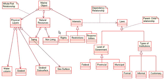
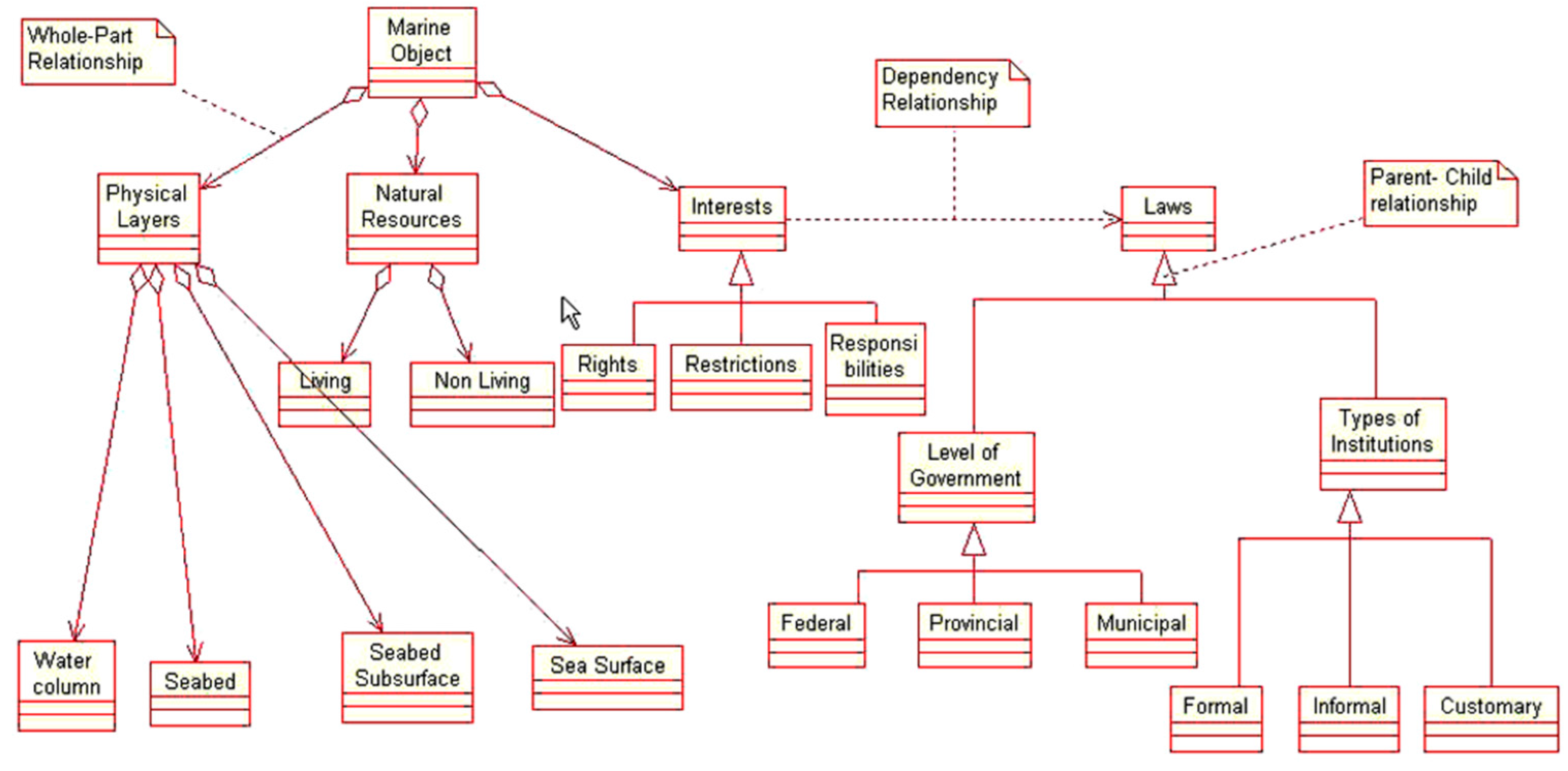
A Marine Rights data model is described by [12] (p. 463), as one “which provides a standard way to capture the laws that facilitate the allocation, delimitation, registration, valuation and adjudication of marine property rights; the interests that are allocated; the resources that the interests refer to; and their 3D spatial extent” (Figure 1). This model attempts to represent environmental, legal, and institutional elements that are generally associated with marine parcels. Their design is based on the fact that rights, responsibilities and restrictions in marine spaces relate to explicitly 3D/4D space i.e., to the sea surface, water column, seabed, and seabed subsurface. The design also incorporates the fact that rights, responsibilities and restrictions can be held by various types of stakeholders, in formal or informal ways. However, Ng’ang’a et al. [12] did not incorporate into their design any representation of stakeholders except government entities. The authors argue that there exists a marine parcel object as a base for data collection, storage, and retrieval on marine interests. This perspective was shared by Lemmen [19], who states, in relation to the LADM that “With some imagination, the laws (formal or informal) can be seen as parties; in fact, the laws allow people to have interests in “marine objects”. The interests are RRRs and the MarineObject corresponds with the SpatialUnit in LADM Version C. Thus, it is expected that LADM can be used to marine space.” The application of the LADM to the marine environment highlights the differences that may arise in the application of conceptual data models to different jurisdictions. The main issues refer to the decisions taken regarding how basic administrative units and any derivative spatial units are modeled. There are also differences relating to the linking or interfacing of land-based cadastres (that are based on existing standards) with newly defined standards applicable to marine spaces [14]. Another issue is the size of the marine parcel. The marine parcel shall not be of fixed size as human activity is greater closer to the coasts, e.g., ports, high density vessels traffic, seaplane landing areas, dumping ground, fisheries, and wind farms. Hence, the closer to the coast the smaller the marine parcel.
Figure 1.
A marine parcel data model [12].
A marine data model that is based, in part, on the LADM and marine cadastre concepts was presented by Canadian Hydrographic Service [20]. The authors propose the development of the S-121 IHO standard, “built upon the Object Oriented structure of S-100”, that would be able to handle MLB. The IHO S-121 product specification for MLB has now been published as a Draft International Standard and, in the future, can be a basis for combining data from different MASs.
3. Marine Cadastral Data Model and Standard Criteria
The obvious 3D nature of marine spaces requires that specific criteria be met when developing marine cadastre logical and physical models. A review of literature relevant to the development of MC data models (and by implication data standards applicable to MC and MAS) imply that the following ought to be considered when developing MC or MAS [15]:
- The recording, updating and termination of various and overlapping types of formal and informal RRRs that affect multiple purposes and objectives in various jurisdictions [12,21];
- Diverse groups, individuals, and entities to whose rights, restrictions, interests, and responsibilities are ascribed [12,22];
- Various and overlapping types of 3D formal and informal boundaries and limits that relate to sea surfaces, water columns, the seabed and the seabed subsoil, some of which can change in space and time due to [12,23,24,25,26];
- Transfers of, or changes in, rights, restrictions, interests, and responsibilities;
- The ambulatory nature of some marine related boundaries;
- Various types of metadata, and other spatial information and surveying/mapping elements, such as datum, projections, data acquisition methodologies, etc., that are attributable to defined 3D spatial extents [12,27];
- Various types of non-spatial information (e.g., ecological, political, social, economic, etc.), attributable to defined 3D spatial extents [12,28,29];
- Complex levels of overlapping government laws, legislations, regulations, policies, treaties, conventions etc., that affect behaviors in defined 3D marine spatial extents [12,28,29,30];
- Possible integration of the marine cadastre datasets with other datasets in a spatial data infrastructure [12,16,20,31,32];
- The recording, updating and termination of various and overlapping types of formal and informal RRRs that affect multiple purposes and objectives in various jurisdictions [12,21].
According to [15], the LADM can handle the foregoing requirements, and, therefore, it is applicable for use in relation to marine environments. S-121, being in part built upon LADM classes and relationships, seem to be able to meet the aforementioned requirements. LADM and S-121 are discussed in the following sections.
4. International Standards Relating to Marine Environment
Standards are widely used, since they provide efficiency and support in communication between organizations and countries, as well as for system development and data exchange based on common terminology. Domain specific standardization is required to capture the semantics of marine administration. Such a standard will support marine registry and cadastral organizations utilizing a Geographic Information System (GIS) along with a spatially enabled Data Base Management System and applications, in order to implement and support marine policy implementation.
Current discussions and efforts in administration of marine spaces focus on the development and implementation of marine data modeling taking into account practices from Land Administration Standardization. Therefore, the registration of interests encountered in marine environments, along with their spatial dimensions, may be modeled in in the same manner as those modeled with land-based standardization techniques [18].
The following sub-sections discuss international standards that can be applied to marine environments. These include LADM, S-100, S-121, and Infrastructure for Spatial Information in Europe (INSPIRE).
4.1. LADM
The LADM was approved on the 6 November 2012 as an international standard, as ISO 19152, constituting the first adopted international standard in the land administration domain [33]. LADM provides a formal language for the description of existing systems, based on their similarities and differences. It is a descriptive standard, not a prescriptive one and can be expanded. LADM is organized into three packages and one sub package [19]. These packages are groups of classes with certain levels of cohesion. The three packages are: Party Package; Administrative Package; Spatial Unit Package and subpackage: Surveying and Spatial Representation Subpackage. The model contains thematic and spatial attributes. Furthermore, in several attributes, code lists are used rather than character strings in order to ensure consistency. The modification and adoption of code lists in national profiles is possible.
From the 3D perspective, LADM supports both 2D (LA_BoundaryFaceString) and 3D objects (LA_BoundaryFace) and distinguishes legal and physical objects by introducing external classes for BuildingUnit and UtilityNetwork. It covers the legal space, but the physical counterparts are not directly generated in LADM. At the semantic level, legal entities are not enriched by classifying data in relation to each other [34]. Furthermore, LADM through the VersionedObject class provides the attributes beginLifespanVersion and endLifespanVersion, allowing the recreation of a dataset at a previous point in time, which leads to a 4D visualization of the Cadastre [14].
The implementation of the model in marine environments is a user requirement in LADM version A. Furthermore, the scope of the standard explicitly addresses water-covered land when referring to land. The common relationships that can be observed in land administration systems may also be modeled in the LADM through a package of party/person/organization data, RRR/legal/administrative data, and spatial unit (parcel) data. The same pattern is also applicable in marine spaces.
4.2. IHO S-100 Universal Hydrographic Model
The IHO is an intergovernmental consultative and technical organization that was established in 1921 to support safety of navigation and the protection of the marine environment. IHO S-100 provides a contemporary hydrographic geospatial data standard that can support a wide variety of hydrographic-related digital data sources. Unlike its predecessor (S-57), which was primarily developed to meet the Electronic Navigational Charts (ENC) requirement for International Maritime Organization (IMO) compliant Electronic Chart Display and Information Systems (ECDIS) and which eventually became synonymous with ENC production and exchange standard specification, S-100 is inherently more flexible and aims to cover all aspects of hydrographic and marine information. S-100 is fully aligned with mainstream international geospatial standards, in particular the ISO 19100 series of geographic standards, thereby enabling the easier integration of hydrographic data and applications into geospatial solutions.
The primary goal of S-100 is to support a greater variety of hydrographic-related digital data sources, products, and customers. This includes the use of imagery and gridded data, enhanced metadata specifications, unlimited encoding formats and a more flexible maintenance regime. This enables the development of new applications that go beyond the scope of traditional hydrography—e.g., high-density bathymetry, seafloor classification, marine GIS and MLB. S-100 is designed to be extensible so that future requirements, e.g., 3D, time-varying data (x, y, z, and time), and Web-based services for acquiring, processing, analysing, accessing, and presenting hydrographic data, may be easily incorporated [35].
4.3. IHO S-121 Maritime Limits and Boundaries
Following the adoption of S-100, a number of product specifications are under development by the IHO S-100 specialized Working Groups (WGs), including S-101 for ENCs and S-121 for MLB. The intended purpose of S-121 is “to provide a suitable format for the exchange of digital vector data pertaining to maritime boundaries” and “for lodging digital maritime boundary information with the United Nations for purposes related to United Nations Convention on Law of the Sea (UNCLOS)” [36] (p. 1). Furthermore, as all ISO 19000 series product specifications, S-100 and the subordinate S-121 are intended to interwork with all similar products. In that sense, S-121 may serve as the bridge between the land and marine domains while the MLB of the S-121 standard may be used in an MAS.
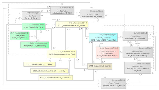
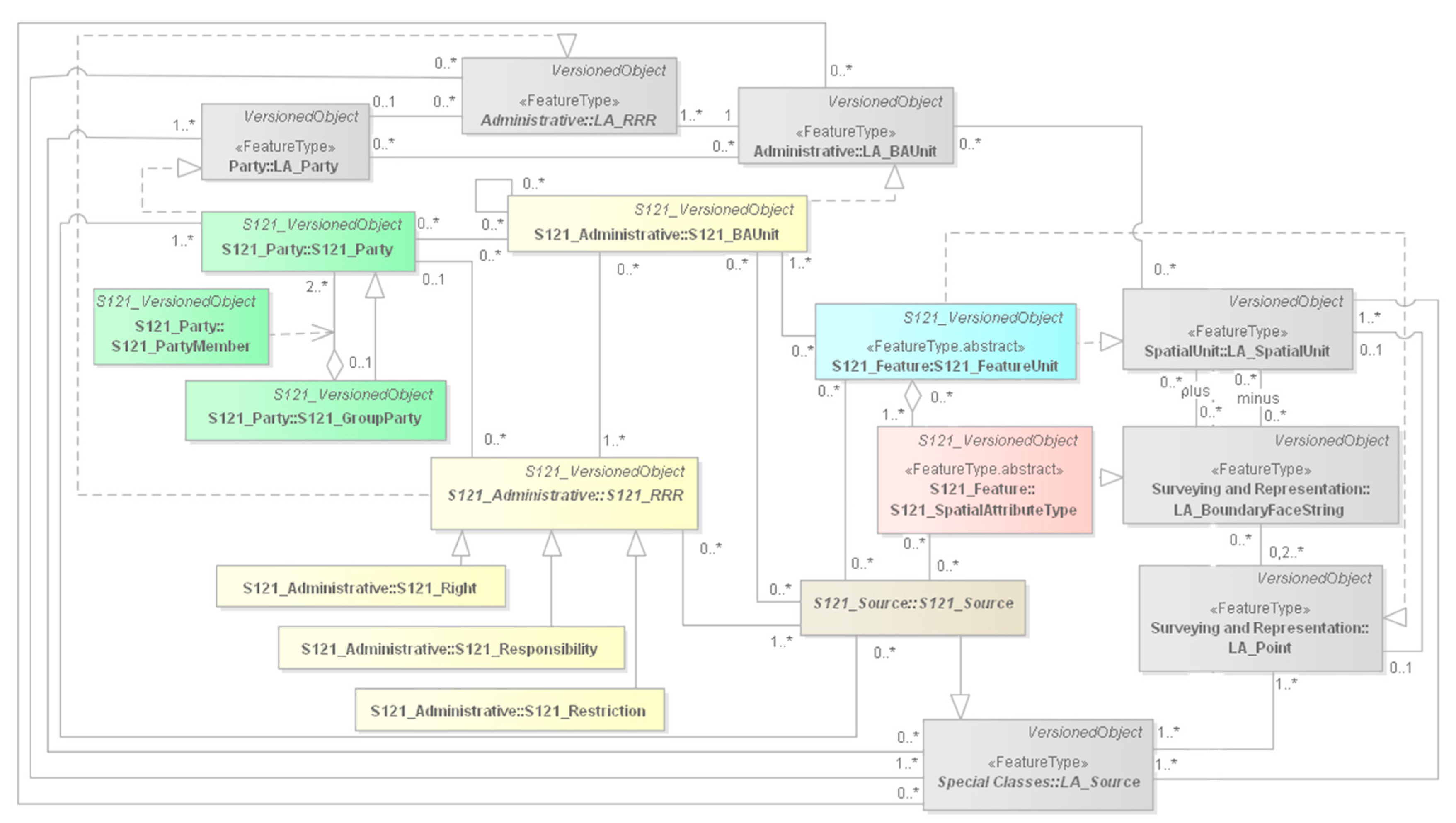
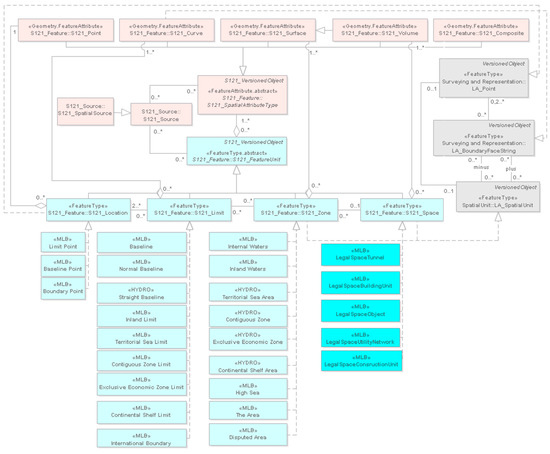
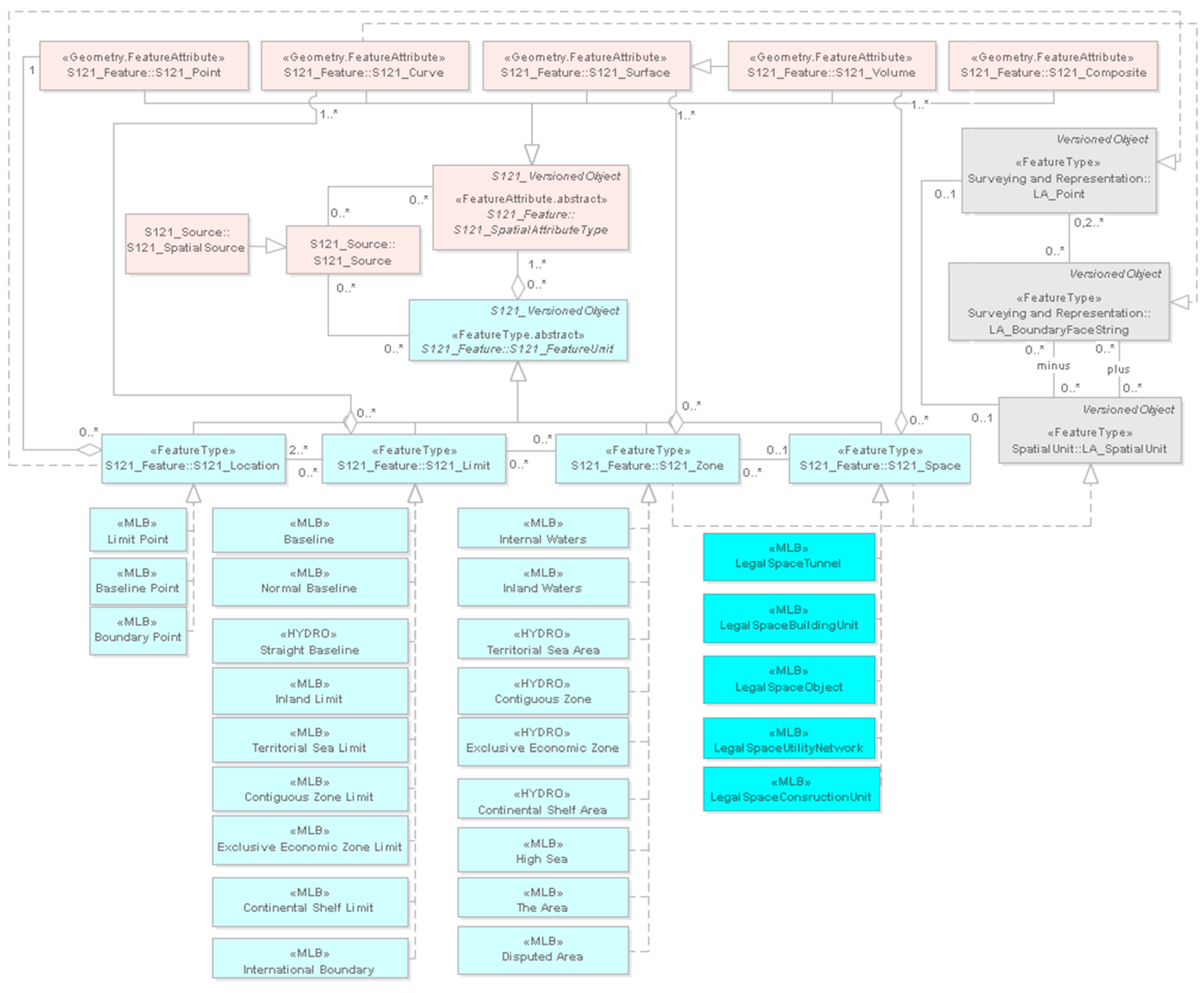
S-121 is built upon the ISO 19152, which provides a rigorous mechanism for handling legal RRRs. Although the title of LADM refers to “land”, the scope of LADM includes those elements “over water and land, […] above and below the surface of the earth” [33], which makes it applicable to the marine environment as well. LADM has much in common with the management of MLB, while it provides a foundation to extend S-121 into the management of other regulated boundaries, such as marine reserves and fisheries. The alignment with the land domain model will facilitate consistent administration across the land and maritime domains for those states that adopt S-121 for use in relation to their marine spaces and ISO 19152 for use in relation to their exposed land jurisdictions [18]. Figure 2 illustrates the classes of S-121 that relate to ISO 19152 classes with realization relationships. Figure 2 illustrates the classes of S-121 that relate to ISO 19152 classes with realization relationships. Firstly, using this kind of relationship, any of the ISO classes could be introduced into the S-121 model if they are needed and secondly only the necessary attributes can be inherited from ISO 19152 to S-121 model.
Figure 2.
S-121 classes related to LADM.
A dataset of MLB consists of the entities pertaining to UNCLOS, i.e., Baselines, Zones, Limits, and Boundaries. More precisely, S-121 includes Shoreline and Coastline, Internal Waters, Archipelagic Waters, Territorial Sea, Contiguous Zone, Exclusive Economic Zone, Continental Shelf and International Boundaries. However, entities the states may declare (e.g., joint development areas) due national law or bilateral treaties are not included, and, therefore, for their use in a Marine Cadastre system, they need to be defined. In S-121, each real world feature is an object with properties represented as attributes (spatial and thematic) and associations which establish context for the feature. The four major components of each MLB object are [18]:
- (1)
- the party component which defines the different actors and their role associated with an object;
- (2)
- the geospatial component which defines the location and type of the object;
- (3)
- the legal component, which supports the description of the associated jurisdictions, and rights, associated with objects;
- (4)
- the administrative or spatial sources such as treaties, legal documents, charts.
The spatial attributes of the feature describe its geometric representation, whereas the thematic attributes describe its nature. The attributes associated with the geographic feature depend on the intrinsic type of the feature. A feature object may only have one intrinsic type that is the physical dimension of the feature in the real world based on the “truth on the ground” principle, i.e., point, curve, area, and volume. Subsequently, the feature is described in the dataset by a geometry property (point, curve, area-volume is area with elevation attribution), which is used for its cartographic representation that depends on the scale of the cartographic product. Finally, for the portrayal of each geometry property, which is separate from geometric representation, a variety of symbols may be used. For instance, the intrinsic type of an aquaculture installation is Zone. Depending on the scale of the cartographic product, the geometry of the farm may be area (large scale maps) or point (small scale maps). Finally, for the portrayal of, e.g., the point geometry, can be used a simple point, a star or a variety of other symbols. In S-121, portrayal is in compliance with the S-100 standards, whereas, for specific objects unique to MLBs, the use of new symbology may be required [18].
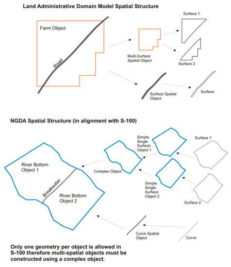
S-121 imports various primitives from LADM that are useful for an MLB standard and not supported by S-100, e.g., GM_Curve and GM_Surface from the ISO 19152 class LA_SpatialUnit. S-121 has also versioning capabilities for all objects within the model, meaning a historical tracking of the object’s evolution. Versioning is another attribute that consists of begin and end dates, allowing attributes and features to be changed at the individual level, e.g., changing the right to a fishing zone among seasons. The Versioned Objects structure is clearly valuable in the MLB and MC application areas and also appropriate in an MSDI [18]. A fundamental difference between the LADM and the S-121 is the use of the Multi-primitive MultiSurface features in the land environment, whereas, in the marine environment, it is a requirement from S-100 to use complex features instead. In detail, when an object is crossed by another, in land, the crossed feature is defined as a multi-surface, whereas, in the marine environment, each spatial primitive is a simple rather than a complex one (Figure 3). Another issue is the use of 3D objects, which LADM addresses with the LA_BoundaryFace and LA_BoundaryString, whereas, due to the limitations of S-100, which does not address 3D objects, S-121 handles 3D objects as 2D objects with vertical extent (2.5 dimensions) [20].
Figure 3.
Terrestrial and maritime spatial structures according to LADM and S-100 [18].
4.4. INSPIRE
For cross-border access of geo-data, a European metadata profile based on ISO standards has been developed using rules of the implementation defined by the Infrastructure for Spatial Information in the European Community—INSPIRE [33]. INSPIRE (Directive 2007/2/EC) focuses strongly on environmental issues, while the LADM has a multipurpose character. One important difference is that INSPIRE does not include RRRs in the definition of cadastral parcels.
From the spatial perspective, according to [33], there is a compatibility between LADM and INSPIRE. More specifically, four classes are relevant in the INSPIRE context:
- LA_SpatialUnit (with LA_Parcel as alias) as basis for CadastralParcel;
- LA_BAUnit as basis for BasicPropertyUnit;
- LA_BoundaryFaceString as basis for CadastralBoundary; and
- LA_SpatialUnitGroup as basis for CadastralZoning.
Regarding the marine space, the expression and the definition of the above classes need to be examined.
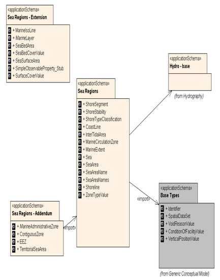
INSPIRE data specifications are being developed across 34 themes. Many INSPIRE themes have a marine relevance, something that researchers have already pointed out (e.g., [37]). The marine related themes are presented in Figure 4. Two of the themes, i.e., Ocean Geographic Features (OF) and Sea Regions (SR), are related exclusively to the marine environment. According to [38], “INSPIRE is not marine nor land centric”. Themes are considered independent of whether or not they refer to land or to sea, and therefore data can be brought together across land-sea boundaries. INSPIRE provides a level of interoperability to deliver integrated land-sea datasets. However, the data models (by design) will not solve the needs of all communities e.g., navigation. The marine themes on their own do not give all the information on the marine environment.
Figure 4.
Marine related classes of INSPIRE [38].
According to [19] (p. 169), “firstly, it is possible that a European country may be compliant both with INSPIRE and with LADM and secondly, it is made possible through the use of LADM to extend INSPIRE specifications in future, if there are requirements and consensus to do so”. Given that IHO S-121 Product Specification for MLB is based on LADM, it is inferred that INSPIRE can cooperate as well with S-121 mainly in the spatial dimension.
5. IHO S-121 Maritime Limits and Boundaries and Marine Legal Objects
For the development of an MAS, the association of legal attributes with MLB information or marine parcels is necessary, in order to determine under whose authority or international treaty a particular limit or boundary is defined, and the restrictions around this specific marine parcel according to the legislation.
From an administrative modeling viewpoint where the focus is on abstracting the real world as a principle, sea is not a legal entity until an interest is attached to it. Therefore, the very close relationship between each interest and its spatial dimension in the real world should be identified and registered in information systems. These elements form a unique entity: the marine legal object.
Cadastres deal with entities consisting of interests on land that have three main components: spatial (spatial units), legal documents, and parties [34]. The same applies in the marine environment.
The S-121 Product Specification developed in order to support additional types of data that may be compatible with the eNavigation information, but they are not included in S-100 Universal Hydrographic Model. The theme behind these additional types of marine data is legal rights. Experience in this area does not derive from marine navigation, but it is largely based on the methods by which these legal rights issues are addressed in terrestrial mapping [18]. Therefore, the introduction of Parties, Legal Interests and Administrative Units is derived from ISO 19152. Since the LADM and IHO S-100 are both built on the ISO TC211 suite for Geographic Information standards, the elements of spatial units, spatial sources, spatial representations, basic administrative units and administrative sources are compatible and can be inherited into IHO S121. Appendix E of S-121 Product Specification describes how the LADM related classes are integrated into S-121.
The ISO suite of geographic information standards and the derivative IHO S-100 Universal Hydrographic Data Model are built upon an object structure [18]. The objects have two kinds of properties, spatial and thematic attributes. The IHO S-100 has added to the ISO General Feature Model the Feature Types (i.e., objects with existence in the real world) and Information Types (i.e., objects with no real geographic spatial position, only with thematic attributes). The whole structure of S-121 is built upon these objects.
Review of S-121 and adaptation of certain attributes and classes that are proposed by [1] are described below. The workflow of this research includes the identification of the unique characteristics of marine environment, the review of the marine related data models and finally the extension of the existing terrestrial methods and standards, through the enhancement of S-121 in order to address the special marine needs.
5.1. S-121 Party Unit Package
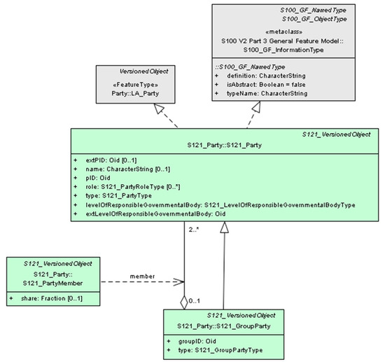
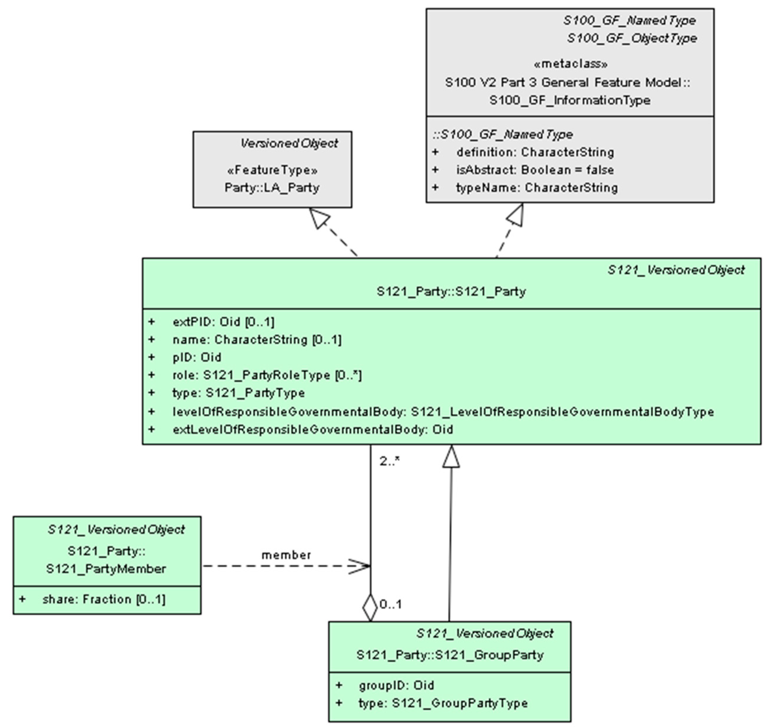
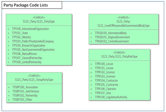
S-121 inherits the structure of ISO 19152 for the party package. The basic class is the S121_Party, which has a specialization of the S121_GroupParty. Between S121_Party and S121_GroupParty, there is an optional association class the S121_PartyMember (Figure 5). There is an aggregation relationship between S121_Party and S121_GroupParty, which means that an individual may be a member of a group, and a group as a whole can be treated as a party [18].
Figure 5.
S-121 Party package ([18], p. 57, edited by the authors).
In a marine environment, the party can be a stakeholder or most likely a group of individuals or companies. The party can also be the state. According to [1,16], the additional attribute of the levelOfResponsibleGovernmentalBody will be useful in the marine environment. It specifies who has the supervisory control to exercise a RRR according to the relative law and its registration could be mandatory. Furthermore, the values of attribute “role” can be originated from a code list, instead of using character strings, as long as the roles are specific in the data update and maintenance processes. S-121 Party Unit package with the aforementioned additions in class S121_Party is presented in Figure 5.
5.2. S-121 Administrative Package
The operation of a Land Administration System (LAS) is based on the relationships between parties (stakeholders) and property units. Property is conceptualized as consisting of the rights, objects, and subjects. The suggestion of [39] is that property with its emphasis on ‘rights’ is a subset of land tenure, which is a much broader term with emphasis on RRRs. In the marine environment, property describes the resource, individual/s with an enforceable claim, and type of resource use claims [40]. Moreover, other than the state owned parcels in the territorial sea, parcel boundaries are determined according to usage only (e.g., minerals, aquaculture) and not as a property. There is not usually a market in ocean parcels where parcels are subdivided and consolidated and sold off, nor is the system designed to support this [41]. Therefore, in oceans, a different legal regime is shaped. The following types of RRRs can be found [17]:
- State Interests: The state RRRs are defined through the international Treaties (and bilateral agreements for states with maritime neighbors) and transposed into national legislation with laws. When referring to sovereign rights, we mean the power of the state and/or the sovereign entity (as regards the marine space, the sovereign entity is always the coastal state) to act as they deem appropriate for the benefit of their citizens. The legal term of the aforementioned power is "exclusivity of jurisdiction" that according to the international law implies that the state has complete control of its affairs within its territory, without being accountable for the means of exercising this control. The extent or the kind of the sovereign rights differ, according to the specific zone of the marine space it refers to. The full sovereignty or the sovereign rights of the coastal state means that, apart from the coastal state, private entities (natural or legal persons) can exercise an activity or use part of the marine space only by means of transferring of a right from the State for a specific activity under contract or licensing. This kind of rights are recorded by an MAS. Table 1 summarizes the rights of states in marine space as they are defined in UNCLOS, which may then be transferred to the private entities.
- Public Rights: Public rights refer mainly to the constitutional right of every citizen of the state having an unlimited/ without obstacles access statewide (terrestrial and marine space). These rights are not secured for an individual interest but for a public interest (e.g., public right to beach access). They may be described as protecting the public interest in the use and conservation of resources.
- Environmental RRRs: Refer to provisions that relate to the protection and conservation of water resources, places of preserved areas and cultural heritage. These places are pre-defined by law and the rights involved are of utmost importance and mandatory, in comparison to the following functional interests [1]. These RRRs include amongst others, the protection of archaeological and historical objects found at sea, the protection of Marine Protected Areas and the general MSP restrictions.
- Usage and Exploitation Rights: Progressively functional rights tend to acquire a private nature, associated with individual stakeholders that coexist with the state rights. In a wide sense, this term sets the limits of rights, which involve mainly the different ways of use and management. In other words, in the marine environment, the rights are limited in terms of space, duration and most importantly the extent, the content that refers only to the different kind of uses and management. The stakeholders are not owners but only beneficial “users” [1]. When private property rights are used as a basis of interpretation, these rights do not represent full ownership let alone absolute property rights; they can be classified into usage and exploitation rights. Usage rights are associated only with space, and exploitation rights are associated with the resources as well. Usage rights may be granted by a legal person that has been delegated the authority to provide usage rights. Rights granted in this manner are subject to restrictions in terms of the nature of the usage rights (e.g., type and temporal aspects of use) and the spatial extent linked to the usage rights (sometimes defined by boundaries). Functional rights are granted either by leasing contracts or through licensing. It has to be noted that the authority of granting remains national and no freehold ownership is involved. These rights are associated with specific stakeholders.
Table 1.
Rights of states within maritime zones.
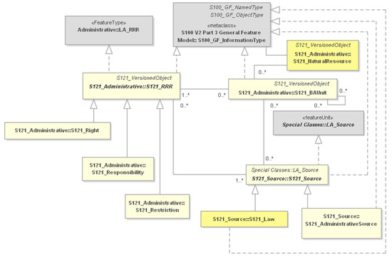
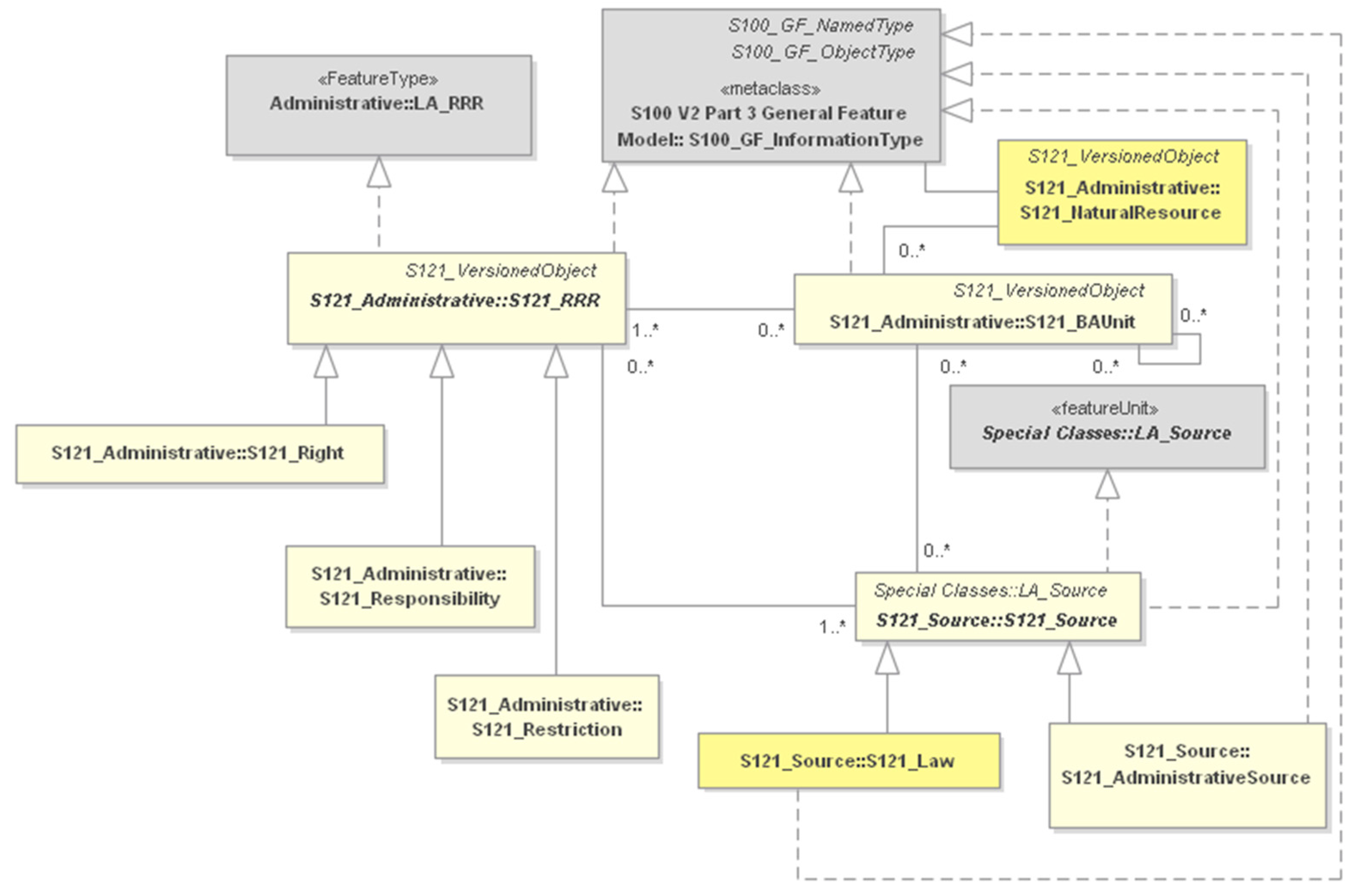
ISO 19152 defines an administrative package that associates parties with the Basic Administrative Unit. The same relationship applies in S-121. The S121_BAUnit is derived from the class LA_BAUnit and the definition remains the same. RRRs appear as attributes for an S121_BAUnit [18] and are subtypes of the abstract class S121_RRR. The class LA_Mortgage is not expressed in the model, since it is not normally applicable in the marine environment and as long as realization relationships are used between S121_RRR and LA_RRR classes. Therefore, any of the ISO classes could be included or excluded into the S-121 model. RRRs are implemented as information objects, and, accordingly, the RRRs can be shared.
In addition, there is one important aspect that is missing in S-121, the marine resources. When defining a RRR in marine space and the S121_BAUnit this RRR refers to, the registration of the natural resource that falls within its spatial extend is needed in an MAS, and could be occurred through the class S121_NaturalResource. The proposed attributes for this class are: the resourceID, the description, living (Boolean), resourceType and renewableType. The values of the last two attributes may be derived from predefined codelists. S-121 Administrative Unit package with the aforementioned additions is presented in Figure 6.
Figure 6.
S-121 Administrative package ([18], p. 59, edited).
5.3. S-121 Spatial Unit Package
A plethora of research works and papers in literature deal with the definition of the marine parcel. Two alternative hypotheses are given by [12] about the marine parcel: “(1) that there either exists a multidimensional marine parcel that can be used as the basic reference unit in a MC, or (2) that there exists a series of (special purpose) marine parcels that can be used as basic reference units for gathering, storing and disseminating information. In either case, then, whereas the definition and spatial extent of a parcel is still not clarified, there still exists a parcel.”
Another definition of marine parcel refers to: “A confined space having common specifications for its internal, mainly used as reference to locate a phenomenon. A marine parcel facilitates the distinction between contiguous territories and provides information concerning this phenomenon through appropriate codification” [3].
For the definition of the marine parcel, certain issues must be taken into account:
- The third dimension: The inherent volumetric 3D nature of marine space is apparent. Marine RRRs, such as aquaculture, mining, fishing, and mooring and even navigation, can coexist in the same latitude and longitude but in different depths. The question is if the 3D representation is necessary for an MAS. So far, the geomatics’ community supports the idea of the 3D registration and visualization of marine interests. According to [12] (p. 446) “…Clearly, the right to explore for minerals may have an impact on the surface of the land, but it will also affect a 3D cross-section of the parcel below the land’s surface. Policy-makers would no doubt benefit from an understanding of the upper and lower bounds of the exploration rights, and how these may affect the environment or other property entitlements within the same parcel.” Additionally, the registration of the restrictions that are defined by the laws and structure the marine legal object are related with the third dimension for most activities. They define in which vertical or horizontal distance is allowed to exercise other marine interests. Furthermore the multipurpose nature of the MAS demands access to additional types of information (geology, hydrology etc.), additional types information (geology, hydrology etc.), except of the RRRs, in relation to marine spatial extents. The use of the third dimension is considered important. However, the existing MAS have only used the third dimension for the representation of the seafloor.
- The fourth dimension: It is clear that time has always played an important role as the fourth dimension in cadastral systems. In the marine environment, most activities can co-exist in time and space and can move over time and space. Therefore, the registration of the fourth dimension will capture the temporary nature of many particular rights.
- Spatial Identifiers: Every land parcel or property recorded in a land registry or a cadastral information system must have an identifier. In fact, identifiers are the most important linking data elements in land administration databases. There are various ways for referencing land parcels and property [42]. In the Hellenic (Land) Cadastre for each individual property, a 12-digit code number is assigned, the “KAEK” , which is unique nationwide. It is proposed by Arvanitis et al., the use of a unique code to the marine parcels. “The 12-unit code will be based on the legislated zone, the Sea, the Greek Prefecture, the Head Office of the Port Authority Jurisdiction/Municipality, the use and number of the marine parcel”. The code will be unique and will record the existence of multiple uses in the third dimension [17].
The Spatial Unit as defined in S121 is derived from the class LA_SpatialUnit defined in ISO 19152, but it also inherits from S121_GF_SpatialAttributeType [18]. However, the ISO 19152 has a very different structure for its Spatial Unit Package and Surveying and Representation SubPackage, since it is land oriented.
The S121_SpatialAttributeType describes the spatial properties of an S121_FeatureUnit. The subtypes of the S121_SpatialAttributeType are the S121_Point, S121_Curve, S121_Surface, S121_Volume and S121_Composite. The geometry types are inherited from S-100. Additionally, there are four feature types: Location, Limit, Zone and Space, which are connected with realization relationships to predefined feature types, named MLB Feature Types. However there are subtypes only for the Location, Limit, Zone ([18], Appendix F). According to IHO S-121 [18], there are no MLB Space objects defined. Any Space object needs to be generated from the generic object Space and registered in the Feature Catalogue for a particular product. It is proposed that Space Objects can be further specialized to LegalSpaceTunnel, LegalSpaceUtilityNetwork, LegalSpaceObject and LegalSpaceConsructionUnit, which can be externally linked to their physical counterparts using extID within these classes. In this way, the integration of physical and legal objects by virtue of international standard models is attained, as it occurs through the use of LA_LegalSpaceBuildingUnit and LA_LegalSpaceUtilityNetwork in ISO 19152. S-121 Spatial Unit package with the aforementioned additions is presented in Figure 7.
Figure 7.
S-121 Spatial Unit package ([18], p. 68, edited).
Spatial Dimension and Associated Issues
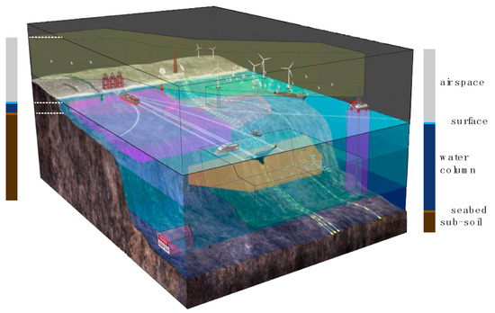
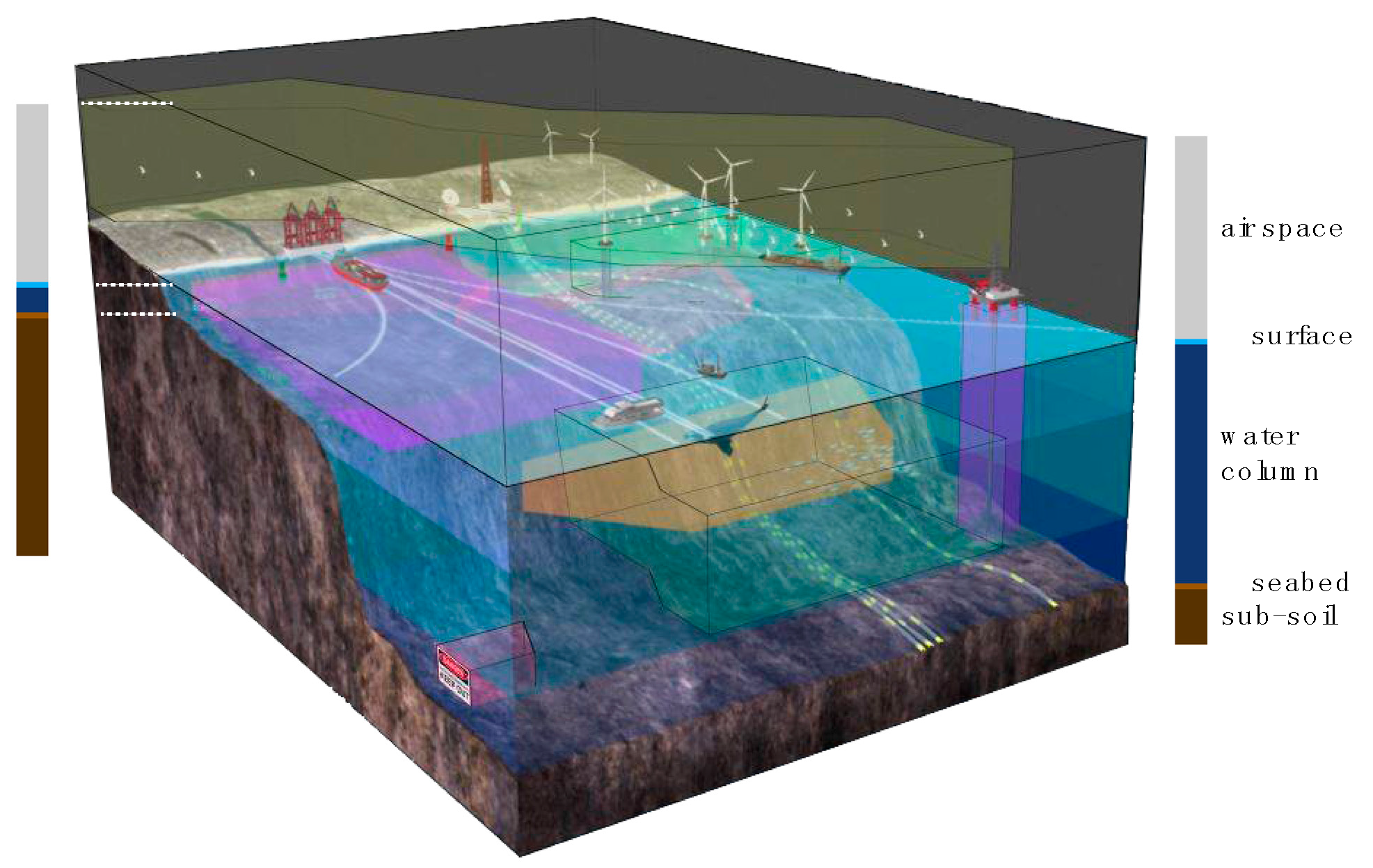
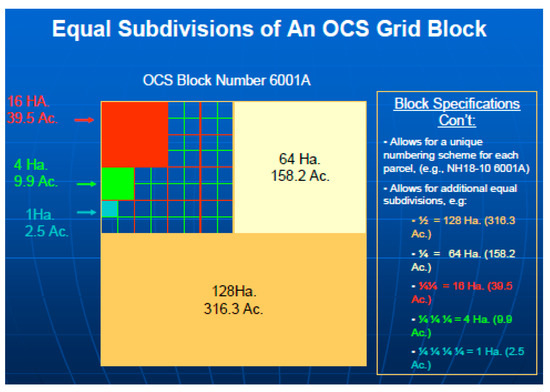
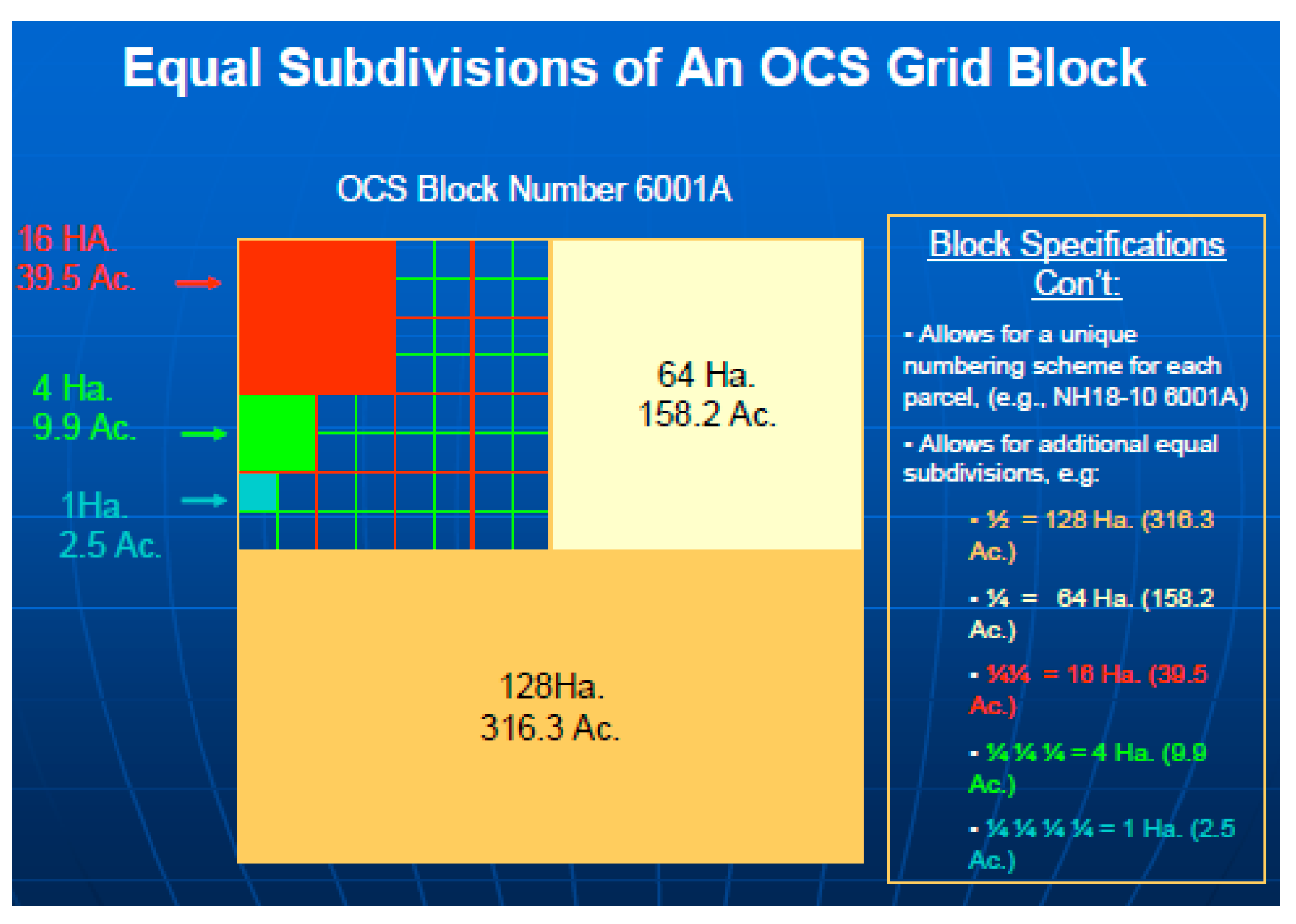
The basic reference unit, could be spatially defined as: a multidimensional marine parcel or a series of (special purpose) volumetric marine parcels [12] or as sea surface objects, water volume objects, seabed objects, and sub seabed objects [43], as shown in Figure 8, or as a single part of marine space deriving from the determined and standard division of the maritime surface using a grid of specific dimensions and subdivisions if needed, as shown in Figure 9. It is specified by geodetic coordinates of the surrounding boundaries. This method is already in use for defining the blocks in the domain of minerals exploitation. The combination of these methods is feasible [1].
Figure 8.
3D nature of marine parcel ([44], edited).
Figure 9.
Grid System for oil and gas exploitation in USA [45].
The selection of the geodetic datum, on which the coordinates will be referred, is one of the issues that should be taken into account in the development of a MC. A geodetic datum specifies the reference ellipsoid and the point of origin from which the coordinates are derived. Different states, even different mapping authorities of the same state, use different geodetic datums.
Consequently, coordinates derived from one system do not agree with the coordinates from another datum, with their differences between adjacent states, as [46] points out, amounting to several hundred meters. In addition to the horizontal datums, the utilization of different vertical datums has a significant impact as well. Hydrographic Services, which are assigned with the task to map the marine environment, as their priority is the safety of navigation they depict depth soundings from a mean low water level, such as the Lowest Astronomical Tide (LAT), or the more conservative Lowest Low Water (LLW). On the other hand, the Land cadastral services usually use the Mean Sea Level (MSL). The difference between the two, needs to be precisely calculated. One of the factors affecting the calculation is the distance of the permanent tide gauges from the location. The different sea levels and the precise calculation of the sea level have also a significant impact to the development of a MC. More specifically, the delineation of the coastline may vary greatly depending on the vertical datum, which consequently has a significant impact on the outer limits of the maritime zones over which the states exercise their rights. For instance, as Leahy et al. [47] describes, for a foreshore of 0.5% gradient, a difference of 0.5 m in sea water level results 100 m error in the location of the coastline, a value that may exceed 200 m in some cases. In extreme cases and depending on the techniques followed for the delineation of the coastline (e.g., digitization from small scale charts), Leahy et al. [47] calculated that the horizontal displacement of the coastline may reach 3 NM when (the coastline) has been derived from topographic maps of scales 1:100,000.
In addition, here comes another issue: where does the data come from? Is it data acquired in situ using techniques according to specifications, or data derived from paper charts/maps compiled years ago with obsolete and error prone techniques? Another issue with the different sea levels is the potential reclassification of a sub-surface feature to a low-tide elevation, which may expand the maritime zones of the coastal state [36] (Article 13(1)).
The precise delineation of the baselines is one of the most important issues [17] as they are the reference to measure the maritime zones. However, it is not the only issue that affects the precise division of marine space. As nicely put by Carrera [48], “marine boundaries are delimited, not demarcated, and generally there is no physical evidence, only mathematical evidence left behind”, hence the reference surface used for the delimitation of the outer limits and boundaries is another source of error. While technical publications, e.g., TALOS, state their preference towards the ellipsoidal earth, something of the kind is not stated in UNCLOS. The maximum relative error with approximating the earth as a sphere is 0.5%, but if projected plane was to be used for creating buffers of the baselines (e.g., Mercator projection) the produced error would be significantly greater.
Unfortunately, UNCLOS remains silent in many of its provisions regarding the technical aspects of the delimitation, including the horizontal and vertical datums, which the states need to consider and agree with neighboring states towards an effective MC.
5.4. S-121 Sources
The MLB data is primarily acquired from multiple external and internal sources, which can be registered in the model in the same way as in the ISO 19152. There are two subtypes of source S121_SpatialSource and S121_AdministrativeSource, which inherit the attributes from the abstract class S121_Source. The fact that all different rights find their base in some kind of transacting document is represented by the association between S121_RRR and S121_AdministrativeSource and this transacting document is recorded in the latter class. However, in marine environments, the existence of rights may be not created through the transaction, but from the implementation of law.
Therefore, two kinds of legal documents define the marine legal object [17]:
- Laws: The legislation which defines all RRRs of the marine space and constitutes the basis upon which the content of the administrative resources is developed. The term "law" leads to the main division between substantial and typical law (e.g., the legislation produced by the legislative power of the House of Representatives). Thus, the substantial law includes the principles of Common Law and equity, the administrative acts of the Administrative Authorities (Ministerial and Presidential Acts) as well as acts of legislative content. Needless to say, the European Law (Treaties, Regulations, Directives, Decisions) and the International law are main legal binding sources.
- Administrative Sources: The legal sources which include the administrative regime of the RRRs are defined. The administrative sources are: the legal contracts that relate to the disposal of the functional rights of the state to private entities (as defined by the legal framework). The functional rights of the state granted are either by means of an administrative contract (administrative long leases or public works contracts) or the right is conferred by an administrative act, most usually by a license agreement. The administrative sources that need to be recorded in an MAS are different depending on each activity. For several resources, the processes relating to registration of issue are standard. For example, in Greece, the registration associated with exploration for and extraction of gas and petroleum is highly refined. It is of high importance that all the activities that take place in the marine space need to be recorded accurately. This systematic recording could help to identify: the multiple licenses required for specific activities, regulated access rights, existing legal gaps.
5.5. External Classes
ISO 19152 provides stereotype classes for external datasets, which indicate what dataset elements the LADM expects from these external sources, if available. However, these datasets are outside the scope of LADM. They do not have the ‘LA_’ prefix, but they do give an exact definition of what the LADM is expecting of these external classes [33].
The product specification for MLB data provides attributes for the connection with external databases only for the Party Package and the Sources. More specifically: the exPID in S121_Party class, as an identifier of the party in an external registration and the extArchiveID in S121_Source class, as the metadata about an external archive. The use of the following classes is suggested in the proposed specializations of MLB Space Object: extPhysicalSpaceObject and extPhysicalSpaceUtilityNetwork, extPhysicalSpaceTunnel, and extPhysicalSpaceConstructionUnit.
Current considerations focus on the incorporation of 3D legal and physical objects. It is critical for data integration on legal spaces and on physical features to occur also in the marine environments, since the coincidence of boundaries of legal and physical spaces is very rare, if ever existent. Taking as reference the underwater tunnels, pipelines, utility networks, submerged archaeological cities or even underwater luxury hotels and facilities. Integration enables the reuse of geometrical data in different domains and the definition of legal spaces based on physical constructions [42].
Marine physical objects can be modelled by using appropriate 3D modeling techniques, constituting an area of research interest towards the development of an integrated land-marine administration system.
6. Code Lists of S121 Attributes Inherited from LADM for Greece and Trinidad and Tobago
Code lists are used to describe a more open and flexible enumeration. Code lists are useful for expressing a long list of potential values, aiming to allow the use of local, regional and/or national terminology [19].
Why use code lists instead of character strings? Code lists are used, rather than character strings in order to ensure consistency. Code lists of draft version of S-121 are currently generic and their content needs to be defined as part of the S-121 project development [18].
Therefore, implementation of the S-121 at a country level requires the modification of code lists to meet specific needs, since the values differ between the various legislation systems. In reference to the values of code lists provided by [18] and belong to the LADM related classes, those that are inherited from ISO 19152 are the following:
- S-121 Spatial Unit Package: LA_AreaValue, LA_AreaType, LA_SurfaceRelationType, LA_InterpolationType, LA_Transformation;
- S-121 Sources: LA_AvailabilityStatusType, DQ_EvaluationMethodTypeCode, Cl_OnlineFunctionCode, Cl_PresentationFormCode, Cl_RoleCode.
However, there are code lists inherited from ISO 19152, but different values are given in order to meet the marine environment special needs. These values can be further expanded to address each country’s national jurisdiction.
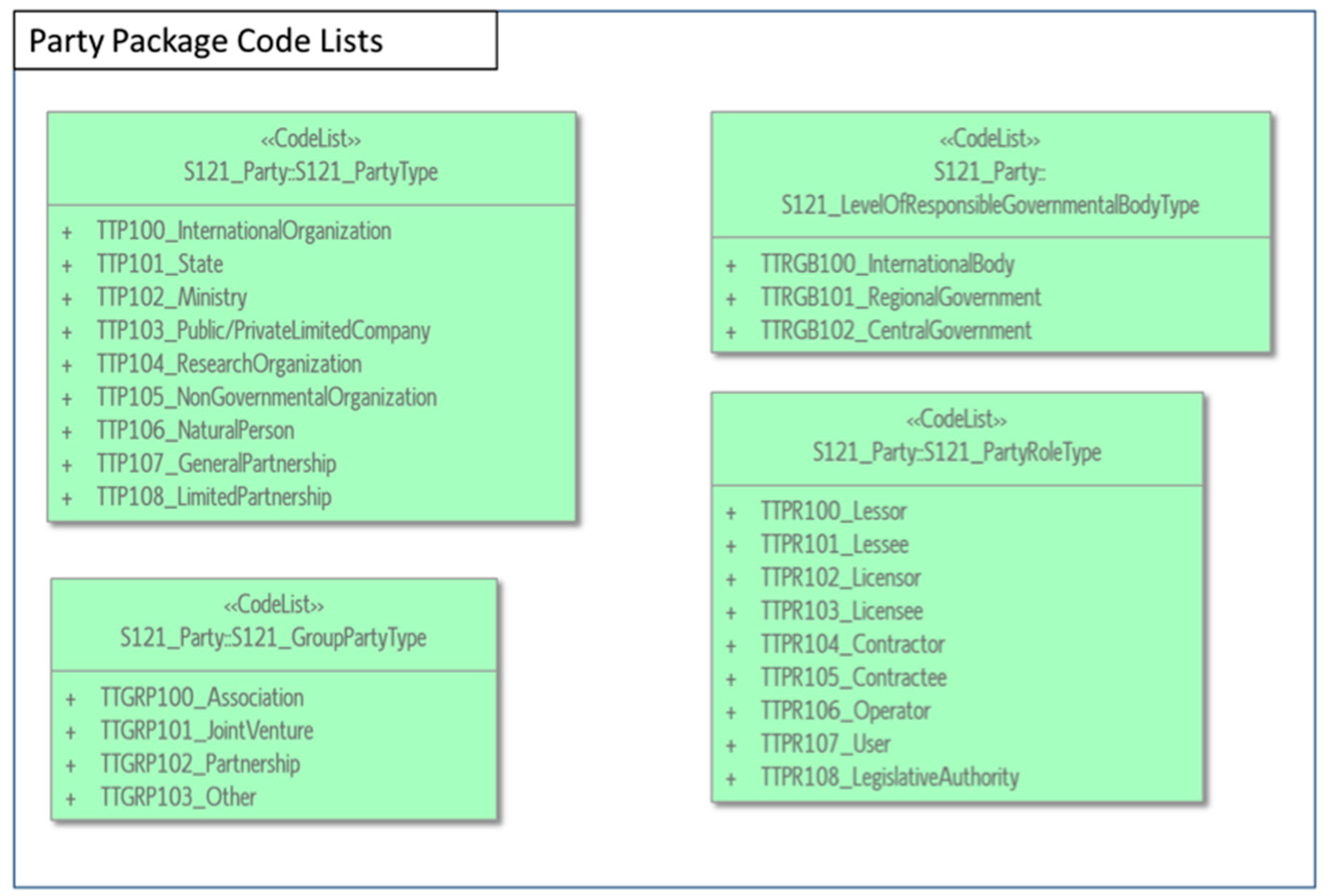
In the following subsections, values of the code lists for the LADM related classes for Greece and Trinidad and Tobago are proposed, which either differ from the predefined values of S-121 or are not defined at all.
6.1. Code Lists for Greece
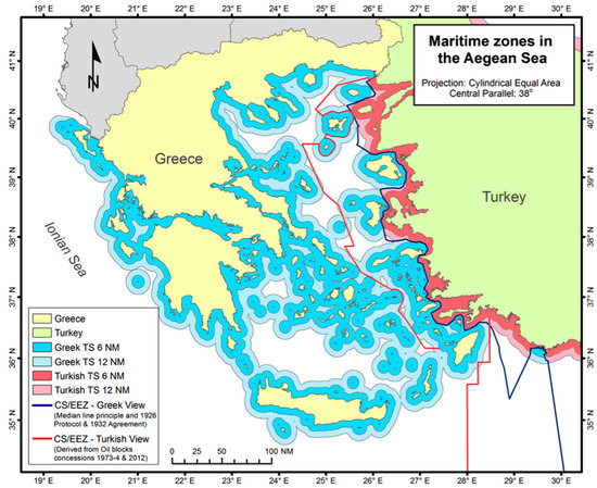
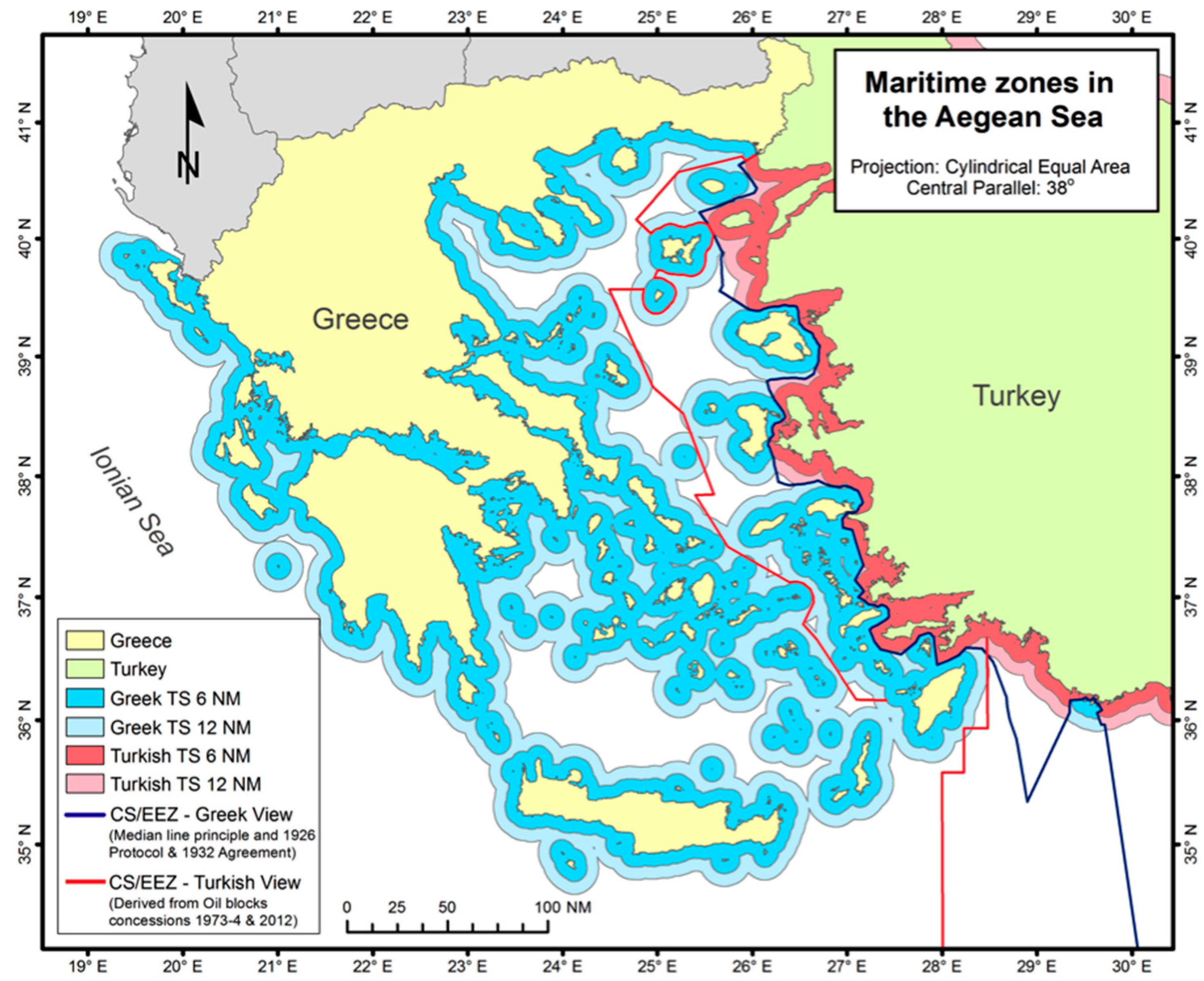
Greece is a state virtually surrounded by sea located in the Eastern part of the Mediterranean sea. Concerning the international law, Greece ratified the 1982 Convention on 21 July 1995 (Law 2321/1995) and since then has enacted a number of laws for the areas where sovereign rights are exercised (Figure 10). However, there is no comprehensive strategy to deal with the fractured and incomplete sets of data that are the legacy of the complex administrative and legal structures. A wide range of the existing marine RRRs is managed by the different governmental agencies. Figure 10 presents Greece’s territorial sea and the potential Exclusive Economic Zone (EEZ), Continental Shelf.
Figure 10.
Greece’s territorial sea and potential Exclusive Economic Zone (EEZ), Continental Shelf in the Aegean Sea [49].
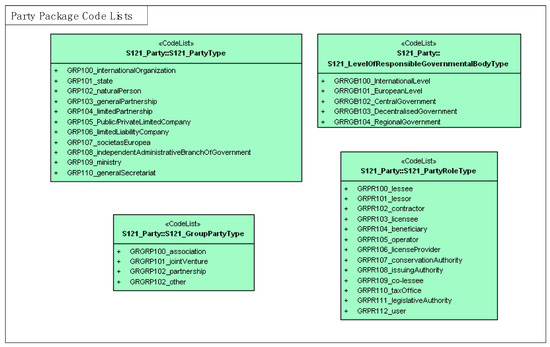
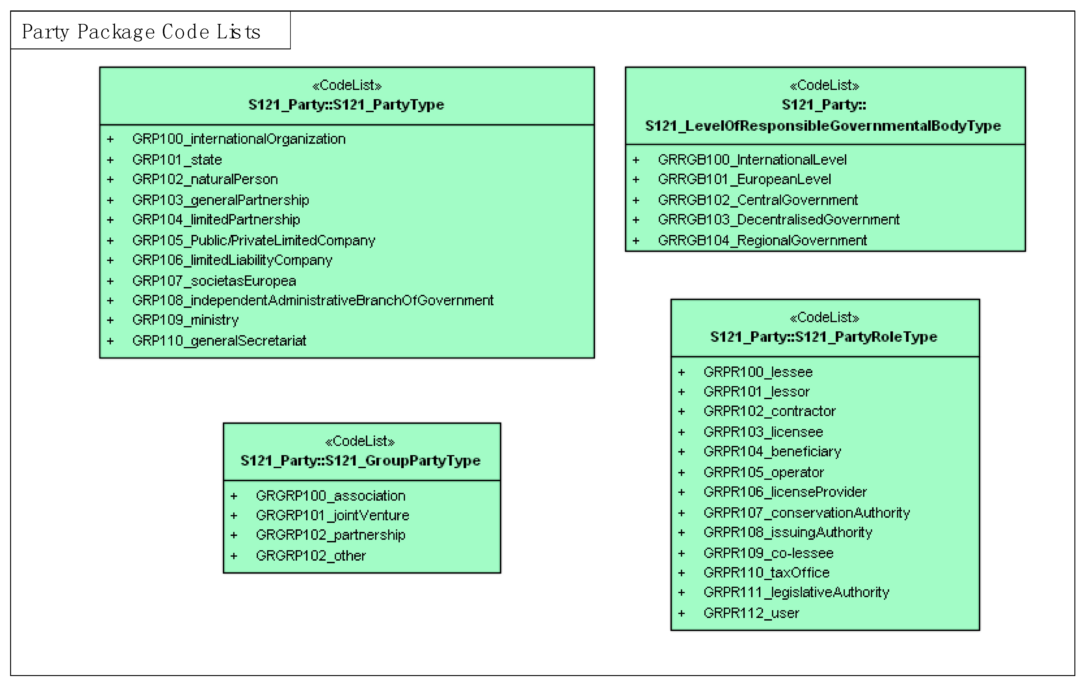
The development and implementation of an MAS, based on the S-121 standard, seems to be applicable to the management of Greece’s marine RRRs. In this section, the code lists relevant to the Greek case are presented (Figure 11), as derived from the current legal regime.
Figure 11.
Code Lists for S121 Party, S121 Administrative, S121 Spatial Packages and Source Classes for Greece.
6.2. Code Lists for Trinidad and Tobago
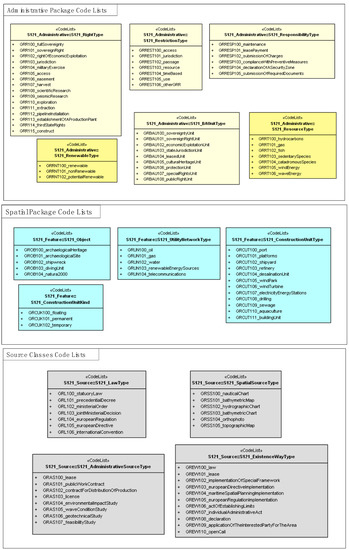
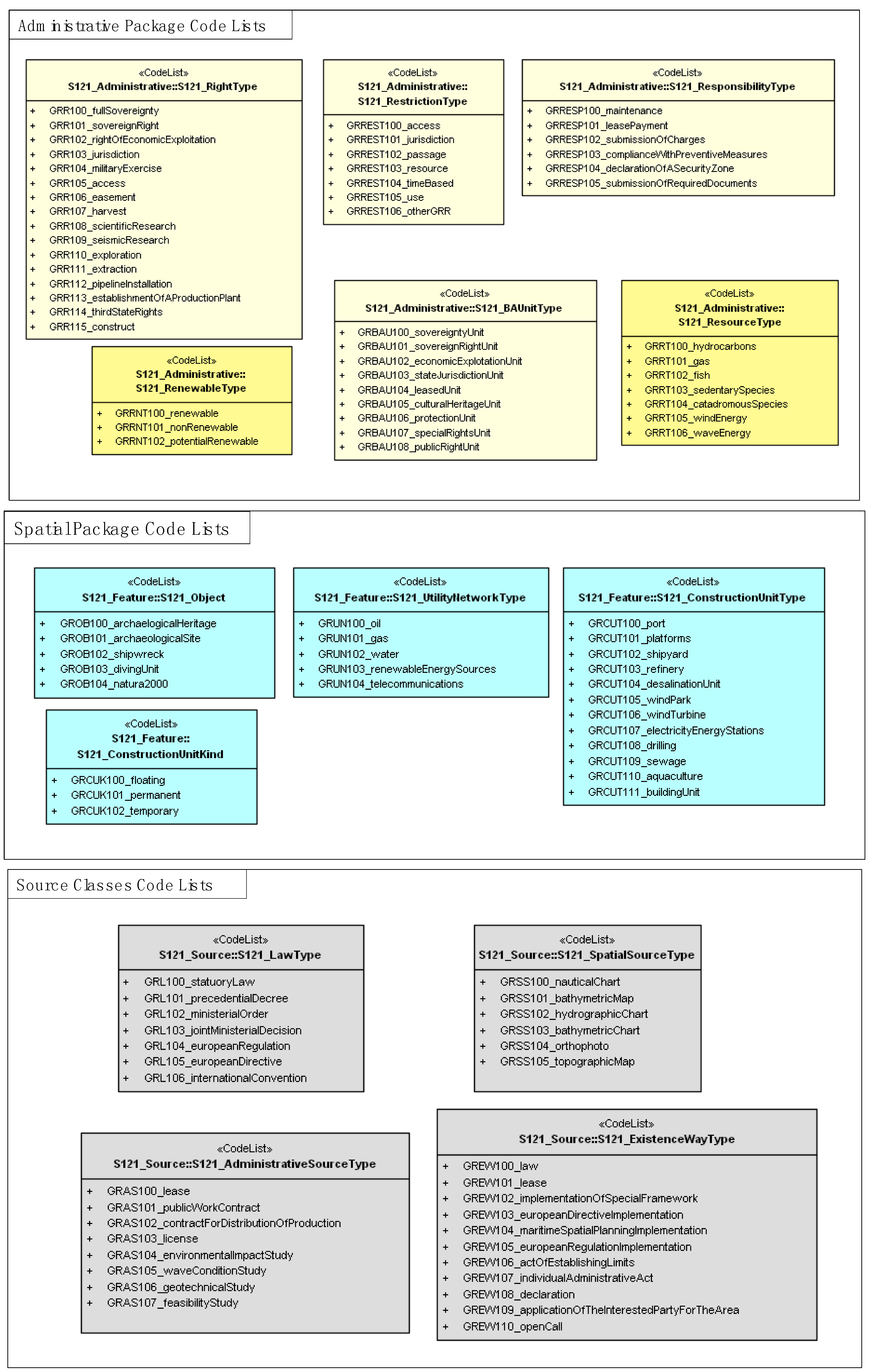
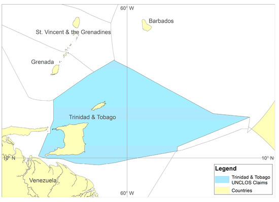
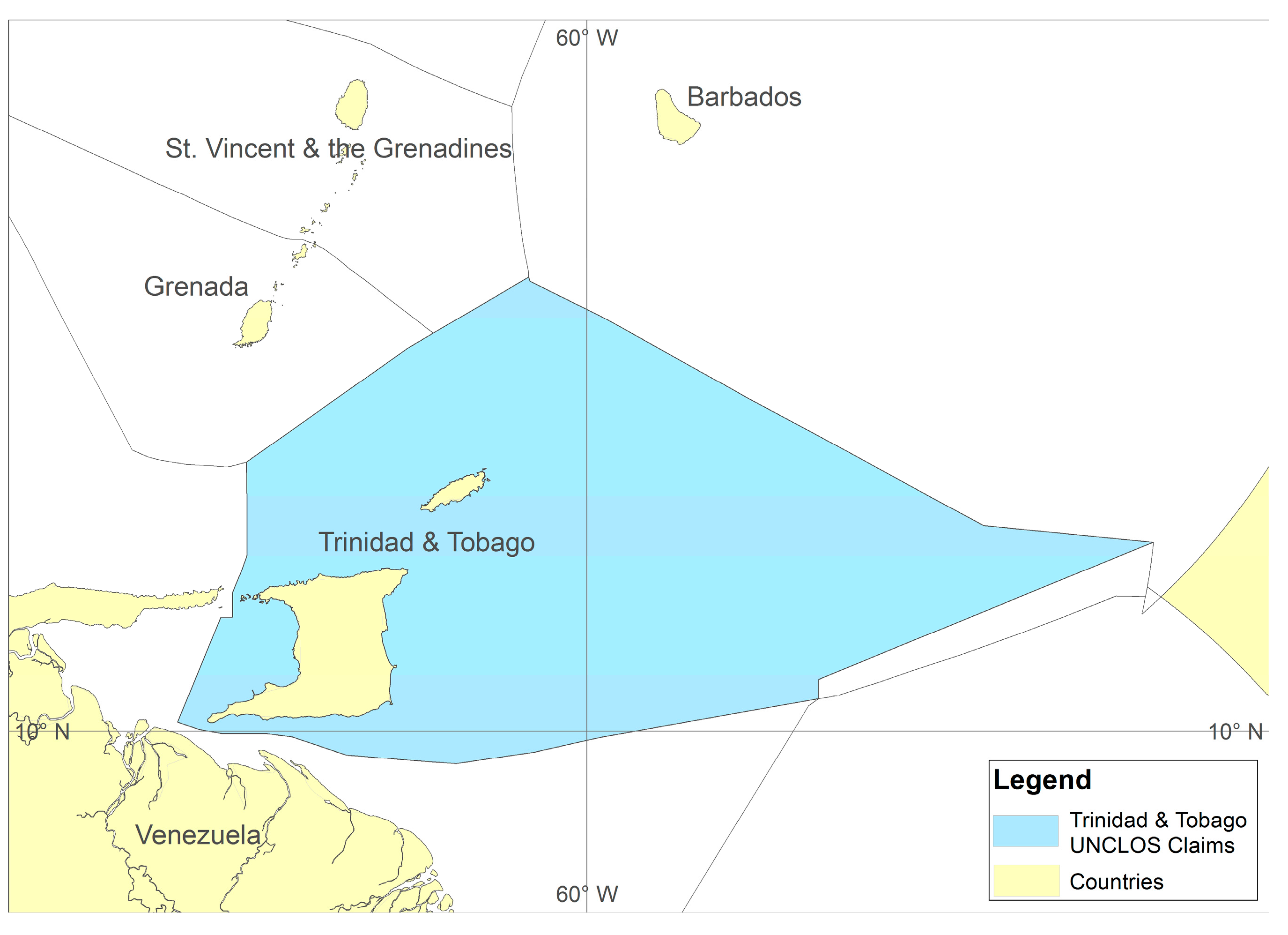
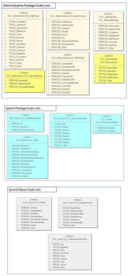
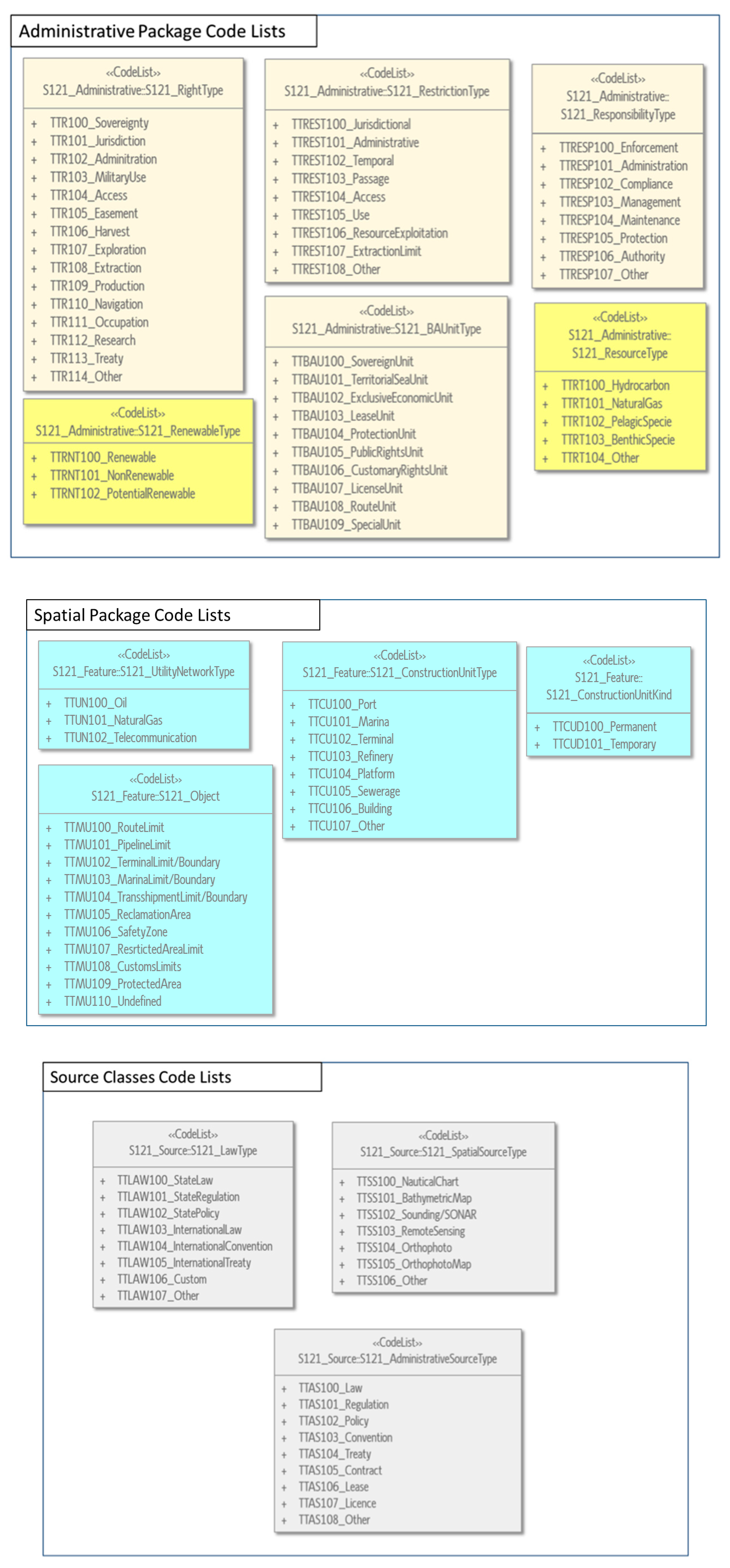
The Republic of Trinidad and Tobago (Figure 12) is a Caribbean archipelagic twin-island country that is located approximately seven kilometers off the northeastern coast of Venezuela. It is the wealthiest country among Caribbean States, mostly because of oil and natural gas deposits in land and marine spaces under its sovereignty. Apart from oil and natural gas, the country’s marine spaces are subject to a variety of other marine and maritime interests and rights relating to navigation and fishing, among others. Trinidad and Tobago ratified the United Nations Convention on the Law of the Sea on 25 April 1986. To manage all the marine RRRs in the country, the development of an MAS based on international standards such as S-121 would be ideal. This section presents code lists that would be applicable (Figure 13), should such an MAS be considered for development.
Figure 12.
Trinidad and Tobago UNCLOS claim.
Figure 13.
Code Lists for S121 Party, S121 Administrative, S121 Spatial Packages and Source Classes for Trinidad and Tobago.
7. Results
The emphasis of S-121 is on the legal description of marine objects. Different descriptions of legal rights and associated restrictions and responsibilities can be defined for multiple parties, even if these parties have potentially different and conflicting claims. The introduction of class marine resources is considered as critical since the ultimate goal in the administration and management of marine environment is sustainability and protection of the resources.
The definition of the code list values, according to each country legal regime, is considered as an important aspect in the implementation of S-121, while adjusting and extending the predefined values proposed by S-121 is also considered necessary. Regarding the comparison between the values of Greece and Trinidad and Tobago, it seems that, in their vast majority, they share a large common part. Some differences have been identified in the levels of responsible government, due to the different governmental structures and in the RRR types in regards to the different legislation systems.
8. Conclusions
Recent research focuses on regulating the establishment of basic principles, semantics, rules and procedures relating to the creation of an MAS. So far, standardization is a requirement to support the development of a National Land Information System. The same applies to the marine environment, since the term “land” encompasses the water element, as [33] states. S-100 provides the appropriate tools and framework to develop and maintain hydrography related data, products and registers. The extension of this standard to support the LADM, in order to include the registration of additional types of marine data, specified by the law is addressed through the development of S-121. S-121 may serve as the bridge between the land and marine domains while the MLB following the S-121 standard may be used in the marine administration domain. Part of the S-121 project development is the specialization of the generic code lists of the various attributes to marine environment for every state. Proposed values are given for the implementation of the model in Greece and Trinidad and Tobago.
Additionally, this paper addresses several issues that relate to the development of S-121 data model, as follows:
- The introduction of class marine resources into the model. The ultimate objective for the development and implementation of an MAS for the management of the legitimate interests is the conservation of the marine resources in the context of sustainable development.
- The integration of data on legal spaces and on physical features through the external classes into the specializations of MLB Space Object.
- The division of Sources into S121_Law and S121_AdministrativeSource. In marine environments, the existence of rights may be not created through transaction, but derive from the law.
- Regarding the Greek case, a conclusive approach is gradually an issue of growing priority, to support the state and European MSP initiatives. Determining maritime boundaries with its neighbors needs to be agreed, in order to define the area where the MAS applies. In addition, a national ocean’s policy would be a first step towards the development of an MAS to manage the complex legal regime and overlapping jurisdictions, based on S-121 product specification.
- Organization of national marine legislation, considering EU orientations and directives in a structure similar of S-121. To this purpose, appropriate legislation should be introduced and maintain a database adapted to international standards. In this direction, any differences and conflicts in marine space need to be identified and resolved by specific regulations.
- Regarding the specialized code lists for Greece and Trinidad and Tobago as presented in Section 5, most of them have common values and the differences are to be found specifically in the RRR types and in the levels of responsible government. In the first place, the specialization of S-121 generic code lists is proposed, and, secondly, their adjustment, depending on the country needs.
Acknowledgments
The authors would sincerely like to thank Thijs Ligteringen, Hydrographic Service, Royal Netherlands Navy, Ministry of Defence, for providing the most recent documentation concerning S-121 Maritime Limits and Boundaries Standard.
Author Contributions
More specifically, Katerina Athanasiou carried out the main research for the potential application and modification of IHO S-121 to the marine and maritime administrative needs based on her diploma thesis, that took place at the School of Rural and Surveying Engineering of the National Technical University of Athens under the supervision of professor Efi Dimopoulou, and proposed the code lists for the Greek case. Similarly, Michael Sutherland, dealt with the review of modeling approaches applied to marine environment, developed a list of reasonable criteria that may apply to assess the LADM standard and proposed the code lists for Trinidad and Tobago, with supporting input from Charisse Griffith-Charles and Dexter Davis. Moreover, Lysandros Tsoulos and Christos Kastrisios supported the marine related international standards review and dealt with the spatial issues related to the marine environment. Finally, Efi Dimopoulou, provided important guidance concerning the methodological steps taken, by offering her critical review, improvements and expertise on this research field.
Conflicts of Interest
The authors declare no conflict of interest.
References
- Athanasiou, A.; Pispidikis, I.; Dimopoulou, E. 3D Marine Admininstration System Based ON LADM. In Proceedings of the 10th 3D Geoinfo Conference, Kuala Lumpur, Malaysia, 28–30 October 2015; Abdul-Rahman, A., Ed.; Springer Nature: Berlin, Germany, 2017; pp. 385–408. [Google Scholar]
- Nichols, S.; Ng’ang’a, S.M.; Sutherland, M.D.; Cockburn, S. Marine Cadast re Concept. In Canada’s Offshore: Jurisdiction, Rights and Management, 3rd ed.; Calderbank, B., MacLeod, A.M., McDorman, T.L., Gray, D.L., Eds.; Trafford Publishing: Bloomington, IN, USA, 2006; Chapter 10. [Google Scholar]
- Arvanitis, A. Development of an Integrated Geographical Information System for the Marine Space. Ph.D. Thesis, School of Rural and Surveying Engineering, Aristotle University of Thessaloniki, Thessaloniki, Greece, 2013. [Google Scholar]
- Rajabifard, A.; Binns, A.; Williamson, I. Administering the Marine Environment. The Spatial Dimension. J. Spat. Sci. 2005, 50, 69–78. [Google Scholar] [CrossRef] [Scilit]
- Rajabifard, A.; Williamson, I.; Binns, A. Marine Administration Research Activities within Asia and Pacific Region—Towards a Seamless Land-Sea Interface; Publication No. 36, International Issues; FIG, Administering Marine Spaces: Copenhagen, Denmark, 2006; pp. 21–36. [Google Scholar]
- Strain, L.; Rajabifard, A.; Williamson, I.P. Marine Administration and Spatial Data Infrastructure. Mar. Policy 2006, 30, 431–441. [Google Scholar] [CrossRef] [Scilit]
- Widodo, M.S. The Needs for Marine Cadastre and Supports of Spatial Data Infrastructures in Marine Environment—A Case Study. In Proceedings of the FIG Working Week, Paris, France, 13–17 April 2003. [Google Scholar]
- Widodo, M.S. Relationship of Marine Cadastre and Marine Spatial Planning in Indonesia. In Proceedings of the 3rd FIG Regional Conference, Jakarta, Indonesia, 3–7 October 2004. [Google Scholar]
- Widodo, S.; Leach, J.; Williamson, I.P. Marine Cadastre and Spatial Data Infrastructures in Marine Environment. In Proceedings of the Joint AURISA and Institution of Surveyors Conference, Adelaide, Australia, 25–30 November 2002. [Google Scholar]
- Arvanitis, A.; Giannakopoulou, S.; Parri, I. Marine Cadastre to Support Marine Spatial Planning. In Proceedings of the Common Vision Conference 2016 Migration to a Smart World, EULIS, Amsterdam, The Netherlands, 5–7 June 2016. [Google Scholar]
- De Latte, G. Marine Cadastre—Legal Framework UNCLOS & EU legislation. In Proceedings of the Common Vision Conference 2016 Migration to a Smart World, EULIS, Amsterdam, The Netherlands, 5–7 June 2016. [Google Scholar]
- Ng’ang’a, S.M.; Sutherland, M.; Cockburn, S.; Nichols, S. Toward a 3D marine Cadastre in support of good ocean governance: A review of the technical framework requirements. Comput. Environ. Urban Syst. J. 2004, 28, 443–470. [Google Scholar] [CrossRef] [Scilit]
- Duncan, E.E.; Rahman, A. A Multipurpose Cadastral Framework for Developing Countries—Concepts. Electron. J. Inf. Syst. Dev. Ctries. 2013, 58, 1–16. [Google Scholar]
- Griffith-Charles, C.; Sutherland, M.D. Governance in 3D, LADM Compliant Marine Cadastres. In Proceedings of the 4th International Workshop on 3D Cadastres, Dubai, UAE, 9–11 November 2014; pp. 83–98. [Google Scholar]
- Sutherland, M.D.; Griffith-Charles, C.; Davis, D. Toward the Development of LADM-based Marine Cadastres: Is LADM Applicable to Marine Cadastres? In Proceedings of the 5th International FIG 3D Cadastre Workshop, Athens, Greece, 18–20 October 2016; pp. 301–315. [Google Scholar]
- Athanasiou, A. Marine Administration Model for Greece, based on LADM. Bachelor’s Thesis, Department of Spatial Planning and Regional Development, School of Rural and Surveying Engineering, National and Technical University of Athens, Athens, Greece, 2014. [Google Scholar]
- Athanasiou, A.; Dimopoulou, E.; Kastrisios, C.; Tsoulos, L. Management of Marine Rights, Restrictions and Responsibilities according to International Standards. In Proceedings of the 5th International FIG 3D Cadastre Workshop, Athens, Greece, 18–20 October 2016; pp. 81–104. [Google Scholar]
- IHO S-121. Product Specification for Maritime Limits and Boundaries. Available online: https://www.google.com/url?sa=t&rct=j&q=&esrc=s&source=web&cd=1&ved=0ahUKEwjhwZniv9DUAhUlCcAKHbrGBvEQFggiMAA&url=https%3A%2F%2Fwww.iho.int%2Fmtg_docs%2Fcom_wg%2FS-100WG%2FS-121PT%2FS121%2520Draft%2520Product%2520Specification%2520Revised%252001%2520Dec%252016%2520v2.3.8.docx&usg=AFQjCNFv_PaTC96xHdMRr9tigRZ6s9ERLg&cad=rja (accessed on 1 December 2016).
- Lemmen, C.H.J. A Domain Model for Land Administration. Ph.D. Thesis, Technical University of Delft, Delft, The Netherlands, 2012. [Google Scholar]
- Canadian Hydrographic Service; Geoscience Australia. Supporting the ISO 19152 Land Administration Domain Model in a Marine Environment. Available online: https://www.iho.int/mtg_docs/com_wg/S-100WG/S-100WG1/S100WG01-10.3A_IHOPaper_IntegrationOfLADM_Rev1.pdf (accessed on 26 February 2016).
- Fowler, C.; Tremi, E. Building a marine cadastral information system for the United States—A case study. Comput. Environ. Urban Syst. 2001, 6, 493–507. [Google Scholar] [CrossRef] [Scilit]
- Collier, P.; Leahy, F.; Williamson, I. Defining a Marine Cadastre for Australia. In Proceedings of the Institute of Australian Surveyors Annual Conference, Brisbane, Australia, 25–28 September 2001. [Google Scholar]
- Hirst, B.; Robertson, D. Law of the Sea Boundaries in a Marine Cadastre. In Proceedings of the Institute of Australian Surveyors Annual Conference, Brisbane, Australia, 25–28 September 2001. [Google Scholar]
- Todd, P. Marine Cadaster—Opportunities and Implications for Queensland. In Proceedings of the Institute of Australian Surveyors Annual Conference, Brisbane, Australia, 25–28 September 2001. [Google Scholar]
- Sutherland, M.; Nichols, S.; Monahan, D. Marine Boundary Delimitation for Ocean Governance. In Proceedings of the Institute of Australian Surveyors Annual Conference, Brisbane, Australia, 25–28 September 2001. [Google Scholar]
- Ng’ang’a, S.M.; Nichols, S.; Sutherland, M.; Cockburn, S. Toward a Multidimensional Marine Cadastre in Support of Good Ocean Governance; New Spatial Information Management Tools and their Role in Natural Resource Management. In Proceedings of the International Conference on Spatial Information for Sustainable Development, Nairobi, Kenya, 2–5 October 2001. [Google Scholar]
- Ng’ang’a, S.M.; Sutherland, M.; Nichols, S. Data Integration and Visualisation Requirements for a Canadian Marine Cadastre: Lessons from the Proposed Musquash Marine Protected Area. In Proceedings of the ISPRS Commission IV, Ottawa, ON, Canada, 9–12 July 2002. [Google Scholar]
- Binns, A.; Rajabifard, A.; Collier, P.A.; Williamson, I.P. Developing the concept of a marine cadastre: An Australian case study. Trans-Tasman Surv. 2004, 6, 19–27. [Google Scholar]
- Binns, A. Building a National Marine Initiative through the Development of a Marine Cadastre for Australia. In Proceedings of the East Asian Seas Congress, Kuala Lumpur, Malaysia, 8–12 December 2003. [Google Scholar]
- Peyton, D.; Kuwalek, E.; Fadaie, K. Managing Hydrographic and Oceanographic Information for Maritime Spatial Data Infrastructure: New Paths. New Approaches. Available online: http://slideplayer.com/slide/9352316/ (accessed on 28 August 2016).
- Sutherland, M. Marine Boundaries and the Governance of Marine Spaces; Technical Report No. 232; University of New Brunswick: Fredericton, NB, Canada, 2005; p. 372. [Google Scholar]
- Sutherland, M.; Nichols, S. Issues in the governance of marine spaces. In Administering Marine Spaces; International Issues, FIG Publication No. 36; Sutherland, M., Ed.; International Federation of Surveyors: Copenhagen, Denmark, 2006; pp. 6–20. [Google Scholar]
- ISO 19152. Geographic Information—Land Administration Domain Model. Available online: https://www.iso.org/standard/51206.html (accessed on 25 October 2012).
- Aien, A.; Kalantari, M.; Rajabifard, A.; Williamson, I.; Bennett, R. Utilizing Data Modeling to Understand the Structure of 3D Cadastres. J. Spat. Sci. 2013, 58, 215–234. [Google Scholar] [CrossRef] [Scilit]
- IHO S-100. Universal Hydrographic Data Model; Publication S-100; 2.0.0; International Hydrographic Organization (IHO): Monaco, 2015. [Google Scholar]
- McGregor, M. S-10X Maritime Boundary Product Specification—Explanatory Notes. Presented at the 26th IHO Transfer Standard Maintenance and Application Development Working Group (TSMAD) and the 5th Digital Information Portrayal Working Group (DIPWG), Silver Spring, MD, USA, 10–14 June 2013. [Google Scholar]
- Longhorn, R. Assessing the Impact of INSPIRE on Related EU Marine Directives. In Proceedings of the Hydro12 Conference, Rotterdam, The Netherlands, 13 November 2012. [Google Scholar]
- Millard, K. Inspire ‘Marine’—Bringing Land and Sea Together; HR Wallingford: London, UK, 2007. [Google Scholar]
- Nichols, S. Land Registration in an Information Management Environment. Ph.D. Thesis, Department of Surveying Engineering, University of New Brunswick, Fredericton, NB, Canada, 1992; p. 340. [Google Scholar]
- Ng’ang’a, S. Extending Land Management Approaches to Coastal and Oceans Management: A Framework for Evaluating the Role of Tenure Information in Canadian Marine Protected Areas; ProQuest: Ann Arbor, MI, USA, 2006. [Google Scholar]
- Barry, M.; Elema, I.; van der Molen, P. Ocean Governance in the Netherlands North Sea. New Professional Tasks. Marine Cadastres and Coastal Management. In Proceedings of the FIG Working Week, Paris, France, 13–17 April 2003. [Google Scholar]
- Kalantari, M.; Rajabifard, A.; Wallace, J.; Williamson, I. Spatially referenced legal property objects. J. Land Use Policy 2008, 25, 173–181. [Google Scholar] [CrossRef] [Scilit]
- Rahman, A.; van Oosterom, P.; Hua, T.H.; Sharkawi, K.H.; Duncan, E.E. 3D Modelling for Multipurpose Cadastre. In Proceedings of the 3th International Workshop on 3D Cadastres, Shenzhen, China, 25–26 October 2012; pp. 185–202. [Google Scholar]
- NOAA. An Ocean of Information. Available online: http://marinecadastre.gov (accessed on 5 August 2016).
- BOEMRE. Development of Marine Boundaries and Offshore Leases. Management of Marine Resources. Available online: http://www.mcatoolkit.org/pdf/ISLMC_11/Marine_Boundaries_Offshore_Lease_Areas_Management.pdf (accessed on 5 July 2014).
- Beazley, P.B. Technical Aspects of Maritime Boundary Delimitation; International Research Unit, Durham University: Durham, UK, 1994; Volume 1. [Google Scholar]
- Leahy, F.J.; Murphy, B.A.; Collier, P.A.; Mitchell, D.J. Uncertainty Issues in the Geodetic Delimitation of maritime Boundaries. In Proceedings of the International Conference on Accuracies and Uncertainties, Issues in Maritime Boundaries and Outer Limits, International Hydrographic Bureau, Monaco, 18–19 October 2001. [Google Scholar]
- Carrera, G. Lecture Notes on Maritime Boundary Delimitation; University of Durham: Durham, UK, 1999. [Google Scholar]
- Kastrisios, C.; Pilikou, M. Nautical Cartography Competences and their Effect to the Realisation of a Worldwide Official ENC Database, the Performance of ECDIS and the Fulfillment of IMO Chart Carriage Requirement. Mar. Policy 2017, 75, 29–40. [Google Scholar] [CrossRef] [Scilit]

© 2017 by the authors. Licensee MDPI, Basel, Switzerland. This article is an open access article distributed under the terms and conditions of the Creative Commons Attribution (CC BY) license (http://creativecommons.org/licenses/by/4.0/).