An Automated Processing Algorithm for Flat Areas Resulting from DEM Filling and Interpolation


Abstract
:1. Introduction
2. Methodology
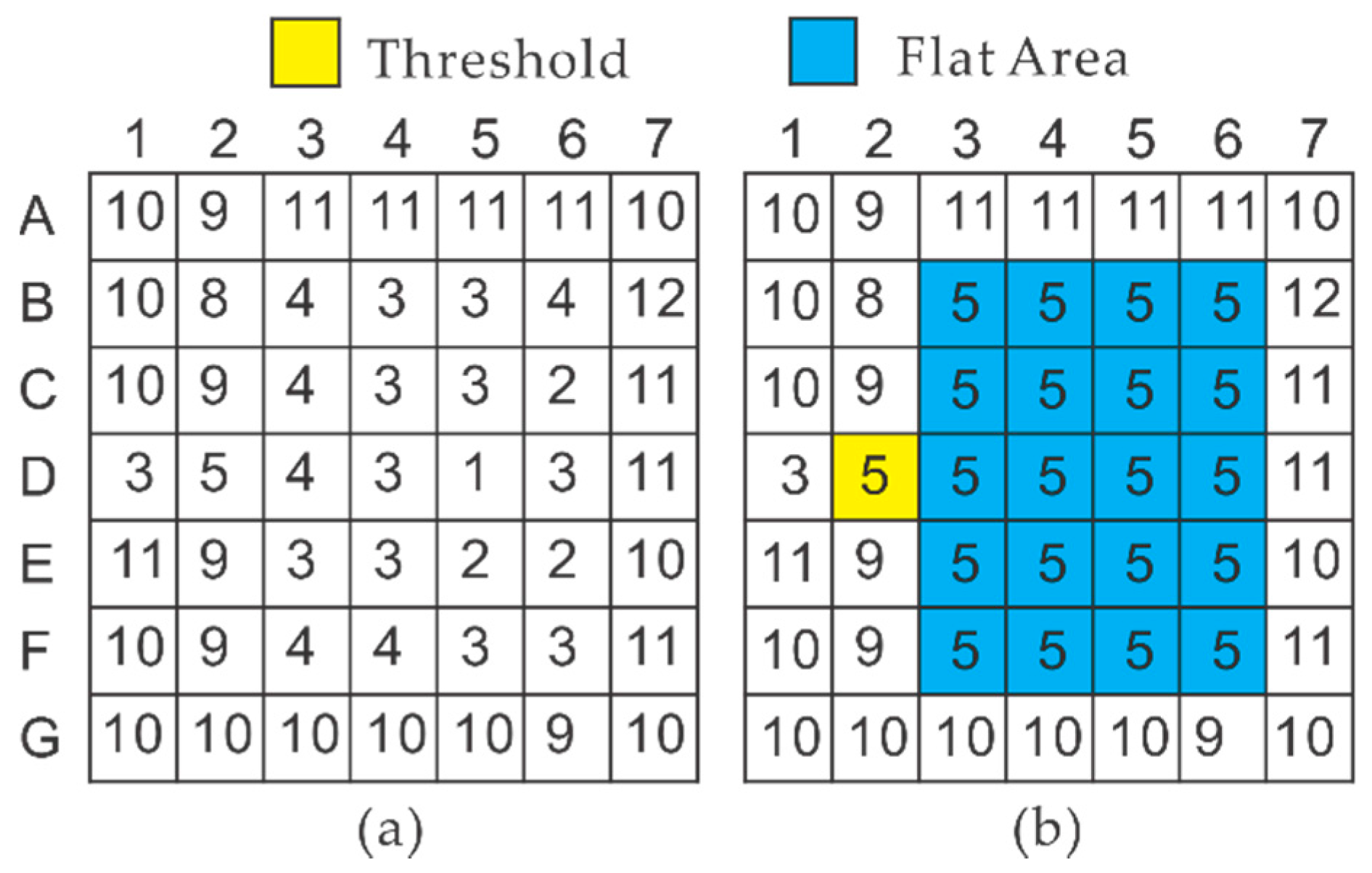
2.1. Flat Area Correcting Procedure
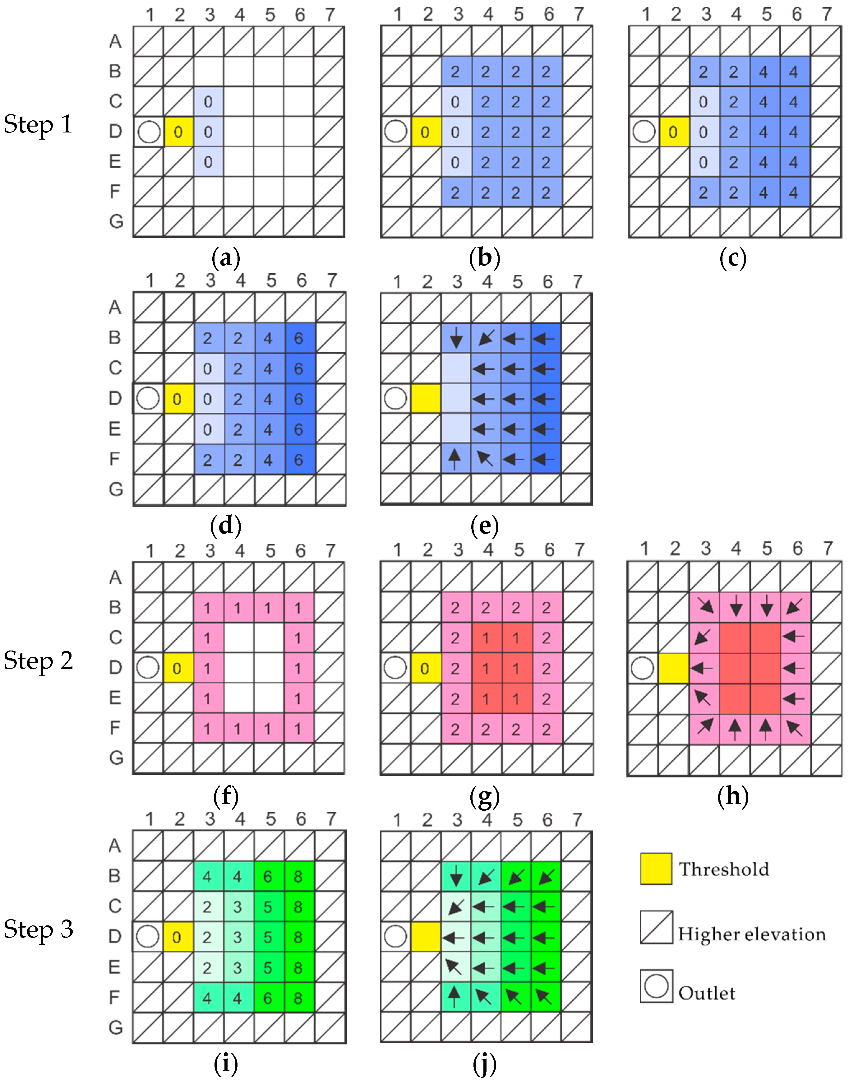
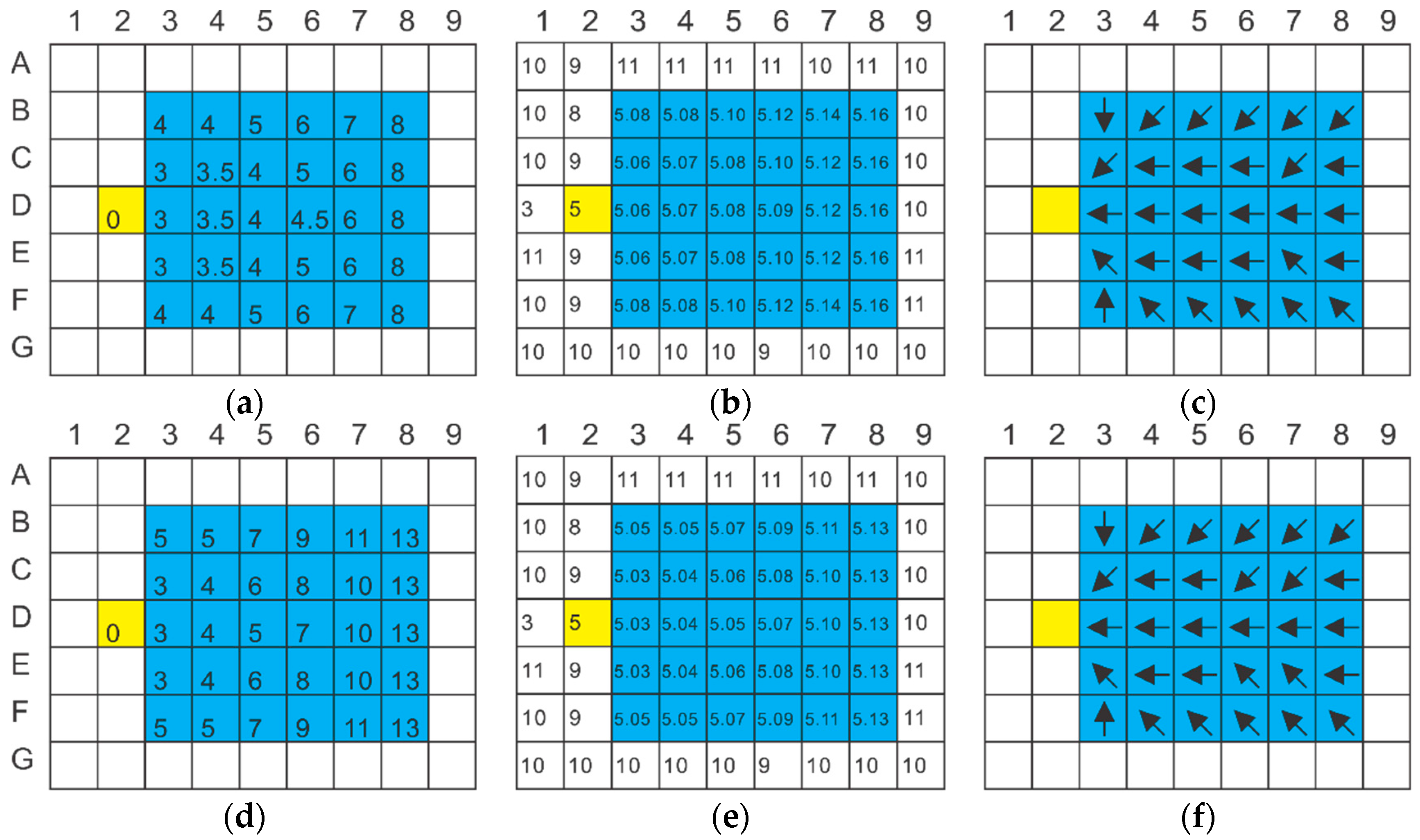
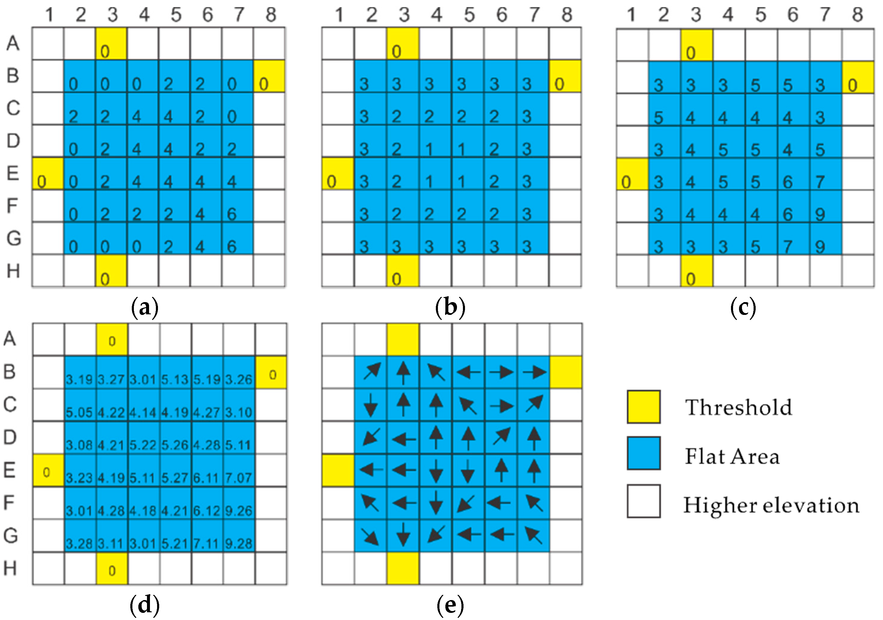
2.1.1. Step 1: Making Flow toward Thresholds
2.1.2. Step 2: Making Flow toward Centers
2.1.3. Step 3: Creating Artificial Slopes
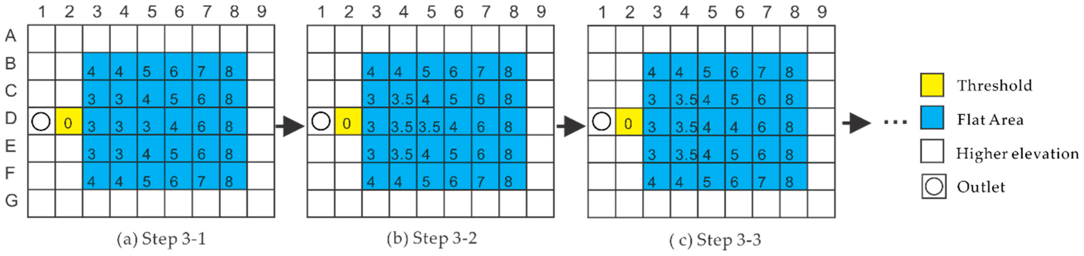
2.1.4. Step 4: Correcting New Flats and Multiple Flow Direction Cells
2.2. Introduction to DEDNM
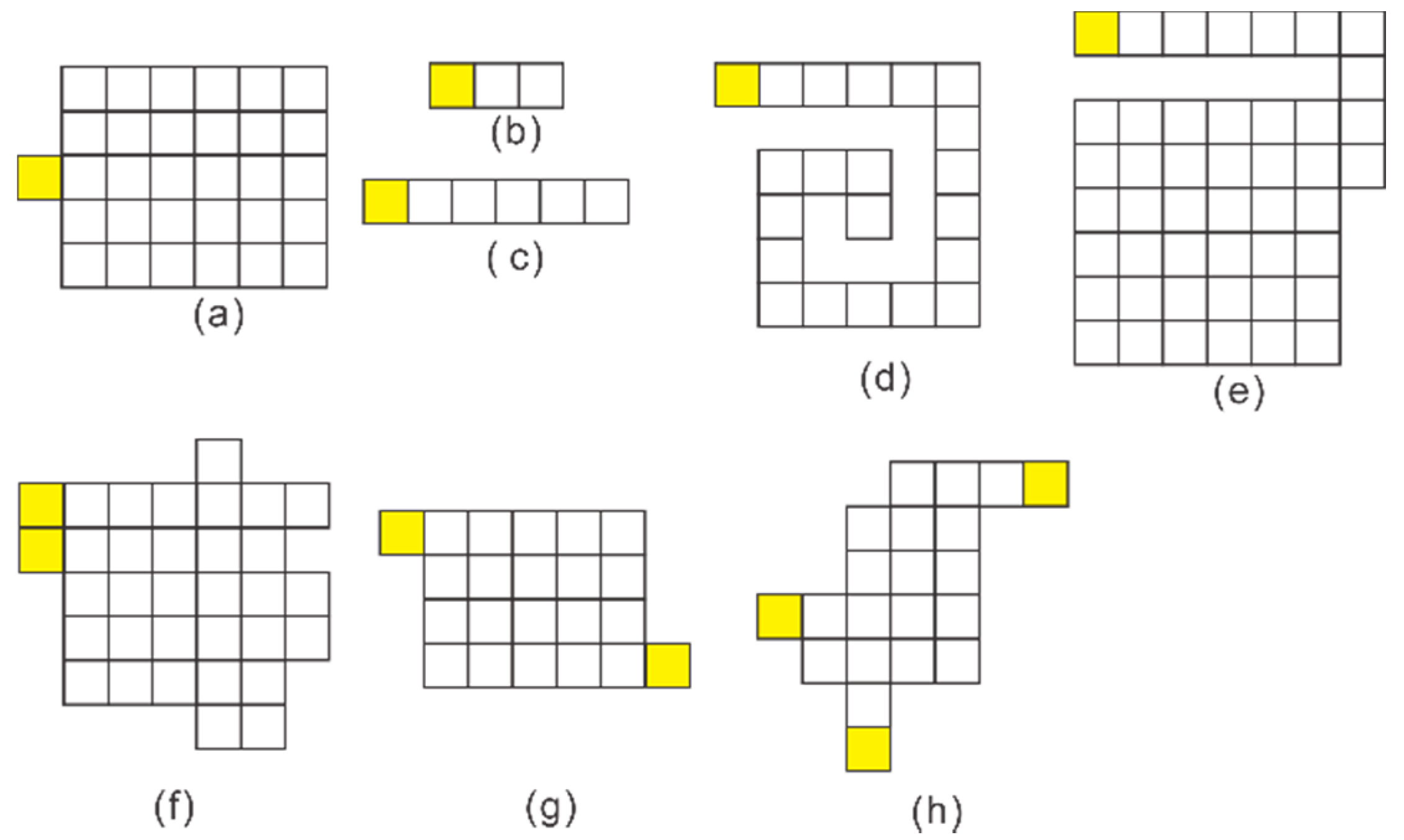
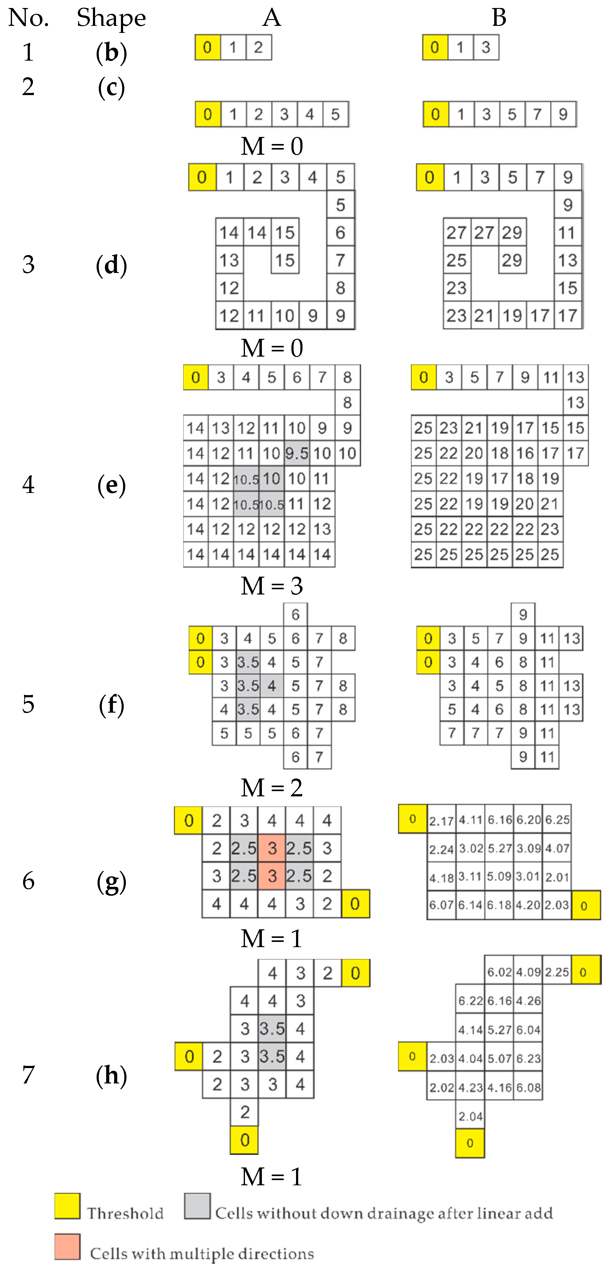
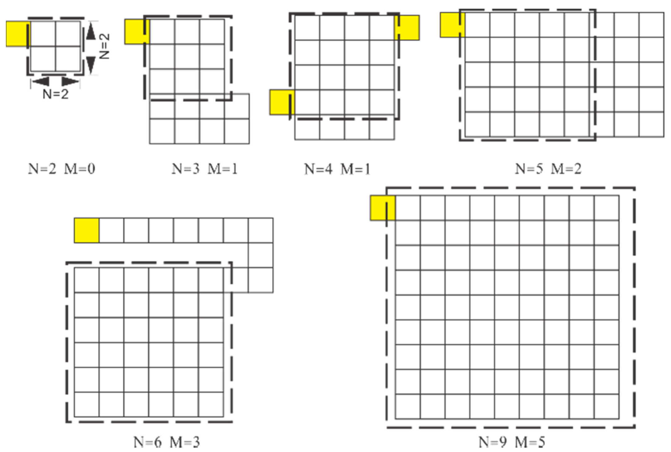
2.3. Testing of the New Flat Correction Algorithm
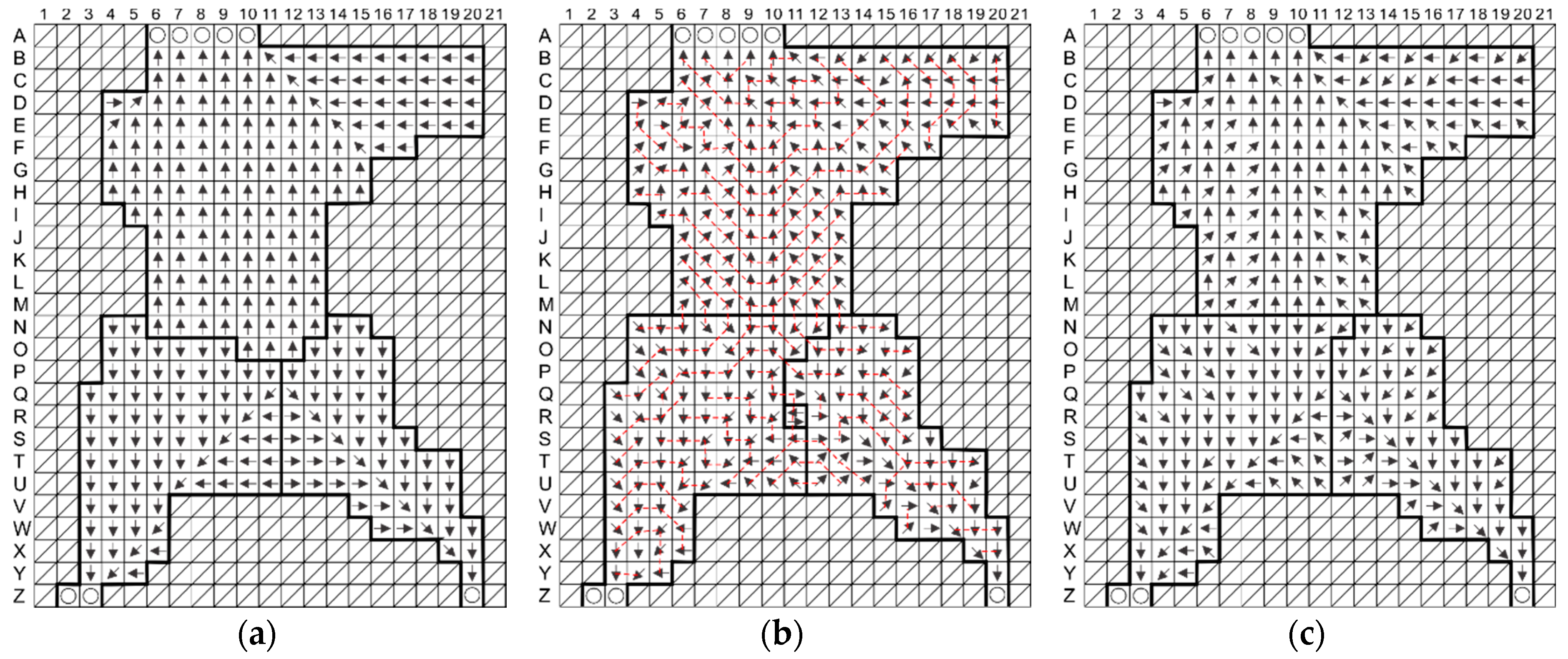
3. Results and Analysis
3.1. Correction of Simple Flats
3.2. Correction of Complex Flats
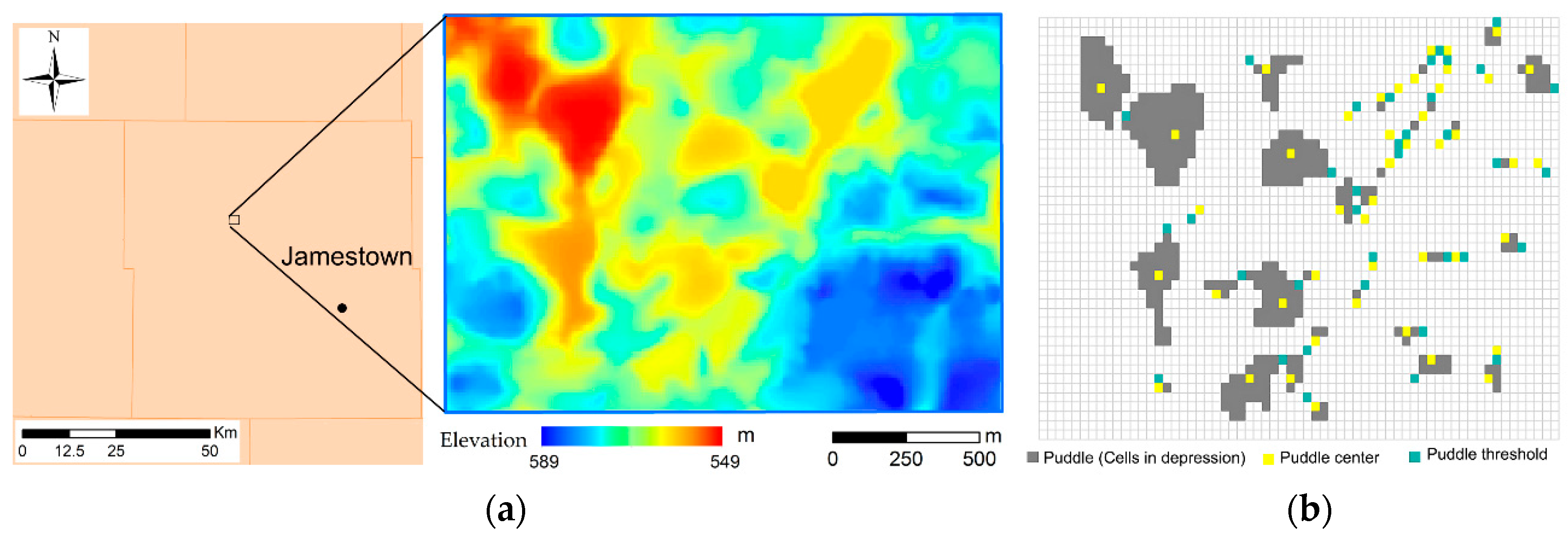
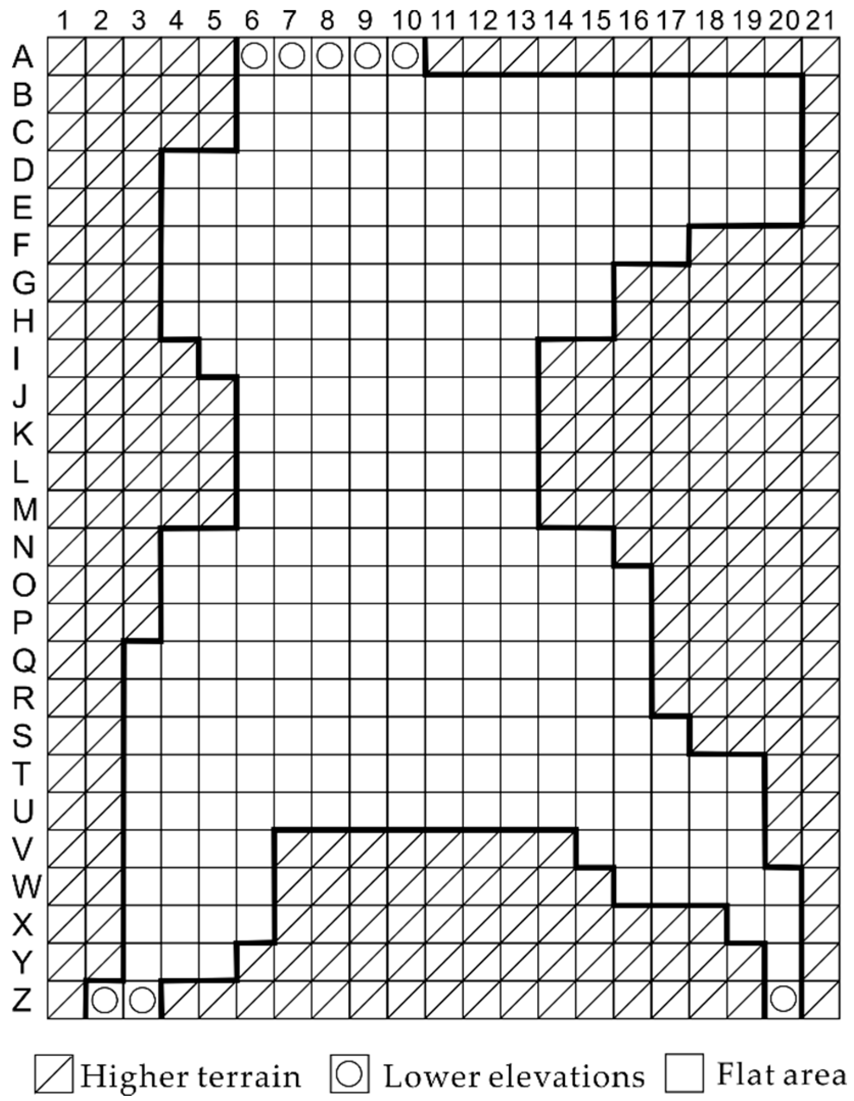
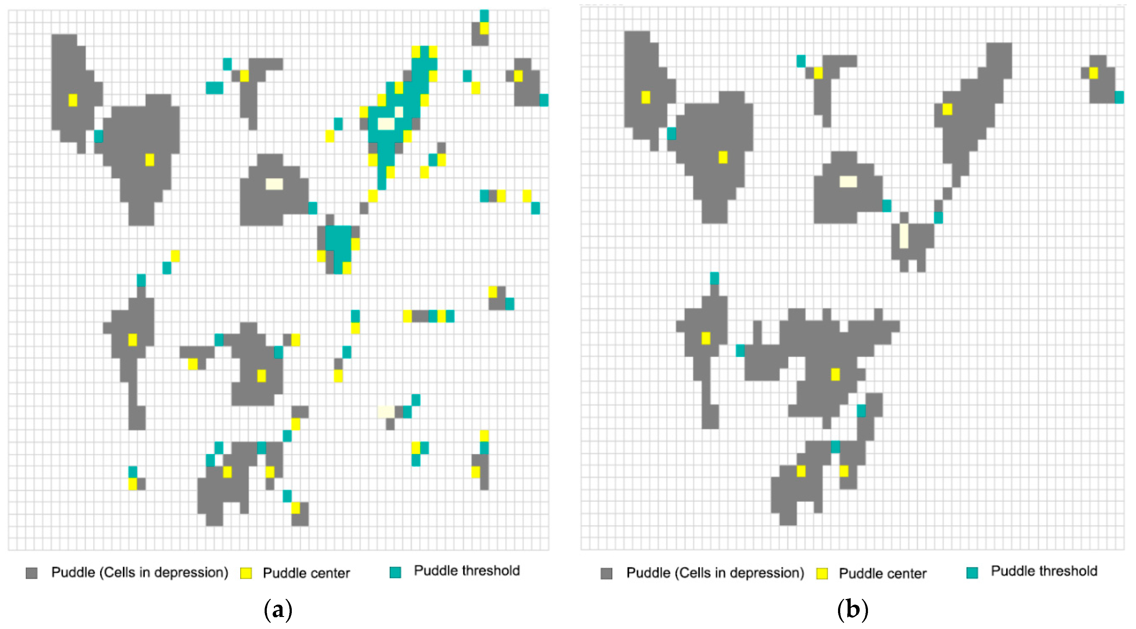
3.3. Correction of Real Depressions/Flats
4. Conclusions
Acknowledgments
Author Contributions
Conflicts of Interest
References
- Nasab, M.T.; Zhang, J.; Chu, X. A new depression-dominated delineation (D-cubed) method for improved watershed modeling. Hydrol. Process. 2017. [Google Scholar] [CrossRef]
- Chu, X.; Yang, J.; Chi, Y.; Zhang, J. Dynamic puddle delineation and modeling of puddle-to-puddle filling-spilling-merging-splitting overland flow processes. Water Resour. Res. 2013, 49, 3825–3829. [Google Scholar] [CrossRef]
- Zhang, W.H.; Montgomery, D.R. Digital elevation model grid size, landscape representation, and hydrologic simulations. Water Resour. Res. 1994, 30, 1019–1028. [Google Scholar] [CrossRef]
- Jain, M.K.; Singh, V.P. DEM-based modelling of surface runoff using diffusion wave equation. J. Hydrol. 2005, 302, 107–126. [Google Scholar] [CrossRef]
- Fairfield, J.; Leymarie, P. Drainage networks from grid digital elevation models. Water Resour. Res. 1991, 27, 709–717. [Google Scholar] [CrossRef]
- Grimaldi, S.; Teles, V.; Bras, R.L. Sensitivity of a physically based method for terrain interpolation to initial conditions and its conditioning on stream location. Earth Surf. Process. Landf. 2004, 29, 587–597. [Google Scholar] [CrossRef]
- Kenny, F.; Matthews, B.; Todd, K. Routing overland flow through sinks and flats in interpolated raster terrain surfaces. Comput. Geosci. 2008, 34, 1417–1430. [Google Scholar] [CrossRef]
- Grimaldi, S.; Teles, V.; Bras, R.L. Preserving first and second moments of the slope area relationship during the interpolation of digital elevation models. Adv. Water Resour. 2005, 28, 583–588. [Google Scholar] [CrossRef]
- Grimaldi, S.; Nardi, F.; Di Benedetto, F.; Istanbulluoglu, E.; Bras, R.L. A physically-based method for removing pits in digital elevation models. Adv. Water Resour. 2007, 30, 2151–2158. [Google Scholar] [CrossRef]
- Nardi, F.; Grimaldi, S.; Santini, M.; Petroselli, A.; Ubertini, L. Hydrogeomorphic properties of simulated drainage patterns using digital elevation models: The flat area issue/propriétés hydro-géomorphologiques de réseaux de drainage simulés à partir de modèles numériques de terrain: La question des zones planes. Hydrol. Sci. J. 2008, 53, 1176–1193. [Google Scholar] [CrossRef]
- Jenson, S.K.; Domingue, J.O. Extracting topographic structure from digital elevation data for geographic information system analysis. Photogramm. Eng. Remote Sens. 1988, 54, 1593–1600. [Google Scholar]
- Tribe, A. Automated recognition of valley lines and drainage networks from grid digital elevation models: A review and a new method. J. Hydrol. 1992, 139, 263–293. [Google Scholar] [CrossRef]
- O’Callaghan, J.F.; Mark, D.M. The extraction of drainage networks from digital elevation data. Comput. Vis. Graph. Image Process. 1984, 28, 323–344. [Google Scholar] [CrossRef]
- Pan, F.; Stieglitz, M.; McKane, R.B. An algorithm for treating flat areas and depressions in digital elevation models using linear interpolation. Water Resour. Res. 2012, 48. [Google Scholar] [CrossRef]
- Chu, X.; Zhang, J.; Chi, Y.; Yang, J. An improved method for watershed delineation and computation of surface depression storage. In Proceedings of the Watershed Management 2010: Innovations in Watershed Management under Land Use and Climate Change, Madison, WI, USA, 23–27 August 2010; pp. 1113–1122. [Google Scholar]
- Jana, R.; Reshmidevi, T.V.; Arun, P.S.; Eldho, T.I. An enhanced technique in construction of the discrete drainage network from low-resolution spatial database. Comput. Geosci. 2007, 33, 717–727. [Google Scholar] [CrossRef]
- Zhang, H.; Huang, G. Building channel networks for flat regions in digital elevation models. Hydrol. Process. 2009, 23, 2879–2887. [Google Scholar] [CrossRef]
- Zhang, S.; Zhao, B.; Erdun, E. Watershed characteristics extraction and subsequent terrain analysis based on digital elevation model in flat region. J. Hydrol. Eng. 2014, 19. [Google Scholar] [CrossRef]
- Su, C.; Wang, X.Z.; Feng, C.J.; Huang, Z.C.; Zhang, X.C. An integrated algorithm for depression filling and assignment of drainage directions over flat surfaces in digital elevation models. Earth Sci. Inform. 2015, 8, 895–905. [Google Scholar] [CrossRef]
- Su, C.; Feng, C.J.; Wang, X.Z.; Huang, Z.C.; Zhang, X.C. An efficient algorithm for assignment of flow direction over flat surfaces in raster DEMs based on distance transform. Earth Sci. Inform. 2016, 9, 225–233. [Google Scholar] [CrossRef]
- Zhang, H.; Yao, Z.; Yang, Q.; Li, S.; Baartman, J.E.; Gai, L.; Yao, M.; Yang, X.; Ritsema, C.J.; Geissen, V. An integrated algorithm to evaluate flow direction and flow accumulation in flat regions of hydrologically corrected DEMs. Catena 2017, 151, 174–181. [Google Scholar] [CrossRef]
- Garbrecht, J.; Martz, L.W. Automated channel ordering and node indexing for raster channel networks. Comput. Geosci. 1997, 23, 961–966. [Google Scholar] [CrossRef]
- Kite, G. Modelling the Mekong: Hydrological simulation for environmental impact studies. J. Hydrol. 2001, 253, 1–13. [Google Scholar] [CrossRef]
- Alsdorf, D.E. Water storage of the central amazon floodplain measured with GIS and remote sensing imagery. Ann. Assoc. Am. Geogr. 2003, 93, 55–66. [Google Scholar] [CrossRef]
- White, A.B.; Kumar, P.; Saco, P.M.; Rhoads, B.L.; Yen, B.C. Hydrodynamic and geomorphologic dispersion: Scale effects in the Illinois River basin. J. Hydrol. 2004, 288, 237–257. [Google Scholar] [CrossRef]
- Clennon, J.A.; King, C.H.; Muchiri, E.M.; Kitron, U. Hydrological modelling of snail dispersal patterns in Msambweni, Kenya and potential resurgence of Schistosoma haematobium transmission. Parasitology 2007, 134, 683–693. [Google Scholar] [CrossRef] [PubMed]
- Phillips, J.D.; Slattery, M.C. Downstream trends in discharge, slope, and stream power in a tower coastal plain river. J. Hydrol. 2007, 334, 290–303. [Google Scholar] [CrossRef]
- Clarke, S.E.; Burnett, K.M.; Miller, D.J. Modeling streams and hydrogeomorphic attributes in Oregon from digital and field data. J. Am. Water Resour. Assoc. 2008, 44, 459–477. [Google Scholar] [CrossRef]
- Barnes, R.; Lehman, C.; Mulla, D. An efficient assignment of drainage direction over flat surfaces in raster digital elevation models. Comput. Geosci. 2014, 62, 128–135. [Google Scholar] [CrossRef]
- Yang, J.; Chu, X.F. A new modeling approach for simulating microtopography-dominated, discontinuous overland flow on infiltrating surfaces. Adv. Water Resour. 2015, 78, 80–93. [Google Scholar] [CrossRef]
- Garbrecht, J.; Martz, L.W. The assignment of drainage direction over flat surfaces in raster digital elevation models. J. Hydrol. 1997, 193, 204–213. [Google Scholar] [CrossRef]
- Ormsby, T.; Napoleon, E.J.; Burke, R.; Groessl, C.; Bowden, L. Getting to Know Arcgis Desktop; Esri Press: Redlands, CA, USA, 2010; pp. 527–536. [Google Scholar]
- Chu, X. Delineation of pothole-dominated wetlands and modeling of their threshold behaviors. J. Hydrol. Eng. 2017, 22. [Google Scholar] [CrossRef]


| Surface/Shape | DEDNM | New Algorithm | Relative Difference (%) |
|---|---|---|---|
| (a) | 3.12 × 10⁻³ | 2.30 × 10⁻³ | 26.28 |
| (b) | 6.00 × 10⁻⁵ | 4.00 × 10⁻⁵ | 33.33 |
| (c) | 3.00 × 10⁻⁴ | 2.50 × 10⁻⁴ | 16.67 |
| (d) | 3.50 × 10⁻³ | 3.30 × 10⁻³ | 5.71 |
| (e) | 9.84 × 10⁻³ | 8.63 × 10⁻³ | 12.30 |
| (f) | 3.29 × 10⁻³ | 2.41 × 10⁻³ | 26.75 |
| (g) | 1.20 × 10⁻³ | 8.46 × 10⁻⁴ | 29.50 |
| (h) | 1.14 × 10⁻³ | 8.04 × 10⁻⁴ | 29.52 |
© 2017 by the authors. Licensee MDPI, Basel, Switzerland. This article is an open access article distributed under the terms and conditions of the Creative Commons Attribution (CC BY) license (http://creativecommons.org/licenses/by/4.0/).
Share and Cite
Liu, X.; Wang, N.; Shao, J.; Chu, X. An Automated Processing Algorithm for Flat Areas Resulting from DEM Filling and Interpolation. ISPRS Int. J. Geo-Inf. 2017, 6, 376. https://doi.org/10.3390/ijgi6110376
Liu X, Wang N, Shao J, Chu X. An Automated Processing Algorithm for Flat Areas Resulting from DEM Filling and Interpolation. ISPRS International Journal of Geo-Information. 2017; 6(11):376. https://doi.org/10.3390/ijgi6110376
Chicago/Turabian StyleLiu, Xingwei, Ning Wang, Jingli Shao, and Xuefeng Chu. 2017. "An Automated Processing Algorithm for Flat Areas Resulting from DEM Filling and Interpolation" ISPRS International Journal of Geo-Information 6, no. 11: 376. https://doi.org/10.3390/ijgi6110376
APA StyleLiu, X., Wang, N., Shao, J., & Chu, X. (2017). An Automated Processing Algorithm for Flat Areas Resulting from DEM Filling and Interpolation. ISPRS International Journal of Geo-Information, 6(11), 376. https://doi.org/10.3390/ijgi6110376