MDSR-KG: A Geographical Knowledge Graph Framework for Representing and Quantifying Spatial Relationships

Abstract
1. Introduction
- Core structural innovation: The framework uses the spatial relationship node-based representation tuple approach, elevating spatial relationships from simple edge structures to independent nodes that are rich in attributes. This provides a structured container for multidimensional relationship descriptions, thereby solving the problem of structured expression for complex spatial relationships.
- Core quantitative innovation: It adopts a parameterized relationship strength quantification method that integrates multiple dimensions of spatial relationships of geographic entities. This approach extends from establishing traditional binary relationships to ensuring continuous strength measurements. offering a quantitative foundation for analyzing the interactions between the geographic features in a geographic scenario.
- Engineering enabler: The framework offers an end-to-end automated graph construction workflow, delivering a practical solution for efficiently converting raw geographic data into inferable knowledge graphs.
2. Related Literature
3. Methodology
3.1. Framework
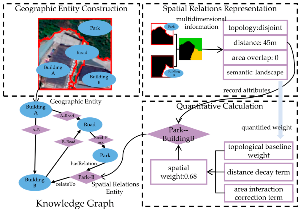
- Entity construction module: The module was based on geographic entity nodes [11,36], representing the objects in the scene (e.g., buildings, roads, and rivers). Each entity node integrated the semantic, geometric, and attribute information of the geographical object. Typically, the relevant information was extracted from RS data (such as satellite imagery and vector data) to generate the nodes.
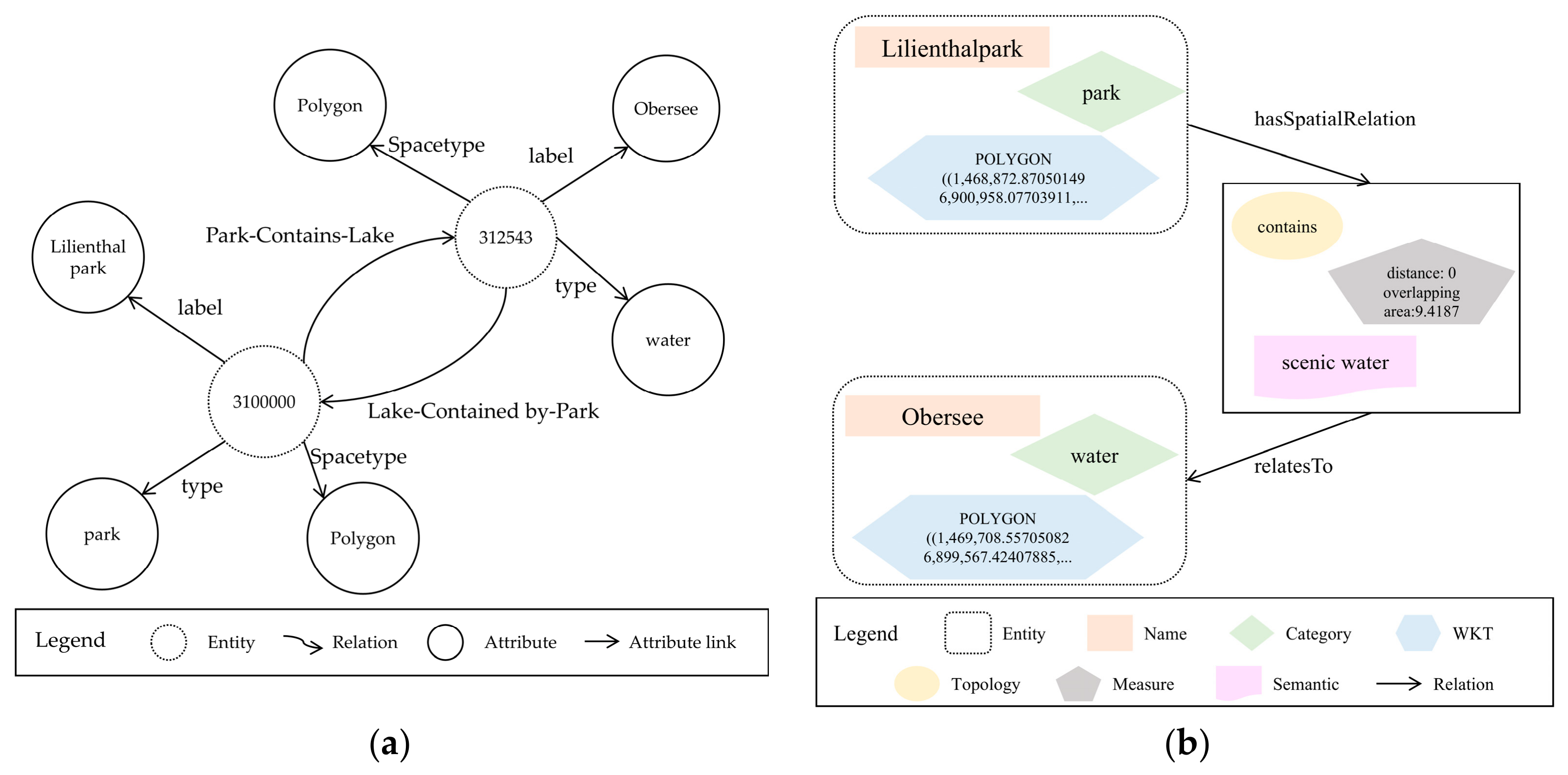
- Relationship representation module: The core of this module was the spatial relationship nodes, representing the spatial relationships between geographic objects (e.g., the spatial relationship between a lake and a park). The spatial relationships in the module were represented as independent entity nodes. The spatial relationship nodes integrated multidimensional geographic entity association information, including topology, metrics, and semantics.
- Quantitative calculation module: Based on the representation nodes for geographic entities and spatial relationships, it constructed a parameterized weight quantification algorithm for object associations within the scene by integrating multidimensional information of spatial relationships. The quantified weights measured the degree of mutual influence between geographical entities, thereby enhancing the knowledge graph’s reasoning capabilities for complex spatial relationships.
3.2. Core Components
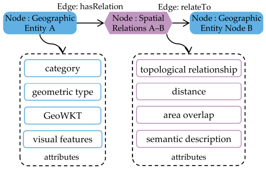
- Geographic entities: Geographic entities are independent objects in a real geographic environment, e.g., buildings, roads, water, and vegetation areas. Each entity is represented as an independent node in the knowledge graph, serving as the fundamental unit for spatial relationship analysis.
- Geographic entity attributes: Geographic entities can be comprehensively described through multiple types of attributes, including semantic, geometric, and spatial properties. Semantic attributes primarily include information, such as object type, functional classification, and name identifiers. Geometric attributes refer to measurable characteristics, such as the geometric shape, area, perimeter, and spatial extent of a geographic entity. Spatial attributes include location coordinates, boundary range, and bounding box.
- Spatial relationships: As the core innovation of the framework, spatial relationships are represented as independent nodes that define the spatial associations between geographic entities. This mode of representation breaks the limitations of traditional edge structures, providing a structured container for describing multidimensional relationships.
- Spatial relationship attributes: Spatial relationship nodes are described in detail through multidimensional attributes (e.g., topology, metric, and semantics). Topological attributes are based on the Open Geospatial Consortium’s (OGC) standard [43] for spatial connectivity logic (e.g., intersect, contain, and adjacent). Metric attributes describe the quantitative characteristics of spatial relationships (such as distance, orientation, and overlapping area). Semantic attributes refer to the functional associations and directional relationships between geographic entities.
3.3. Multidimensional Spatial Relationship Representation
3.3.1. Model Definition
3.3.2. Theoretical Analysis
3.4. Spatial Relationship Quantification
3.4.1. Spatial Weight Matrix
3.4.2. Determination of Parameters
3.4.3. Characteristics of the Quantification Model
4. Experiments and Results
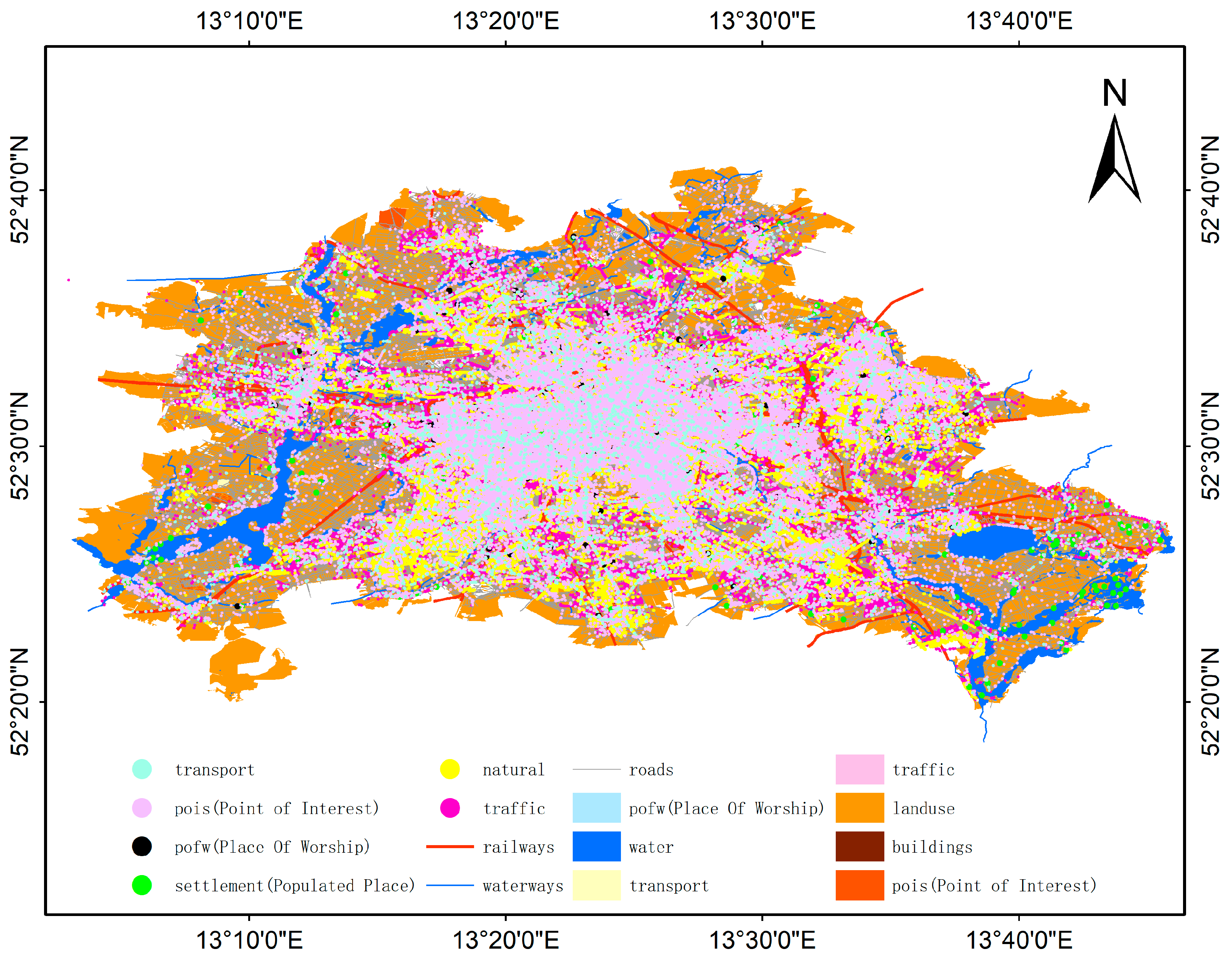
4.1. Data Sources and Study Area
4.2. Construction of Comparative Knowledge Graphs
4.2.1. Existing Models (YAGO, GeoKG, and HGeoKG)
4.2.2. MDSR-KG Model Proposed in This Study
4.3. Results and Analysis
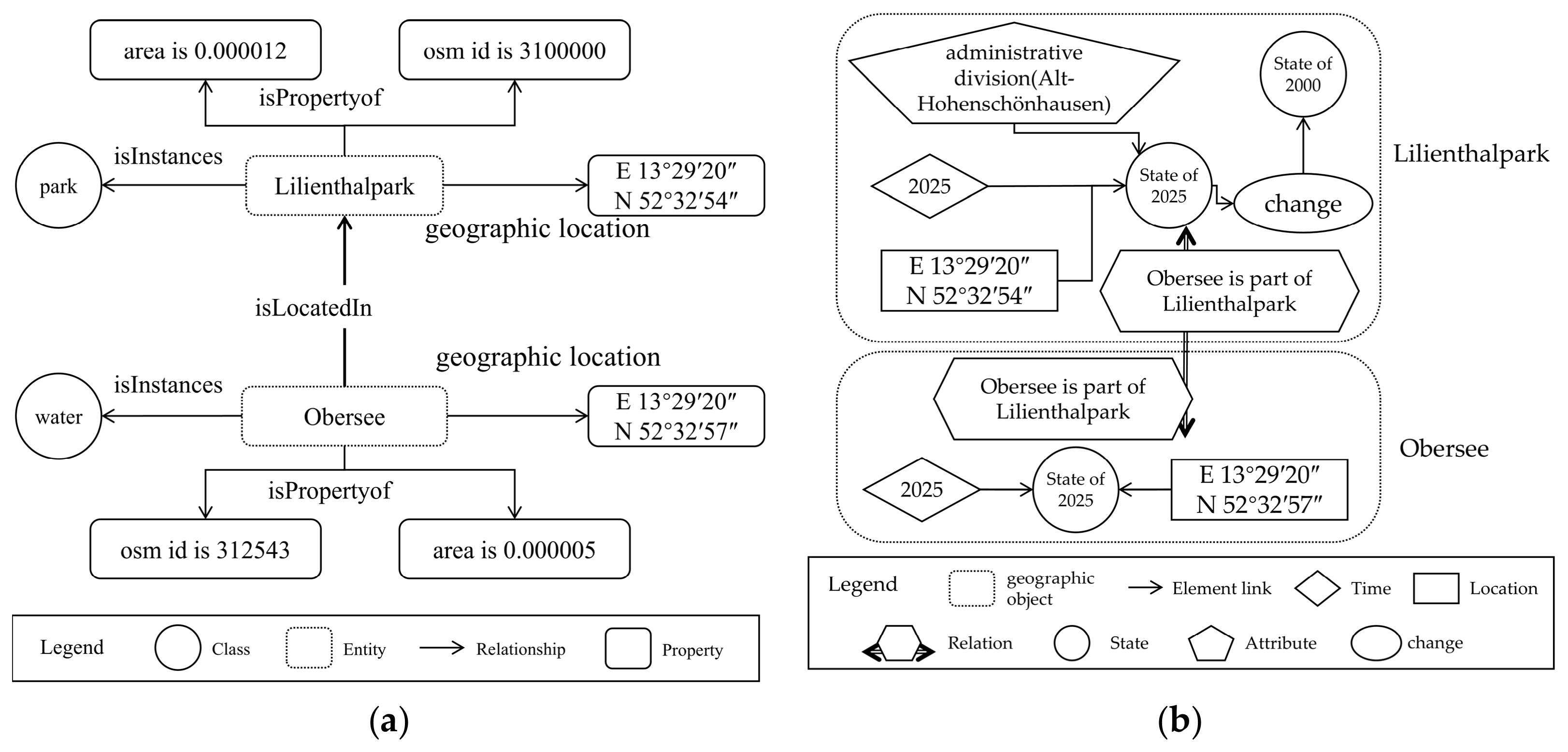
4.3.1. Comparison of Expressive Power
4.3.2. Verifying the Reasoning Capability of the Relationship Strength Quantification
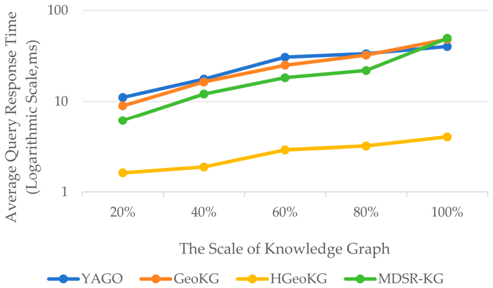
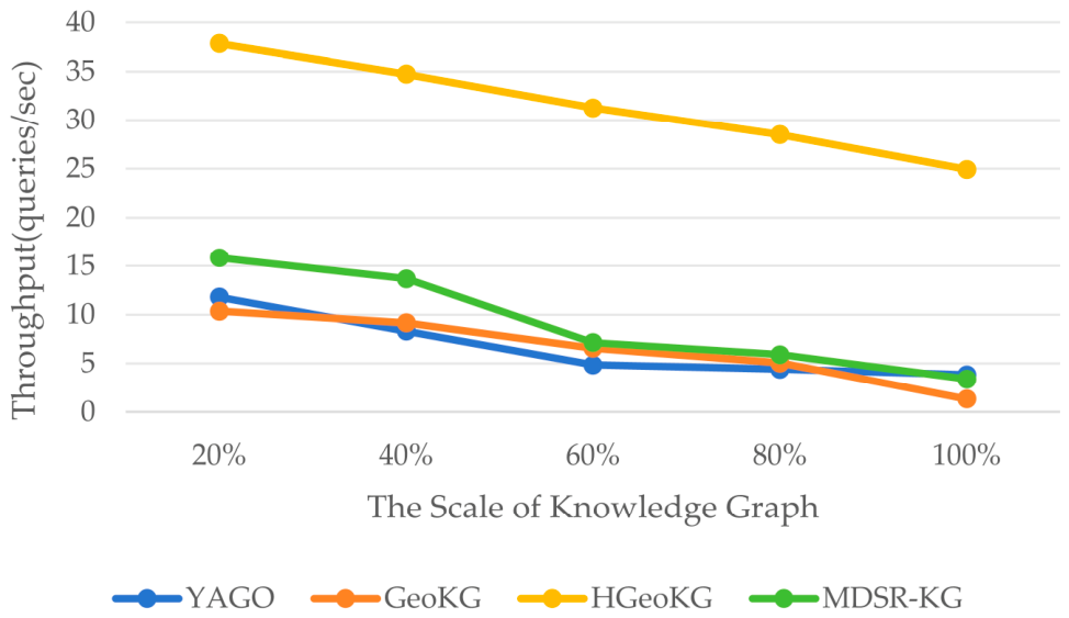
4.3.3. Scalability Analysis of the Proposed Model
4.4. Discussion
5. Conclusions
Author Contributions
Funding
Data Availability Statement
Conflicts of Interest
Abbreviations
| GeoKGs | Geographical knowledge graphs |
| MDSR-KG | the multidimensional spatial relation knowledge graph |
| SDG | the United Nations Sustainable Development Goal |
| GIS | geographic information systems |
| AI | artificial intelligence |
| NLP | natural language processing |
| GeoKG | Geographic Knowledge Graph |
| HGeoKG | Hierarchical GeoKnowledge |
| OSM | OpenStreetMap |
| ALC | attributive language and complements |
| GEKG | Geographic evolution knowledge graph |
| AugGKG | Augmented geographic knowledge graph |
| DE-9IM | Dimensionally Extended Nine-Intersection Model |
| OGC | Open Geospatial Consortium |
| WKT | well-known text |
| OWL | Web Ontology Language |
Appendix A

| Predicates | Base Weight | Geometric Interpretation |
|---|---|---|
| equals | 1.0 | Two geometric objects are topologically identical |
| contains | 1.0 | Geometry B is located inside Geometry A, encompassing it |
| within | 1.0 | Geometry A is located inside Geometry B; contains coveredBy |
| overlaps | 0.9 | Two geometric objects of the same dimension partially overlap; the dimension of the intersection matches that of the objects themselves |
| crosses | 0.9 | A line crosses a surface, with the intersection being a line, or two lines intersect |
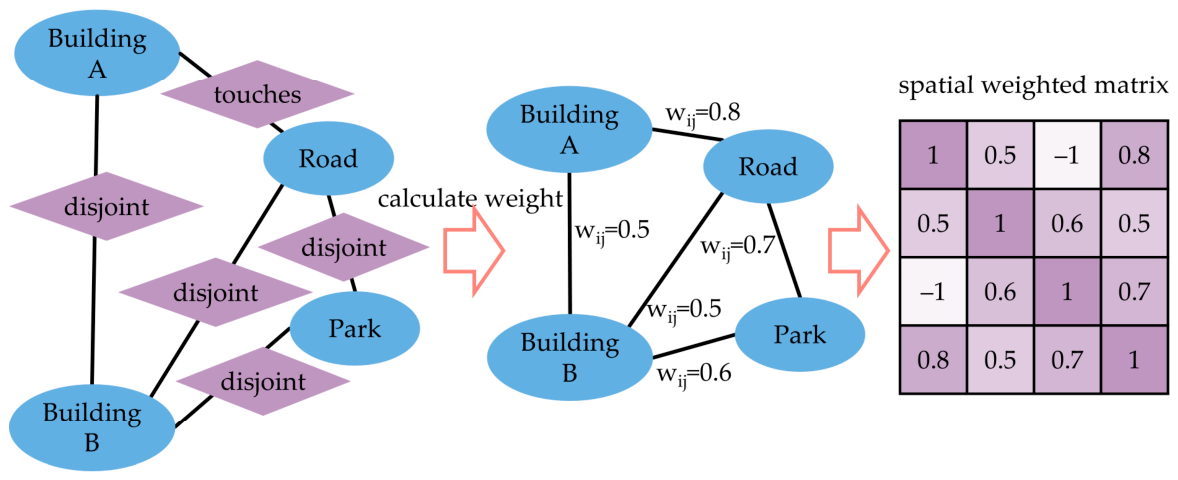
| touches | 0.8 | Two geometric objects share a boundary but do not intersect internally; they are adjacent |
| disjoint | 0.7 | Two geometric objects have no shared points; they are separate |
Appendix B
| Type | Query Task | Model Expressiveness |
|---|---|---|
| Simple query | Q1: Which park has name “Park an der Spree”? | All models return correct result. |
| Q2: Find all buildings of type “hospital”. | All models return correct results. | |
| Simple query | Q3: Which water is located in park “Oberseepark”? | All models return correct result (YAGO via predicate isLocatedIn; GeoKG via predicate isPartOf; HGeoKG via topological contains; MDSR-KG via topological contains). |
| Simple query | Q4: Which roads are adjacent to a given residential building? | All models return correct results (YAGO/GeoKG via isAdjacentTo; HGeoKG via Adjacent; MDSR-KG via topological touches). |
| Simple query | Q5: Retrieve the road network of “Ebertstraße”. | All models return correct results (31 road segments). |
| Simple query | Q6: Which administrative district a given building belongs to? | Only HGeoKG includes administrative hierarchy data; YAGO/GeoKG/MDSR-KG lack this data in the current experiment. |
| Simple query | Q7: What is the spatial relationship between park “Oberseepark” and kindergarten “Kitaverbund Regenbogen”? | YAGO returns “hasNeighbor”; GeoKG returns “near by” and HGeoKG return no result (disjoint not recorded); MDSR-KG returns “disjoint”. |
| Simple query | Q8: Which residential entities are within 100 m of the school called Manfred-Von-Ardenne Gymnasium? | Only MDSR-KG can execute (via distance attribute). YAGO/GeoKG/HGeoKG cannot represent metric constraints. |
| Simple query | Q9: Which roads are located south of water body “Papenpfuhlbecken”? | YAGO and HGeoKG cannot execute (no direction support); GeoKG returns correct results via “is south of”; MDSR-KG returns correct results via semantic south. |
| Simple query | Q10: What green areas inside park “Oberseepark”? | YAGO/GeoKG/HGeoKG cannot execute (no semantic tag for green area); MDSR-KG returns correct results via semantic attribute. |
| Complex query | Q11: Which hospital adjacent to commercial buildings? | All models return correct result (via adjacency predicates or touches topological attribute). |
| Complex query | Q12: Which commercial entities contain supermarket? | All models return correct results (via containment predicates or contain topological attribute). |
| Complex query | Q13: Which park contain both a lack and a forest? | All models return correct results (via containment predicates or contain topological attribute). |
| Complex query | Q14: Find parks located along a river and also having a fountain. | YAGO returns over-inclusive results (due to coarse category ‘BodyOfWater’); GeoKG and HGeoKG return correct result; MDSR-KG returns correct result. |
| Complex query | Q15: What lack is inside Tiergarten park within the Mitte district of Berlin? | Only HGeoKG includes administrative hierarchy data; YAGO/GeoKG/MDSR-KG lack this data in the current experiment. |
| Complex query | Q16: Find residential areas that are close to a main road and adjacent to a park. | YAGO returns partial results (using hasNeighbor as proxy); GeoKG and HGeoKG return fewer results (sparse relation instances); MDSR-KG returns all correct results (via combined topological and metric attributes). |
| Complex query | Q17: Which residential entities is within 50 m of school “John-Lennon-Gymnasium” and also near a park? | Only MDSR-KG can execute (metric constraint). YAGO/GeoKG/HGeoKG cannot represent distance. |
| Complex query | Q18: Which commercial entities are within 100 m of a river and is adjacent to a park? | Only MDSR-KG can execute (combined metric and topological constraint). YAGO/GeoKG/HGeoKG cannot represent metric constraints. |
| Complex query | Q19: Find the location of water towers located inside parks. | All models return correct result. |
| Complex query | Q20: Find names of all schools that have a kindergarten nearby. | YAGO returns over-inclusive results (due to coarse category ‘EducationalInstitution’); GeoKG and HGeoKG return correct results; MDSR-KG returns correct results. |
References
- Hou, Z.-W.; Liu, X.; Zhou, S.; Jing, W.; Yang, J. Bibliometric Analysis on the Research of Geoscience Knowledge Graph (GeoKG) from 2012 to 2023. ISPRS Int. J. Geo-Inf. 2024, 13, 255. [Google Scholar] [CrossRef]
- Ghazouani, F.; Farah, I.R.; Solaiman, B. A Multi-Level Semantic Scene Interpretation Strategy for Change Interpretation in Remote Sensing Imagery. IEEE Trans. Geosci. Remote Sens. 2019, 57, 8775–8795. [Google Scholar] [CrossRef]
- Phengsuwan, J.; Shah, T.; James, P.; Thakker, D.; Barr, S.; Ranjan, R. Ontology-Based Discovery of Time-Series Data Sources for Landslide Early Warning System. Computing 2020, 102, 745–763. [Google Scholar] [CrossRef]
- Potnis, A.V.; Durbha, S.S.; Shinde, R.C.; Talreja, P.V. Towards Visual Exploration of Semantically Enriched Remote Sensing Scene Knowledge Graphs (RSS-KGs). In Proceedings of the 2021 IEEE International Geoscience and Remote Sensing Symposium IGARSS, Brussels, Belgium; IEEE: New York, NY, USA, 2021; pp. 5783–5786. [Google Scholar]
- Zhang, J.; Gu, H.; Yang, Y.; Zhang, H.; Li, H. Research Progress and Trend of High-Resolution Remote Sensing Imagery Intelligent Interpretation. Natl. Remote Sens. Bull. 2021, 25, 2198–2210. [Google Scholar] [CrossRef]
- Hao, L.; Mei, X. Exploring the Use of Virtual Geographic Environments for Geo-Spatial Cognition Research. Natl. Remote Sens. Bull. 2021, 25, 2027–2039. [Google Scholar] [CrossRef]
- Montello, D.R. Cognition of Geographic Information. In A Research Agenda for Geographic Information Science; CRC Press: Boca Raton, FL, USA, 2004; pp. 61–91. [Google Scholar]
- Shoorcheh, M. On the Spatiality of Geographic Knowledge. Asian Geogr. 2019, 36, 63–80. [Google Scholar] [CrossRef]
- Nations, U. Transforming Our World: The 2030 Agenda for Sustainable Development. Available online: https://sdgs.un.org/2030agenda (accessed on 2 April 2026).
- Wang, S.; Han, W.; Zhang, X.; Li, J.; Wang, L. Geospatial Remote Sensing Interpretation: From Perception to Cognition. Innov. Geosci. 2024, 2, 100056. [Google Scholar] [CrossRef]
- Zheng, K.; Xie, M.H.; Zhang, J.B.; Xie, J.; Xia, S.H. A Knowledge Representation Model Based on the Geographic Spatiotemporal Process. Int. J. Geogr. Inf. Sci. 2022, 36, 674–691. [Google Scholar] [CrossRef]
- Ma, X.; Ma, C.; Wang, C. A New Structure for Representing and Tracking Version Information in a Deep Time Knowledge Graph. Comput. Geosci. 2020, 145, 104620. [Google Scholar] [CrossRef]
- Ma, X. Knowledge Graph Construction and Application in Geosciences: A Review. Comput. Geosci. 2022, 161, 105082. [Google Scholar] [CrossRef]
- Janowicz, K.; Hitzler, P.; Li, W.; Rehberger, D.; Schildhauer, M.; Zhu, R.; Shimizu, C.; Fisher, C.; Cai, L.; Mai, G. Know, Know Where, KnowWhereGraph: A Densely Connected, Cross-Domain Knowledge Graph and Geo-Enrichment Service Stack for Applications in Environmental Intelligence. AI Mag. 2022, 43, 30–39. [Google Scholar] [CrossRef]
- Géraldine, D.M.; Peng, P.; Jérôme, G.; Christophe, C.; Feng, L. Leveraging Spatio-Temporal Graphs and Knowledge Graphs: Perspectives in the Field of Maritime Transportation. ISPRS Int. J. Geo-Inf. 2021, 8, 541. [Google Scholar] [CrossRef]
- Shbita, B.; Knoblock, C.A.; Duan, W.; Chiang, Y.Y.; Uhl, J.H.; Leyk, S. Building Spatio-Temporal Knowledge Graphs from Vectorized Topographic Historical Maps. Semant. Web 2023, 14, 527–549. [Google Scholar] [CrossRef]
- Qiu, P.; Jialiang, G.; Li, Y.; Feng, L. Knowledge Embedding with Geospatial Distance Restriction for Geographic Knowledge Graph Completion. ISPRS Int. J. Geo-Inf. 2019, 6, 254. [Google Scholar] [CrossRef]
- Cui, W.; Yao, M.; Hao, Y.; Wang, Z.; He, X.; Wu, W.; Li, J.; Zhao, H.; Xia, C.; Wang, J. Knowledge and Geo-Object Based Graph Convolutional Network for Remote Sensing Semantic Segmentation. Sensors 2021, 21, 3848. [Google Scholar] [CrossRef] [PubMed]
- Liu, D. Study construction of the geo-entities database—Major in rivers. Master’s Thesis, Shandong University of Science and Technology, Qingdao, China, 2010. [Google Scholar]
- Yue, Z.; Zhong, S.; Mei, X. Research on Complex Spatiotemporal Semantic Modeling Integrating Spatial Data Engines and Graph Databases. J. Geo-Inf. Sci. 2025, 27, 1289–1304. [Google Scholar]
- Suchanek, F.M.; Alam, M.; Bonald, T.; Chen, L.; Paris, P.-H.; Soria, J. Yago 4.5: A Large and Clean Knowledge Base with a Rich Taxonomy. In Proceedings of the 47th International ACM SIGIR Conference on Research and Development in Information Retrieval, Washington, DC, USA; Association for Computing Machinery: New York, NY, USA, 2024; pp. 131–140. [Google Scholar]
- Lehmann, J.; Isele, R.; Jakob, M.; Jentzsch, A.; Kontokostas, D.; Mendes, P.N.; Hellmann, S.; Morsey, M.; Van Kleef, P.; Auer, S. Dbpedia–a Large-scale, Multilingual Knowledge Base Extracted from Wikipedia. Semant. Web 2015, 6, 167–195. [Google Scholar] [CrossRef]
- Ning, Y.; Liu, H. UrbanKGent: A Unified Large Language Model Agent Framework for Urban Knowledge Graph Construction. In Proceedings of the NeurIPS 2024, Annual Conference on Neural Information Processing Systems 37, Vancouver, Canada; Curran Associates, Inc.: New York, NY, USA, 2024. [Google Scholar]
- Hu, L.; Li, W.; Xu, J.; Zhu, Y. GeoEntity-Type Constrained Knowledge Graph Embedding for Predicting Natural-Language Spatial Relations. Int. J. Geogr. Inf. Sci. 2025, 39, 376–399. [Google Scholar] [CrossRef]
- Guo, C.; Xu, T.; Liu, L. Construction of Knowledge Graph Based on Geographic Ontology. In Proceedings of the IOP Conference Series: Earth and Environmental Science; IOP Publishing: Philadelphia, PA, USA, 2019; p. 052161. [Google Scholar]
- Du, J.; Wang, S.; Ye, X.; Sinton, D.S.; Kemp, K. GIS-KG: Building a Large-Scale Hierarchical Knowledge Graph for Geographic Information Science. Int. J. Geogr. Inf. Sci. 2022, 36, 873–897. [Google Scholar] [CrossRef]
- Zhang, B.; Yin, C.; Liu, K.; Zhai, X.; Sun, Y.; Du, M. Research on the Construction of Geographic Knowledge Graph Integrating Natural Disaster Information. ISPRS Ann. Photogramm. Remote Sens. Spat. Inf. Sci. 2022, 10, 79–85. [Google Scholar] [CrossRef]
- Lovera, F.; Cardinale, Y.; Buscaldi, D.; Charnois, T. A Knowledge Graph-Based Method for the Geolocation of Tweets. In Proceedings of the Workshop Proceedings of the 19th International Conference on Intelligent Environments (IE2023); IOS Press: Amsterdam, The Netherlands, 2023; pp. 53–62. [Google Scholar]
- Liu, X.; Xiao, Y.; Zhou, S. Knowledge-Graph-Driven Environmental Monitoring with Cross-Regions Knowledge Transfer. Knowl. Inf. Syst. 2025, 67, 2721–2744. [Google Scholar] [CrossRef]
- Clementini, E. A Conceptual Framework for Modelling Spatial Relations. Inf. Technol. Control 2019, 48, 5–17. [Google Scholar] [CrossRef]
- Cao, J.; Fang, J.; Meng, Z.; Liang, S. Knowledge Graph Embedding: A Survey from the Perspective of Representation Spaces. ACM Comput. Surv. 2024, 56, 1–42. [Google Scholar] [CrossRef]
- Yang, H.; Zhang, J.; Luo, Y.; Wang, L. Representation Learning on Knowledge Graph: A Path Attention-Based Method. Wirel. Netw. 2025, 32, 15–30. [Google Scholar] [CrossRef]
- Auer, S.; Lehmann, J.; Hellmann, S. Linkedgeodata: Adding a Spatial Dimension to the Web of Data. In Proceedings of the The Semantic Web-ISWC 2009: 8th International Semantic Web Conference, Chantilly, VA, USA; Springer: Berlin/Heidelberg, Germany, 2009; pp. 731–746. [Google Scholar]
- Chen, J.; Deng, S.; Chen, H. Crowdgeokg: Crowdsourced Geo-Knowledge Graph. In Proceedings of the Knowledge Graph and Semantic Computing. Language, Knowledge, and Intelligence: Second China Conference, CCKS 2017, Chengdu, China; Springer: Berlin/Heidelberg, Germany, 2017; pp. 165–172. [Google Scholar]
- Dsouza, A.; Tempelmeier, N.; Yu, R.; Gottschalk, S.; Demidova, E. Worldkg: A World-Scale Geographic Knowledge Graph. In Proceedings of the 30th ACM International Conference on Information & Knowledge Management; Association for Computing Machinery: New York, NY, USA, 2021; pp. 4475–4484. [Google Scholar]
- Wang, S.; Zhang, X.; Ye, P.; Du, M.; Lu, Y.; Xue, H. Geographic Knowledge Graph (GeoKG): A Formalized Geographic Knowledge Representation. ISPRS Int. J. Geo-Inf. 2019, 8, 184. [Google Scholar] [CrossRef]
- Han, B.; Qu, T.; Tong, X.; Wang, H.; Liu, H.; Huo, Y.; Cheng, C. AugGKG: A Grid-Augmented Geographic Knowledge Graph Representation and Spatio-Temporal Query Model. Int. J. Digit. Earth 2023, 16, 4934–4957. [Google Scholar] [CrossRef]
- Li, T.; Chen, R.; Duan, Y.; Yao, H.; Li, S.; Li, X. HGeoKG: A Hierarchical Geographic Knowledge Graph for Geographic Knowledge Reasoning. ISPRS Int. J. Geo-Inf. 2025, 14, 18. [Google Scholar] [CrossRef]
- Hu, L.; Li, W.; Zhu, Y. Geometric Feature Enhanced Knowledge Graph Embedding and Spatial Reasoning. In Proceedings of the 7th ACM SIGSPATIAL International Workshop on AI for Geographic Knowledge Discovery; Association for Computing Machinery: New York, NY, USA, 2024; pp. 50–53. [Google Scholar]
- Yang, Y.; Kong, D.; Cao, M.; Chen, M. GEUKE: A Geographic Entities Uniformly Explicit Knowledge Embedding Model. Trans. GIS 2024, 28, 1313–1325. [Google Scholar] [CrossRef]
- Hamzei, E.; Winter, S.; Tomko, M. Templates of Generic Geographic Information for Answering Where-Questions. Int. J. Geogr. Inf. Sci. 2022, 36, 188–214. [Google Scholar] [CrossRef]
- Zhang, J.; Chen, R.; Li, S.; Li, T.; Yao, H. MGKGR: Multimodal Semantic Fusion for Geographic Knowledge Graph Representation. Algorithms 2024, 17, 593. [Google Scholar] [CrossRef]
- OGC 06-103r4; Ogc Simple Features Access—Part 1: Common Architecture. Open Geospatial Consortium (OGC): Wayland, MA, USA, 2011.
- Hogan, A.; Blomqvist, E.; Cochez, M.; d’Amato, C.; Melo, G.D.; Gutierrez, C.; Kirrane, S.; Gayo, J.E.L.; Navigli, R.; Neumaier, S. Knowledge Graphs. ACM Comput. Surv. 2021, 54, 1–37. [Google Scholar] [CrossRef]
- ISO 19107:2019; Geographic Information—Spatial Schema. International Organization for Standardization: Geneva, Switzerland, 2019.
- Leemhuis, M.; Özçep, Ö.L.; Wolter, D. Knowledge Graph Embeddings with Ontologies: Reification for Representing Arbitrary Relations. In Proceedings of the German Conference on Artificial Intelligence (Künstliche Intelligenz); Springer: Berlin/Heidelberg, Germany, 2022; pp. 146–159. [Google Scholar]
- Benelhaj-Sghaier, S.; Gillet, A.; Leclercq, É. Knowledge Graph Multilevel Abstraction: A Property Graph Reification Based Approach. In Proceedings of the International Conference on Research Challenges in Information Science; Springer: Berlin/Heidelberg, Germany, 2024; pp. 12–19. [Google Scholar]
- Miller, H. Tobler’s First Law and Spatial Analysis. Ann. Assoc. Am. Geogr. 2004, 94, 284–289. [Google Scholar] [CrossRef]
- Janatabadi, F.; Ermagun, A. Access Weight Matrix: A Place and Mobility Infused Spatial Weight Matrix. Geogr. Anal. 2024, 56, 746–767. [Google Scholar] [CrossRef]
- Kubara, M.; Kopczewska, K. Akaike Information Criterion in Choosing the Optimal K-Nearest Neighbours of the Spatial Weight Matrix. Spat. Econ. Anal. 2024, 19, 73–91. [Google Scholar] [CrossRef]
- Chen, Z.; Yang, Y. A Case of Establishment and Application of Spatial Correlation Degree Algorithm for Geographic Entities Coupling Scales. J. Geo-Inf. Sci. 2018, 20, 37–47. [Google Scholar] [CrossRef]
- Dentinho, T.P.; Rodrigues, A.F. Conceptual and Operational Models of Complex Spatial Interaction. In Handbook on Entropy, Complexity and Spatial Dynamics; Edward Elgar Publishing: Northampton, MA, USA, 2021; pp. 510–537. [Google Scholar]
- Silveira, P.; Dentinho, T.P. Land Use Simulation Models. In Spatial Interaction Models with Land Use: A Tool for Interdisciplinary Analysis and Integrated Territorial Policy; Springer: Berlin/Heidelberg, Germany, 2024; pp. 7–47. [Google Scholar]
- Kellerman, A. Social-Spatial Interaction, Proximity, and Distance: From Face-to-Face to Virtual Communications. Appl. Mobilities 2022, 7, 394–412. [Google Scholar] [CrossRef]
- Wang, S.; Yang, C.; Li, Z.J.L. Spatio-Temporal Evolution Characteristics and Spatial Interaction Spillover Effects of New-Urbanization and Green Land Utilization Efficiency. Land 2021, 10, 1105. [Google Scholar] [CrossRef]
- Sung, C.L.; Tuo, R. A Review on Computer Model Calibration. Wiley Interdiscip. Rev. Comput. Stat. 2024, 16, e1645. [Google Scholar] [CrossRef]
- Sylvia, V.; Lydia, M.S.; Nasution, B.B. Improving SVM Performance in Determining Cost and Kernel Parameter Values Through Grid Search. In Proceedings of the 2024 2nd International Conference on Technology Innovation and Its Applications (ICTIIA), Medan, Indonesia; IEEE: New York, NY, USA, 2024; pp. 1–6. [Google Scholar]
- Gualtieri, L.; Fraboni, F.; Brendel, H.; Pietrantoni, L.; Vidoni, R.; Dallasega, P. Updating Design Guidelines for Cognitive Ergonomics in Human-Centred Collaborative Robotics Applications: An Expert Survey. Appl. Ergon. 2024, 117, 104246. [Google Scholar] [CrossRef]
- Montello, D.R.; Fabrikant, S.I.; Ruocco, M.; Middleton, R.S. Testing the First Law of Cognitive Geography on Point-Display Spatializations. In Proceedings of the International Conference on Spatial Information Theory; Springer: Berlin/Heidelberg, Germany, 2003; pp. 316–331. [Google Scholar]
- Shams, M.Y.; Elshewey, A.M.; El-Kenawy, E.-S.M.; Ibrahim, A.; Talaat, F.M.; Tarek, Z. Water Quality Prediction Using Machine Learning Models Based on Grid Search Method. Multimed. Tools Appl. 2024, 83, 35307–35334. [Google Scholar] [CrossRef]
- Bocianowski, J.; Wrońska-Pilarek, D.; Krysztofiak-Kaniewska, A.; Matusiak, K.; Wiatrowska, B. Comparison of Pearson’s and Spearman’s Correlation Coefficients for Selected Traits of Pinus sylvestris L. Biom. Lett. 2024, 61, 115–135. [Google Scholar] [CrossRef]
- Yu, H.; Hutson, A.D.J.C.i.S.-T. A Robust Spearman Correlation Coefficient Permutation Test. Commun. Stat.-Theory Methods 2024, 53, 2141–2153. [Google Scholar] [CrossRef]
- Dai, H.; Liu, Y.; Guadagnini, A.; Yuan, S.; Yang, J.; Ye, M. Comparative Assessment of Two Global Sensitivity Approaches Considering Model and Parameter Uncertainty. Water Resour. Res. 2024, 60, e2023WR036096. [Google Scholar] [CrossRef]
- Hamby, D.M. A Review of Techniques for Parameter Sensitivity Analysis of Environmental Models. Environ. Monit. Assess. 1994, 32, 135–154. [Google Scholar] [CrossRef] [PubMed]
- Biljecki, F.; Chow, Y.S.; Lee, K. Quality of Crowdsourced Geospatial Building Information: A Global Assessment of OpenStreetMap Attributes. Build. Environ. 2023, 237, 110295. [Google Scholar] [CrossRef]
- Huang, H.; Dong, Z. Research on Architecture and Query Performance Based on Distributed Graph Database Neo4j. In Proceedings of the 2013 3rd International Conference on Consumer Electronics, Communications and Networks, Xianning, China; IEEE: New York, NY, USA, 2013; pp. 533–536. [Google Scholar]
- Zhang, X.; Eldawy, A. Spatial Query Optimization with Learning. In Proceedings of the VLDB Endowment; VLDB Endowment Inc.: Franklin County, OH, USA, 2024; pp. 4245–4248. [Google Scholar]
- Liu, H.; Sun, Y.; Wang, G. Continuous Spatial Keyword Query Processing over Geo-Textual Data Streams. World Wide Web 2023, 26, 889–903. [Google Scholar] [CrossRef]
- Lian, D.; Wu, Y.; Ge, Y.; Xie, X.; Chen, E. Geography-Aware Sequential Location Recommendation. In Proceedings of the 26th ACM SIGKDD International Conference on Knowledge Discovery & Data Mining; Association for Computing Machinery: New York, NY, USA, 2020; pp. 2009–2019. [Google Scholar]
- Wang, Z.; Zhu, Y.; Zhang, Q.; Liu, H.; Wang, C.; Liu, T. Graph-Enhanced Spatial-Temporal Network for Next Poi Recommendation. ACM Trans. Knowl. Discov. Data 2022, 16, 1–21. [Google Scholar] [CrossRef]
- Liu, Y.; Wei, W.; Sun, A.; Miao, C. Exploiting Geographical Neighborhood Characteristics for Location Recommendation. In Proceedings of the 23rd ACM International Conference on Conference on Information and Knowledge Management; Association for Computing Machinery: New York, NY, USA, 2014; pp. 739–748. [Google Scholar]
- Liu, J.; Chen, Y.; Huang, X.; Li, J.; Min, G. GNN-Based Long and Short Term Preference Modeling for Next-Location Prediction. Inf. Sci. 2023, 629, 1–14. [Google Scholar] [CrossRef]
- Walker, B.B.; Schuurman, N.; Swanlund, D.; Clague, J.J. GIS-Based Multicriteria Evaluation for Earthquake Response: A Case Study of Expert Opinion in Vancouver, Canada. Nat. Hazards 2021, 105, 2075–2091. [Google Scholar] [CrossRef]
- Zhai, J.; Jin, Y.; Chen, W.; Zheng, W. Graph Analysis for Scalability Analysis. In Performance Analysis of Parallel Applications for HPC; Springer: Berlin/Heidelberg, Germany, 2023; pp. 101–128. [Google Scholar]
- Vilaça, R.; Cruz, F.; Oliveira, R. On the Expressiveness and Trade-Offs of Large Scale Tuple Stores. In Proceedings of the OTM Confederated International Conferences “On the Move to Meaningful Internet Systems”; Springer: Berlin/Heidelberg, Germany, 2010; pp. 727–744. [Google Scholar]
- Amekoe, K.M.; Azzag, H.; Dagdia, Z.C.; Lebbah, M.; Jaffre, G. Exploring Accuracy and Interpretability Trade-Off in Tabular Learning with Novel Attention-Based Models. Neural Comput. Appl. 2024, 36, 18583–18611. [Google Scholar] [CrossRef]
- Bi, X.; Yue, J.; Chen, Z. Lightweight Text-Vqa: Superior Trade-Off Between Performance and Capacity. Expert Syst. Appl. 2025, 270, 126478. [Google Scholar] [CrossRef]




| Attribute | Landuse | Water | Roads | Railways | Pois |
|---|---|---|---|---|---|
| Shape | Polygon | Polygon | Polyline | Polyline | Polygon |
| osm_id | 4592869 | 4317997 | 4045243 | 4381161 | 4637750 |
| code | 7202 | 8200 | 5113 | 6102 | 2110 |
| fclass | park | water | primary | light_rail | hospital |
| name | Ottopark | Schlachtensee | Frankfurter Allee | Berliner Stadtbahn | DRK Kliniken Berlin Mitte |
| ref | / | / | B1; B5 | / | / |
| oneway | / | / | F | / | / |
| maxspeed | / | / | 50 | / | / |
| layer | / | / | 0 | 1 | / |
| bridge | / | / | F | T | / |
| tunnel | / | / | F | F | / |
| Models | Semantic Query | Topology Query | Metric Query | Composites Query | Supported Count |
|---|---|---|---|---|---|
| YAGO | ✓ (limited predicates) | ✗ | ✗ | ✗ | 1 |
| GeoKG | ✓ | ✓ (limited predicates) | ✗ | ✗ | 2 |
| HGeoKG | ✓ (entity attributes) | ✓ | ✗ | ✗ | 2 |
| MDSR-KG | ✓ | ✓ | ✓ | ✓ | 4 |
| Models | F1 Score | Explanation |
|---|---|---|
| YAGO | 0.83 | Semantic predicates approximate topology (e.g., ‘hasNeighbor’ for ‘disjoint’); coarse categories cause over-inclusion |
| GeoKG | 0.89 | Missing ‘disjoint’ relations; sparse relation instances reduce recall |
| HGeoKG | 0.89 | Missing ‘disjoint’ relations; sparse relation instances |
| MDSR-KG | 0.99 | Multidimensional attributes ensure precise matching |
| Type | Query Task | YAGO | GeoKG | HGeoKG | MDSR-KG | Correct Answer |
|---|---|---|---|---|---|---|
| Simple query | Q_A: Which residential entities are within 100 m of the school called Manfred-Von-Ardenne Gymnasium? | Cannot execute. No distance metric support. | Cannot execute. No distance metric support. | Cannot execute. No distance metric support. | Returns all 8 entities via distance attribute (dij ≤ 100 m). | 8 entities (OSM IDs: 1231750611, 1231750614, 1231750615, 1231750617, 1231754163, 1231754164, 46931506, 46931556) |
| Simple query | Q_B: What is the spatial relationship between park “Oberseepark” and kindergarten “Kitaverbund Regenbogen”? | Returns “hasNeighbor”. | Returns “near by”. | No result. HGeoKG does not record disjoint relations. | Returns “disjoint” via topological attribute. | disjoint |
| Complex query | Q_C: Which commercial entities are within 100 m of a river and are adjacent to a park? | Cannot execute. Cannot represent metric constraint. | Cannot execute. Cannot represent metric constraint. | Cannot execute. Cannot represent metric constraint. | Returns the correct entity via combined filtering on distance (d_ij ≤ 100 m) and topology (touches). | 1 entity (OSM ID: 419912417) |
| Task Type | Task |
|---|---|
| influence ranking | A1 (Ecological Influence): Identify the three water bodies with the greatest environmental influence on the park “Volkspark Friedrichshain”. |
| A2 (Traffic Influence): Identify the three roads most critical to the traffic accessibility of the major commercial facility (OSM ID: 138554287). | |
| A3 (Service Influence): Identify the three commercial facilities that provide the most essential services to the residential area (OSM ID: 47722627). | |
| suitability recommendation | B1 (Emergency Facility Siting): Recommend three optimal locations for a new fire station to enable the fastest response to multiple high-density residential areas. |
| B2 (Commercial Facility Siting): Recommend three optimal locations for a new large supermarket, ensuring proximity to residential areas and convenient truck access (close to major roads). | |
| B3 (Public Space Siting): Recommend three optimal locations for a new community park, ensuring service to multiple residential areas while maintaining a quiet environment (away from major roads). |
| Task | Results of MDSR-KG (OSM ID, Type, Name) | Results of Expert (Reference) (OSM ID, Type, Name) | Expert Ratings (E1,E2,E3) * | Mean Score |
|---|---|---|---|---|
| A1 | 1. (53477, water, null) 2. (1628978, water, null) 3. (53487, water, null) | 1. (26993, water, Neuer See) 2. (53477, water, null) 3. (1628978, water, null) | (4,4,3) | 3.67 |
| A2 | 1. (1132163645, tertiary, Friedrichstrae) 2. (387125525, subway, U6) 3. (753316505, tertiary, Glinkastrae) | 1. (387125525, subway, U6) 2. (1132163645, tertiary, Friedrichstrae) 3. (753316505, tertiary, Glinkastrae) | (5,5,5) | 5.0 |
| A3 | 1. (478632893, commercial, null) 2. (478633215, commercial, null) 3. (18630167, commercial, null) | 1. (478632893, commercial, null) 2. (18630167, commercial, null) 3. (478632299, commercial, null) | (4,4,4) | 4.0 |
| B1 | 1. (1305456605, residential, null) 2. (1305456602, residential, null) 3. (1305456606, residential, null) | 1. (1305456605, residential, null) 2. (1305456606, residential, null) 3. (1305506226, residential, null) | (4,4,3) | 3.67 |
| B2 | 1. (25807904, commercial, MEON-Gewerbepark) 2. (1064294301, commercial, null) 3. (1077364415, commercial, null) | 1. (25807904, commercial, MEON-Gewerbepark) 2. (1064294301, commercial, null) 3. (1077364415, commercial, null) | (5,5,5) | 5.0 |
| B3 | 1. (1295122233, residential, null) 2. (1295300270, residential, null) 3. (1295257439, residential, null) | 1. (1295300270, residential, null) 2. (1295122239, residential, null) 3. (1295122240, residential, null) | (3,3,3) | 3.0 |
| Overall mean | 4.06 | |||
| Model | Nodes Count | Edges Count | Construction Time (s) | Average Query Response Time (ms) | Total Execution Time (s) | Throughput (Queries/s) |
|---|---|---|---|---|---|---|
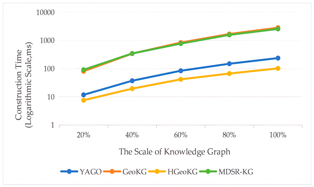
| MDSR-KG | 18,166,522 | 36,216,652 | 2592.02 | 49.41 | 8.85 | 3.38 |
| HGeoKG | 58,205 | 258,837 | 102.61 | 4.05 | 1.20 | 24.91 |
| GeoKG | 174,588 | 18,224,718 | 2859.45 | 48.19 | 22.08 | 1.35 |
| YAGO | 58,196 | 2,068,143 | 238.49 | 40.21 | 7.82 | 3.83 |
Disclaimer/Publisher’s Note: The statements, opinions and data contained in all publications are solely those of the individual author(s) and contributor(s) and not of MDPI and/or the editor(s). MDPI and/or the editor(s) disclaim responsibility for any injury to people or property resulting from any ideas, methods, instructions or products referred to in the content. |
© 2026 by the authors. Published by MDPI on behalf of the International Society for Photogrammetry and Remote Sensing. Licensee MDPI, Basel, Switzerland. This article is an open access article distributed under the terms and conditions of the Creative Commons Attribution (CC BY) license.
Share and Cite
Chen, Y.; Zhang, J.; Ge, J.; Peng, Z. MDSR-KG: A Geographical Knowledge Graph Framework for Representing and Quantifying Spatial Relationships. ISPRS Int. J. Geo-Inf. 2026, 15, 236. https://doi.org/10.3390/ijgi15060236
Chen Y, Zhang J, Ge J, Peng Z. MDSR-KG: A Geographical Knowledge Graph Framework for Representing and Quantifying Spatial Relationships. ISPRS International Journal of Geo-Information. 2026; 15(6):236. https://doi.org/10.3390/ijgi15060236
Chicago/Turabian StyleChen, Ying, Jixian Zhang, Juan Ge, and Zhanji Peng. 2026. "MDSR-KG: A Geographical Knowledge Graph Framework for Representing and Quantifying Spatial Relationships" ISPRS International Journal of Geo-Information 15, no. 6: 236. https://doi.org/10.3390/ijgi15060236
APA StyleChen, Y., Zhang, J., Ge, J., & Peng, Z. (2026). MDSR-KG: A Geographical Knowledge Graph Framework for Representing and Quantifying Spatial Relationships. ISPRS International Journal of Geo-Information, 15(6), 236. https://doi.org/10.3390/ijgi15060236