




Visualisation Methodology for Informed Decision-Making Applied to Smart City and Digital Twin Contexts



Abstract
1. Introduction
2. Materials and Methods
2.1. Case Selection Process and Representativeness
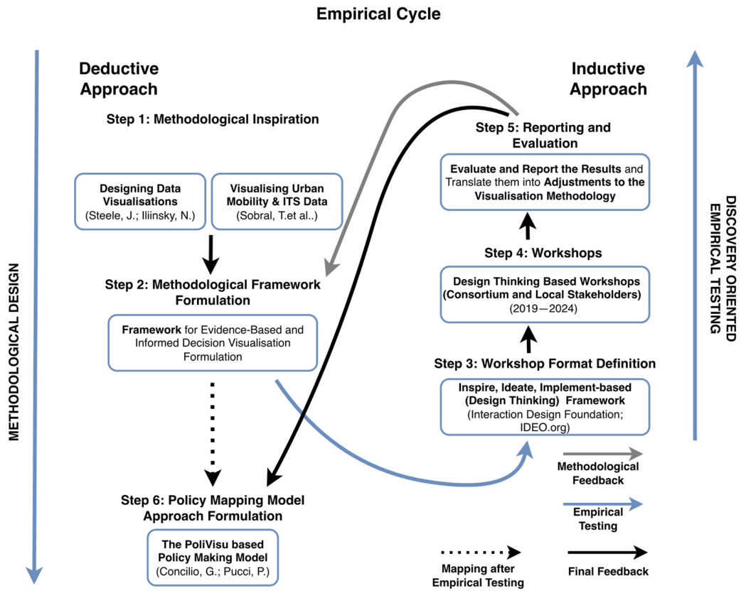
2.2. Towards a Visualisation Methodology
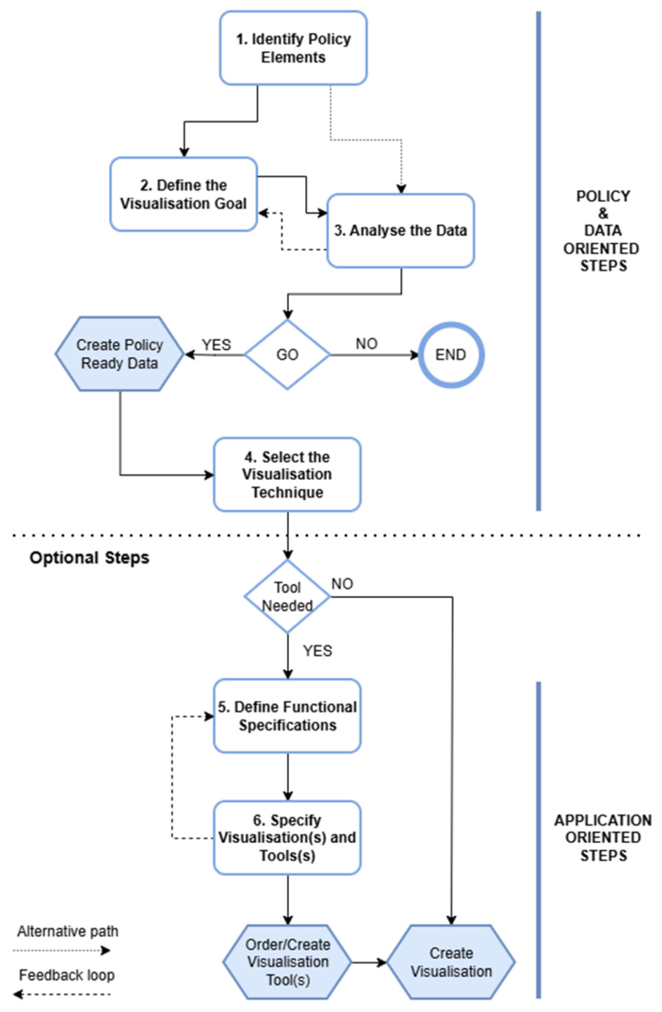
2.3. Stepwise Methodological Approach
- What information needs to be conveyed through the visualisation?
- What relationships between different elements should the visualisation communicate?
- What data dimensions and values are pertinent to the context of the visualisation?
- What actions will be taken based on the information conveyed by the visualisation?
- Is the intent of the visualisation to inform or persuade?
- Who is the intended audience of the visualisation (e.g., experts, policymakers, the general public)?
- Is the visualisation language consistent with the subject matter and reference framework?
- What data is necessary to achieve the visualisation objectives?
- What data is available?
- What is the data structure and format?
- What are the indispensable data fields and dimensions to visualise?
- How reliable and complete is the data source?
- Is there sufficient data provenance (regularly updated versions, reliable metadata)?
- Are there other relevant data sources that could be utilised?
- Can the data be used legally and ethically?
- Availability of tools that support the visualisation demand;
- The time and scope (need for a quick one-time visualisation or recurring visualisation over a longer term);
- If it concerns a strategic expansion of an existing toolset;
- Relevance to multiple policy domains;
- If it concerns the development of a strategic (visualisation/policy) tool with a broader scope (e.g., for external communication and participation);
- The total and relative costs of alternative solutions.
2.4. Application in a Policy-Making Context
3. Results
3.1. Pilot Cases
3.2. Smart City-Related Visualisation Techniques
3.2.1. Dashboard Visualisations
- Visualisation Dashboard
- Policy Dashboard
3.2.2. Intensity Map Visualisations
3.2.3. Algorithm Visualisations
3.2.4. Digital Twin Visualisations
3.2.5. Visualisation, Data and Tool Assessment
3.3. Use in the Policy-Making Cycle
4. Discussion
4.1. Applicability of the Visualisation Methodology in a Smart City Context
4.2. Applicability of the Visualisation Methodology in the Policy-Making Cycle
4.3. Policy-Ready Data and Evidence-Informed Decision-Making
4.4. Visualising Complexity
4.5. Privacy and Ethics
4.6. Limits and Replicability
5. Conclusions
Author Contributions
Funding
Data Availability Statement
Conflicts of Interest
Appendix A

| Criterion 1 AIM: Visualisation of Big Data Within an Urban or Regional Policy Context (1) | Criterion 2 At Least One Smart-City Related Domain is Involved (2) | Criterion 3 Domain and Policy Experts Participated Throughout the Entire Process (3) | Criterion 4 Evaluation of the Applicability in the Policy Cycle (4) | Evaluation (in Case Some Criteria Aren’t Met) | |
|---|---|---|---|---|---|
| Athens (GR)—Air Quality awareness creation amongst vulnerable people | V | V | The citizen initiative was not translated into policy actions (no follow-up by experts during the EU project). | ||
| Athens (GR)—Digital Twin, Green squares planning | V | V | V | V | |
| Athens (GR)—Digital Twin, Traffic load & creation of a pedestrian and cycling route | V | V | V | - | The applicability in a policy context couldn’t be tested because of the limited involvement of policy experts. |
| Berlin (DE)—Kiezblocks static air quality measuring campaign | V | V | V | - | The citizen initiative was not translated into policy actions. |
| Berlin (DE), Flanders (BE)—Dynamic exposure visualisation dashboard | V | V | V | V | |
| Czech Republic (CZ)—Covid-19 spread map | V | V | - | The Covid map was a demo to show the applicability of the software for a non-smart city visualisation (no follow-up by experts during the EU project). | |
| Flanders (BE)—Interactive road safety map | V | V | V | V | |
| Ghent (BE)—A data-driven approach towards the problem of illegal dumping of trash | - | V | Focus on the creation and visualisation of a (limited) point-based dataset and surrounding communication (no follow-up by experts during the EU project). | ||
| Ghent (BE)—Student displacements | V | V | V | V | |
| Herzele (BE)—Interactive schoolstreet dashboard | V | V | V | V | |
| Issy-Les-Moulinaux (FR)—Supporting Citizens for waste management | - | V | Focus on the creation and visualisation of a limited point-based dataset and surrounding communication actions (no follow-up by experts during the EU project). | ||
| Issy-les-Moulineaux (FR)—Traffic dashboard | V | V | V | V | |
| Issy-les-Moulineaux (FR)—Travel planning app | V | V | V | V | |
| Kortrijk (BE)—Use big data to detect parking behaviour | V | V | - | The pilot was set on hold during the process, with a lack of participation throughout the duration (no follow-up by experts during the EU project). | |
| Mechelen/Flanders (BE)—Impact of temporary road blocks (by road works) | V | V | V | - | The nature of the case is operational rather than strategic, hindering the applicability in the more strategic policy cycle. |
| Mechelen/Flanders (BE—Schoolstreet dashboard | V | V | V | V | |
| Pilsen (CZ)—Digital Twin, Ring road construction impact | V | V | V | V | |
| Pilsen (CZ)—Digital Twin, Solar equipment locations in the city park | V | V | V | V | |
| Pilsen (CZ)—Impact of roadworks simulation | V | V | V | V | |
| Pilsen (CZ)—Interactive road accident map | V | V | V | V | |
| Pilsen (CZ)—Interactive sensor based live and historic traffic map | V | V | V | V | |
| Pilsen (CZ)—Traffic measure impact modelling comparison | V | V | V | V | |
| Pilsen (CZ)—Traffic volume impact simulation modelling | V | V | V | V | |
| Pilsen (CZ), Ghent (BE)—Digital Twin, Impact of road closures | V | V | V | V | |
| Police zone Voorkempen (BE)—Trajectory speed limit enforcement dashboard | V | V | V | V | |
| Sint-Niklaas (BE)—Local mobility scheme/plan dashboard | V | V | V | V | |
| Sofia (BG)—Public Awareness campaign (air quality) | - | V | The case focuses on public media campaigns towards different target groups, with no big datasets or dashboards involved. | ||
| Sofia/Plovdiv—Implementing school bus services to kindergartens | - | - | There is no big dataset and policy visualisation involved. | ||
| Sofia/Plovdiv/Athens (BG/GR)—CO2 calculator | V | V | - | The CO2 calculator was used at the household level and wasn’t used by policy experts in any policy-making process. | |
| Solva region (BE)—Regional traffic behaviour | V | V | V | V | |
| The Netherlands (NL)—MoveSmarter | V | V | - | Was not part of the EU PoliVisu project itself, but used as a benchmark for the Ghent student displacements case (no follow-up by experts during the EU project). |
References
- Janssen, M.; Helbig, N. Innovating and Changing the Policy-Cycle: Policy-Makers Be Prepared! Gov. Inf. Q. 2018, 35, S99–S105. [Google Scholar] [CrossRef] [Scilit]
- Puron-Cid, G.; Gil-Garcia, J.; Luna-Reyes, L. Opportunities and Challenges of Policy Informatics. Int. J. Public Adm. Digit. Age 2016, 3, 66–85. [Google Scholar] [CrossRef] [Scilit]
- Ramaprasad, A.; Sánchez-Ortiz, A.; Syn, T. A Unified Definition of a Smart City. In Electronic Government; Lecture Notes in Computer Science; Springer: Cham, Switzerland, 2017; pp. 13–24. [Google Scholar]
- UNECE. Sustainable Smart Cities|UNECE. Available online: https://unece.org/housing/sustainable-smart-cities (accessed on 15 June 2025).
- Cabrera-Barona, P.F.; Merschdorf, H. A Conceptual Urban Quality Space-Place Framework: Linking Geo-Information and Quality of Life. Urban Sci. 2018, 2, 73. [Google Scholar] [CrossRef] [Scilit]
- Adam, C.; Steinebach, Y.; Knill, C. Neglected Challenges to Evidence-Based Policy-Making: The Problem of Policy Accumulation. Policy Sci. 2018, 51, 269–290. [Google Scholar] [CrossRef] [Scilit]
- Sackett, D.L.; Rosenberg, W.M.; Gray, J.M.; Haynes, R.B.; Richardson, W.S. Evidence Based Medicine: What It Is and What It Isn’t. BMJ 1996, 312, 71–72. [Google Scholar] [CrossRef] [Scilit] [PubMed]
- Nevo, I.; Slonim-Nevo, V. The Myth of Evidence-Based Practice: Towards Evidence-Informed Practice. Br. J. Soc. Work 2011, 41, 1176–1197. [Google Scholar] [CrossRef] [Scilit]
- Rubin, A. Improving the Teaching of Evidence-Based Practice: Introduction to the Special Issue. Res. Soc. Work Pract. 2007, 17, 541–547. [Google Scholar] [CrossRef] [Scilit]
- Kuhn, T.S.; Hacking, I. The Structure of Scientific Revolutions; University of Chicago Press: Chicago, IL, USA, 1970; Volume 2. [Google Scholar]
- Quine, W.V.O. Two Dogmas of Empiricism. In Perspectives in the Philosophy of Language; Broadview Press: Peterborough, ON, Canada, 2000; pp. 189–210. [Google Scholar]
- Sen, A. Rationality and Freedom; Harvard University Press: Cambridge, MA, USA, 2002. [Google Scholar]
- Chalmers, I. If Evidence-Informed Policy Works in Practice, Does It Matter If It Doesn’t Work in Theory? Evid. Policy 2005, 1, 227–242. [Google Scholar] [CrossRef] [Scilit]
- Epstein, I. Promoting Harmony Where There Is Commonly Conflict: Evidence-Informed Practice as an Integrative Strategy. Soc. Work Health Care 2009, 48, 216–231. [Google Scholar] [CrossRef] [Scilit]
- Head, B. Evidence-Based Policy-Making for Innovation. In Handbook of Innovation in Public Services; Edward Elgar Publishing: Cheltenham, UK, 2013; pp. 143–156. [Google Scholar] [CrossRef] [Scilit]
- Capano, G.; Lippi, A. How Policy Instruments Are Chosen: Patterns of Decision Makers’ Choices. Policy Sci. 2016, 50, 269–293. [Google Scholar] [CrossRef] [Scilit]
- Batty, M. Urban Informatics and Big Data. In Report ESRC Cities Expert Group; ESRC: Swindon, UK, 2013; pp. 1–36. [Google Scholar]
- Kitchin, R. Data-Driven Urbanism. In Data and the City; Routledge: London, UK, 2017; pp. 44–56. [Google Scholar]
- Kandt, J.; Batty, M. Smart Cities, Big Data and Urban Policy: Towards Urban Analytics for the Long Run. Cities 2021, 109, 102992. [Google Scholar] [CrossRef] [Scilit]
- Cepero Garcia, M.T.; Montane-Jimenez, L.G. Visualization to Support Decision-Making in Cities: Advances, Technology, Challenges, and Opportunities. In 2020 8th International Conference in Software Engineering Research and Innovation (CONISOFT); IEEE: Chetumal, Mexico, 2020; pp. 198–207. [Google Scholar] [CrossRef] [Scilit]
- Ruppert, T.; Dambruch, J.; Krämer, M.; Balke, T.; Gavanelli, M.; Bragaglia, S.; Chesani, F.; Milano, M.; Kohlhammer, J. Visual Decision Support for Policy Making: Advancing Policy Analysis with Visualization. In Policy Practice and Digital Science; Public Administration and Information Technology; Janssen, M., Wimmer, M.A., Deljoo, A., Eds.; Springer International Publishing: Cham, Switzerland, 2015; Volume 10, pp. 321–353. [Google Scholar] [CrossRef] [Scilit]
- Nash, K.; Trott, V.; Allen, W. The Politics of Data Visualisation and Policy Making. Converg. Int. J. Res. New Media Technol. 2022, 28, 3–12. [Google Scholar] [CrossRef] [Scilit]
- Lanza, G. Data-Related Ecosystems in Policy Making: The PoliVisu Contexts. In The Data Shake; SpringerBriefs in Applied Sciences and Technology; Concilio, G., Pucci, P., Raes, L., Mareels, G., Eds.; Springer International Publishing: Cham, Switzerland, 2021; pp. 91–104. [Google Scholar] [CrossRef] [Scilit]
- Kitchin, R.; Maalsen, S.; McArdle, G. The Praxis and Politics of Building Urban Dashboards. Geoforum 2016, 77, 93–101. [Google Scholar] [CrossRef] [Scilit]
- Piras, G.; Muzi, F.; Ziran, Z. Assessment of the Reliability of AI Models in Predicting Urban Energy Consumption Under Conditions of Small or Incomplete Data. Appl. Sci. 2026, 16, 1457. [Google Scholar] [CrossRef] [Scilit]
- Raineri, P.; Molinari, F. Innovation in Data Visualisation for Public Policy Making. In Data Shake; Springer International Publishin: Cham, Switzerland, 2021; pp. 47–59. [Google Scholar] [CrossRef] [Scilit]
- Mahoney, M. The Art and Science of Data Visualization. 2019. Available online: https://towardsdatascience.com/the-art-and-science-of-data-visualization-6f9d706d673e (accessed on 15 May 2026).
- Huang, H.; Yao, X.A.; Krisp, J.M.; Jiang, B. Analytics of Location-Based Big Data for Smart Cities: Opportunities, Challenges, and Future Directions. Comput. Environ. Urban Syst. 2021, 90, 101712. [Google Scholar] [CrossRef] [Scilit]
- European Environment Agency. Dos and Don’ts of Data Visualisation; European Environment Agency: Copenhagen, Denmark, 2021; Available online: https://www.eea.europa.eu/data-and-maps/daviz/learn-more/chart-dos-and-donts (accessed on 23 April 2024).
- Fritz, D. Auraria Library Research Guides Data Visualization. 2021. Available online: https://guides.auraria.edu/data_visualization/home (accessed on 23 April 2024).
- Klerkx, J.; Duval, E. Post-Academic Course Big Data—Module 3 Visualisation; KU Leuven, Gent University: Ghent, Belgium, 2015. [Google Scholar]
- Ge, L.W.; Easterday, M.; Kay, M.; Dimara, E.; Cheng, P.; Franconeri, S.L. V-FRAMER: Visualization Framework for Mitigating Reasoning Errors in Public Policy. In Proceedings of the CHI Conference on Human Factors in Computing Systems; ACM: Honolulu, HI, USA, 2024; pp. 1–15. [Google Scholar] [CrossRef] [Scilit]
- Raes, L. Informed Decision Making Visualisation Methodology Cases Research Data; Zenodo: Geneva, Switzerland, 2026. [Google Scholar] [CrossRef]
- European Parliament and Council. Regulation (EU) 2016/679 of the European Parliament and of the Council of 27 April 2016 on the Protection of Natural Persons with Regard to the Processing of Personal Data and on the Free Movement of Such Data, and Repealing Directive 95/46/EC (General Data Protection Regulation) (Text with EEA Relevance); European Parliament and Council: Brussels, Belgium, 2016; Available online: https://eur-lex.europa.eu/eli/reg/2016/679/oj (accessed on 3 March 2024).
- Bach, B.; Freeman, E.; Abdul-Rahman, A.; Turkay, C.; Khan, S.; Fan, Y.; Chen, M. Dashboard Design Patterns. IEEE Trans. Vis. Comput. Graph. 2022, 29, 342–352. [Google Scholar] [CrossRef] [Scilit] [PubMed]
- Yigitbasioglu, O.M.; Velcu, O. A Review of Dashboards in Performance Management: Implications for Design and Research. Int. J. Account. Inf. Syst. 2012, 13, 41–59. [Google Scholar] [CrossRef] [Scilit]
- Few, S. Information Dashboard Design: The Effective Visual Communication of Data, 1st ed.; O’Reilly Media: Santa Rosa, CA, USA, 2006. [Google Scholar]
- Jing, C.; Du, M.; Li, S.; Liu, S. Geospatial Dashboards for Monitoring Smart City Performance. Sustainability 2019, 11, 5648. [Google Scholar] [CrossRef] [Scilit]
- Badard, T.; Dubé, E. Enabling Geospatial Business Intelligence. Open Source Bus. Resour. 2009, 2009, 25–31. [Google Scholar]
- Grieves, M. SME Management Forum Completing the Cycle: Using PLM Information in the Sales and Service Functions. In SME Management Forum; SME Forum: South Orange, NJ, USA, 2002; Available online: https://www.researchgate.net/publication/356192963_SME_Management_Forum_Completing_the_Cycle_Using_PLM_Information_in_the_Sales_and_Service_Functions (accessed on 7 January 2026).
- Enders, M.R.; Hoßbach, N. Dimensions of Digital Twin Applications-a Literature Review. In AMCIS 2019 Proceedings; Organizational Transformation & Information Systems (SIGORSA): Atlanta, GA, USA, 2019. [Google Scholar]
- Mylonas, G.; Kalogeras, A.; Kalogeras, G.; Anagnostopoulos, C.; Alexakos, C.; Munoz, L. Digital Twins from Smart Manufacturing to Smart Cities: A Survey. IEEE Access 2021, 9, 143222–143249. [Google Scholar] [CrossRef] [Scilit]
- Deren, L.; Wenbo, Y.; Zhenfeng, S. Smart City Based on Digital Twins. Comput. Urban Sci. 2021, 1, 4. [Google Scholar] [CrossRef] [Scilit]
- Arcaute, E.; Barthelemy, M.; Batty, M. Future Cities: Why Digital Twins Need to Take Complexity Science on Board; University College LondonBartlett School of Environment Energy and Resources: London, UK, 2021. [Google Scholar]
- Shaofeng, L.; Zaraté, P.; Kamissoko, D.; Linden, I.; Papathanasiou, J. (Eds.) Decision Support Systems XIII. Decision Support Systems in An Uncertain World: The Contribution of Digital Twins. In 9th International Conference on Decision Support System Technology, ICDSST 2023, Albi, France, 30 May–1 June 2023; Lecture Notes in Business Information Processing; Springer: Cham, Switzerland, 2023; Volume 474. [Google Scholar] [CrossRef] [Scilit]
- Wang, B. The Seductive Smart City and the Benevolent Role of Transparency. Interact. Des. Archit. 2021, 48, 100–121. [Google Scholar] [CrossRef] [Scilit]
- Ricciardi, G.; Callegari, G. Digital Twins for Climate-Neutral and Resilient Cities. State of the Art and Future Development as Tools to Support Urban Decision-Making. In Urban Book Series; Springer: Cham, Switzerland, 2023; pp. 617–626. [Google Scholar] [CrossRef] [Scilit]
- Häkkilä, J.; Posti, M.; Koskenranta, O.; Ventä-Olkkonen, L. Co-Creating a Digital 3D City with Children. In Proceedings of the 12th International Conference on Mobile and Ubiquitous Multimedia; MUM’13; Association for Computing Machinery: New York, NY, USA, 2013. [Google Scholar] [CrossRef] [Scilit]
- Kim, J.; Kim, H.; Ham, Y. Mapping Local Vulnerabilities into a 3D City Model through Social Sensing and the CAVE System toward Digital Twin City; American Society of Civil Engineers: New York, NY, USA, 2019; pp. 451–458. [Google Scholar] [CrossRef] [Scilit]
- Riaz, K.; McAfee, M.; Gharbia, S.S. Management of Climate Resilience: Exploring the Potential of Digital Twin Technology, 3D City Modelling, and Early Warning Systems. Sensors 2023, 23, 2659. [Google Scholar] [CrossRef] [Scilit]
- Ruohomaki, T.; Airaksinen, E.; Huuska, P.; Kesaniemi, O.; Martikka, M.; Suomisto, J. Smart City Platform Enabling Digital Twin. In 2018 International Conference on Intelligent Systems (IS); IEEE: Funchal, Portugal, 2018; pp. 155–161. [Google Scholar] [CrossRef] [Scilit]
- Yu, Q.; Shang, W.-L.; Chen, J.; Zhang, H. Web-Based Spatio-Temporal Data Visualization Technology for Urban Digital Twin. In Handbook of Mobility Data Mining; Elsevier: Amsterdam, The Netherlands, 2023; pp. 185–201. [Google Scholar] [CrossRef] [Scilit]
- Syed Abdul Rahman, S.A.F.; Abdul Maulud, K.N.; Ujang, U.; Wan Mohd Jaafar, W.S.; Shaharuddin, S.; Ab Rahman, A.A. The Digital Landscape of Smart Cities and Digital Twins: A Systematic Literature Review of Digital Terrain and 3D City Models in Enhancing Decision-Making. Sage Open 2024, 14, 21582440231220768. [Google Scholar] [CrossRef] [Scilit]
- Babelon, I.; Pánek, J.; Falco, E.; Kleinhans, R.; Charlton, J. Between Consultation and Collaboration: Self-Reported Objectives for 25 Web-Based Geoparticipation Projects in Urban Planning. ISPRS Int. J. Geo-Inf. 2021, 10, 783. [Google Scholar] [CrossRef] [Scilit]
- Kopackova, H.; Libalova, P. Smart City Concept as Socio-Technical System. In 2017 International Conference on Information and Digital Technologies (IDT); IEEE: Zilina, Slovakia, 2017; pp. 198–205. [Google Scholar] [CrossRef] [Scilit]
- Hasija, S.; Shen, Z.-J.M.; Teo, C.-P. Smart City Operations: Modeling Challenges and Opportunities. Manuf. Serv. Oper. Manag. 2020, 22, 203–213. [Google Scholar] [CrossRef] [Scilit]
- Raes, L.; McAleer, S.R. Introduction: Defining Local Digital Twins. In Decide Better; Raes, L., Ruston McAleer, S., Croket, I., Kogut, P., Brynskov, M., Lefever, S., Eds.; Springer Nature Switzerland: Cham, Switzerland, 2025; pp. 1–5. [Google Scholar] [CrossRef] [Scilit]
- Batty, M. Digital Twins. Environ. Plan. B Urban Anal. City Sci. 2018, 45, 817–820. [Google Scholar] [CrossRef] [Scilit]
- Dihan, S.; Akash, A.I.; Tasneem, Z.; Das, P.; Das, S.K.; Islam, R.; Islam, M.; Badal, F.R.; Ali, F.; Ahamed, H.; et al. Digital Twin: Data Exploration, Architecture, Implementation and Future. Heliyon 2024, 10, e26503. [Google Scholar] [CrossRef] [Scilit] [PubMed]
- Ammara, U.; Rasheed, K.; Mansoor, A.; Al-Fuqaha, A.; Qadir, J. Smart Cities from the Perspective of Systems. Systems 2022, 10, 77. [Google Scholar] [CrossRef] [Scilit]
- Venumuddala, V.R.; Prakash, A.; Chaudhuri, B. Governing Smart City IoT Interventions: A Complex Adaptive Systems Perspective. Digit. Gov. Res. Pract. 2024, 5, 1–24. [Google Scholar] [CrossRef] [Scilit]
- Ning, Z.; Jia, M.; Li, J. From Smart Cities to Digital Twin Cities: A GIS-Driven Review of Urban Refined Governance Models and Paradigm Transformation. Geogr. Res. Bulletin 2026, 5, 3–35. [Google Scholar] [CrossRef]
- European Commission. Policy Development based on Advanced Geospatial Data Analytics and Visualisation (PoliVisu); CORDIS: Brussels, Belgium, 2017; Available online: https://cordis.europa.eu/project/id/769608 (accessed on 15 May 2026).
- European Commission. Digital Urban European Twins for Smarter Decision Making (DUET); CORDIS: Brussels, Belgium, 2019; Available online: https://cordis.europa.eu/project/id/870697 (accessed on 15 May 2026).
- European Commission. Community Observation Measurement & Participation in AIR Science (COMPAIR); CORDIS: Brussels, Belgium, 2021; Available online: https://cordis.europa.eu/project/id/101036563 (accessed on 15 May 2026).
- Bellini, P.; Nesi, P.; Pantaleo, G. IoT-Enabled Smart Cities: A Review of Concepts, Frameworks and Key Technologies. Appl. Sci. 2022, 12, 1607. [Google Scholar] [CrossRef] [Scilit]
- Tampère, C.; Ortmann, P.; Jedlička, K.; Lohman, W.; Janssen, S. Future Ready Local Digital Twins and the Use of Predictive Simulations: The Case of Traffic and Traffic Impact Modelling. In Decide Better; Raes, L., Ruston McAleer, S., Croket, I., Kogut, P., Brynskov, M., Lefever, S., Eds.; Springer Nature Switzerland: Cham, Switzerland, 2025; pp. 203–230. [Google Scholar] [CrossRef] [Scilit]
- Borghys, K.; Van Der Graaf, S.; Walravens, N.; Van Compernolle, M. Multi-Stakeholder Innovation in Smart City Discourse: Quadruple Helix Thinking in the Age of “Platforms”. Front. Sustain. Cities 2020, 2, 5. [Google Scholar] [CrossRef] [Scilit]
- Batty, M.; Axhausen, K.W.; Giannotti, F.; Pozdnoukhov, A.; Bazzani, A.; Wachowicz, M.; Ouzounis, G.; Portugali, Y. Smart Cities of the Future. Eur. Phys. J. Spec. Top. 2012, 214, 481–518. [Google Scholar] [CrossRef] [Scilit]
- Degbelo, A.; Granell, C.; Trilles, S.; Bhattacharya, D.; Casteleyn, S.; Kray, C. Opening up Smart Cities: Citizen-Centric Challenges and Opportunities from GIScience. ISPRS Int. J. Geo-Inf. 2016, 5, 16. [Google Scholar] [CrossRef] [Scilit]
- Diebold, F.X. On the Origin(s) and Development of the Term “Big Data.”. SSRN Electron. J. 2012, 2–4. [Google Scholar] [CrossRef] [Scilit]
- Lom, M.; Pribyl, O. Smart City Model Based on Systems Theory. Int. J. Inf. Manag. 2021, 56, 102092. [Google Scholar] [CrossRef] [Scilit]
- Steele, J.; Iliinsky, N. Designing Data Visualizations; Van Duuren Media: Culemborg, The Netherlands, 2011. [Google Scholar]
- Sobral, T.; Galvão, T.; Borges, J. Visualization of Urban Mobility Data from Intelligent Transportation Systems. Sensors 2019, 19, 332. [Google Scholar] [CrossRef] [Scilit]
- Interaction Design Foundation. What is Design Thinking (DT)? Design Thinking (DT). Available online: https://www.interaction-design.org/literature/topics/design-thinking#inspire,_ideate,_implement_by_ideo-14 (accessed on 24 October 2024).
- IDEO.org. Design Thinking Defined. IDEO Design Thinking. Available online: https://designthinking.ideo.com/ (accessed on 24 October 2024).
- PoliVisu Consortium. D3.5 the PoliVisu Policy Making Model; D3.5; Politecnico Di Milano (DATSU): Milano, Italy, 2018; Available online: https://cordis.europa.eu/project/id/769608/results (accessed on 24 October 2024).
- Concilio, G.; Pucci, P. The Data Shake: An Opportunity for Experiment-Driven Policy Making. In The Data Shake; Springer: Cham, Switzerland, 2021; pp. 3–18. [Google Scholar]
- Clarke, R. Privacy Impact Assessment: Its Origins and Development. Comput. Law Secur. Rev. 2009, 25, 123–135. [Google Scholar] [CrossRef] [Scilit]
- World Health Organisation. WHO Global Air Quality Guidelines: Particulate Matter (PM2.5 and PM10), Ozone, Nitrogen Dioxide, Sulfur Dioxide and Carbon Monoxide; World Health Organisation: Geneva, Switzerland, 2021; Available online: https://www.who.int/publications/i/item/9789240034228 (accessed on 4 February 2026).
- European Commission. Assessment of Ambient Air Quality. Environment. Available online: https://environment.ec.europa.eu/topics/air/air-quality/assessment_en (accessed on 4 February 2026).
- Lasswell, H.D. The Decision Process: Seven Categories of Functional Analysis; University of Maryland: College Park, MD, USA, 1956. [Google Scholar]
- PoliVisu Consortium. D7.7 Final Evaluation Report; PoliVisu Project Deliverables; D7.7; PoliVisu Consortium: Brussels, Belgium, 2020; p. 73. [Google Scholar] [CrossRef]
- DUET Consortium. D6.5 Pilot Testing Cycle Report 3; DUET Project Deliverables; D6.5; DUET Consortium: Brussels, Belgium, 2022; p. 57. [Google Scholar] [CrossRef]
- DUET Consortium. D6.6 Pilot Evaluation Report; DUET Project Deliverables; D6.6; DUET Consortium: Brussels, Belgium, 2022; p. 43. [Google Scholar]
- COMPAIR Consortium. D5.6 Public Round Report; COMPAIR Project Deliverables; D5.6; COMPAIR Consortium: Brussels, Belgium, 2024; p. 173. [Google Scholar] [CrossRef]
- Phineas. Sankey Diagram Says More than 1000 Pie Charts. 2007. Available online: https://www.sankey-diagrams.com/tag/transport/ (accessed on 23 October 2024).
- Smet, G.; Raes, L.; Versmissen, R. Trajectcontroles dringen snel heidsinbreuken terug en helpen bij uittekenen verkeersbeleid - Analyse op basis van gepseudonimiseerde ANPR-data van politiezone Voorkempen. Verkeersspecialist 2020, 26, 5. [Google Scholar]
- COMPAIR Consortium. COMPARE—Policy Monitoring Dashboard, School Street Sint Paulus. Available online: https://monitoring.wecompair.eu/dashboards/ (accessed on 30 November 2024).
- SCIVIL. COMPAIR: Innovation in Air Quality and Citizen Science; SCIVIL: Flanders, Belgium, 2025; Available online: https://www.scivil.be/en/success-story/compair-innovation-air-quality-and-citizen-science (accessed on 1 February 2026).
- Wilkinson, L.; Friendly, M. The History of the Cluster Heat Map. Am. Stat. 2009, 63, 179–184. [Google Scholar] [CrossRef] [Scilit]
- InnoConnect s.r.o. WebGLayer. 2021. Available online: http://webglayer.org/ (accessed on 9 December 2024).
- Macomber, J.H.; Turner, M.C. Simulation. Available online: https://www.referenceforbusiness.com/management/Sc-Str/Simulation.html (accessed on 23 October 2024).
- RoadTwin s.r.o. Traffic Modeller–Traffic Is Dynamic, Your Decision Making Should Be Too! 2021. Available online: https://trafficmodeller.com/ (accessed on 9 December 2024).
- Mobility Pilsen. Pilsen has a Mobility Plan Until 2035. The Planned Measures will Improve Movement Through the City. PUMP (Sustainable Mobility Plan for Pilsen). Available online: https://www.mobilita-plzen.cz/ (accessed on 1 February 2026).
- DUET Consortium. D1.7 Recommendations for European Cloud Infrastructure; D1.7; DUET Consortium: Brussels, Belgium, 2022; p. 30. [Google Scholar]
- Interoperable Europe. OSLO—Open Standards for Linked Organisations. European Commission Interoperable Europe. Available online: https://interoperable-europe.ec.europa.eu/collection/oslo-open-standards-linked-organisations (accessed on 2 February 2026).
- Kolbe, T.H.; Kutzner, T.; Smyth, C.S.; Nagel, C.; Roensdorf, C.; Heazel, C. OGC City Geography Markup Language (CityGML) Part 1: Conceptual Model Standard. 2021. Available online: https://docs.ogc.org/is/20-010/20-010.html (accessed on 2 February 2026).
- Heazel, C. OGC City Geography Markup Language (CityGML) Part 2: GML Encoding Standard; Open Geospatial Consortium: Arlington, VA, USA, 2021; Available online: https://docs.ogc.org/is/21-006r2/21-006r2.html (accessed on 3 February 2026).
- Ledoux, H.; Dukai, B. OGC CityJSON 2.0.0. Standard; Open Geospatial Consortium: Arlington, VA, USA, 2023; Available online: http://www.opengis.net/doc/CS/covjson/2.0 (accessed on 30 May 2023).
- Building Smart Interational. Industry Foundation Classes (IFC)–An Introduction. Available online: https://technical.buildingsmart.org/standards/ifc/ (accessed on 21 February 2024).
- ISO 16739-1; Industry Foundation Classes (IFC) for Data Sharing in the Construction and Facility Management Industries. n.d. ISO: Geneva, Switzerland, 2024. Available online: https://www.iso.org/standard/84123.html (accessed on 21 February 2024).
- Kameswari, Y.L.; Kumar, S.; Moram, V.; Kumar, M.; Shah, K.B. A Dashboard Framework for Decision Support in Smart Cities. In Digital Twins for Smart Cities and Villages; Elsevier: Amsterdam, The Netherlands, 2025; pp. 227–248. [Google Scholar] [CrossRef] [Scilit]
- Contreras, V.; Montané, L.; Cepero, T.; Benitez, E.; Mezura, C. Building Adaptable Dashboards for Smart Cities: Design and Evaluation. Program. Comput. Softw. 2022, 48, 534–551. [Google Scholar] [CrossRef] [Scilit]
- Dameri, R.P. Urban Smart Dashboard. Measuring Smart City Performance. In Smart City Implementation; Progress in IS.; Springer International Publishing: Cham, Switzerland, 2017; pp. 67–84. [Google Scholar] [CrossRef] [Scilit]
- Matheus, R.; Janssen, M.; Maheshwari, D. Data Science Empowering the Public: Data-Driven Dashboards for Transparent and Accountable Decision-Making in Smart Cities. Gov. Inf. Q. 2020, 37, 101284. [Google Scholar] [CrossRef] [Scilit]
- Adade, D.; De Vries, W. Digital Twin for Active Stakeholder Participation in Land-Use Planning. Land 2023, 12, 538. [Google Scholar] [CrossRef] [Scilit]
- Yoghourdjian, V.; Archambault, D.; Diehl, S.; Dwyer, T.; Klein, K.; Purchase, H.C.; Wu, H.-Y. Exploring the Limits of Complexity: A Survey of Empirical Studies on Graph Visualisation. Vis. Inform. 2018, 2, 264–282. [Google Scholar] [CrossRef] [Scilit]
- Oliver, D.; Shekhar, S.; Kang, J.M.; Laubscher, R.; Carlan, V.; Evans, M.R. Geo-Referenced Time-Series Summarization Using k-Full Trees: A Summary of Results. In Proceedings of the 2012 IEEE 12th International Conference on Data Mining Workshops, Brussels, Belgium, 10 December 2012. [Google Scholar] [CrossRef] [Scilit]
- Li, R.; Abdalla, H.B.; Gheisari, M.; Rabiei-Dastjerdi, H. Digital Twins and Big Data in the Metaverse: Addressing Privacy, Scalability, and Interoperability with AI and Blockchain. ISPRS Int. J. Geo-Inf. 2025, 14, 318. [Google Scholar] [CrossRef] [Scilit]
- McInerny, G.J.; Chen, M.; Freeman, R.; Gavaghan, D.; Meyer, M.; Rowland, F.; Spiegelhalter, D.J.; Stefaner, M.; Tessarolo, G.; Hortal, J. Information Visualisation for Science and Policy: Engaging Users and Avoiding Bias. Trends Ecol. Evol. 2014, 29, 148–157. [Google Scholar] [CrossRef] [Scilit]
- Hespanhol, L.; Vallio, C.S.; Costa, L.M.; Saragiotto, B.T. Understanding and Interpreting Confidence and Credible Intervals around Effect Estimates. Braz. J. Phys. Ther. 2019, 23, 290–301. [Google Scholar] [CrossRef] [Scilit]
- Jayanthi, P. Geographic Information Systems and Confidence Interval with Deep Learning Techniques for Traffic Management Systems in Smart Cities. In Sensor Data Analysis and Management; Suresh, A., Udendhran, R., Irfan Ahmed, M.S., Eds.; Wiley: Hoboken, NJ, USA, 2021; pp. 173–197. [Google Scholar] [CrossRef] [Scilit]
- European Data Protection Supervisor. Data Protection Impact Assessment (DPIA); European Data Protection Supervisor: Brussels, Belgium, 2025. Available online: https://www.edps.europa.eu/data-protection-impact-assessment-dpia_en (accessed on 4 November 2025).
- Burnette, M.; Williams, S.; Imker, H. From Plan to Action: Successful Data Management Plan Implementation in a Multidisciplinary Project. J. eScience Libr. 2016, 5, e1101. [Google Scholar] [CrossRef] [Scilit]
- PoliVisu Consortium. D8.9 Whitepaper: Visualisation Techniques for Policy-Making Whitepaper; PoliVisu Project Deliverables; D8.9; PoliVisu Consortium: Brussels, Belgium, 2020; p. 85. [Google Scholar]
- Giffinger, R.; Gudrun, H. Smart cities ranking: An effective instrument for the positioning of the cities? ACE Archit. City Environ. 2010, 4, 7–26. [Google Scholar] [CrossRef] [Scilit]
| Case Nr. | Smart City-Related Visualisation Cases (Location & Title) | Visualisation Content |
|---|---|---|
| 1 | Berlin (DE), Flanders (BE)—Dynamic exposure visualisation dashboard | Dashboard visualising the exposure to fine dust levels (PM2.5) during travel routes on a geospatial map and on graphs visualising levels related to travel distance and exposure time |
| 2 | Issy-les-Moulineaux (FR)—Traffic dashboard | Traffic dashboard visualising traffic delay, traffic blackspots and free flow speed for Issy-Les-Moulineaux and its surroundings |
| 3 | Police zone Voorkempen (BE)—Trajectory speed limit enforcement dashboard | Dashboard visualising aggregated average speed control camera data, envisioning live and historical traffic volumes and average speeds |
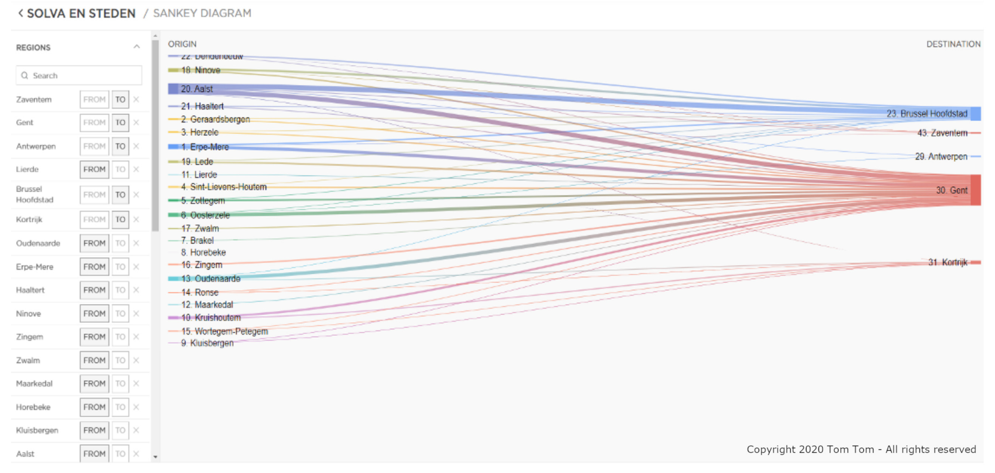
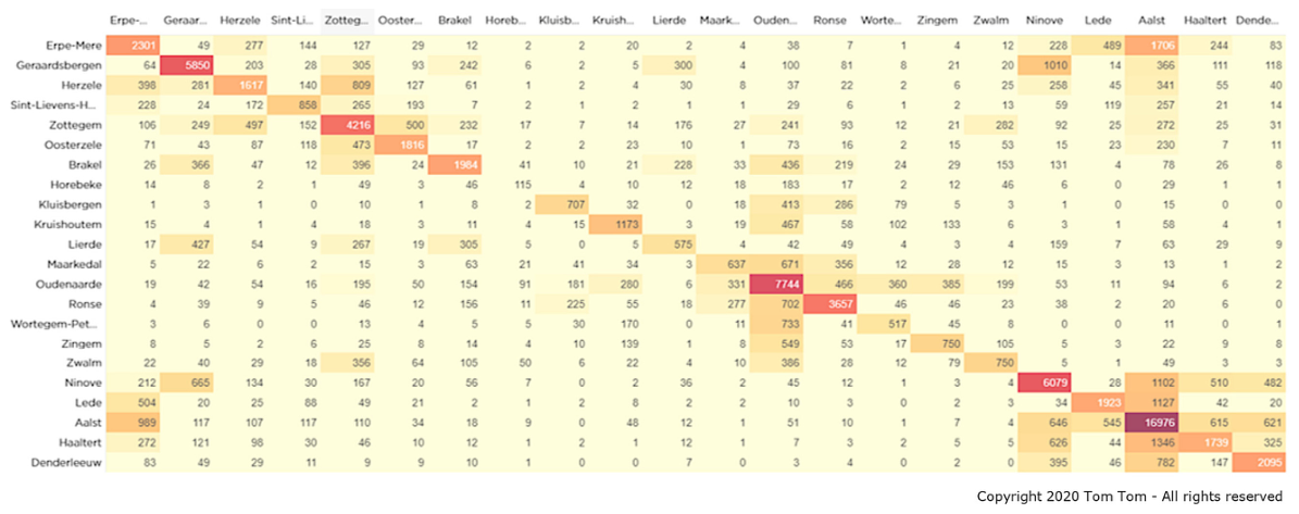
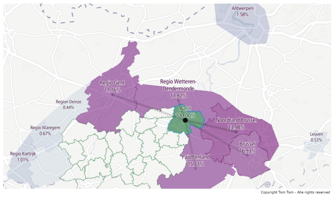
| 4 | Solva region (BE)—Regional traffic behaviour | Dashboard visualisation of origin–destination patterns of floating car data on a regional scale in South-Eastern Flanders and its surroundings |
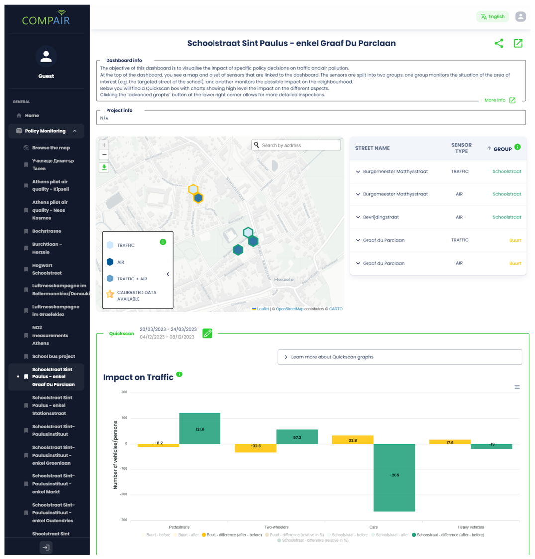
| 5 | Herzele (BE)—Interactive school street dashboard | Dashboard visualising results from multiple sensor types (traffic, air quality PM, NO2, BC) allowing the comparison of two groups of sensors before and after a moment in time (when the measure has been implemented)—applied on a school street implementation case |
| 6 | Mechelen/Flanders (BE)—Interactive school street dashboard | Dashboard visualising traffic count data (cars, big vehicles, cyclists and pedestrians) in and around school streets before and after the implementation of a school street |
| 7 | Sint-Niklaas (BE)—Local mobility scheme/plan dashboard | Dashboard visualising results from multiple sensor types (traffic, air quality PM, NO2, BC) allowing the comparison of two groups of sensors before and after a moment in time (when the measure has been implemented)—applied on a local mobility scheme/plan implementation case |
| 8 | Flanders (BE)—Interactive road safety map | Interactive road safety heatmap for Flanders visualising heatmaps, line and point maps included advanced geo-time and content selection possibilities |
| 9 | Ghent (BE)—Student displacements | Choropleth map visualising dorm higher education student displacements during a reference period in Ghent by using mobile telecommunication data as an alternative way to get relevant policy data about displacement patterns |
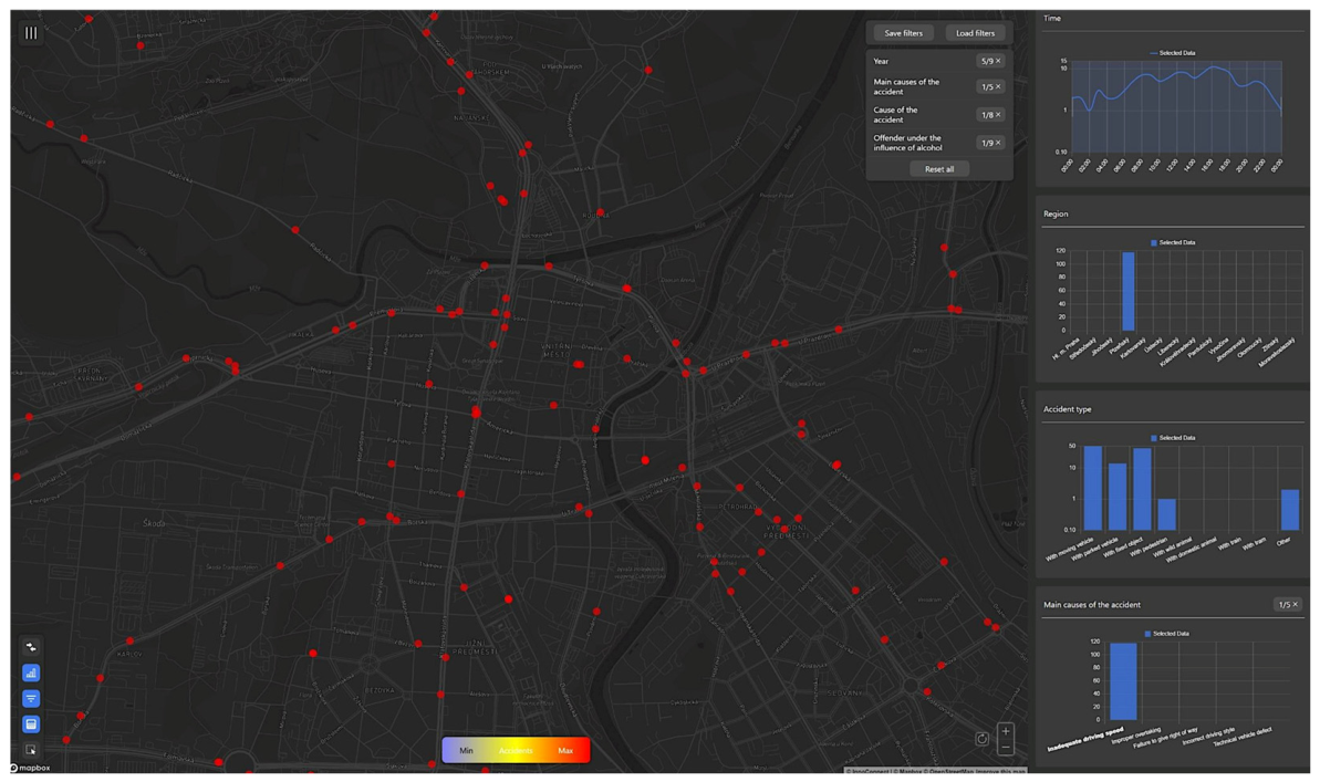
| 10 | Pilsen (CZ)—Interactive road accident map | Interactive road accident heatmap for Pilsen visualising heatmaps and point maps included advanced geo-time and content selection possibilities |
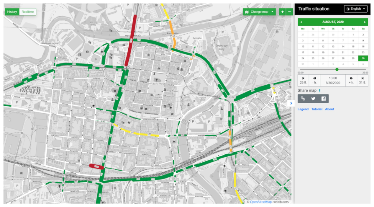
| 11 | Pilsen (CZ)—Interactive sensor based live and historic traffic map | Interactive map visualising live and historic traffic volumes in Pilsen, including advanced data geo-time and content selection possibilities |
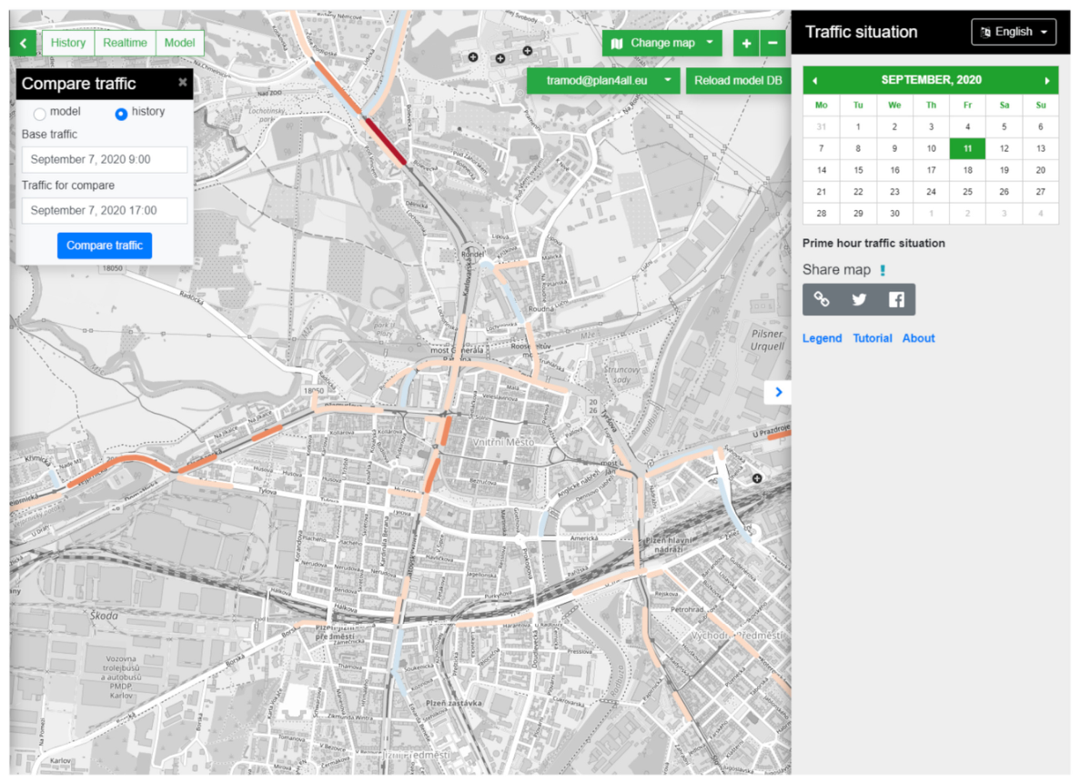
| 12 | Pilsen (CZ)—Traffic measure impact modelling comparison | Traffic volume and intensity line delta map of the results of a traffic calculation using the Pilsen traffic model |
| 13 | Pilsen (CZ)—Traffic volume impact simulation modelling | Traffic volume and intensity line map visualisation of a traffic calculation using the Pilsen traffic model |
| 14 | Issy-les-Moulineaux (FR)—Travel planning app | Optimal multimodal route calculation mobile visualisation app (My Anatol app) offering sustainable route suggestions |
| 15 | Pilsen (CZ)—Impact of roadworks simulation | Traffic volume and intensity line map visualisation of the impact of planned roadworks using the Pilsen traffic model |
| 16 | Athens (GR) Digital Twin—Green squares planning | Visualising the impact of 3D terrain assets (e.g., buildings, constructions, trees, water, street furniture) on the comfort of urban spaces related to liveability, e.g., by avoiding heat stress, using a Digital Twin |
| 17 | Athens (GR) Digital Twin—Traffic load & creation of a pedestrian and cycling route | Visualising traffic volumes, air quality impact, noise pollution impact (absolute volumes and deltas) in a 3D Digital Twin environment-case transforming roads towards low traffic zones to promote walking and cycling |
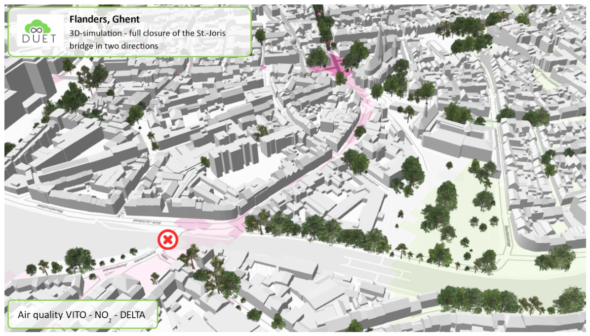
| 18 | Pilsen (CZ), Ghent (BE) Digital Twin—Impact of road closures | Visualising traffic volumes, air quality impact, and noise pollution impact (absolute volumes and deltas) in a 3D Digital Twin environment-case road closures on an existing network |
| 19 | Pilsen (CZ) Digital Twin—Ring road construction impact | Visualising traffic volumes, air quality impact, noise pollution impact (absolute volumes and deltas) in a 3D Digital Twin environment-case new road infrastructure |
| 20 | Pilsen (CZ) Digital Twin—Solar equipment locations in the city park | Visualising the impact of 3D terrain assets (e.g., buildings, other constructions, e.g., bridges, trees) on the potential shadow impact on solar panels in a Digital Twin |
| Case Nr. | Policy Element (Step 1) | Visualisation Goal (Step 2) |
|---|---|---|
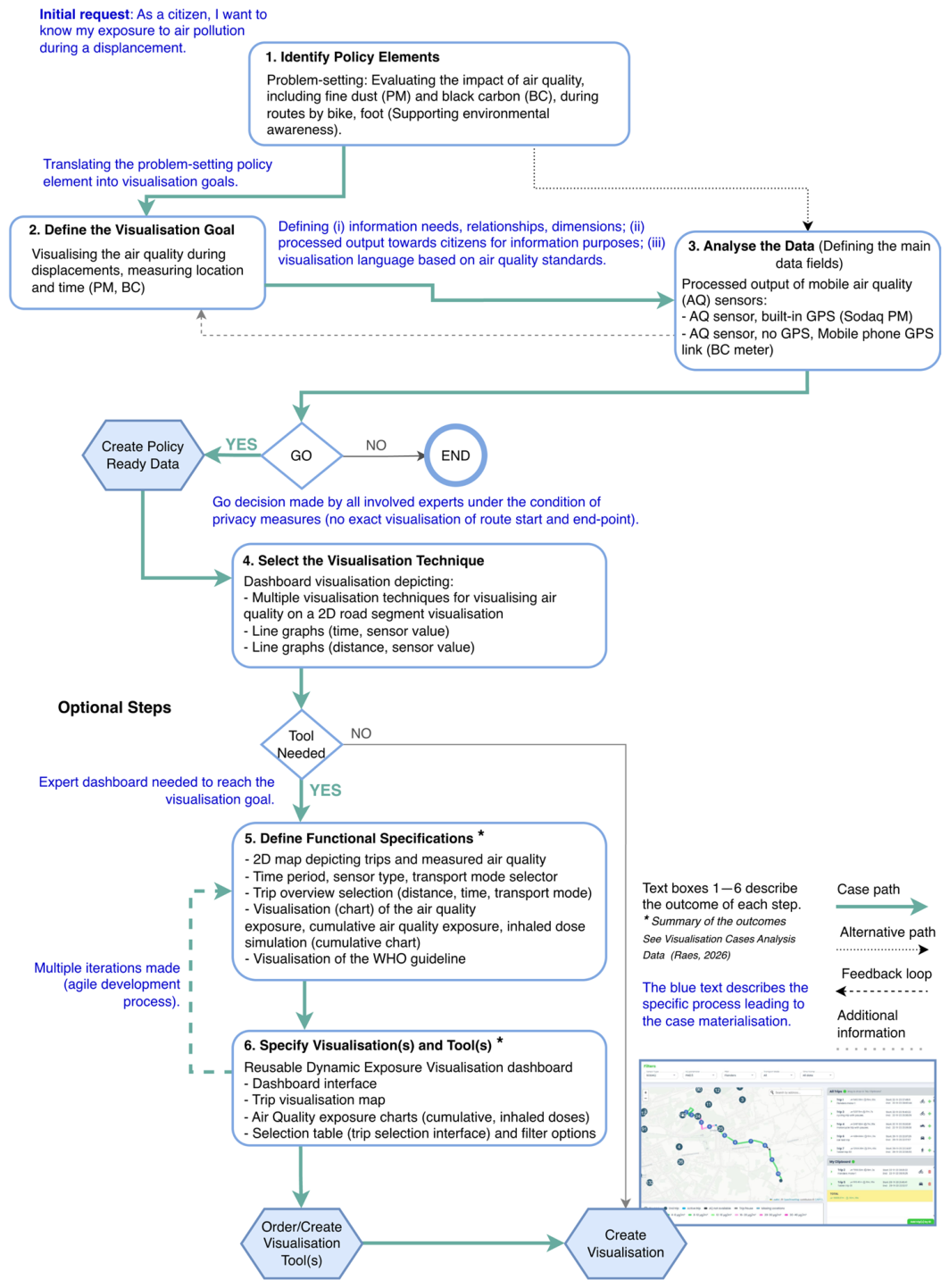
| 1 | Problem-setting: Evaluating the impact of air quality, including fine dust (PM) and black carbon (BC), during routes by bike, foot | Visualising the air quality during displacements, measuring location and time (PM, BC) |
| 2 | Policy goal: Getting better insights and reducing congestion | Visualise how much time a traveller loses on road segments in Issy compared to the ideal situation (no traffic) for specific periods and timings. Show current/actual “Time lost” per road segment. |
| 3 | Problem-setting: Evaluating the impact of average speed control enforcement | Visualising the long-term impact of average speed control zones on speed, fines and even traffic safety (accidents) |
| 4 | Policy goal: Getting insight into the regional mobility streams | Display the displacement patterns (by car) in the South-East Flanders region |
| 5 | Policy goal: Getting insight into the effects of a school street (test) implementation | Visualise the effects of the implementation of a measure on traffic and air quality before and after implementation at multiple geospatial areas |
| 6 | Policy action: Pre- and post-measurement of a school street implementation measure | Visualising the long-term impact of the implementation of a school street by measuring the period before the implementation and after the implementation in the school street itself and the surrounding neighbourhood |
| 7 | Policy goal: Getting insight into the effects of a mobility scheme (test) implementation | Visualise the effects of the implementation of a measure on traffic and air quality before and after implementation at multiple geospatial areas |
| 8 | Problem-setting: Identify the road safety situation | Visualising locations where accidents happened in Flanders in the last 5 years. Regarding the accidents, display information relevant to finding black spots due to the infrastructure |
| 9 | Problem-setting: Getting insights into student displacements | Display on a map the areas with the highest number of students and impact in Ghent |
| 10 | Problem-setting: Identification and agenda-setting via traffic data analysis and evaluation of past policy measures | Visualise traffic volume on road segments in time and space to explore and discover patterns, correlations and extremities using aggregated data |
| 11 | Policy goal: Reduce congestion | Showing actual, historical traffic volume for each road segment |
| 12 | Policy goal: Impact evaluation | Displaying the differences in traffic volumes and intensities for these road segments influenced by the simulated measure |
| 13 | Policy goal: Reduce congestion | Visualising the increase/decrease in traffic volume to compare two moments in time by allowing an expert to select those moments using either measured data from the past or predicted data (model) |
| 14 | Policy goal: Optimal multimodal route planning to enhance the use of sustainable transport modes and to ensure liveability of neighbourhoods | Visualise the optimal travel options, including the time and ecological costs of travel alternatives |
| 15 | Policy goal: Reduce roadworks impact on increase in congestion | Informing the citizens about the impact and time schedules for planned roadworks in the city |
| 16 | Policy action: Simulating the shadow impact of adding greenery and public equipment like benches | Display in 3D the sunshine’s impact on leisure locations (e.g., trees and benches) for every date and time |
| 17 | Policy goal: Evaluating the impact of the close-by traffic load of transforming Stadiou Street in the centre of Athens into a complete pedestrian and cycling route | Display on a 3D map the effect on traffic volume, air quality and noise pollution caused by traffic of changes in existing infrastructure |
| 18 | Problem-setting: Getting insight into the effect of a road closure measure | Display on a 3D map the effect on traffic volume, air quality and noise pollution caused by traffic of changes in existing infrastructure |
| 19 | Problem-setting: Getting insight into the effect of a new ring road | Display on a 3D map the effect on traffic volume, air quality and noise pollution caused by traffic of new road infrastructure impacting the city |
| 20 | Policy action: Simulating the shadow impact on solar equipment efficiency | Display in 3D the sunshine’s impact on locations for every date and time |
| Case | Visualisation | Data and Sensors | Tools and Interactivity | Complexity | |||||||
|---|---|---|---|---|---|---|---|---|---|---|---|
| Nr. | Smart City-Related Visualisation Cases | Visualisation Techniques Used | Visualisation (2D, 3D) | Data Types (YTT) [1] | Data Techniques Aggregation/Anonymisation [2] | Sensors Used | Tools (Digital Twin, Dashboard, Interactive Graphs) | Interactivity (Interactive Selection, Time Selection, Geospatial Navigation, Bi-Directional Dashboard-Map Integration) [5] | Scenario Analysis (Nr of Models/Algorithms | Model Types) | Visualisation (L, M, H) [6] | Policy Application (L, M, H) [7] |
| 1 | Berlin (DE), Flanders (BE)—Dynamic exposure visualisation dashboard |
| 2D | Today, Yesterday | - | Mobile Air Quality | Visualisation Dashboard | IGS, ITS, GN | - | M | M |
| 2 | Issy-les-Moulineaux (FR)—Traffic dashboard |
| 2D | Yesterday | Aggregation | Navigation Device (In Car, Cellphone,...) | Visualisation Dashboard | IGS, ITS, GN | - | M | M |
| 3 | Police zone Voorkempen (BE)—Trajectory speed limit enforcement dashboard |
| 2D | Yesterday | Aggregation, Pseudonimi- sation | ANPR [3] | Visualisation Dashboard | - | - | L | M |
| 4 | Solva region (BE)—Regional traffic behaviour |
| 2D | Today, Yesterday | Aggregation | Navigation Device (In Car, Cellphone,...) | Visualisation Dashboard | IGS | - | L | M |
| 5 | Herzele (BE)—Interactive school street dashboard |
| 2D | Today, Yesterday | Aggregation | Telraam Traffic [4], Static Air Quality | Policy Dashboard | IGS, ITS, GN | - | H | H |
| 6 | Mechelen/Flanders (BE)—Interactive school street dashboard |
| 2D | Today, Yesterday | Aggregation | Telraam Traffic | Policy Dashboard | IGS, ITS, GN | - | M | M |
| 7 | Sint-Niklaas (BE)—Local mobility scheme/plan dashboard |
| 2D | Today, Yesterday | Aggregation | Telraam Traffic | Policy Dashboard | IGS, ITS, GN | 1 | Traffic Model | M | M |
| 8 | Flanders (BE)—Interactive road safety map |
| 2D | Yesterday | - | - | Intensity Map | IGS, ITS, GN, BDMI | - | H | M |
| 9 | Ghent (BE)—Student displacements |
| 2D | Yesterday | Anonymisation, Aggregation | Cellphone | Intensity Map | - | - | L | M |
| 10 | Pilsen (CZ)—Interactive road accident map |
| 2D | Yesterday | - | - | Intensity Map | IGS, ITS, GN, BDMI | - | H | M |
| 11 | Pilsen (CZ)—Interactive sensor based live and historic traffic map |
| 2D | Today, Yesterday | Aggregation | Traffic Sensors (loops, traffic lights) | Intensity Map | IGS, ITS, GN, BDMI | - | H | M |
| 12 | Pilsen (CZ)—Traffic measure impact modelling comparison |
| 2D | Tomorrow, Yesterday | Aggregation | - | Intensity Map, Algorithm Visualisation | ITS, GN | 1 | Traffic Model | M | H |
| 13 | Pilsen (CZ)—Traffic volume impact simulation modelling |
| 2D | Tomorrow, Yesterday | Aggregation | - | Intensity Map, Algorithm Visualisation | ITS, GN | 1 | Traffic Model | M | M |
| 14 | Issy-les-Moulineaux (FR)—Travel planning app |
| 2D | Today, Yesterday | Aggregation | Navigation Device (In Car, Cellphone,...) | Algorithm Visualisation | GN | 1 | Multimodal Optimal Route Planning | M | L [8] |
| 15 | Pilsen (CZ)—Impact of roadworks simulation |
| 2D | Tomorrow, Today, Yesterday | - | - | Algorithm Visualisation | ITS, GN | 1 | Traffic Model | M | H |
| 16 | Athens (GR) Digital Twin—Green squares planning |
| 3D | Yesterday | - | - | Digital Twin | ITS, GN | 1 | Light Impact | M | M |
| 17 | Athens (GR) Digital Twin—Traffic load & creation of a pedestrian and cycling route |
| 2D/3D | Tomorrow, Yesterday | - | - | Digital Twin | ITS, GN | 2 | Traffic Model + Air Quality Model | H | H |
| 18 | Pilsen (CZ), Ghent (BE) Digital Twin—Impact of road closures |
| 2D/3D | Tomorrow, Yesterday | - | - | Digital Twin | ITS, GN | 3 | Traffic Model + Air Quality and Noise Model | H | H |
| 19 | Pilsen (CZ) Digital Twin—Ring road construction impact |
| 2D | Tomorrow | - | - | Digital Twin | ITS, GN | 1 | Traffic Model | M | M |
| 20 | Pilsen (CZ) Digital Twin—Solar equipment locations in the city park |
| 3D | Tomorrow | - | - | Digital Twin | ITS, GN | 1 | Light Impact | M | L |
| Policy Design | Policy Implementation | Policy Evaluation | |||||||||
|---|---|---|---|---|---|---|---|---|---|---|---|
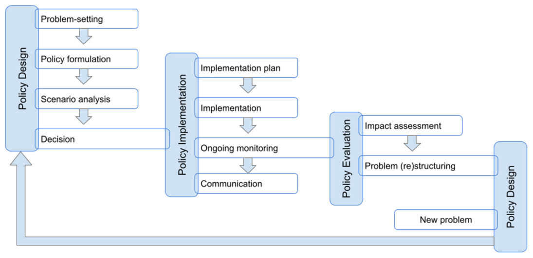
| Problem- Setting | Policy Formulation | Scenario Analysis | Decision | Implementation Plan | Implementation | Ongoing Monitoring | Communication | Impact Asessment | Problem (Re)structuring | ||
| Case Nr. | Dashboard Visualisation | ||||||||||
| Visualisation DB | |||||||||||
| 1 | Berlin (DE), Flanders (BE)—Dynamic exposure visualisation dashboard | V | - | - | - | - | - | V | V | - | - |
| 2 | Issy-les-Moulineaux (FR)—Traffic dashboard | V | - | - | - | - | - | - | V | V | - |
| 3 | Police zone Voorkempen (BE)—Trajectory speed limit enforcement dashboard | - | V | - | - | - | - | V | - | V | V |
| 4 | Solva region (BE)—Regional traffic behaviour | V | V | - | - | - | - | - | - | - | - |
| PolicyDB | |||||||||||
| 5 | Herzele (BE)—Interactive school street dashboard | V | - | - | V | - | - | V | V | V | - |
| 6 | Mechelen/Flanders (BE)—School street dashboard | V | V | - | - | V | V | V | V | V | V |
| 7 | Sint-Niklaas (BE)—Local mobility scheme/plan dashboard | V | - | V | V | V | - | V | V | V | V |
| Intensity map visualisation | |||||||||||
| 8 | Flanders (BE)—Interactive road safety map | V | V | - | - | V | - | - | V | V | - |
| 9 | Ghent (BE)—Student displacements | V | V | - | - | - | - | - | - | - | - |
| 10 | Pilsen (CZ)—Interactive road accident map | V | V | - | - | - | - | - | V | V | - |
| 11 | Pilsen (CZ)—Interactive sensor based live and historic traffic map | V | - | - | - | - | - | - | V | V | - |
| 12 | Pilsen (CZ)—Traffic measure impact modelling comparison | V | V | V | V | V | V | V | - | V | V |
| 13 | Pilsen (CZ)—Traffic volume impact simulation modelling | V | - | - | - | - | - | - | V | - | - |
| Algorithm visualisation | |||||||||||
| 14 | Issy-les-Moulineaux (FR)—Travel planning app | - | - | - | - | - | - | - | V | - | - |
| 15 | Pilsen (CZ)—Impact of roadworks simulation | V | V | V | V | V | V | V | V | V | V |
| Digital Twin visualisation | |||||||||||
| 16 | Athens (GR)—Digital Twin, Green squares planning | V | - | V | V | V | - | - | V | - | - |
| 17 | Athens (GR)—Digital Twin, Traffic load & creation of a pedestrian and cycling route | V | - | - | V | V | - | - | V | V | - |
| 18 | Pilsen (CZ), Ghent (BE)—Digital Twin, Impact of road closures | V | V | V | V | V | - | - | V | V | V |
| 19 | Pilsen (CZ)—Digital Twin, Ring road construction impact | V | V | V | V | V | - | - | V | V | V |
| 20 | Pilsen (CZ)—Digital Twin, Solar equipment locations in the city park | V | - | V | V | V | V | - | - | V | - |
| Phase | Policy Design | Policy Implementation | Policy Evaluation | |||||||
|---|---|---|---|---|---|---|---|---|---|---|
| Subphase | Problem- Setting | Policy formulation | Scenario Analysis | Decision | Implementation Plan | Implementation | Ongoing Monitoring | Communication | Impact Assessment | Problem (Re)structuring |
| Dashboard visualisation | 6/7 | 3/7 | 1/7 | 2/7 | 2/7 | 1/7 | 5/7 | 5/7 | 5/7 | 3/7 |
| -Visualisation DB | 3/4 | 2/4 | 0/4 | 0/4 | 0/4 | 0/4 | 2/4 | 2/4 | 2/4 | 1/4 |
| -PolicyDB | 3/3 | 1/3 | 1/3 | 2/3 | 2/3 | 1/3 | 3/3 | 3/3 | 3/3 | 2/3 |
| Intensity map visualisation | 6/6 | 4/6 | 1/6 | 1/6 | 2/6 | 1/6 | 1/6 | 4/6 | 4/6 | 1/6 |
| Algorithm visualisation | 1/2 | 1/2 | 1/2 | 1/2 | 1/2 | 1/2 | 1/2 | 2/2 | 1/2 | 1/2 |
| Digital Twin visualisation | 5/5 | 2/5 | 4/5 | 5/5 | 5/5 | 1/5 | 0/5 | 4/5 | 4/5 | 2/5 |
| Percentage/subphase | 90% | 50% | 35% | 45% | 50% | 20% | 35% | 75% | 70% | 35% |
| Percentage/phase | 55% | 45% | 53% | |||||||
Disclaimer/Publisher’s Note: The statements, opinions and data contained in all publications are solely those of the individual author(s) and contributor(s) and not of MDPI and/or the editor(s). MDPI and/or the editor(s) disclaim responsibility for any injury to people or property resulting from any ideas, methods, instructions or products referred to in the content. |
© 2026 by the authors. Published by MDPI on behalf of the International Society for Photogrammetry and Remote Sensing. Licensee MDPI, Basel, Switzerland. This article is an open access article distributed under the terms and conditions of the Creative Commons Attribution (CC BY) license.
Share and Cite
Raes, L.; Crompvoets, J. Visualisation Methodology for Informed Decision-Making Applied to Smart City and Digital Twin Contexts. ISPRS Int. J. Geo-Inf. 2026, 15, 231. https://doi.org/10.3390/ijgi15060231
Raes L, Crompvoets J. Visualisation Methodology for Informed Decision-Making Applied to Smart City and Digital Twin Contexts. ISPRS International Journal of Geo-Information. 2026; 15(6):231. https://doi.org/10.3390/ijgi15060231
Chicago/Turabian StyleRaes, Lieven, and Joep Crompvoets. 2026. "Visualisation Methodology for Informed Decision-Making Applied to Smart City and Digital Twin Contexts" ISPRS International Journal of Geo-Information 15, no. 6: 231. https://doi.org/10.3390/ijgi15060231
APA StyleRaes, L., & Crompvoets, J. (2026). Visualisation Methodology for Informed Decision-Making Applied to Smart City and Digital Twin Contexts. ISPRS International Journal of Geo-Information, 15(6), 231. https://doi.org/10.3390/ijgi15060231

