Abstract
Urban and territorial development increasingly threatens the preservation of architectural heritage, often leading to degradation or loss. Many historic architectural works, once integral to community identity, now face the impacts of time and neglect. Addressing these challenges requires innovative solutions, and digital technologies offer significant potential for the conservation and enhancement of cultural heritage. This study employs reality-based 3D modeling techniques to generate accurate digital reconstructions of the Church of Santa Croce in Ravenna (Italy), used here as a case study to demonstrate a workflow for phasing analysis and interactive visualization of architectural transformations. The objective is not to produce a philological reconstruction, but to propose a methodological approach for digitally documenting and visualizing, with geometric rigor, the different constructive phases of historical buildings that have undergone structural changes. Using a spatial–temporal navigation approach, the research explores the various historical phases of the site within an interactive 3D virtual environment. The resulting platform facilitates both scholarly investigation and public engagement by providing immersive visualization and enhanced understanding of the monument’s transformation over time. Through this case study, the project underscores the critical role of contemporary digital tools in cultural heritage conservation and explores novel methods for communicating and disseminating historical knowledge.
1. Introduction
The preservation of historic buildings represents a key practice in the cultural heritage field, serving not only to protect physical structures but also to conserve the collective memory and identity of societies. These buildings often reflect the social, religious, and architectural values of their time, offering a tangible connection to past eras. As such, they provide valuable insights into the everyday lives, customs, and systems of previous generations, helping researchers and the public to better understand the historical evolution of human societies. However, with the acceleration of urbanization and modernization in many regions, historic architecture is increasingly at risk [1,2]. Many of these structures suffer from neglect, abandonment, or even demolition due to several factors, including environmental issues, changing land use, and economic or tourist pressures [3,4].
In response to these challenges, the academic and professional communities have shown a growing interest in developing and applying innovative strategies for documenting and protecting architectural heritage. Conventional on-site data collection techniques—such as manual surveying, photogrammetry, and archival research—remain essential and continue to play a fundamental role in heritage studies [5]. Nevertheless, the integration of digital technologies for surveying and data management has significantly expanded the possibilities for documenting and visualizing heritage. Today, it is feasible to implement end-to-end digital workflows that span from the initial data acquisition phase through to the final stages of visualization, dissemination, and education [6,7].
In particular, the use of digital technologies to visualize and reconstruct lost or damaged heritage sites has emerged as a promising and increasingly critical area of study. Digital reconstruction, as a concept, refers to the use of digital tools and techniques to recreate cultural heritage assets, including those that have been partially or wholly lost [8]. This process can involve a range of methodologies, including 3D modeling, laser scanning, photogrammetry, and Geographic Information Systems (GIS), supplemented by historical documentation and expert interpretation [9]. Over the past decade, the convergence of digital technologies and heritage preservation has given rise to a new interdisciplinary field that combines aspects of architecture, archeology, computer science, and geo-information science. One of the most transformative tools in this context is Virtual Reality (VR), which has been recognized for its potential to offer immersive and interactive experiences of historical environments [10]. By bridging the gap between the physical and digital worlds, VR allows users to explore reconstructed heritage spaces in ways that were previously impossible, for instance enabling the exploration of underwater cultural properties [11].
The benefits of VR for heritage conservation are multiple. First, it supports the creation of accurate and detailed digital archives, which can serve as valuable references in case of future restoration or reconstruction needs. Second, it allows users to interact with sensitive or fragile artifacts in a non-invasive manner, thereby reducing the risk of physical damage. Third, and most relevant to this study, VR enables the digital reconstruction of monuments and buildings that no longer exist or are only partially preserved [12,13]. These reconstructions can provide a more comprehensive understanding of the original structure, its spatial arrangement, and its historical significance. Moreover, in virtual environments, it is possible to showcase the different constructive phases of ancient buildings that have undergone changes in their structure and/or esthetic, which may be due to natural or environmental factors or human intervention.
Recent contributions from the related scientific literature exemplify this type of application. In [14] the authors present a sophisticated VR reconstruction of the Cathedral of Palermo, focusing on its pre-18th-century layout. Their work combines laser scanning, historical documentation, and real-time rendering to offer an immersive exploration of the monument’s evolution. Interactive features, such as inspectable artifacts, morphing between historical configurations, and multimedia integration, enhance user engagement. Similarly, in [15], the researchers describe the VR reconstruction of Villa Michaelsen in Hamburg, which encompasses the three phases of the building’s construction. Using a combination of geomatic-based digitization and archival research, their project delivers a historically accurate VR environment, including audio-visual content, to deepen the user’s understanding of architectural transformation.
Other scholars have developed end-to-end workflows that leverage photogrammetry, archival research, and analog architectural comparisons to reconstruct buildings from similar historical periods. For example, in [16], the authors used UAV-based photogrammetry and historical documentation to create detailed 3D reconstructions of the early Christian temples of the Roman fortress of Pitiunt; their methodology clarifies the ground plan, studies excavated materials and architectural analogs, constructs and verifies the 3D models, and produces final visualizations for public dissemination.
The reconstruction workflows discussed so far share a common reliance on 3D geometries as the primary means of conveying historical information. These approaches demonstrate the value of digital modeling and visualization for communicating changes in architectural form, yet they generally treat the model as a static output rather than as a dynamic repository of data. As the complexity of heritage narratives increases and the need for rigorous documentation grows, scholars have begun to explore methodologies that couple three-dimensional representation with explicit information management. In this context, Historic Building Information Modeling (HBIM) emerges as a next step in heritage digitization, providing a framework that integrates metric accuracy with semantic richness and allowing geometric entities to be linked directly to archival records, material characteristics and conservation histories.
In this sense, examples can be found in [17], where the authors documented and virtually restored the Santo Stefano church in Volterra, Italy, using low-altitude UAV photogrammetry, control-point measurement, heritage-building information modeling and VR; their workflow integrates detailed point-cloud acquisition, and immersive visualization to reconstruct the church’s original appearance. A further contribution that broadens this landscape is provided by the work of Klapa et al. [18], who apply a HBIM framework to the wooden Church of the Dormition of the Mother of God in Żmijowiska, Poland. In their study, the authors integrate high-resolution geometric data from terrestrial laser scanning and photogrammetry with plans, archival photography, and stylistic analysis; through this multisource data fusion, they reconstruct the building at four key moments (1881, 1930, 1990, and the present day) and organize the resulting models along a chronological timeline. All geometric and non-geometric evidence is thus incorporated into a unified HBIM environment where each element is semantically annotated with material, structural function and phase of construction. Unlike the static 3D models and VR experiences discussed earlier, this approach delivers a multitemporal, information-rich representation that not only visualizes the monument’s physical evolution but also supports detailed analysis and preservation planning.
As seen, scholars over time have implemented different strategies to document, analyze and visualize heritage building changes over time, ranging from static 3D reconstructions to parametric modeling with HBIM and VR-based experiences. The project described in this paper is situated in this research context, presenting a methodological proposal for reconstructing and visualizing heritage sites that have undergone significant transformations over time.
However, compared to similar works in this field as those mentioned previously, our workflow presents aspects of novelty and peculiarity. In particular, our approach differs in terms of temporal segmentation, interaction design, and survey–archive integration—while deliberately trading HBIM semantics for a lightweight, highly communicative VR pipeline. Prior VR exemplars typically privilege a single historical state or present multi-phase content as largely static models for immersive exploration: the Palermo Cathedral tour [14], though meticulously grounded in laser scanning and real-time rendering, focuses on a pre-eighteenth-century configuration as an edutainment experience rather than a multi-state, data-driven apparatus; the Villa Michaelsen application [15] offers an accurate, game-engine experience across three building stages, but treats the 3D model chiefly as an output for navigation rather than a dynamic information substrate. Reconstruction-centric work at Pitiunt [16] emphasizes archeological reasoning and engineering verification (UAV photogrammetry, structural checks, mosaic restitution) to deliver detailed exterior/interior models, yet its primary contribution remains the authoritative visualization of hypothesized states. In contrast, HBIM-forward approaches [17,18] embed point-cloud–derived geometry within semantically enriched, multi-source models to support documentation, change analysis, and asset management; in [18] a four-epoch timeline is organized natively inside an HBIM environment with explicit linkage to archival and stylistic evidence.
Our contribution positions itself between these strands: we couple centimeter-accurate, integrated geomatics with systematic digitization and vectorization of historical drawings to build phase-specific models that are validated metrically against the present survey, and then bind those phases through an interactive, VR-based timeline that animates additive/subtractive transformations and surfaces contextual evidence in situ. This design—implemented via SketchUp→Twinmotion to prioritize rapid geometric reconstruction and robust HMD delivery—produces a spatiotemporal narrative that is simultaneously rigorous (survey-constrained) and legible to non-specialists, complementing HBIM pipelines by excelling in communication and public engagement. Methodologically, the novelty lies in (i) explicit, survey-anchored temporal segmentation; (ii) a timeline-triggered animation grammar for phase transitions; and (iii) an end-to-end pipeline that reconciles heterogeneous sources without imposing HBIM overhead, while remaining compatible with future HBIM integration for semantic enrichment and lifecycle management.
It is essential to note that the objective is not to provide a philological analysis of the subject—the Church of Santa Croce—but rather to propose a methodological approach that can be applied to similar cases involving the visualization of architectural change in historical buildings. Specifically, this project aims to demonstrate how VR facilitates spatially coherent interaction with ancient structures, thereby supporting educational and scholarly endeavors while contributing to the preservation and transmission of cultural knowledge for future generations, in line with recent research in the field [19,20].
2. Research Context and Case Study
2.1. The SHELTER Research Project
To mitigate the vulnerability of cultural and archeological heritage, enhance its preservation, and promote its conservation, it is essential to identify and develop disaster risk management plans, along with protocols and methodologies, designed to enhance the resilience of areas of interest. To these aims, several projects at national and international levels have been developed, including the Horizon 2020 project SHELTER (Sustainable Historic Environments holistic reconstruction through Technological Enhancement and community-based Resilience), founded by the European Union. Among its case studies is the Santa Croce complex in Ravenna, selected because the site is threatened by subsidence, flooding and seismic activity [21,22].
The University of Bologna, a partner in the project through the Interdepartmental Centre for Industrial Research in Building and Construction, has assembled a team of researchers from diverse fields of expertise to conduct activities in the area using a multidisciplinary approach. In particular, the surveying activities of the Church of Santa Croce and its surrounding archeological area were conducted in 2021 by the Geomatics group of the Department of Civil, Chemical, Environmental, and Materials Engineering (DICAM) at the University of Bologna. This comprehensive campaign employed a consolidated geomatic-based methodology combining terrestrial laser scanning, UAV-based photogrammetry, GNSS positioning, and topographical measurements. The integrated approach adopted enabled a robust acquisition of spatial data, capturing the geometry of the site and its surroundings, as well as its preservation conditions at millimeter-level accuracy. This rigorous documentation facilitated the construction of a H-BIM (Historic-Building Information Modeling) as-built model, at a centimeter-level of detail, enabling a thorough understanding of the monument’s structure and geometry, while providing the foundational 3D model essential for subsequent digital conservation efforts [23]. These activities were undertaken in close cooperation with local and regional heritage and risk-management bodies, including the Superintendence, the Diocese and Municipality of Ravenna, and the regional agency ARPAE, situating the case study within a broader European framework for cultural heritage preservation and adaptive management [24,25].
2.2. The Church of San Croce in Ravenna (Italy)
The Church of Santa Croce in Ravenna, Italy, (Figure 1a) is considered a prominent example of Byzantine architecture, built at the order of the Empress Galla Placidia in the first half of the 5th century. This architectural marvel is historical evidence of Ravenna’s place as one of Italy’s principal centers of Byzantine art and culture [26]. Initially, the church structure used to be a single nave Latin cross completed by a narthex (ruins of the original structure are visible in Figure 1b). Shortly afterward, among other changes, a chapel at the South end of the complex was added, which today is known as Galla Placidia Mausoleum [27].
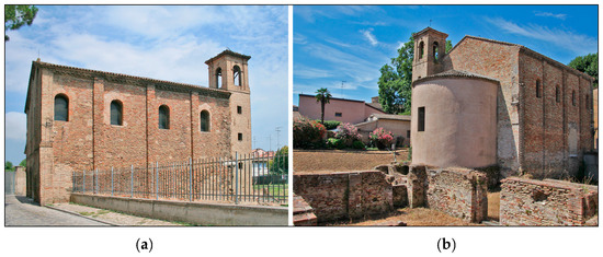
Figure 1.
(a) Side view of the Santa Croce church exterior (b) View of the church apse exterior, also showing the archeological ruins of its primitive structure [26].
Numerous hazards threatened the Church of Santa Croce. Seismic actions with various epicenters and magnitudes have damaged the building on multiple occasions throughout history. For instance, the 467 AD earthquake of Ravenna, with an intensity of 4.3, and the 725 AD earthquake of Classe, with an intensity of 5.6, brought considerable damage and demolition to the complex. Several renovations and modifications have been made to the church over the centuries. The church’s present layout goes back to the 17th century when significant alterations were made to the remnants of the original structures. Today, it is only possible to see the 15th-century apse, the 17th-century austere facade, and its most striking exterior feature, a prominent bell tower added in the 18th century [28].
Among all the modifications to the Santa Croce complex, a notable change was the separation of the Mausoleum of Galla Placidia, which was brutally detached from the complex at the beginning of the 17th century, as evident from current Ravenna cartography (Figure 2). This detachment significantly altered the layout and historical integrity of the site.
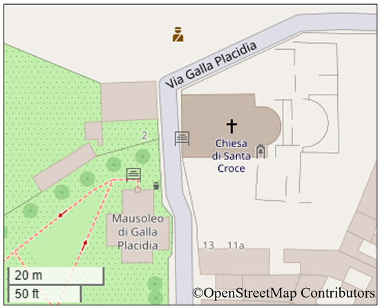
Figure 2.
OpenStreetMap view of Santa Croce complex and Galla Placidia Mausoleum area in Ravenna, showing that the two structures are now independent.
3. Methodology
3.1. Introduction to the Adopted Workflow and Preliminary Steps
This section outlines the workflow adopted for the digital reconstruction of the heritage site described above, with a focus on integrating digital technologies into the preservation process. The methodology employs a multidisciplinary and systematic approach to produce accurate and meaningful representations of the architectural features of the Santa Croce church. The overall process is illustrated in the workflow diagram (Figure 3). The process begins with the digitization of historical documentation, including architectural drawings, photographs, and textual records. These sources are analyzed and cross-referenced with contemporary geomatic surveying data—obtained during the 2021 surveying campaign which established a consistent and comprehensive basis for reconstruction of HBIM model of the current state, as described in [23]. Based on the geometric component of this initial data, detailed 3D CAD models are then developed to reflect the geometric and architectural characteristics of the building in the past In line with the purpose of this work, the methodological decision prioritized rapid geometric reconstruction over the semantic enrichment capabilities of BIM-oriented Platforms. Focusing on modeling the geometric component for VR implementation, it should be noted that a non-BIM-oriented modeling environment was chosen for the models of the Santa Croce complex.
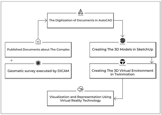
Figure 3.
Schematic workflow of the implemented methodology.
To ensure clarity in the reconstruction process, the historical development of the church was divided into distinct construction phases, based on the chronology and significance of structural modifications and related events. The steps undertaken in this study are detailed in the subsequent chapter.
The modeling stage incorporates advanced 3D modeling and texturing techniques, addressing challenges such as data inconsistency, incomplete documentation, and geometric complexity. In the final stage, the 3D content is imported into rendering software to enable its use in virtual reality environments. This step allows interactive visualization of the architectural phases of the Santa Croce church, supporting user engagement and expert analysis. The digital strategies employed are grounded in metric information derived from historical sources and current geomatic data.
Following the comprehensive survey campaign of the church of Santa Croce conducted by DICAM in April 2021, a comprehensive 3D model was generated by combining 3D laser scanning and digital photogrammetry (Figure 4).
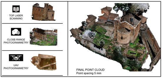
Figure 4.
Realization of the final point cloud model of Santa Croce Complex [22] by integrating different geomatic techniques.
All the data are georeferenced thanks to GNSS in NRTK and classical topographical surveys [23]. The resulting 3D model (Figure 5) served as the primary material for the study of Santa Croce Complex in its current state, and as a robust metrical reference (at centimeter-level accuracy) for all subsequent 3D geometric reconstruction operations.
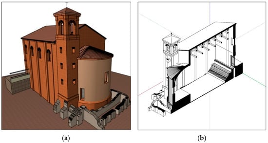
Figure 5.
(a) The final 3D model of Santa Croce Complex [23]; (b) Longitudinal section derived from the church 3D model.
However, the Church of Santa Croce has undergone considerable changes throughout its history, and the survey outcome may only represent the current state of the building configuration. Hence, the research scope had to be expanded to incorporate ancient documents and archival records associated with the building, in order to gather comprehensive data for the study’s purposes.
This involved investigating historical records, architectural plans, and other relevant documents of the church that have survived through the ages. In the case of the church of Santa Croce, the related materials were mainly extracted from an extensive record of published articles and books. Figure 6 is an example of a document found in published books in which reconstructive hypotheses are made by scholars who have analyzed the archeological remains of the complex and archival resources [29]. This exertion led to a primitive challenge of the work at its early stage, which was managing, analyzing, and filtering several data sources for a case study erected centuries ago with a significant history of transformations.

Figure 6.
Santa Croce church’s general plan indicates the preserved, non-preserved, and hypothetical structures [29].
By cross-referencing the survey campaign results with historical documents, a more comprehensive and geometrically reliable dataset was established to support the reconstruction process. To ensure clarity and manageability, the building’s development was segmented into distinct construction phases, identified based on the sequence and significance of architectural modifications and the historical events that prompted them (Figure 7). The methodological steps taken in this study are organized into the following phases and are detailed in the subsequent subsection.

Figure 7.
Timeline diagram.
3.2. Documents and Drawings Digitization
The path followed for this case study involved creating digital-format architectural plans and sections that represented various construction phases. To do so, we collected historical plans and sections (analogical sources) drawn from published monographs and survey reports. Specifically, we vectorized drawings from Cassanelli et al.’s volume on the Basilica di Santa Croce [27], from Ricceri’s study of the Santa Vitale–Galla Placidia–Santa Croce area [28], and the general plans and reconstructive hypotheses compiled by David [29]. The documents were scanned at high resolution, then imported into Autodesk AutoCAD (v. 24.3) where they were converted into editable vector drawings using built-in raster-to-vector tools to trace walls, openings, and other features, using scale bars and self-defined reference points to ensure accurate scaling. The resulting vector drawings provided a consistent set of 2D documents for each phase and a reliable foundation for subsequent 3D modeling (Figure 8).

Figure 8.
Creating digital architectural drawings of Santa Croce church in CAD software.
The primary goal of this case study was to demonstrate the transformation of construction phases over time, allowing us to navigate virtually and observe the church’s evolution on a VR platform. A key step in achieving this goal was comparing the changes in the plan and shape of the building from its initial state to its current format. With this approach in mind, subsequent phases were consistently drawn with respect to the boundaries and foundations of previous ones. Figure 9 illustrates two sequential construction phases between the 7th and 17th centuries. It is visible that the second phase (orange-colored) is drawn in relation to the previous phase (black-colored). As the phases progress, the boundaries and structures of the buildings often undergo demolition and reduction in volume. In this way, the changes over time become more perceptible.

Figure 9.
Comparison of two different construction phases in CAD software. The newly added architectural components—present in a subsequent construction phase—are highlighted in red.
However, this stage of the process was not without limitations. The potential loss of detail during the scanning process, the necessity for manual corrections, and the time-consuming nature of digitization posed significant challenges. Despite these hurdles, the digitization phase provided a solid foundation for the subsequent stages of the digital reconstruction process. Two-dimensional digital documents provided the path for generating accurate 3D models, enabling a seamless transition from flat representations to spatial reconstructions. These documents, resulting from the digitization process, present detailed information on each of the four construction phases of the church (Figure 10 and Figure 11).

Figure 10.
Diagram of the phasing of the church visualized as 2D Sections.
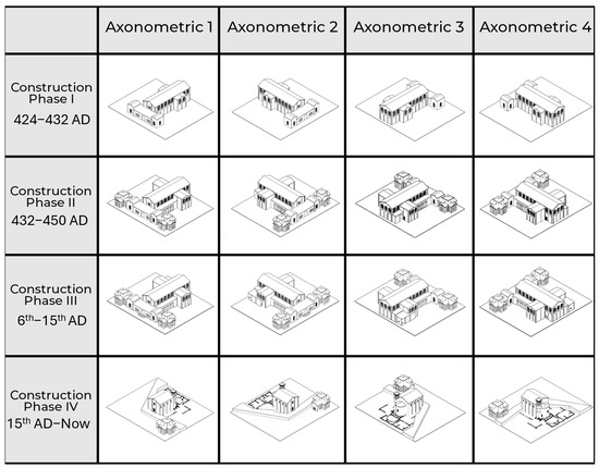
Figure 11.
Axonometric views of the different construction phases.
3.3. Constructing the 3D Models
In the following stage, the generation of 3D models based on digital documents commences. Considering the final purpose of the study and the availability of resources, the modeling software selected for this step was SketchUp by Trimble. First, basic geometric shapes of the first construction phase of the church were extruded to visualize the primary architectural elements of the scanned blueprints. Layers and components were assigned to different model parts to maintain organizational clarity and facilitate future modifications. The 3D model gradually took shape, adhering to the proportions and design intent captured in the scanned documents. After creating the basic geometry, detailing and refining the 3D model were applied, adding additional layers of complexity and realism to the model. After completing the model of the first construction phase, creating subsequent phases involved a systematic approach to modifying the existing 3D model based on comparisons with plans generated in AutoCAD (Figure 12).

Figure 12.
Diagram of the phasing of the church visualized as 3D models. The newly added architectural components—present in a subsequent construction phase—are highlighted in red.
Although SketchUp provides basic capabilities for creating 3D models of architectural sites and facilitates the visualization of different construction phases, it lacks advanced presentation features. This limitation reduces its effectiveness for producing dynamic and interactive visualizations within the software environment. Consequently, the workflow proceeded with the transition to a more suitable platform for developing a detailed 3D environment. As in the previous stage, the models were generated based on the 2D drawings produced for each identified construction phase.
This process presented several challenges, primarily due to gaps in the available information regarding the building’s original form and architectural typology. Addressing these challenges required an extended review of historical documentation, including early sketches and three-dimensional representations from earlier periods of the site’s history. To ensure geometric fidelity despite these uncertainties, the reconstructed models were subjected to iterative alignment and consistency checks. After each modeling iteration, the geometry was compared with the survey-derived point clouds and digitized drawings, and adjustments were made to minimize as much as possible the dimensional deviations within the tolerances of the measured data. Although we did not conduct a formal quantitative uncertainty analysis, this verification process helped ensure that the resulting models accurately reflected both the metric survey information and the historical evidence. In addition to archival sources, the presence of surviving architectural elements of the church contributed significantly to the data acquisition process. These remnants provided measurable references and supported a more accurate interpretation of the building’s design evolution, complementing the information obtained from historical documents.
3.4. Creating the Virtual Environment
After the construction of the 3D models, the selected rendering software for the subsequent rendering and visualization steps was Twinmotion by Epic Games. The primary reason for choosing this software among others was its ability to support HMD (Head-Mounted Displays) VR headsets and the integrated animation functions, which proved highly suitable for the purposes of this study. With translation animation, it was possible to move the architectural elements belonging to different construction phases of the building forward and up, and to trigger the animation to hide or show them interactively. An example of this “phase transition” strategy with animation functions applied to the modeled blocks is shown in Figure 13.

Figure 13.
Construction phase transition implementation in Twinmotion. The blue arrows indicate the translation applied to the building elements of phase 2, allowing to show or hide them with animation triggers positioned in the virtual scene.
Twinmotion was also used to enhance the visual quality of the imported models by applying high-resolution materials and textures. In this environment, original texture images captured from the building were applied to replace generic materials, contributing to a more realistic representation. This step facilitates the more effective communication of the building’s design characteristics and historical context to both expert and non-specialist audiences. By utilizing these material mapping capabilities, the visual fidelity of the reconstruction was improved, resulting in a more immersive digital representation.
Moreover, certain surfaces within the complex, such as specific areas of mosaic flooring and tile patterns, featured distinctive textures and were also documented with high-resolution images during the 2021 survey campaign. An example is shown in Figure 14, illustrating a surviving section of the mosaic flooring located on the south porch. In the next step, the images were added to Twinmotion’s materials library to be applied as textures to the 3D model.

Figure 14.
Material creation of mosaic flooring of the southern porch and texture addition. “A” and “B” represent two individual textures files.
The primary outcome of this phase was the development of a visually detailed and immersive virtual environment that could represent the architectural and historical significance of Santa Croce church. This environment enables users to explore the church across its various historical construction phases, highlighting the architectural details and craftsmanship that characterize its development. However, this phase encountered limitations in accurately reproducing textures and materials. Significant portions of the building, including flooring in several areas, had been demolished, and the available historical documentation was insufficient or incomplete, making it challenging to support precise modeling of these elements.
As a result, some parts of the reconstruction relied on informed assumptions or were omitted, which may affect the completeness of the virtual representation. Despite these challenges, the final 3D models implemented in Twinmotion (Figure 15) presented a chronological sequence corresponding to four construction phases of the Santa Croce Church. The application of textures and realistic lighting within Twinmotion improves both the visual quality of the models, facilitating a more immersive interpretation of the church’s architectural evolution.

Figure 15.
Rendered 3D models representing the chronological sequence of construction evolution.
After completing the model in Twinmotion, the final phase involved selecting an approach that would enable the most interactive and informative visualization. To represent the evolution of the church over time, a timeline-based navigation system was implemented. This system guides the user along a predefined path that corresponds to different historical construction phases, allowing the building’s modifications—such as additions, removals, and structural changes—to be visualized dynamically. As users walk along this virtual path within the VR environment, they encounter a series of trigger points embedded in the ground (Figure 16). When a user reaches one of these points, a set of translation animations is activated. These animations modify the 3D model in real-time, simulating the structural transformation of the building at that particular stage in its history. Architectural elements are added or removed, reconfiguring the model to reflect the corresponding phase of construction.
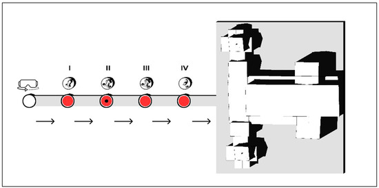
Figure 16.
Timeline approach diagram of the VR experience. The numbers I, II, III and IV represent the different construction phases; the red circles represent the trigger points where the user (black dot) is positioned to activate the animations of the phase transition.
This approach enables users to experience both spatial and temporal navigation. Physically, they move through the virtual environment, while simultaneously progressing along a chronological timeline of the building’s development. The path begins at an initial point and leads to the present-day digital reconstruction of the Church of Santa Croce. Along the way, users virtually “step into” various historical epochs. At each trigger point, not only are visual changes in the 3D model presented, but contextual information—such as historical data, construction dates, and archival documents—also appears (Figure 17 and Figure 18). This design enables both guided and exploratory experiences. Users may follow the timeline to observe the modifications of the church or choose to pause and examine specific historical periods in greater detail, focusing on particular renovations or events. The integration of animated transitions, spatial movement, and historical data creates a comprehensive and immersive interpretation of the building’s transformation over time.
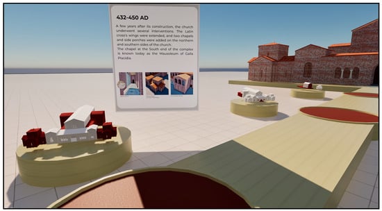
Figure 17.
Activation of pop-up information by entering the trigger zone.

Figure 18.
Schematization of the VR experience: (a) Starting point: the user position on the red circle to trigger the animation showing the first construction phase and the first textual pop-up; (b) The first phase 3D model appears; (c) Moving along the path and positioning on the red circles, new animations are triggered to show the correspondent phase; (d) A view of the final construction phase (end of the path) with the correspondent textual pop-up.
After the virtual environment and walkways were created, the virtual reality (VR) system was connected to enable an immersive review of the design using a head-mounted display (HMD). This allows users to explore the building’s exterior (Figure 19) and interior (Figure 20), examining the mausoleum and church in detail, which facilitates a better understanding of spatial relationships and scale. The primary outcome of this phase was the development of an interactive VR experience that enabled meaningful engagement with the digital reconstruction.

Figure 19.
Virtual Reality experience: construction phase III.
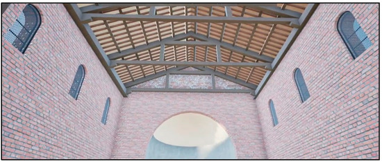
Figure 20.
Virtual Reality experience: View of the interior of the church (phase IV).
However, some challenges arose, including maintaining smooth performance and usability, managing the complexity of interactive components and animations, and addressing hardware limitations. While hardware constraints were present, they did not significantly affect the level of immersion achieved. A high-end VR headset (HTC Vive Pro 2, HTC, Taoyuan, Taiwan), equipped with a 4896 × 2448 pixel resolution and a 120 Hz refresh rate, was used to enhance visual rendering quality. Minor performance issues—such as occasional lags—were likely due to the complexity of the VR scene, which included multiple 3D models segmented into individual parts, numerous animations, and high-resolution textures accompanied by textual and image-based elements. Despite these minor issues, the overall quality and fluidity of the experience remained largely unaffected.
4. Discussion
Having described the methodology, we reflect on the technical outcomes. The workflow generated a series of 3D models representing four distinct construction phases of the Church of Santa Croce. By combining highly accurate survey data of today’s situation with digitized historical drawings, the models captured both the current state and hypothesized earlier configurations of the monument. Integrated into a VR environment, they allowed users to navigate through the church’s evolution via a timeline interface in a sort of 4D environment. The animated transitions between phases effectively communicated structural additions and losses, while contextual annotations provided support for interpretation.
Several practical challenges emerged during the implementation. Gaps in historical documentation required careful interpretation and reliance on architectural analogs. SketchUp’s limited presentation capabilities necessitated migrating to a more robust visualization platform, and performance constraints in VR arose due to scene complexity and high-resolution textures. An additional consideration is the choice of interaction paradigm for sequencing the phases. Our prototype utilizes discrete animations triggered at timeline hotspots to maintain narrative clarity; an alternative approach would be a continuous slider that allows users to smoothly interpolate between phases. Sliders can offer finer-grained control but require more complex algorithms and may confuse non-expert users. Exploring such alternatives is left for future work.
Despite these issues, the workflow demonstrates how heterogeneous datasets can be synthesized into a coherent digital context, making it applicable to heritage sites with stratified developments. Beyond reconstruction, the approach shows potential for monitoring, preventive documentation, and public engagement.
5. Conclusions
5.1. Original Aspects of This Work
This study advances digital heritage modeling by introducing a workflow that integrates geomatics-based data acquisition, phase-specific 3D modeling, and game-engine–based VR for interactive visualization. Methodologically, the innovation lies in three elements: (a) tool integration, combining laser scanning, UAV and terrestrial photogrammetry, GNSS and classical surveying, archival digitization, 3D modeling and a VR engine within a single pipeline; (b) explicit temporal segmentation of the monument’s construction history into discrete phases; (c) an immersive interaction design centered on an interactive timeline. Whereas previous projects often reconstruct a single historical state or provide linear walkthroughs, our approach allows users to explore successive building stages, triggering animations that add or remove structural components and presenting contextual information at key chronological milestones.
Concerning immersive qualities and user experience, the VR scene was tailored for this case: a timeline path with trigger points, pop-up notes linked to sources, and survey-based textures to keep phase changes legible in situ. Head-mounted display navigation supports both exterior and interior exploration. The lightweight CAD→VR pipeline improves accessibility for exhibitions and education by shortening the path from survey to deployment while retaining metric control. By situating the work at the intersection of geomatics, 3D modeling, and immersive VR, it responds to recent calls for dynamic, multi-state representations of cultural assets and contributes a distinctive narrative device—the timeline interface—to ongoing scientific discourse.
5.2. Suggestions for Future Directions
While the results support the viability of the proposed method, further validation across additional case studies and more extensive user testing would be necessary to assess its generalizability. Future research may also consider integrating HBIM approach and complementary datasets, such as material degradation indicators or structural performance metrics, to expand the analytical and interpretive potential of immersive digital environments in heritage applications. The integration of the HBIM approach across the entire process—as highlighted in the examples provided in the literature review [17,18]—would enable the use of an asset management tool capable of collecting and sharing historical documentation and archival data with various stakeholders according to semantic logic. In addition, a more in-depth analysis could enable the querying of BIM data within VR platforms, ensuring better interoperability between platforms. Advancements in software tools and visualization technologies—for instance including lighting and audio-visual content—are expected to further enhance the immersivity and realism of digital reconstructions and the VR experience. Improved texture mapping and material rendering can in particular contribute to higher fidelity representations, especially from the perspective of architectural historians. Collaborative workflows involving historians, restorers, architects, and visualization specialists may yield more contextually rich and historically grounded models.
An important step for improvement is the development of more rigorous reliability and validation protocols. Structured frameworks for classifying reconstructed elements according to their evidential support—distinguishing between documented, inferred and hypothetical components—should be adopted, alongside cross-validation strategies such as expert consultation, comparison with existing representations and peer-review protocols. Aligning these practices with international guidelines, such as the London Charter and the Seville Principles, will enhance transparency and trustworthiness. Embedding confidence metadata within the models and VR environments would allow users to discern the reliability of each modeled feature.
Beyond these methodological refinements, other avenues merit exploration. Interactive walkthroughs with collision detection could improve the realism of the VR experience by preventing users from passing through walls or floors and by enabling guided tours along predefined paths. Visualizing uncertainty through color coding, transparency or hatching could communicate the degree of evidential support behind each reconstructed element. Structured user testing should be designed to evaluate such interface variants and to gather feedback on usability, comprehension, and engagement from both experts and general audiences.
Finally, augmented reality (AR) and mixed reality (MR) technologies present another opportunity to extend the accessibility and educational value of our reconstructions. In contrast to VR, AR/MR apps can overlay historical data, 3D reconstructions and multimedia content directly onto the physical site during in situ explorations, while integration with structural-monitoring sensors could enable real-time assessments of building health and environmental conditions. That said, the platform used in this study—Twinmotion—focuses on immersive VR and does not natively support AR. To deliver the Santa Croce models in AR or MR, the models would need to be exported into an AR/MR-capable environment (for example, via Unity or Unreal Engine platforms using dedicated AR toolkits), and additional development work would be required to optimize geometry, to design the user interface, and to handle device-specific interactions. Exploring such a pipeline lies beyond the scope of this paper but represents a promising direction for future research.
Author Contributions
Conceptualization, Domenico Simone Roggio, Anna Forte and Gabriele Bitelli; methodology, Domenico Simone Roggio, Anna Forte, Sina Shokrollahi; software, Domenico Simone Roggio and Sina Shokrollahi; validation, Domenico Simone Roggio and Anna Forte; formal analysis, Anna Forte and Gabriele Bitelli; investigation, Domenico Simone Roggio, Anna Forte, Sina Shokrollahi; data curation, Domenico Simone Roggio and Gabriele Bitelli; writing—original draft preparation, Domenico Simone Roggio and Sina Shokrollahi; writing—review and editing, Domenico Simone Roggio, Anna Forte, Sina Shokrollahi, Gabriele Bitelli; visualization, Domenico Simone Roggio, Sina Shokrollahi; supervision and project administration, Gabriele Bitelli. All authors have read and agreed to the published version of the manuscript.
Funding
This research received no external funding.
Data Availability Statement
The datasets presented in this article are not readily available because they are part of an ongoing study.
Acknowledgments
This research originated from the SHELTER Project, funded by the European Union’s Horizon 2020 Research and Innovation Program under grant agreement no. 821282. For the realization of the survey conducted for the SHELTER project, the authors wish to thank the Superintendence of Archaeology, Fine Arts and Landscape (SABAP) of Ravenna, the Diocese of Ravenna and the Municipality of Ravenna. The VR implementation was partially realized in the framework of the AlmaAugmented project by the University of Bologna.
Conflicts of Interest
The authors declare that they have no conflicts of interest.
Correction Statement
This article has been republished with a minor correction to the Data Availability Statement. This change does not affect the scientific content of the article.
Abbreviations
The following abbreviations are used in this manuscript:
| GIS | Geographic Information System |
| DICAM | Department of Civil, Chemical, Environmental and Materials Engineering (University of Bologna) |
| ARPAE | Agenzia regionale per la prevenzione, l’ambiente e l’energia dell’Emilia-Romagna (Regional Agency for Prevention, Environment, and Energy of Emilia-Romagna Region) |
| VR | Virtual Reality |
| SHELTER | Sustainable Historic Environments hoListic reconstruction through Technological Enhancement and community-based Resilience |
| UAV | Unmanned Aerial Vehicle |
| GNSS | Global Navigation Satellite System |
| HBIM | Historic Building Information Modeling |
| CAD | Computer-Aided Design |
| HMD | Head-Mounted Display |
| AR | Augmented Reality |
References
- Al-Houdalieh, S.H.; Sauders, R.R. Building Destruction: The Consequences of Rising Urbanization on Cultural Heritage in the Ramallah Province. Int. J. Cult. Prop. 2009, 16, 1–23. [Google Scholar] [CrossRef]
- Fu, L.; Zhang, Q.; Tang, Y.; Pan, J.; Li, Q. Assessment of urbanization impact on cultural heritage based on a risk-based cumulative impact assessment method. Herit. Sci. 2023, 11, 177. [Google Scholar] [CrossRef]
- Ombeni, S.; Mbosha, D.; Mpyanga, S. Urbanization and Vulnerability of Architectural Heritage: The Case of Dar es Salaam CBD. Conservation 2021, 1, 216–227. [Google Scholar] [CrossRef]
- Güler Nakıp, G.; Żmudzińska-Nowak, M.; Ballice, G. The Neglected Modern Architectural Heritage: Analysis of Housing Estates in the Second Half of the 20th Century from İzmir, Turkey, Case Study Area. Buildings 2024, 14, 3337. [Google Scholar] [CrossRef]
- El-Hakim, S.F.; Beraldin, J.-A.; Picard, M.; Godin, G. Detailed 3D reconstruction of large-scale heritage sites with integrated techniques. IEEE Comput. Graph. Appl. 2004, 24, 21–29. [Google Scholar] [CrossRef] [PubMed]
- Salagean-Mohora, I.; Anghel, A.A.; Frigura-Iliasa, F.M. Photogrammetry as a Digital Tool for Joining Heritage Documentation in Architectural Education and Professional Practice. Buildings 2023, 13, 319. [Google Scholar] [CrossRef]
- Fascia, R.; Barbieri, F.; Gaspari, F.; Ioli, F.; Pinto, L. From 3D Survey to Digital Reality of a Complex Architecture: A Digital Workflow for Cultural Heritage Promotion. Int. Arch. Photogramm. Remote Sens. Spatial Inf. Sci. 2024, XLVIII-2/W4, 205–212. [Google Scholar] [CrossRef]
- Tytarenko, I.; Machado, J.; Pavlenko, I. Digitization of Architectural Heritage Objects Using Photogrammetry: Sumy Region Case Study. J. Eng. Sci. 2025, 12, E18–E28. [Google Scholar] [CrossRef]
- Santana Quintero, M.; Awad, R.; Barazzetti, L. Harnessing Digital Workflows for the Understanding, Promotion and Participation in the Conservation of Heritage Sites by Meeting Both Ethical and Technical Challenges. Built Herit. 2020, 4, 6. [Google Scholar] [CrossRef]
- Rodriguez-Garcia, B.; Guillen-Sanz, H.; Checa, D.; Bustillo, A. A Systematic Review of Virtual 3D Reconstructions of Cultural Heritage in Immersive Virtual Reality. Multimed. Tools Appl. 2024, 83, 89743–89793. [Google Scholar] [CrossRef]
- Rizvic, S.; Boskovic, D.; Bruno, F.; Petriaggi, B.D.; Sljivo, S.; Cozza, M. Actors in VR Storytelling. In Proceedings of the 2019 11th International Conference on Virtual Worlds and Games for Serious Applications (VS-Games), Vienna, Austria, 4–6 September 2019; pp. 1–8. [Google Scholar] [CrossRef]
- Günay, S. Virtual reality for lost architectural heritage visualization utilizing limited data. Int. Arch. Photogramm. Remote Sens. Spatial Inf. Sci. 2022, 46, 253–257. [Google Scholar] [CrossRef]
- Forte, A.; Alkhatib, Y.J.; Bitelli, G.; Malinverni, E.S.; Pierdicca, R. Geomatics and Metaverse for Lost Heritage Sites Documentation and Dissemination: The Case Study of Palmyra Roman Theatre (Syria). Virtual Archaeol. Rev. 2024, 16, 85–99. [Google Scholar] [CrossRef]
- Agnello, F.; Avella, F.; Agnello, S. Virtual Reality for Historical Architecture. Int. Arch. Photogramm. Remote Sens. Spatial Inf. Sci. 2019, XLII-2/W9, 9–16. [Google Scholar] [CrossRef]
- Kersten, T.P.; Skripnikova, E.; Deggim, S. Development of a Virtual Reality Application for a Historic Villa and Three Construction Phases. Int. Arch. Photogramm. Remote Sens. Spatial Inf. Sci. 2024, XLVIII-2/W4, 247–253. [Google Scholar] [CrossRef]
- Glazov, K.; Trebeleva, G.; Abornev, I.; Sakania, S.; Yurkov, V.; Yurkov, G. Three-Dimensional Reconstruction of the Early Christian Temples of the Roman Fortress of Pitiunt. Appl. Sci. 2024, 14, 4624. [Google Scholar] [CrossRef]
- Lin, G.; Li, G.; Giordano, A.; Sang, K.; Stendardo, L.; Yang, X. Three-Dimensional Documentation and Reconversion of Architectural Heritage by UAV and HBIM: A Study of Santo Stefano Church in Italy. Drones 2024, 8, 250. [Google Scholar] [CrossRef]
- Klapa, P.; Żygadło, A.; Pepe, M. 3D Heritage Reconstruction Through HBIM and Multi-Source Data Fusion: Geometric Change Analysis Across Decades. Appl. Sci. 2025, 15, 8929. [Google Scholar] [CrossRef]
- Marasco, A. Beyond Virtual Cultural Tourism: History-Living Experiences with Cinematic Virtual Reality. Tour. Herit. J. 2020, 2, 1–16. [Google Scholar] [CrossRef]
- Tini, M.A.; Forte, A.; Girelli, V.A.; Lambertini, A.; Roggio, D.S.; Bitelli, G.; Vittuari, L. Scan-to-HBIM-to-VR: An integrated approach for the documentation of an industrial archaeology building. Remote Sens. 2024, 16, 2859. [Google Scholar] [CrossRef]
- SHELTER Project. Available online: https://shelter-project.com/ (accessed on 16 June 2025).
- Sericola, M.; Agostinelli, E.R.; Ugolini, A. L’area archeologica di Santa Croce. Rischio e degrado come elementi per pianificare il futuro di un sito. In Monitoraggio e Manutenzione delle Aree Archeologiche: Cambiamenti Climatici, Dissesto Idrogeologico, Degrado Chimico Ambientale; Parco Archeologico del Colosseo: Roma, Italy, 2019. [Google Scholar]
- Ugolini, A.; Melandri, E.; Agostinelli, E.R.; Sericola, M.; Vandini, M.; Fiorentino, S. Managing Water Risks in Archaeological Sites: The Flooding of the Complex of Santa Croce in Ravenna. In Gli Effetti dell’Acqua sui Beni Culturali. Valutazioni, Critiche e Modalità di Verifica; Biscontin, G., Driussi, G., Eds.; Arcadia Ricerche: Venezia, Italy, Scienza e Beni Culturali; 2020; Volume 2020, pp. 163–174. ISBN 978-88-95409-24-5. [Google Scholar]
- Bitelli, G.; Barbieri, E.; Girelli, V.A.; Lambertini, A.; Mandanici, E.; Melandri, E.; Roggio, D.S.; Santangelo, A.; Tini, M.A.; Tondelli, S.; et al. The complex of Santa Croce in Ravenna as a case study: Integration of 3D techniques for surveying and monitoring of a historical site. In Proceedings of the Joint International Event 9th ARQUEOLÓGICA 2.0 & 3rd GEORES, Valencia, Spain, 26–28 April 2021; pp. 408–413. [Google Scholar] [CrossRef]
- Rosa, A.; Santangelo, A.; Tondelli, S. Investigating the Integration of Cultural Heritage Disaster Risk Management into Urban Planning Tools. The Ravenna Case Study. Sustainability 2021, 13, 872. [Google Scholar] [CrossRef]
- Ravenna Turismo. Available online: https://www.turismo.ra.it/en/culture-and-history/religious-buildings/church-santa-croce/ (accessed on 16 June 2025).
- Cassanelli, R.; Cirelli, E.; Crociati, E.; Civiletti, J.P.; David, M.; Fiorini, A.; Jäggi, C.; Pasquini, L.; Scaini, R. La Basilica di Santa Croce. Nuovi Contributi per Ravenna Tardoantica; Edizioni del Girasole: Ravenna, Italy, 2013; ISBN 1722-1374. [Google Scholar]
- Ricceri, G. Studi e Ricerche Nell’area di S. Vitale, Galla Placidia e Santa Croce in Ravenna; SGEditoriali: Padova, Italy, 1992. [Google Scholar]
- David, M. (Ed.) La Basilica di Santa Croce. Nuovi Contributi per Ravenna Tardoantica; Edizioni del Girasole: Ravenna, Italy, Biblioteca di Felix Ravenna; 2013; Volume 15, ISBN 978-88-7567-556-1. [Google Scholar]
Disclaimer/Publisher’s Note: The statements, opinions and data contained in all publications are solely those of the individual author(s) and contributor(s) and not of MDPI and/or the editor(s). MDPI and/or the editor(s) disclaim responsibility for any injury to people or property resulting from any ideas, methods, instructions or products referred to in the content. |
© 2025 by the authors. Published by MDPI on behalf of the International Society for Photogrammetry and Remote Sensing. Licensee MDPI, Basel, Switzerland. This article is an open access article distributed under the terms and conditions of the Creative Commons Attribution (CC BY) license (https://creativecommons.org/licenses/by/4.0/).