Article

The Toponym Co-Occurrence Index: A New Method to Measure the Co-Occurrence Characteristics of Toponyms

1
School of Management, Liaoning University of International Business and Economics, Dalian 110652, China
2
School of Geographical Sciences, Liaoning Normal University, Dalian 110629, China
*
Author to whom correspondence should be addressed.
ISPRS Int. J. Geo-Inf. 2025, 14(9), 343; https://doi.org/10.3390/ijgi14090343
Submission received: 24 June 2025 / Revised: 29 August 2025 / Accepted: 2 September 2025 / Published: 5 September 2025

Abstract

Toponym groups are fundamental units of quantitative spatial analysis of toponyms. Using suitable technical methods to investigate the spatial distribution and co-occurrence characteristics of these groups has significant implications for identifying cultural regions within geographical spaces and elucidating spatial differentiation and integration of regional cultural characteristics underlying toponyms. Existing research has mainly relied on traditional spatial distribution models such as standard deviation ellipse (SDE) and kernel density estimation (KDE) to analyse the characters used in toponyms. In addition, few quantitative studies exist on the co-occurrence of multiple types of toponym groups from the perspective of words used in toponyms. This study introduced methods, including the local co-location quotient, to propose a general framework for toponymic co-occurrence research and a new toponymic co-occurrence index (TCOI). Data from 64,981 village toponyms in Liaoning Province, China, were used to analyse spatial co-occurrence characteristics of five high-frequency two-character village toponym groups. In addition, two high-frequency single-character toponym groups and three low-frequency two-character toponym groups were used for verification, with a simultaneous comparison of the SDE and KDE methods. The findings indicated that: (1) the proposed general framework and TCOI effectively support toponymic spatial measurement and have good applicability and expansibility; (2) the TCOI enables a more accurate scientific assessment of co-occurrence characteristics of toponymic groups at different scales, thereby enhancing the technical level of toponymic spatial measurement; (3) the TCOI for Liaoning Province was 28.63%, indicating that toponym groups exhibited a partially integrated yet relatively exclusive spatial distribution pattern. The spatial differentiation patterns of rural toponym cultural landscapes in Liaoning Province provide a scientific basis for promoting cultural geography research and strengthening toponym protection.

1. Introduction

Toponyms—proper names given to places or geographical features that often reflect the history, culture, and characteristics of that location—can generally be divided into natural landscapes, humanistic landscapes, and symbols of desire, and they can involve the use of ancient or foreign names [1]. They often have distinct basic characteristics. First, positional in nature, they can serve as identifiable features for determining the specific geographical locations of other entities on the Earth’s surface. These characteristics include elements such as location, orientation, distance, and scope. Second, they comprise a social/historical component. The evolution of individual toponyms—i.e., the process of naming and renaming them—has invariably been influenced by prevailing social changes and historical realities, resulting in an evident social and historical imprint. Third, there is a locality component. Toponyms are defined by the natural and human geographical characteristics of a place and portray the historical context of development and evolution, reflecting distinctive local characteristics [2]. They are important symbols that characterise and reflect local cultural features and characteristics.
In contrast to urban toponyms, village toponyms are used in rural areas. Villages often convey greater richness and diversification in their historical and cultural information even with comparatively minor spatial and temporal changes. Village toponyms offer valuable insights into cultural heritage and clearly indicate cultural continuity. They also demonstrate a closer spatial-temporal mapping relationship with local culture, conveying the stability, representativeness, and detectability of spatial-temporal characteristics and connotations. Consequently, they can be used to analyse the spatiotemporal characteristics of local cultural features [3,4]. The study of village toponyms holds significant value in unveiling the historical evolution of rural society, fostering local cultural characteristics, and fortifying regional cohesion [5].
From the perspective of the spatial measurement of toponyms, high-frequency village toponyms pertain to those that demonstrate a comparatively high frequency of repeated use within a specific rural area. They have been shown to reflect the basic features of a region’s cultural landscape and can be used to map the basic background and linkages to regional cultural integration and conflict [6]. Detecting co-occurring features of high-frequency village toponyms helps to quantify the integration, attraction and exclusion attributes of local culture. This, in turn, helps reveal the characteristics of regional cultural landscapes. Furthermore, it has been demonstrated that this process can facilitate the identification of cultural types and delineation of regional cultural characteristics. In addition, it can clarify the direction of local culture cultivation, promote the creation of toponym cultural landscapes, and facilitate the comprehensive development of regional cultural and tourism industries [7].
The theoretical framework and methodology in the study of high-frequency village toponyms involve numerous disciplinary fields, including geography, history, linguistics, and sociology [8,9]. The theoretical framework primarily focuses on the origin, evolution, and classification of toponyms and their relationships with the natural environment and social culture [10,11,12]. The methodology combines qualitative and quantitative research and employs a variety of technological methods to conduct in-depth analyses [13,14].
In recent years, significant progress has been made in spatial measurement research related to high-frequency village toponyms. The existing literature has primarily concentrated on three principal domains. First, the spatial distribution characteristics of toponymic cultural landscapes have been considered. Using GIS technology, researchers have employed kernel density estimation (KDE) and spatial autocorrelation methods to analyse the spatial distribution characteristics of ancient towns [15], traditional villages [16,17], and specific regional toponyms [18,19,20]. The objective of this type of analysis is to reveal the implicit geographic regularities and cultural characteristics that govern the distribution of toponyms. Second, the analysis of factors influencing toponymic cultural landscapes has been a focus. Researchers have explored the formation and mechanisms of changes in toponymic cultural landscapes from various perspectives. These include the analysis of genetic information chains [21,22] and exploration of spatial patterns [19,23], as well as innovation in the construction methods concerning geo-informatic graphs of toponymic cultural landscapes [24]. Analyses of cultural, spatial, and temporal characteristics [12,25], examinations of toponymic cultural landscapes in political districts [26], and summaries of the human geographical characteristics of Chinese toponyms [27] have been undertaken with the aim of gaining deeper insight into the causes and influencing factors of toponymic cultural landscapes. Third, research on the inheritance and protection of toponymic cultures has attracted considerable attention from multiple perspectives, including the use of toponyms and linguistics [28,29], their connection with urban development [30,31], their integration and the application of GIS technology [32,33,34], the methodology of toponym cultural information mapping and quantitative analysis [35], and their close connection with national cultures [36,37]. Relevant studies have emphasised the fundamental value of toponyms in history, culture, and society and discussed the effective protection and preservation of toponymic culture in the context of urbanisation and modern development.
In addition, the representative research related to Liaoning Province has progressed in its regional empirical research, theoretical discussion, method innovation, and topic mining. The study area includes administrative areas such as Dalian [38], Chaoyang [39], Panjin [40] city, and Liaoning Province [41], as well as special natural units with the theme of islands [42]. Regarding the research paradigm, a pluralistic pattern of traditional textual criticism [43], multidisciplinary integration, and critical theory [41] has been formed. In terms of research methods, digital humanities technology represented by GIS has become mainstream [44], promoting the development of research to spatialisation and quantification. The study focuses on the cultural connotations of individual toponyms and explores in-depth the complex dimensions of power operation, social justice, and the economic value behind it [45].
A general overview of the extant literature reveals many studies that have focused on the characteristics of toponyms in the fields of toponym cultural landscape and toponym spatial analysis, whereas a paucity of research was found on toponymic vocabulary and even less examining the co-occurrence characteristics of high-frequency toponyms. Furthermore, the technical methods employed in the relevant research are relatively limited, with the most widely representative techniques primarily comprising the compilation of thematic maps of toponyms, the KDE method, and other methods to illustrate and measure the distribution characteristics of toponyms. While these methods can well reflect the spatial distribution and agglomeration characteristics of toponyms, they lack mining and measurement indicators for deeper phenomena such as toponym co-occurrence, integration, and exclusion. Notably, the paucity of application demonstration scenarios is particularly striking, with research on the spatial measurement of toponyms in Liaoning Province exhibiting a pronounced absence of such scenarios. Based on the above considerations, this study aimed to focus on the following matters. First, relevant data concerning high-frequency two-character toponym groups in Liaoning Province were mined based on toponym big data and spatial visualisation. Second, the local co-location quotient (LCLQ) was applied to construct a toponymic co-occurrence index (TCOI). Third, the spatial co-occurrence characteristics of the high-frequency village toponym groups in Liaoning Province were detected using the new GIS technology of exploratory spatial data analysis. Lastly, compared with the traditional KDE and standard deviation ellipse (SDE) methods, the advantages of TCOI are verified. This study aims to further expand the frontier field of toponym spatial measurement research, design a technical framework and co-occurrence measurement index to facilitate toponym co-occurrence feature quantification, and provide theoretical reference and practical basis for the protection and construction of historical toponym cultural landscape.

2. Study Area and Data Sources

2.1. Regional Overview

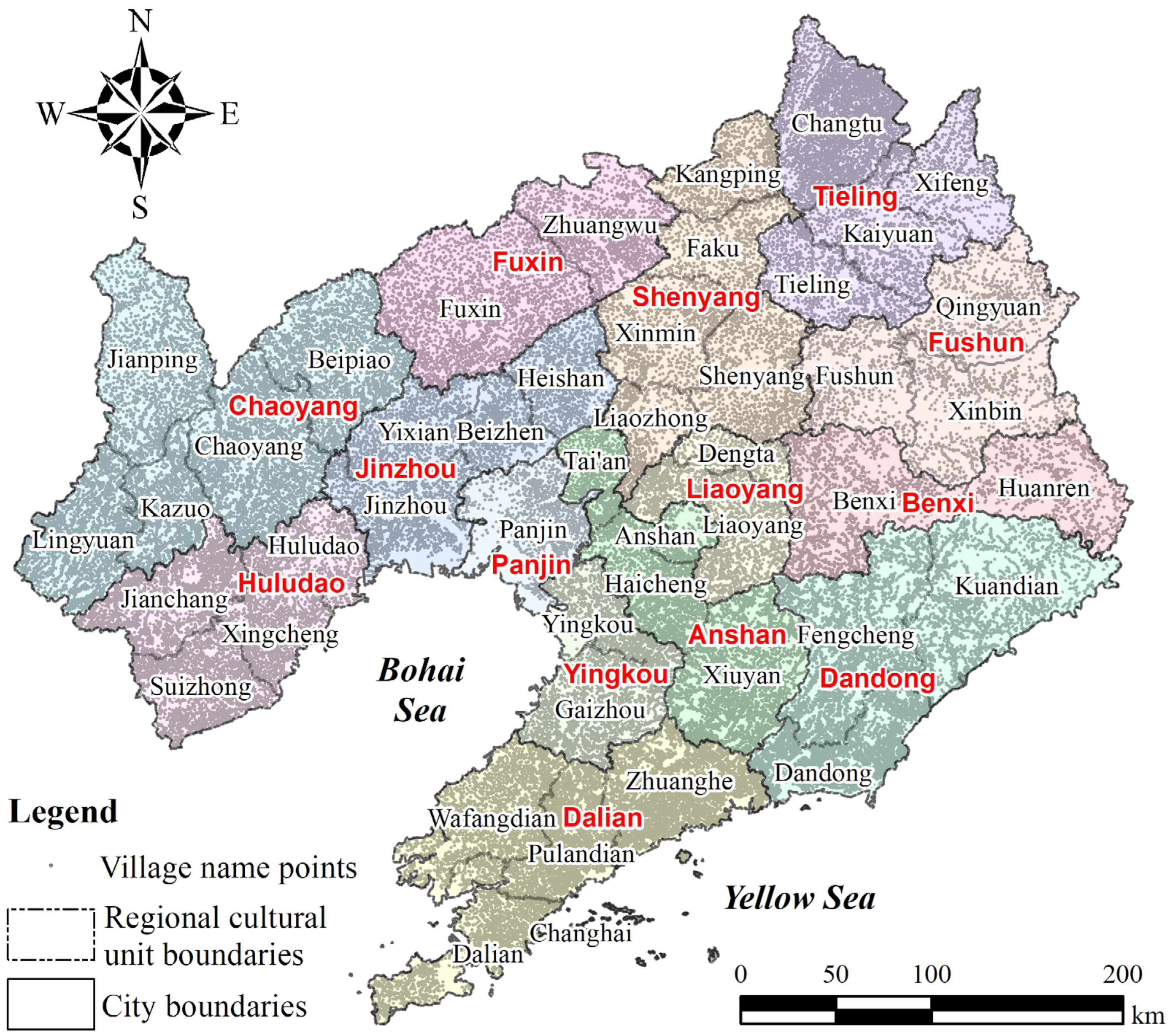
Liaoning Province is located in the southern part of Northeast China and has an area of 147,000 km2 of land and coastal islands. The Seventh National Population Census of the People’s Republic of China (2020 Chinese Census) documented a permanent population of 41.82 million. Liaoning Province comprises 14 prefecture-level cities, 59 municipal districts, 16 county-level cities, 17 counties, and eight autonomous counties, with a total of 100 county-level administrative units (Figure 1). In accordance with the established tradition and prevailing practice in relation to the geographical comprehensive division of Liaoning Province, the formation and evolution of toponyms have been given due consideration, along with the spatial differences in the geographical environment, historical culture, social economy, and other pertinent factors. To explore the regional differences in the cultural landscape of toponyms in the province, 46 relatively independent regional cultural units (Figure 2) were formed by merging county and city units. These units were used to detect the county-scale bandwidth (as set out in Section 3.3).
The geographical situation of Liaoning Province has rendered it a unique region in China, where the cultures of the north and south converge, intertwine, and bond. Liaoning Province was one of the earliest developed areas in Northeast China. The region is characterised by a variety of distinct cultural traditions, including the Central Plains culture in Western Liaoning, Guandong culture in Central Liaoning, and Qilu culture in Eastern Liaoning. The historical evolution of Liaoning, as evidenced by its development and construction, is indicative of the distinctive characteristics of multiethnic mixed areas. The current distribution of ethnic groups in the territory is as follows: those of Manchu ethnicity primarily inhabit eastern Liaoning, those of Mongolian ethnicity mainly live in western Liaoning, those of Korean ethnicity mainly live in central Liaoning, and those of Han ethnicity predominate in western, northern, central, and southern Liaoning. In consideration of the genesis of contemporary toponyms, the toponyms of Liaoning prefectures and counties are predominantly derived from the appellations of government offices, specifically the ‘separation of Banner and civilian’. It was a governing system in the Qing Dynasty (1644–1912), which distinguished the ‘Banner People’ (ethnic groups including Manchu, Mongol, and Han under the Eight Banners system) from ‘civilian’ (primarily Han and other ethnic groups), administering them through separate systems. The toponyms of towns and villages below prefectures and counties are principally derived from the occupational, developmental, competitive, settlement, and reproductive activities of multiethnic residents across various temporal periods [46].

2.2. Data Sources and Pre-Processing

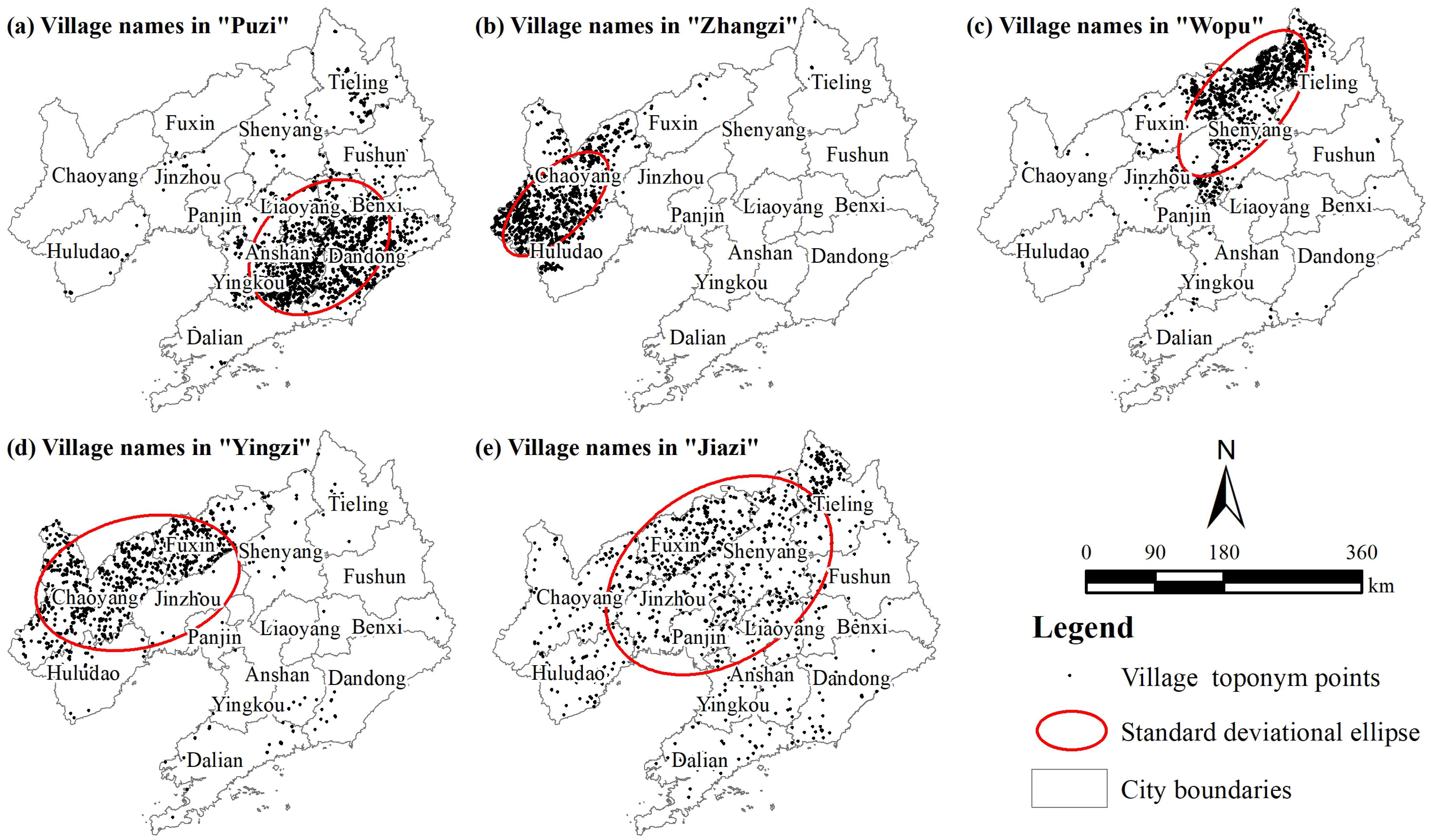
This study used the Baidu platform (https://map.baidu.com/, accessed on 5 March 2025) village toponym (BB80 category) point of interest (POI) data. The data points were obtained in late December 2023, and 64,981 ‘village-level toponyms’ in the province were collated. The GeoSharp1.0 tool was used to convert the POI data from ‘Mars coordinates’ to ‘WGS84’ coordinates. Subsequently, in the ArcGIS environment, the converted coordinates were used to create GIS vector points for spatial visualisation. To address the requirements for research and mapping, the UTM Zone 51N projected coordinate system was set up to construct a basic GIS database of village toponyms in Liaoning Province, which included 64,981 point objects (Figure 2). This study analysed the names of 64,981 villages using a word cloud tool (https://design.weiciyun.com/, accessed on 23 March 2025.) to perform word frequency analysis and extract two-character compound toponyms with relatively clear meanings. Five two-character high-frequency village toponym groups with more than 1000 occurrences, including Puzi (1815 times), Zhangzi (1295 times), Wopu (1173 times), Yingzi (1066 times), and Jiazi (1060 times), were selected as the basic objects for the spatial econometric analysis of toponyms (Figure 3).
The toponym Puzi appeared 1815 times (Figure 3a), making it the most frequently used two-character toponym in this province. The term Puzi originally emerged in connection with military defence. In ancient times, defensive structures were built at strategic locations, transportation hubs, and around villages to repel foreign invaders and prevent bandit raids. These structures, referred to as Pu structures, typically featured tall thick walls, watchtowers, and arrow towers, providing residents with shelter during times of turmoil. Over time, this led to the naming of the surrounding villages as Puzi villages. When a family settled in a specific Puzi, to distinguish it from neighbouring families’ Puzi, they would prefix the name with their family surname, such as Liujiapuzi or Lijiapuzi. Puzi toponyms are primarily concentrated in the eastern region of Liaoning Province.
The toponym Zhangzi appeared 1295 times (Figure 3b), with a usage frequency second only to that of Puzi toponyms. The toponym Zhangzi is believed to be derived from Zhangzi, which is said to have referred to structures with defensive functions against wild beasts. Inhabitants of the western mountainous regions and remote areas of Liaoning Province constructed rudimentary barriers around their dwellings using firewood, straw, and trees to protect against wild animal attacks, with more robust Zhangzi also serving a defensive function against bandits. The majority of Zhangzi villages are prefixed with surnames, such as Liuzhangzi and Chen zhangzi. Zhangzi toponyms are concentrated in the western Liaoning region, exhibiting a strong correlation with the area’s historical period, which is characterised by mountainous terrain, abundant wildlife habitats, and significant historical developments. This phenomenon can be considered a distinctive aspect of local toponym culture.
The toponym Wopu appeared 1173 times (Figure 3c), indicative of frequent use in Liaoning Province. Originally, Wopu referred to semi-underground dwellings that were well-insulated and suitable for habitation in cold regions during the winter. The toponym Wopu reflects the wisdom of early residents in selecting appropriate living arrangements based on local natural conditions, specific residential cultures, and living customs. Many of the Wopu toponyms in Liaoning Province were related to immigrants who came from northern China to the northeastern region via Shanhaiguan Pass during the 19th and early 20th centuries to engage in reclamation (Chuangguandong). To address housing issues, the immigrants built convenient, warm, wind- and rain-proof, snow bunker-like accommodation. Based on Wopu, these toponyms have become important symbols of immigrant culture in terms of demonstrating the development and evolution of simple settlements into villages of a certain scale and social structure, reflecting the development process of social settlements in the distribution area of toponyms, from dispersion to settlement, and from simple to complex forms.
The toponym Yingzi appeared 1066 times (Figure 3d) and typically referred to ancient military encampments. In Liaoning Province, villages and towns named Yingzi were originally military encampments dating from Mongol times or the late Qing Dynasty. Some locations, due to their strategic importance, became sites for military encampments and troop stationing, referred to as Ying. Subsequently, owing to a combination of factors, the military presence may have been withdrawn, and some individuals settled in these former encampment sites, gradually forming villages. Over time, toponyms evolved and eventually became known as Yingzi. The toponym Yingzi was commonly placed after surnames, such as Lijiayingzi or Zhangyingzi. The meaning of the term suggests that Yingzi locations were often situated along major transportation routes, in strategic locations, or near water sources as these areas were of significant geographical importance and were suitable for military encampment, with relatively favourable conditions for survival and living.
The toponym Jiazi appeared 1060 times (Figure 3e). Jiazi referred to a place where a family with specific blood ties resided together, often prefixed by the family name (surname), reflecting the traditional Chinese societal characteristics of family-based settlement patterns. Such patterns highlight the cohesion and continuity of family ties, as seen in examples such as Zhangjiazi and Lijiazi. A social structure centred on family units has, to some extent, contributed to the stability and development of local societies. Toponyms containing the toponym Jiazi from different regions may exhibit unique cultural characteristics. Jiazi toponyms are widely distributed in Liaoning Province.

3. Research Route and Technical Methods

3.1. Research Route

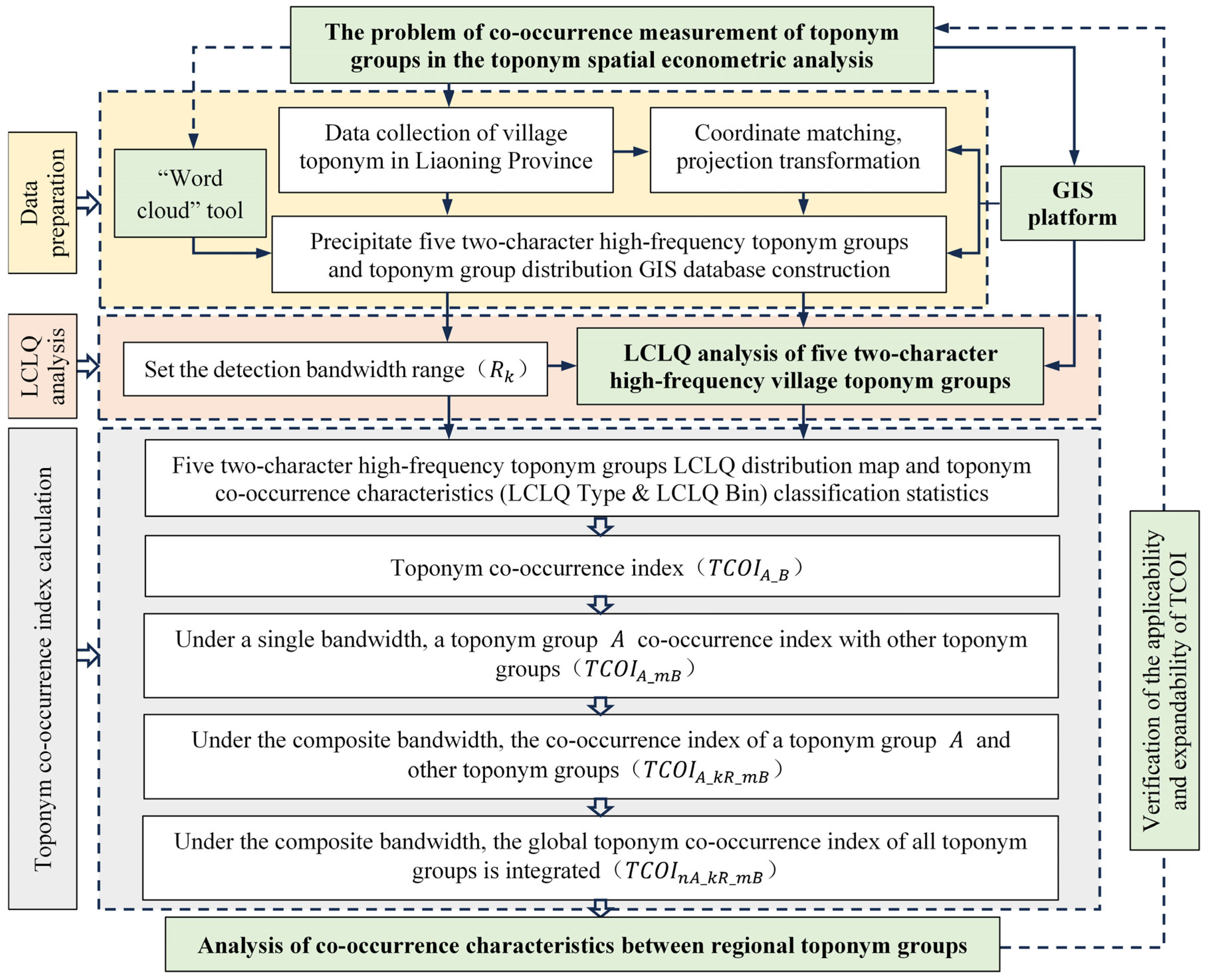
In response to the limited research on the co-occurrence of toponyms in toponym spatial econometric analysis, the aim of this study was to design a feasible research framework, construct a TCOI, introduce appropriate advanced technical methods, and verify the feasibility of technical methods and the TCOI using five high-frequency village toponym groups in Liaoning Province as examples. The fundamental research approach is illustrated in Figure 4.

3.2. The LCLQ Method

Co-location quotients (CLQs) are derived from economic location quotients and utilised on GIS platforms to measure the spatial association or local patterns of location synergy between two types of point elements. In 2011, Leslie et al. [47] proposed the concept and measurement principles of CLQs to measure the spatial association between two types of point elements across a regional scale. These quotients are called global colocation quotients (GCLQs). To accurately measure the co-location relationships within local areas of the study region, to more precisely detect the spatial association between the two types of point elements, and to provide decision-makers with more refined support, Cromley et al. [48] proposed the LCLQ in 2014 based on global co-location analysis. The LCLQ has been demonstrated to reveal multi-scale local spatial associations between two types of point elements within a defined neighbourhood range (bandwidth). The application of this proposed conceptual framework was undertaken given its clear delineation of geographical significance, which renders it pertinent to address specific challenges, such as regional coordination, spatial balance, and spatial conflicts. The efficacy of this approach has been demonstrated in a variety of fields, including urban planning [49], work-residence balance [50,51], crime behaviour research [52], industrial integration [53], and urban fire risk [54]. Concurrently, established GIS platforms, such as ArcGIS Pro, have been shown to enhance the performance of these co-location analysis tools.
The basic working principle is as follows. Within a certain range of research, there are two toponym groups: A and B . When studying the spatial proximity of the toponym A i on a specific point i , the following situations are presented: when the toponym A i on a specific point i appears and there are more group B toponyms around it, this means that group B toponyms have the characteristics of co-location for group A toponyms, reflecting clear integration between toponyms; when the toponym A i on a specific point i appears and there are fewer group B toponyms around it, this means that group B toponyms have the characteristics of an isolated location for group A toponyms, reflecting clear mutual exclusion between the toponyms (Figure 5 and Table 1).
The various formulas for the L C L Q are as follows:
L C L Q A i B = N A i B N B / ( N 1 )
N A i B = j = 1 ( j i ) N w i j f i j j = 1 ( j i ) N w i j , ( j i )
w i j = e x p 0.5 × d i j 2 d i b 2
In Formula (1), L C L Q A i B denotes the degree to which group B POIs are attracted by type A POIs. N B is the total number of group B cases in the study area. N is the total number of A and B   points included in the analysis of the study area. N B / ( N 1 ) denotes the proportion of group B elements in the nearest neighbour of group A elements in a random state. When L C L Q > 1, the relevant elements and neighbouring elements often appear together in the region, and the two groups of elements tend to merge. When L C L Q = 1, the distribution of the two groups of elements in the region is random and independent, and there is neither an aggregation nor an exclusion trend. When L C L Q < 1, the elements of interest and neighbouring elements tend to be spatially separated.
In Formula (2), N A i B is the weighted average value of the number of adjacent class B points in the A i neighbourhood of the A element. f i j represents a binary variable indicating whether j is a point in the group B element, being 1 if it is and 0 if it is not.
In Formula (3), w i j indicates the weight of point j , which reveals the importance of j to the i th A element. d i j denotes the distance between the points of the i th A element and the point j . d i b denotes the bandwidth distance near the i th A element A. L C L Q A i B is based on the distance decay function, which can make the elements closer to the target elements have greater weight in the calculation than the elements farther away. It can be based on Gaussian or bi-square kernels and is specified in the local weight scheme parameters. Formula (3) is a Gaussian function. The core idea is to assign a weight to each adjacent element in the study area. The closer the distance, the greater the influence of adjacent elements on the elements of interest, whereas, with further distance, the influence of adjacent elements on the elements of interest is less.
In terms of L C L Q A i B , a validity test (p value) was used to calculate whether there was statistical significance in the obtained synergistic location quotient. If the p-value was small (less than 0.05), the actual CLQ of the element was statistically significant. The default value of the ArcGIS Pro 3.3 tool is 99 permutations. With an increase in the number of permutation tests, the accuracy of the calculated p-values improved. The number of permutation tests was specified according to factors such as accuracy, calculation speed, and problem attributes.

3.3. Setting the Detection Bandwidth (R)

As shown in Figure 5, when examining the spatial proximity of the toponym A i on a specific point i in relation to the number of group B toponyms N A i B , the spatial neighbourhood, that is, the bandwidth (the R value) or the geospatial scale of geographical concern is an important factor. ArcGIS Pro 3.3 software provides three methods for specifying bandwidth: first, specifying the same spatial distance range, which means that denser areas will have more points considered in the analysis than sparser areas; second, the K-nearest method, which ensures that each neighbourhood contains the same number of adjacent features for each feature; and third, specifying the spatial connectivity matrix created by the generated spatial weight matrix tool. This study adopted the first method based on multiple factors, such as the characteristics of the co-occurrence of toponyms, the spatial scope of the study, and the number of sample points in the toponym group, and determined the bandwidth R value that met different detection needs through calculations. The bandwidths involved were as follows.
(1)
The global scale co-occurrence characteristic detection bandwidth ( R 1 ). The global scale was determined based on the 147,000 km2 global area of Liaoning Province and combined with the geographical boundaries of the province’s land area. Based on the geographical measurements shown in Figure 2, the straight-line distance from the southernmost to the northernmost point of the province was approximately 610 km, and the straight-line distance from the easternmost to the westernmost point was approximately 600 km. The bandwidth R -value was calculated to be 650 km to ensure that all toponym groups within the neighbourhood range of the province-wide detection were included in the analysis.
(2)
The prefecture-level city-scale co-occurrence characteristics detection bandwidth ( R 2 ). Liaoning Province includes 14 prefecture-level cities. Detecting the spatial co-occurrence between toponym groups at the prefecture-level city scale is an important administrative scale for the application of the detection results to cities. The following formula is used:
R   = S p l c / π
where R p l c is the radius of the equal-area circle area of each prefecture-level city, and S p l c is the area of land jurisdiction of the prefecture-level cities. Based on the calculation of the radius of the equal-area circle of the 14 prefecture-level cities, the average value of the 14 prefecture-level cities was 56.79 km, and the nearest integer of 60 km was taken as the prefectural city-scale co-occurrence characteristic detection bandwidth.
(3)
The regional cultural unit co-occurrence characteristic detection bandwidth ( R 3 ). Based on these 14 prefecture-level cities, Liaoning Province was further divided into 46 regional cultural units (Figure 2). Detecting co-occurrence features between toponym groups at the regional cultural unit spatial scale not only yields more precise detection results but also has potential applications in the construction of county-level toponym cultural landscapes. Using the same method for determining the co-occurrence feature detection bandwidth at the prefecture-level city scale, the average radius of the equal-area circles for the 46 regional cultural units was calculated to be 31.17 km. A rounded value of 30 km was selected as the regional cultural unit-scale co-occurrence feature detection bandwidth.

3.4. Construction of the TCOI

Based on a focused examination of the five toponymic groups and using the three previously identified spatial scales, and considering the need for a new method that provides a clear demonstration of co-occurrence, a generic TCOI was constructed. The process was as follows. It is assumed that n toponym groups are included in the co-occurrence feature detection in the study area, and each toponym group has i toponyms of different numbers. Then, select the detected bandwidth values R 1 , R 2 , …, R k ; then, select a toponym group A , where any toponym is A i ; and then, detect the co-occurrence relationship between A i and other toponym groups B 1 , B 2 , …, B m ( m = n 1 ).
(1)
The TCOI ( T C O I A _ B )
Under the premise of a single fixed bandwidth, the co-occurrence index of a toponym group A and another toponym group B in the study area was determined. The formula is as follows:
T C O I A _ B = S U M A L C L Q   B i n = 0 S U M A × 100 %
The corresponding relationship between L C L Q   B i n and the co-occurrence location characteristics is shown in Table 1; the values can be obtained from the return values of the co-occurrence location analysis. S U M A L C L Q   B i n = 0 is the number of toponyms in the toponym group A where L C L Q   B i n equal to zero, while S U M A represents the total number of toponyms in toponym group A . The co-occurrence characteristics T C O I A _ B of the two types of toponym groups under a single fixed bandwidth are the basic characteristics of toponym co-occurrence.
(2)
The single bandwidth TCOI ( T C O I A _ m B )
To determine a single fixed bandwidth, the co-occurrence index of a toponym group A and other toponym groups B 1 , B 2 , …, B m in the study area was determined. The calculation of T C O I A _ m B was divided into four steps.
The first step was to determine the toponym co-occurrence attributes ( T C O A A _ m B ) between a toponym group A and the other toponym groups, that is, the number of toponyms with different synergistic location types. Considering a toponym group A and other m as corresponding to B toponym groups, there were no significant co-occurrence attributes in TCOIA_B (i.e., L C L Q   B i n was 0). This study determined that, if there was one L C L Q   B i n equal to zero, this was a significant co-occurrence attribute. Using the local co-location analysis tool provided by ArcGIS Pro 3.3, the co-location characteristics of A i and the corresponding B 1 toponym groups were detected, and the co-occurrence characteristics detection results were counted as the co-occurrence characteristic values of A i _ B 1 _ L C L Q   B i n . The co-occurrence eigenvalues of A i and the corresponding B 2 , …, B m toponym groups, A i _ B 2 _ L C L Q   B i n , …, A i _ B m _ L C L Q   B i n were calculated successively. The aggregation formula for T C O A A _ m B is
T C O A A _ m B = A i _ B 1 _ LCLQ   Bin × A i _ B 2 _ LCLQ   Bin × × A i _ B m _ LCLQ   Bin
When T C O A A _ m B = 0, significant co-occurrence characteristics were considered to exist between a toponym group A and the other m toponym groups.
The second step was to calculate the maximum toponym co-occurrence index ( T C O I A _ M B ). Under the premise of a single fixed bandwidth, the maximum TCOI ( T C O I A _ M B ) of a toponym group A and another m corresponding to a toponym group B was determined using the following formula:
T C O I A _ M B = S U M T C O A A _ m B = 0 S U M A × 100 %
Here, S U M T C O A A _ m B = 0 was the number of toponyms in the toponym group where T C O A A _ m B equals zero, while S U M A represents the total number of toponyms in toponym group A .
The third step was to calculate the co-occurrence correction coefficient ( λ ). The co-occurrence characteristics between toponym group A and other toponym groups were computed using the product method in Formula (6). However, this calculation does not account for the difference in the number of toponyms where each multiplicative term equals zero when multiplying A i _ B m _ L C L Q   B i n values. This phenomenon obscures variations in co-occurrence levels among distinct toponym groups, resulting in an overestimation of TCOI. In accordance with the fundamental logic of toponym group co-occurrence, the ideal scenario in which T C O A A _ m B equals zero was achieved was realized by multiplying the product terms in which all A i _ B m _ L C L Q   B i n values of m toponym groups are zero. Nevertheless, the probability of all values being zero was exceptionally low. In most cases, one or several A i _ B m _ L C L Q   B i n values were equal to zero. In light of these observations, a co-occurrence correction coefficient, designated as λ , was introduced. The calculation of this coefficient was outlined as follows:
λ = S U M A i _ B m _ L C L Q   B i n = 0 m × S U M T C O A A _ m B = 0 m
Here, m was the number of co-occurrence toponym groups of toponym group A , S U M A i _ B m _ L C L Q   B i n = 0 was the total number of toponyms in which all L C L Q   B i n in A i _ B 1 _ L C L Q   B i n , A i _ B 2 _ L C L Q   B i n , …, A i _ B m _ L C L Q   B i n were equal to zero. Obviously, there was λ ≤ 1, and the greater the value of λ , the greater the degree of co-occurrence between toponym groups.
The fourth step was to calculate the TCOI of toponym group A and other m toponym groups ( T C O I A _ m B ). Under the premise of a fixed bandwidth, T C O I A _ m B was calculated using the following formula:
T C O I A _ m B = λ   ×   T C O I A _ M B
Here, the interval of T C O I A _ m B was [0, 100%]. The larger the value, the stronger were the co-occurrence characteristics between a toponym group A and the other m toponym groups under the bandwidth; conversely, the smaller the value, the stronger the exclusion characteristics.
(3)
The composite bandwidth TCOI ( T C O I A _ k R _ m B )
Under the premise of a composite multi-bandwidth R 1 , R 2 , …, R k , the TCOI ( T C O I A _ k R _ m B ) between a toponym group A and the other toponym groups B 1 , B 2 , …, B m was determined based on the following formula:
T C O I A _ k R _ m B = ( T C O I A R 1 m B 2 + T C O I A R 2 m B 2 + + T C O I A R k m B 2 ) / k 2
Here, the interval of T C O I A _ k R _ m B was [0, 100%]. The larger the value of T C O I A _ k R _ m B , the stronger the co-occurrence of the toponym group A with the other toponym groups, indicating that the toponym group belonged to a geospatial wide-area toponymy that reflected common toponymic cultural characteristics and strong toponymic cultural integration. The smaller the value of T C O I A _ k R _ m B , the stronger the exclusivity between the selected group of toponyms of interest and the other groups of toponyms, indicating that they belonged to geospatially localised toponyms, reflecting the individuality of the cultural characteristics of these toponyms and the geographical uniqueness of toponymic culture.
(4)
The global TCOI ( T C O I n A _ k R _ m B )
The composite multi-bandwidth R 1 , R 2 , …, R k was used to enable a comprehensive examination of n toponym groups in the region to construct a global toponymic co-occurrence index ( T C O I n A _ k R _ m B ), using the following formula:
T C O I n A _ k R _ m B = ( T C O I A 1 k R m B 2 + T C O I A 2 k R m B 2 + + T C O I A n k R m B 2 ) / n 2
Here, the interval of T C O I n A _ k R _ m B was [0, 100%]. The larger the value of T C O I n A _ k R _ m B , the stronger the co-occurrence between the n types of toponym groups in the entire domain, and, conversely, the smaller the value, the stronger the exclusion characteristics between the toponym groups.

4. Result Analysis

4.1. Multi-Bandwidth LCLQ Detection Results for the Toponym Groups

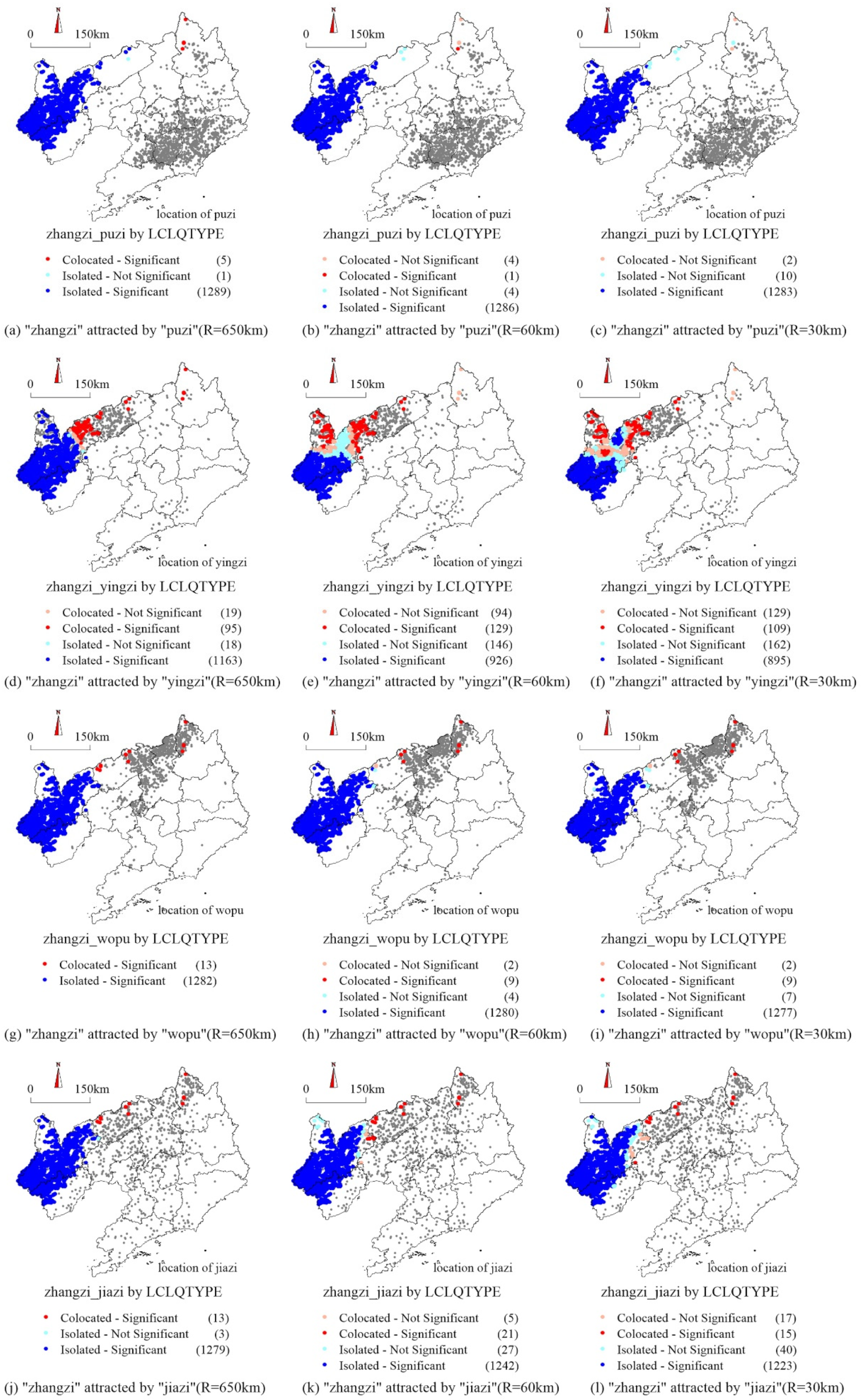
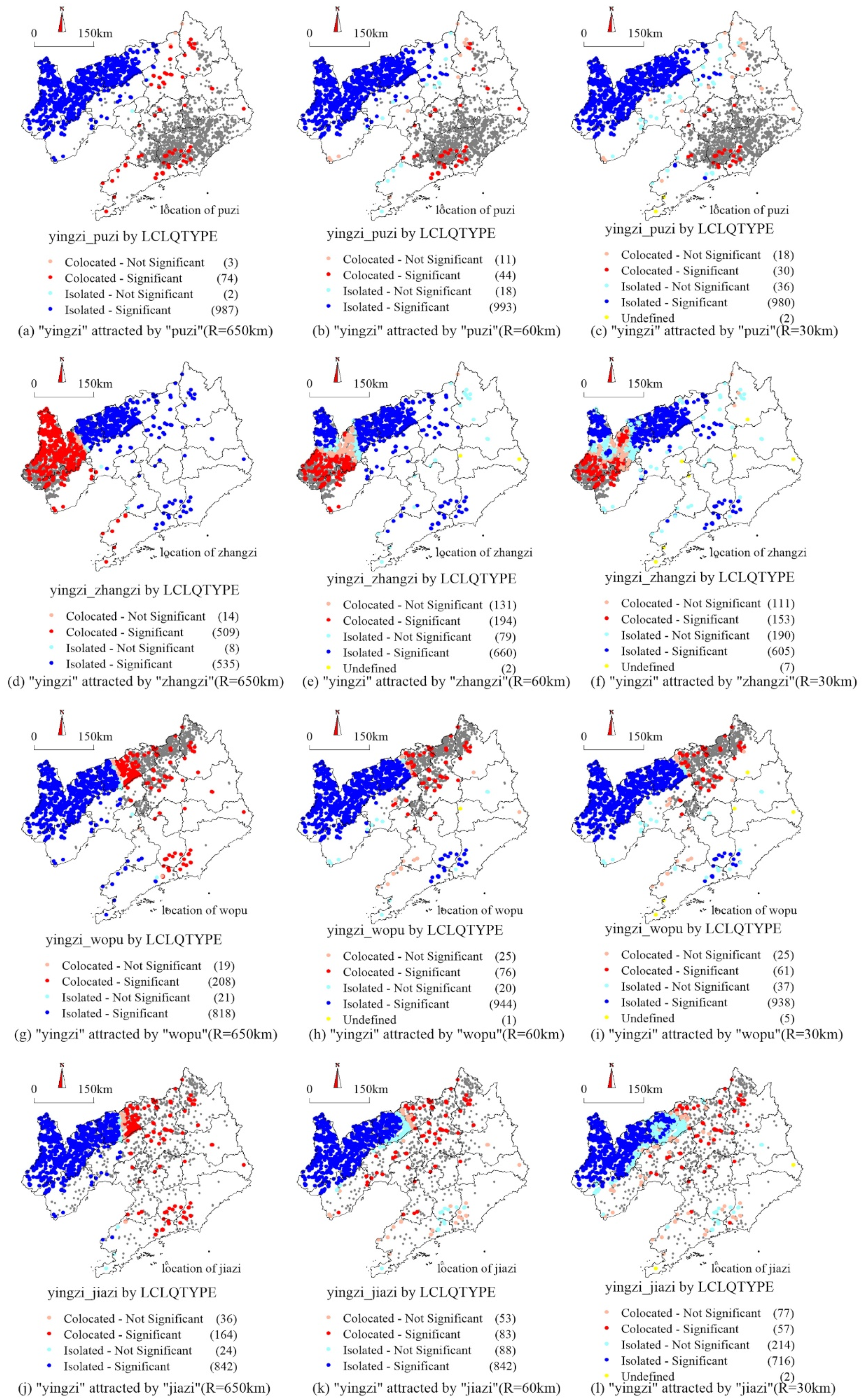
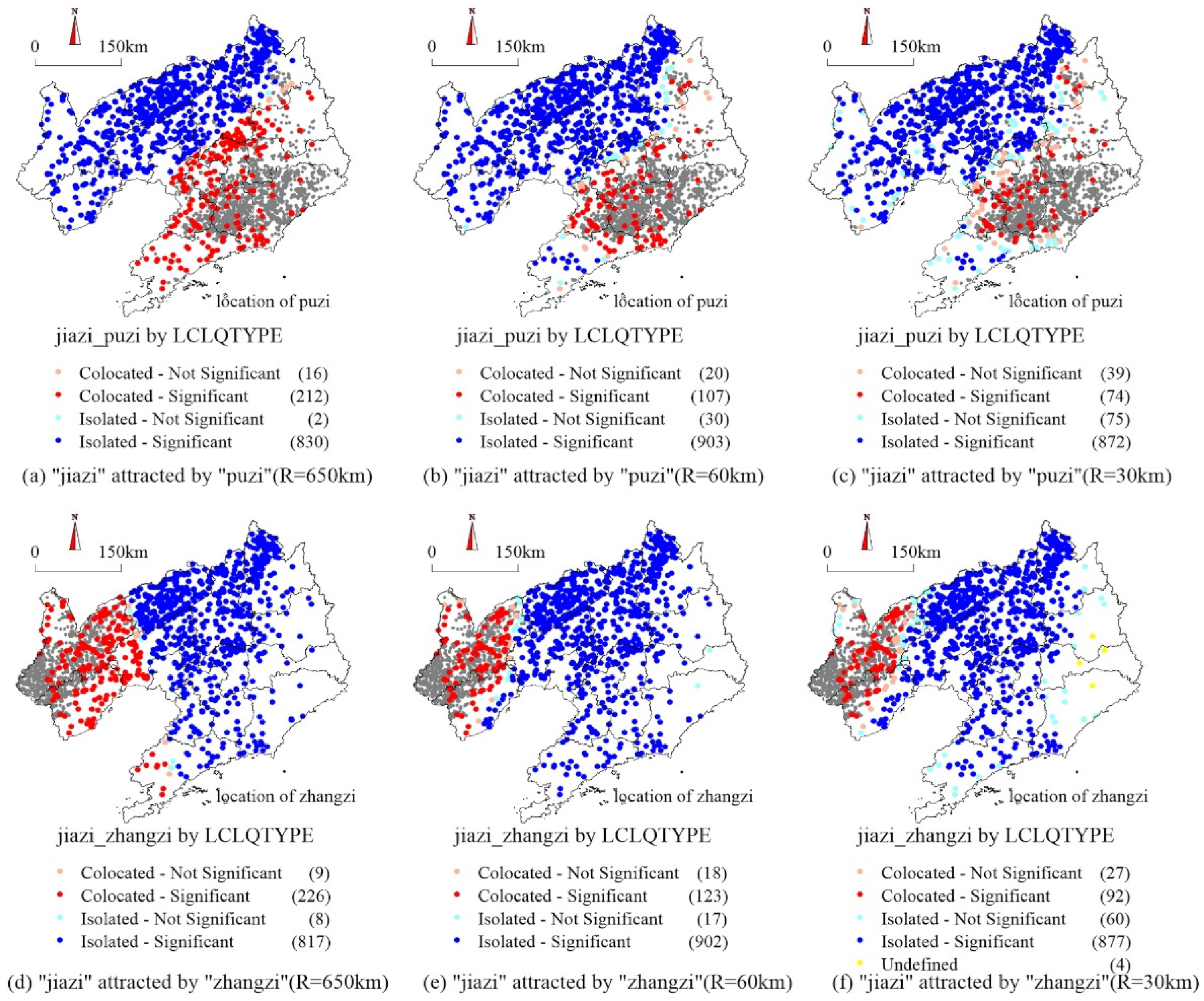
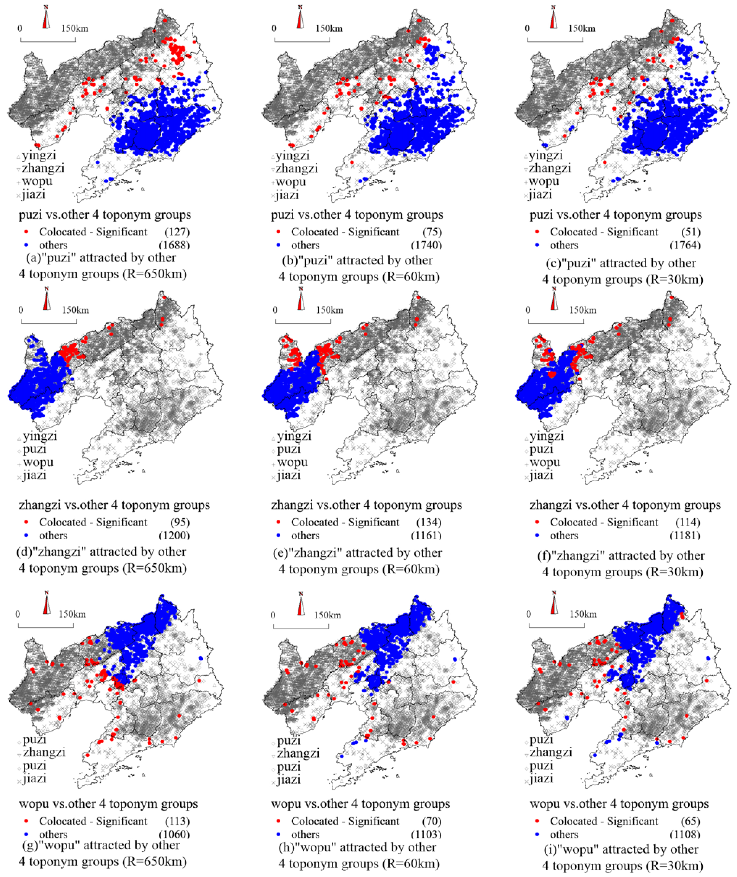
Based on the research plan outlined in Section 3.1, utilising the research methods described in Section 3.2, and according to the bandwidth values presented in Section 3.3, a local collaborative location analysis tool integrated into ArcGIS Pro 3.3 was employed. The toponym groups Puzi, Zhangzi, Wopu, Yingzi, and Jiazi were designated as areas of interest, and LCLQ detection was conducted separately from the other toponym groups.

4.1.1. Puzi with the Other Toponym Groups

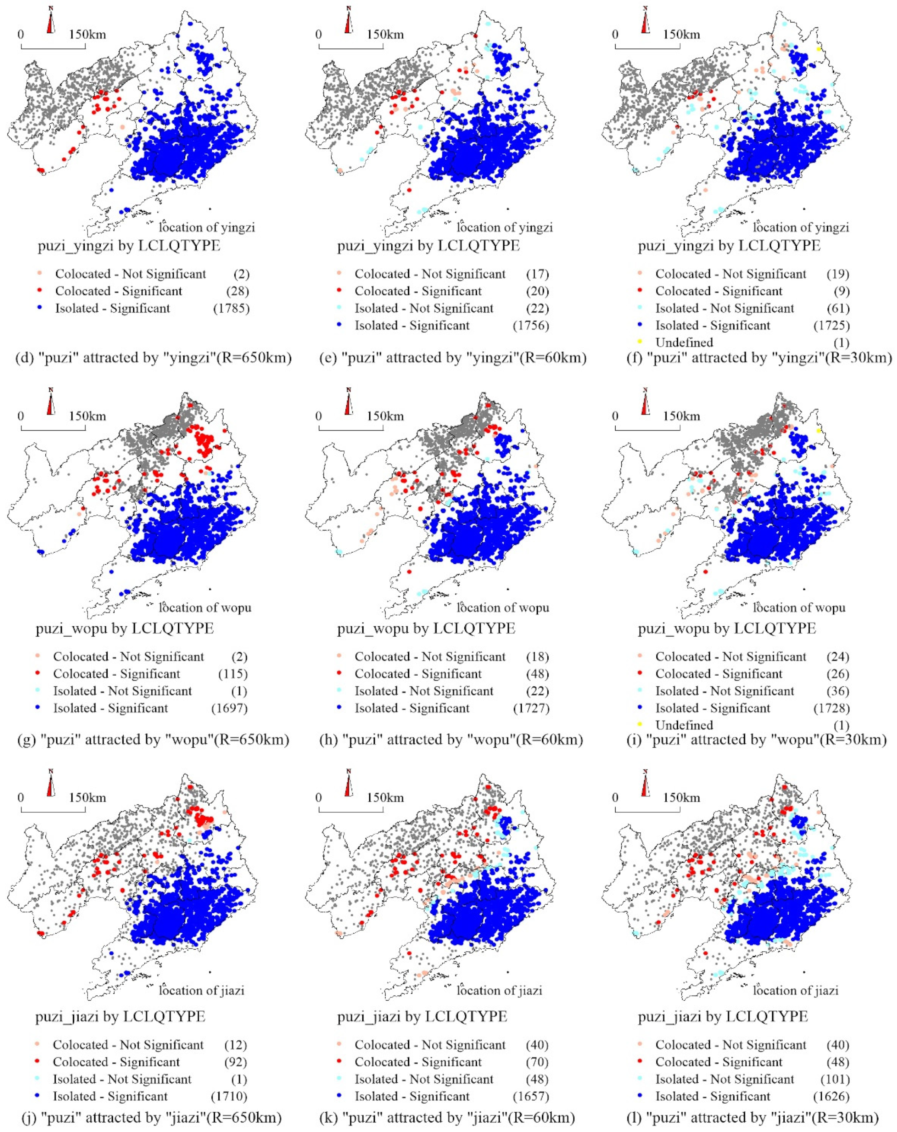
The detection results of the co-occurrence characteristics of toponyms between the Puzi and Zhangzi, Wopu, Yingzi, and Jiazi toponym groups under different bandwidths in the study area are illustrated in Figure 6. A bandwidth scale of 650 km was used to detect the co-occurrence characteristics of Puzi and other toponyms across the entire territory of Liaoning Province. Overall, co-occurrence between Puzi and the other toponym groups was very weak, and the mutual exclusion characteristics were significant. Similar characteristics were also observed at the scales of 60 km and 30 km. Regarding comprehensive scales, Puzi and Jiazi showed weak co-occurrence, with mutual exclusion in relation to Zhangzi being the most notable. This indicated that the toponym culture represented by Puzi was highly independent and lacked integration with the other toponym cultures.

4.1.2. Zhangzi with the Other Toponym Groups

The detection results of the co-occurrence characteristics of toponyms between Zhangzi and Puzi and Wopu, Yingzi, and Jiazi under different bandwidth restrictions are presented in Figure 7. On the scales of 650 km, 60 km, and 30 km, co-occurrence between Zhangzi and the other toponym groups was very weak, and the mutual exclusion characteristics were significant. In terms of comprehensive scales, Zhangzi and Yingzi revealed a certain degree of co-occurrence on each scale, and mutual exclusion in relation to Puzi was the most notable. This indicated that the toponym culture represented by Zhangzi also had strong independence and lacked integration with the other toponym cultures.

4.1.3. Wopu with the Other Toponym Groups

The detection results for the co-occurrence characteristics of toponyms between the Wopu and Puzi, Zhangzi, Yingzi, and Jiazi toponym groups under different bandwidths are illustrated in Figure 8. At a scale of 650 km, a certain co-occurrence between Wopu and the other toponym groups is evident; however, they tended to be mutually exclusive. On the 60 km and 30 km scales, co-occurrence between Wopu and the other toponym groups was also relatively weak, and the mutual exclusion characteristics were more significant. In terms of the various scales, Wopu and Jiazi showed clear co-occurrence. Although they also indicated a certain degree of co-occurrence with Puzi, Zhangzi, and Yingzi, their mutual exclusion characteristics were more notable. This suggested that the toponym culture represented by Wopu also had strong independence, with a certain exclusion from the other toponym cultures.

4.1.4. Yingzi with the Other Toponym Groups

The detection results of the co-occurrence characteristics of toponyms between the Yingzi and Puzi, Zhangzi, Wopu, and Jiazi toponym groups under different bandwidths are presented in Figure 9. At a scale of 650 km, although Yingzi had its own relatively isolated distribution area, it had clear co-occurrence with the other toponym groups. On the 60 km scale, compared with the global scale, co-occurrence between Yingzi and the other toponym groups was slightly weaker, and the mutual exclusion characteristics were more significant. On the 30 km scale, co-occurrence between Yingzi and the other toponym groups was also relatively weak, reflecting clear mutual exclusion characteristics. In terms of the various scales, Yingzi and Zhangzi revealed strong co-occurrence, especially in the western part of Liaoning. Although they also had a certain degree of co-occurrence with Puzi, Zhangzi, and Wopu, their mutual exclusion characteristics were more notable. This indicated that, although the toponym culture represented by Yingzi was relatively concentrated in the northwest of Liaoning, it had a certain degree of integration with the other toponyms.

4.1.5. Jiazi with the Other Toponym Groups

The detection results of the co-occurrence characteristics of toponyms between the Jiazi and Puzi, Zhangzi, Wopu, and Yingzi toponym groups under different bandwidths are illustrated in Figure 10. On the 650 km scale, a high degree of co-occurrence existed between Jiazi and the other toponym groups. On the 60 km scale, co-occurrence between Jiazi and the other toponym groups was slightly weaker; however, it also exhibited clear characteristics of mutual integration. On the 30 km scale, co-occurrence between Jiazi and the other toponym groups was also strong. In terms of the comprehensive scales, Jiazi and Puzi and Zhangzi, Wopu, and Yingzi demonstrated strong co-occurrence on each scale. These findings indicated that Jiazi belonged to a wide area of toponyms in geographical space, reflecting the common cultural characteristics of these toponyms and the strong integration of toponym culture.

4.2. Analysis of the TCOI Calculation Results and Co-Occurrence Characteristics

Based on the calculation results of the co-occurrence characteristics of the five toponym groups in Section 4.1, Formulas (6)–(9) were used to further calculate the T C O I A _ m B between any toponym group and the other four groups under the premise of determining a single fixed bandwidth. Figure 11 presents a comprehensive feature map of location co-occurrence between the five toponym groups. The number of toponyms with collocated-significant features in LCLQs in their respective toponym groups under specific bandwidths was then determined, i.e., T C O A A _ m B . Next, using Formula (10), the T C O I A _ k R _ m B of any toponym group and the other two toponym groups under the premise of three bandwidths was calculated. Finally, using Formula (11), the T C O I n A _ k R _ m B of the five interest toponym groups was calculated. The statistical calculation results of the co-occurrence index of the five high-frequency toponym groups (Puzi, Zhangzi, Wopu, Yingzi, and Jiazi) are provided in Table 2.
Puzi was the most frequent two-character toponym in the province. However, it had the lowest TCOI relative to the other four high-frequency toponyms, with a T C O I A _ k R _ m B index of only 4.17%, which was very weak among the five toponym groups, and the mutual exclusion feature was significant. Differentiating between different bandwidths, in the 30 km bandwidth at the county scale, the TCOI of the other four high-frequency toponyms was only 2.24% (Table 2), reflecting a high degree of exclusivity between this toponym and the others. As illustrated in Figure 11a–c, Puzi is concentrated in the mountainous areas of eastern Liaoning. Just as the source of toponyms resists foreign invasion, a natural need exists for a relatively isolated location selection. This results in a severe lack of cultural integration, making it a high-frequency village toponym that embodies the uniqueness of local culture.
Zhangzi was relatively numerous but concentrated in distribution mainly within the administrative region of Chaoyang City in the mountainous region of western Liaoning (Figure 11d,e). It showed a notable lack of integration with the other toponyms, with a T C O I A _ k R _ m B of only 6.62%. Just as the toponym Zhangzi mainly originated from the role of protection from beasts and thieves, it has distinct mountain characteristics and was strongly influenced by the terrain. Interestingly, unlike the other four toponym groups, its T C O I A _ m B increases as the bandwidth decreases (Table 2). This indicates that Zhangzi belongs to the narrow domain of toponyms, reflecting the cultural characteristics of local toponyms.
Wopu was highly concentrated in northern Liaoning (Figure 11g–i), situated along the plains and hills on both sides of the Liaohe River. Its co-occurrence characteristics with the other toponym groups were similar to those of Zhangzi but with a lower T C O I A _ k R _ m B of only 6.02% (Table 2). It exhibited extremely low co-occurrence with the other toponym groups across all the scales, classifying it as an isolated toponym group reflecting the unique regional cultural characteristics of these toponyms.
Although the Yingzi was concentrated in northwestern Liaoning, it exhibited a significant spatial overlap with Zhangzi (Figure 11j–l). This was reflected in a relatively high T C O I A _ k R _ m B of 34.00%, which indicated a relatively strong co-occurrence with the other toponym groups. The T C O I A _ m B at the provincial scale reached 51.57% (Table 2). Because Yingzi was primarily named after the military garrison in the late Qing Dynasty, it often occupied an important strategic position and provided convenient transportation. The significant overlap of Yingzi with Zhangzi and Wopu in northwestern Liaoning reflects the high degree of integration of these three high-frequency toponym cultures in the regional space.
The T C O I A _ k R _ m B between Jiazi and the other toponyms reached 53.35%, suggesting strong co-occurrence. At the provincial scale, the T C O I A _ m B reached 71.66%; at the prefecture-level city and regional cultural unit scales, it reached 48.61% and 32.25%, respectively, reflecting a relatively high degree of integration (Table 2). This is highly consistent with the connotation of the culture of the specific family blood relationship. The universality of Jiazi toponyms (Figure 11m–o) indicated that it was common in the province, reflecting a toponymic culture of common characteristics.
By integrating the co-occurrence measurement results of the five high-frequency toponym groups at the provincial, prefectural-level city, and regional cultural unit scales, the T C O I n A _ k R _ m B for the entire province of Liaoning was calculated as 28.63%. This finding reflected a certain degree of co-occurrence between toponym groups. For example, Yingzi and Jiazi have a higher TCOI, indicating that some province-wide cultural integration among the toponyms existed. However, the mutual exclusion characteristics were also relatively evident. This may be related to the ethnic policies of the historical period and the traditional Chinese social structure. Of course, the mutual exclusion characteristics of some toponym groups are also obvious. For example, Puzi and Zhangzi may have used the terrain as a mountain defense to gradually form a fortress culture in the mountainous areas, thus creating relatively isolated distribution characteristics of toponym groups. Wopu may have derived from the unique living culture and lifestyle of Chuangguandong Movement immigrants.

4.3. Recommended Reference Thresholds for the Evaluation of Toponym Co-Occurrence Features

Per the five groups of TCOI calculation schemes of toponym groups under different constraints outlined in the previous sections, the number of toponym groups, spatial distribution characteristics of toponym group co-occurrence, and quantitative statistical calculation results were comprehensively considered. Table 3 presents reference thresholds for the evaluation of toponym co-occurrence characteristics.

5. Discussion

5.1. Applicability and Expansibility of the TCOI

As shown in the results of Section 4, the five groups of two-character high-frequency toponym groups—Puzi, Zhangzi, Wopu, Yingzi, and Jiazi—have proven the rationality and effectiveness of the TCOI calculation framework. However, the proposal of a new method should undergo more diversified tests. Thus, the following two verification analyses were conducted to confirm the applicability and expansibility of the quantitative analysis and evaluation framework of TCOI and the application scenarios of thresholds.

5.1.1. A Larger Number of High-Frequency Single-Character Toponym Groups

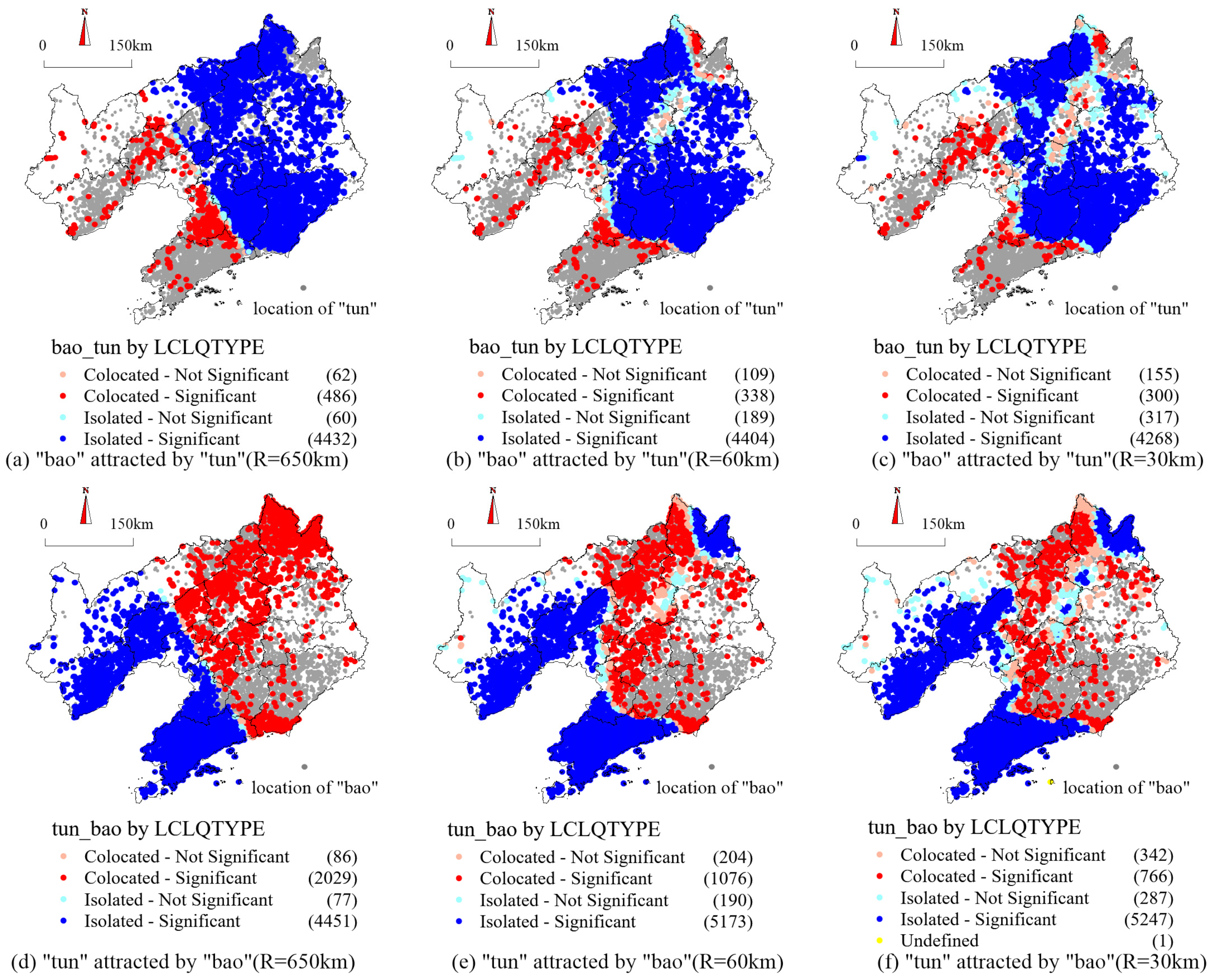
Based on the GIS basic database of village toponyms in Liaoning Province with 64,981 point objects, 5040 and 6643 toponym groups containing the words Bao and Tun in toponyms were retrieved, accounting for 7.76% and 10.22% of the total number of collected toponyms, respectively. It comprised numerous characteristic toponym groups. To compare the superiority of TCOI over the traditional kernel density method and SDE, the two traditional methods were used to analyse the toponym groups of Bao and Tun. With reference to the detection bandwidth of the regional cultural unit scale in Section 3.3, the KDE was set at a 30 km search radius with a grid of 1000 m. The maximum density of Bao and Tun was estimated to be 0.304/km2 (Figure 12a) and 0.333/km2 (Figure 12b), respectively. Figure 12c illustrates the co-occurrence relationship through the SDE. Using these toponym groups, the first aim is to verify the applicability of this research framework for single-character toponyms. The second aim is to verify the feasibility of calculating a TCOI for a larger number of toponym groups. The third aims is to verify the relative rationality of the recommended evaluation threshold. The fourth and final aim is to verify the advanced nature of the thematic map presentation method based on LCLQ analysis results.
Consistent with the parameters of the previous five trial toponym groups, the bandwidth scales used for verification were 650 km, 60 km, and 30 km. The spatial characteristics of the mutual co-occurrence of the Bao and Tun toponym groups were detected (Figure 13). Compared with the KDE and SDE (Figure 12), it is evident that the expression based on the LCLQ analysis results can reflect the multi-scale co-occurrence characteristics and co-occurrence quantity differences, as well as highlight the co-occurrence regional distribution and spatial heterogeneity characteristics.
In addition to improved spatial expression, the co-occurrence degree results with clear numerical expression can be obtained by calculating the co-occurrence index (Table 4). A comparison between Figure 13 and Table 4 indicates that the values of the co-occurrence indices T C O I A _ m B , T C O I A _ k R _ m B , and T C O I n A _ k R _ m B for the two single-character toponym groups, as well as the reference thresholds recommended in Table 2, are reasonable. The verification results indicate that the technical route, constructed co-occurrence index, and established evaluation thresholds are suitable for the detection of the co-occurrence relationship of single-character toponyms. In addition, they are suitable for the study of the spatial co-occurrence characteristics of a larger number of high-frequency toponyms.

5.1.2. A Smaller Number of Low-Frequency Toponym Groups

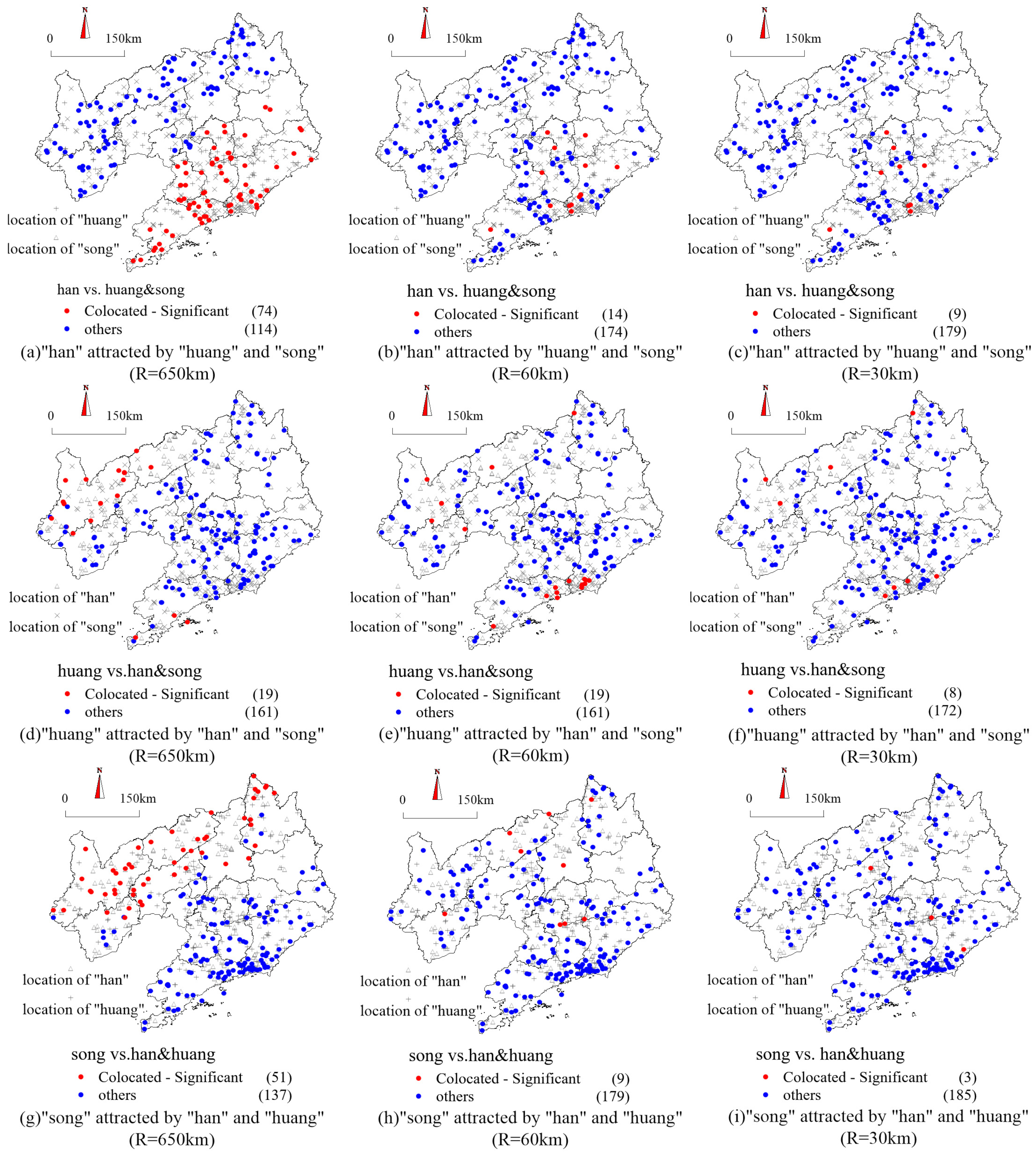
Considering the potential limitations of the five high-frequency two-character toponym groups used to construct TCOI, LCLQ trial calculations, and the recommended thresholds, we further extracted a small number of low-frequency toponym groups for verification research. Based on the actual situation in Liaoning Province, using the Liaoning Province village toponym GIS basic database with 64,981 point objects, we selected the toponyms Hanjia, Huangjia, and Songjia as toponym terms with clear semantic meanings. The search yielded 188, 180, and 188 toponyms containing the Hanjia, Huangjia, and Songjia toponym groups, respectively, accounting for 0.29%, 0.28%, and 0.29% of the total number of collected toponyms (Figure 14). The applicability of feature evaluation indicators and thresholds for evaluating low-frequency toponym groups was verified.
The detection parameters from the previous five toponym groups were used again, with bandwidth scales of 650 km, 60 km, and 30 km, to verify the mutual co-occurrence spatial characteristics between the toponym groups Hanjia, Huangjia, and Songjia. Under the three bandwidth settings, the LCLQ values between each pair of toponym groups were calculated. Then, using Formulas (6)–(9), the T C O I A _ m B between any given toponym group and the other two groups was further calculated under the condition of a single fixed bandwidth. This information was used to compile a comprehensive spatial co-occurrence feature map between the three toponym groups (Figure 15). Compared with the KDE map and SDE analysis map (Figure 14), the map of the smaller, low-frequency toponym groups provides a more intuitive representation, effectively revealing the co-occurrence quantity characteristics and co-occurrence spatial regions of toponyms at different research scales.
Similar to the calculation process for the five toponym groups in Section 4.2, the T C O I A _ k R _ m B and T C O I n A _ k R _ m B were calculated for any toponym group and the other two toponym groups under the three bandwidth conditions. The results presented in Figure 15 and Table 5 adequately reflect the actual characteristics of toponym co-occurrence. This fully validates that the constructed feature evaluation indicators and recommended thresholds are also applicable for evaluating the co-occurrence characteristics of low-frequency toponym groups.

5.2. Research Innovation and Contributions

5.2.1. Enrichment and Expansion of the Field of Toponym Econometric Research

In recent years, with the introduction of GIS technology, research on toponym econometrics has gained momentum in the field of toponymy. Research has focused on areas such as frequency analysis of toponym characters, kernel density analysis of high-frequency toponym characters, and thematic mapping of toponym distributions [5,37]. However, in addressing issues such as toponym co-occurrence, integration, and exclusion and promoting research directions such as toponym boundary identification, toponym cultural integration analysis, and toponym landscape creation, there is a lack of corresponding combined qualitative and quantitative research support. Using GIS technology as a foundation for exploring the co-occurrence relationships between high-frequency toponyms, this study enabled multi-solution verification of high-frequency multi-character and low-frequency single-character toponym groups, thereby expanding the scope of toponym econometric studies.

5.2.2. The Proposal of a Basic Framework for Spatial Co-Occurrence Research of Toponym Groups and a TCOI

This study proposed a basic framework for researching the phenomenon and characteristics of toponym co-occurrence and provided technical applications and parameter processing methods for each work phase. It engaged in innovative explorations in areas such as basic data collection, the application of important technical methods, the determination of appropriate research scales, and the construction of a TCOI. The technical framework and co-occurrence measurement indices designed in this study have important reference and demonstration value for researching the characteristics of toponym co-occurrence.

5.2.3. The First Application of the LCLQ Method in Toponym Co-Occurrence Research

This study employed the recently developed LCLQ method, which has clear geographical significance. This method possesses strong analytical capabilities for addressing typical issues such as regional coordination, spatial balance, and spatial conflicts, thereby enhancing the level of research on spatial interactions [50,54]. It was introduced to quantitatively analyse and measure the co-occurrence characteristics of high-frequency toponyms, and the applicability of the introduced technical method was verified. Several key technical aspects were explored, including the basic prerequisites for applying the technical method, parameter selection, software tools, and the presentation of conclusions, thereby enhancing the technical level of toponym econometric research.

5.2.4. Contribution to Empirical Research in Liaoning Province

This study validated the relevance of the fundamental framework, measurement indices, and technical methodologies employed in toponym co-occurrence research. Moreover, its findings on the spatial co-occurrence characteristics of five high-frequency two-character toponym groups, two high-frequency single-character toponym clusters, and three low-frequency two-character toponym clusters in Liaoning Province showed that the integration and exclusion characteristics of regional cultures can be effectively quantified. Furthermore, the study findings reveal spatial differentiation patterns in the regional cultural landscapes, provide a scientific basis for the identification of cultural typological zones and zoning, and can guide the coordinated development of local cultural preservation and tourism industries within Liaoning Province.

5.3. Limitations and Future Research Directions

The issues identified but not resolved in this study, as well as potential concerns that could be raised concerning the proposed framework and the TCOI, indicate the principal directions for future research.
First, the understanding and interpretation of the findings derived from the LCLQ method warrant further in-depth study. This method provides a practical new approach for analysing and measuring the co-occurrence of toponyms. Co-occurrence location relationships were asymmetric, meaning that the co-occurrence location quotient values calculated when comparing groups A and B differed from those calculated when comparing groups B and A . This study provides a persuasive explanation and examples of the reality of mutual co-occurrence among toponym groups; however, further research is required to confirm its findings.
Second, neighbourhood selection was performed using the LCLQ. Considering the nature of the co-occurrence of toponyms and the fact that the number of neighbouring toponyms did not exceed 1000, this study adopted a more geographically meaningful neighbourhood range based on spatial distance. However, the K-nearest neighbourhood option has not been verified, and its detection results remain to be verified in other studies.
Third, more work is needed concerning the aggregation and thresholds used in the TCOI. The LCLQ was found to be appropriate for analysing and comparing the spatial co-occurrence characteristics between two groups of toponyms. The single bandwidth TCOI ( T C O I A _ m B ), composite bandwidth TCOI ( T C O I A _ k R _ m B ), and global TCOI ( T C O I n A _ k R _ m B ) were verified to a certain extent in this study. Future research could be conducted to identify a more precise index integration method and more comprehensive determination of threshold boundaries.
Fourth, through applying the TCOI in future research, further exploration of quantitative analysis methods for toponym co-occurrence mechanisms could be undertaken. With regard to the spatial co-occurrence of toponyms, it is recommended that research be conducted to explore additional matters, such as the causes of co-occurrence and potential trajectories, which may require the development of better-targeted and more appropriate technical methods to promote the continuous expansion of research on toponym co-occurrence.

6. Conclusions

Toponyms are textual projections of human activity in space. They serve as a key means for interpreting the interactive relationship between regional environments and human activities and are an important tool for reconstructing spatial history and cultural context. In the fields of toponym cultural landscapes and toponym spatial analysis, employing scientific quantitative methods to measure the co-occurrence characteristics of toponyms makes it possible to transform toponyms from isolated symbols into computable spatial relationship variables. This provides a verifiable and deductive scientific paradigm for understanding the evolution of human–environment relationships. In this study, we designed a general framework for researching toponym co-occurrence and developed a comprehensive set of TCOI metrics tailored to different scales. In an experimental case study involving Liaoning Province, we employed the LCLQ method to analyse the spatial co-occurrence characteristics of five high-frequency two-character toponym groups. We determined that the T C O I A _ k R _ m B values for Puzi, Zhangzi, and Wopu were relatively low (less than 10%), while Yingzi and Jiazi had relatively high T C O I A _ k R _ m B values of 34.00% and 53.35%, respectively. The T C O I n A _ k R _ m B of 28.63% calculated for Liaoning Province may be related to factors such as ethnic policies, terrain, and traditional living habits during historical periods [39]. Based on the calculation results of the five toponym groups, evaluation thresholds for toponym co-occurrence characteristics were established. Finally, a larger group of high-frequency single-character toponyms and smaller group of low-frequency two-character toponyms were selected to validate the aforementioned methods and thresholds. The study reached clear and relatively reasonable conclusions, validating the applicability and extensibility of the designed research framework, constructed TCOI, and co-occurrence analysis techniques employed.
The study yielded clear and relatively reasonable conclusions, validating the applicability of the research framework and TCOI metrics. Its proposed framework and indices not only enhance the technical level of toponym co-occurrence research but can also be applied to other fields comprising natural and human elements, enriching spatial distribution theory and technical systems. In addition, cultural resource protection or rural revitalisation strategies can be formulated based on the results of TCOI research. For example, as a material carrier of the Chuangguandong Movement immigrant culture, Wopu has a low TCOI, indicating the uniqueness of its toponym cultural characteristics. Local cultural tourism departments can leverage this to explore the movement’s cultural traces, restore the authenticity of residential folk culture, and design activities such as “Chuangguandong lifestyle experiences” using “Wopu culture” as an intellectual property, thereby driving the development of rural tourism.

Author Contributions

Conceptualisation, G.W. and L.W.; methodology, F.H. and L.W.; software, F.H. and L.W.; validation, G.W. and F.H.; formal analysis, G.W. and F.H.; investigation, G.W. and F.H.; resources, G.W. and L.W.; data curation, G.W. and F.H.; writing—original draft preparation, G.W.and F.H.; writing—review & editing, F.H. and L.W.; visualisation, L.W. and F.H.; supervision, F.H.; project administration, G.W.; funding acquisition, G.W. All authors have read and agreed to the published version of the manuscript.

Funding

This research was funded by Project of Liaoning Provincial Department of Education, grant number LJ122410841003.

Data Availability Statement

Data are available upon request.

Acknowledgments

The authors would like to thank the editors and the reviewers for their contributions.

Conflicts of Interest

The authors declare no conflicts of interest.

Abbreviations

The following abbreviations are used in this manuscript:
SDEStandard deviation ellipse
KDEKernel density estimation
TCOIToponymic co-occurrence index
LCLQLocal co-location quotient
POIPoint of interest
CLQsCo-location quotients
GCLQsGlobal colocation quotients

References

  1. Perono Cacciafoco, F.; Cavallaro, F. Place Names: Approaches and Perspectives in Toponymy and Toponomastics; Cambridge University Press: Cambridge, MA, USA, 2023; pp. 1–23. [Google Scholar] [CrossRef]
  2. Jones, C.B.; Abdelmoty, A.I.; Finch, D.; Fu, G.; Vaid, S. The SPIRIT Spatial Search Engine: Architecture, Ontologies and Spatial Indexing; Springer: Berlin/Heidelberg, Germany, 2004; pp. 125–139. [Google Scholar] [CrossRef]
  3. Pinna, S. Cartographic erasure of landscape as a social concept: Changes in ancient rural practices and land-use policy behind the study of toponyms. A case study from Sardinia. Catena 2023, 229, 107229. [Google Scholar] [CrossRef]
  4. De Felice, P.; La Greca, F.; Siniscalchi, S. The place names of the Aragonese maps. Interpretative hypotheses, landscape readings and methodological proposals. Int. J. Cartogr. 2022, 8, 3–17. [Google Scholar] [CrossRef]
  5. Jiao, M.; Lu, L. Spatiotemporal distribution of toponymic cultural heritage in Jiangsu Province and its historical and geographical influencing factors. Herit. Sci. 2024, 12, 377. [Google Scholar] [CrossRef]
  6. Lu, Q.; Sun, P.; Wang, S.; Xiang, H.; Wang, S. Spatial distribuion and genesis of the cutural landscape of vilage names inthe Chongqing section of the Three Gorges Reservoir area in China. Mt. Res. 2024, 42, 108–122. [Google Scholar] [CrossRef]
  7. Zhi, L.; Li, R.; Fu, X.; Guo, F. Data mining method of hot-toponym and its co-occurrence in crowdsourcing text written by tourists. Sci. Surv. Mapp. 2016, 41, 144–151. [Google Scholar] [CrossRef]
  8. Amandanu, R.; Arijuddin, B.I.; Jauhari, A.; Ariseno, I.A. Toponymy analysis as geosocial cultural approach on disaster mitigation studies in Sumberagung Village Pracimantoro District Wonogiri Regency. IOP Conf. Ser. Earth Environ. Sci. 2024, 1314, 12122. [Google Scholar] [CrossRef]
  9. Wang, R.; Liu, Y.; Xu, Y. The construction of theoretical system of touristic toponymy. J. Arid Land Resour. Environ. 2021, 35, 167–174. [Google Scholar] [CrossRef]
  10. Jett, S.C. Place-naming, environment, and perception among the Canyon de Chelly Navajo of Arizona. Prof. Geogr. 1997, 49, 481–493. [Google Scholar] [CrossRef]
  11. Fagúndez, J.; Izco, J. Diversity patterns of plant place names reveal connections with environmental and social factors. Appl. Geogr. 2016, 74, 23–29. [Google Scholar] [CrossRef]
  12. Membrado-Tena, J.C. Interpreting protohistoric societies through place names of landscape features: A case study in València, Spain. Landsc. Res. 2021, 46, 811–827. [Google Scholar] [CrossRef]
  13. Cao, Y.; Xing, H.; Cui, B. Knowledge graph construction of toponymic evolution. Sci. Surv. Mapp. 2025, 50, 127–142. [Google Scholar] [CrossRef]
  14. Sharma, P.; Samal, A.; Soh, L.; Joshi, D. A spatially-aware algorithm for location extraction from structured documents. Geoinformatica 2023, 27, 645–679. [Google Scholar] [CrossRef]
  15. Zhao, S.; Hu, X.; Tang, J.; Zheng, X.; Jin, X.; Wei, B. Characteristics of cultural landscape genome maps and groups: A study on names of ancient towns in Hunan Yuanshui Basin. Geogr. Res. 2023, 42, 3020–3042. [Google Scholar] [CrossRef]
  16. Sun, B.; Guo, C.; Yang, Y.; Ge, W. Spatial distribution characteristics of rural place-name cultural landscape based on GIS approach in Chengde. Sci. Geogr. Sin. 2017, 37, 244–251. [Google Scholar] [CrossRef]
  17. Li, J.; Xiao, Y.; Yan, J.; Liang, C.; Zhong, H. Spatiotemporal evolution characteristics and causative analysis of toponymic cultural landscapes in traditional villages in northern Guangdong, China. Sustainability 2025, 17, 271. [Google Scholar] [CrossRef]
  18. Xia, Z.; Jin, S.; Liu, Y. Analysis on spatial distribution and regional characteristics of place names inthe China-North Korea border: Take the place names of Yanbian and Hamgyöngbuk-do as an example. World Reg. Stud. 2023, 32, 50–62. [Google Scholar] [CrossRef]
  19. Zeini, N.T.; Abdel-Hamid, A.M.; Soliman, A.S.; Okasha, A.E. An exploratory study of place-names in Sinai Peninsula, Egypt: A spatial approach. Ann. GIS 2018, 24, 177–194. [Google Scholar] [CrossRef]
  20. Kotowski, M.; Nowak, A. Tracing vegetation changes through the testimony of early settlers: A spatio-temporal analysis of plant-based place names as ecological evidence. Glob. Ecol. Conserv. 2025, 59, e3552. [Google Scholar] [CrossRef]
  21. Wang, T.; Wu, Y.; Li, C.; Li, J.; Chen, C.; Ge, X.; Liu, Y. Construction of genetic information chain and bionic model of geo-graphical names and cultural landscapes: An example of geographical names of the South China Sea Islands. World Reg. Stud. 2023, 32, 28–40. [Google Scholar] [CrossRef]
  22. Wang, W.; Shi, Q.; Wang, G. Analysis of performance and genetic characteristics of cultural landscapes in traditional villages along the Jinzhong Section of the Wanli Tea Road from a landscape gene information chain perspective: A case study of Xiamen village. Sustainability 2024, 16, 8131. [Google Scholar] [CrossRef]
  23. Ma, R.; Chen, J. The spatial pattern and influencing factors of the cultural landscape of generic place names in the Yangtze River Delta. Geogr. Res. 2022, 41, 764–776. [Google Scholar] [CrossRef]
  24. Zhang, H. Geo-Informatic Graph Based Generation Method for Place-Name Culture—A Case Study of Village Name in China. Ph.D. Thesis, Nanjing Normal University, Nanjing, China, 2020. [Google Scholar]
  25. Wang, F.; Wang, G.; Hartmann, J.; Luo, W. Sinification of Zhuang place names in Guangxi, China: A GIS-based spatial analysis approach. Trans. Inst. Br. Geogr. 2012, 37, 317–333. [Google Scholar] [CrossRef]
  26. Liu, F.; Meng, K. Analysis of geomorphic environment elements and landscape features of cultural administrative place names. Arab. J. Geosci. 2021, 14, 1684. [Google Scholar] [CrossRef]
  27. Dong, X. The Study of Human Geographic Features and Spatial Distribution in Chinese Toponymy. Master’s Thesis, Shanxi Normal University, Taiyuan, China, 2012. [Google Scholar]
  28. Garcia-Quera, N. The etymology of opaque place names based on a cognitive and interdisciplinary method. Lang. Sci. 2025, 107, 101688. [Google Scholar] [CrossRef]
  29. Ursini, F.; Zhang, Y.S. Place and place names: A unified model. Front. Psychol. 2023, 14, 1237422. [Google Scholar] [CrossRef]
  30. Cavallaro, F.; Perono Cacciafoco, F.; Tan, Z.X. Sequent occupance and toponymy in Singapore: The diachronic and synchronic development of urban place names. Urban Sci. 2019, 3, 98. [Google Scholar] [CrossRef]
  31. Basik, S. Problematizing urban microtoponyms. Geogr. Compass 2024, 18, e12732. [Google Scholar] [CrossRef]
  32. Wu, J.; Feng, Z.; Zhang, X.; Xu, Y.; Peng, J. Delineating urban hinterland boundaries in the Pearl River Delta: An approach integrating toponym co-occurrence with field strength model. Cities 2020, 96, 102457. [Google Scholar] [CrossRef]
  33. Mitxelena-Hoyos, O.; Amaro-Mellado, J. A Comparison of Cartographic and Toponymic Databases in a Multilingual Environment: A Methodology for Detecting Redundancies Using ETL and GIS Tools. ISPRS Int. J. Geoinf. 2023, 12, 70. [Google Scholar] [CrossRef]
  34. Isoda, Y.; Muranaka, A.; Tanibata, G.; Hanaoka, K.; Ohmura, J.; Tsukamoto, A. Strengths of exaggerated tsunami-originated placenames: Disaster subculture in Sanriku Coast, Japan. ISPRS Int. J. Geoinf. 2019, 8, 429. [Google Scholar] [CrossRef]
  35. Wang, Y.; Ge, D.; Zhang, T.; Wang, Y. The sustainable development of choronymic cultural landscapes in China based on geo-informatic tupu. Sustainability 2019, 11, 4302. [Google Scholar] [CrossRef]
  36. Bréelle, D. French names bestowed by the Baudin expedition along the coasts of Australia: A snapshot of French national spirit during Napoleonic times. J. Hist. Geogr. 2024, 86, 47–66. [Google Scholar] [CrossRef]
  37. Wang, F.; Zhang, L.; Zhang, G.; Zhang, H. Mapping and spatial analysis of multiethnic toponyms in Yunnan, China. Cartogr. Geogr. Inf. Sci. 2014, 41, 86–99. [Google Scholar] [CrossRef]
  38. Cui, L.; Jiao, X. Dalian place name culture research. Sinogram Cult. 2025, 37, 4–6. [Google Scholar] [CrossRef]
  39. Feng, S.; Yang, C.; Cao, F.; Zhang, Q. Spatial distribution characteristics and causes of cultural landscape of rural place names in multi-ethnic integration zone-Taking Chaoyang City, Liaoning Province as an example. J. Northwest Norm. Univ. (Nat. Sci. Ed.) 2019, 55, 129–134. [Google Scholar] [CrossRef]
  40. Gai, Y. Sociolinguistic Study of Panjin Place Names. Master’s Thesis, Liaoning Normal University, Dalian, China, 2018. [Google Scholar]
  41. Wu, C. The review and prospect of the research on the geographical names in Liaoning Province. J. Hulunbuir Univ. 2023, 31, 80–84. [Google Scholar]
  42. Xi, X.; Bi, Y. Analysis of the types and main characteristics of island place names in Liaoning. Mar. Inf. 2016, 31, 39–42. [Google Scholar]
  43. Zhao, X. Liaoning High-Frequency Place Names. Available online: http://epaper.lnd.com.cn/lnrbepaper/pc/layout/202111/17/node_15.html (accessed on 10 June 2024).
  44. Wang, Y. The characteristics of the local pulse of the cultural landscape of the street toponymic names in Dalian city. Territ. Nat. Resour. Stud. 2019, 41, 66–69. [Google Scholar] [CrossRef]
  45. Chen, B. Rename in county-to-city upgrading in China since the reform and opening-up. Geogr. Res. 2019, 38, 1222–1235. [Google Scholar]
  46. Zhao, F.; Fu, Y.; Luan, G.; Zhang, S.; Cai, J.; Ding, J.; Qian, J.; Xie, Z. Spatial-temporal characteristic analysis of ethnic toponyms based on spatial information entropy at the rural level in northeast China. Entropy 2020, 22, 393. [Google Scholar] [CrossRef]
  47. Leslie, T.F.; Kronenfeld, B.J. The colocation quotient: A new measure of spatial association between categorical subsets of points. Geogr. Anal. 2011, 43, 306–326. [Google Scholar] [CrossRef]
  48. Cromley, R.G.; Hanink, D.M.; And Bentley, G.C. Geographically weighted colocation quotients: Specification and application. Prof. Geogr. 2014, 66, 138–148. [Google Scholar] [CrossRef]
  49. Wang, F.; Hu, Y.; Wang, S.; And Li, X. Local indicator of colocation quotient with a statistical significance test: Examining spatial association of crime and facilities. Prof. Geogr. 2017, 69, 22–31. [Google Scholar] [CrossRef]
  50. Liu, H.; Kwan, M.; Hu, M.; Wang, H.; Zheng, J. Application of the local colocation quotient method in jobs-housing balance measurement based on mobile phone data: A case study of Nanjing City. Comput. Environ. Urban Syst. 2024, 109, 102079. [Google Scholar] [CrossRef]
  51. Meng, B.; Gao, L.; Li, R. Spatial correlation analysis of residential and employment elements in Beijing based on collaborative location quotient. Acta Geogr. Sin. 2021, 76, 1380–1393. [Google Scholar] [CrossRef]
  52. Li, L.; Cheng, J.; Bannister, J.; And Mai, X. Geographically and temporally weighted co-location quotient: An analysis of spatiotemporal crime patterns in greater Manchester. Int. J. Geogr. Inf. Sci. 2022, 36, 918–942. [Google Scholar] [CrossRef]
  53. Pan, X.; Jin, C.; Zhang, S.; Chen, Y. Spatial correlation and influencing factors of the food retail industry site selection: Take cafes and tea houses in Shanghai as an example. Econ. Geogr. 2023, 43, 231–239. [Google Scholar] [CrossRef]
  54. Pei, Z.; Li, J.; Guo, J.; Li, Q.; Chen, J. Using local co-location quotient and niche-based model to assess fire risk in urban environments: A case study of Beijing, China. Sustain. Cities Soc. 2023, 99, 104989. [Google Scholar] [CrossRef]
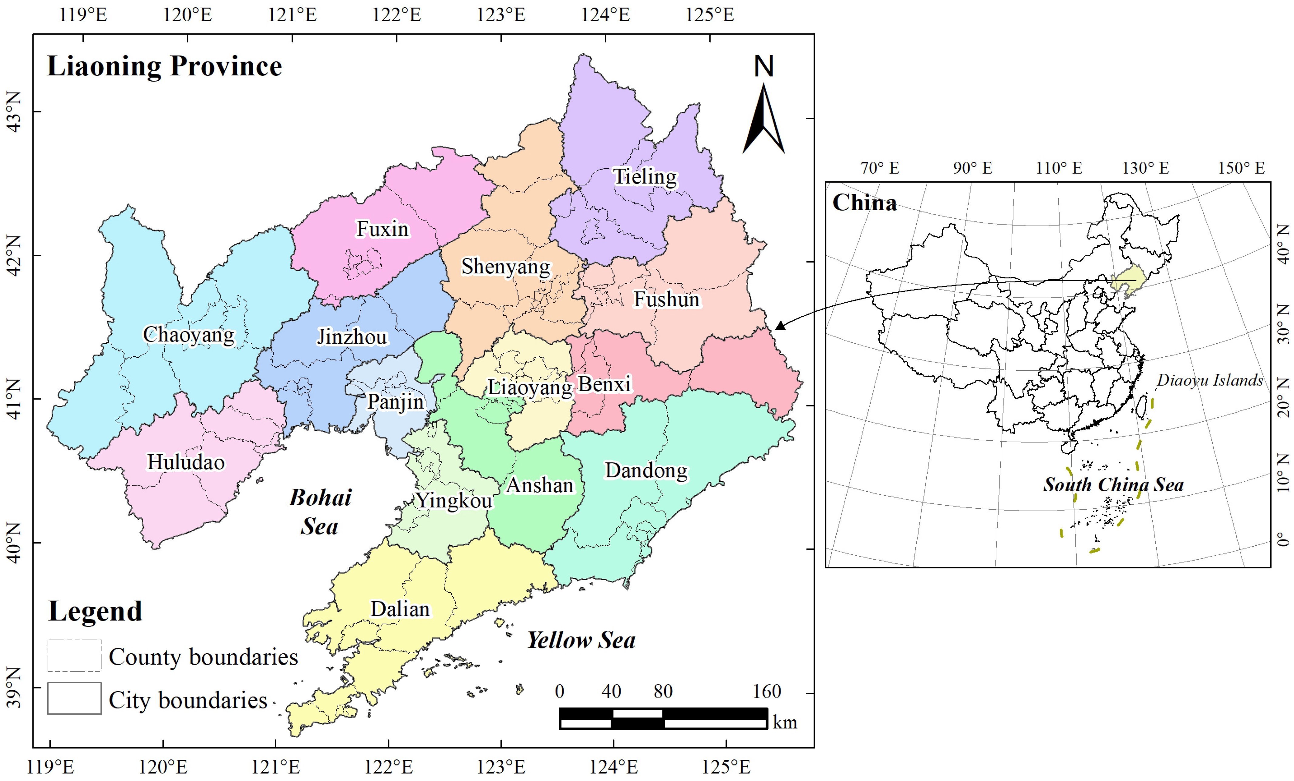
Figure 1. Geographical location of the research area.
Ijgi 14 00343 g001
Figure 2. Distribution of village name points. Black fonts represent regional cultural units, and red fonts represent prefecture-level cities.
Ijgi 14 00343 g002
Figure 3. Spatial distribution of the five two-character high-frequency village toponym groups.
Ijgi 14 00343 g003
Figure 4. Research framework for the measurement of toponym co-occurrence characteristics.
Ijgi 14 00343 g004
Figure 5. Measurement of the toponymic co-occurrence characteristics using the local co-location quotient (LCLQ).
Ijgi 14 00343 g005
Figure 6. Characteristics of toponym co-occurrence between Puzi with the other toponym groups under different bandwidths.
Ijgi 14 00343 g006aIjgi 14 00343 g006b
Figure 7. Characteristics of toponym co-occurrence between Zhangzi with the other toponym groups under different bandwidths.
Ijgi 14 00343 g007
Figure 8. Characteristics of toponym co-occurrence between Wopu with the other toponym groups under different bandwidths.
Ijgi 14 00343 g008aIjgi 14 00343 g008b
Figure 9. Characteristics of toponym co-occurrence between Yingzi with the other toponym groups under different bandwidths.
Ijgi 14 00343 g009
Figure 10. Characteristics of toponym co-occurrence between Jiazi with the other toponym groups under different bandwidths.
Ijgi 14 00343 g010aIjgi 14 00343 g010b
Figure 11. Characteristics of toponym co-occurrence between five toponym groups under different bandwidths.
Ijgi 14 00343 g011aIjgi 14 00343 g011b
Figure 12. Verification of the kernel density distribution of the two selected high-frequency single-character toponym groups and the expression of conventional co-occurrence characteristics: Kernel density estimation (KDE) and corresponding standard deviation ellipse (SDE) for village names in Bao (a) and Tun (b), and the co-occurrence relationship between Bao and Tun reflected by the SDE (c).
Ijgi 14 00343 g012
Figure 13. LCLQ detection results and co-occurrence characteristics of two high-frequency single-character toponym groups.
Ijgi 14 00343 g013
Figure 14. Verification of the kernel density distribution of the three selected low-frequency toponym groups and the expression of conventional co-occurrence characteristics: Kernel density estimation (KDE) and corresponding standard deviation ellipse (SDE) for village names in Hanjia (a), Huangjia (b), and Songjia (c), and the co-occurrence relationship between the three toponym groups reflected by the SDE (d).
Ijgi 14 00343 g014
Figure 15. Characteristics of toponym co-occurrence between three low-frequency toponym groups under different bandwidths.
Ijgi 14 00343 g015
Table 1. Output parameter table developed using the ArcGIS Pro 3.3 co-location analysis tool.
TypesCo-Location TypeLCLQ BinStatistical Characteristics
Description
The Co-Occurrence Characteristics of Toponyms
01Co-located—Significant0In a certain neighbourhood or bandwidth range, L C L Q > 1, and statistical significance p value < 0.05.Within the determined neighbourhood or bandwidth range, the relevant group A toponyms and group B toponyms showed statistically significant spatial co-occurrence characteristics, reflecting clear mutual toponymic culture integration.
02Co-located—Not Significant1In a certain neighbourhood or bandwidth range, L C L Q > 1, and statistical significance p value > 0.05.Within the determined neighbourhood or bandwidth range, the relevant group A toponyms and group B toponyms showed statistically insignificant spatial co-occurrence characteristics, reflecting clear mutual toponymic culture integration.
03Isolated—Significant2In a certain neighbourhood or bandwidth range, L C L Q ≤ 1, and the statistical significance p value < 0.05.Within the determined neighbourhood or bandwidth range, the relevant group A toponyms and group B toponyms showed statistically significant spatial exclusion characteristics, reflecting clear mutual toponymic culture exclusivity.
04Isolated—Not Significant3In a certain neighbourhood or bandwidth range, L C L Q ≤ 1, and statistical significance p value > 0.05.Within the determined neighbourhood or bandwidth range, the relevant group A toponyms and group B toponyms showed statistically insignificant spatial exclusion characteristics, reflecting clear mutual toponymic culture exclusivity.
05Undefined4 A i does not have any group B toponyms within a defined neighbourhood or bandwidth.In such cases, there was no spatial correlation between group A and group B toponyms in the determined neighbourhood or bandwidth range.
Note: LCLQ, local co-location quotient.
Table 2. Toponym co-occurrence index (TCOI) statistics for the five high-frequency village toponym groups in Liaoning Province.
Village Toponym GroupsBandwidths/km
R 1 = 650 R 2 = 60 R 3 = 30
Puzi S U M A 181518151815
S U M T C O A A _ m B = 0 1277551
T C O I A _ M B 7.00%4.13%2.81%
S U M A i _ B m _ L C L Q   B i n = 0 26314683
λ 0.8480.8350.799
T C O I A _ m B 5.94%3.45%2.24%
T C O I A _ k R _ m B 4.17%
Zhangzi S U M A 129512951295
S U M T C O A A _ m B = 0 95134114
T C O I A _ M B 7.34%10.35%8.80%
S U M A i _ B m _ L C L Q   B i n = 0 126160133
λ 0.7590.7390.735
T C O I A _ m B 5.57%7.65%6.47%
T C O I A _ k R _ m B 6.62%
Wopu S U M A 117311731173
S U M T C O A A _ m B = 0 1137065
T C O I A _ M B 9.63%5.97%5.54%
S U M A i _ B m _ L C L Q   B i n = 0 212138111
λ 0.8280.8380.808
T C O I A _ m B 7.97%5.00%4.48%
T C O I A _ k R _ m B 6.02%
Yingzi S U M A 106610661066
S U M T C O A A _ m B = 0 726319254
T C O I A _ M B 68.11%29.92%23.83%
S U M A i _ B m _ L C L Q   B i n = 0 955397301
λ 0.7570.7470.738
T C O I A _ m B 51.57%22.35%17.58%
T C O I A _ k R _ m B 34.00%
Jiazi S U M A 106010601060
S U M T C O A A _ m B = 0 1002704466
T C O I A _ M B 94.53%66.42%43.96%
S U M A i _ B m _ L C L Q   B i n = 0 1324808540
λ 0.7580.7320.734
T C O I A _ m B 71.66%48.61%32.25%
T C O I A _ k R _ m B 53.35%
Table 3. Threshold definitions derived from the toponymic co-occurrence index (TCOI) and evaluation of co-occurrence characteristics.
TCOIThreshold Range and Co-Occurrence Characteristics Evaluation
T C O I 55 % There is strong co-occurrence between toponym groups.
40 % T C O I < 55 % There is relatively strong co-occurrence between toponym groups.
25 % T C O I < 40 % There is a certain degree of co-occurrence between toponym groups.
10 % T C O I < 25 % There is weak co-occurrence between toponym groups, showing certain characteristics of mutual exclusion.
T C O I < 10 % There is very weak co-occurrence between toponym groups, with significant characteristics of mutual exclusion.
Table 4. Statistics on the co-occurrence index of the two high-frequency single-character toponym groups selected for verification.
Village Toponym GroupsBandwidths/km
R1 = 650R2 = 60R3 = 30
Bao T C O A A _ m B 486338300
S U M A 504050405040
T C O I A _ m B 9.64%6.71%5.95%
T C O I A _ k R _ m B 7.60%
Tun T C O A A _ m B 20291076766
S U M A 664366436643
T C O I A _ m B 30.54%16.20%11.53%
T C O I A _ k R _ m B 21.04%
T C O I n A _ k R _ m B = 15.82%
Table 5. Statistics on the co-occurrence index of the three low-frequency toponym groups selected for verification.
Village Toponym GroupsBandwidths/km
R1 = 650R2 = 60R3 = 30
Hanjia S U M A 188188188
S U M T C O A A _ m B = 0 74149
T C O I A _ M B 39.36%7.45%4.79%
S U M A i _ B m _ L C L Q   B i n = 0 1261610
λ 0.9230.7560.745
T C O I A _ m B 36.32%5.63%3.57%
T C O I A _ k R _ m B 21.32%
Huangjia S U M A 180180180
S U M T C O A A _ m B = 0 19198
T C O I A _ M B 10.56%10.56%4.44%
S U M A i _ B m _ L C L Q   B i n = 0 19219
λ 0.7070.7430.750
T C O I A _ m B 7.46%7.85%3.33%
T C O I A _ k R _ m B 6.54%
Songjia S U M A 188188188
S U M T C O A A _ m B = 0 5193
T C O I A _ M B 27.13%4.79%1.60%
S U M A i _ B m _ L C L Q   B i n = 0 5994
λ 0.7610.7070.816
T C O I A _ m B 20.63%3.39%1.30%
T C O I A _ k R _ m B 12.09%
T C O I n A _ k R _ m B = 14.65%
Disclaimer/Publisher’s Note: The statements, opinions and data contained in all publications are solely those of the individual author(s) and contributor(s) and not of MDPI and/or the editor(s). MDPI and/or the editor(s) disclaim responsibility for any injury to people or property resulting from any ideas, methods, instructions or products referred to in the content.