An Approach to Selecting an E-Commerce Warehouse Location Based on Suitability Maps: The Case of Samara Region
Abstract
1. Introduction
2. Related Works
- Natural Area Characteristics:
- Transportation Accessibility:
- Legal and Policy Constraints:This includes regulatory restrictions and the alignment of the warehouse location with national or regional policy goals [41,42]. For example, activities unrelated to the conservation of natural ecosystems are prohibited on lands designated as state natural reserves [43]. It is also forbidden to change the intended use of land or repurpose it for incompatible objectives. On federally protected lands, the construction of industrial, commercial, or residential facilities is generally banned unless directly tied to the protected area’s functioning. Water protection areas, whose width is defined by the Water Code, also impose strict construction restrictions [44,45]. These areas must be excluded from warehouse site consideration. Moreover, from a policy perspective, warehouse sites should be situated as far as possible from such protected areas. Consequently, attributes in this category include distance to heritage sites [46], reserves, sanctuaries, and national parks [47,48].
- Economic Viability Factors:These include the distance from the proposed warehouse site to key pick-up points and local population size [31,49]. Proximity to pick-up points reduces transportation costs, while population size serves as a proxy for both potential customer base and local labor availability, which are important factors when selecting a warehouse location [50].
- Knowledge of Specific Alternatives:This involves the identification of particular candidate areas for warehouse construction. Such knowledge can be directly elicited from DMs when the number of alternatives is small. For instance, Cetinkaya et al. considered three alternative areas for locating an emergency warehouse [51]. However, in scenarios with a large spatial area and numerous alternatives, it becomes difficult for DMs to evaluate each option. In such cases, decision makers are presented with a limited number of attribute-based alternative profiles, usually no more than seven, given the limitations of human working memory [52,53], and are asked to express preference relations among them.
- Knowledge of Attribute Aggregation:This refers to how individual land attributes are combined to assess overall suitability for a specific purpose. Such knowledge is formalized through the construction of criteria and an aggregation operator. The criteria construction process transforms each attribute into a normalized scale, typically within the [0, 1] interval, making it compatible with standard aggregation techniques [54].
- , if ;
- and
3. Materials and Methodology
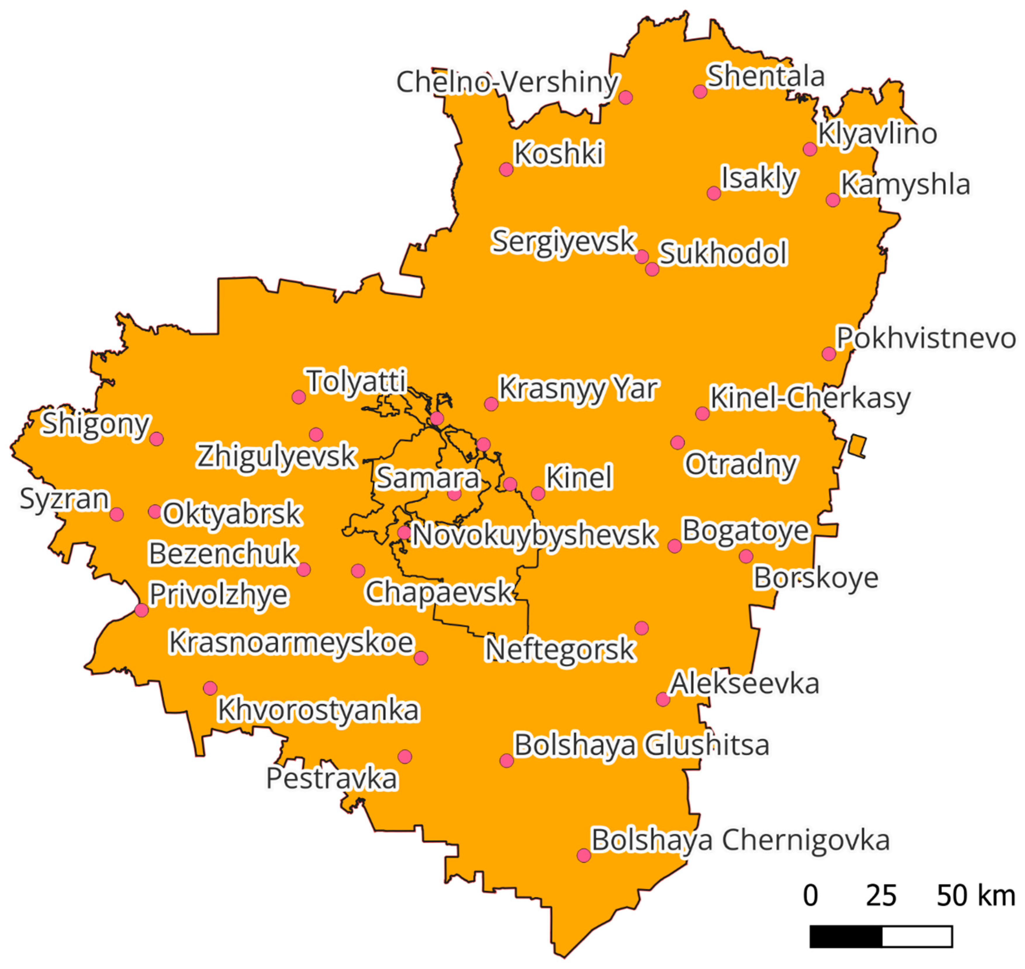
3.1. Field of Study
3.2. Warehouse Site Attributes and Corresponding GIS Layers
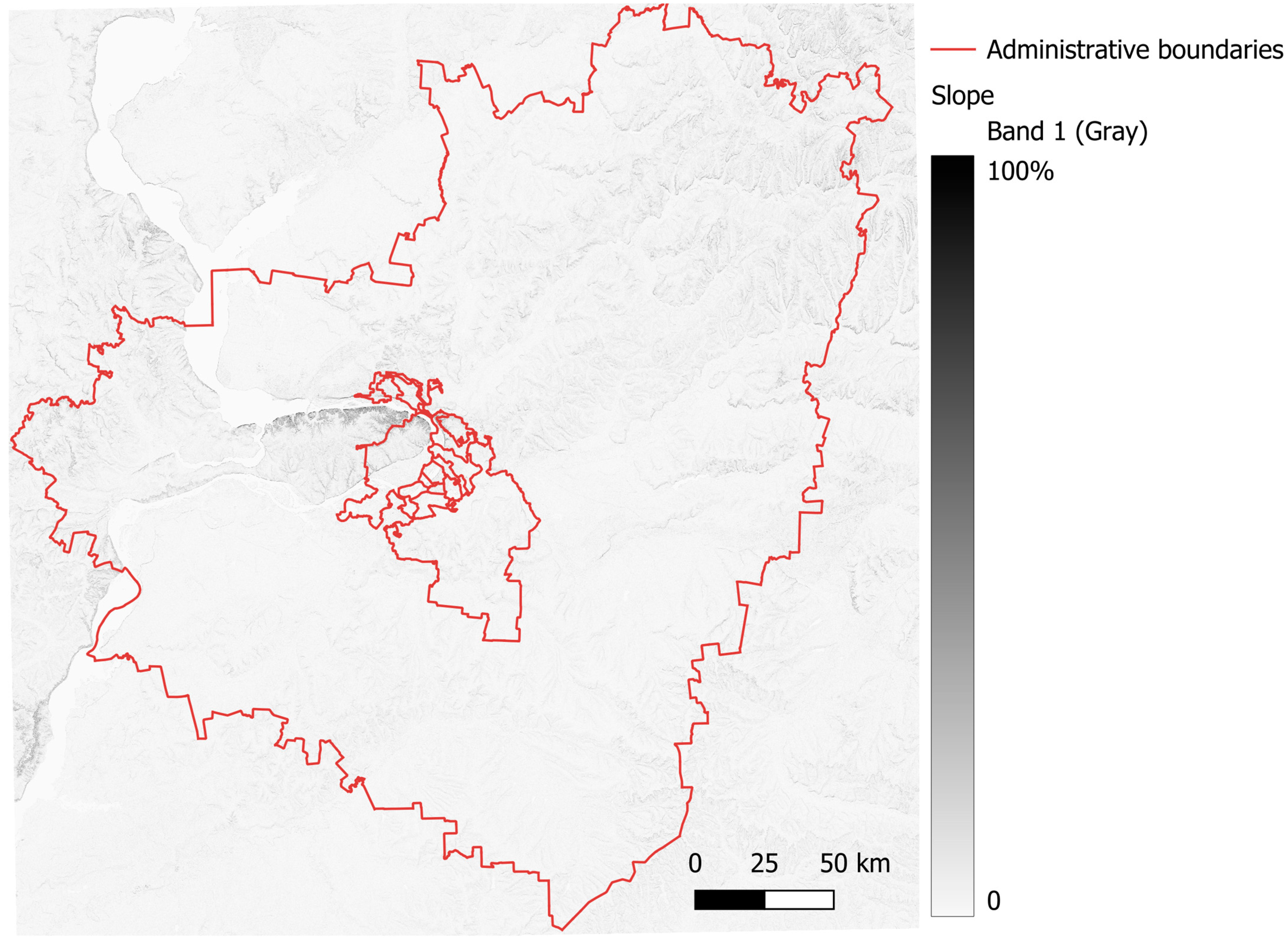
3.2.1. Quantitative Attribute a1 “Terrain Slope”
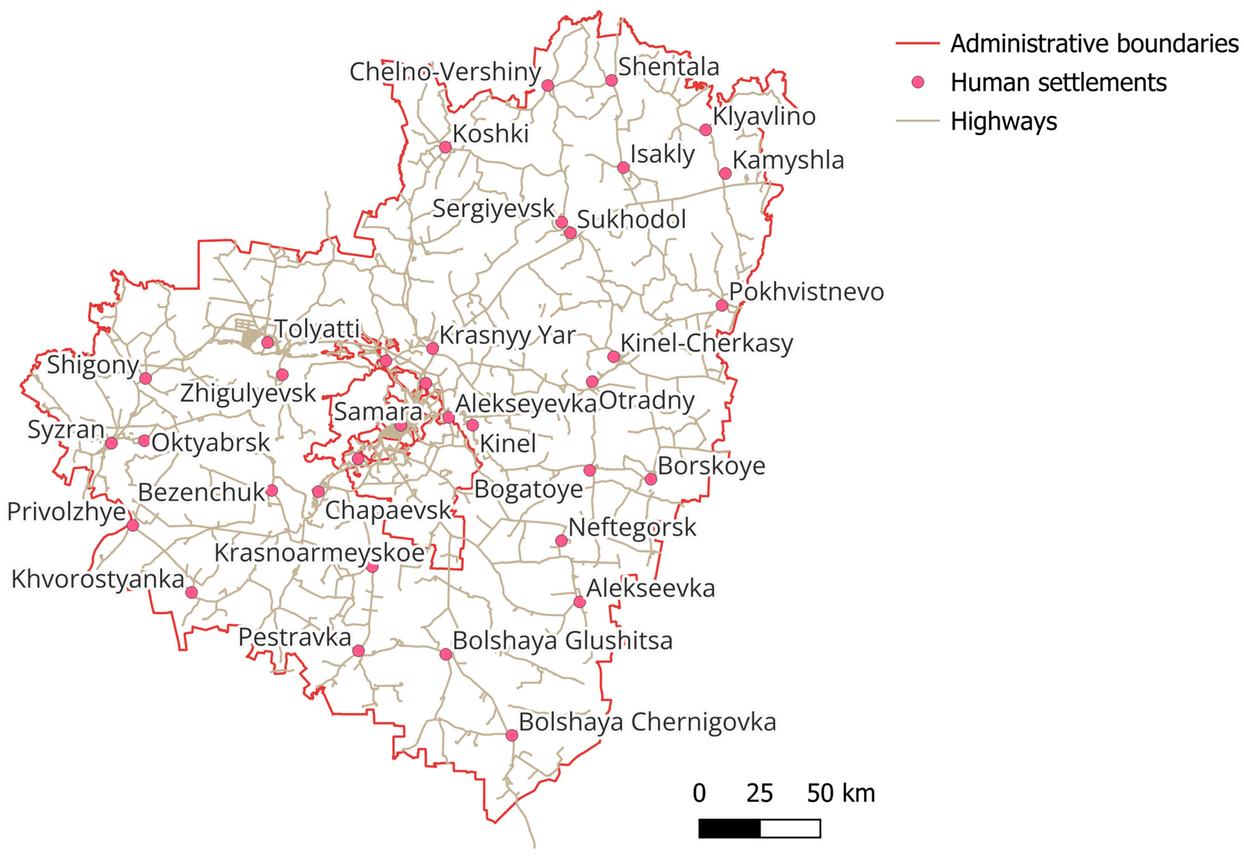
3.2.2. Quantitative Attribute a2 “Distance to Highways”
3.2.3. Quantitative Attribute a3 “Average Travel Time”
3.2.4. Quantitative Attribute a4 “Distance to Protected Areas”
3.2.5. Quantitative Attribute a5 “Average Distance to Pick-Up Points”
3.2.6. Binary Attributes Corresponding to the Constraints Imposed on the Site
3.3. Site Suitability Criteria
- As a suitability assessment—an undefined quantitative indicator representing how well stakeholder requirements are satisfied;
- As a logical evaluation of the degree of truth of the statement that the slope fully meets all requirements;
- As the degree of membership of the slope value in a fuzzy set representing ideal slope conditions;
- As the percentage of satisfied requirements.
- the World Database on Protected Areas, which contains data on national parks, nature reserves, and other types of protected natural areas;
- the National Platform for Common Geospatial Information Services of China, also known as Tianditu, which serves a similar function to the Russian Public Cadastral Map;
- the European Union Digital Elevation Model, which provides digital terrain elevation data for the EU territory.
3.4. Construction of the Criteria Aggregation Operator
4. Implementation
- The values for the criterion “Terrain slope” were derived from the elevation map (SRTM 30 data, loaded via the OpenTopographyDEM plugin) using the Raster Calculator (Raster → Analysis → Slope).
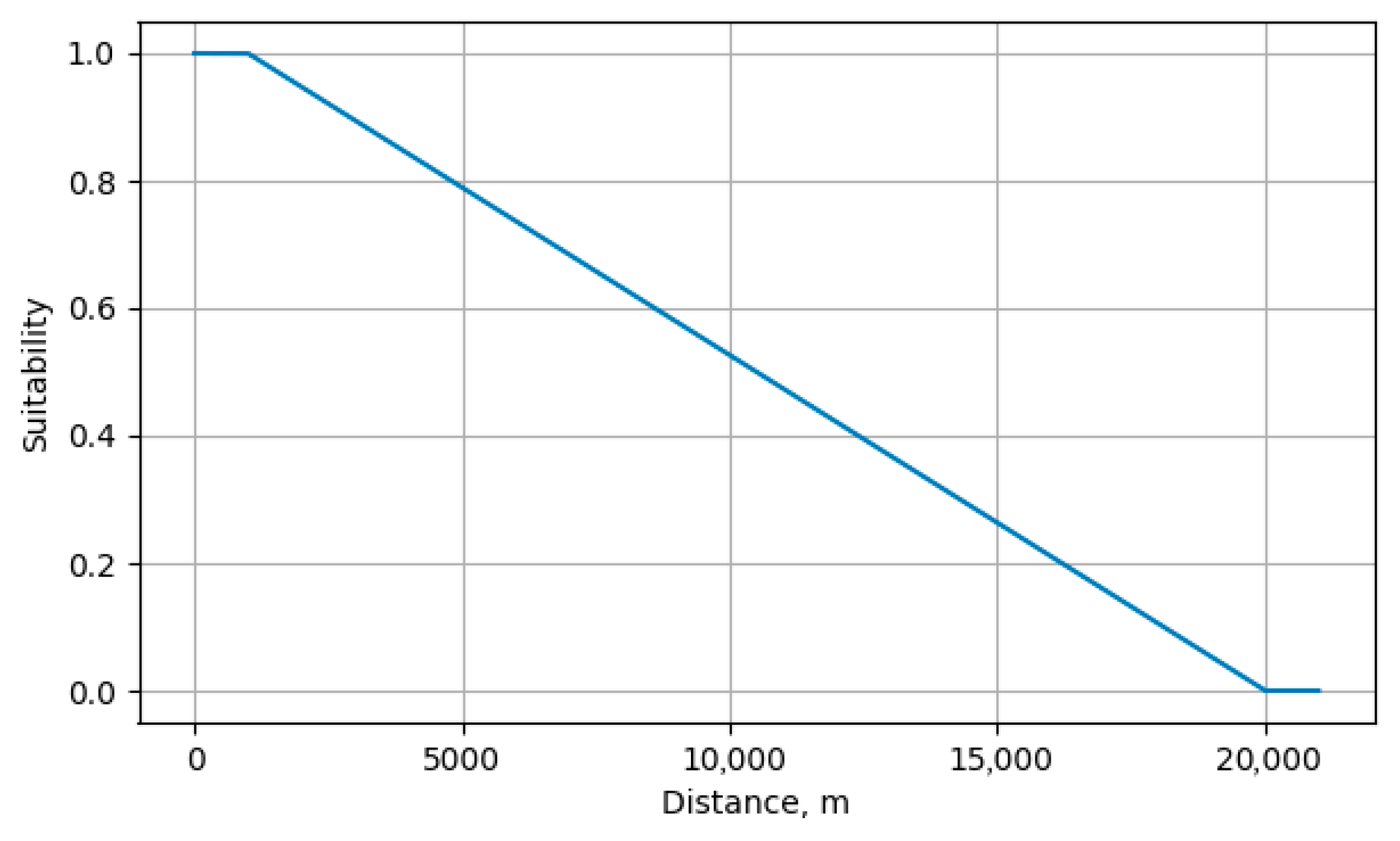
- The values for the criterion “Distance from highways” were calculated by constructing a distance matrix (Vector → Analysis → Distance matrix) between the layers “Samara region map” (QuickOSM plugin, tag boundary/administrative) and “Samara region highway map” (QuickOSM plugin, tag highway/motorway).
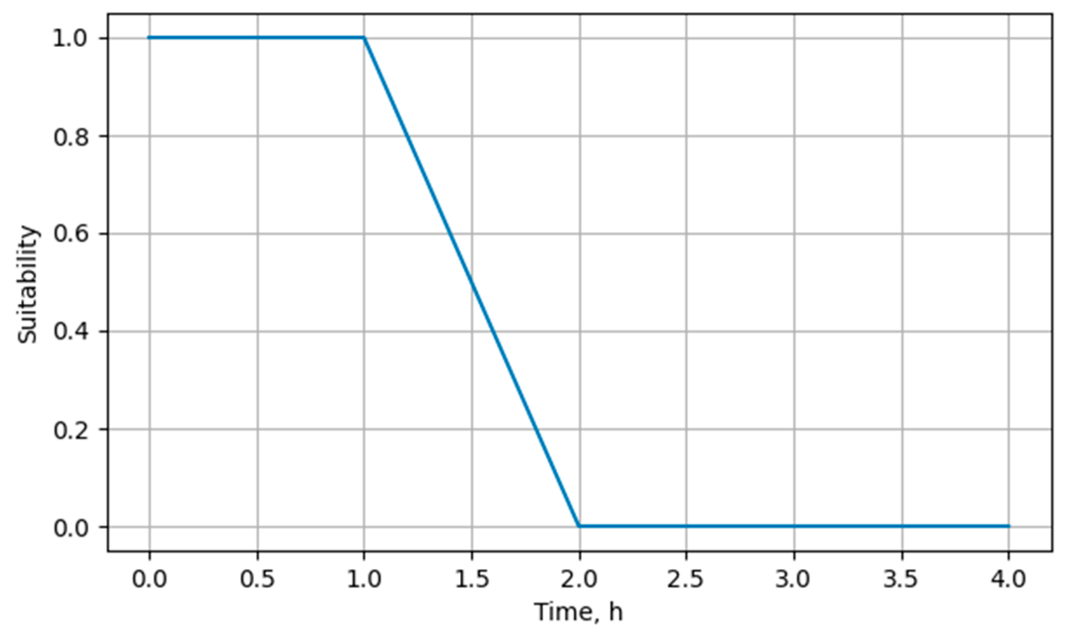
- The values for the criterion “Average travel time” were obtained by averaging (weighted average, where the weight is the city’s population) the results of network analysis (Network analysis → Shortest path (layer to point)) from the layers “Samara region map” and “Samara region road map”. The list of cities (points) was specified manually, including cities with populations exceeding 100,000 people.
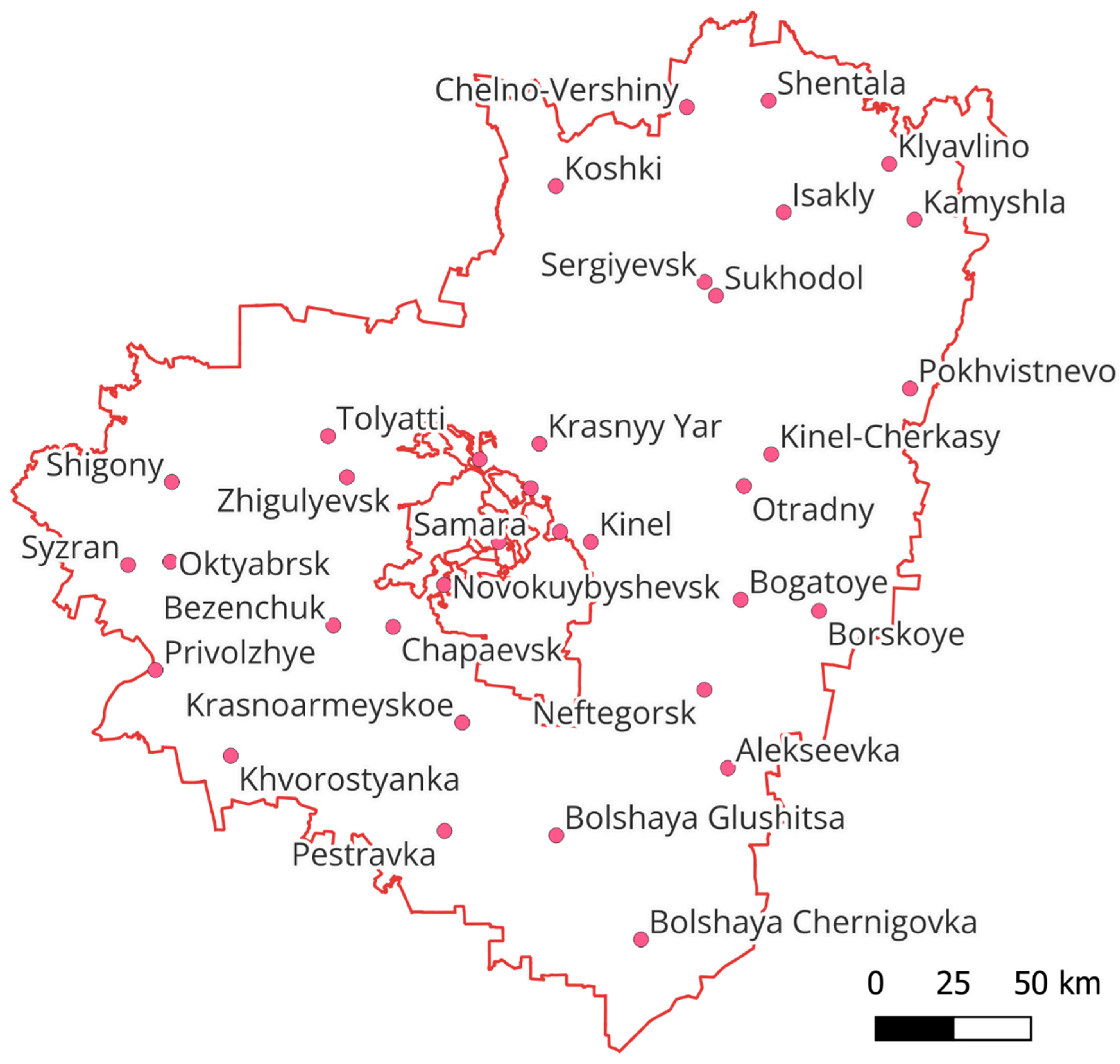
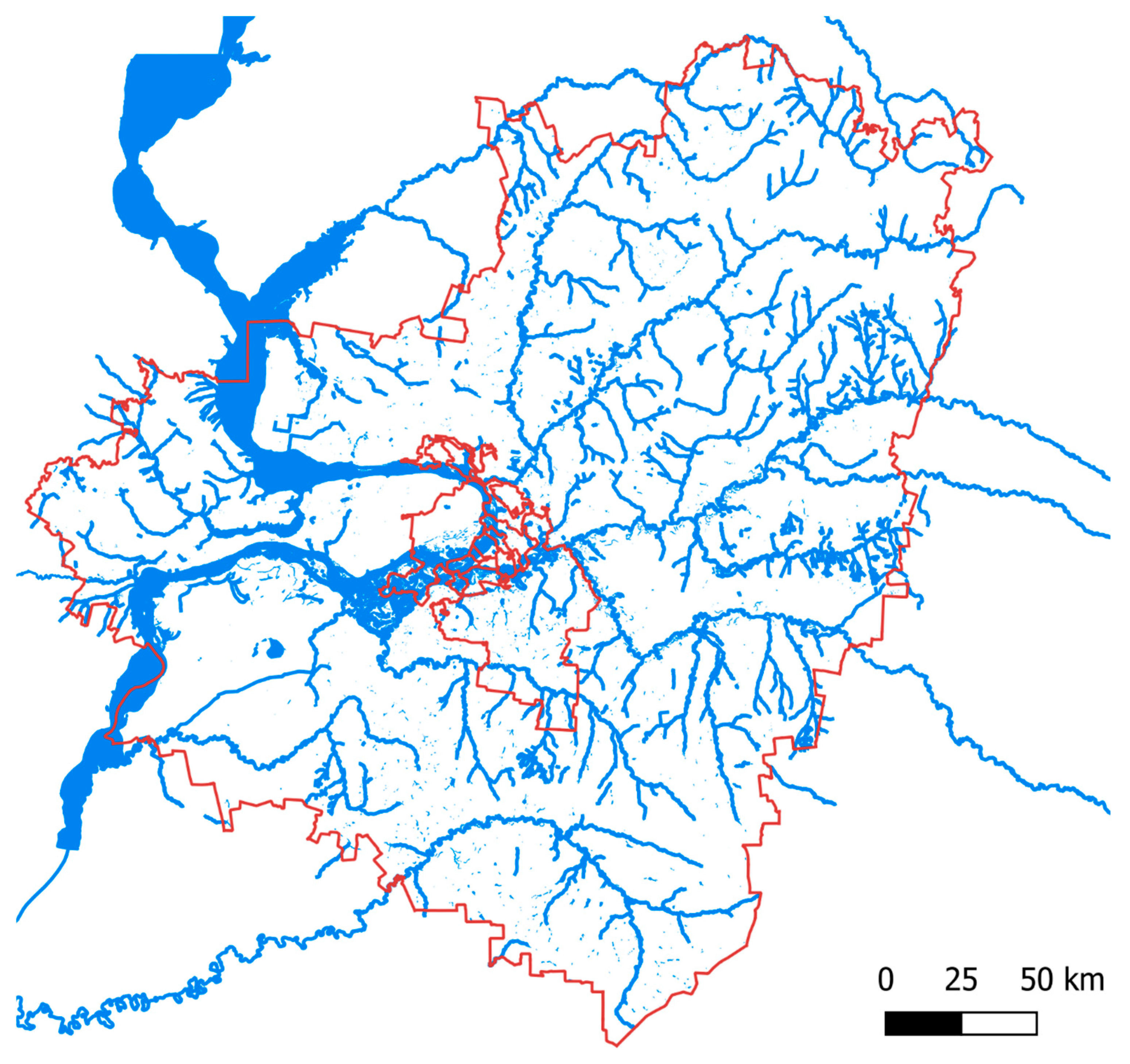
- The values for the criterion “Distance to protected areas” were determined by constructing a distance matrix between the layers “Samara region map”, “map of water bodies” (QuickOSM plugin, tag waterway), and “map of protected objects” (plugin rosreestr-search-qgis Natural territories/Specially protected natural territories and Territories of cultural heritage sites of the people of the Russian Federation). The map of protected objects was converted from raster to vector (Raster → Conversion → Create polygons (raster to vector)).
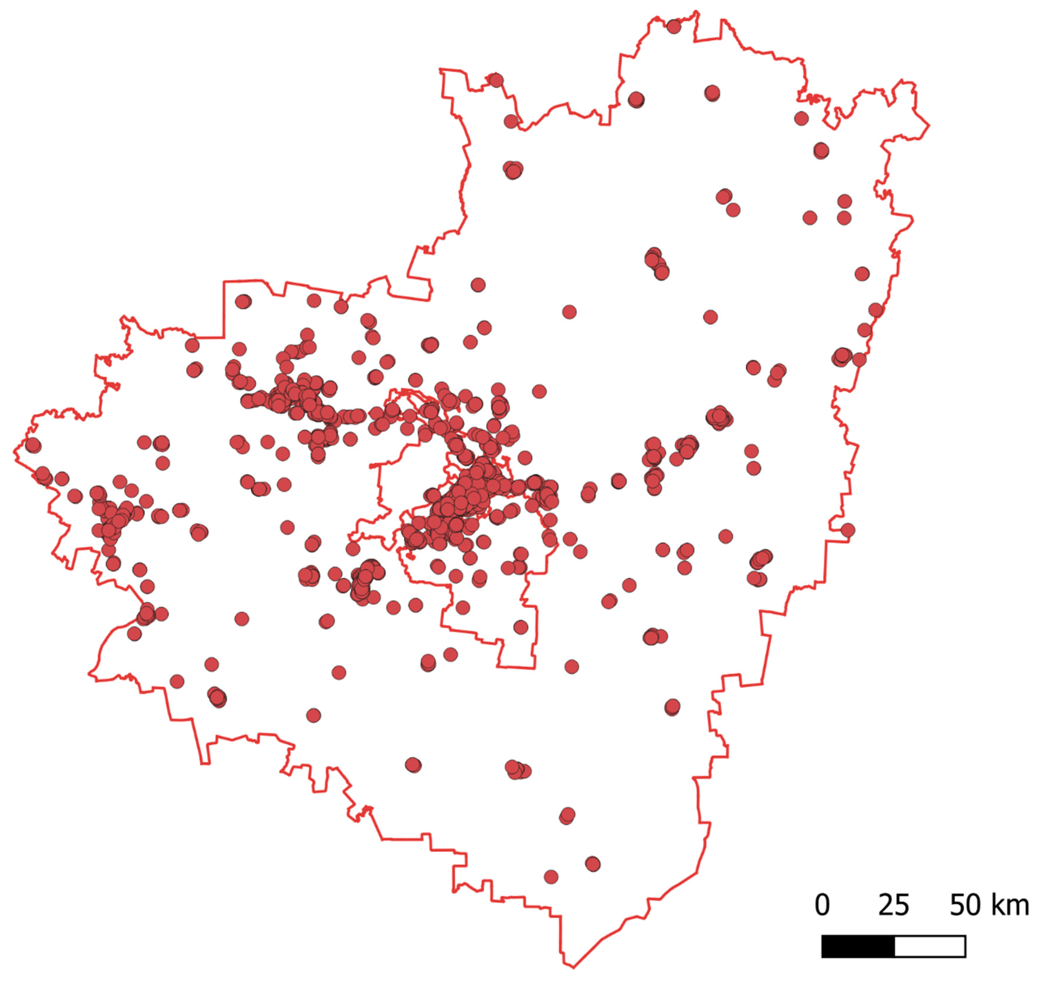
- The values for the criterion “Average distance to the pick-up point” were calculated by averaging (arithmetic mean) the results of network analysis from the layers “map of Samara region” and “map of roads of the Samara region”. The list of pick-up points was created from the “map of pick-up points”, and the pick-up points were clustered to reduce the number of calculations using the ClusterPoints plugin (clustering into 10 groups).
5. Results and Their Use for Spatial Decision-Making
6. Discussion of Results and Conclusions
Author Contributions
Funding
Data Availability Statement
Conflicts of Interest
Correction Statement
References
- Foroozesh, F.; Monavari, S.M.; Salmanmahiny, A.; Robati, M.; Rahimi, R. Assessment of sustainable urban development based on a hybrid decision- making approach: Group fuzzy BWM, AHP, and TOPSIS–GIS. Sustain. Cities Soc. 2022, 76, 103402. [Google Scholar] [CrossRef]
- Abramov, A.; Gorik, U.; Velichko, A.; Nelyub, V.; Samoshkin, A.; Gantimurov, A.; Malashin, I. Barabási–Albert-Based Network Growth Model to Sustainable Urban Planning. Sustainability 2025, 17, 1095. [Google Scholar] [CrossRef]
- Keenan, P.B.; Jankowski, P. Spatial decision support systems: Three decades on. Decis. Support Syst. 2019, 116, 64–76. [Google Scholar] [CrossRef]
- Worral, L. Spatial Analysis and Spatial Policy Using Geographic Information Systems; Belhaven Press: London, UK, 1991. [Google Scholar]
- Rikalovic, A.; Cosic, I.; Lazarevic, D. GIS based multi-criteria analysis for industrial site selection. Procedia Eng. 2014, 69, 1054–1063. [Google Scholar] [CrossRef]
- Malczewski, J. GIS-based land-use suitability analysis: A critical overview. Prog. Plan. 2004, 62, 3–65. [Google Scholar] [CrossRef]
- Razumovskaia, E.; Yuzvovich, L.; Kniazeva, E.; Klimenko, M.; Shelyakin, V. The effectiveness of Russian government policy to support changes in the COVID-19 pandemic. J. Open Innov. Technol. Mark. Complex. 2020, 6, 160. [Google Scholar] [CrossRef]
- Li, Z.; Li, T. Economic sanctions and regional differences: Evidence from sanctions on Russia. Sustainability 2022, 14, 6112. [Google Scholar] [CrossRef]
- Mandziuk, A.A. Digital trade offering new challenges and opportunities for Russia. Russ. Particip. Int. Trade 2021, 1, 133–140. [Google Scholar]
- Osypa, A.; Pogodin, S.; Matveevskaya, A. Problems and Prospects of Promoting Digital Trade in Russia. In Proceedings of Topical Issues in International Political Geography; Springer: Cham, Switzerland, 2021; pp. 102–111. [Google Scholar]
- Xu, Y.; Li, Y.; Zheng, L.; Cui, L.; Li, S.; Li, W.; Cai, Y. Site selection of wind farms using GIS and multi-criteria decision making method in Wafangdian, China. Energy 2020, 207, 118222. [Google Scholar] [CrossRef]
- Li, Y.; Zhang, R.; Jiang, D. Order-Picking Efficiency in E-Commerce Warehouses: A Literature Review. J. Theor. Appl. Electron. Commer. Res. 2022, 17, 1812–1830. [Google Scholar] [CrossRef]
- Demirel, T.; Demirel, N.Ç.; Kahraman, C. Multi-criteria warehouse location selection using Choquet integral. Expert Syst. Appl. 2010, 37, 3943–3952. [Google Scholar] [CrossRef]
- Cui, L.; Xu, Y.; Xu, L.; Huang, G. Wind Farm Location Special Optimization Based on Grid GIS and Choquet Fuzzy Integral Method in Dalian City, China. Energies 2021, 14, 2454. [Google Scholar] [CrossRef]
- Montgomery, B.; Dragićević, S.; Dujmović, J.; Schmidt, M. A GIS-based Logic Scoring of Preference method for evaluating land capability and suitability for agriculture. Comput. Electron. Agric. 2016, 124, 340–353. [Google Scholar] [CrossRef]
- Krsnik, G.; Reynolds, K.M.; Murphy, P.; Paplanus, S.; Garcia-Gonzalo, J.; Olabarría, J.R.G. Forest use suitability: Towards decision-making-oriented sustainable management of forest ecosystem services. Geogr. Sustain. 2023, 4, 414–427. [Google Scholar] [CrossRef]
- Haske, B.; Al Heib, M.; Inojosa, V.; Bouaziz, M. Spatial Decision Support System for Multi-Risk Assessment of Post-Mining Hazards. Mining 2025, 5, 17. [Google Scholar] [CrossRef]
- Rane, N.L.; Achari, A.; Hashemizadeh, A.; Phalak, S.; Pande, C.B.; Giduturi, M.; Yadav, K.K. Identification of sustainable urban settlement sites using interrelationship based multi-influencing factor technique and GIS. Geocarto Int. 2023, 38, 1–27. [Google Scholar] [CrossRef]
- Tholo, H.M.; Kadewa, W.; Chisenga, C.; Gondwe, S.; Zuza, E.; Mwase, W.; Nyengere, J. Web-based spatial decision support system for optimal route to forest fires: A case of Viphya plantations. Trees For. People 2025, 19, 100740. [Google Scholar] [CrossRef]
- Ayele, A.B.; Tura, A.L.; Utallo, A.U.; Mekonnen, A.G. Spatial assessments of landslide hazard vulnerability using decision support system in the Sile-Sago Watershed, Lake Chamo Rift Valley Basin, Ethiopia. Environ. Chall. 2025, 18, 101057. [Google Scholar] [CrossRef]
- Cotrina-Sanchez, A.; García, L.; Calle, C.; Sari, F.; Bandopadhyay, S.; Rojas-Briceño, N.B.; Oliva, M. Multicriteria Analysis in Apiculture: A Sustainable Tool for Rural Development in Communities and Conservation Areas of Northwest Peru. Land 2023, 12, 1900. [Google Scholar] [CrossRef]
- Candido, L.A.; Coêlho, G.A.G.; de Moraes, M.M.G.A.; Florêncio, L. Review of decision support systems and allocation models for integrated water resources management focusing on joint water quantity-quality. J. Water Resour. Plan. Manag. 2022, 148, 03121001. [Google Scholar] [CrossRef]
- Hammond, E.B.; Coulon, F.; Hallett, S.H.; Thomas, R.; Hardy, D.; Kingdon, A.; Beriro, D.J. A critical review of decision support systems for brownfield redevelopment. Sci. Total Environ. 2021, 785, 147132. [Google Scholar] [CrossRef]
- Díaz, H.; Soares, C.G. An integrated GIS approach for site selection of floating offshore wind farms in the Atlantic continental European coastline. Renew. Sustain. Energy Rev. 2020, 134, 110328. [Google Scholar] [CrossRef]
- Wen, R.; Li, S. Spatial Decision Support Systems with Automated Machine Learning: A Review. ISPRS Int. J. Geo–Inf. 2022, 12, 12. [Google Scholar] [CrossRef]
- Arrogante-Funes, P.; Bruzón, A.G.; Arrogante-Funes, F.; Ramos-Bernal, R.N.; Vázquez-Jiménez, R. Integration of vulnerability and hazard factors for landslide risk assessment. Int. J. Environ. Res. Public Health 2021, 18, 11987. [Google Scholar] [CrossRef] [PubMed]
- Das, S.; Li, J.J.; Allston, A.; Kharfen, M. Planning area-specific prevention and intervention programs for HIV using spatial regression analysis. Public Health 2019, 169, 41–49. [Google Scholar] [CrossRef] [PubMed]
- Li, K.Y.; de Lima, R.S.; Burnside, N.G.; Vahtmäe, E.; Kutser, T.; Sepp, K.; Sepp, K. Toward automated machine learning-based hyperspectral image analysis in crop yield and biomass estimation. Remote Sens. 2022, 14, 1114. [Google Scholar] [CrossRef]
- D’Orazio, V.; Lin, Y. Forecasting conflict in Africa with automated machine learning systems. Int. Interact. 2022, 48, 714–738. [Google Scholar] [CrossRef]
- Sachit, M.S.; Shafri, H.Z.M.; Abdullah, A.F.; Rafie, A.S.M.; Gibril, M.B.A. Global Spatial Suitability Mapping of Wind and Solar Systems Using an Explainable AI-Based Approach. ISPRS Int. J. Geo-Inf. 2022, 11, 422. [Google Scholar] [CrossRef]
- Gergin, R.E.; Peker, I. Literature review on success factors and methods used in warehouse location selection. Pamukkale Univ. Mühendislik Bilim. Derg. 2019, 25, 1062–1070. [Google Scholar] [CrossRef]
- He, Y.; Wang, X.; Lin, Y.; Zhou, F.; Zhou, L. Sustainable decision making for joint distribution center location choice. Transp. Res. Part D Transp. Environ. 2017, 55, 202–216. [Google Scholar] [CrossRef]
- Mousavi, S.M. A new interval-valued hesitant fuzzy pairwise comparison–compromise solution methodology: An application to cross-docking location planning. Neural Comput. Appl. 2019, 31, 5159–5173. [Google Scholar] [CrossRef]
- Singh, R.K.; Chaudhary, N.; Saxena, N. Selection of warehouse location for a global supply chain: A case study. IIMB Manag. Rev. 2018, 30, 343–356. [Google Scholar] [CrossRef]
- Vlachopoulou, M.; Silleos, G.; Manthou, V. Geographic information systems in warehouse site selection decisions. Int. J. Prod. Econ. 2001, 71, 205–212. [Google Scholar] [CrossRef]
- Huifeng, J.; Aigong, X. The method of warehouse location selection based on GIS and remote sensing images. Proc. Int. Arch. Photogramm. Remote Sens. Spat. Inf. Sci. XXXVII Part B 2008, 2, 545–548. [Google Scholar]
- Chen, C. A decision model of field depot location based on the centrobaric method and analytical hierarchy process (AHP). Int. J. Bus. Manag. 2009, 4, 71–75. [Google Scholar] [CrossRef]
- Ou, C.W.; Chou, S.Y. International distribution center selection from a foreign market perspective using a weighted fuzzy factor rating system. Expert Syst. Appl. 2009, 36, 1773–1782. [Google Scholar] [CrossRef]
- Maharjan, R.; Hanaoka, S. Warehouse location determination for humanitarian relief distribution in Nepal. Transp. Res. Procedia 2017, 25, 1151–1163. [Google Scholar] [CrossRef]
- Pajić, V.; Andrejić, M.; Jolović, M.; Kilibarda, M. Strategic warehouse location selection in business logistics: A novel approach using imf SWARA–MARCOS—A case study of a Serbian logistics service provider. Mathematics 2024, 12, 776. [Google Scholar] [CrossRef]
- Jha, M.K.; Raut, R.D.; Gardas, B.B.; Raut, V. A sustainable warehouse selection: An interpretive structural modeling approach. Int. J. Procure. Manag. 2018, 11, 201–232. [Google Scholar] [CrossRef]
- Limonov, L.; Batchaev, A. Strategic Planning in Russia: From National to Local Government Approaches. In Shaping Regional Futures: Designing and Visioning in Governance Rescaling; Springer: Cham, Switzerland, 2020; pp. 133–144. [Google Scholar]
- Khandazhapova, L.M.; Lubsanova, N.B. Problems of sustainable development of rural areas of Russia in regional research. Natl. Interes. Priorities Saf. 2015, 21, 25–32. [Google Scholar]
- Kotov, V. Russia: Historical dimensions of water management. In The Evolution of the Law and Politics of Water; Springer: Dordrecht, The Netherlands, 2009; pp. 139–155. [Google Scholar]
- Spector, L.; Malyutin, A. Research of Legal Protection of the Aquatic Environment in the Territory of the Russian Federation. In International Scientific Conference on Agricultural Machinery Industry “Interagromash”; Springer: Cham, Switzerland, 2022; pp. 1617–1625. [Google Scholar]
- Bykowa, E.; Dyachkova, I. Modeling the size of protection zones of cultural heritage sites based on factors of the historical and cultural assessment of lands. Land 2021, 10, 1201. [Google Scholar] [CrossRef]
- Durmuş, A.; Turk, S.S. Factors influencing location selection of warehouses at the intra-urban level: Istanbul case. Eur. Plan. Stud. 2014, 22, 268–292. [Google Scholar] [CrossRef]
- Bushmakina, Y.V.; Balyberdina, P.A.; Dmitrieva, M.K.; Gogoleva, M.V. The use of GIS for studying cultural heritage and urban historical landscape: The case of Perm and Usolie (Russia). Ge-conservacion 2017, 1, 26. [Google Scholar]
- Özcan, T.; Çelebi, N.; Esnaf, Ş. Comparative analysis of multi-criteria decision making methodologies and implementation of a warehouse location selection problem. Expert Syst. Appl. 2011, 38, 9773–9779. [Google Scholar] [CrossRef]
- You, M.; Xiao, Y.; Zhang, S.; Yang, P.; Zhou, S. Optimal mathematical programming for the warehouse location problem with Euclidean distance linearization. Comput. Ind. Eng. 2019, 136, 70–79. [Google Scholar] [CrossRef]
- Cetinkaya, C.; Özceylan, E.; Keser, I. A GIS-based AHP approach for emergency warehouse site selection: A case close to Turkey-Syria border. J. Eng. Res. 2022, 10, 250–273. [Google Scholar]
- Sánchez-Lozano, J.M.; Antunes, C.H.; García- Cascales, M.S.; Dias, L.C. GIS-based photovoltaic solar farms site selection using ELECTRE-TRI: Evaluating the case for Torre Pacheco, Murcia, Southeast of Spain. Renew. Energy 2014, 66, 478–494. [Google Scholar] [CrossRef]
- Raskin, J. The Humane Interface: New Directions for Designing Interactive Systems; Addison-Wesley Professional: Boston, MA, USA, 2000. [Google Scholar]
- Detyniecki, M. Fundamentals on Aggregation Operators. 2001. Available online: https://webia.lip6.fr/~marcin/web/wp-content/papercite-data/pdf/Detyniecki_AGOP_2001.pdf (accessed on 17 February 2024).
- Aytekin, A. Comparative analysis of the normalization techniques in the context of MCDM problems. Decis. Mak. Appl. Manag. Eng. 2021, 4, 1–25. [Google Scholar] [CrossRef]
- Mukhametzyanov, I. On the conformity of scales of multidimensional normalization: An application for the problems of decision making. Decis. Mak. Appl. Manag. Eng. 2023, 6, 341–399. [Google Scholar] [CrossRef]
- Robinson, D.T.; Caradima, B. A multi-scale suitability analysis of home-improvement retail-store site selection for Ontario, Canada. Int. Reg. Sci. Rev. 2023, 46, 69–97. [Google Scholar] [CrossRef]
- Kılcı, F. A Decision Support System for Shelter Site Selection with GIS Integration: Case for Turkey. Ph.D. Thesis, Bilkent Universities, Ankara, Turkey, 2012. [Google Scholar]
- Rahman, M.M.; Szabó, G. Sustainable Urban Land-Use Optimization Using GIS-Based Multicriteria Decision-Making (GIS-MCDM) Approach. ISPRS Int. J. Geo-Inf. 2022, 11, 313. [Google Scholar] [CrossRef]
- Dujmović, J. Aggregation operators and observable properties of human reasoning. In Aggregation Functions in Theory and in Practice, Proceedings of the 7th International Summer School on Aggregation Operators at the Public University of Navarra, Pamplona, Spain, 16–20 July 2013; Springer: Berlin/Heidelberg, Germany, 2013; pp. 5–16. [Google Scholar]
- Dujmovic, J.J. Continuous preference logic for system evaluation. IEEE Trans. Fuzzy Syst. 2007, 15, 1082–1099. [Google Scholar] [CrossRef]
- Grabisch, M.; Roubens, M. Application of the Choquet integral in multicriteria decision making. In Fuzzy Measures and Integrals-Theory and Applications; 2000; pp. 348–374. Available online: https://ikojadin.perso.univ-pau.fr/kappalab/pub/GraRouCOLL2000.pdf (accessed on 25 February 2024).
- Grabisch, M. A graphical interpretation of the Choquet integral. IEEE Trans. Fuzzy Syst. 2000, 8, 627–631. [Google Scholar] [CrossRef]
- Sakulin, S.; Alfimtsev, A. Multicriteria Decision Making in Tourism Industry Based on Visualization of Aggregation Operators. Appl. Syst. Innov. 2023, 6, 74. [Google Scholar] [CrossRef]
- Grabisch, M. K-order additive discrete fuzzy measures and their representation. Fuzzy Sets Syst. 1997, 92, 167–189. [Google Scholar] [CrossRef]
- Mayag, B.; Grabisch, M.; Labreuche, C. A representation of preferences by the Choquet integral with respect to a 2-additive capacity. Theory Decis. 2011, 71, 297–324. [Google Scholar] [CrossRef]
- Kojadinovic, I. Minimum variance capacity identification. Eur. J. Oper. Res. 2007, 177, 498–514. [Google Scholar] [CrossRef]
- Available online: https://pimsolutions.ru/rating.html (accessed on 13 April 2025).
- Leptyukhova, O.Y. Analysis of the set of rules “Urban development. Planning and development of urban and rural settlements” and its importance in modern urban planning. Ecol. Urban. Territ. 2020, 3, 98–104. (In English) [Google Scholar]
- Available online: https://opentopography.org/ (accessed on 20 April 2025).
- Krishnan, S.; Crosby, C.; Nandigam, V.; Phan, M.; Cowart, C.; Baru, C.; Arrowsmith, R. OpentoPography: A services oriented architecture for community access to LIDAR topography. In Proceedings of the 2nd International Conference on Computing for Geospatial Research & Applications, Washington, DC, USA, 23–25 May 2021; pp. 1–8. [Google Scholar]
- Cerba, O. OpenStreetMap as the Data Source for Territorial Innovation Potential Assessment. ISPRS Int. J. Geo-Inf. 2025, 14, 127. [Google Scholar] [CrossRef]
- Awad, A.M.; Wikantika, K.; Ali, H.; Abujayyab, S.K.; Hashempour, J. Optimization of new fire department location using an improved GIS algorithm for firefighters travel time estimation. Int. J. Emerg. Serv. 2024, 13, 80–97. [Google Scholar] [CrossRef]
- Das, S.; Baral, A.; Rafizul, I.M.; Berner, S. Efficiency enhancement in waste management through GIS-based route optimization. Clean. Eng. Technol. 2024, 21, 100775. [Google Scholar] [CrossRef]
- Abousaeidi, M.; Fauzi, R.; Muhamad, R. Geographic Information System (GIS) modeling approach to determine the fastest delivery routes. Saudi J. Biol. Sci. 2016, 23, 555–564. [Google Scholar] [CrossRef]
- Debnath, P. A QGIS-based road network analysis for sustainable road network infrastructure: An application to the Cachar District in Assam, India. Infrastructures 2022, 7, 114. [Google Scholar] [CrossRef]
- Available online: https://nspd.gov.ru/map (accessed on 23 April 2025).
- Wang, M.; Li, Q.; Hu, Q.; Zhou, M. Quality analysis of open street map data. Int. Arch. Photogramm. Remote Sens. Spat. Inf. Sci. 2013, 40, 155–158. [Google Scholar] [CrossRef]
- Abdi, A.P.; Damci, A.; Turkoglu, H.; Kirca, V.O.; Demirkesen, S.; Sadikoglu, E.; Arslan, A.E. A Geographic Information System-Based Integrated Multi-Criteria Decision-Support System for the Selection of Wind Farm Sites: The Case of Djibouti. Sustainability 2025, 17, 2555. [Google Scholar] [CrossRef]
- Grabisch, M.; Kojadinovic, I.; Meyer, P. A review of methods for capacity identification in Choquet integral based multi-attribute utility theory: Applications of the Kappalab R package. Eur. J. Oper. Res. 2008, 186, 766–785. [Google Scholar] [CrossRef]
- Samokhvalova, E.V.; Zudilin, S.N.; Lavrennikova, O.A. Spatial analysis of Samara region land degradation and differentiation of antierosion territory organization. BIO Web Conf. 2020, 27, 00142. [Google Scholar] [CrossRef]
- Valkov, D.V. Burial mounds of the Samara Region in the focus of satellite images. Samara J. Sci. 2020, 9, 146–159. [Google Scholar] [CrossRef]
- Vasilieva, D.; Parsova, V.; Vlasov, A.; Tarbaev, V. Monitoring of land use and land abandonment at the municipal level: Example of Samara Region. Econ. Sci. Rural. Dev. 2020, 2020, 244–251. [Google Scholar]
- Zhichkin, K.A.; Vorob’Eva, D.A.; Zhichkina, L.N.; Nayanov, A.V.; Kuraev, A.N. Cadastral valuation of agricultural land: Regional practice. In IOP Conference Series: Earth and Environmental Science; IOP Publishing: Bristol, England, 2021; Volume 723, p. 032095. [Google Scholar]
- Hozdić, E.; Butala, P. Concept of socio-cyber-physical work systems for Industry 4.0. Tech. Vjesn. 2020, 27, 399–410. [Google Scholar]
- Kalhori, M.R.N.; Beliakov, G. A Fuzzy Measure and Choquet Integral-Based Approach in the Predictive Knowledge-Based Systems: Application to the Electricity Demand Forecasting. IEEE Trans. Fuzzy Syst. 2025, 33, 1379–1390. [Google Scholar] [CrossRef]
- Zhao, P.; Jimenez, J.R.C.; Brovelli, M.A.; Mansourian, A. Towards geospatial blockchain: A review of research on blockchain technology applied to geospatial data. Agil. GIScience Ser. 2022, 3, 71. [Google Scholar] [CrossRef]


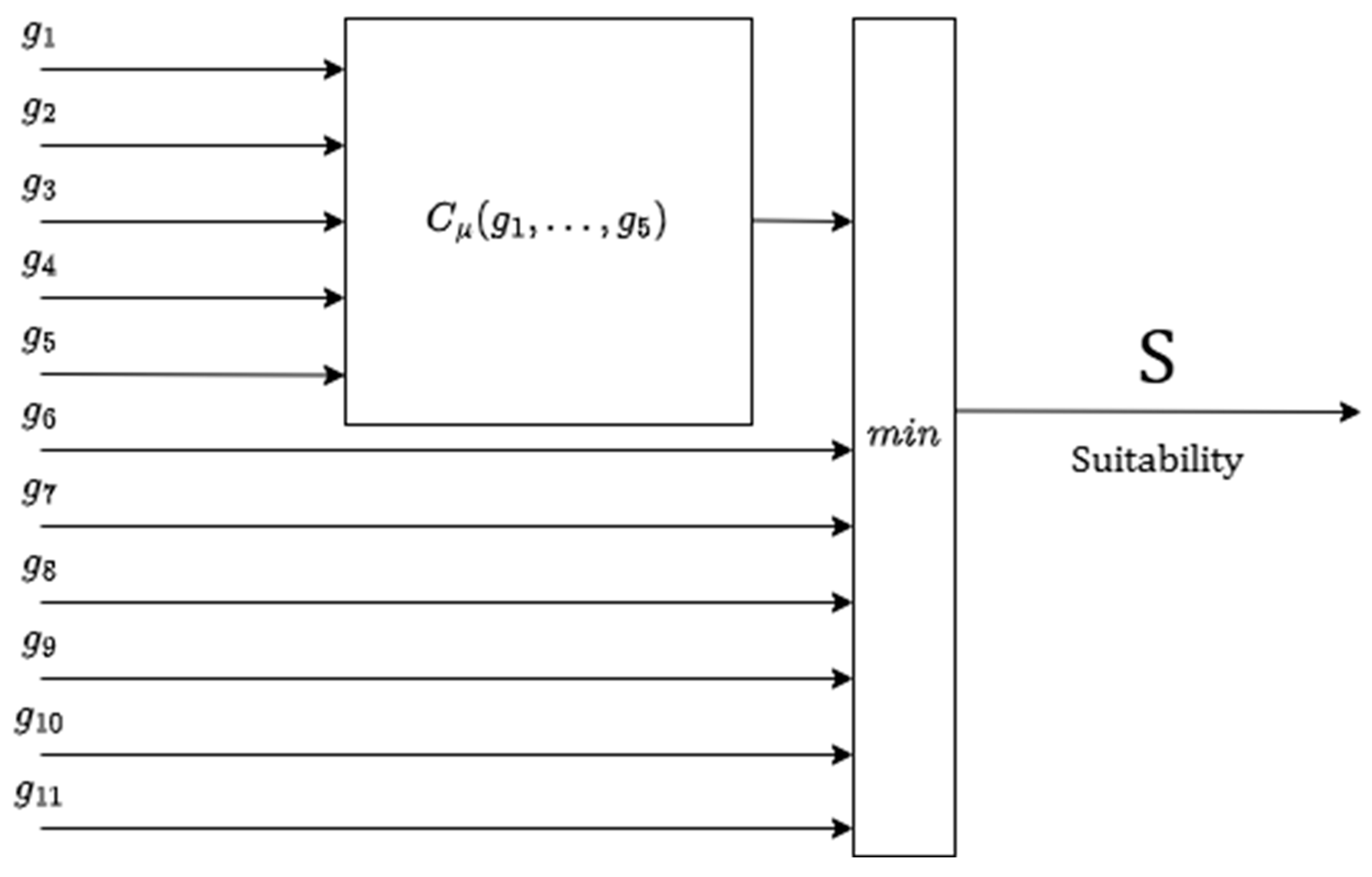
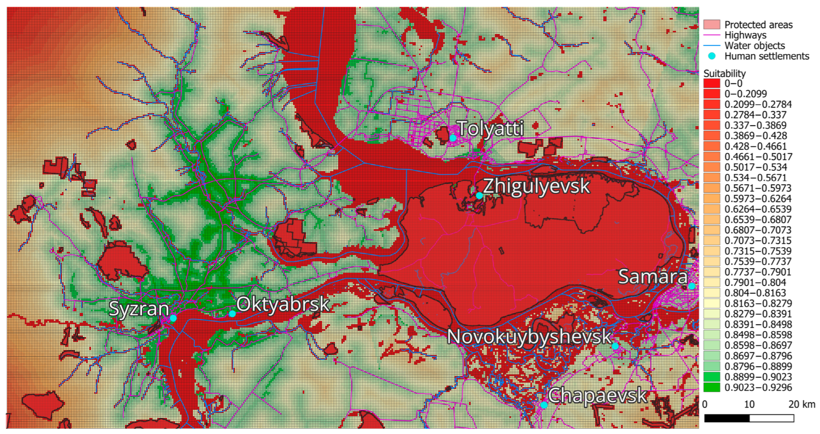


| Criterion | Data Source | Threshold Values | Transformation Function |
|---|---|---|---|
Terrain slope | OpenTopography | 0%; 5%; 8% | |
Distance to highways | OpenStreetMap | 0 km; 1 km; 20 km. | |
Average travel time | OpenStreetMap | 0 h; 1 h; 2 h. | |
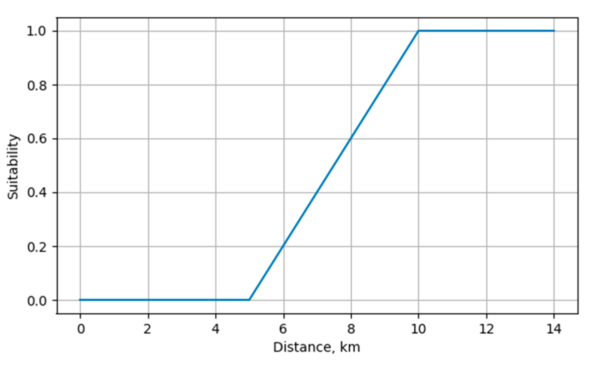
Distance to protected areas | Public Cadastral Map | 0 km; 5 km; 10 km. | |
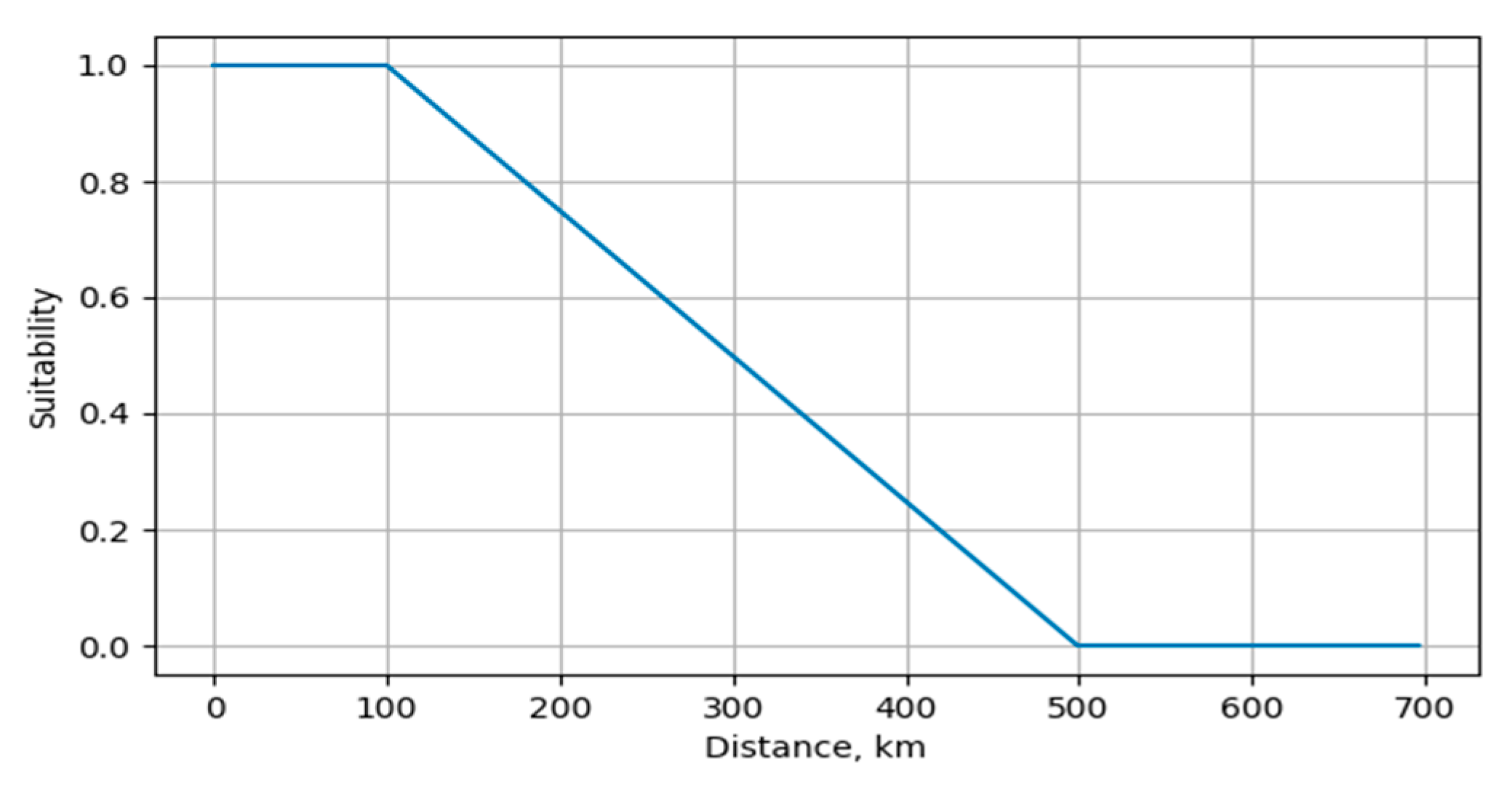
Average distance to pick-up points | OpenStreetMap | 0 km; 100 km; 500 km. | |
Nature reserve | OpenStreetMap | 0; 1 | |
Wildlife sanctuary territory | OpenStreetMap | 0; 1 | |
National park territory | OpenStreetMap | 0; 1 | |
Arboretum territory | OpenStreetMap | 0; 1 | |
Historical heritage site | OpenStreetMap | 0; 1 | |
Water object zone | OpenStreetMap | 0; 1 |
Disclaimer/Publisher’s Note: The statements, opinions and data contained in all publications are solely those of the individual author(s) and contributor(s) and not of MDPI and/or the editor(s). MDPI and/or the editor(s) disclaim responsibility for any injury to people or property resulting from any ideas, methods, instructions or products referred to in the content. |
© 2025 by the authors. Published by MDPI on behalf of the International Society for Photogrammetry and Remote Sensing. Licensee MDPI, Basel, Switzerland. This article is an open access article distributed under the terms and conditions of the Creative Commons Attribution (CC BY) license (https://creativecommons.org/licenses/by/4.0/).
Share and Cite
Sakulin, S.; Alfimtsev, A.; Gavrilov, N. An Approach to Selecting an E-Commerce Warehouse Location Based on Suitability Maps: The Case of Samara Region. ISPRS Int. J. Geo-Inf. 2025, 14, 326. https://doi.org/10.3390/ijgi14090326
Sakulin S, Alfimtsev A, Gavrilov N. An Approach to Selecting an E-Commerce Warehouse Location Based on Suitability Maps: The Case of Samara Region. ISPRS International Journal of Geo-Information. 2025; 14(9):326. https://doi.org/10.3390/ijgi14090326
Chicago/Turabian StyleSakulin, Sergey, Alexander Alfimtsev, and Nikita Gavrilov. 2025. "An Approach to Selecting an E-Commerce Warehouse Location Based on Suitability Maps: The Case of Samara Region" ISPRS International Journal of Geo-Information 14, no. 9: 326. https://doi.org/10.3390/ijgi14090326
APA StyleSakulin, S., Alfimtsev, A., & Gavrilov, N. (2025). An Approach to Selecting an E-Commerce Warehouse Location Based on Suitability Maps: The Case of Samara Region. ISPRS International Journal of Geo-Information, 14(9), 326. https://doi.org/10.3390/ijgi14090326


