Abstract
Urbanization, climate change, and the need for sustainable development are critical challenges facing cities worldwide. The United Nations’ Sustainable Development Goal 11 emphasizes the importance of creating inclusive, safe, resilient, and sustainable settlements. In Saudi Arabia, where urban expansion is accelerating, achieving sustainable cities requires an understanding of urban livability and effective navigation systems. This study explores the role of street legibility in enhancing urban livability and facilitating sustainable urban development. Through a mixed-methods approach, including a literature review and a survey of 295 households, this study assesses the effectiveness of Saudi Arabia’s street addressing system (SAS) based on 14 key legibility criteria. The analysis reveals that while 85.1% of participants are aware of their home addresses, only 25.8% have memorized them, and just 15.6% rely on the SAS for navigation. For navigation, most respondents opt for alternatives like sharing GPS locations (81.4%) or making calls (6.1%). The SAS met 2 of the 14 legibility criteria, partially fulfilled 4, and failed to meet 8, highlighting critical deficiencies. This study recommends simplifying address formats, incorporating street names, and adopting sequential numbering to improve the existing SAS. These insights are essential for urban planners and policymakers to improve street legibility, ultimately fostering more livable and sustainable cities.
1. Introduction
Sustainable development goal (SDG) 11 emphasizes the need for creating sustainable and livable communities by the year 2030 [1]. However, rapid urbanization is one of the greatest challenges of the 21st century undermining urban livability, especially in developing countries with limited financial, technical, and managerial capabilities to effectively manage urban growth [2]. The current and future urbanization challenges have significant implications for urban management and sustainability [3]. As global urbanization accelerates, sustainable development increasingly relies on effective urban growth management and the creation of livable cities [4]. Achieving urban livability requires a significant transformation in how we build and manage urban spaces, as 68% of the global population is expected to live in urban areas by 2050 [5].
Urban livability is the ability of urban spaces, including streets, public squares, and parks, to fulfill the expectations of a quality life for its inhabitants [6]. Streetscapes, as a vital element of urban public spaces, play a key role in shaping cities and fostering urban sustainability [7,8,9,10]. However, in several countries of the Global South, rapid urban growth, automobile-centric urban design, and accelerated urbanization have undermined the livability of urban streets [11,12]. Many cities lack an effective street addressing system (SAS), which plays a critical role in enhancing street legibility—the ease with which streets are recognized, distinguished, and organized into a coherent structure [13]. Street legibility is essential for efficient navigation, a fundamental aspect of urban life, facilitating the movement of people and the delivery of goods and services [14,15]. Moreover, a well-designed SAS is crucial for urban management and planning [16]. The absence of a legible SAS causes millions of urban residents to face challenges in navigation—such as finding and following routes between locations—and in accessing vital services [17]. It also complicates daily life activities, impacting everything from commuting to service accessibility [18,19].
The research gap identified in this study lies in the lack of comprehensive research on the role of street legibility in promoting livable streets in the Global South [20], particularly in Saudi Arabia, where no prior studies have specifically examined this issue. The existing literature on street addressing systems (SASs) in the Global South, including the Middle East, predominantly focuses on technology-related aspects, such as the role of GPS systems in locating addresses [21], analytical frameworks for street livability [22], the impact of street reference data on geocoding accuracy [23], GIS geocoding challenges [24], automation and visualization of address models [25], hybrid SAS models based on Arabic and Indian numerical postal codes [26], and the inefficiencies of postal delivery systems affecting e-commerce [27]. Additionally, one study explored how the absence of physical elements like street furniture, pedestrian walkways, landscaping, and accessibility for disabled individuals undermines street livability [28]. However, these studies either take the structure of the existing SAS for granted or focus on specific technical or physical aspects, neglecting the broader concept of street legibility—defined as the ease with which streets are recognized, distinguished, and organized into a coherent structure—and its impact on urban livability and sustainable urban development.
In the context of Saudi Arabia, this gap is particularly pronounced. The Saudi SAS is widely regarded as illegible, with residents unable to recall home or workplace addresses, relying instead on post office pickups or direct coordination with delivery personnel [29,30]. This illegibility hinders navigation, delivery of goods and services, and reporting of emergencies or utility issues due to its unclear and confusing structure [26,31,32]. Despite the projected urban population growth to 40.71 million (90% of the total population) by 2050, far exceeding the global average of 70% [3], no studies have investigated the underlying factors contributing to the Saudi SAS’s illegibility or proposed solutions to enhance its legibility, scalability, and user-friendliness [29]. Previous research have neither analyzed residents’ perspectives on these challenges nor explored how a legible SAS could support urban livability and sustainable urban development in this rapidly urbanizing context.
This study bridges the identified research gap by conducting a comprehensive assessment of the legibility of the Saudi Arabian SAS and its efficacy for navigation and service delivery, with a focus on residents’ perspectives. Unlike prior studies that focus on technical or isolated aspects of SAS, our research examines street legibility holistically, integrating its role in fostering livable, inclusive cities that enhance community belonging and align with sustainable urban development goals, as outlined in SDG 11 [1]. This study employs a mixed-methods approach, including:
- A literature review to contextualize street legibility within global and regional urban planning frameworks [7,8,9,10,13,14,15,16,17,18,19].
- A questionnaire survey to capture residents’ experiences with the Saudi SAS, addressing issues like address recall, navigation difficulties, and service accessibility [19,29].
- A multi-criteria assessment to evaluate the SAS’s clarity, scalability, and user-friendliness, informed by exemplary SAS cases globally.
By combining these methods, this study not only identifies the factors contributing to the illegibility of Saudi Arabian SAS, but also proposes actionable recommendations for a more legible, effective, and user-friendly SAS. These recommendations aim to improve navigation, service delivery, and urban management, thereby enhancing urban livability and contributing to sustainable urban development in Saudi Arabia, a country facing significant urbanization challenges [3,29].
The rest of this paper is organized as follows. The next section briefly reviews the literature on the relationship between urban livability and street legibility, followed by a brief historical overview and an examination of SAS principles from various countries to identify best practices and approaches. Section 3 describes the methodology employed in surveying residents to identify the challenges with the existing SAS and note their perceptions of essential elements of a legible SAS suitable for Saudi Arabian society. While Section 4 presents and discusses the findings, Section 5 proposes a more legible SAS for cities in Saudi Arabia and other countries with similar socio-cultural and geographical settings. Finally, this study concludes with recommendations, implications for urban planning and management, the limitations of this study, and future research recommendations.
2. Literature Review
2.1. The Role of Street Legibility in Fostering Urban Livability
This section underscores the role of street legibility in promoting urban livability, which is closely aligned to the concept of sustainability. Since the 1960s, Jane Jacobs emphasized the importance of livable streets, which accommodate pedestrians, cyclists, and public space users to build social relationships, improve quality of life, and promote urban sustainability [11]. Livable streets are symbolic public spaces with distinctive character, creating a sense of identity and providing amenities to support a variety of socioeconomic activities [5]. They foster urban livability by enhancing socioeconomic interactions and access to opportunities, as well as by promoting joy, entertainment, creativity, and imagination—offering individuals the chance to experience new things [33]. According to Abdel-Aziz et al. [6], the image of the city and its attractiveness depends on the livability of its streets. Street livability is mainly determined by better integration of the pedestrian’s needs and safety with traffic accessibility in accordance with existing land uses and socioeconomic activities [9,21]. There are four basic principles of a livable streetscape: (a) legibility, (b) accessibility, (c) safety and comfort, and (d) attractiveness [34].
The concept of street legibility was introduced by Kevin Lynch [35], who defined it as “ease with which its parts can be recognized and can be organized into a coherent pattern” [36] (pp. 2–3). It is concerned with the relationships between physical elements or urban components at the street level, essential for facilitating the practical tasks of wayfinding and cognition [36]. Legible streets are easily understandable for users, enhancing how people relate to their surroundings [31]. According to Gakh (2020) [20], street legibility is an integral component of a livable and sustainable city, creating a sense of place and navigable, attractive, and sustainable urban spaces. Street legibility contributes to making cities user-friendly by enabling people to easily navigate around the city and locate events, places, and facilities [37,38].
Countries that develop street design standards adhere to fundamental legibility principles while varying in detail to address local needs. A study on a commercial street in Erbil, Iraq, utilized a framework for placemaking to measure livability using three key dimensions: physical settings, familiarity, and sociability. The physical settings revealed that street width influenced containment and safety, while sidewalks supported uninterrupted movement of people. The familiarity dimension prioritized safety and comfort, emphasizing the prevention of cars encroaching on sidewalks and the ease of street crossing. Sociability highlighted the role of social interaction in enhancing livability [8].
Research in Jordan explores how the physical characteristics of streets influence livability and foster vernacularity, where people can enjoy life and act freely. The finding highlights that street design, signs, and lights are among the crucial elements for creating livable streets. The study proposes a framework to prioritize streetscape principles and variables, guiding municipalities and urban planners in designing streets that enhance livability and promote vernacularity in cities [34].
Street legibility is determined by the SAS implemented in a city, which is both a symbolic part of residents’ identification information and a physical connecting point of one part of the city to another [39,40]. An effective SAS promotes the legibility of streets by making them intelligible, authentic, and meaningful because street addresses are the most common references to places and events in urban areas [12]. For local governments, SAS plays a crucial role in delivering essential services, conducting census activities, and supporting urban planning and management by helping to identify public resources, such as streets (including their length, number, and condition), enabling the establishment of a monitoring system that supports investment planning and boosts municipal revenue [16]. Additionally, it allows utility providers to manage their networks more efficiently, particularly in planning, maintaining, and monitoring water, electricity, and telecommunications systems, as well as in tariff collection [20].
SAS can help meet the accessibility principle of a livable streetscape, as it enhances the ability to reach destinations from various origins for all types of users through street coordinates [16]. It is one of the key accessibility tools for delivering emergency healthcare, fire, police, and parcel and mail services [17]. Similarly, GIS-based navigation applications that generate and use coordinates rely heavily on SAS to provide user access to places as points, polylines, or polygons, and facilitate the analysis and visualization of geospatial data [41]. It is an essential component in realizing the smart city concept [20], as the quality of geocoding relies on street reference data [23].
Street legibility can also help meet the third principle of a livable streetscape by providing safety and comfort to residents [12]. It improves street safety by making it easier for people to understand and navigate their surroundings [42]. Similarly, street safety is enhanced through a sense of ease and orientation, which encourages walkability, social interaction, and economic activities [43]. Lastly, street legibility can make streetscapes more attractive through placemaking and image building [7]. It fosters street attractiveness by creating a sense of belonging, character, and identity, influencing how individuals perceive and interact with their surroundings, giving individuals a sense of control over their environment and balancing individual and community needs [44]. This, in turn, improves navigation, service delivery, and socioeconomic activities [7]. In sum, a legible SAS can help meet all four principles of a livable street by enhancing street identity and image, accessibility, public interaction, safety and overall comfort, and aesthetics, significantly contributing to the creation of more livable and sustainable urban environments.
2.2. Principles of a Legible Street Addressing System (SAS)
A street address is the positional information of a geographical detail of a piece of land on the map, regardless of its land use purpose, which has existed since the 15th century [45]. It is “a number and the name of a street and the name of the town or village, or city and state, for the purpose of identifying a particular building or property” [46]. In France, for example, SAS was simply a reference to local place names or shop signs to make them visible using the name of the most prominent landmarks or popular signs, such as “the inn at Côte Chaude” [47]. However, SAS did not become widely practiced in Europe and its colonies until the 18th century, when the need arose to adopt a system for identifying and locating houses and businesses. This was particularly challenging due to the rapid growth and varying contexts of cities [48,49]. In 1799, Garros was the first to introduce the concept of alternating street numbering, placing even numbers on one side and odd numbers on the other [16]. In 1800, Le Blond proposed a metric system to indicate street length, followed by Huvé in 1801, who suggested a decametric numbering system [16]. Then, in 1802, Mathieu and Belu recommended integrating the street lighting system with house numbering [16].
In the early 19th century in the United Kingdom, residents used towns and county names to reach a specific location. As mail volumes grew in the 1850s, London was divided into postal districts based on the four cardinal directions, a system still in use today. The outer London areas were assigned postal codes N, E, SE, SW, W, and NW, respectively. In a process that was completed in 1934, the system was gradually implemented throughout UK’s other major cities [50]. However, the UK Postmaster General followed the 6-digit postal code that we know today for the first time in 1959 in Norwich. This process continued gradually throughout the 1960s nationwide, introducing postal codes that were finally completed in 1974 [51].
In China, the SAS is based on the four cardinal points of the compass influenced by the classical Chinese philosophy. Within cities, long streets are divided into east-west and north-south, depending on the street’s orientation, which reference to ancient outer walls, or occurring in an arbitrary manner [16]. In Japan, except for a few major roads, streets typically did not have names in the past. Instead, houses were numbered based on their construction date and the block they belonged to, rather than their position on the street. Districts were divided into neighborhoods (chome), each containing several dozen houses, meaning two adjacent houses could have non-sequential numbers. This made it challenging, even for locals, to locate specific addresses, often requiring a visit to the nearest police station for assistance [16]. However, modern cities like Kyoto, which are laid out in a grid system, use sequential numbering. Nine main streets run east to west, starting with Ichijo (1st street) and continuing to Kyujo (9th street), intersected by several avenues [16].
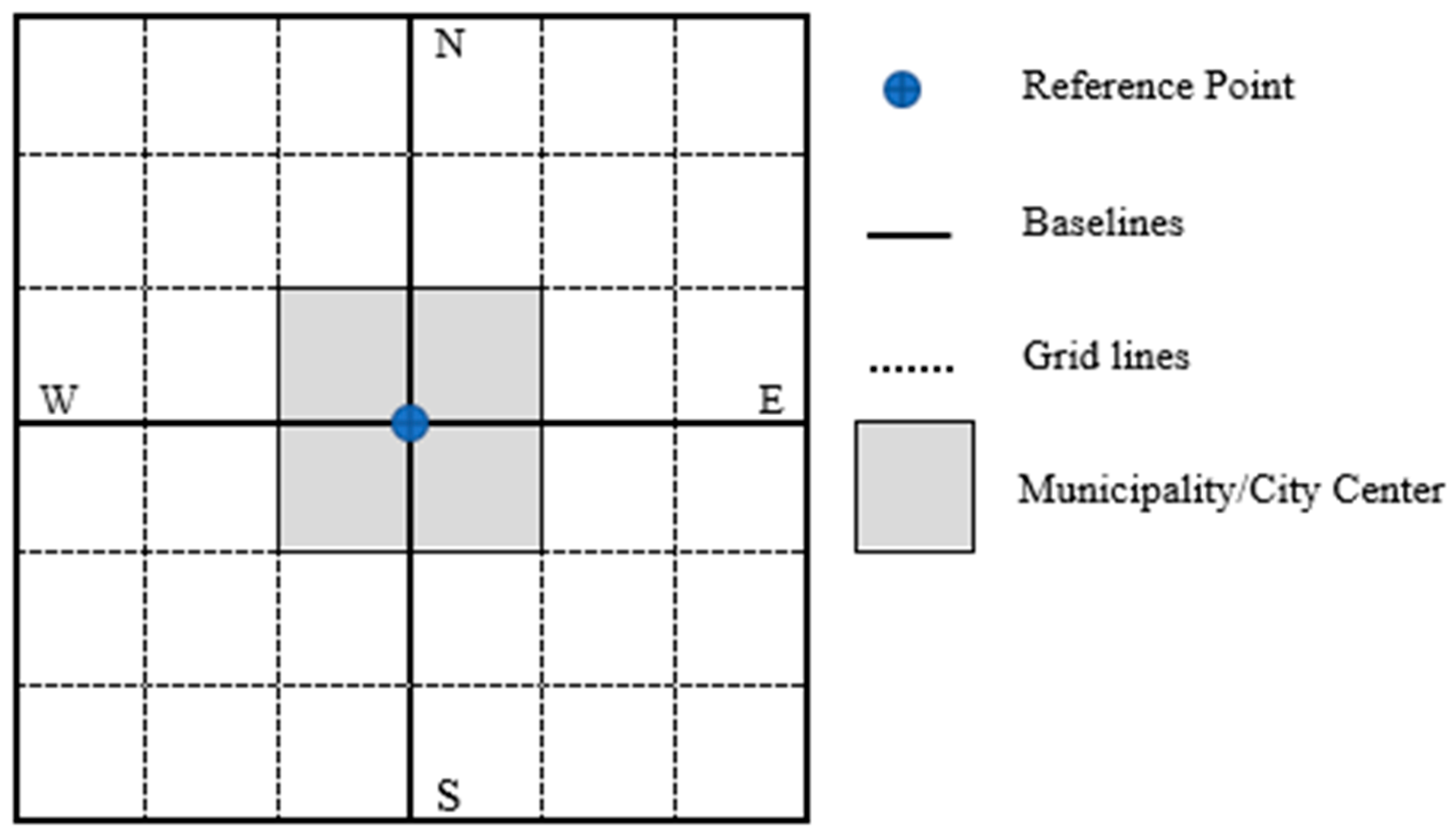
The United States is one of the first countries to develop a more legible SAS, which serves several purposes, including navigation and parcel and mail distribution, as well as census activities [45]. The American Planning Association Report No. 332 introduces the basic elements of this SAS [52]. The first element is the “Reference Point”, typically located at the city center or Central Business District (CBD), from which the street naming and numbering radiate. The approximate location of the reference point is enough to understand the addressing system. The second element is the “Baselines”, which divide the city into four sections or quadrants, often following well-known features such as railroads, lakes, ridges, or major thoroughfares (See Figure 1). Baselines typically originate from or intersect the reference point in primarily east-west and north-south directions, serving as the foundation for SAS [53]. It is recommended that highways serve as baselines, as research shows that well-known landmarks other than thoroughfares are inadequate, since people typically expect baselines to be thoroughfares [54]. The third element consists of the “Grid Lines”, which are imaginary lines constructed perpendicular and parallel to baselines, following the direction of existing streets, when possible, and run down their center [45]. Grid lines help standardize the numbering of parallel blocks by ensuring that blocks at similar distances from the baselines follow a consistent system, with block numbers changing by hundreds at designated intervals. Another advantage is that they can be extended into adjacent vacant areas to dictate the approximate position of new streets, determining the block intervals of the system. The fourth element is the “Block Interval”, which is determined by the distance between major streets, provided they are regularly spaced [52]. If existing major streets are not regularly spaced, the block interval may instead be based on a multiple of “Frontage Units”, which constitute the fifth and the final element of the SAS. A Frontage Unit is a standard interval—typically the width of a lot, measured at its front—used to assign consecutive property numbers on a street, starting from the nearest grid line. Address prefixes in the US system are usually letters preceding the street name and indicating direction (e.g., N. Dallas St.), which could also be written as a whole word (e.g., North Dallas St.) [52]. Suffixes are words or abbreviations that follow a street name, usually indicating the type of street (e.g., Dallas Street or Dallas St.). Streets are often classified by their function and size, with each category assigned a distinct suffix (e.g., avenue, boulevard, way, or place) called thoroughfare designations [52].
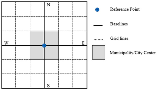
Figure 1.
The basic concept of SAS in the US.
This literature review shows that SASs around the globe vary in form and style. However, a legible SAS has the following features. First, a legible SAS is easy to spell, pronounce, describe, and memorize [16]. Second, it offers user-friendly and logical features, including a linear, hierarchical, universal, and memorable structure [15]. Third, legible streets that are easy to recall provide ease of accessibility and connect people more easily [55]. Lastly, its structural properties facilitate the arrangement of street addresses, requiring robust, extensible, and quarriable codes that are computer-friendly and adaptable for geocoding and navigation applications [56]. In addition to the semantic and structural properties of an address, the cultural and political influences are evident in its application. Many developing countries have adopted a western style SAS, citing globalization, simplicity, and their established history of development. These findings in the literature are particularly important to consider when introducing principles of a successful SAS in rapidly developing countries such as Saudi Arabia.
3. Methodology
3.1. Background of Street Addressing System in Saudi Arabia
Before the establishment of the second Saudi state in 1925, animals were used for navigation and postal services. This era was marked by the absence of clear addressing concepts and a heavy reliance on names of settlements and landmarks, reflecting the simplicity of urban communities and small population size [57]. The second phase was between 1932 and 1980, when postal materials were transported using automobiles, which is associated with rapid urban expansion due to oil exploration activities. During this period, community leaders such as the imam of a mosque, the principal of a school, shop owners, and residents were relied upon to provide directions and building locations for navigation and the delivery of goods and services. The third stage is the introduction of a postal addressing system in the 1980s, which is based on road network data [57]. The system is based on a geographical hierarchy in which administrative divisions constitute the basic element in building the SAS [29]. In 2010, the Saudi Post Corporation issued the unified national SAS [58]. However, the public has not adopted the new system for navigation, reporting accidents, locating properties, or receiving services and deliveries, as it is perceived as inefficient, unclear, and confusing [32].
3.2. Data Collection and Analysis
This study employed a mixed method approach to investigate the legibility of the SAS implemented in Saudi Arabia and recommend a more legible and effective system. In addition to a comprehensive literature review of academic articles and grey literature such as technical reports, government agency websites, theses, and newsletters, this study employed a questionnaire survey from residents. A questionnaire survey is a reliable method for gathering insights into public perceptions and opinions regarding the efficiency of the Saudi Arabian SAS for navigation and the delivery of goods and services [59]. The survey included tailored items carefully adapted from similar studies to assess various aspects of the country’s SAS, including its performance, efficacy, and residents’ perceptions of how its elements align with those of a legible SAS.
The questionnaire consisted of 27 close-ended survey questions. Its design rationale was rooted in a thorough literature review of similar studies and street legibility and urban livability in the Global South. The questions were carefully adapted to align with the specific objectives of this study, which focus on assessing the Saudi Arabian SAS as a crucial factor in street legibility—an essential element in enhancing urban livability and promoting sustainable urban development [11]. The first section of the questionnaire focused on the independent variables (eight items related to respondents’ demographic information): age, gender, marital status, household size, employment type, nationality, education, and income level (Table 1). The second section, consisting of 10 items, explores participants’ knowledge of the existing national SAS in Saudi Arabia, its legibility, and the frequency and ease of use in navigation, accessing goods and services, and daily activities. Participants were asked whether they knew their address and whether they memorized it, with a simple yes or no option. The next question asked those who could not memorize their address to explain their reasons. Other items in the questionnaire solicited information about the efficiency of navigation and the delivery of goods and services at the neighborhood, city, national, and international levels using the SAS. The questions also asked whether respondents required tools other than the SAS to assist with those tasks. For example, inquiries related to whether a delivery person needs additional information, such as sharing participants’ location via smartphone, GPS coordinates, nearby landmarks, phone calls for voice-guided directions, or other arrangements to ensure successful delivery. Finally, an open-ended question solicited any additional issues and recommendations from the participants. The questionnaire was peer-reviewed by two senior colleagues with expertise on the subject to improve content validity and ensure clarity and alignment of items with the study’s objectives. It was then pre-tested in a pilot survey among ten neighbors to further minimize potential misunderstandings of the questions, leading to revisions that enhanced the validity and reliability of the instrument.

Table 1.
Demographic composition of the study participants (n = 295).
Between January and June 2024, the author conducted a cross-sectional online survey of adult residents of Dammam Metropolitan Area (DMA) using the Google Forms platform. The DMA is the capital and largest urban agglomeration in the Eastern Province of Saudi Arabia. It consists of three major cities, Dammam, Khobar, and Dhahran, forming a crucial financial, commercial, industrial, and scientific hub along the Persian/Arabian gulf. It is home to five universities, international airport, Dhahran Techno Valley, the country’s second-largest seaport, tourist attractions, and several multinational oil and gas companies, including Saudi Aramco. The area’s cosmopolitan population of 3.2 million as of 2020 is drawn from all parts of the country, making it a good representative of the Saudi population [59].
The online survey method is quick, economical, and environmentally friendly for data collection [59]. The snowball sampling method was employed, in which participants were asked to share the survey link with people they knew who lived in the study area [60]. By the end of June 2024, a total of 295 respondents had participated in the survey. The snowball method was selected to ensure participants’ anonymity, confidentiality, and to address cultural privacy concerns that undermine questionnaire distribution in Saudi Arabia, particularly among females [60].
Data analysis involved both descriptive statistics (frequency distribution) and inferential statistics (Pearson’s Chi-squared test). The Chi-squared analysis was conducted to determine whether there is a statistically significant association between independent variables (socioeconomic factors such as education, income, and age) and the items in section two of the questionnaire. This method is appropriate since both the independent and dependent variables were categorical, with two or more independent groups [8]. Responses to the final open-ended question were analyzed using thematic content analysis, which involved identifying, organizing, and synthesizing patterns (themes) from participants’ responses. This approach was appropriate for exploring participants’ viewpoints and experiences.
Representativeness of the sample was carefully considered in this study. The demographic characteristics of the respondents closely align with the broader population of Saudi Arabia, suggesting that the findings are relevant and representative. The sample was nearly evenly divided between females (51.5%) and males (48.5%), reflecting the country’s gender distribution [61]. Additionally, the age distribution corresponded to Saudi Arabia’s youthful demographic, with two-thirds of the participants aged 16–40 years, aligning with the national average age of 29 years [58]. The majority (58.3%) of the respondents are married, and approximately 93% are Saudi nationals. More than 55% of the participants are college graduates, and all have attained some level of education, reflecting the country’s literacy rate of 95% [32]. One-third of the participants work in the public sector, while nearly one-third are students; the remainder are employed in the private sector or are self-employed. About half of the participants have household sizes of six or fewer, which is comparable to the country’s average family size of 5.6 [2]. Approximately 29% have 7 to 10 household members, while the rest have more than 10. The regional distribution of respondents is not the primary focus, as this study evaluates a unified SAS across Saudi Arabia within a centralized governmental system. The demographic diversity of the sample ensures that the findings are broadly representative of the population.
4. Results and Discussion
This section presents the results of a survey implemented to explore the perception of residents about the important elements of a legible SAS suitable for urban areas in Saudi Arabia. In this regard, 14 elements of a legible SAS extracted from the literature were used to assess the existing SAS in Saudi Arabia and the findings were synthesized with those from the survey. The triangulated themes were then used to evaluate the SAS, forming the basis for recommendations for a more legible and efficient SAS in Saudi Arabia.
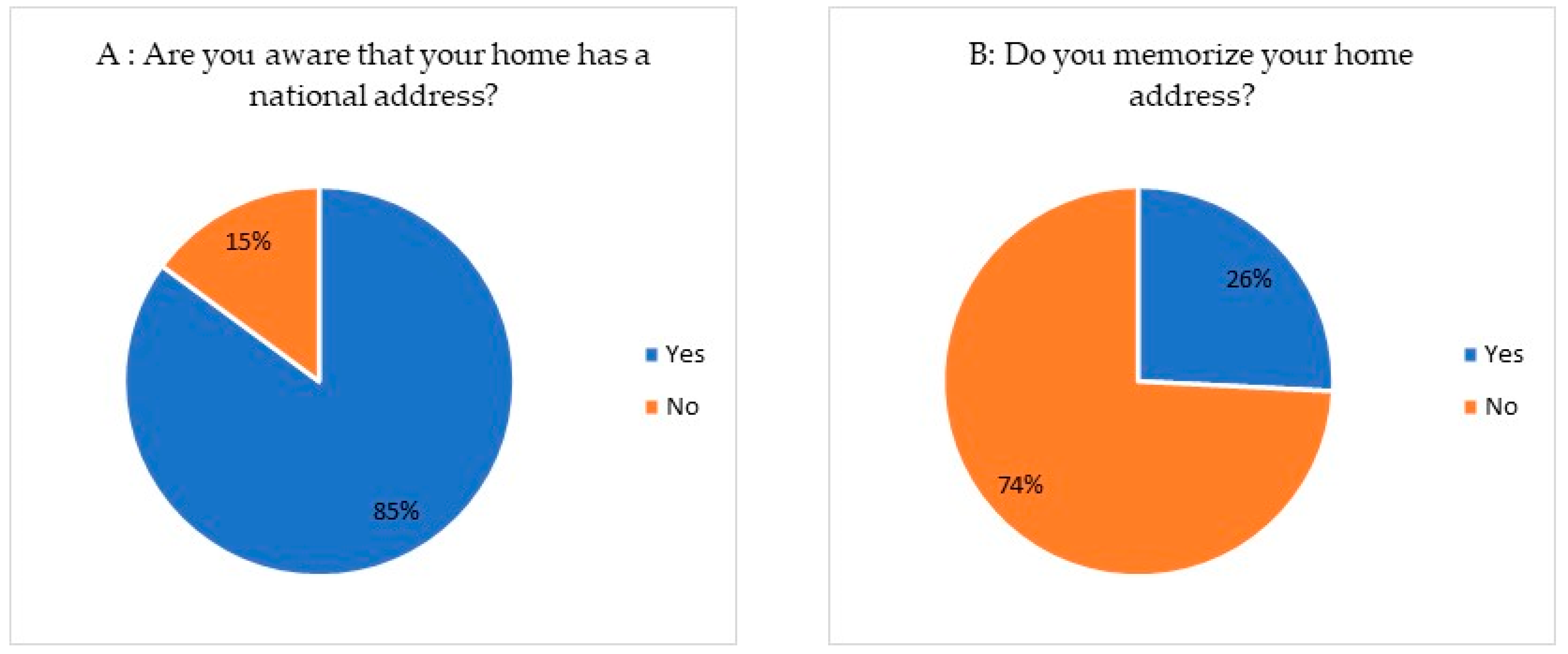
The first principle of a legible SAS is residents’ familiarity with their home addresses. Therefore, two questions were posed: whether their homes had a national address and if they had memorized it. The findings revealed that 85% of participants are aware of their home address, while only 15% were not (Figure 2A). In contrast, only 26% had committed their home address to memory, while the majority (74%) have not done so (Figure 2B). Therefore, participants were then asked about the reasons behind their inability to recall their addresses. Approximately 85% of the responses cited factors such as the address containing numerous digits, a lack of logical organization, and the non-sequential and seemingly random numbering of buildings and houses (Figure 3), making the SAS challenging to memorize.
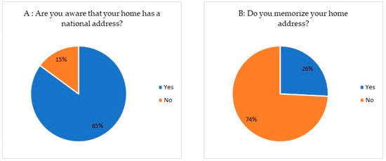
Figure 2.
Residents’ awareness of Saudi Arabian SAS.
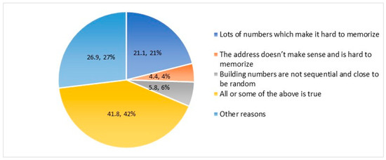
Figure 3.
Residents’ perception of the legibility of Saudi Arabian SAS.
To evaluate the efficacy of the Saudi Arabian SAS for navigation (finding and following a route from one place to another) and delivery purposes, the questionnaire asked residents whether they use it at the neighborhood, city, national, and international levels to navigate from an origin to a destination or for the delivery of goods and services. Regarding their use of the existing SAS for navigation, only 15.6% answered “Yes”, while the vast majority (69.2%) responded “No”, and about 15.2% answered “Sometimes” (Figure 4A). Although a legible SAS helps individuals locate specific places quickly and accurately, over two-thirds of the respondents do not utilize the existing SAS. The greater the accessibility, the more potential locations can be reached within a given time or distance, and the closer the chosen destinations are within this maximum range [8]. Accessibility is crucial for attracting people and fostering social interactions in public open spaces, which in turn contributes to the overall livability of a place [62].
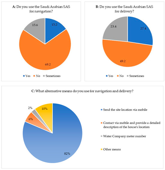
Figure 4.
Residents’ evaluation of the efficacy of the Saudi Arabian SAS for delivering goods and services.
To determine whether there is an association between explanatory and outcome variables, Chi-squared analysis was conducted (Table 2). The results indicate that differences in gender, age, and education significantly influence participants’ awareness and memorization of Saudi SAS. No statistically significant relationship was found between the other independent variables and the outcomes. More females (9.49%) reported awareness of SAS compared to males (5.42%). However, more males (41.36%) remembered their home address compared to females (32.88%). Similarly, the highest awareness was observed among the 18–20 age group (6.44%), which decreased among older participants, particularly those aged 51 and above. However, the relationship between age and home address memorization was not statistically significant (p = 0.130). The highest levels of awareness and memorization were found among undergraduate (10.17% vs. 40.34%) and graduate (2.03% vs. 26.10%) participants, whereas those with lower education (primary/informal, secondary, diploma) had lower awareness and memorization rates. The p-values greater than 0.05 indicate that gender, age, and education play statistically significant roles in awareness and memorization.
Table 2.
Chi-squared analyses of the association between gender, age, and education on some key output variables.
Regarding the use of Saudi Arabian SAS for delivering of goods and services such as parcels, merchandise, or official documents, only 27.5% answered “Yes”. On the contrary, close to half (49.2%) answered “No” while about 23.4% answered “Sometimes” (Figure 4B). For the delivery of parcels, merchandise, and documents at the international level through DHL, ARAMEX, and FedEx, among others, providing a phone number is mandatory in Saudi Arabia. Therefore, the question includes the national address and a phone number. The finding shows that only (36%) of respondents deem the national address combined with the phone number adequate for ensuring successful delivery, with the remaining 64% resorting to alternative arrangements or supplementary information, such as sharing delivery locations via smartphones, to facilitate delivery.
Respondents were asked to elaborate on the alternative methods they use for navigation and delivery. The results show that the majority (81.4%) send their home location via cell phones, 6.1% contact the delivery person or family they are visiting through mobile phones and describe the location of the house, 2.4% use the water company meter service number, and 10.2% use other methods (Figure 4C). Relying on smartphones to send location links can be ineffective. Although it may provide an easy solution to difficulties in locating houses and businesses, it compromises the privacy of personal cell phone numbers and other information that residents may not wish to share but feel compelled to. In addition, such a method may lead to accuracy issues; for example, a demolition crew in 2016 wrongly located a house marked for demolition while relying on their GPS navigation system, resulting in its complete destruction [63]. This case emphasizes the vital role of SAS in daily life and highlights the necessity of making it as simple and logical as possible [19].
The Chi-squared analysis results in Table 3 reveal a statistically significant relationship between respondents’ gender, age, and the use of Saudi SAS for navigation and delivery of goods and services. Other independent variables are not significant at p = 0.05. Males are more likely than females to use SAS for both navigation (47.8% vs. 36.6%) and the delivery of goods and services (44.7% vs. 31.6%). Regarding age, the 31–40 age group has the highest SAS usage for navigation (16.61%), followed by the 21–30 age bracket (12.54%), while the oldest group (61 years and above) has the lowest usage (16.10%). For delivery, the 41–50 age group reports the highest usage (11.19%), followed by the 31–40 group (10.17%), with the least being the 61+ age group (5.08%). The p-values of 0.001 indicate strongly significant associations between gender, age, and the use of Saudi SAS for both navigation and delivery.
Table 3.
Chi-squared analyses of the association between gender and age in the use of Saudi Arabian SAS.
The survey also included three inquiries aimed at determining respondents’ familiarity with names commonly used in a legible SAS. The first question focused on the name of their neighborhood, with an impressive 99% of respondents confidently identifying it. Moving forward, the second question delved into the name of the street they resided on, revealing an 83% retention rate. Lastly, participants were asked about their awareness of the name of the closest major street adjacent to their residence, and approximately 90% accurately recalled the name. These findings underscore the preference for name-based SAS over mere numerical identifiers among the participants.
On the other hand, two questions aimed to measure how comfortable the respondents are with the numbering style used in the Saudi Arabian SAS. The initial question inquired about respondents’ building number, and 35% reported that they did not know the number. The other question concerned knowledge of the building number adjacent to the respondents’ residence, with 78% stating they did not know the answer. The last three questions asked about the participants’ readiness to accept a global, practical, and legible SAS format based on the results of the literature review. The first question asked whether participants preferred an SAS based on three simple and logical pieces of information: building number, street name, and city name. Only 7% opposed this format, while 93% approved of it. The second question explored public attitudes toward a simple and sequential SAS instead of the current system, which uses non-sequential numbering with four or more digits. About 86% supported this suggestion, while only 14% opposed it. Interestingly, in the final question of the survey, 100% of respondents expressed support for having a simple and legible SAS in Saudi Arabia.
These survey findings reveal that most participants are having difficulties using Saudi Arabian SAS for navigation and delivery purposes at local, national, and international levels. It shows that the vast majority must contact the delivery agent or the person visiting their home or the household they are visiting to communicate other arrangements and/or information for a successful trip or delivery. An efficient street address system enhances safety for drivers by minimizing such distractions. According to Rad and Ngah (2014) [62], a key practical reason for adopting a legible SAS is to reduce traffic accidents caused by motorists searching for addresses.
Secondly, a criteria-based assessment of the legibility of SAS in Saudi Arabia was conducted. A review of the literature was used to identify the criteria for legible and effective SAS. Fourteen criteria were extracted, summarized, and used to evaluate the Saudi Arabian SAS, shown in Box 1 as an example, based on the responses from the questionnaire survey and author’s comparison of the components of Box 1 with the best global practices identified from the literature (Table 2).
Box 1. Components of Saudi Arabia’s SAS.
| Components | Example | Description |
| Building No. | 2929 | 4 distinct numbers representing a building |
| Street name | Raihana Bint Zaid | Indicates the location of the main entrance of the building |
| Secondary No. | 8118 | 4 numbers representing precise location coordinates, which is especially useful in areas without street or district names. |
| District | AlArid | Indicates the district in which the building is located |
| City | Riyadh | The city corresponding to the National Address |
| Postal code | 13337 | Five digits, each of which has a specific geographical significance. |
| Source: Ref. [52]. | ||
The results of the criteria-based assessment in Table 4 show that the existing SAS in Saudi Arabia adequately meets only 2 of the 14 criteria, and somewhat meets another 4 criteria, while it fails to adequately fulfill 8 criteria. This significant finding certainly warrants the attention of decision-makers. The two criteria that were met are: first, the semantic property implying hierarchy, and second, the fact that all governmental and quasi-governmental agencies utilize it. The hierarchy in the Saudi Arabian SAS is indicated by the address components (see Box 1). According to the official website of Saudi Post, in addition to the addressee’s name or other identifier and/or firm name where applicable, the SAS consists of two parts. Part 1 includes the first line of the SAS format, which consists of the building number, street, and district. Part 2 includes the second line, which consists of the city, postal code, and additional number [58]. Realizing that this was too much information for the average resident to digest and remember, the Saudi Post introduced a “short address code” consisting of a combination of four Latin letters and four Arabic numbers (e.g., RDTF2437) [58]. Ordinary residents find it difficult to remember such a code (see Figure 2), especially seniors and children. This format deviates from the first criterion, which requires addresses to be as simple and logical as possible. It is also worth noting that the street name is not required to be included in National Addresses. There are several examples of SASs without street names, which adds to the confusion. This again contradicts the 3rd, 7th, 9th, and 12th criteria that emphasize the importance of including street names. Additionally, a building number that consists of four digits and is unique to a building is not sequential, as required by the 12th criterion. A sequential street numbering system is necessary for ease of delivery. Finally, the district name associated with the address is not universally recognized as part of an address, meaning the 6th criterion is also not met.
Table 4.
Results of the criteria-based assessment of the legibility of SAS in Saudi Arabia.
5. Discussion
This criteria-based assessment shows that the current SAS is insufficient and impractical. Additionally, the negative attitude of respondents towards the SAS in Saudi Arabia is clear in the responses of the questionnaire survey. Similar findings have been reported in the literature. For example, the lack of a standardized addressing system and its guidelines has been reported in South Africa, where eleven inconsistent types of addresses exist, which creates ambiguity, hampers navigation, and undermines socioeconomic benefits of urban living [19]. However, findings contrary to the present study have been reported. In several Brazilian cities, geocoding was deployed to create a legible, flexible, and sequential SAS that allows local government and utility agencies to precisely locate points of interests for public health, emergency, crime prevention, and delivery services [39].
Thus, it is crucial for developing countries like Saudi Arabia to focus on developing a more legible and effective SAS for navigation and the delivery of goods and services to create more livable cities [64]. Findings of this study are particularly crucial for Saudi Arabia because the Saudi Vision 2030 focuses on transforming the country into a more sustainable and prosperous society by creating livable and walkable cities that can improve the quality of life for residents and visitors [2].
Globally, a well-designed SAS enhances the urban living experience by preserving a society’s rich history and cultural identity, thereby strengthening placemaking and fostering mobility [13], governance [16,25], and a sense of community [8,65,66]. Future smart and sustainable cities are not only legible, but they have a more effective navigation system [3] and livable urban spaces, such as Kuala Lumpur (Malaysia) [9], Kumasi (Ghana) [18], Famagusta city in Cyprus [17], and other cities [7,21]. Similar to the present study, legible and livable streets have also been associated with better place-making in the capital of Erbil in Iraq [8]. Similar findings have also been reported in Egypt, where street livability was found to be significantly determined by physical attributes of the streets, including addresses and signages [10]. The morphology and legibility of streets as key urban elements were also found to affect the quality of urban spaces and socio-economic livability of Metro Vancouver in Canada [11].
A high-quality SAS plays a crucial role in socioeconomic development by attracting business investments, improving tax collection, and facilitating e-commerce [32,40]. The global economic competitiveness of Mexico City has been found to be bolstered by the livability of its streets [12]. Street legibility and livability are found to also optimize the organization and delivery of utilities, road infrastructure, and emergency services [31,39,67,68]. In Harbin (China), a survey of urban residents on the extent of street legibility found that more legible streets with logical SAS makes the identification of public spaces easy, which can enable urban managers to make better decisions to improve urban livability [69].
By providing every resident with a recognized address, a legible SAS also promotes social inclusion and accessibility [51,62]. For instance, in South Africa’s informal settlements, structured street design and naming systems enhance the experiences of street users and reinforce their right to the city [70]. In Ghana, SAS has proven effective in tax and utility bill administration, crime recording, and emergency response coordination [41]. Legible streets also boast walkability, which supports local shops, restaurants, and other commercial services [42].
Additionally, a well-implemented SAS improves urban legibility [43,55] by enhancing security, facilitating human mobility and navigation [39,42], and optimizing space utilization and livability [55,68,69]. The following section concludes the paper with the theoretical and practical contributions of this study and recommendations for developing a more legible and effective SAS in Saudi Arabia and other developing countries.
6. Conclusions and Recommendations
This study provides a comprehensive analysis of the Saudi Arabian SAS, identifying its deficiencies in street legibility, assessing user challenges, and proposing a reformed SAS to enhance urban navigation and sustainability. By examining survey data and applying a criteria-based evaluation, this research reveals significant shortcomings: only 25.8% of respondents memorized their addresses, 15.6% used the SAS for navigation, and 27.5% relied on it for deliveries, with many turning to GPS sharing (81.4%) or phone calls (6.1%) as alternatives. The SAS meets just 2 of 14 legibility criteria fully, partially satisfies 4, and fails 8, primarily due to its non-linear, point-based numbering system, which disrupts sequential navigation and results in irregular building numbering.
6.1. Theoretical Contributions
This research advances urban planning scholarship by addressing a critical yet understudied aspect of urban management—street legibility. It introduces a novel framework for evaluating SAS legibility, adapting 14 global criteria to assess semantic alignment, linearity, and usability in a rapidly urbanizing context. This study highlights how current SAS practices in Saudi Arabia, reliant on global coordinates rather than street-based navigation, erode cultural and historical identities, offering a theoretical critique of digitized addressing systems that prioritize technical efficiency over civic meaning. By linking street legibility to urban livability, socioeconomic equity, and environmental sustainability, this paper enriches the literature on urban systems, particularly for developing nations undergoing rapid urbanization. It also aligns with global urban planning discourses on inclusive and sustainable cities, providing a case study that can inform comparative analyses in similar contexts.
6.2. Practical Contributions
This study proposes a reformed SAS for Saudi Arabia, comprising a building number, secondary number, street name, and zip code, with optional district names, to enhance navigability and service delivery. This sequential, street-based system simplifies address memorization and location-finding, facilitating efficient navigation akin to models like the U.S. SAS. Practically, the proposed SAS offers multiple benefits:
- Socioeconomic Impact: Improved legibility enhances delivery services, supports urban commerce, and simplifies navigation for residents, pilgrims, and tourists, aligning with Saudi Vision 2030’s goals of economic diversification and global city competitiveness.
- Environmental Sustainability: Reduced navigation errors lower transportation times, cutting carbon emissions and supporting ecological goals.
- Public Safety and Infrastructure: A legible SAS improves emergency vehicle access (e.g., ambulances, fire trucks) and streamlines utility management (e.g., water, waste, sewer systems), enhancing urban resilience.
- Policy Guidance: This study provides urban planners and policymakers with a clear, implementable framework to redesign SAS, adaptable to other rapidly urbanizing regions facing similar challenges.
6.3. Recommendations
This study recommends that Saudi urban planning agencies adopt the proposed SAS, prioritizing sequential street-based numbering and standardized naming conventions. Pilot implementations in major cities could test feasibility, accompanied by public awareness campaigns to ease the transition. Future research should explore scalable strategies for uniform street-naming and property-numbering systems, incorporating larger and more diverse samples to enhance generalizability. Additionally, studies could investigate the integration of digital tools, such as GIS or smartphone apps, to complement physical SAS reforms without overshadowing their civic importance.
6.4. Limitations
The reliance on smartphone-based navigation among respondents may have influenced perceptions of SAS legibility, and this study’s sample size limits its generalizability. Despite these constraints, the findings offer robust insights into urban management challenges and solutions, particularly for Saudi Arabia and comparable contexts.
6.5. Conclusions
This study underscores the transformative potential of a legible SAS for Saudi Arabia’s urban future. By addressing theoretical gaps in street legibility and proposing practical reforms, it contributes to creating inclusive, sustainable, and efficient cities, supporting socioeconomic development, public safety, and environmental goals. These advancements position Saudi cities to meet the aspirations of Vision 2030 and serve as a model for other rapidly urbanizing nations.
Funding
This research received no external funding.
Data Availability Statement
No new data were created or analyzed in this study. Data sharing is not applicable to this article.
Conflicts of Interest
The authors declare no conflicts of interest.
References
- UNDP. Goal 11 Sustainable Cities and Communities 2024. Available online: https://www.undp.org/sustainable-development-goals/sustainable-cities-and-communities (accessed on 10 October 2024).
- Abubakar, I.R.; Aina, Y.A. Achieving sustainable cities in Saudi Arabia: Juggling the competing urbanization challenges. In E-Planning and Collaboration: Concepts, Methodologies, Tools, and Applications; IGI Global: Hershey, PA, USA, 2018; pp. 234–255. [Google Scholar]
- Bibri, S.E.; Krogstie, J. Smart sustainable cities of the future: An extensive interdisciplinary literature review. Sustain. Cities Soc. 2017, 31, 183–212. [Google Scholar] [CrossRef]
- Ritchie, H.; Roser, M. Gender Ratio, Urbanization-Our World in Data. Our World in Data. 2019. Available online: https://ourworldindata.org/ (accessed on 13 March 2024).
- United Nations, World Urbanization Prospects: The 2018 Revision. Department of Economic and Social Affairs, Population Division. 2018. Available online: https://esa.un.org/unpd/wup/ (accessed on 20 September 2024).
- Almulhim, A.I.; Sharifi, A.; Aina, Y.A.; Ahmad, S.; Mora, L.; Filho, W.L.; Abubakar, I.R. Charting sustainable urban development through a systematic review of SDG11 research. Nat. Cities 2024, 1, 677–685. [Google Scholar] [CrossRef]
- Abdel-Aziz, A.A.; Abdel-Salam, H.; El-Sayad, Z. Reshaping the urban experience: Prospects for digital streetscape towards better livability in public spaces. In Proceedings of the REAL CORP 2020: Shaping Urban Change. Livable City Regions for the 21st Century, Aachen, Germany, 15–18 September 2020. [Google Scholar]
- Ali, A.S.; Baper, S.Y. Assessment of livability in commercial streets via placemaking. Sustainability 2023, 15, 6834. [Google Scholar] [CrossRef]
- Askari, A.H. Assessment of Urban Public Spaces: Cases of Kuala Lumpur City Center. Ph.D. Thesis, University of Malaya (Malaysia), Kuala Lumpur, Malaysia, 2014. Available online: http://studentsrepo.um.edu.my/4682/ (accessed on 12 October 2024).
- Elkhashab, A. Livable Streets Determinants in Egypt: A Study on Streets’ Physical Attributes in New Urban Communities. In Innovating Strategies and Solutions for Urban Performance and Regeneration; Springer International Publishing: Cham, Switzerland, 2022; pp. 91–116. [Google Scholar]
- Martino, N.; Girling, C.; Lu, Y. Urban form and livability: Socioeconomic and built environment indicators. Build. Cities 2021, 2, 220–243. [Google Scholar] [CrossRef]
- Whitney, R.A.; Hess, P.M.; Sarmiento-Casas, C. Livable streets and global competitiveness: A survey of Mexico City. J. Plan. Educ. Res. 2023, 43, 783–798. [Google Scholar] [CrossRef]
- Mahdzar, S.S.S.; Jaberolansar, S.; Hakim, A. The effect of spatial configuration on sense of safety through street legibility. In Proceedings of the 12th International Space Syntax Symposium, Beijing, China, 8–13 July 2019; Space Syntax Network/Sejong University Press: Seoul, Republic of Korea, 2019; pp. 1–9. [Google Scholar]
- Rui, J.; Othengrafen, F. Examining the role of innovative streets in enhancing urban mobility and livability for sustainable urban transition: A review. Sustainability 2023, 15, 5709. [Google Scholar] [CrossRef]
- Demir, I.; Hughes, F.; Raj, A.; Dhruv, K.; Muddala, S.M.; Garg, S.; Raskar, R. Generative street addresses from satellite imagery. ISPRS Int. J. Geo-Inf. 2018, 7, 84. [Google Scholar] [CrossRef]
- Farvacque-Vitkovic, C.; Godin, L.; Leroux, H.; Chavez, R.; Verdet, F. Street Addressing and the Management of Cities; The World Bank: Washington, DC, USA, 2005. [Google Scholar]
- Pasaogullari, N.; Doratli, N. Measuring accessibility and utilization of public spaces in Famagusta. Cities 2004, 21, 225–232. [Google Scholar] [CrossRef]
- Abebrese, K. Implementing Street Addressing System in an Evolving Urban Center. A Case Study of the Kumasi Metropolitan Area in Ghana. Master’s Thesis, Iowa State University, Ames, IA, USA, 2019. [Google Scholar]
- Coetzee, S.; Cooper, A.K. What is an address in South Africa? S. Afr. J. Sci. 2007, 103, 449–458. [Google Scholar]
- Gakh, D. A review of street addressing systems within the realization of conception of Smart City. In Proceedings of the XII International scientific-practical conference «INTERNET-EDUCATION-SCIENCE»(IES-2020), Ukraine, Vinnytsia, 26–29 May 2020; Vinnytsia National Technical University: Vinnytsia, Ukraine, 2020; pp. 96–98. [Google Scholar]
- Coetzee, S.; Bishop, J. Address databases for national SDI: Comparing the novel data grid approach to data harvesting and federated databases. Int. J. Geogr. Inf. Sci. 2009, 23, 1179–1209. [Google Scholar] [CrossRef]
- Istrate, A.L.; Chen, F.; Kadetz, P.; Chang, Y.; Williams, A.R. Developing an analytical framework for liveable streets in Shanghai. Urban Des. Int. 2021, 26, 3–20. [Google Scholar] [CrossRef]
- Zandbergen, P.A. Influence of street reference data on geocoding quality. Geocarto Int. 2011, 26, 35–47. [Google Scholar] [CrossRef]
- Yildirim, V.; Yomralioglu, T.; Nisanci, R.; Inan, H. Turkish street addressing system and geocoding challenges. Proc. Inst. Civ. Eng.-Munic. Eng. 2014, 167, 99–107. [Google Scholar] [CrossRef]
- Li, B.; Zhang, X.; Chen, Y. Automatic construction and visualization of address models. In Proceedings of the 2010 Sixth International Conference on Natural Computation, Yantai, China, 10–12 August 2010; IEEE: Piscataway, NJ, USA; pp. 2894–2897. [Google Scholar]
- Alginahi, Y.M.; Siddiqi, A.A. A proposed hybrid OCR system for Arabic and Indian numerical postal codes. In Proceedings of the 2009 International Conference on Computer Technology and Development, Kota Kinabalu, Malaysia, 13–15 November 2009; IEEE: Piscataway, NJ, USA; Volume 2, pp. 400–404. [Google Scholar]
- Alotaibi, A.O.; Bach, C. Consumer Awareness and Potential Market for e-Commerce in Saudi Arabia: Challenges and Solutions. In Proceedings of the ASEE 2014 Zone I Conference, Bridgeport, CT, USA, 3–5 April 2014; pp. 1–5. [Google Scholar]
- Almatar, K.M. Rehumanize the Streets and Make Them More Smart and Livable in Arab Cities: Case Study: Tahlia Street; Riyadh City, Saudi Arabia. Sustainability 2024, 16, 3376. [Google Scholar] [CrossRef]
- Bakheet, A. Saudi Arabia Implements New Postal Code System Based on GIS Analysis. Esri ArcNews, Winter, 2010/2011 Issue. 2010. Available online: https://www.esri.com/news/arcnews/winter1011articles/saudi-arabia.html (accessed on 15 November 2024).
- Hatrash, H. Jeddah to Have New System of Naming Streets. Arab News. 2007. Available online: https://www.arabnews.com/node/304012 (accessed on 11 November 2020).
- Al-Jafan, M. Electronic Addressing of Dwellings and Establishments: The Key to Access Services for Citizens. Al-Riyadh Newspaper. Press Report - 14-11-2015 - Issue 17309. 2015. Available online: https://www.alriyadh.com/1100297 (accessed on 18 November 2020).
- Ezzi, S.W. Exploring the Characteristics of the E-commerce Marketplace in Saudi Arabia. Int. J. Eco-Nomic Perspect. 2016, 10, 5–20. [Google Scholar]
- Jacobs, A.; Appleyard, D. Toward an urban design manifesto. In The City Reader; Routledge: London, UK, 2015; pp. 640–651. [Google Scholar]
- Alshawabkeh, R.; Alhammad, R. Promoting Vernacularity in the Cities: Principles for Creating Livable Streets for People in Jordon. ISVS E-J. 2024, 11, 1–27. [Google Scholar] [CrossRef]
- Lynch, K. The Image of the City; The MIT Press: Cambridge, MA, USA, 1960. [Google Scholar]
- Kelly, A.; Kelly, M. Festival of the Future City; Bristol Cultural Development Partnership: Bristol, UK, 2015. [Google Scholar]
- Higgs, C.; Badland, H.; Simons, K.; Knibbs, L.D.; Giles-Corti, B. The Urban Liveability Index: Developing a policy-relevant urban liveability composite measure and evaluating associations with transport mode choice. Int. J. Health Geogr. 2019, 18, 14. [Google Scholar] [CrossRef]
- Routh, R.; Bhavsar, D. Urban Street Addressing: A Means for Managing Historic Urban Precincts of India. J. Herit. Manag. 2016, 1, 170–190. [Google Scholar] [CrossRef]
- Davis, C.A., Jr.; Fonseca, F.T.; Borges, K.A. A Flexible Addressing System for Approximate Geocoding. In Proceedings of the Brazilian Symposium on GeoInformatics, Campos do Jordão, SP, Brazil, 3–5 November 2003. [Google Scholar]
- Muralidharan, R. The Impact of E-Commerce on Parcel Shipping Operators in the EU and the US. Master’s Thesis, Linköping University, Norrköping, Sweden, 2018. [Google Scholar]
- Baffoe, P.E.; Fiatonu, S. Design and Implementation of a Smart Data Model for Geospatial Addressing Systems for Urban Areas in Ghana Using an Area Zone Identifier: A Case Study. Ghana Min. J. 2024, 24, 54–65. [Google Scholar]
- Choi, J.H.; Park, I.H.; Lee, J. Defining the Framework of Address Systems Based on Street-Based Address System in Korea. Int. Arch. Photogramm. Remote Sens. Spat. Inf. Sci. 2018, 42, 321–323. [Google Scholar] [CrossRef]
- Hartanti, N.B. Street as Livable Space in the Urban Settlement. In Proceedings of the International Seminar on Livable Space, Trisakti University, Jakarta, Indonesia, 16–17 February 2012. [Google Scholar]
- Mask, D. The Address Book: What Street Addresses Reveal About Identity, Race, Wealth, and Power; St. Martin’s Press: Broadway, NY, USA, 2020. [Google Scholar]
- Kellison, M.T. Improving Efficiency in the City of Chino. Master’s Thesis, University of Southern California, Los Angeles, CA, USA, 2012. [Google Scholar]
- Oxford English Dictionary. (n.d.). Definition of Street Address. Available online: https://www.oed.com/view/Entry/192570?redirectedFrom=street+address#eid (accessed on 10 September 2024).
- Pronteau, J. The Numbering of Houses in Paris from the 15th Century to the Present Day; Publications of the Contemporary Municipal History Research Subcommittee VIII: Paris, France, 1966. [Google Scholar]
- Tantner, A. House Numbers: Pictures of a Forgotten History; Reaktion Books: London, UK, 2015. [Google Scholar]
- Rose-Redwood, R.S.; Tantner, A.; Kim, S.B. “Addressing the World” A Political Genealogy of the Street Address. Politics Place Namin. Namin. World 2022, 15, 93–107. [Google Scholar]
- Royal Mail Group Ltd. The History of UK Postcodes 2020. Available online: https://www.poweredbypaf.com/the-history-of-uk-postcodes/ (accessed on 21 December 2023).
- Alamoush, S.J.; Kertész, A. Accessibility as a factor for a livable cities: The case of Salt City in Jordan. Pollack Period 2022, 17, 147–151. [Google Scholar] [CrossRef]
- Corwin, M.A. Street-Naming and Property-Numbering Systems; Report Planning Advisory Service; NO 332; American Society of Planning Officials: Chicago, IL, USA, 1978. [Google Scholar]
- Georgia Spatial Data Infrastructure. Street Addressing Standards and Guidelines for the State of Georgia. 2000. Available online: https://citeseerx.ist.psu.edu/document?repid=rep1&type=pdf&doi=85788248ff2965798f50065d3e2e19b152143d6f (accessed on 25 December 2024).
- Hart, H.L. Rules for House Numbering; Offset: Metuchen, NJ, USA, 1955. [Google Scholar]
- Kelly, A.; Kelly, M. Building Legible Cities. Bristol: Bristol Cultural Development Partnership. 2001. Available online: https://www.bristollegiblecity.info/old-site/projects/23/23publications/Building_Legible_Cities.pdf. (accessed on 21 January 2025).
- Demir, I.; Raskar, R. Addressing the invisible: Street address generation for developing countries with deep learning. arXiv 2018, arXiv:1811.07769. [Google Scholar] [CrossRef]
- Al-Sabbagh, T. Geographical coding systems in the Kingdom of Saudi Arabia: Postal Address in Yanbu Industrial City-Case Study. Arab. Geogr. Rev. 2019, 50 Pt 1, 267–296. [Google Scholar] [CrossRef]
- Saudi Post. National Address. 23 November 2023. Available online: https://splonline.com.sa/en/national-address-1/ (accessed on 6 July 2024).
- Almulhim, A.I. Household’s awareness and participation in sustainable electronic waste management practices in Saudi Arabia. Ain Shams Eng. J. 2022, 13, 101729. [Google Scholar] [CrossRef]
- Parker, C.; Scott, S.; Geddes, A. Snowball Sampling; SAGE Publications Ltd.: Thousand Oaks, CA, USA, 2019. [Google Scholar] [CrossRef]
- General Authority for Statistics (3 June 2024). Saudi Census. Population 2010–2022. Available online: https://portal.saudicensus.sa/portal/public/1/17/100679?type=TABLE (accessed on 17 March 2024).
- Rad, V.B.; Ngah, I.B. Assessment of Quality of Public Urban Spaces. Sci. Int. 2014, 26, 335–338. [Google Scholar]
- Coleman, J. The Families Whose Homes Were Demolished by Mistake. BBC News, 26 March 2016. Available online: https://www.bbc.com/news/magazine-35897095 (accessed on 17 March 2020).
- Abubakar, I.R.; Mu’azu, N.D. Household attitudes toward wastewater recycling in Saudi Arabia: Juggling the competing ur-banization challenges. Util. Policies 2022, 76, 101372. [Google Scholar] [CrossRef]
- Akbar, N.; Abubakar, I.R.; Bouregh, A.S. Fostering urban sustainability through the ecological wisdom of traditional settlements. Sustainability 2020, 12, 10033. [Google Scholar] [CrossRef]
- Cruz, P.; Vanneschi, L.; Painho, M. Understanding Residential Address Patterns in Urban and Rural Areas: A Machine Learning Approach. Trans. GIS 2025, 29, e70003. [Google Scholar] [CrossRef]
- Khouas, M.A.; Telaidjia, D.; Habibi, Y.; Djabri, A.D.; Habibi, Y.; Kermani, S. Optimizing urban emergency response: A meth-odology for address management in the city of Algiers. Nat. Hazards 2024, 120, 6593–6608. [Google Scholar] [CrossRef]
- Curry, M.R.; Phillips, D.J.; Regan, P.M. Emergency response systems and the creeping legibility of people and places. Inf. Soc. 2004, 20, 357–369. [Google Scholar] [CrossRef]
- Liu, Y.; Yang, Y.; Liu, L. Measuring legibility of public open spaces using Deep Convolutional Neural Network: A case study in Harbin. In Proceedings of the Building Simulation 2023: 18th Conference of IBPSA, Shanghai, China, 4–6 September 2023; Volume 18, pp. 783–791. [Google Scholar]
- Tsoriyo, W.W.; Ingwani, E.; Chakwizira, J.; Bikam, P. Towards Responsive Human Smart Cities: Interrogating Street Users’ Perspectives on Spatial Justice on Street Spaces in Small Rural Towns in South Africa. In Sustainable and Smart Spatial Planning in Africa; CRC Press: Boca Raton, FL, USA, 2022; pp. 183–196. [Google Scholar]


Disclaimer/Publisher’s Note: The statements, opinions and data contained in all publications are solely those of the individual author(s) and contributor(s) and not of MDPI and/or the editor(s). MDPI and/or the editor(s) disclaim responsibility for any injury to people or property resulting from any ideas, methods, instructions or products referred to in the content. |
© 2025 by the author. Published by MDPI on behalf of the International Society for Photogrammetry and Remote Sensing. Licensee MDPI, Basel, Switzerland. This article is an open access article distributed under the terms and conditions of the Creative Commons Attribution (CC BY) license (https://creativecommons.org/licenses/by/4.0/).