Article

Multi-Scenario Forecasting of Land Use and Ecosystem Service Values in Coastal Regions: A Case Study of the Chaoshan Area, China

1
College of Geography and Tourism, Hanshan Normal University, Chaozhou 521041, China
2
College of Civil Engineering and Architecture, Zhejiang University, Hangzhou 310058, China
3
School of Social and Environmental Sustainability, University of Glasgow, Dumfries DG1 4ZL, UK
4
Guangdong Provincial Key Laboratory of Mineral Physics and Material, Guangzhou Institute of Geochemistry, Chinese Academy of Sciences, Guangzhou 510640, China
5
The Geological Survey Center of Heyuan, Guangdong Bureau of Geology (Guangdong Heyuan Geological Disaster Emergency Rescue Technology Center), Guangzhou 510800, China
*
Author to whom correspondence should be addressed.
ISPRS Int. J. Geo-Inf. 2025, 14(4), 160; https://doi.org/10.3390/ijgi14040160
Submission received: 7 February 2025 / Revised: 28 March 2025 / Accepted: 4 April 2025 / Published: 7 April 2025

Abstract

:
Modeling changes in ecosystem service value (ESV) resulting from land use/cover change (LUCC) in coastal regions play a crucial role in promoting regional sustainability and guiding policymaking. This study focuses on the Chaoshan region of China and analyzes the impact of land use changes in 2000, 2010, and 2020 on ESV. The Patch-generating Land Use Simulation (PLUS) model was used to simulate LUCC for 2030 under three different scenarios: natural development (ND), urban development (UD), and ecological protection (EP). The spatial distribution and aggregation degree of ESV were assessed to explore the intrinsic relationship between land use and ecosystem service value in the Chaoshan region. The results showed the following: (1) The cropland area in the Chaoshan region has significantly decreased, with the per capita cropland area dropping to 113.34 m2 (0.028 acres) by 2020. The continuous expansion of construction land has been mainly concentrated in Shantou, Jieyang, and Chaozhou, with an increasingly evident trend of urban integration among these three cities. By 2030, the growth rate of construction land in the EP scenario is expected to decline, indicating a slowdown in urban expansion. (2) Between 2000 and 2020, Shantou was the only city in the region to experience a decline in total ESV. Low ESV values in the Chaoshan region are primarily concentrated in the southeastern area. As urban integration progresses, ESV values in this region are expected to continue to decline. (3) The ongoing trend of urban integration between Shantou, Chaozhou, and Jieyang may result in the region becoming an ecologically vulnerable area. Close monitoring of potential ecological risks in this area is crucial to ensure a balance between urban development and ecological protection. This study will provide important guidance for land use policies and sustainable development in the Chaoshan region, as well as in similar coastal cities globally.

1. Introduction

Land is a fundamental component and spatial carrier of various ecosystems and occupies a central role in the population–resource–environment–development nexus. Land use/cover change (LUCC), resulting from interactions between humans and ecological systems, is a significant factor that directly influences ecosystem services [1,2,3,4,5]. ESV encompasses the products and benefits humans obtain directly or indirectly from ecosystems and is classified into four primary categories: provisioning value, regulating value, supporting value, and cultural value [6,7,8,9,10,11]. Human-induced alterations in land use have reshaped the ecological patterns of the land surface and changed ecosystem functions, causing variations in ESV and their categories [12,13,14,15,16,17,18]. Therefore, investigating the relationship between ESV and LUCC within a region is crucial for ensuring ecosystem security and promoting the sustainable use of land resources.
Applying land use change models to assess land dynamics and predict ESV changes has yielded significant results. Cellular automata (CA) have been extensively used as the basis for developing different models for simulating and predicting land use. More models, such as Logistic-CA [19], CLUE-S [20,21], and FLUS [22,23,24], have been developed through optimization and enhancement. The CLUE-S model is designed to simulate land use changes at the mesoscale and their associated environmental impacts. The model effectively incorporates multiple driving factors within the land use system and can spatially capture both the processes and outcomes of land use change, providing a high degree of credibility and enhanced explanatory power [25]. However, there are some limitations in the current model. It primarily uses land use data and driving factors at the township level, and the spatial autocorrelation within these data can easily be obscured, potentially affecting the accuracy of the simulation results. Zhang et al. [26] simulated land-use changes in the Naiman Banner region of northern China from 1985 to 2000 and found that the Clus-S model achieved an 85% simulation accuracy at a 500 m × 500 m grid resolution. Their multi-scale tests further demonstrated that simulation accuracy gradually improved with decreasing spatial resolution. Recent improvements to the model have shown that the optimal resolution can reach 150 m × 150 m [27]. The FLUS model is a scenario-based simulation model for future land use changes, capable of handling the complex competition and interactions between different land use types [28]. This model demonstrates significant advantages in operational efficiency, user accessibility, and multi-scenario adaptability, making it extensively applied in LUCC simulations, land suitability assessments, and urban growth boundary delineation. However, three critical limitations persist: (1) the model lacks the capability to simulate fine-scale land expansion processes at the patch level; (2) its oversimplified processing of driving factors may constrain the analysis of complex mechanism interactions, and (3) it neglects the potential spatial autocorrelation effects inherent in land use datasets [29].
Compared to these models, the PLUS model integrates the complementary strengths of Transition Analysis Strategy (TAS) and Pattern Analysis Strategy (PAS), demonstrating enhanced capacity for mechanistic exploration of land use change drivers and superior simulation performance in landscape patch-level transformations across multiple land use types. By coupling with multi-objective optimization algorithms, the simulation results can better support planning policies aimed at achieving sustainable development. The model has high data requirements and exhibits variability in regional applicability, with simulation accuracy potentially lower than that of the FLUS model in some areas [30]. However, The PLUS framework proves particularly advantageous for investigating patch evolution dynamics, driving mechanism analysis, and complex land use change requiring high-resolution spatial pattern characterization. The simulation results can offer stronger support for planning policies aimed at achieving sustainable development and have been widely applied in LUCC simulation and ESV prediction studies [31,32,33,34,35,36,37,38,39,40]. Liu and Yang [31] examined the evolving patterns of land use and its impact on ESV in Wuhan using remote sensing data from 1990 to 2015. Yang et al. [32] assessed the spatial and temporal variations in ESV resulting from LUCC in Nanchang, using remote sensing data from 2009 to 2018 and corrected ESV parameters. They also used the diversity index, ESV assessment model, and spatial autocorrelation analysis to investigate the changing spatial patterns in the city. Costanza et al. [33] determined the average ESV coefficients of global land use types and subsequently estimated the total global ESV from 1997 to 2011. Kindu et al. [34] used land cover data from 1985 to 2016 to assess ESV and their variations in the Ethiopian highlands. They also examined how dynamic land use changes affected forest ESV in the Afro Mountains of northern Ethiopia. Existing studies have utilized historical land use data to estimate past or present ESV in inland areas. The complex land use changes driven by rapid economic development in China’s coastal regions have increasingly attracted attention in recent years due to their impact on ESV and sustainable development.
The Guangdong provincial government has released the implementation “Plan for Carbon Trading to Support Carbon Peak and Carbon Neutrality (2023–2030)”. This plan aims to achieve Guangdong’s carbon peak and carbon neutrality targets by 2030 through the development of the carbon market, industrial structure adjustments, enhanced ecological protection and restoration efforts, and improved ecosystem carbon sequestration capacity. These measures will contribute to the advancement of a green economy. The Chaoshan region, situated along the eastern coast of Guangdong, is a vital component of the coastal urban agglomeration encompassing Guangdong, Fujian, and Zhejiang, as well as the coastal economic belt of Guangdong Province. The Chaoshan region covers 16,000 square kilometers and has a permanent population of nearly 17 million—comparable to the total population of Australia. In recent decades, the region has seen increased tensions between economic and population growth and land use. It is characterized by high population density, significant urbanization, workshop-style industrialization, and land scarcity relative to its population [40]. The prolonged rapid urbanization has caused significant and complex changes in the land use structure. Furthermore, unsustainable land use practices in recent years have resulted in various ecological issues, such as river pollution, drought, and the loss of cropland. However, there is currently a lack of research on land use and ecosystem service value in this region.
Therefore, this study leverages the advantages of the PLUS model in landscape evolution to quantitatively analyze the complex mechanisms of land use change in the Chaoshan region and to predict the LUCC and ESV under different simulation scenarios. The primary objectives are: (1) to examine the spatiotemporal evolution of LUCC and ESV in 2000, 2010 and 2020; (2) to simulate the land use configuration and spatial arrangement of the Chaoshan region under natural development (ND), urban development (UD) and ecological protection (EP) scenarios for 2030; and (3) to predict the ESV of the Chaoshan region under various scenarios for 2030. This research aims to contribute to ecological conservation efforts in the Chaoshan region and similar areas.

2. Study Area and Datasets
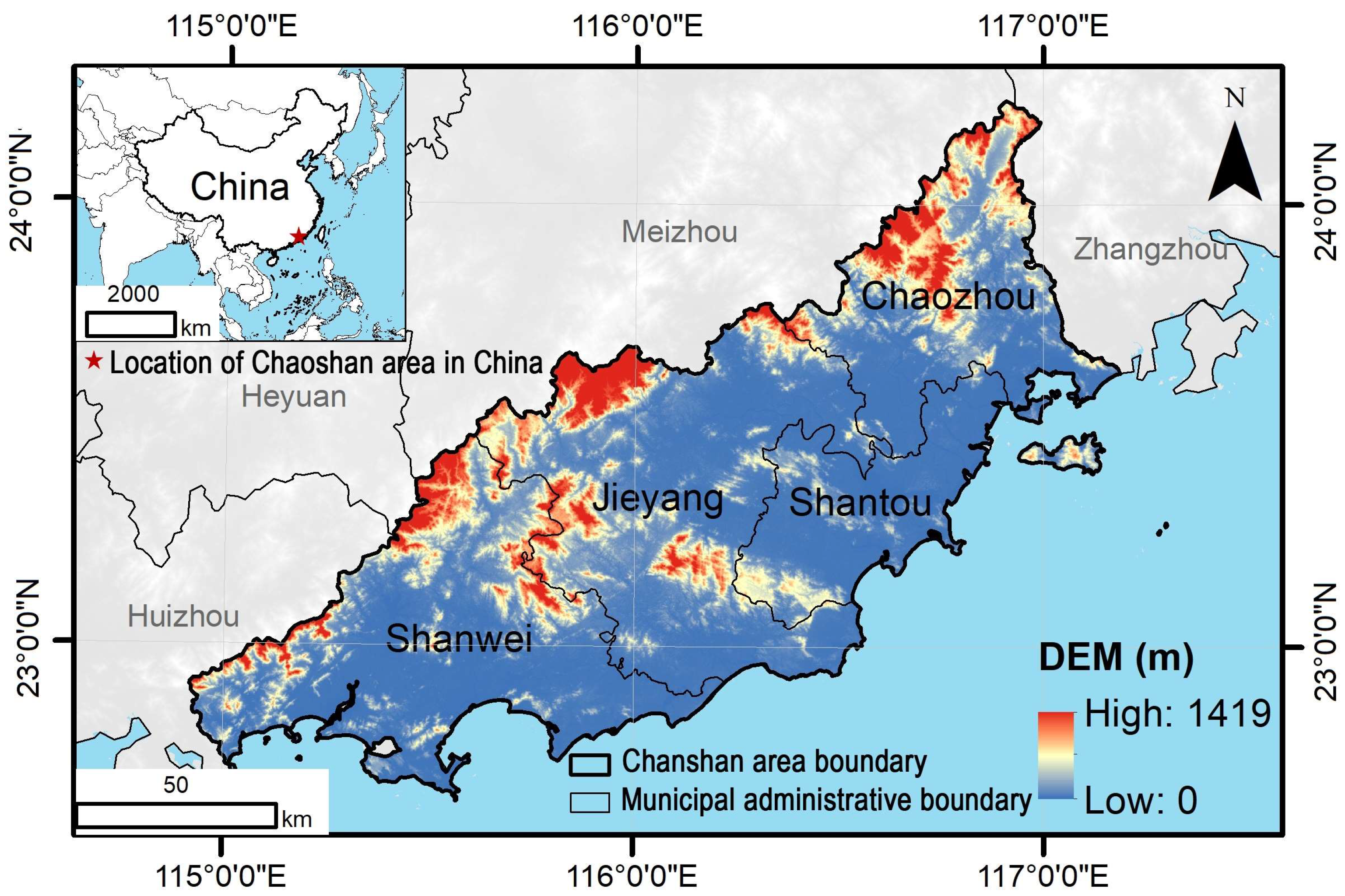
2.1. Study Area

The Chaoshan region (115°30′ E–117°10′ E, 22°30′ N–24°05′ N) is situated in the eastern coastal area of Guangdong Province, China (Figure 1). It encompasses four prefecture-level cities: Shanwei, Jieyang, Shantou, and Chaozhou. The region’s topography is primarily flat, with mountainous and hilly areas in the north and east. The area shows a general slope from the highlands in the northwest to the lowlands in the southeast, spanning a total of 10,346 km2. The region under study is close to the Tropic of Cancer and has a typical subtropical monsoon climate. The Chaoshan region features a warm and humid subtropical climate with relatively stable temperature fluctuations. Annual mean temperatures range between 18 and 22 °C, accompanied by precipitation levels of 1300–1800 mm that exhibit significant seasonal variability, characterized by hot, rainy summers and dry winters. The region hosted a permanent population of 17 million in 2024, representing one of Guangdong Province’s three major Han Chinese dialect-group enclaves renowned for preserving traditional Chinese cultural practices. In 2024, the Chaoshan region recorded a total GDP of 120 billion USD, with a per-capita GDP of 7059 USD. Despite moderate overall economic development, the area exhibits a high urbanization rate, displaying distinct characteristics of pseudo-urbanization. Geographically, the four cities of the Chaoshan region are connected to the economic zone on the western coast of the Taiwan Strait to the east and the Guangdong-Hong kong-Macao Greater Bay Area to the west, thus forming one of the key coastal economic belts within the “One core, one belt, one zone” strategy of Guangdong province. Under the strategic goal of “Reconstructing a New Guangdong”, the ongoing urbanization and further socioeconomic development are driving continuous changes in land use within the region. This situation intensifies the conflict between ecological sustainability and social development. As a result, balancing regional development with ecological protection has become a critical issue that must be addressed in the pursuit of high-quality development within the eastern coastal economic belt of Guangdong.

2.2. Datasets

This study mainly utilizes four types of data: land use, socioeconomic, climate, and environmental data (Table 1). The land use data were sourced from the Resource and Environmental Science Data Center of the Chinese Academy of Sciences (http://www.resdc.cn/, accessed on 19 September 2024), with a resolution of 30 m. In conjunction with previous studies [41,42] and taking into account the specific modeling effects and data availability, this study selected nine driving factors: population density, GDP density, nighttime lights, distance to roads, annual average temperature, annual precipitation, NDVI index, DEM, and slope (Table 1). The agricultural data mainly include the sown area, yield, and unit price of rice, wheat, and soybean crops, with data primarily derived from the statistical yearbooks of Shanwei, Jieyang, Shantou, and Chaozhou cities, as well as the <<China agricultural product price survey yearbook>>. The unit price accounts for inflation and was standardized to 2020 prices. The land use conversion constraint factors determine the cellular conversion rules. All raster data in this study were resampled to a 30 m resolution using ArcGIS, and the spatial coordinate system for each dataset was WGS_1984_World_Mercator to ensure compatibility with the PLUS model. The versions of the free software used were as follows: InVEST 3.14.2, PLUS v1.40, and QGIS 3.34.12. Additionally, due to the relative stability of marine environments, this study excluded changes in the marine, with the exception of coastal wetlands.

3. Methods

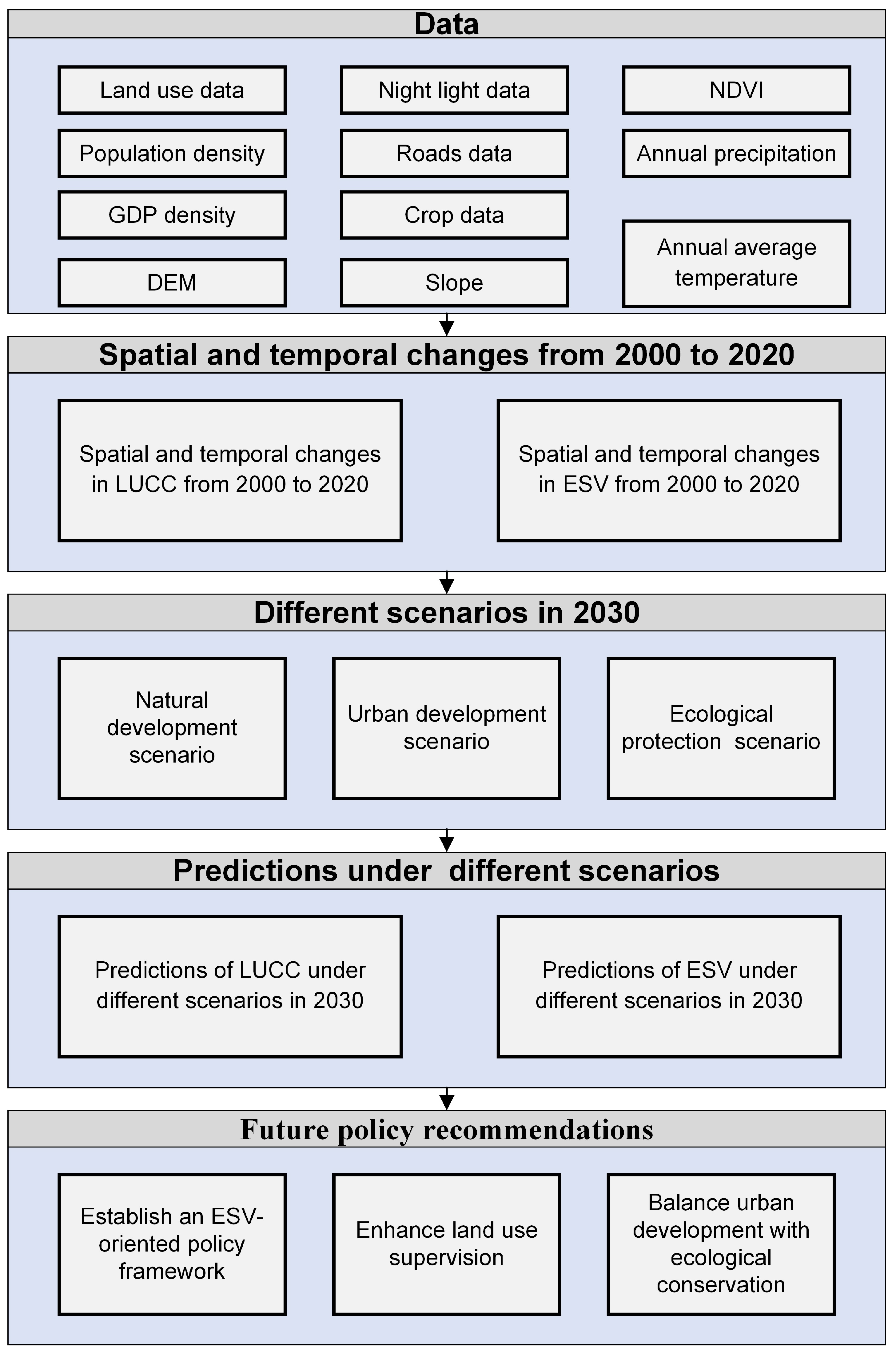
3.1. Research Framework

The research framework is shown in Figure 2. First, we utilized multi-source datasets, including land use, nighttime light intensity, population density, and GDP density. Secondly, we identified the spatiotemporal characteristics of LUCC and ESV changes from 2000 to 2020. Thirdly, we projected LUCC and ESV for 2030 under the natural development (ND), urban development (UD), and ecological protection (EP) scenarios. Finally, we provided support for future policymaking. The core of this process lies in integrating diverse datasets to predict potential future land use patterns and ESV changes while proposing policy recommendations.

3.2. PLUS Model

The PLUS model combines the Land Expansion Analysis Strategy (LEAS) with a cellular automata model utilizing multi-class random patch seeds (CARS) [35]. On the one hand, the driving factors influencing land use changes can be more effectively analyzed by the LEAS module. The key features of the LEAS module include: (1) focusing on change areas to reduce redundant analysis; (2) utilizing random forest to handle complex relationships; (3) applying class-specific modeling to improve accuracy; and (4) incorporating temporal specificity to enhance the time relevance of driving factors. On the other hand, the CARS model incorporates a stochastic seed generation mechanism and a threshold reduction mechanism, which enhances the reliability of the final prediction results. This module primarily achieves a more realistic simulation of complex human–environment systems through physical mechanism-driven processes (probability constraints) and stochastic processes (Monte Carlo simulations). Larger values of the neighborhood factor indicate that the land type is more capable of expanding on its own and less capable of being transformed into other land types; conversely, lower values suggest a higher likelihood of conversion to other land types and greater susceptibility to occupation by other land types. Based on relevant studies [43], the domain weight values that achieved high simulation accuracy in the PLUS software were obtained through continuous debugging and validation, as shown in Table 2.
This study evaluates the accuracy of the PLUS model using the Kappa index and the Figure of Merit (FOM) index. The calculation formulas are as follows:
K a p p a = p 0   p i 1   p i
F O M = B A + B + C + D
where the Kappa index quantifies model accuracy. pi reflects the percentage of accurate predictions within the simulation results, while P0 indicates the proportion of the model’s predictions that align with the actual data. The FOM index is another measure of accuracy, where A refers to areas where LUCC happened, but the model predicted no change. B represents regions where the model’s simulations accurately reflect the actual changes. C indicates areas where the model wrongly predicted land use changes, resulting in errors. Finally, D pertains to regions where no change occurred in reality, but the model incorrectly simulated changes. A higher value of the FOM index indicates better accuracy in the model’s predictions.

3.3. Scenario Simulation Construction

In response to different development needs, in accordance with the “Guangdong province territorial spatial planning (2021–2035)” released by the Guangdong government, and with reference to the framework established by Lou et al. [44], this study defined three land use change scenarios for the Chaoshan region: natural development (ND), urban development (UD) and ecological protection (EP).
ND: This scenario follows the existing urbanization development model and land use conversion rates without imposing restrictions on land use type conversion.
UD: Considering the further advancement of urban development in the study area, the probability of farmland, forest, grassland, and unused land being converted into construction land increases by 20%, while the probability of construction land being converted into forest, grassland, and unused land decreases by 30%.
EP: The probability of conversion of farmland, forest, grassland, and unused land to construction land was reduced by 30%, whereas the probability of conversion of construction land to forest, grassland, and unused land was increased by 20%.

3.4. ESV Assessment

Table 3 is based on the unit area ESV equivalence table established by Xie et al. [6], with parameter settings referenced from Yao et al. [45]. Finally, the calculations were derived using the standard unit value data of the Chaoshan region. Considering the ecological characteristics of the coastal region of eastern Guangdong, the land types were categorized into six primary classes. Unused land was considered desert, while the average values of water systems and wetlands signified water. Other land types were represented using the average values of secondary classifications. In conjunction with the perspective proposed by Costanza et al. [33], which suggests that construction land lacks ecological service functions, the ESV of construction land was set to zero, except that the coefficient of cultural service value was set to 0.163. Using the yields and average prices of major food crops in the Chanshan area for the years 2000, 2010, and 2020 as a baseline, a standard unit of the ESV in the Chanshan area was calculated to be 338.01 USD·hm2·a−1 [46]. This enables the calculation of the ESV per unit area (Table 3), ultimately resulting in the estimation of the multi-period ESV [39]. The calculation process was outlined as follows:
E S V = i = 1 n A i × V C i
V C i = j = 1 k E C j × E a
ESV is the ecosystem service value (USD·a−1); i denotes the land use type; j represents the type of ecosystem service; k indicates the total number of ecosystem service types. VCi refers to the unit area ecosystem service value (USD·hm2·a−1) for land use type i. Ai signifies the area (hm2) dedicated to land use type i. ECj is the equivalence value of the j-th ecosystem service type specific to a given land use type. Finally, Ea represents the value (USD·hm2·a−1) of one standard unit of ecosystem services.

3.5. Sensitivity Analysis

This study uses the Coefficient of Sensitivity (CS) to conduct a sensitivity analysis of the ESV. The principle involves estimating the percentage change in the total ESV and the corresponding sensitivity coefficient obtained by adjusting the service value coefficient by 50%. The calculation formula is as follows:
C S = ( E S V E S V a ) / E S V a V C j V C a / V C a
CS is the sensitivity index; ESV and ESVa represent the initial and adjusted values of ecosystem service value, respectively; VCj and VCa represent the initial and adjusted ecosystem service value coefficients. If | C S | < 1, it indicates that the ecosystem service value (ESV) is less sensitive to changes in the ecosystem service value coefficient (VC), suggesting higher accuracy and reliability. The findings from Table 4 indicate that the results have high reliability ( | C S | < 0.2).

4. Results

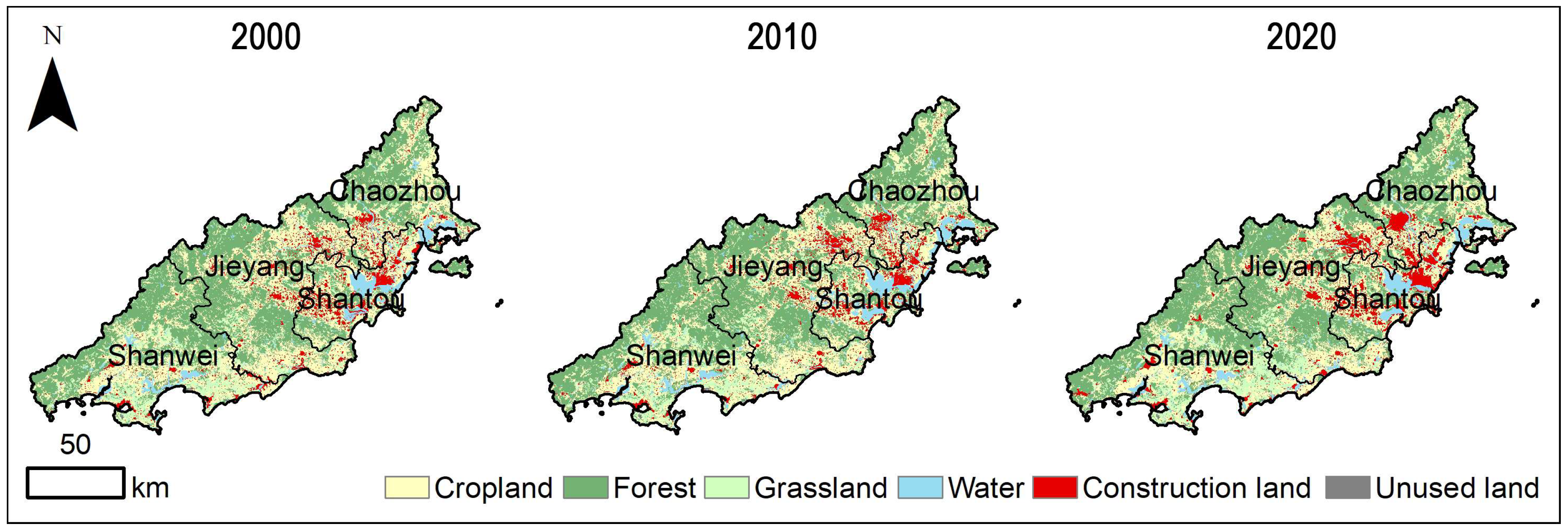
4.1. Spatial and Temporal Changes in LUCC

In this study, the accuracy of the PLUS model’s simulation results was validated by calculating the Kappa and FOM coefficients [47]. The computed values were Kappa = 0.874 (0.874197) and FOM = 0.221 (0.220953), indicating a high level of agreement between the model’s predictions and the actual land use data. The total area of the Chaoshan region, Guangdong Province, was recorded as 1,535,618 hm2, comprising predominantly forest land, cropland, and grassland. In 2000, 2010, and 2020, these three land types collectively constituted 86.87%, 85.66%, and 84.69% of the study region’s total area, respectively (Table 5). Overall, the area of cropland and unused land has decreased, while the area of other land types has increased. From 2000 to 2020, the area of cropland sharply declined, with a total reduction of 52,147 hm2, approximately 3.40% of the total area. Forest land area demonstrated an initial increasing trend, which was subsequently followed by a decrease, resulting in a marginal net increase since 2020. The grassland area initially declined but then increased, rising from 11.38% to 12.22% since 2020. This represents a total increase of 12,837 hm2, accounting for approximately 0.84% of the total area. Water, construction land, and unused land were identified as the least dominant land use categories in the Chaoshan region. Collectively, these three land use categories represented only 13.17%, 14.34%, and 15.31% of the total regional area in 2000, 2010, and 2020, respectively. From 2000 to 2020, the area of construction land expanded significantly by 26,412 hm2, reflecting a 25% increase, thereby representing one of the most dynamically changing land use categories. As illustrated in Figure 3, the expansion is primarily concentrated in the urban areas of Shantou, Jieyang, and Chaozhou, highlighting the pronounced growth of construction land in these cities over the past two decades. The area of water initially increased and then decreased, with a total growth of 7640 hm2. The area of unused land, being relatively small, decreased by 672 hm2. Therefore, the most prominent features of LUCC in the Chaoshan region from 2000 to 2020 were the significant reduction in cropland and the highest growth rate of construction land, with expansion primarily concentrated in Shantou, Jieyang, and Chaozhou.

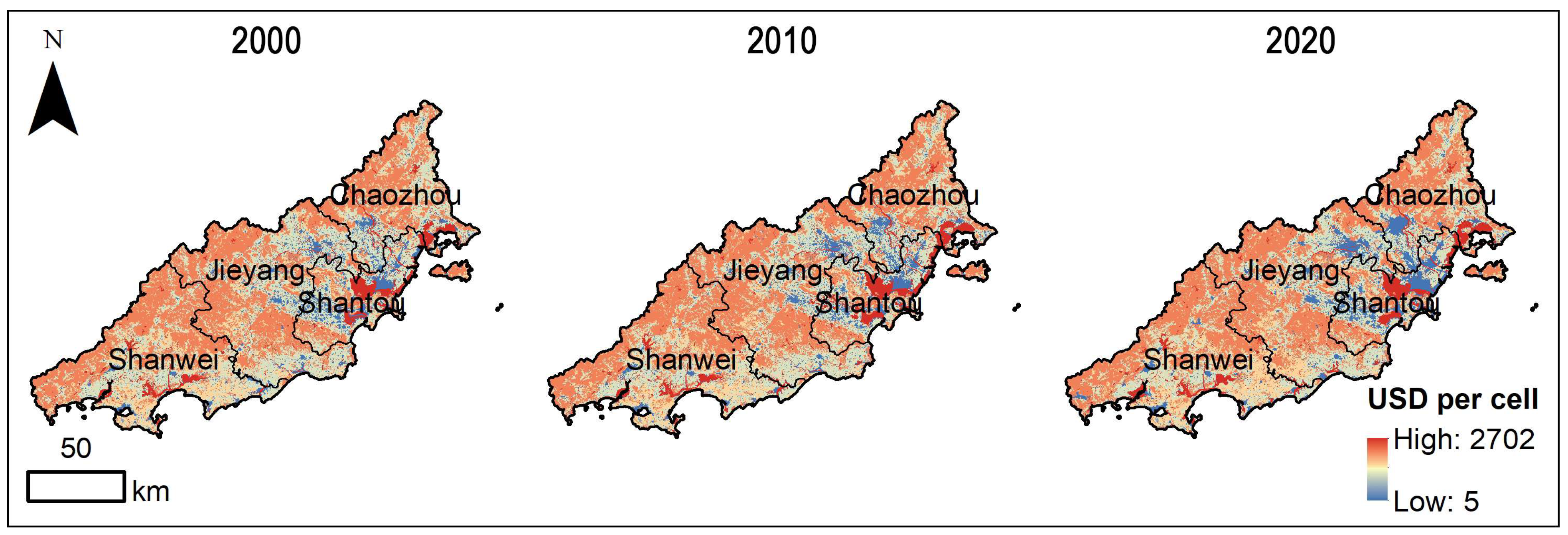
4.2. Spatial and Temporal Changes in ESV

The ESV for the entire study area was 8.49 × 10⁹, 8.91 × 10¹⁰, and 8.74 × 10⁹ USD in 2000, 2010, and 2020, respectively. The total change showed an initial increase of approximately 4.95% during the first decade, followed by a decline of around 1.91% in the next decade, ultimately resulting in an overall increase of 2.94% (0.25 × 10⁹) over the 20 years (Table 6). Low-ESV regions were primarily concentrated at the convergence of Shantou, Jieyang, and Chaozhou. By analyzing the ESV of different cities, it was found that the ranking of the total ESV of each region in different years was consistent: Shanwei > Jieyang > Chaozhou > Shantou (Figure 4). However, total ESV trends varied across cities from 2000 to 2020. The ESV of Shantou initially increased by 15.26% from 2000 to 2010 but declined by 16.67% from 2010 to 2020. Shantou’s total ESV declined by 6.23×10⁷ USD over 20 years, equivalent to a 4.10% decrease. The other three cities experienced an increase in total ESV during the same period, with incremental values of 0.15 × 10⁹, 0.06 × 10⁹, and 0.10 × 10⁹ USD for Shanwei, Chaozhou and Jieyang, respectively. None of these three cities experienced an ESV increase exceeding 6%, reflecting a general trend of slow growth over the 20-year period. Shantou was the only city among the four to experience a decrease in the total ESV.

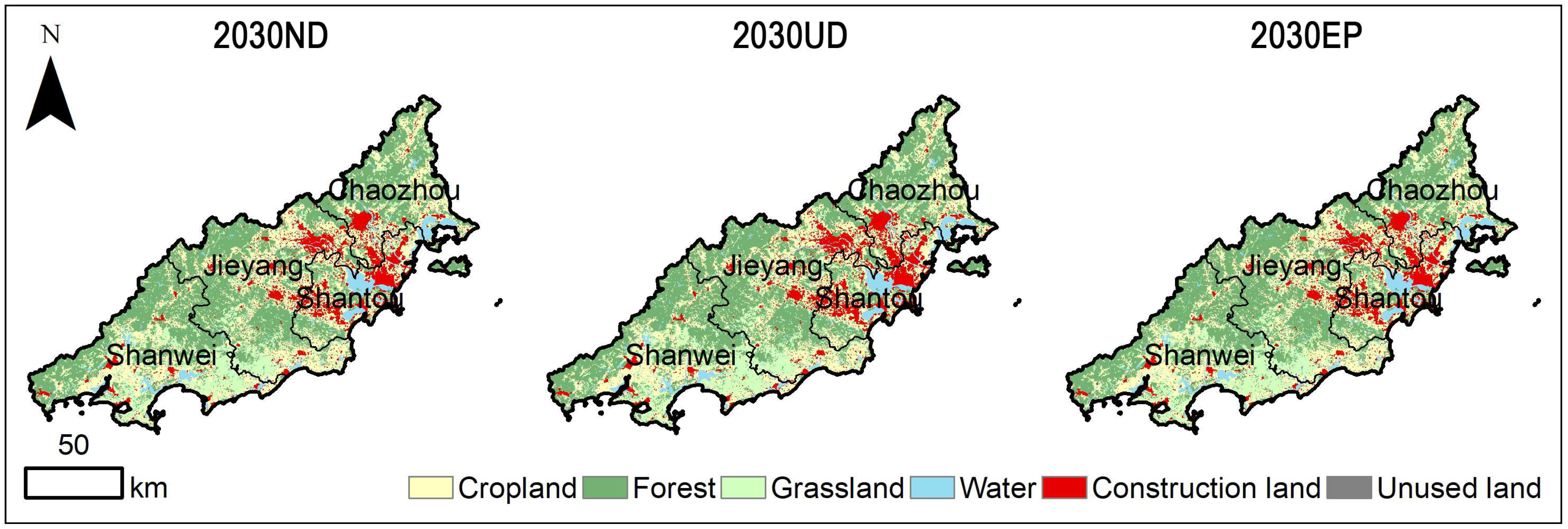
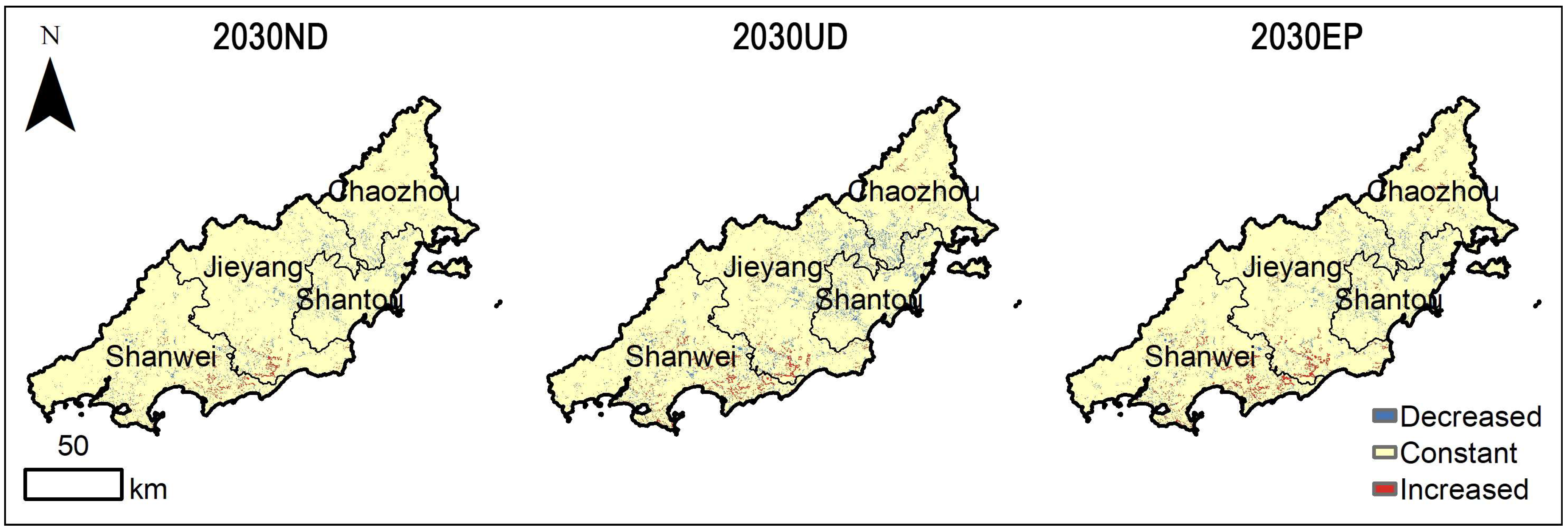
4.3. LUCC Predictions in Different Scenarios

The PLUS model was employed, incorporating three scenario settings—ND, UD, and EP—to simulate land use changes in the Chaoshan region by 2030 (Figure 5 and Table 7). According to the simulation results, compared to 2020, land use types under the different scenarios remain stable, with forest land, cropland, and grassland still being the dominant types. The land types that have undergone area changes primarily include cultivated land, grassland, construction land, and water, with the change in cultivated land area being particularly significant. Under the ND scenario for 2030, grassland and construction land are projected to increase significantly compared to 2020, whereas the areas of other land types are expected to decline. Construction land is projected to grow by 12.20%, adding 16,058 hm2, while grassland is expected to increase by 10.06%, contributing an additional 18,872 hm2. Conversely, cultivated land, forest land, and water are projected to decrease by 27,245 hm2, 2185 hm2, and 5059 hm2, respectively, corresponding to declines of 5.92%, 0.33%, and 5.05%. Under the UD scenario for 2030, grassland and construction land are also expected to increase substantially, adding 34,266 hm2 and 32,045 hm2, respectively, which correspond to growth rates of 18.30% and 24.30%. However, all other land types are projected to decline, with cropland experiencing the most significant reduction, decreasing by 52,750 hm2 (11.46%). In the 2030 EP scenario, grassland and construction land continue to increase, adding 36,819 hm2 and 17,638 hm2, corresponding to growth rates of 19.62% and 13.40%, respectively. Cropland and water are projected to decline by 43,523 hm2 and 8876 hm2, corresponding to reductions of 9.46% and 8.85%, respectively. In comparison to the UD scenario, the construction land growth rate under the EP scenario is observed to be reduced, suggesting a deceleration in urban expansion.

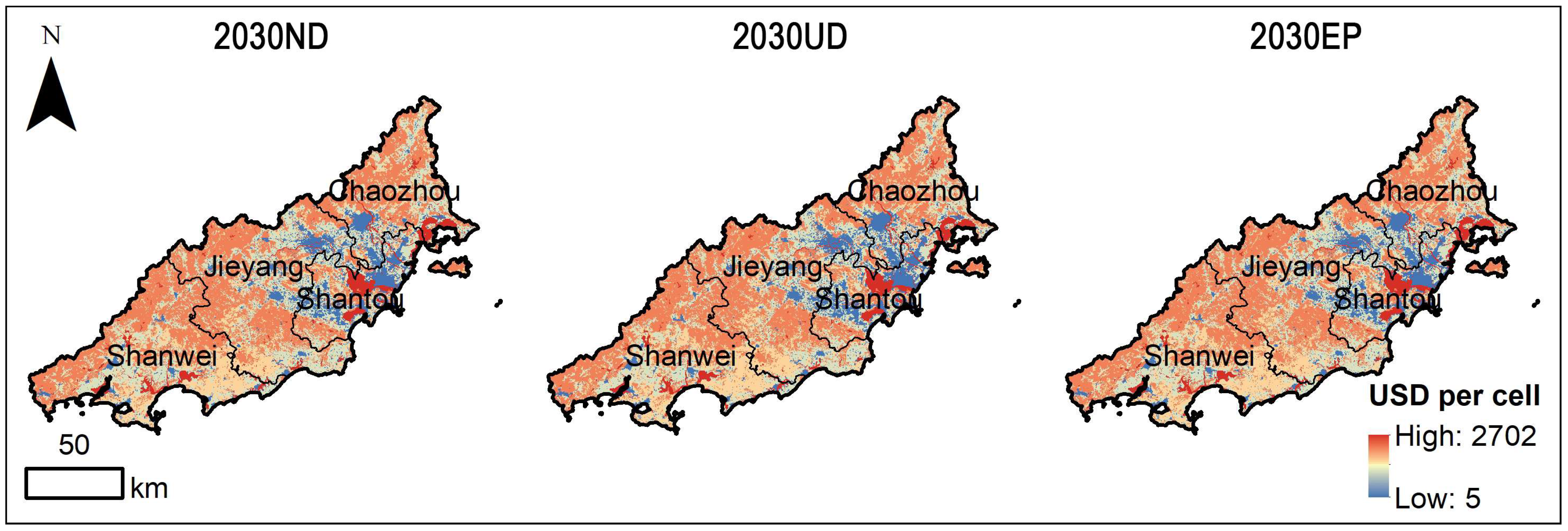
4.4. Predictions of ESV Under Different Scenarios

By 2030, the ESV in the Chaoshan area is expected to reach 8.62 × 10⁹, 8.55 × 10⁹ and 8.58 × 10⁹ USD under the ND, UD, and EP scenarios, respectively (see Figure 6 and Table 8). Compared to 2020, the ESV in these three scenarios decreases by 1.25 × 10⁸, 1.88 × 10⁸, and 1.56 × 10⁸ USD, respectively. Spatially, areas with low ESV are primarily located in the southeast, with some scattered low-value ESV areas found in the southwest (see Figure 6). The variations across all three development scenarios are relatively modest in terms of change, with rates of 1.43%, 2.15%, and 1.78%, respectively. The ESV values in the convergence area of Shantou, Jieyang, and Chaozhou will decrease, while the coastal boundary areas of Shanwei and Jieyang, as well as the northeastern region of Chaozhou, will experience an increase in ESV, as illustrated in Figure 7. In the ND scenario, ESV across the four studied cities exhibits varying degrees of decline compared to 2020, with Chaozhou demonstrating the smallest reduction (1.06 × 10⁷ USD) and Shanwei showing the most substantial decrease (6.24 × 10⁷ USD). Under both UD and EP scenarios, the trends in ESV changes across the four cities align with those observed in the ND scenario. The findings reveal that Shanwei consistently demonstrates the most pronounced ESV decline across all three development scenarios. Notably, under the UD scenario, Shanwei exhibits the sharpest ESV reduction, with a projected decline of 8.33 × 107 USD by 2030.

5. Discussion

5.1. Drivers of Land Use Change

The Sankey diagram in Figure 8 illustrates the temporal changes in land use from 2000 to 2020. The results indicate a significant expansion of construction land areas and a continuous decline in cropland. Meanwhile, grassland, water, and forest areas have gradually increased.
The expansion potential of each land type and the contribution of driving factors are shown in Figure 9 and Table 9. In Figure 9, high potential values indicate a high likelihood of transition to that land type. Specifically, areas with a large potential for the development and utilization of cropland are characterized by dispersion, mainly located in the central region of Shanwei, the northern part of Jieyang, the western part of Shantou, and the northern part of Chaozhou. The development potential for forest land is mostly concentrated in the northern parts of Shanwei, Jieyang, and Chaozhou. The development potential for grassland is mainly concentrated in the southern area along the border of Jieyang and Shanwei. Notably, areas with high potential for urban land development are primarily located in the urban areas at the junction of Shantou, Jieyang, and Chaozhou. The entire Chaoshan region shows high development potential for water areas at the estuaries of the Hanjiang River, Rongjiang River, and Lianjiang River. The potential for developing unused land is relatively low.
In Table 9, the extent to which different land use types were influenced by various driving factors varied significantly. Cropland was primarily influenced by GDP density and the distance to water areas, with contribution rates of 11.55% and 12.49%, respectively. Generally, changes in cropland area are related to economic activities and climate factors in the region [48]. Due to seasonal rainfall variation in the Chaoshan region, precipitation remains low in most seasons except summer, with droughts occurring frequently. Therefore, the expansion of cropland in the region is greatly influenced by the distance to water areas. GDP density is associated with economic activities, suggesting that the expansion of cropland in Chaoshan tends to be near urban areas, facilitating the transport of crops to urban markets. Farmers are more motivated to develop and utilize cropland. The factor contributing the most to the increase in forest land was elevation, reaching 15.59%. This was mainly because forest land in the Chaoshan region is primarily distributed in the higher elevation areas in the northern part of the region. There is almost no forest land in the low-elevation areas of urban and coastal regions. The main factors influencing grassland are climate-related, including annual precipitation, temperature, and the distance to water areas. The region’s primary natural disasters include summer typhoons and autumn-winter droughts, leading to highly uneven rainfall distribution. As a result, significant seasonal differences exist in the extent of water, with notable variations between summer and winter. The increase in construction land was mainly influenced by nighttime light and the distance to water areas, with contribution rates of 14.55% and 16.97%, respectively. This suggests that urban expansion, driven by the needs of economic development, is spreading from the existing urban areas to the surrounding areas. It was also observed that the urban expansion in coastal areas is dependent on water resources [48].

5.2. Response of ESV to LUCC

LUCC represents a primary determinant influencing the study area’s ESV. Figure 2 clearly illustrates the trends in land use change over the 20-year period. The increase in grassland, water bodies, and forested areas can be attributed to China’s grain for green policy, a land management initiative launched in 1999 aimed at converting farmland into forests, grasslands, and lakes. Studies have shown that the first decade of the 21st century witnessed the most significant LUCC changes since the policy’s implementation [49]. The trends observed in our study of the Chaoshan region, particularly the increase in forest and water body areas during the first decade, align with the findings of Han et al. [49]. As shown in Figure 3, construction land in the study area has undergone significant expansion over the past two decades, particularly within the rapidly urbanizing regions of Shantou, Jieyang, and Chaozhou. The urban boundaries of these three cities are progressively converging, reflecting a discernible trend toward urban integration among Shantou, Chaozhou, and Jieyang. The flat terrain of the study area results in a high population concentration around cropland and construction land, driving rapid urban expansion predominantly at the expense of cropland. However, this outcome has not resulted in a continuous decline in ESV; instead, there has been a slight increase in the Chaoshan region’s ESV from 2000 to 2020. As shown in Table 6, a significant contributing factor was the expansion of forest land, grassland, and water. The ESV per unit area for these land types was considerably greater than that of cropland, playing a significant role in the overall ESV calculation (as presented in Table 3). A modest expansion of these three land types has positively impacted ESV, helping offset the negative consequences caused by the large-scale increase in construction land. Focusing solely on the total change in ESV may overlook the significant losses caused by the reduction in cropland area. It is concerning that the cropland area decreased by 52,147 hm2 during the two decades of urbanization. By 2020, the per capita cropland area in the densely populated Chaoshan region had dropped to approximately 113.34 m2 (0.028 acres) per person. This ongoing decline threatens food security and sustainable development. Therefore, future urbanization processes should closely monitor changes in cropland area, strictly maintain cropland balance, and adhere to the red line for cropland protection.
Comparing the predicted ESV in 2020 and 2030, it is clear that the ESV for all three scenarios in 2030 is lower than that of 2020. It implies that as economic growth continues in the Chaoshan region, the demand for urbanized areas is expected to rise over the next decade, which will further erode the overall ESV by progressively consuming other land types. In the 2030 simulated scenarios, the construction land area in the UD scenario surpasses that of the ND and EP scenarios by 15,987 hm2 and 14,407 hm2, respectively. This result indicates that the ESV under the UD scenario is lower than the ESV under the ND and EP scenarios by 6.21 × 10⁷ and 3.21 × 10⁷ USD, respectively. The projected UD pathway is expected to lead to extensive encroachment on diverse ecological land types, which, in turn, will trigger a marked decrease in overall ESV. Furthermore, the 2030 simulation shows that the forest land area under the EP scenario exceeds that in the ND scenario by 893 hm2 and that in the UD scenario by 2459 hm2. Using multi-scenario ESV modeling, Tan et al. [37] and Yang et al. [42] found that the EP scenario resulted in the highest level of forest land protection—in Hanzhong City and the eastern coastal cities of Zhejiang Province, respectively—which aligns with the findings of the current study.
An examination of the spatial distribution of ESV under three different scenarios reveals that the area extending outward from where Shantou, Jieyang, and Chaozhou converge experiences the steepest decline in ESV. The area is recognized as the primary development zone of the Chaoshan Plain, characterized by the highest level of urbanization. As integration and development within the Shantou–Chaozhou–Jieyang metropolitan area accelerate, contiguous urban development and the inevitable expansion of construction land will progressively encroach upon other land types, leading to the loss of diverse ecological land types and a consequent decline in ESV. This is highly likely to have significant impacts on the local ecosystem, such as water quality degradation and biodiversity loss [50]. The Lianjiang River basin, located at the core of the Shantou–Chaozhou–Jieyang metropolitan area, has experienced severe water pollution over the past decade, making it the most heavily polluted river in eastern Guangdong. By 2020, the government had invested over one billion USD in pollution control, with full restoration expected to require at least ten billion USD [51]. Expanding forest cover has been identified as one of the most effective measures to mitigate water pollution [52]. Additionally, land development leads to habitat loss and fragmentation, disrupting migration and breeding pathways for species and negatively impacting biodiversity [53,54]. Overall, the loss of ecological land alters the structure and function of regional ecosystems, ultimately reducing ESV. Therefore, this area may become a region with weakened ecological functions, requiring careful monitoring of dynamic changes in land use patterns and ecological risks caused by urban land expansion in this region.

5.3. Reflections on Future Planning Policies

This study assesses land use types and changes in associated ESV, highlighting the impacts of various land use categories on ecosystems. The findings provide critical support for decision-making regarding optimizing land use structures and sustainable economic, social, and environmental development. Projections suggest a continued decline in ESV in the study area during future development processes. Urban planning must carefully consider the impact of land use changes on ESV, particularly to prevent further declines in ESV in the southeastern part of the study area. It is imperative to integrate ESV into urban planning, identifying the contributions of different land use types to these values, and making rational adjustments to land use structures to enhance ESV in the area [55].
Regarding policy, stringent controls should be implemented on land transformation activities to minimize the encroachment of construction land on arable and grassland, thereby preventing structural imbalances among land types. For example, an ESV-oriented policy framework should be established, which includes developing an eco-compensation mechanism integrated with fiscal incentives. This framework would provide targeted funding allocations to encourage active participation in ecological conservation by local governments and residents. Additionally, ecological product value realization mechanisms should be activated, implementing innovative “ESV + Tourism” models in strategic ecological zones of the Chaoshan region, such as the eastern region of Chaozhou (Raoping county), the northern region (Fenghuang Mountain scenic area), the western region of Jieyang (Jiexi county), and Shanwei. These initiatives would foster eco-tourism and agricultural sightseeing industries, enhancing ecosystem service monetization while maintaining ecological-economic equilibrium [56]. Finally, the four cities in the Chaoshan region should enhance land use supervision and cross-regional coordination mechanisms to ensure the dynamic balance of land types through real-time remote sensing monitoring technology.
In urban planning and development, as this region constitutes the core development zone of the Shantou–Chaozhou–Jieyang metropolitan area, the ESV can be enhanced through the strategic planning of ecological infrastructure in core areas, including urban parks, green spaces, and wetlands. For optimizing the green space and wetland planning in the four cities of the Chaoshan region, the development of ecological corridors should be prioritized. These corridors would connect urban parks, green spaces, and wetlands to form a continuous ecological network, thereby increasing green coverage and enhancing overall ESV. Furthermore, promoting efficient land use is crucial. The concept of a “three-dimensional city” should be encouraged, with a strong focus on the development of public transportation systems. This approach can help alleviate development pressures on ecologically sensitive areas while ensuring sustainable urban development.
The northern and eastern mountainous regions, as well as the southern plains, are primarily composed of ecological protection land and cropland. It is essential to carefully define urban development boundaries, restrict the unchecked expansion of urban spaces, strictly adhere to ecological protection red lines, and prioritize planning strategies that promote positive impacts on ESVs. In high-ESV areas, such as Shanwei, the northern region of Jieyang, and Chaozhou, designated ecological protection zones should be established with strict construction restrictions. Coastal ecological restoration efforts should be implemented to rehabilitate mangroves and other coastal ecosystems, thereby enhancing biodiversity conservation and improving the ESV of coastal regions [57]. More importantly, ecological supervision must be strengthened. Remote sensing and GIS technologies should be employed for real-time monitoring to prevent development from exceeding planned boundaries. Additionally, land use policies should be adjusted to ensure the balance between urban development and ecological conservation.

5.4. Limitations of This Study

This research combines wetlands and water systems into a single category of water for simulation purposes, while also merging urban land and rural settlements into one category of construction land, thus overlooking the developmental patterns that distinguish these land types. This simplification hinders a more detailed analysis of the results. Furthermore, in estimating ESVs, this study relied on the previous literature [6,45,58], setting the coefficient for aesthetic landscape value at 0.163, while assigning a value of 0 to all unit area ESV coefficients for construction land. For some intangible values, such as climate regulation, biodiversity, and cultural values, different researchers may adopt varying methods during the calculation process, which could influence the results. Failure to establish control points to verify land use changes may reduce the accuracy and timeliness of the data. Land use change results from long-term human activities, and the unique traditional culture in the Chaoshan region has a significant impact on the area’s socio-economic development. The exclusion of socio-cultural factors in the land use simulation may lead to inaccuracies in the simulation outcomes [59]. Additionally, the PLUS model, which is driven by historical data to predict future scenarios, may not fully account for various real-world factors, such as policies, economic conditions, and social dynamics. Future research should focus on understanding the internal driving factors of ecosystem services and other service types within urban areas.
As a newly developed tool based on the FLUS model, the applicability of the PLUS model in complex geographical environments (e.g., mountainous areas and wetlands) still requires further empirical validation. According to the study by Li et al. [60], the PLUS model tended to exhibit prediction biases in land types that were heavily influenced by human activities, such as urban areas, bare land, and farmland. Additionally, parameter adjustment and rule setting in the model are relatively complex. The land expansion rules, neighborhood weights, and transition matrix must be determined through historical data mining and manual intervention, making the model highly sensitive to parameter settings. This adjustment process can be time-consuming and demands substantial expertise. Furthermore, the cellular automaton (CA)-based simulation mechanism is sensitive to initial conditions and neighborhood effects, which may result in localized instabilities in simulation outcomes.

6. Conclusions

This research conducts a quantitative assessment of land use transformations and the spatiotemporal dynamics of ESV in the Chaoshan region, utilizing land use data from 2000, 2010, and 2020. The PLUS model was applied to simulate future land use and ESV variations under multiple scenarios for 2030, enabling an evaluation of how these projected changes influence ESV across the three scenarios. The primary conclusions are as follows:
(1)
Between 2000 and 2020, the cropland area in the Chaoshan region decreased significantly by 52,147 hm2. By 2020, the per capita cultivated land area was approximately 113.34 m2 (0.028 acres). Over the past two decades, construction land has continuously expanded, increasing by 26,412 hm2, with the growth concentrated in Shantou, Jieyang, and Chaozhou, reflecting a clear trend of urban integration among these cities. The increase in construction land was mainly influenced by nighttime light and the distance to water areas, with contribution rates of 14.55% and 16.97%. This indicates that urban sprawl is extending from existing urban areas to surrounding regions and is influenced by the presence of water. By 2030, both grassland and construction land areas are projected to increase by more than 10%. However, under the EP scenario, the growth rate of construction land is expected to decline, suggesting a slowdown in urban expansion.
(2)
Between 2000 and 2020, the total ESV in the Chaoshan region exhibited a slow upward trend, with Shantou being the only city experiencing a decline. The areas with low ESV values were primarily located in the southeastern part of the Chaoshan region. By 2030, as urban integration among Shantou, Chaozhou, and Jieyang progresses, the ESV in this region is expected to continue declining.
(3)
The slight increase in grassland, forest, and water may partially offset the negative impact of the significant expansion of construction land. Therefore, focusing solely on changes in total ESV may overlook the severe consequences of cropland loss. The inevitable urban integration of Shantou, Chaozhou, and Jieyang will continue to drive the expansion of construction land at the expense of other land types, potentially turning the region into an ecologically vulnerable area. Close monitoring of the dynamic changes in land use patterns and the ecological risks associated with urban land expansion in this region is crucial.

Supplementary Materials

The following are available online at https://www.mdpi.com/article/10.3390/ijgi14040160/s1, Figure S1: The raster map of driving factors of land use change.

Author Contributions

Conceptualization, Zili Xiong and Song Yao; data curation, Song Yao; formal analysis, Zili Xiong and Liang Yu; funding acquisition, Zili Xiong and Hongmei Liu; investigation, Liang Yu and Zili Xiong; methodology, Song Yao and Zili Xiong; project administration, Song Yao and Zili Xiong; software, Song Yao; supervision, Song Yao and Zili Xiong; writing—original draft, Zili Xiong and Liang Yu; writing—review and editing, Song Yao and Zili Xiong. All authors have read and agreed to the published version of the manuscript.

Funding

This research was funded by the Ph.D. Initiation Project of HanShan Normal University, grant number: QD2024105; and the Science and Technology Planning Project of Guangdong Province, China, grant number: 2023B1212060048.

Data Availability Statement

All the data used in this study appear in Section 2.2 of this article.

Acknowledgments

We are thankful for all of the helpful comments provided by the reviewers. The authors would like to acknowledge the financial support from the Science and Technology Planning Project of Guangdong Province, China, grant number: 2023B1212060048.

Conflicts of Interest

The authors declare no conflict of interest.

References

  1. Ren, Y.M.; Liu, X.P.; Xu, X.C.; Sun, S.S.; Zhao, L.F.; Liang, X.; Zeng, L. Multi-scenario simulation of land use change and its impact on ecosystem services in Beijing-Tianjin-Hebei region based on the FLUS-InVEST Model. Acta Ecol. Sin. 2023, 43, 4473–4487. [Google Scholar] [CrossRef]
  2. Li, R.Q.; Dong, M.; Cui, J.Y.; Zhang, L.L.; Cui, Q.G.; He, W.M. Quantification of the impact of land-use changes on ecosystem services: A case study in Pingbian County, China. Environ. Monit. Assess. 2007, 128, 503–510. [Google Scholar] [CrossRef] [PubMed]
  3. de Groot, R.S.; Alkemade, R.; Braat, L.; Hein, L.; Willemen, L. Challenges in integrating the concept of ecosystem services and values in landscape planning, management and decision making. Ecol. Complex. 2010, 7, 260–272. [Google Scholar] [CrossRef]
  4. Haines-Young, R.; Potschin, M.; Kienast, F. Indicators of ecosystem service potential at European scales: Mapping marginal changes and trade-offs. Ecol. Indic. 2012, 21, 39–53. [Google Scholar] [CrossRef]
  5. Lin, Z.; Peng, S. Comparison of multimodel simulations of land use and land cover change considering integrated constraints—A case study of the Fuxian Lake basin. Ecol. Indic. 2022, 142, 109254. [Google Scholar] [CrossRef]
  6. Xie, G.D.; Zhang, C.X.; Zhang, L.M.; Chen, W.H.; Li, S.M. Improvement of the evaluation method for ecosystem service value based on per unit area. J. Nat. Resour. 2015, 30, 1243–1254. [Google Scholar] [CrossRef]
  7. Fu, B.J.; Zhang, L.W. Land-use change and ecosystem services: Concepts, methods and progress. Prog. Geogr. Sci. 2014, 33, 441–446. [Google Scholar] [CrossRef]
  8. Li, W.H. Valuation of Ecosystem Services: Theories, Methods and Applications; China Renmin University Press: Beijing, China, 2008; ISBN 978-7-300-09783-1. [Google Scholar]
  9. Lamarque, P.; Quétier, F.; Lavorel, S. The diversity of the ecosystem services concept and its implications for their assessment and management. C. R. Biol. 2011, 334, 441–449. [Google Scholar] [CrossRef]
  10. Fu, B.J. Ecosystem Service and Ecological Security; Higher Education Press: Beijing, China, 2013. [Google Scholar]
  11. Zhang, Z.; Wu, C.F.; Tan, R. Application of ecosystem service value in land use change research: Bottlenecks and prospects. Chin. J. Appl. Ecol. 2013, 24, 556–562. [Google Scholar] [CrossRef]
  12. Liu, G.L.; Zhang, L.C.; Zhang, Q. Spatial and temporal dynamics of land use and its influence on ecosystem service value in Yangtze River Delta. Acta Ecol. Sin. 2014, 34, 3311–3319. [Google Scholar] [CrossRef]
  13. Liu, Y.B.; Hou, X.Y.; Li, X.W. Assessing and predicting changes in ecosystem service values based on landuse/cover change in the Bohai rim coastal zone. Ecol. Indic. 2020, 111, 106004. [Google Scholar] [CrossRef]
  14. Zhang, Y.S.; Wu, D.T.; Lyu, Y.X. A review on the impact of land use/land cover change on ecosystem services from a spatial scale perspective. J. Nat. Resour. 2020, 35, 1172–1189. [Google Scholar] [CrossRef]
  15. Clerici, N.; Cote-Navarro, F.; Escobedo, F.J.; Rubiano, K.; Villegas, J.C. Spatio-temporal and cumulative effects of land use-land cover and climate change on two ecosystem services in the colombian andes. Sci. Total Environ. 2019, 685, 1181–1192. [Google Scholar] [CrossRef] [PubMed]
  16. Gomes, E.; Inácio, M.; Bogdzevi, K.; Kalinauskas, M.; Karnauskait, D.; Pereira, P. Future land-use changes and its impacts on terrestrial ecosystem services: A review. Sci. Total Environ. 2021, 781, 146716. [Google Scholar] [CrossRef] [PubMed]
  17. Cao, Y.; Kong, L.; Zhang, L.; Ouyang, Z. The balance between economic development and ecosystem service value in the process of land urbanization: A case study of China’s land urbanization from 2000 to 2015. Land Use Policy 2021, 108, 105536. [Google Scholar] [CrossRef]
  18. Richards, D.R.; Belcher, R.N.; Carrasco, L.R.; Edwards, P.J.; Fatichi, S.; Hamel, P.; Masoudi, M.; McDonnell, M.J.; Peleg, N.; Stanley, M.C. Global variation in contributions to human well-being from urban vegetation ecosystem services. One Earth 2022, 5, 522–533. [Google Scholar] [CrossRef]
  19. Jokar Arsanjani, M.; Helbich, M.; Kainz, W. Integration of logistic regression, Markov chain and cellular automata models to simulate urban expansion. Int. J. Appl. Earth Obs. Geoinf. 2013, 21, 265–275. [Google Scholar] [CrossRef]
  20. Liao, G.; He, P.; Gao, X.; Lin, Z.; Huang, C.; Zhou, W.; Deng, O.; Xu, C.; Deng, L. Land use optimization of rural production–living–ecological space at different scales based on the BP-ANN and CLUE-S models. Ecol. Indic. 2022, 137, 6876. [Google Scholar] [CrossRef]
  21. Nasiakou, S.; Vrahnakis, M.; Chouvardas, D.; Mamanis, G.; Kleftoyanni, V. Land use changes for investments in silvoarable agriculture projected by the CLUE-S spatio-temporal model. Land 2022, 11, 598. [Google Scholar] [CrossRef]
  22. Liu, X.; Liang, X.; Li, X.; Xu, X.; Ou, J.; Chen, Y.; Li, S.; Wang, S.; Pei, F. A future land use simulation model (FLUS) for simulating multiple land use scenarios by coupling human and natural effects. Landsc. Urban Plan. 2017, 168, 94–116. [Google Scholar] [CrossRef]
  23. Wang, X.D.; Yao, Y.; Ren, S.L.; Shi, X. A coupled FLUS and markov approach to simulate the spatial pattern of land use in rapidly developing cities. J. Geo-Inf. Sci. 2022, 24, 100–113. [Google Scholar] [CrossRef]
  24. Liu, M.; Xiong, Y.; Zhang, A. Multi-scale telecoupling effects of land use change on ecosystem services in urban agglomerations—A case study in the middle reaches of Yangtze River urban agglomerations. J. Clean. Prod. 2023, 415, 137878. [Google Scholar] [CrossRef]
  25. Lin, Q.; Luo, G.P.; Chen, X. Review of land-use model. Prog. Geogr. 2005, 24, 79–87. [Google Scholar]
  26. Zhang, Y.M.; Zhao, S.D.; Verburg, P.H. CLUE-S CLUE-S and its application for simulating temporal and spatial change of land use in Naiman Banner. J. Nat. Resour. 2003, 18, 310–318. [Google Scholar]
  27. Ren, J. Scenario Simulation of Regional Land Use Change Based on CLUE-S Model—A Case Study of Jizhou District. Master’s Thesis, Tianjin University of Technology, Tianjin, China, 2021. [Google Scholar] [CrossRef]
  28. Xie, H.L.; Liu, L.M.; Li, B.; Zhang, X. Spatial auto-correlation analysis of multi-scale land- use changes: A case study in Ongniud Banner, Inner Mongolia. Acta Geogr. Sin. 2006, 61, 389–400. [Google Scholar]
  29. Zhang, J.D.; Mei, Z.X.; Lv, J.H.; Chen, J. Simulating multiple land use scenarios based on the FLUS model considering spatial auto-correlation. J. Geo-Inf. Sci. 2020, 22, 531–542. [Google Scholar] [CrossRef]
  30. Tan, X.H.; Feng, W.L.; Xu, W.X.; Li, L.; Niu, X. Application and comparison of FLUS and PLUS model on land use simulation in the Nianchu river basin. Plateau Sci. Res. 2024, 8, 34–45. [Google Scholar] [CrossRef]
  31. Liu, F.L.; Yang, R.Y. Evolution of land use patterns in national central cities and its impact on ecosystem service values: A case study of Wuhan city. Int. Soil Water Conserv. Res. 2021, 28, 177–183. [Google Scholar] [CrossRef]
  32. Yang, G.Z.; Lyu, K.; Li, F. Spatial and temporal correlation analysis of land use change and ecosystem service value in Nanchang City based on grid scale. China Land Sci. 2022, 36, 121–130. [Google Scholar]
  33. Costanza, R.; d’Arge, R.; De Groot, R.; Farber, S.; Grasso, M.; Hannon, B.; Limburg, K.; Naeem, S.; O’Neill, R.V.; Paruelo, J.; et al. The value of the world’s ecosystem services and natural capital. Nature 1997, 387, 253–260. [Google Scholar] [CrossRef]
  34. Kindu, M.; Schneider, T.; Teketay, D. Changes of ecosystem service values in response to land use/land cover dynamics in Munessa-Shashemene landscape of the Ethiopian highlands. Sci. Total Environ. 2016, 547, 137–147. [Google Scholar] [CrossRef]
  35. Liang, X.; Guan, Q.F.; Clarke, K.C.; Liu, S.; Wang, B.; Yao, Y. Understanding the drivers of sustainable land expansion using a patchgenerating land use simulation (PLUS) model: A case study in Wuhan, China. Comput. Environ. Urban Syst. 2021, 85, 101569. [Google Scholar] [CrossRef]
  36. Gao, L.N.; Tao, F.; Liu, R.R.; Wang, Z.; Leng, H.; Zhou, T. Multi-scenario simulation and ecological risk analysis of land use based on the PLUS model: A case study of Nanjing. Sustain. Cities Soc. 2022, 85, 104055. [Google Scholar] [CrossRef]
  37. Tan, Z.Z.; Chen, Y.Q.; Ding, J.F.; Liu, M.-D.; Wang, H.; Wang, J. Simulation of land use and assessment of ecosystem service value in the eastern coastal cities of Zhejiang Province, China. Chin. J. Appl. Ecol. 2023, 34, 2777–2787. [Google Scholar] [CrossRef]
  38. Guo, R.; Wu, T.; Wu, X.; Luigi, S.; Wang, Y. Simulation of urban land expansion under ecological constraints in Harbin-Changchun urban agglomeration China. Chin. Geogr. Sci. 2022, 32, 438–455. [Google Scholar] [CrossRef]
  39. Gao, X.; Yang, L.; Li, C.; Song, Z.; Wang, J. Land use change and ecosystem service value measurement in Baiyangdian Basin under the simulated multiple scenarios. Acta Ecol. Sin. 2021, 41, 7974–7988. [Google Scholar] [CrossRef]
  40. Cai, S.M.; Wen, Y.Y. Characteristics and driving factors of construction land expansion in Chaoshan Region from 1980 to 2013. Jiangxi Sci. 2022, 1, 40. [Google Scholar]
  41. Li, C.; Gao, B.B.; Wu, Y.M.; Zheng, K.J.; Wu, Y. Dynamic simulation of landscape ecological risk in mountain towns based on PLUS model. J. Zhejiang AF Univ. 2022, 39, 84–94. [Google Scholar] [CrossRef]
  42. Yang, S.; Su, H.; Zhao, G. Multi-scenario simulation of urban ecosystem service value based on PLUS model: A case study of Hanzhong city. J. Arid Land Resour. Environ. 2022, 36, 86–95. [Google Scholar] [CrossRef]
  43. Pu, J.H.; Chen, S.L.; Du, F.Y. Simulation of land use change and response of ecosystem service value of Fuzhou city based on PLUS model. J. Subtrop. Resour. Environ. 2024, 19, 137–146. [Google Scholar] [CrossRef]
  44. Lou, Y.; Yang, D.; Zhang, P.; Zhang, Y.; Song, M.; Huang, Y.; Jing, W. Multi-scenario simulation of land use changes with ecosystem service value in the Yellow river basin. Land 2022, 11, 992. [Google Scholar] [CrossRef]
  45. Yao, S.; Li, Y.; Quan, X.; Xu, J. Applying the driver-pressure-state-impact-response model to ecological restoration: A case study of comprehensive zoning and benefit assessment in Zhejiang Province, China. Glob. Ecol. Conserv. 2024, 55, e03222. [Google Scholar] [CrossRef]
  46. Xie, G.D.; Lu, C.X.; Leng, Y.F.; Zheng, D.U.; Li, S.C. Ecological assets valuation of the Tibetan Plateau. J. Nat. Resour. 2003, 18, 189–196. [Google Scholar] [CrossRef]
  47. Yao, S.; Li, Y.; Jiang, H.; Wang, X.; Ran, Q.; Ding, X.; Wang, H.; Ding, A. Predicting land use changes under shared socioeconomic pathway–representative concentration pathway scenarios to support sustainable planning in high-density urban areas: A case study of Hangzhou, southeastern China. Buildings 2024, 14, 2165. [Google Scholar] [CrossRef]
  48. Li, G.; Sun, S.; Fang, C. The varying driving forces of urban expansion in China: Insights from a spatial -temporal analysis. Landsc. Urban Plan. 2018, 174, 63–77. [Google Scholar] [CrossRef]
  49. Han, Y.H.; Ma, Z.G.; Li, M.X.; Chen, L. Simulation of the Impact of Land Use/Cover Change on Land Surface Process in China from 2001 to 2010. Clim. Environ. Res. 2021, 26, 75–90. [Google Scholar] [CrossRef]
  50. Zeng, J.; Cui, X.; Chen, W.; Yao, X. Impact of urban expansion on the supply-demand balance of ecosystem services: An analysis of prefecture-level cities in China. Environ. Impact Assess. Rev. 2023, 99, 107003. [Google Scholar] [CrossRef]
  51. Guo, J.K.; Zhou, H.; Xia, H.B.; Yuan, D.; Zhang, J.S.; He, Z.H. The process and results for water pollution control in Lianjiang river basin. Water Wastewater Eng. 2021, 47, 57–61. [Google Scholar] [CrossRef]
  52. Shi, X.Y.; Mao, D.H.; Song, K.S.; Xiang, H.; Li, S.; Wang, Z. Effects of landscape changes on water quality: A global meta-analysis. Water Res. 2024, 260, 121946. [Google Scholar] [CrossRef]
  53. Urban, M.C.; Alberti, M.; De Meester, L.; Zhou, Y.; Verrelli, B.C.; Szulkin, M.; Schmidt, C.; Savage, A.M.; Roberts, P.; Rivkin, L.R.; et al. Interactions between climate change and urbanization will shape the future of biodiversity. Nat. Clim. Change 2024, 14, 436–447. [Google Scholar] [CrossRef]
  54. Spotswood, E.N.; Beller, E.E.; Grossinger, R.; Grenier, J.L.; Heller, N.E.; Aronson, M.F.J. The biological deserts fallacy: Cities in their landscapes contribute more than we think to regional biodiversity. BioScience 2021, 71, 148–160. [Google Scholar] [CrossRef] [PubMed]
  55. Lei, J.C.; Wang, S.; Wang, J.M. Effects of land use change on ecosystem services value of Xunwu County. Acta Ecol. Sin. 2019, 39, 3089–3099. [Google Scholar] [CrossRef]
  56. Chen, J.; Guo, Z.; Xu, S.; Law, R.; Liao, C.; He, W.; Zhang, M. A Bibliometric Analysis of Research on Intangible Cultural Heritage Tourism Using CiteSpace: The Perspective of China. Land 2022, 11, 2298. [Google Scholar] [CrossRef]
  57. Veisi Nabikandi, B.; Rastkhadiv, A.; Feizizadeh, B.; Gharibi, S.; Gomes, E. A scenario-based framework for evaluating the effectiveness of nature-based solutions in enhancing habitat quality. Geo J. 2025, 90, 55. [Google Scholar] [CrossRef]
  58. Yao, S.; Huang, G.; Chen, Z. Evaluation of urban flood adaptability based on the InVEST model and GIS: A case study of New York City, USA. Nat. Hazards 2024, 120, 11063–11082. [Google Scholar] [CrossRef]
  59. Pal, S.; Bauch, C.T.; Anand, M. Coupled social and land use dynamics affect dietary choice and agricultural land use extent. Commun. Earth Environ. 2021, 2, 204. [Google Scholar] [CrossRef]
  60. Li, Z.; Jiang, W.; Peng, K.; Wang, X.; Deng, Y.; Yin, X.; Ling, Z. Comparative analysis of land use change prediction models for land and fine wetland types: Taking the wetland cities Changshu and Haikou as examples. Landsc. Urban Plan. 2024, 243, 104975. [Google Scholar] [CrossRef]
Figure 1. Geographic positioning and digital elevation model (DEM) of the Chaoshan region in southeastern China.
Ijgi 14 00160 g001
Figure 2. The research framework.
Ijgi 14 00160 g002
Figure 3. Land use distribution from 2000 to 2020.
Ijgi 14 00160 g003
Figure 4. ESV from 2000 to 2020.
Ijgi 14 00160 g004
Figure 5. Land use distribution in 2030.
Ijgi 14 00160 g005
Figure 6. ESV in 2030.
Ijgi 14 00160 g006
Figure 7. ESV change in from 2020 to 2030.
Ijgi 14 00160 g007
Figure 8. Transfer processes of various land use types in the Chaoshan area from 2000 to 2020. Note: The column length represents the area of different land use types, while the width of the connections indicates the area converted to other land use types.
Ijgi 14 00160 g008
Figure 9. Development potential of each land use. Letters a–f are subfigures labels: (a) Cultivated land; (b) Forest; (c) Grassland; (d) Water; (e) Construction land; (f) Unused land.
Ijgi 14 00160 g009
Table 1. Information and origins of data.
DataYearResolutionSource
Land use data2000–202030 mhttp://www.resdc.cn/
accessed on 19 September 2024
Population density20201 kmhttps://hub.worldpop.org/
accessed on 19 September 2024
GDP density20201 kmhttp://www.resdc.cn/
accessed on 19 September 2024
Night light 2020500 mhttps://www.geodata.cn
accessed on 19 September 2024
Roads2020-https://www.openstreetmap.org
accessed on 19 September 2024
Crops2020-https://www.stats.gov.cn
accessed on 19 September 2024
Annual average temperature20201 kmhttp://www.resdc.cn/
accessed on 19 September 2024
Annual precipitation20201 kmhttp://www.resdc.cn/
accessed on 19 September 2024
NDVI202030 mhttp://www.nesdc.org.cn/
accessed on 19 September 2024
DEM202030 mhttps://www.gscloud.cn/
accessed on 19 September 2024
Slope202030 mRetrieved from DEM
Notes: The raster map of driving factors of land use change was shown in Figure S1.
Table 2. Neighborhood weights.
Cultivated LandForestGrasslandWaterConstruction LandUnused Land
Weight0.70.40.30.20.90.1
Table 3. ES equivalent value per unit area in Chaoshan area (USD/hm2).
First ClassSecond ClassFarmlandForestGrasslandWaterConstruction LandUnused Land
Supply serviceFood production373.5085.3578.87221.400.003.38
Raw material production82.81196.05116.05123.370.0010.14
water supply−441.10101.4064.221838.770.006.76
Conditioning serviceGas regulation300.83644.75407.87451.240.0037.18
Climate regulation157.171929.191078.25995.440.0033.80
Waste treatment45.63565.32356.041546.400.00104.78
Hydrological regulation505.321262.47789.8221,374.060.0070.98
Support Servicessoil conservation175.77785.03496.87547.580.0043.94
Maintaining nutrient cycling52.3960.0038.3142.250.003.38
Maintain biodiversity57.46714.89451.811761.030.0040.56
Cultural servicesProvide landscape aesthetics25.35313.50199.431118.8155.1816.90
Total9209.271335.146657.954077.5330,020.3655.18
Table 4. ESV sensitivities of the different land use types.
Land Use TypesESV (USD)Coefficient of Sensitivity (CS)
200020102020200020102020
Cultivated land VC + 50%8,831,935,8559,244,640,4569,049,879,458−0.0194−0.0179−0.0170
Cultivated land VC − 50%8,147,883,2338,584,050,7758,435,450,8230.02100.01920.0182
Forestland VC + 50%10,643,033,78811,096,687,61610,915,558,708−0.1012−0.0983−0.0995
Forestland VC − 50%6,336,785,3006,732,003,6156,569,771,5730.16990.16210.1654
Grassland VC + 50%8,846,282,8209,251,009,6349,125,196,203−0.0201−0.0182−0.0210
Grassland VC − 50%8,133,536,2688,577,681,5978,360,134,0780.02190.01960.0229
Water VC + 50%9,879,717,18510,518,492,30910,247,131,787−0.0703−0.0763−0.0734
Water VC − 50%7,100,101,9037,310,198,9227,238,198,4940.09790.10970.1039
Construction land VC + 50%8,492,812,4538,917,366,3088,746,296,694−0.0002−0.0002−0.0002
Construction land VC − 50%8,486,277,9918,911,324,9248,739,033,5880.00020.00020.0002
Unused land VC + 50%8,490,629,9358,915,050,1798,746,296,6940.00000.0000−0.0002
Unused land VC − 50%8,489,189,1538,913,641,0528,742,069,7170.00000.00000.0000
Table 5. Land use configuration from 2000 to 2020.
Land Use TypeArea and Proportion200020102020
Cultivated landArea (hm2)512,345494,772460,198
Proportion (%)33.3732.2229.97
ForestArea (hm2)646,783655,559652,721
Proportion (%)42.1242.6942.50
GrasslandArea (hm2)174,799165,131187,629
Proportion (%)11.3810.7512.22
WaterArea (hm2)92,591106,871100,230
Proportion (%)6.036.966.53
Construction landArea (hm2)105,225109,495131,637
Proportion6.857.138.57
Unused landArea (hm2)387537903203
Proportion (%)0.250.250.21
Total landArea (hm2)1,535,6181,535,6181,535,618
Proportion (%)100.00100.00100.00
Table 6. Total ESV from 2000 to 2020 (unit: USD).
Area200020102020
Shantou1,511,702,6451,741,516,7771,449,417,294
Shanwei2,760,993,9632,820,500,9512,912,310,738
Chaozhou1,748,368,8761,805,847,5491,813,347,851
Jieyang2,466,605,1882,544,278,4332,565,461,299
Chaoshan area8,487,670,6728,912,143,7108,740,537,182
Table 7. Land use configuration in 2030.
Land Use TypeArea and Proportion2030 Natural Development Scenario2030 Urban Development Scenario2030 Ecological Conservation Scenario
Cultivated landArea (hm2)432,953407,450416,675
Proportion (%)28.1926.5327.13
ForestArea (hm2)650,536648,969651,427
Proportion (%)42.3642.2642.42
GrasslandArea (hm2)206,501221,895224,448
Proportion (%)13.4514.4514.62
WaterArea (hm2)95,17191,18591,354
Proportion (%)6.205.945.95
Construction landArea (hm2)147,695163,682149,275
Proportion (%)9.6210.669.72
Unused landArea (hm2)276224372439
Proportion (%)0.180.160.16
Total landArea (hm2)1,535,6181,535,6181,535,618
Proportion (%)100.00100.00100.00
Table 8. Total ESV in 2030 (unit: USD).
Area2030 Natural Development Scenario2030 Urban Development Scenario2030 Ecological Conservation Scenario
Shantou1,431,982,3131,418,948,0251,427,752,019
Shanwei2,849,866,8052,829,028,7682,835,342,938
Chaozhou1,802,715,1721,795,285,2091,801,226,039
Jieyang2,530,902,9182,509,176,8822,520,264,965
Chaoshan area8,615,467,2088,552,438,8848,584,585,961
Table 9. Contributions of driving factors to the expansion of each land use type.
X1X2X3X4X5X6X7X8X9X10X11X12
Cultivated land6.54%11.55%7.52%7.04%7.39%6.12%9.58%9.67%8.35%4.75%9.00%12.49%
Forest15.59%5.69%6.78%7.27%9.04%6.25%5.59%10.67%7.82%5.23%10.25%9.82%
Grassland4.90%11.87%8.60%4.53%5.26%3.38%9.87%13.60%9.08%5.09%11.93%11.89%
Water0.42%3.93%1.38%3.16%1.02%0.21%8.90%0.69%1.87%0.57%0.61%77.24%
Construction land6.10%7.96%5.59%5.62%12.88%14.55%4.05%9.25%6.49%3.38%7.16%16.97%
Unused land16.88%10.13%16.40%5.54%1.48%3.80%2.18%21.20%5.97%1.22%13.69%1.51%
Note: X1 = DEM, X2 = GDP density, X3 = distance to highway, X4 = distance to main roads, X5 = NDVI, X6 = night light, X7 = population density, X8 = annual precipitation, X9 = distance to railroads, X10= slope, X11 = temperature, X12 = distance to water.
Disclaimer/Publisher’s Note: The statements, opinions and data contained in all publications are solely those of the individual author(s) and contributor(s) and not of MDPI and/or the editor(s). MDPI and/or the editor(s) disclaim responsibility for any injury to people or property resulting from any ideas, methods, instructions or products referred to in the content.

