


Understanding the Carbon Footprint of Tile Transfer for Web Maps

 , , and
Abstract
1. Introduction
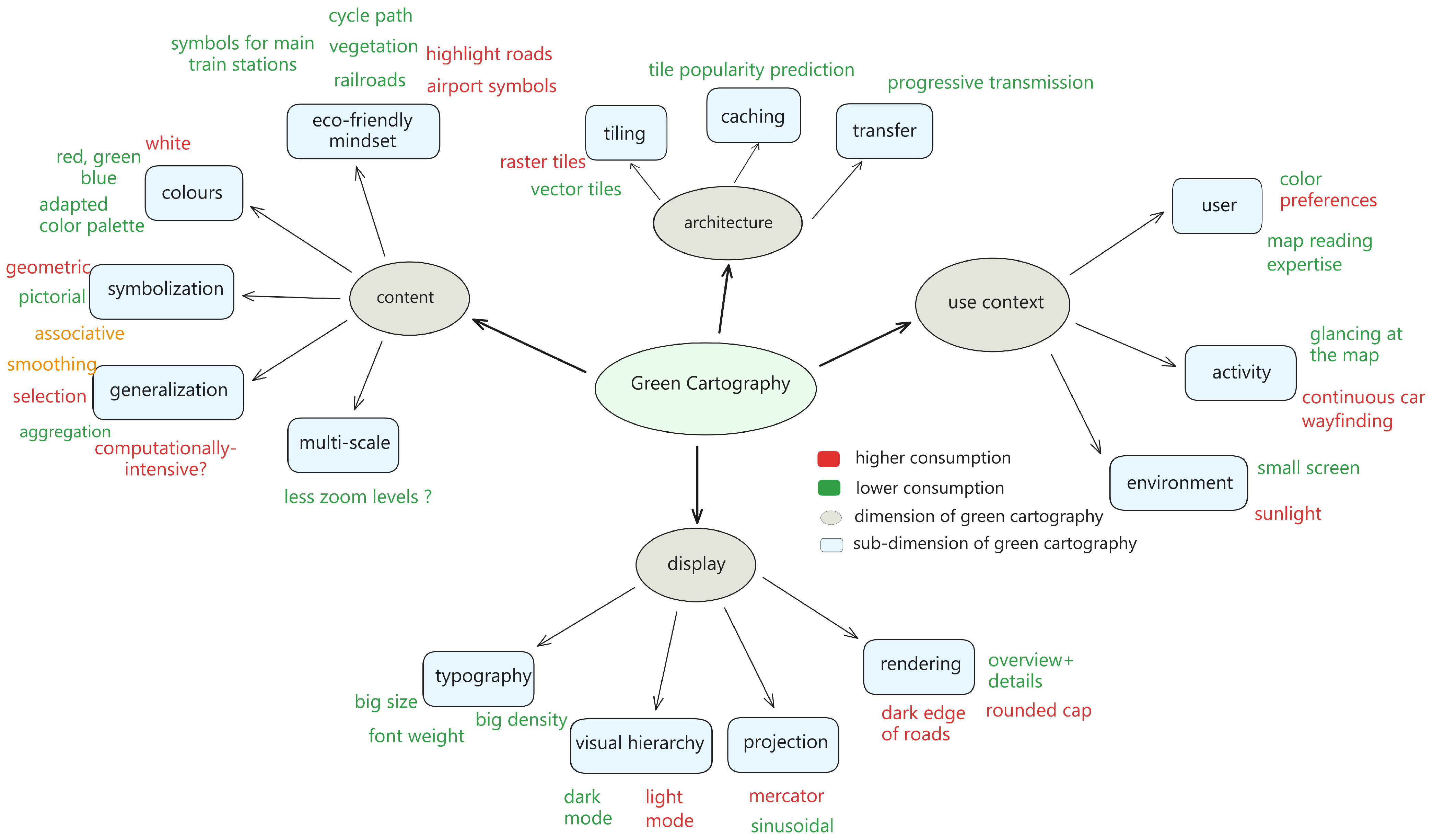
2. Green Cartography and Green Computing
3. How Many and Which Tiles Do Map Users Use?
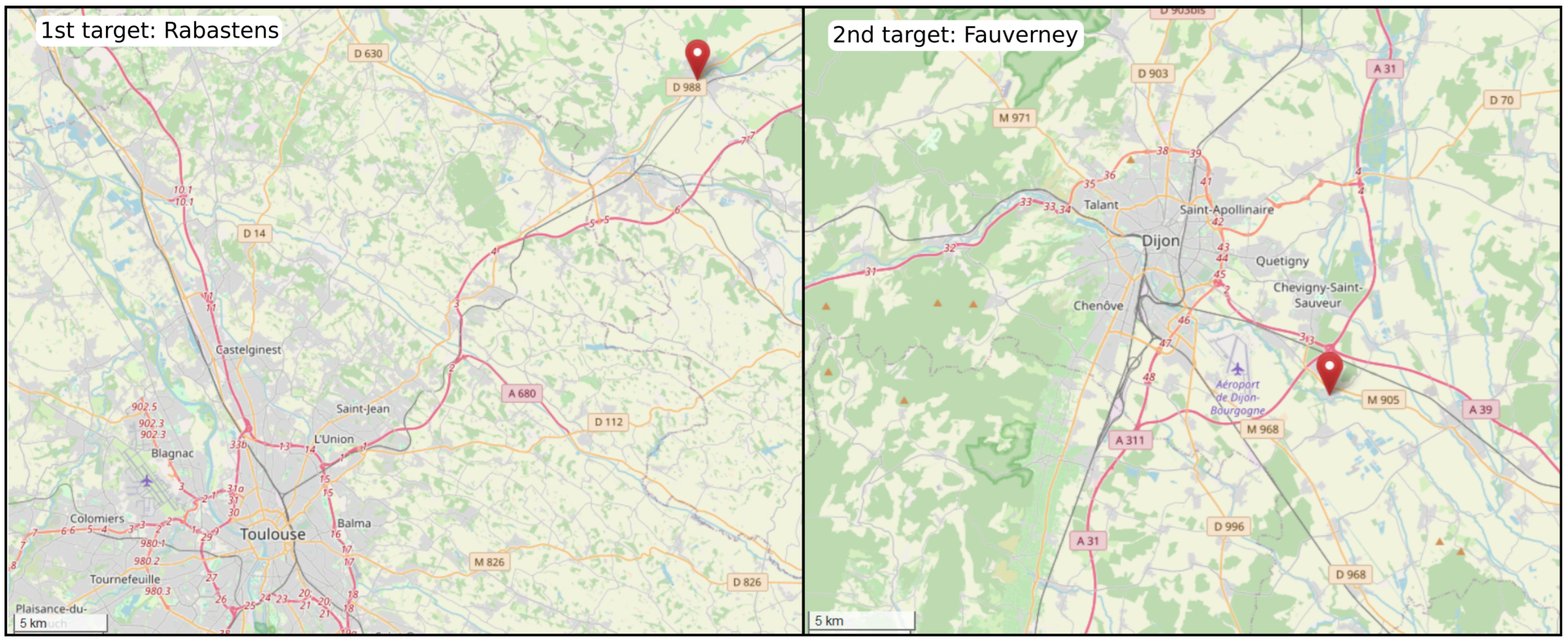
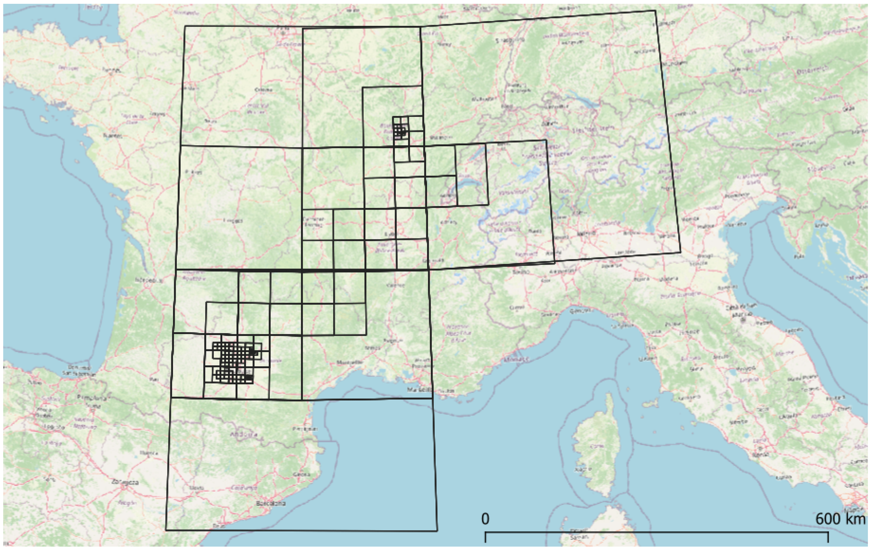
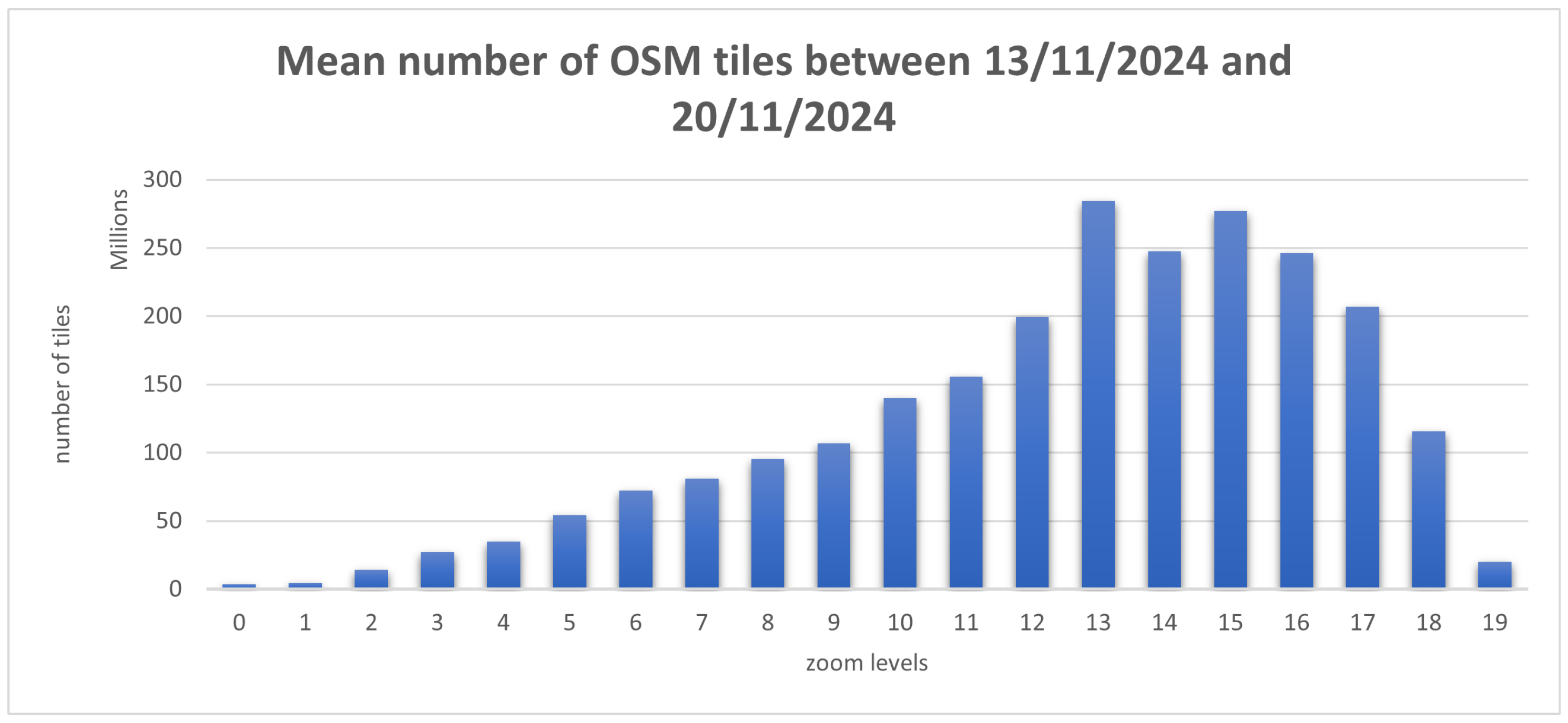
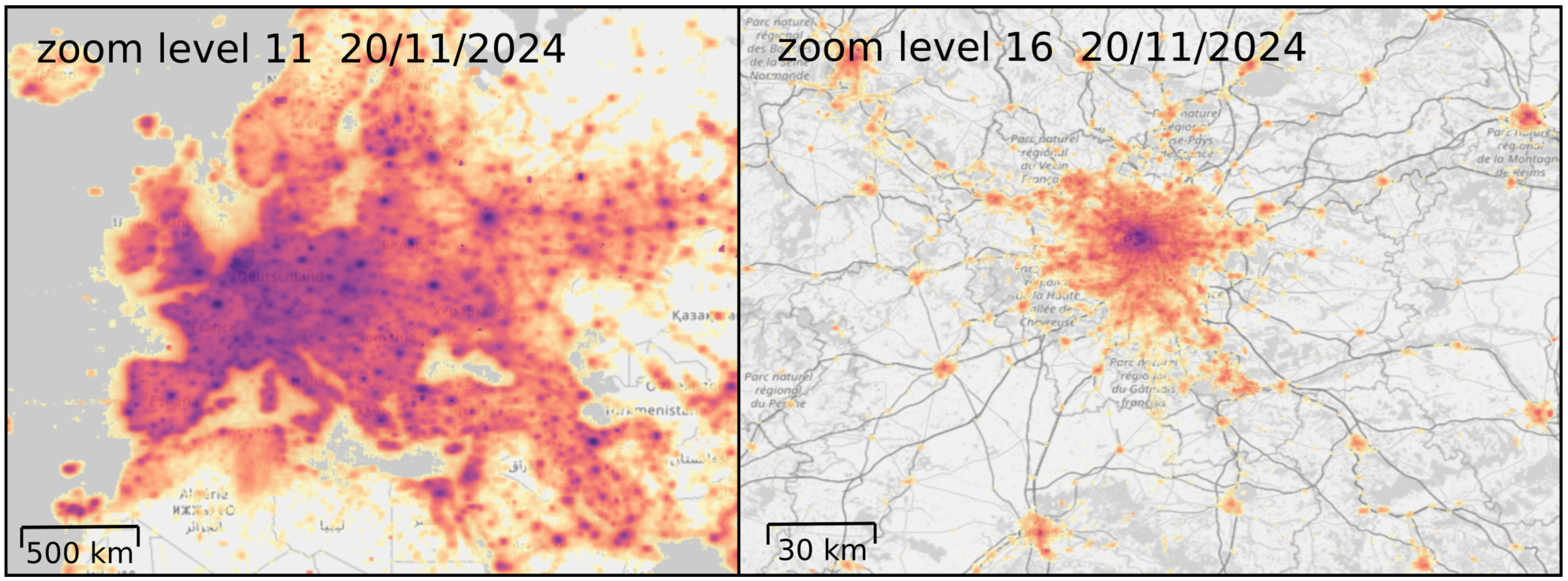
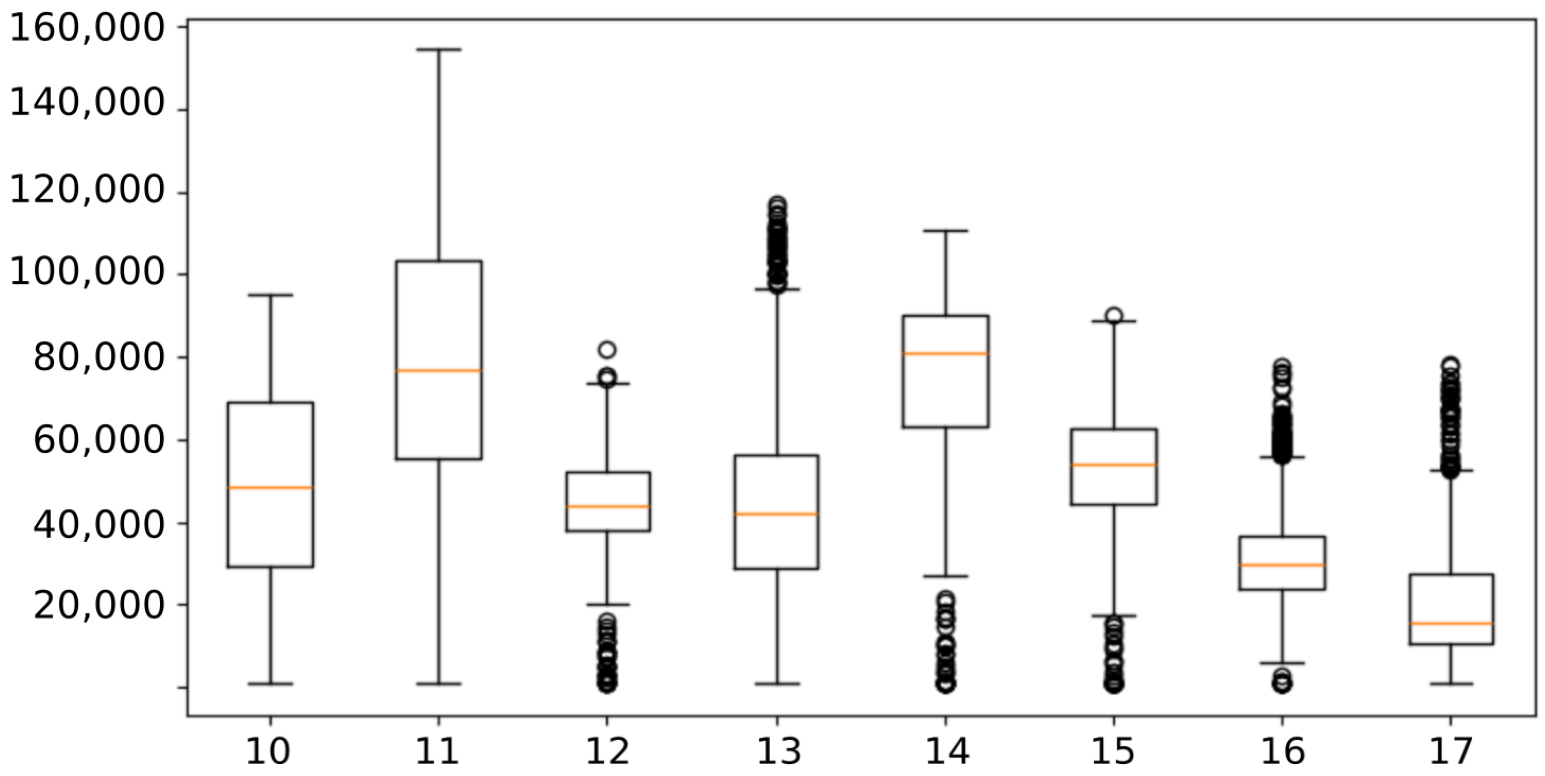
3.1. Materials and Methods
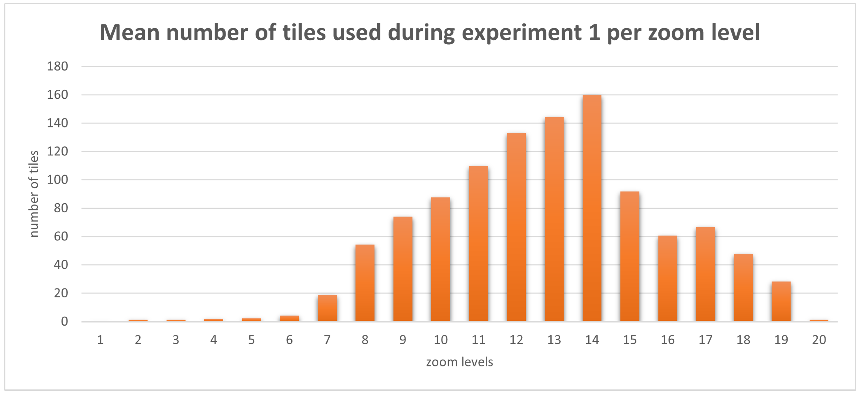
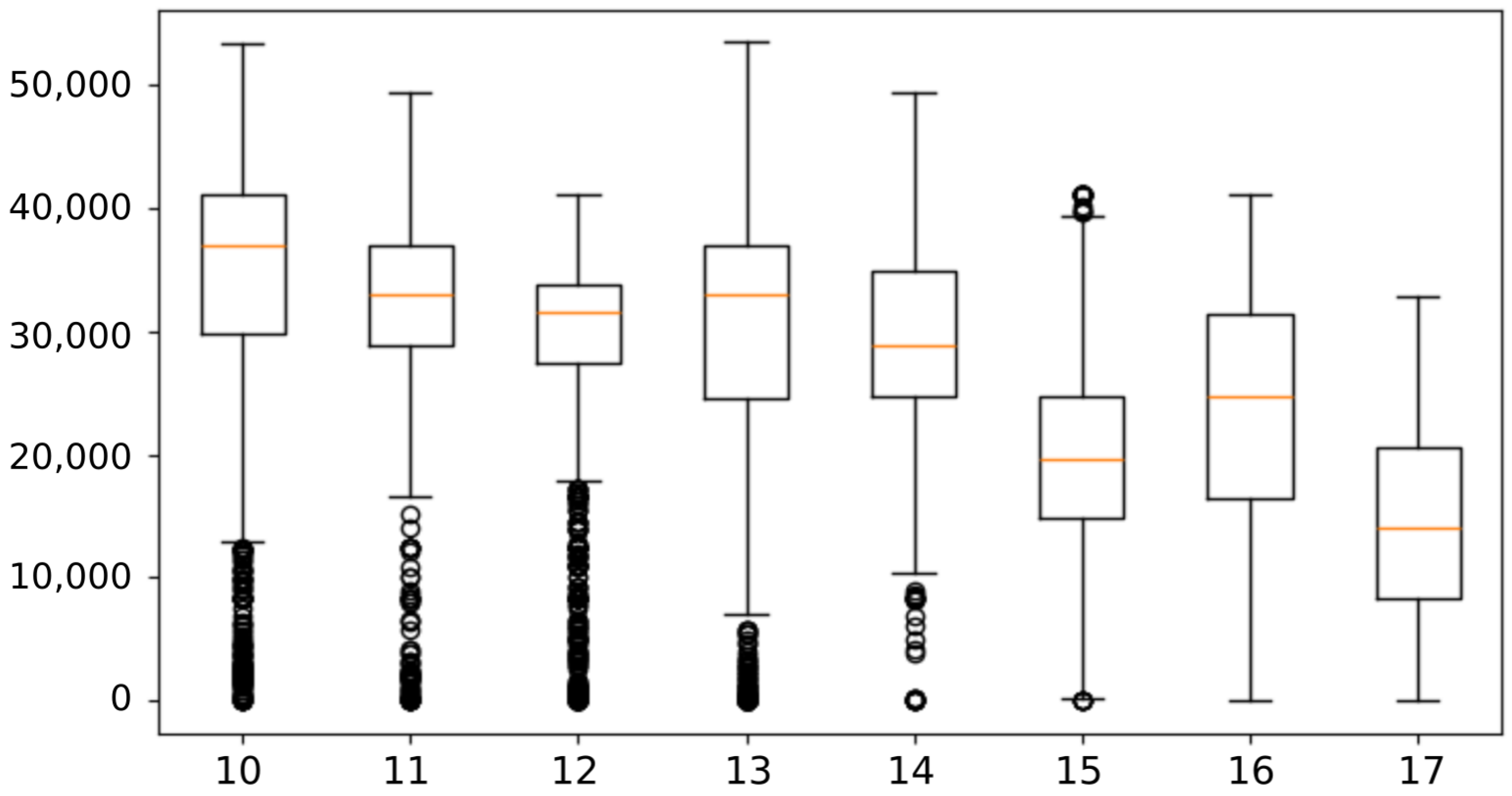
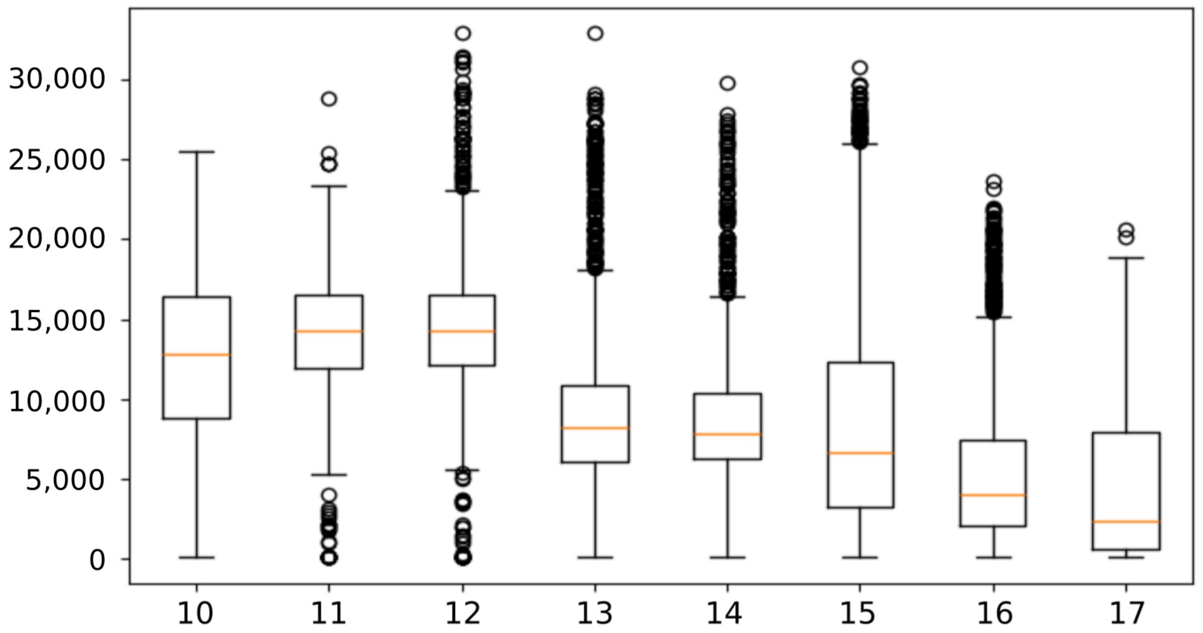
3.2. Results
3.3. Comparison with Past Studies
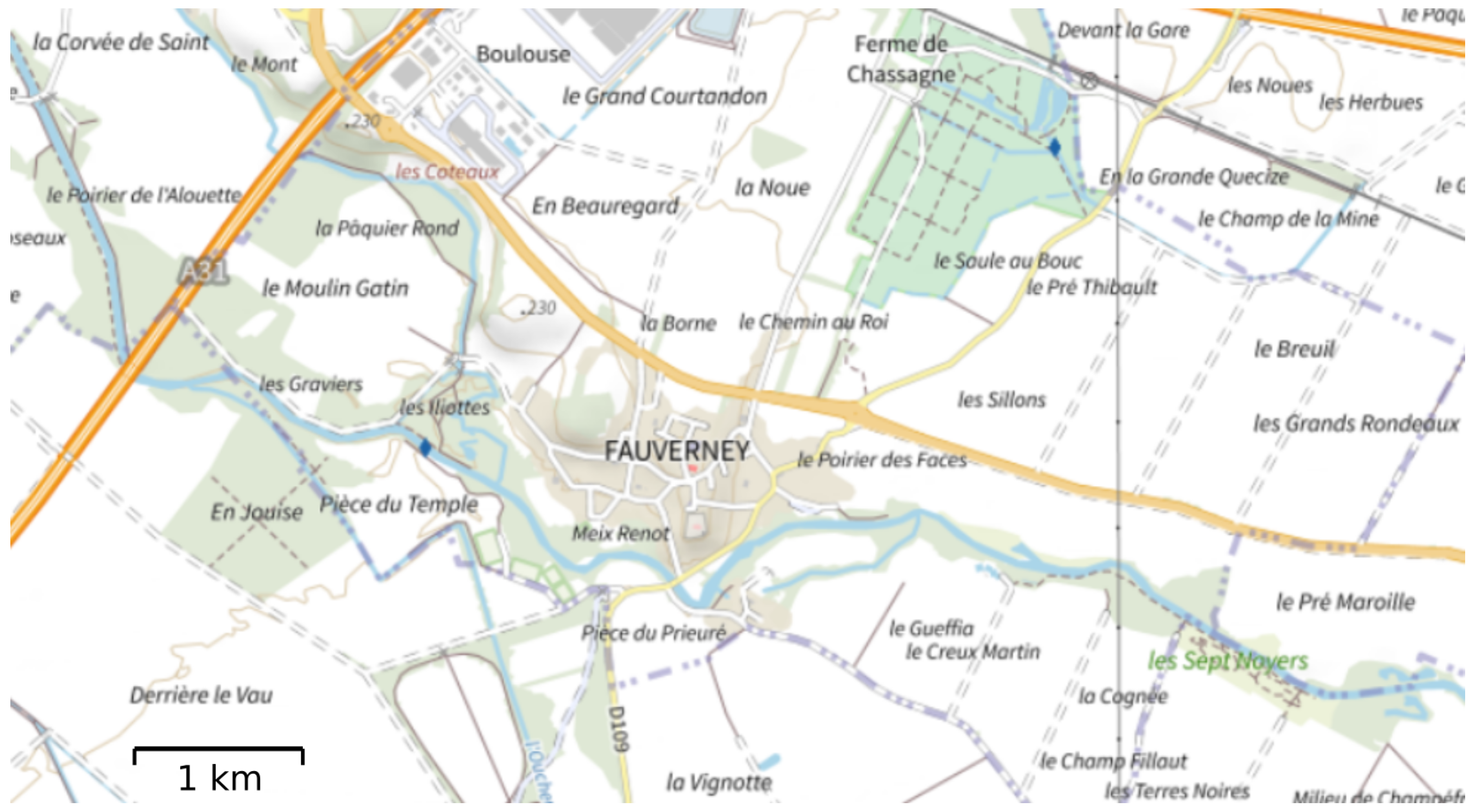
4. Comparing the Weight of Map Tiles
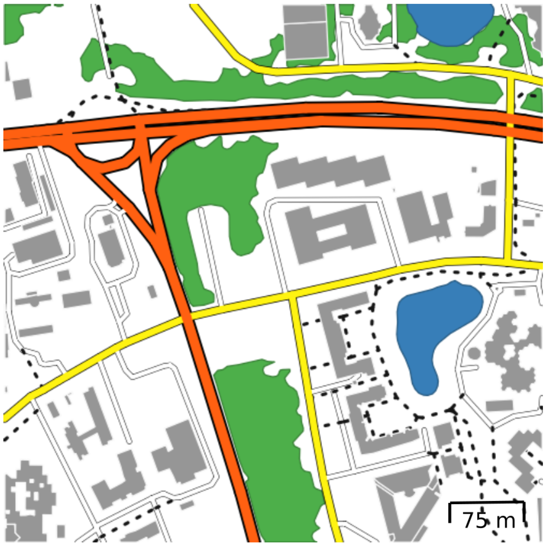
4.1. Materials and Methods
4.2. Results
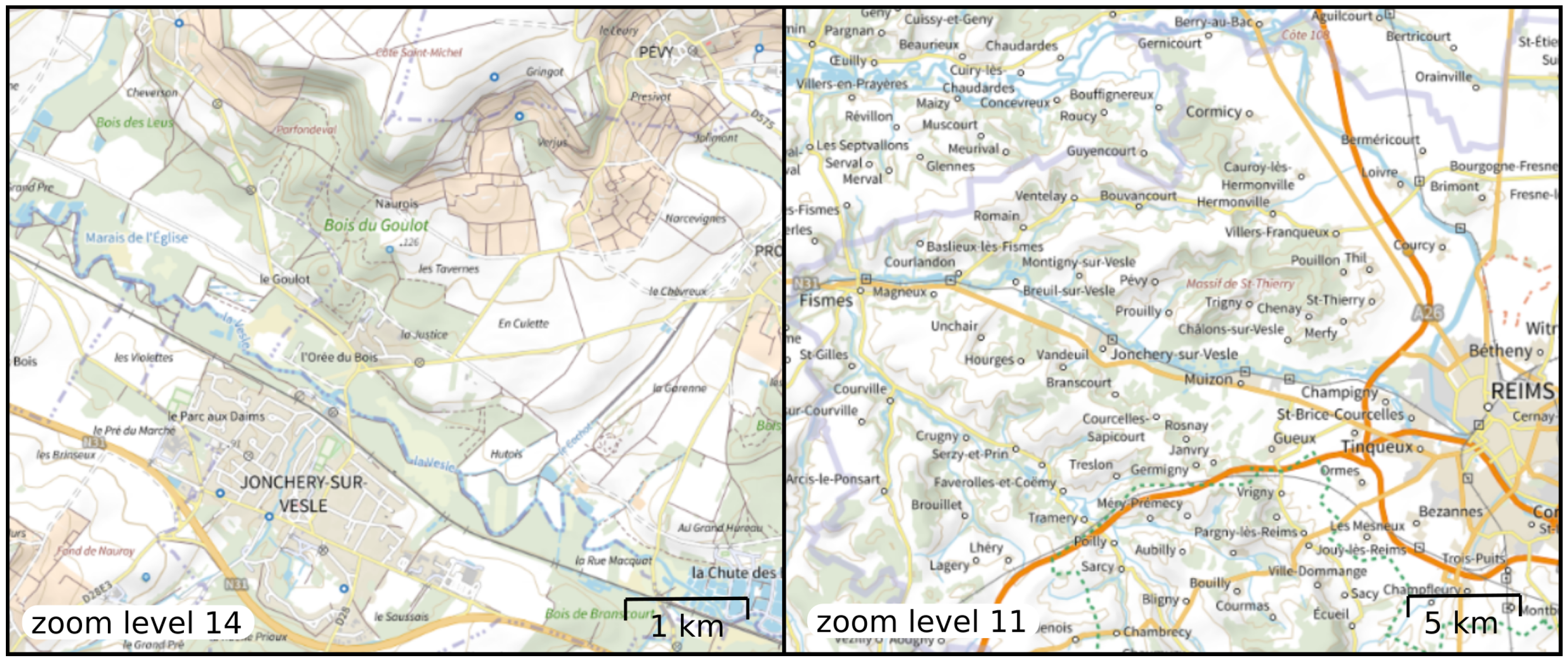
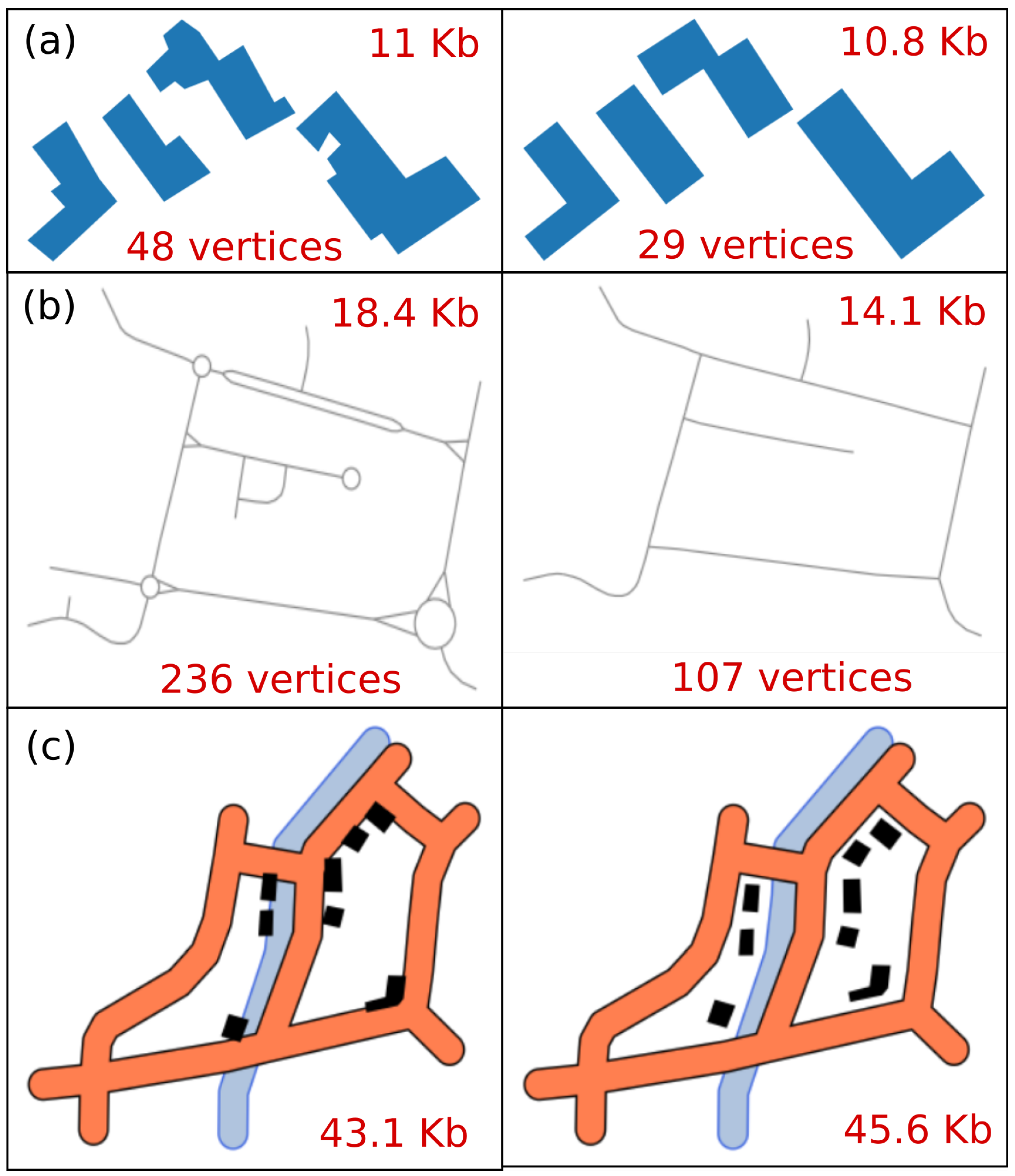
5. The Role of Map Generalization
6. Towards Energy-Efficient Maps
7. Conclusions
Author Contributions
Funding
Institutional Review Board Statement
Informed Consent Statement
Data Availability Statement
Conflicts of Interest
References
- Andrae, A.S.G.; Edler, T. On Global Electricity Usage of Communication Technology: Trends to 2030. Challenges 2015, 6, 117–157. [Google Scholar] [CrossRef]
- Williams, J.; Curtis, L. Green: The New Computing Coat of Arms? IT Prof. 2008, 10, 12–16. [Google Scholar] [CrossRef]
- Russell, E. 9 Things to Know About Google’s Maps Data: Beyond the Map. 2019. Available online: https://mapsplatform.google.com/resources/blog/9-things-know-about-googles-maps-data-beyond-map/ (accessed on 18 December 2024).
- Wu, M.; Lv, G.; Qiao, L.; Roth, R.E.; Zhu, A.X. Green Cartography: A research agenda towards sustainable development. Ann. GIS 2024, 30, 15–34. [Google Scholar] [CrossRef]
- Han, Y.; Wu, M.; Roth, R. Toward green cartography & visualization: A semantically-enriched method of generating energy-aware color schemes for digital maps. Cartogr. Geogr. Inf. Sci. 2021, 48, 43–62. [Google Scholar] [CrossRef]
- Wu, M.; Lv, G.; Yuan, L. Green Cartography and Energy-Aware Maps: Possible Research Opportunities. In New Thinking in GIScience; Li, B., Shi, X., Zhu, A.X., Wang, C., Lin, H., Eds.; Springer Nature: Singapore, 2022; pp. 197–205. [Google Scholar] [CrossRef]
- Belkhir, L.; Elmeligi, A. Assessing ICT global emissions footprint: Trends to 2040 & recommendations. J. Clean. Prod. 2018, 177, 448–463. [Google Scholar] [CrossRef]
- Dong, M.; Zhong, L. Power Modeling and Optimization for OLED Displays. IEEE Trans. Mob. Comput. 2012, 11, 1587–1599. [Google Scholar] [CrossRef]
- Kent, A.J.; Vujakovic, P. Cartographic Language: Towards a New Paradigm for Understanding Stylistic Diversity in Topographic Maps. Cartogr. J. 2011, 48, 21–40. [Google Scholar] [CrossRef]
- Christophe, S.; Hoarau, C. Expressive Map Design Based on Pop Art: Revisit of Semiology of Graphics? Cartogr. Perspect. 2013, 73, 61–74. [Google Scholar] [CrossRef]
- Hoarau, C. Reaching a Compromise between Contextual Constraints and Cartographic Rules: Application to Sustainable Maps. Cartogr. Geogr. Inf. Sci. 2011, 38, 79–88. [Google Scholar] [CrossRef]
- Gaffuri, J. Toward Web Mapping with Vector Data. In Geographic Information Science; Xiao, N., Kwan, M.P., Goodchild, M.F., Shekhar, S., Eds.; Lecture Notes in Computer Science; Springer: Berlin/Heidelberg, Germany, 2012; Volume 7478, pp. 87–101. [Google Scholar] [CrossRef]
- Gaffuri, J. Improving Web Mapping with Generalization. Cartogr. Int. J. Geogr. Inf. Geovisualiz. 2011, 46, 83–91. [Google Scholar] [CrossRef]
- Balley, S.; Parent, C.; Spaccapietra, S. Modelling geographic data with multiple representations. Int. J. Geogr. Inf. Sci. 2004, 18, 327–352. [Google Scholar] [CrossRef]
- van Oosterom, P. Variable-scale Topological Data Structures Suitable for Progressive Data Transfer: The GAP-face Tree and GAP-edge Forest. Cartogr. Geogr. Inf. Sci. 2005, 32, 331–346. [Google Scholar] [CrossRef]
- Gruget, M.; Touya, G.; Muehlenhaus, I. Missing the city for buildings? A critical review of pan-scalar map generalization and design in contemporary zoomable maps. Int. J. Cartogr. 2023, 9, 255–285. [Google Scholar] [CrossRef]
- Dumont, M.; Touya, G.; Duchêne, C. Designing multi-scale maps: Lessons learned from existing practices. Int. J. Cartogr. 2020, 6, 121–151. [Google Scholar] [CrossRef]
- Courtial, A.; Touya, G. Does Generalisation Matters in Pan-Scalar Maps? In Proceedings of the 12th International Conference on Geographic Information Science (GIScience 2023), Leibniz International Proceedings in Informatics (LIPIcs), Leeds, UK, 12–15 September 2023; Volume 277, pp. 23:1–23:6. [Google Scholar] [CrossRef]
- Vieira, M.R.; Bakalov, P.; Hoel, E.; Tsotras, V.J. A Spatial Caching Framework for Map Operations in Geographical Information Systems. In Proceedings of the 2012 IEEE 13th International Conference on Mobile Data Management, Bengaluru, India, 23–26 July 2012; pp. 89–98. [Google Scholar] [CrossRef]
- Quinn, S.; Gahegan, M. A Predictive Model for Frequently Viewed Tiles in a Web Map. Trans. GIS 2010, 14, 193–216. [Google Scholar] [CrossRef]
- Pan, S.; Chong, Y.; Zhang, H.; Tan, X. A Global User-Driven Model for Tile Prefetching in Web Geographical Information Systems. PLoS ONE 2017, 12, e0170195. [Google Scholar] [CrossRef]
- Bertolotto, M.; Egenhofer, M. Progressive Transmission of Vector Map Data over the World Wide Web. GeoInformatica 2001, 5, 345–373. [Google Scholar] [CrossRef]
- Buttenfield, B. Transmitting Vector Geospatial Data across the Internet. In Geographic Information Science; Egenhofer, M., Mark, D., Eds.; Lecture Notes in Computer Science; Springer: Berlin/Heidelberg, Germany, 2002; Volume 2478, pp. 51–64. [Google Scholar] [CrossRef]
- Sester, M.; Brenner, C. A vocabulary for a multiscale process description for fast transmission and continuous visualization of spatial data. Comput. Geosci. 2009, 35, 2177–2184. [Google Scholar] [CrossRef]
- Antoniou, V.; Morley, J.; Haklay, M. Tiled Vectors: A Method for Vector Transmission over the Web. In Web and Wireless Geographical Information Systems; Carswell, J.D., Fotheringham., A.S., McArdle, G., Eds.; Lecture Notes in Computer Science; Springer: Berlin/Heidelberg, Germany, 2009; Volume 5886, pp. 56–71. [Google Scholar] [CrossRef]
- Corcoran, P.; Mooney, P. Topologically Consistent Selective Progressive Transmission. In Advancing Geoinformation Science for a Changing World; Geertman, S., Reinhardt, W., Toppen, F., Eds.; Lecture Notes in Geoinformation and Cartography; Springer: Berlin/Heidelberg, Germany, 2011; Volume 1, pp. 519–538. [Google Scholar] [CrossRef]
- Glueck, M.; Khan, A.; Wigdor, D.J. Dive in! Enabling progressive loading for real-time navigation of data visualizations. In Proceedings of the SIGCHI Conference on Human Factors in Computing Systems, CHI’14, Toronto, ON, Canada, 26 April–1 May 2014; pp. 561–570. [Google Scholar] [CrossRef]
- Potié, Q.; Touya, G.; Wenclik, L.; Mackaness, W. Browsing Map Browsers. Abstr. ICA 2024, 7, 130. [Google Scholar] [CrossRef]
- Braga, V.G.; Corr, S.L.; Rodrigues, V.J.d.S.; Cardoso, K.V. Characterizing User Behavior on Web Mapping Systems Using Real-World Data. In Proceedings of the 2018 IEEE Symposium on Computers and Communications (ISCC), Natal, Brazil, 25–28 June 2018; pp. 01056–01061. [Google Scholar] [CrossRef]
- Douglas, D.H.; Peucker, T.K. Algorithms for the Reduction of the Number of Points Required to Represent a Digitized Line or its Caricature. Cartogr. Int. J. Geogr. Inf. Geovisualiz. 1973, 10, 112–122. [Google Scholar] [CrossRef]
- Visvalingam, M.; Wyatt, J.D. Line Generalization by Repeated Elimination of Points. Cartogr. J. 1993, 30, 46–51. [Google Scholar] [CrossRef]
- Barrault, M.; Regnauld, N.; Duchêne, C.; Haire, K.; Baeijs, C.; Demazeau, Y.; Hardy, P.; Mackaness, W.A.; Ruas, A.; Weibel, R. Integrating multi-agent, object-oriented, and algorithmic techniques for improved automated map generalisation. In Proceedings of the 20th International Cartographic Conference, ICA, Beijing, China, 6–10 August 2001; Volume 3, pp. 2110–2116. [Google Scholar]
- Touya, G. A Road Network Selection Process Based on Data Enrichment and Structure Detection. Trans. GIS 2010, 14, 595–614. [Google Scholar] [CrossRef]
- Harrie, L.E. The Constraint Method for Solving Spatial Conflicts in Cartographic Generalization. Cartogr. Geogr. Inf. Sci. 1999, 26, 55–69. [Google Scholar] [CrossRef]
- Sester, M. Generalization Based on Least Squares Adjustment. Int. Arch. Photogramm. Remote. Sens. 2000, 33, 931–938. [Google Scholar]
- Kilpeläinen, L.T.; Sarjakoski, T. Incremental generalization for multiple representations of geographic objects. In GIS and Generalization: Methodology and Practise; Muller, J.C., Lagrange, J.P., Weibel, R., Eds.; Taylor & Francis: London, UK, 1995; pp. 209–218. [Google Scholar]
- Harrie, L.E.; Hellström, A.K. A Prototype System for Propagating Updates Between Cartographic Data Sets. Cartogr. J. 1999, 36, 133–140. [Google Scholar] [CrossRef]
- Skogan, D. Towards a Rule-based Incremental Generalization System. In Proceedings of the 5th AGILE Conference on Geographic Information Science, Palma, Spain, 25–27 April 2002. [Google Scholar]
- Lecordix, F.; Lemarié, C. Managing Generalisation Updates in IGN Map Production. In Generalisation of Geographic Information; Mackaness, W.A., Ruas, A., Sarjakoski, L.T., Eds.; Elsevier: Amsterdam, The Netherlands, 2007; pp. 285–300. [Google Scholar] [CrossRef]
- Anders, K.H.; Sester, M.; Bobrich, J. Incremental Update in a MRDB. In Proceedings of the 23rd International Cartographic Conference, ICA, Moscow, Russia, 4–10 August 2007. [Google Scholar]
- Haunert, J.H.; Anders, K.H.; Sester, M. Hierarchical Structures for Rule-Based Incremental Generalisation. In Proceedings of the ISPRS Archives XXXVI Working Group II/2, Beijing, China, 3–11 July 2008. [Google Scholar]
- Zhou, S.; Regnauld, N.; Roensdorf, C. Towards a Data Model for Update Propagation in MR-DLM. In Proceedings of the 11th ICA Workshop on Generalisation and Multiple Representation, ICA, Montpellier, France, 20–21 June 2008. [Google Scholar]
- Straupis, T. Optimisation of generalisation re-calculation using partitioning. Abstr. ICA 2022, 5, 83. [Google Scholar] [CrossRef]
- Rosenholtz, R. Capabilities and Limitations of Peripheral Vision. Annu. Rev. Vis. Sci. 2016, 2, 437–457. [Google Scholar] [CrossRef]
- Dumont, M.; Touya, G.; Duchêne, C. More is less—Adding zoom levels in multi-scale maps to reduce the need for zooming interactions. J. Spat. Inf. Sci. 2023, 27. [Google Scholar] [CrossRef]
- Popelka, S.; Vojtechovska, M.; Ruzicka, O.; Beitlova, M.; Stachon, Z. Adapting to the Mobile Majority: A New Approach to Interactive Map Usability Assessment. In Proceedings of the Online User Experiments: Seeing What Map Users See Without Seeing Them, Vienna, Austria, 9 September 2024. [Google Scholar]
- Touya, G.; Brusq, R.; Campo, L.; Pech, V.; Wenclik, L. Recording the Use of Interactive Web Maps with ZoomTracker. Abstr. ICA 2024, 7, 176. [Google Scholar] [CrossRef]
- Krassanakis, V.; Cybulski, P. Eye Tracking Research in Cartography: Looking into the Future. ISPRS Int. J. Geo-Inf. 2021, 10, 411. [Google Scholar] [CrossRef]
- Fairbairn, D.; Hepburn, J. Eye-tracking in map use, map user and map usability research: What are we looking for? Int. J. Cartogr. 2023, 9, 231–254. [Google Scholar] [CrossRef]
- Krassanakis, V.; Misthos, L.M. Mouse Tracking as a Method for Examining the Perception and Cognition of Digital Maps. Digital 2023, 3, 127–136. [Google Scholar] [CrossRef]


| ID | Browsing Behavior | Number of Participants | Expected Impact on Tiles |
|---|---|---|---|
| BB1 | small zoom with mouse wheel | 1 | many tiles loaded at intermediary scales |
| BB2 | trackpad | 1 | more tiles loaded due to clumsy interactions |
| BB3 | no panning | 1 | more tiles due to unnecessary interactions |
| BB4 | mostly panning | 1 | more tiles loaded due to a slow journey to the target |
| BB5 | center then zoom | 4 | fewer tiles due to a more precise zoom |
| BB6 | window zoom | 1 | fewer tiles due to a more precise zoom |
| Browsing Behavior | Completion Time | Loaded Tiles | Tiles per Second |
|---|---|---|---|
| BB1 | 174 | 975 | 5.6 |
| BB2 | 153 | 1383 | 9.0 |
| BB3 | 195 | 1505 | 7.72 |
| BB4 | 195 | 762 | 3.91 |
| BB5-1 | 171 | 942 | 5.5 |
| BB5-2 | 333 | 1908 | 5.73 |
| BB5-3 | 222 | 620 | 2.78 |
| BB5-4 | 90 | 993 | 11.03 |
| BB6 | 53 | 648 | 12.2 |
| Layer | Initial Size | After Attribute Simplification | After Generalization |
|---|---|---|---|
| roads | 71.9 | 67.3 | 51.6 |
| buildings | 58.7 | 56.3 | 42.0 |
| water | 5.29 | 5.20 | 3.04 |
| vegetation | 23.3 | 23.1 | 6.91 |
| complete map | 159.19 | 151.9 | 103.55 |
Disclaimer/Publisher’s Note: The statements, opinions and data contained in all publications are solely those of the individual author(s) and contributor(s) and not of MDPI and/or the editor(s). MDPI and/or the editor(s) disclaim responsibility for any injury to people or property resulting from any ideas, methods, instructions or products referred to in the content. |
© 2025 by the authors. Published by MDPI on behalf of the International Society for Photogrammetry and Remote Sensing. Licensee MDPI, Basel, Switzerland. This article is an open access article distributed under the terms and conditions of the Creative Commons Attribution (CC BY) license (https://creativecommons.org/licenses/by/4.0/).
Share and Cite
Touya, G.; Courtial, A.; Kalsron, J.; Berli, J.; Le Mao, B.; Wenclik, L. Understanding the Carbon Footprint of Tile Transfer for Web Maps. ISPRS Int. J. Geo-Inf. 2025, 14, 107. https://doi.org/10.3390/ijgi14030107
Touya G, Courtial A, Kalsron J, Berli J, Le Mao B, Wenclik L. Understanding the Carbon Footprint of Tile Transfer for Web Maps. ISPRS International Journal of Geo-Information. 2025; 14(3):107. https://doi.org/10.3390/ijgi14030107
Chicago/Turabian StyleTouya, Guillaume, Azelle Courtial, Jérémy Kalsron, Justin Berli, Bérénice Le Mao, and Laura Wenclik. 2025. "Understanding the Carbon Footprint of Tile Transfer for Web Maps" ISPRS International Journal of Geo-Information 14, no. 3: 107. https://doi.org/10.3390/ijgi14030107
APA StyleTouya, G., Courtial, A., Kalsron, J., Berli, J., Le Mao, B., & Wenclik, L. (2025). Understanding the Carbon Footprint of Tile Transfer for Web Maps. ISPRS International Journal of Geo-Information, 14(3), 107. https://doi.org/10.3390/ijgi14030107