4.1. Comprehensive Evaluation of Flood Disaster Resilience Levels
This section utilizes the entropy method to conduct a comprehensive evaluation of the flood disaster resilience levels in the Central Plains Urban Agglomeration. By applying Formulas (2)–(8), the assessment results for , , , , , and R for the 30 prefecture-level cities in the Central Plains from 2012 to 2021 were obtained. Based on these results, an analysis of the overall flood disaster resilience level, temporal evolution, and spatial variation in the Central Plains Urban Agglomeration is conducted. The specific results are analyzed as follows.
4.1.1. Temporal Evolution
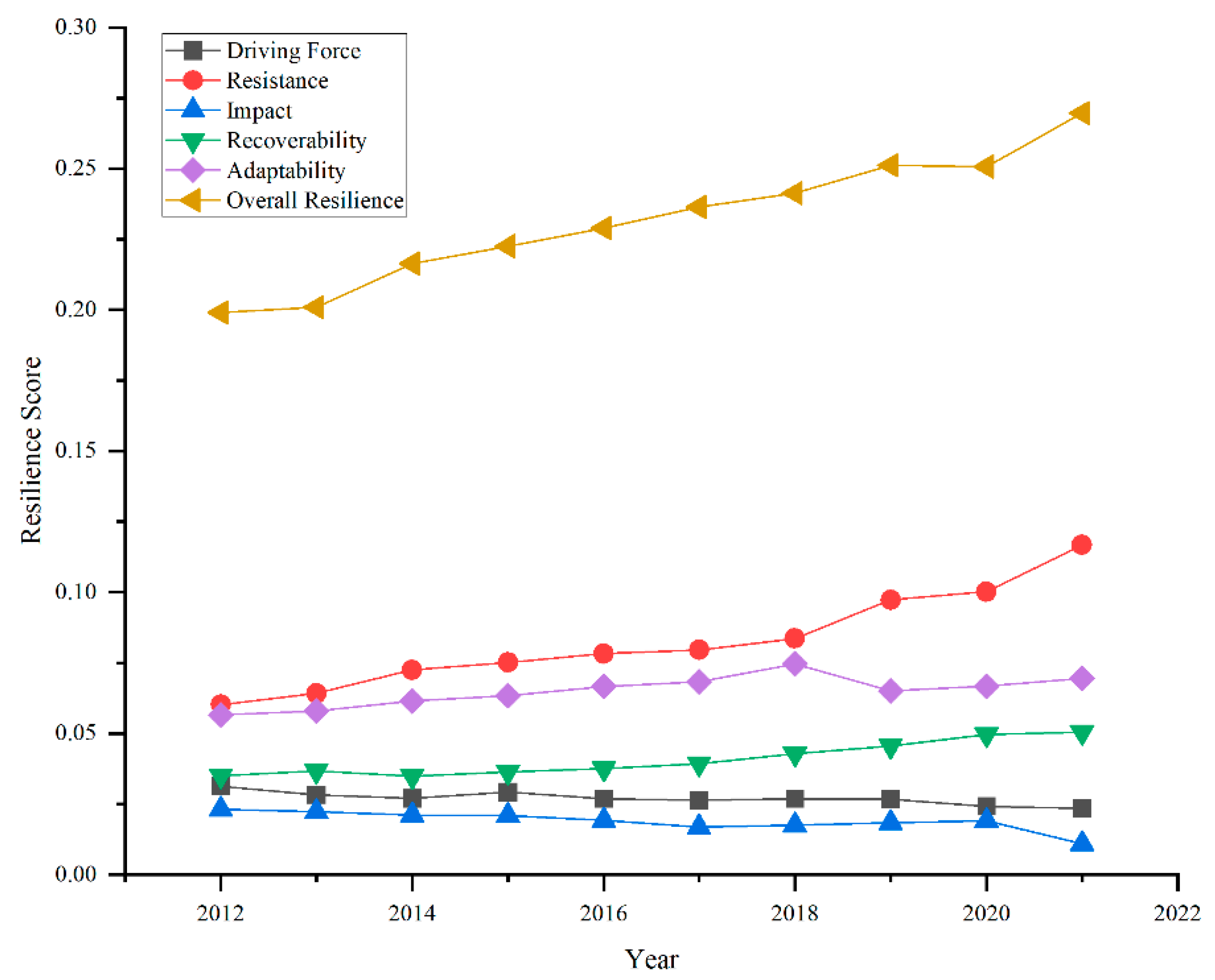
From an overall developmental trend perspective, the resilience level of flood disasters in the Central Plains Urban Agglomeration exhibited an upward trajectory from 2012 to 2021, increasing from 0.199 in 2012 to 0.2696 in 2021, representing a growth of 35.5% (as shown in
Figure 7). This indicates a transition of the overall resilience level from a low-resilience classification to a moderate-resilience classification. The continuous improvement in flood disaster resilience in the Central Plains Urban Agglomeration can be attributed to the ongoing socio-economic development and the emphasis on enhancing disaster management capabilities over the past decade, as well as the implementation of high-quality urban development policies. Comparing the average resilience scores across five dimensions reveals the following hierarchy: overall resilience > resistance resilience > adaptive resilience > recovery resilience > driving resilience > impact resilience. This pattern highlights the close relationship between the overall resilience enhancement of the urban agglomeration and the resilience, recovery capacity, and adaptability of urban systems. Although driving and impact factors exert direct negative effects on urban flood disaster resilience, their trends contrast sharply with the overall resilience score trends. The adverse impacts of flood disasters on urban systems are insufficient to undermine the development of urban resilience. Over the past decade, both adaptability and recoverability have steadily improved, indicating that positive results have been achieved across regions in terms of policy guidance and infrastructure development. In contrast, the impact indicator has shown significant fluctuations, suggesting that changes in the external environment continue to exert strong disturbances on urban resilience. Therefore, to enhance urban flood disaster resilience, it is crucial to focus on strengthening the inherent resistance, recovery, and adaptability levels of urban systems.
Although this study adopts the entropy weight method for indicator weighting, resulting in relatively higher weights assigned to economic income, infrastructure, and social security indicators, this does not imply a diminished role of natural factors in resilience building. Due to the limited spatial variability of natural factors such as topographic relief and annual precipitation within the Central Plains Urban Agglomeration, their information entropy contribution is relatively low, leading to smaller weights in the entropy-based calculation. However, from the perspective of the underlying mechanisms of flood risk identification and resilience enhancement, natural factors remain critically important. Specifically, topographic relief directly influences surface runoff convergence and the spatial distribution of flood-prone areas, serving as a key basis for spatial risk identification and flood prevention in urban settings. Annual precipitation reflects the frequency and intensity of regional extreme rainfall events, providing fundamental support for indicators related to the “resistance” and “adaptation” phases of resilience assessment. Moreover, land use changes and the expansion of impervious surfaces are closely linked to natural factors, constituting important variables that shape the dynamic evolution of urban resilience. Therefore, despite their lower weights in model calculations, natural elements such as topography and hydrology should be given due attention in practical strategies for resilience enhancement, particularly in the governance and optimization of these foundational environmental factors.
The results of this study indicate that from 2012 to 2021, the overall flood resilience of the Central Plains urban agglomeration has shown a steady upward trend. However, this improvement is primarily relative to past historical baselines. Against the backdrop of global climate warming, the frequency and intensity of extreme precipitation events are expected to increase significantly, leading to heightened flood risks for cities. Under such a trend, the current level of resilience may still be insufficient to effectively cope with more frequent or more severe flood impacts—especially in the face of compound, recurrent, or unprecedented extreme disasters, urban systems remain vulnerable. Therefore, flood resilience assessment should not only focus on current trends but also incorporate future climate change scenarios through contextualized simulations and stress testing, in order to comprehensively evaluate cities’ adaptive capacity and systemic stability under extreme events.
4.1.2. Spatial Evolution
As shown in
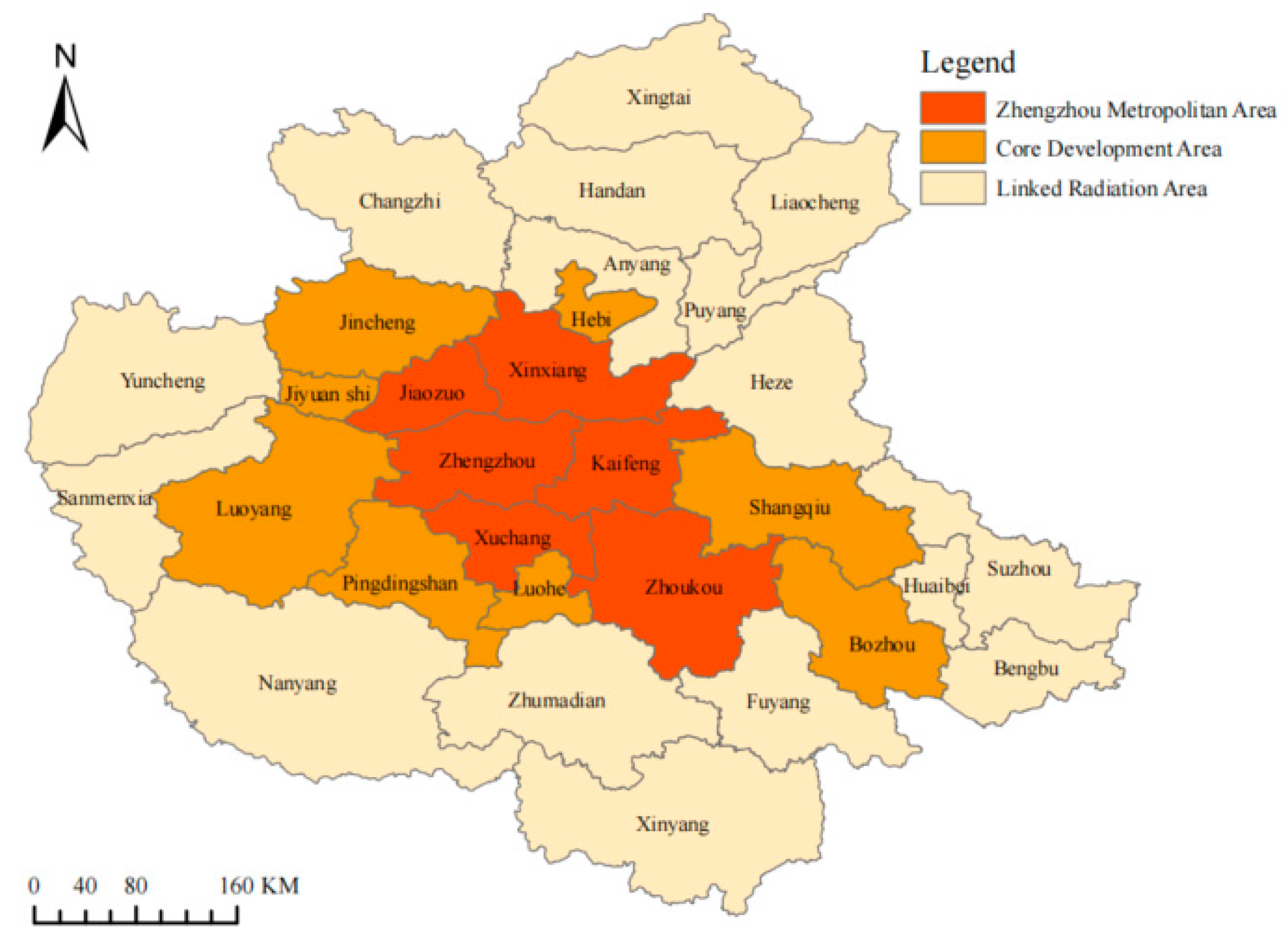
Figure 8, the spatial differentiation and evolution characteristics of flood disaster resilience levels in the Central Plains Urban Agglomeration are as follows: The “High-Low” categories were determined using the Natural Breaks method, which automatically sets thresholds based on data distribution, effectively revealing the spatial differences in flood resilience: Overall, the resilience levels of urban flood disasters tend to decrease from Zhengzhou to the surrounding areas. High-resilience cities are primarily concentrated in the Zhengzhou metropolitan area and the Luoyang urban agglomeration. This phenomenon can be attributed to Zhengzhou being the political and economic center of Henan Province, while Luoyang serves as a secondary center within the Central Plains Urban Agglomeration. Both cities have adopted complementary development strategies. Zhengzhou not only functions as the administrative center of the province but is also designated as a national-level central city, striving to become the regional economic core, a leading manufacturing base, a critical transportation hub, and an international cultural exchange platform. Thanks to its advantages in economic scale, structure, and innovation capacity, Zhengzhou and its neighboring cities have a more solid foundation for enhancing their flood disaster response capabilities. Over time, the number of cities with moderate resilience levels has gradually increased, while those with low and very low resilience levels have decreased. This trend indicates that the spatial differentiation pattern of urban flood disaster resilience in the Central Plains Urban Agglomeration is evolving toward a more balanced regional development. Overall, there is a growing trend in the resilience levels of cities within the Central Plains Urban Agglomeration. Overall, a “core-periphery” polarization pattern is observed. Zhengzhou, benefiting from the sponge city pilot program and favorable policy support, exhibits significantly higher resilience compared to surrounding areas. In contrast, peripheral cities face constraints in resilience improvement due to insufficient fiscal investment and lagging infrastructure development.
It is noteworthy that during the observation period from 2012 to 2021, the overall resilience of certain cities did not exhibit a linear upward trend; instead, some experienced notable declines or temporary regressions. Cities such as Xinxiang, Xuchang, Jiaozuo, Jincheng, and Nanyang showed significant drops in resilience levels in specific years, highlighting critical shortcomings in coping with extreme climatic shocks and in adapting urban systems. This trend likely reflects the interplay of multiple contributing factors. First, the lag in infrastructure investment and maintenance mechanisms, coupled with rapid urban expansion and high-intensity land development, has diminished natural rainwater retention spaces, thereby exacerbating flood risks. Meanwhile, the construction of drainage and flood control infrastructure has failed to keep pace, resulting in decreased indicators of resistance and recovery capacity. Second, in post-disaster governance, there is an overreliance on fiscal subsidies without adequate market-based mechanisms to complement recovery efforts. Moreover, these cities often prioritize physical reconstruction over institutional reform, lacking long-term capacity-building for adaptive governance. This imbalance has hindered improvements in recovery and adaptive capacities. Third, deficiencies in regional coordination mechanisms further compound the issue. Peripheral cities have struggled to integrate effectively into regional disaster prevention and mitigation frameworks, thereby missing out on critical external support resources. Thus, the differentiated evolution of urban flood resilience is not merely a reflection of engineering capabilities but is deeply rooted in outdated planning paradigms, institutional shortcomings, and the uneven allocation of governance resources. Enhancing urban resilience should not be confined to the question of “what to build,” but rather focus on “how to govern”—achieved through conceptual innovation, institutional synergy, and systemic mechanism reform to realize a comprehensive and transformative upgrade.
4.4. Analysis of Coupling Coordination of Flood Disaster Resilience
The sub-dimensions of urban flood disaster resilience—driving force resistance, impact, recoverability, and adaptability—interact, promote, and constrain each other, forming a typical coupled relationship. These dimensions exhibit a nonlinear interrelationship. Therefore, this section employs the coupling coordination degree model Equations (12)–(14) to explore the coordinated development level among the five dimensions of urban flood disaster resilience in the Central Plains Urban Agglomeration, based on the resilience assessments of drivability, resistance, impact, recovery, and adaptability from 2012 to 2021.
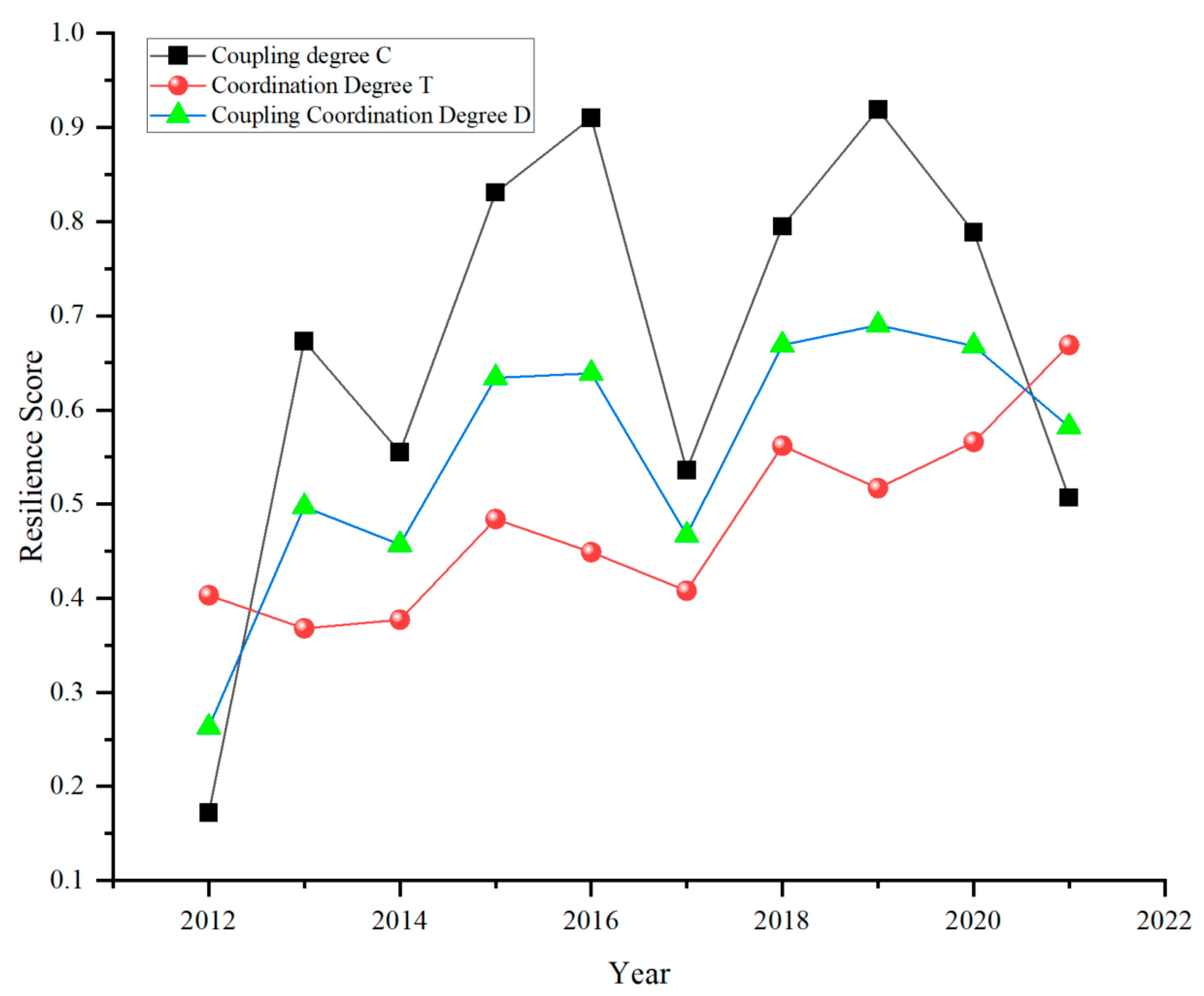
Overall, from 2012 to 2021, the coupling coordination level of the flood disaster resilience dimensions in the Central Plains Urban Agglomeration exhibited a fluctuating upward trend, as shown in
Figure 16. The coupling degree consistently remained higher than the coordination degree, and the gap between the two gradually narrowed, indicating an enhancement in overall cooperation and a trend toward positive development. The coupling degree (C) ranged from a maximum of 0.919 to a minimum of 0.172, experiencing three declines, but the overall impact was minimal, reflecting the increasing interconnection among the driving force, resistance, impact, recoverability, and adaptability dimensions. The variation in the coordination degree (T) followed a similar pattern to the coupling degree, with C decreasing and T increasing from 2020 onward. This suggests a weakening of the interactions between the five dimensions; however, the national investments in flood disaster management and improvements in infrastructure have strengthened urban resistance and recovery capabilities, thereby verifying the enhancement of the synergistic effects. Overall, the coupling coordination degree (D) increased from 0.263 to 0.669, representing a 154% growth, demonstrating a strengthening of the synergistic effects between the sub-dimensions. This shift indicates a gradual adjustment from moderate disequilibrium in 2012 to a state of marginal coordination. The coupling coordination degree between the sub-dimensions of urban flood disaster resilience has had a certain impact on the overall resilience level. From the evolution of the Central Plains Urban Agglomeration’s flood disaster resilience (
Figure 7), it can be seen that the years with smaller increases were 2013, 2018, and 2021. In contrast, the degree of coupling coordination declined in 2014, 2017, and 2021.
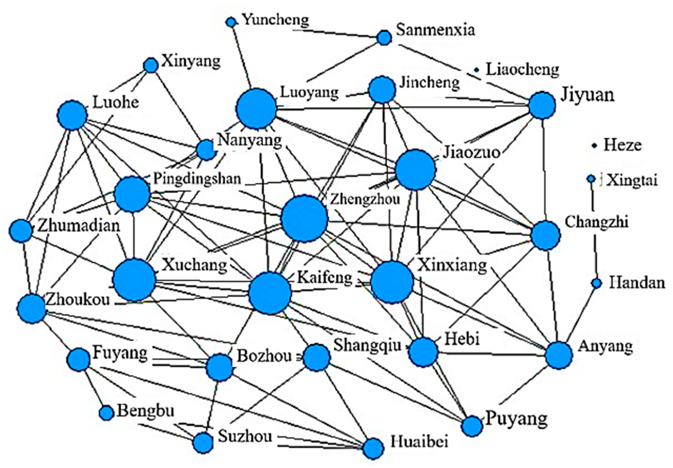
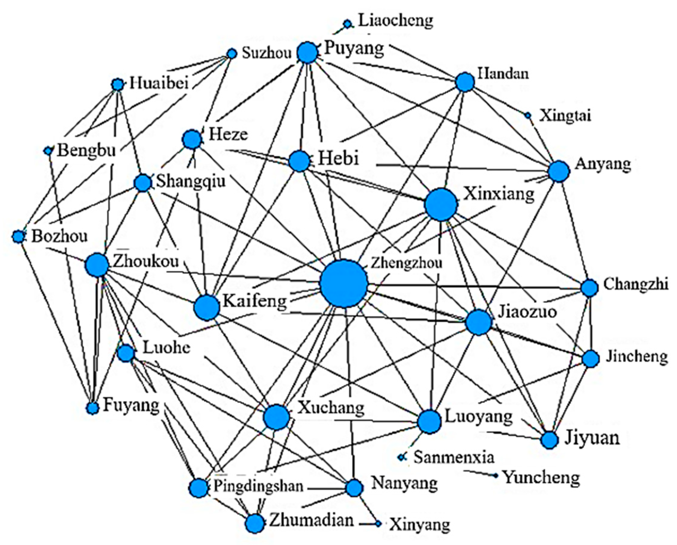
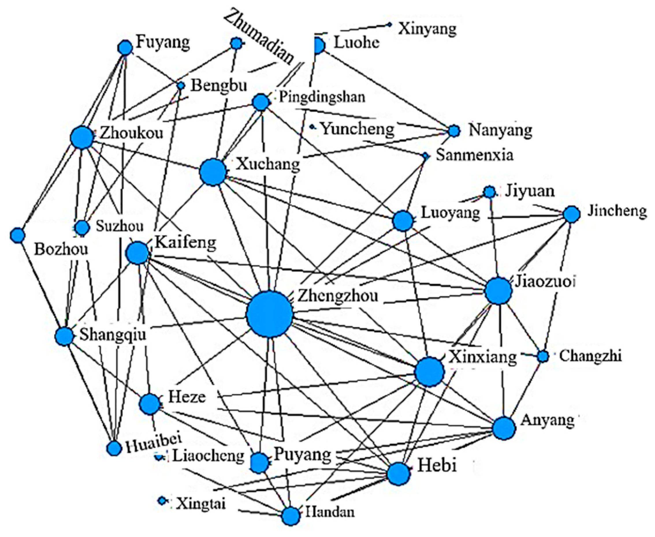
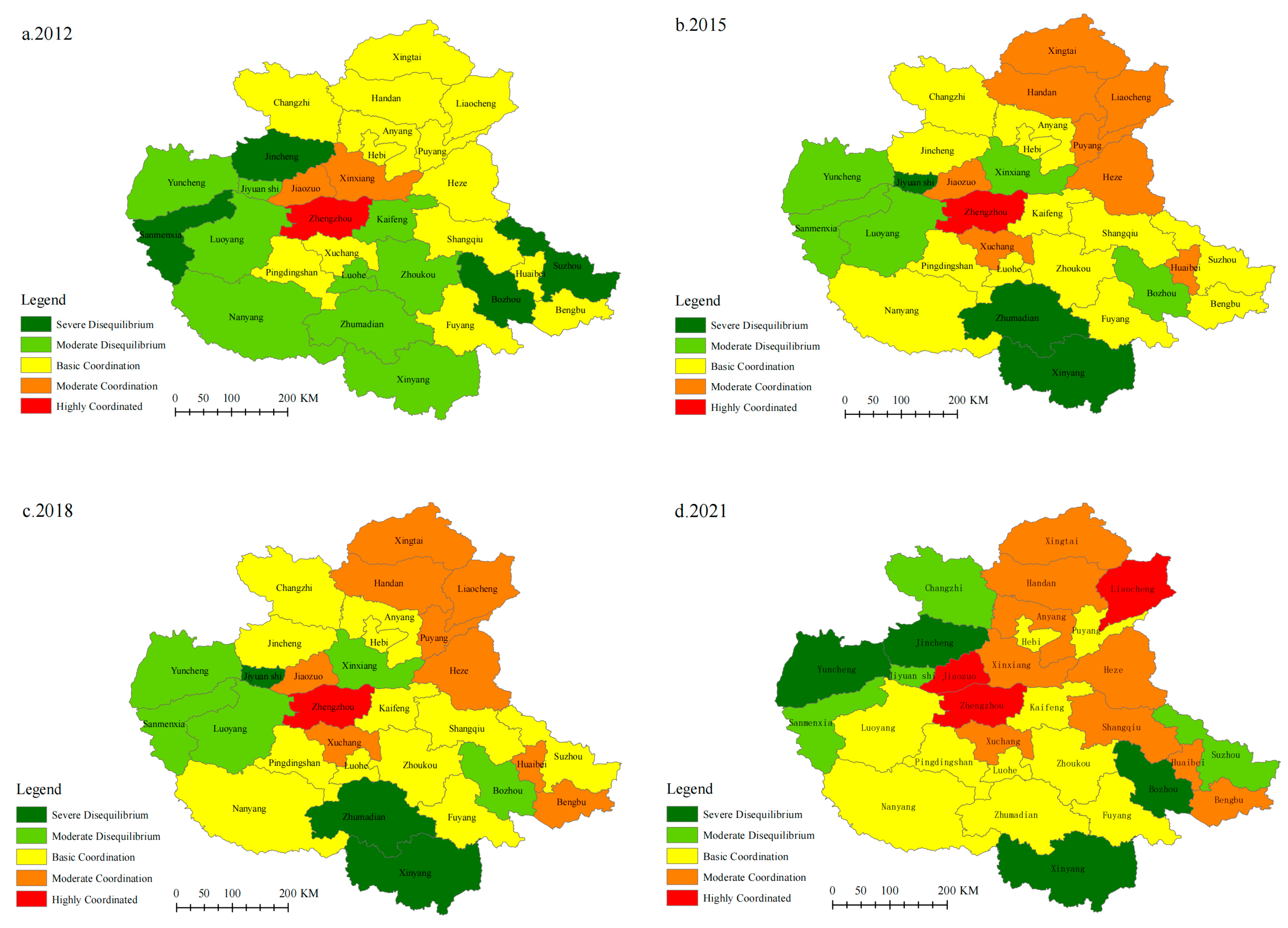
To more intuitively reflect the coupling coordination levels of flood disaster resilience across cities, the coupling coordination degree of 30 cities in the Central Plains Urban Agglomeration was classified for the years 2012, 2015, 2018, and 2021 using ArcGIS 10.8 software, as shown in
Figure 17.
The coupling and coordination of flood resilience in 30 cities of the Central Plains Urban Agglomeration across four key years exhibit a spatial distribution pattern of “high in the center, low at the periphery,” which is consistent with the distribution of flood resilience levels. This disparity is primarily driven by factors such as the cities’ natural conditions, development stages, and policy orientations. As the provincial capital, Zhengzhou possesses significant advantages in terms of economy, social security, and infrastructure, contributing to stronger flood resilience. Through spillover effects, Zhengzhou has driven the enhancement of resilience in surrounding cities such as Xuchang, Kaifeng, and Jiaozuo. These cities generally exhibit good coupling and coordination, focusing on high-quality development, optimizing functional layouts, accelerating industrial structure upgrades, and improving public service facilities and information networks. At the same time, they have prioritized strengthening their ability to respond to flood risks. For instance, in 2016, Zhengzhou implemented the “sponge city” concept, becoming a pilot for the province, which promoted the construction of a regional sponge city policy and management system. This initiative has set a model for regional development in the Central Plains, exploring new pathways for the area’s growth.
In contrast, peripheral cities such as Zhumadian, Xinyang, and Jiyuan exhibit lower resilience levels due to insufficient infrastructure, distance from central cities, and limitations on urbanization progress caused by natural conditions and economic structure. Consequently, their flood resilience coupling and coordination are relatively weak. Overall, the flood resilience in the Central Plains Urban Agglomeration presents a pattern of “prominent in the center, declining at the periphery.”
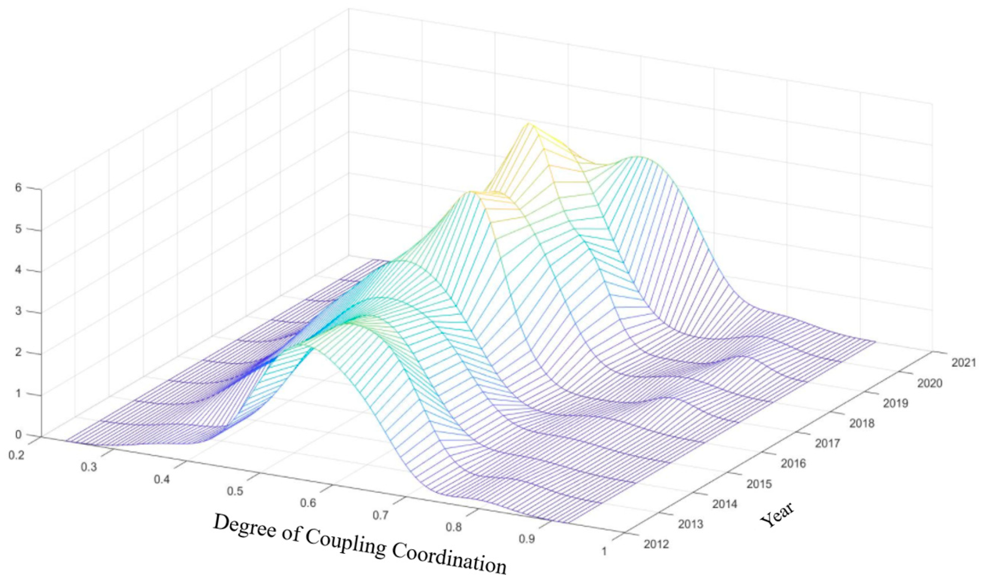
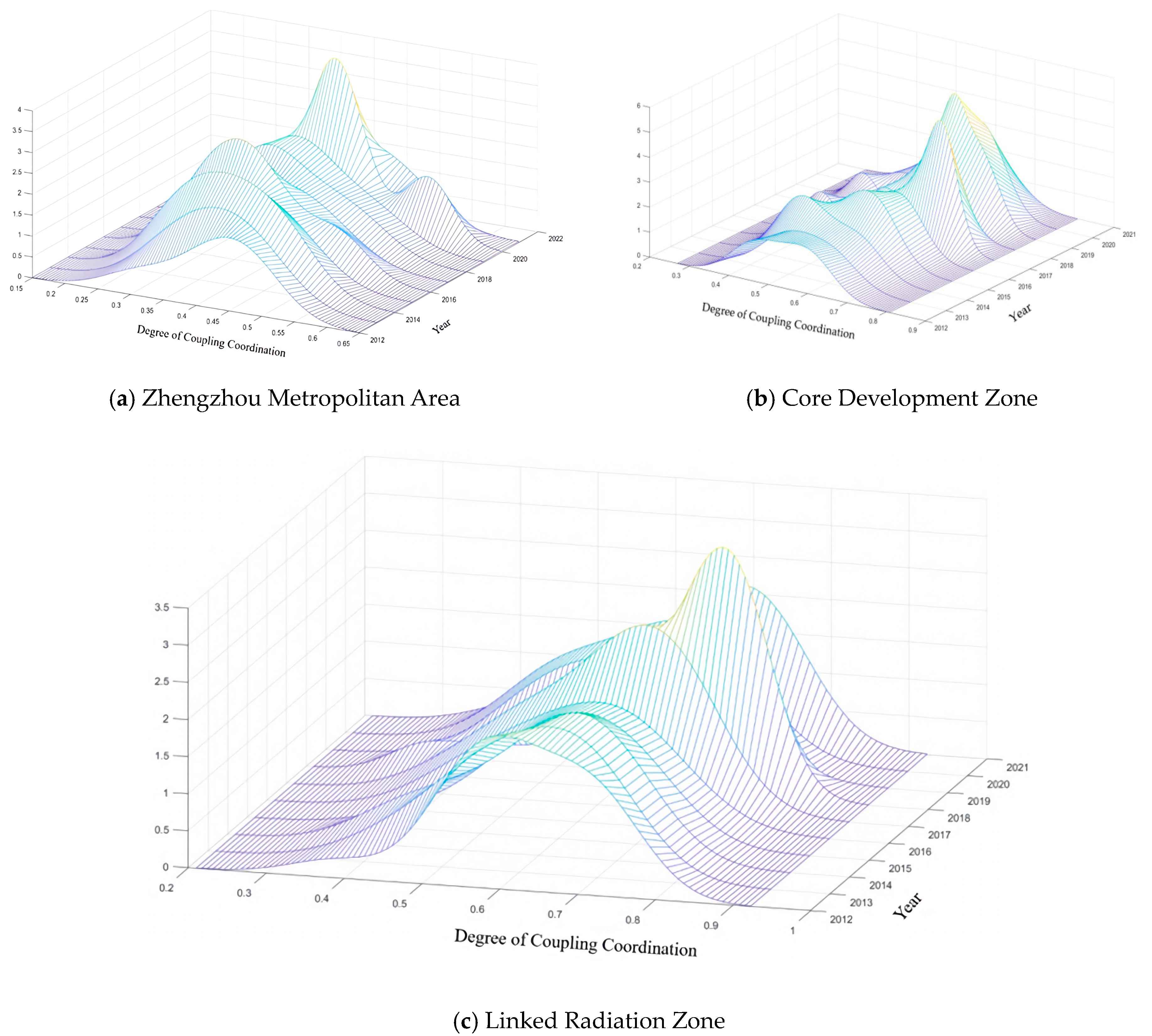
To visually and intuitively present the development level, distribution dynamics, extensibility, and polarization trends of the flood resilience coupling and coordination degree in the Central Plains Urban Agglomeration, this study depicts the three-dimensional dynamic Kernel density of flood resilience coupling and coordination degree in the region, as shown in
Figure 18 and
Figure 19.
Overall, as shown in
Figure 16, the development of the flood resilience coupling and coordination degree in the cities of the Central Plains Urban Agglomeration exhibits the following prominent characteristics: Firstly, from the perspective of distribution, the development level of the flood resilience coupling and coordination degree from 2012 to 2021 generally follows a curve of rightward shift followed by a leftward shift. This indicates a fluctuating upward trend in the coupling and coordination degree of flood resilience, which is consistent with the time-series analysis of the coupling and coordination degree across five dimensions of urban flood resilience in
Section 4.1.
From the perspective of peak characteristics, from 2012 to 2018, the peak fluctuations of the overall sample kernel density distribution curve showed an upward trend, reaching the highest value in 2019. The peak shape narrowed, shifting from a broad peak to a narrow peak. Afterward, the peak value decreased year by year, and the peak shape became broader, indicating that the absolute gap in the coupling and coordination degree of flood resilience in the Central Plains Urban Agglomeration first fluctuated and then decreased, before increasing again. Lastly, the number of peaks reflects the polarization characteristics of the kernel density function. In addition to a single peak, the kernel density distribution for the Central Plains cities exhibited a small secondary peak in the right tail in 2017 and 2019, along with a rightward skew, indicating a slight polarization phenomenon. Overall, despite the narrowing of regional disparities within the Central Plains Urban Agglomeration, the coupling and coordination degree of development remains unstable, influenced by the developmental differences in the earlier stages.
From the kernel density plots of the three major regions of the Central Plains Urban Agglomeration, as shown in
Figure 19, it can be observed that over the study period, the coupling and coordination degree of urban flood resilience in all three regions generally exhibited a rightward shift in their distribution. This indicates that the level of coupling and coordinated development of urban flood resilience in the three regions has been increasing.
Secondly, from the perspective of peak characteristics, overall, as time progresses, the kernel density curve shows a trend from a “flat” shape to a “tall” shape. This indicates that during the study period, the absolute gap and differentiation trend in coupling and coordination degree have been continuously narrowing. This also confirms the upward trend in the overall coupling and coordination degree of flood resilience in the Central Plains Urban Agglomeration, as discussed earlier. However, within the three major regions, the coupling and coordination degree value at the peak of the Zhengzhou Metropolitan Area is the lowest, suggesting that the coordinated development of urban flood resilience in this area lags behind that of the core development zone and the linked radiation zone. This phenomenon is closely related to the widening development gap between cities. In terms of the number of peaks, the kernel density curves of the core development zone and the linked radiation zone show a similar trend, with no significant secondary peaks apart from the main peak. However, in the Zhengzhou Metropolitan Area, noticeable secondary peaks appeared in 2016 and 2020, and by 2020, the kernel density curve of Zhengzhou showed a bimodal trend, indicating a severe polarization of the coupling and coordination degree in the Zhengzhou Metropolitan Area. In contrast, no significant polarization features are observed in the core development zone or the linked radiation zone.
Finally, from the perspective of distribution patterns, the Zhengzhou Metropolitan Area exhibits a distinct rightward skew, indicating a significant disparity in the level of coupling and coordination of urban flood resilience within the region. Some cities perform notably better than others. In contrast, neither the core development zone nor the linked radiation zone shows significant skewness, suggesting that these two regions exhibit more balanced levels of coupling and coordinated development. In summary, as time progresses, the coupling and coordination degree of urban flood resilience in the three major regions has steadily increased, with the gap gradually narrowing. However, attention should be paid to the need for more balanced development among cities within the Zhengzhou Metropolitan Area.
In summary, as time progresses, the coupling and coordination degree of urban flood resilience in the three major regions has steadily increased, with the gap gradually narrowing. From a policy perspective, this suggests that regional investments in infrastructure and governance coordination have been effective. However, the pronounced bimodal trend and skewness observed in the Zhengzhou Metropolitan Area highlight a risk of spatial polarization, where core cities advance while peripheral cities lag. This calls for targeted policies to promote balanced development, strengthen inter-city collaboration, and reduce internal disparities. By contrast, the more balanced distribution in the core development zone and linked radiation zone suggests that policy coordination in these areas has been more effective, offering useful lessons for addressing polarization in the Zhengzhou Metropolitan Area.
4.5. Recommendations for Response
- (1)
Promoting the Urban “Resilience·Sponge” Flood Prevention System
In urban flood management practices, it is imperative to bridge the existing gap between “sponge city” and “resilient city” initiatives, fostering their synergistic development to establish a comprehensive system encompassing flood prevention, drainage, recovery, and adaptation. Integrated Planning in Early Urban Development: During the initial stages of urban planning, it is crucial to simultaneously incorporate the rainwater harvesting and infiltration capabilities emphasized by sponge city concepts, along with the systemic connectivity and rapid recovery attributes central to resilient city frameworks. For instance, in the development of new urban areas, the concurrent design and implementation of sunken green spaces, ecological retention basins, and zoned drainage systems can preempt the inefficiencies associated with retrofitting infrastructure post-construction. Promotion of Multifunctional Green Infrastructure: The construction of green infrastructure with multiple functionalities should be encouraged. Urban parks, green roofs, and rain gardens that serve both ecological conservation and emergency flood detention purposes exemplify such dual-purpose designs. Integrating these green infrastructures with existing urban drainage networks and transportation systems ensures both physical and functional connectivity, thereby enhancing the overall efficiency and responsiveness of urban systems. Implementation of Smart Monitoring and Dynamic Management Systems: Leveraging technologies such as intelligent sensing and City Information Modeling (CIM), cities can develop real-time monitoring and dynamic scheduling platforms for urban waterlogging. These platforms can coordinate critical infrastructure components—including drainage pump stations, sluice gates, and traffic signals—to facilitate adaptive urban operations during flood events and expedite post-disaster recovery processes. Cities such as Zhengzhou and Xinxiang have taken the lead in launching sponge city pilot projects. Their experiences can be gradually replicated and promoted in the peripheral corridor cities, achieving significant runoff reduction with relatively low marginal investment, thereby narrowing the resilience gap between the core and peripheral areas.
By integrating the principles of sponge and resilient cities, urban areas can not only enhance their structural defenses against flood disasters but also improve their adaptability and resilience in the face of extreme climatic events. This holistic approach contributes to the sustainable advancement of urban systems at a systemic level [
57].
- (2)
Promoting Multimodal Flood Disaster Insurance
Data shows that the losses caused by flood disasters in a single event can be several to dozens of times greater than the total annual budget for disaster prevention and emergency management in the affected province or city [
58]. This indicates that the damage from flood disasters far exceeds local emergency management budgets, creating a significant financial impact on local governments. Given this context, there is an urgent need to shift away from disaster relief mechanisms primarily based on central government fiscal transfers and to leverage the function of market-based insurance mechanisms. In the implementation of this approach, the following aspects should be considered: first, increasing agricultural insurance coverage and improving the structural rationality of commercial property insurance; second, expanding the coverage of policy-based agricultural and rural housing insurance; and third, increasing the coverage limits of local disaster insurance plans. This initiative will not only establish a new insurance framework to enhance urban disaster resilience but is also expected to play a critical role in protecting the safety of people’s livelihoods and production [
58]. In high-asset-intensive areas such as the Zhengzhou metropolitan region, pilot programs for parametric catastrophe insurance can be prioritized. In contrast, in peripheral agricultural areas and small- to medium-sized cities, the focus should first be on expanding the coverage of agricultural insurance and rural housing insurance. The national requirements for grain crop insurance coverage can also serve as a reference for regional promotion.
- (3)
Strengthening Post-Disaster Economic Support and Investment
Economic support and investment are crucial safeguards for managing flood disasters and serve as a significant driving force for long-term post-disaster recovery and reconstruction. First, optimizing the structure of fiscal expenditures and adjusting the allocation of the fiscal budget to direct more funds toward disaster management and response measures is essential. Second, a sound funding allocation mechanism should be established to ensure that funds are distributed fairly and efficiently. Different funding allocation standards should be developed based on the severity of the disaster and local needs, with priority given to heavily affected regions and key projects to maximize the effectiveness of fund utilization. In addition, given the disparities in fiscal capacity observed across cities, exploring ways to involve social capital in post-disaster recovery and reconstruction may provide a useful supplement to government investment. Potential approaches, such as tax incentives, guidance funds, or bond issuance, could be considered in future practice to encourage private sector engagement, although further empirical evidence is needed to support these measures. Core cities such as Zhengzhou and Luoyang can prioritize allocating more local fiscal resources and special funds to drainage system renovation and resilience infrastructure upgrades. In contrast, peripheral cities with weaker fiscal capacity need to rely more on provincial transfer payments and attract private capital through the PPP model, so as to avoid widening the inter-city gap due to post-disaster investment pressures.
- (4)
Implementing regular and extraordinary emergency management
Routine emergency management should focus on continuously updating and refining flood emergency plans for extreme rainfall events. This includes improving city-specific “one plan for one site” responses, strengthening evacuation and relocation strategies, and conducting regular flood defense drills. At the same time, risk monitoring and assessment must be institutionalized to identify latent hazards, complemented by measures such as drainage upgrading, soil erosion control, and rational land-use planning. Extraordinary emergency management requires establishing a clear response mechanism with well-defined responsibilities across different levels of government and departments, ensuring rapid activation of emergency procedures, and securing adequate reserves of supplies and equipment. Timely evacuation, rescue, and post-disaster recovery are critical for restoring damaged infrastructure and resuming normal life and production. Beyond individual cities, regional coordinated emergency management is essential. Within the Central Plains Urban Agglomeration, a “core emergency corridor” can be established along the Zhengzhou–Luoyang–Kaifeng axis, responsible for early warning dissemination, CIM-based smart monitoring, and material support. Peripheral cities such as Jiaozuo and Xuchang could connect to this corridor through data sharing and unified relocation protocols, thereby forming a core–periphery linkage pattern. This structure would enhance overall systemic efficiency and reduce the risk of fragmented responses under extreme rainfall events.
