Evaluation of Underground Space Resources in Ancient Cities from the Perspective of Organic Renewal: A Case Study of Shaoxing Ancient City
Abstract
1. Introduction
2. Literature Review
3. Study Area and Data Source
3.1. Study Area
3.2. Data Sources
4. Methodology
4.1. Scope and Objectives of the Evaluation
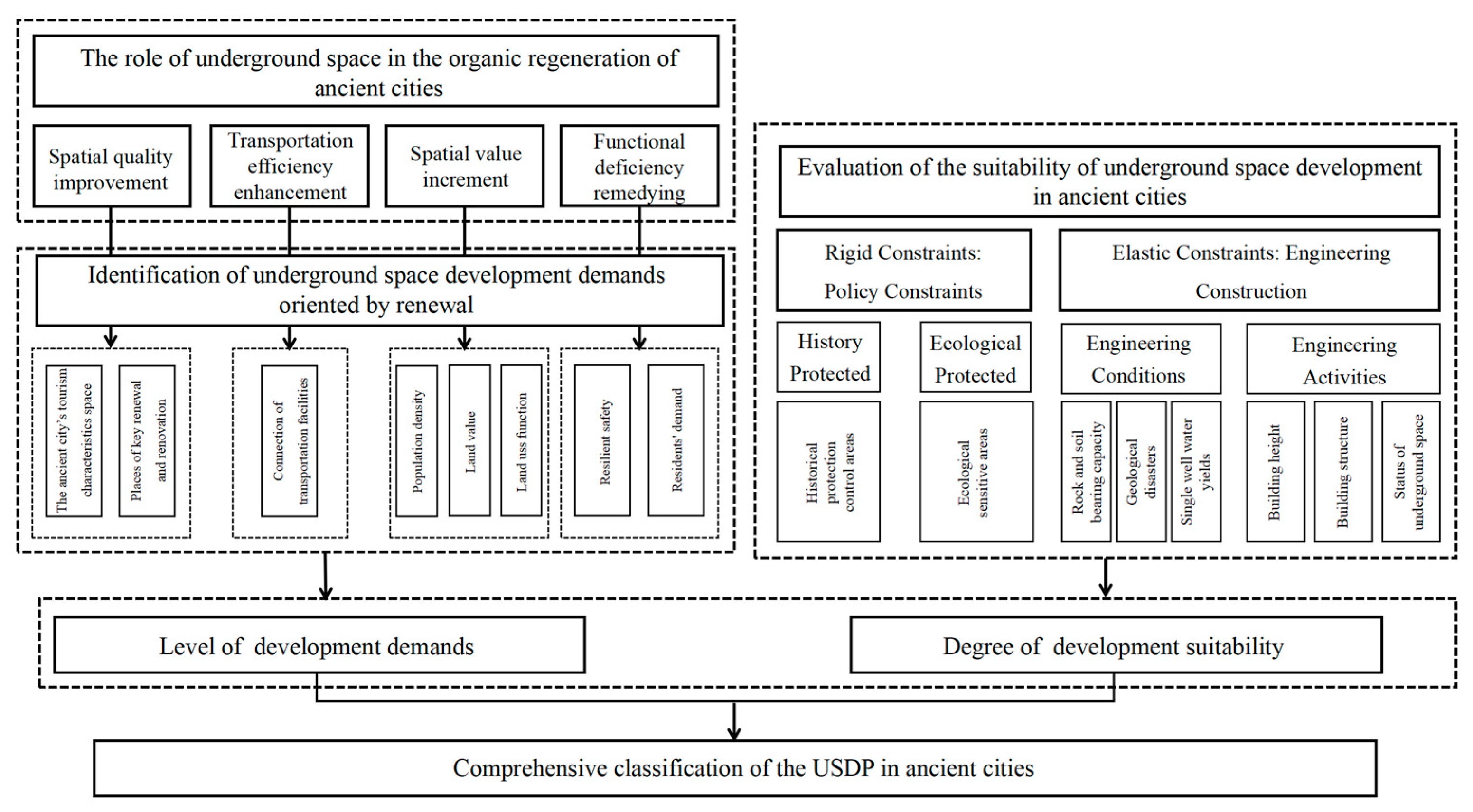
4.2. Evaluation Model
4.3. Evaluation Indicators of Development Demand Levels
4.4. Evaluation Indicators of Suitability Levels
4.5. Evaluation Method and Weights
4.5.1. Evaluation Indicator Weights
4.5.2. Quantification of the Evaluating Indicators
4.5.3. Evaluation of Demand Levels
4.5.4. Evaluation of Suitability Levels
4.5.5. Evaluation of Development Potential
5. Results and Analysis
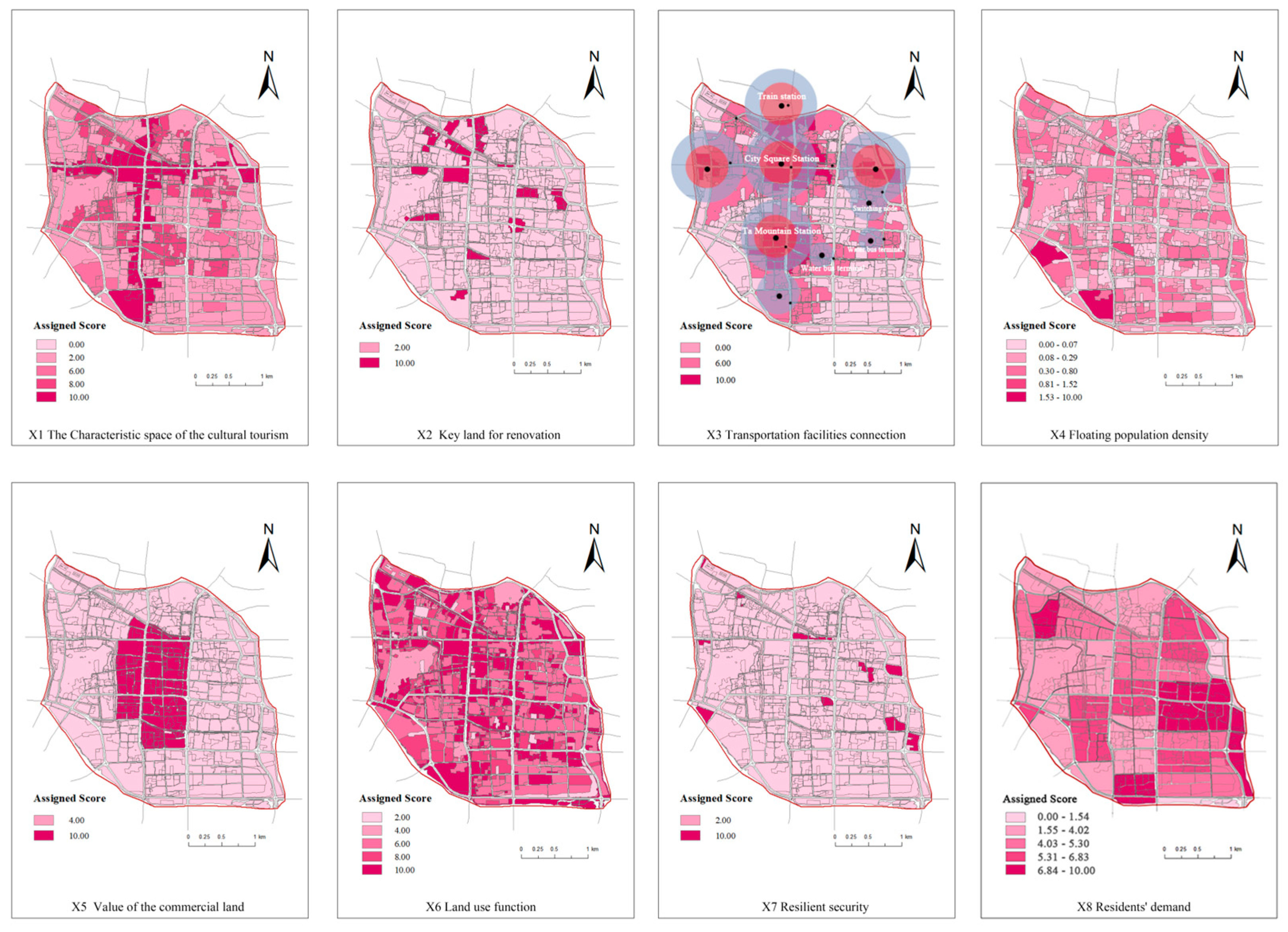
5.1. Single-Factor Evaluation
5.2. The Evaluation of USD Demand Levels and Suitability
5.3. Identification of Areas with USDP
6. Optimization Strategies
6.1. Optimization Strategies for Utilizing Developed Underground Spaces
6.2. Optimization Strategies for High-Potential Underground Spaces
7. Conclusions
Author Contributions
Funding
Data Availability Statement
Acknowledgments
Conflicts of Interest
Abbreviations
| USDP | Underground Space Development Potential |
| USD | Underground Space Development |
| SCA | Shaoxing Ancient City |
References
- Zheng, H.W.; Shen, G.Q.; Wang, H. A review of recent studies on sustainable urban renewal. Habitat Int. 2014, 41, 272–279. [Google Scholar] [CrossRef]
- Yi, Z.Y.; Liu, G.W.; Lang, W.; Shrestha, A.; Martek, I. Strategic Approaches to Sustainable Urban Renewal in Developing Countries: A Case Study of Shenzhen, Chinal. Sustainability 2017, 9, 1460. [Google Scholar] [CrossRef]
- Huang, R. Improvement of the Vitality of Public Space under the Background of Urban Renewal. J. Landsc. Res. 2024, 5, 38–40. [Google Scholar]
- Wu, L.Y. The Old City of Beijing and Juer Hutong Neighbourhood; China Architecture & Building Press: Beijing, China, 1994. [Google Scholar]
- Wang, X.Y. Inheriting the Context and Revitalizing the Environment: An Exploration of the Organic Combination of Cultural Context Inheritance and Urban Renewal—Taking the Historical and Cultural Block of Nanshijie and Ciguling in the Ancient City of Ganzhou as an Example; Urban Planning Society of China: Wuhan, China, 2023. [Google Scholar]
- Zhou, M.W. Research on the Organic Renewal Strategy of Suzhou Ancient City from the Perspective of Park City; Urban Planning Society of China: Wuhan, China, 2023. [Google Scholar]
- Xue, H.W. Research on Renewal and Reconstruction of Taizhou Ancient District Under the Concept of “Organic Renewal”. Master’s Thesis, Yunnan Agricultural University, Kunming, China, 2023. [Google Scholar]
- Gu, S.M.; Li, J.Q.; Wang, M.H.; Ma, H. Post-Renewal Evaluation of an Urbanized Village with Cultural Resources Based on Multi Public Satisfaction: A Case Study of Nantou Ancient City in Shenzhen. Land 2023, 12, 211. [Google Scholar] [CrossRef]
- Wang, J.Q.; Shu, D.Y. The Current Situation, Protection and Renewal Strategy about Old Jingzhou: The Update of Dongdi Street in the Old South Gate for Example. South Archit. 2013, 1, 36–40. [Google Scholar]
- Klingmann, A. Re-scripting Riyadh’s Historical Downtown as a Global Destination: A Sustainable Model? J. Place Manag. Dev. 2022, 15, 93–111. [Google Scholar] [CrossRef]
- Cheng, G.H.; Su, J.W.; Li, C.; Yang, Y.; Zhao, M.H.; Wang, R. Strategic Thinking of Urban Underground Space Exploration and Safe Utilization. East China Geol. 2019, 3, 1–8. [Google Scholar]
- Chen, Z.L.; Chen, J.Y.; Liu, C.H.; Zhang, Z.F. Present Status and Development Trends of Underground Space in Chinese Cities: Evaluation and Analysis. Tunn. Undergr. Space Technol. 2018, 71, 253–270. [Google Scholar] [CrossRef]
- Chicago AreaTransportation Study. The Chicago Area Rail System-1976 to 2006. Available online: https://www.catsmpo.com/ (accessed on 5 September 2024).
- Tricoire, J. Le Metro de Paris:1899–1911: Images de la Construction; Paris-Musées-RATP: Paris, France, 1999. [Google Scholar]
- Valdenebro, J.; Gimena, F.N. Urban Utility Tunnels as a Long-term Solution for the Sustainable Revitalization of Historic Centres: The Case Study of Pamplona-Spain. Tunn. Undergr. Space Technol. 2018, 81, 228–236. [Google Scholar] [CrossRef]
- Yu, W.F. Research on the Protection of the Historical and Cultural City of Suzhou. Ind. Sci. Trib. 2021, 20, 200–203. [Google Scholar]
- Zeng, R.S.; Shen, Z.W.; Luo, J. Post-occupancy Evaluation of User Satisfaction: Case Studies of 10 Urban Underground Complexes in China. Tunn. Undergr. Space Technol. 2024, 143, 105500. [Google Scholar] [CrossRef]
- Zhang, L.; Shu, Y.; Lu, S. Planning Theory and Key Technology for the Development of Underground Spaces in Urban Historic Conservation Area. Urban Dev. Stud. 2014, 21, 79–83. [Google Scholar]
- Tong, L.X.; Zhu, W.J. The Evaluation and Develop Planning of Urban Underground Space Resources; Architecture & Building Press: Beijing, China, 2009; pp. 8–9. [Google Scholar]
- Jia, S.P.; Li, W.P. Review of Assessment of Urban Underground Space Resources. Chin. J. Undergr. Space Eng. 2008, 3, 397–401. [Google Scholar]
- Liu, K.; Peng, J.; Peng, F.L. Evaluation Model for the Suitability of Underground Space Resources Exploitation and Utilization. Chin. J. Undergr. Space Eng. 2011, 7, 219–231. [Google Scholar]
- Long, R.; Zhang, F.W.; Luan, S.; Li, W.X. Evaluation of Urban Underground Space of Guangzhou City: Its Development and Utilization. Northwest. Geol. 2020, 53, 194–206. [Google Scholar]
- Li, K.Y.; Shao, J.H.; Lin, R.Z.; Liu, G.; Zhang, Y.; Yang, M.G. The Research on the Evaluation Framework and Application of Urban Three-dimensional (Aboveground and Underground) Regeneration Sensitivity—Taking Kunshan Old City in China as an example. Tunn. Undergr. Space Technol. 2025, 159, 106428. [Google Scholar] [CrossRef]
- Lin, M.N. Evaluation of Urban Underground Space Development Potential in Kunming City. Master’s Thesis, Kunming University of Science and Technology, Kunming, China, 2019. [Google Scholar]
- Li, K.; Chen, J.W.; Xu, F.F.; He, Y.; Li, J. Evaluation Model of Comprehensive Potential of Underground Space Development in Coastal Cities. Chin. J. Undergr. Space Eng. 2023, 19, 1412–1421. [Google Scholar]
- Hong, X.C.; Zhang, J.X.; Chen, L.; Liu, C.J.; Cai, H. Research on the Development Model and Strategy of Underground Space in Ancient Cities Based on Organic Renewal Theory. China Anc. City 2024, 38, 48–56. [Google Scholar]
- Sterling, R.L.; Nelson, S.H. Planning the Development of Underground Space. Undergr. Space 1982, 7, 86–103. [Google Scholar]
- Youssef, A.M.; Pradhan, B.; Tarabees, E. Integrated Evaluation of Urban Development Suitability Based on Remote Sensing and GIS Techniques: Contribution from the Analytic Hierarchy Process. Arab. J. Geosci. 2011, 4, 463–473. [Google Scholar] [CrossRef]
- Doyle, M.R. From Hydro/geology to the Streetscape: Evaluating Urban Underground Resource Potential. Tunn. Undergr. Space Technol. Inc. Trenchless Technol. Res. 2015, 55, 83–95. [Google Scholar] [CrossRef]
- Tan, F.; Wang, J.; Jiao, Y.Y.; Ma, B.C. Current Situation and Development of Urban Underground Space Suitability Evaluation. Earth Sci. 2021, 46, 1896–1908. [Google Scholar]
- Man, Z. Research on Demand Evaluation and Development Strategy of Guangzhou Underground Space Based on Points of Interest. Master’s Thesis, Jinan University, Jinan, China, 2020. [Google Scholar]
- Zheng, Q. A Study on City Underground Space Development Potential—Taking Tianfu New Area as an Example. Master’s Thesis, Sichuan Agricultural University, Chengdu, China, 2013. [Google Scholar]
- Zhang, P.; Xiao, Y. Suitability Evaluation Method for Historic Relic Underground Space Resource Development. J. Army Eng. Univ. PLA 2014, 15, 203–208. [Google Scholar]
- Pang, J.; Liu, K.; Zheng, F.T.; Li, X.J.; Peng, F.L. Evaluation for the Suitability of Underground Space Exploitation and Utilization Based on AHP. Chin. J. Undergr. Space Eng. 2010, 6, 688–694. [Google Scholar]
- Wang, X.; Huang, X.J.; Zhen, F.; Zhong, T. Evaluation on Development Potential of Urban Underground Space Resource: Multi-level Grey Approach. J. Tongji Univ. 2009, 37, 1122–1127. [Google Scholar]
- Zhang, W.; Qu, W.W. Research on the Development Potential of Urban Underground Space. Constr. Econ. 2010, 6, 116–118. [Google Scholar]
- Hao, M.; Ren, W.Y.; Xia, W.Q.; Fu, J.; Zhu, H.; Sun, P.; Wang, K.; Xu, M. Suitability Evaluation of Urban Underground Space Development: A Case Study of Qingdao City. Appl. Sci. 2024, 14, 6617. [Google Scholar] [CrossRef]
- Wang, Z.L. Study on Implementability Evaluation of Underground Space in Historical and Cultural Blocks Based on GIS: A Case Study of Tianjin Downtown Area. Master’s Thesis, Tianjin University, Tianjin, China, 2019. [Google Scholar]
- Zhu, Y.G.; Zhao, J.W.; Huang, Z.Y. Evaluation of Underground Space Development in Historical District Based on AHP. Chin. J. Undergr. Space Eng. 2018, 14, 1437–1444, 1465. [Google Scholar]
- Li, X.Z.; Zhao, X.B.; Wu, W.B.; Cao, L.; Li, H.Q. Evaluation of Geo-environmental Suitability for the Development of Underground Space in Suzhou. In Proceedings of the 13th World Conference of Associated-Research-Centers-for-the-Urban-Underground-Space (ACUUS), Singapore, 7–9 November 2012. [Google Scholar]
- Xie, Z.Q.; Hou, Z.Q. Evaluation of Carrying Capacity for Urban Underground Space Planning and Development; Science Press: Beijing, China, 2022; pp. 65–69. [Google Scholar]
- Zhao, Y.T.; Wu, K.J.; Shi, X.D.; Lin, L.Q. Evaluation and Planning of Underground Space Resources in Highly-Built Areas From Perspective of Multi-`Dimensional Value: A Case Study of Core Area in Beijing, China. Tunn. Constr. 2025, 45, 1180–1191. [Google Scholar]
- Wu, X.Z. Study on Assessment of Urban Underground Space Resources in Wuhu City. Chin. J. Undergr. Space Eng. 2021, 17, 9–18+40. [Google Scholar]
- Chen, S.; Li, Q.H.; Zhang, Y.P.; Song, G.Q. Value Differentiation Characteristics and Evaluation Methods of Urban Underground Space Development Considering Geological Factors—Taking Jiangdong New District of Haikou City as an Example. Saf. Environ. Eng. 2022, 29, 232–243. [Google Scholar]
- You, Y.C.; Jiang, Y.X. Value Characteristics and Evaluation Methods of Urban Underground Space Development with Geological Factors as the Core. Value Eng. 2025, 44, 63–65. [Google Scholar]
- Wu, W.B. Research on The Evaluation for Underground Space Resource in Suzhou Urban Planning Area. Master’s Thesis, Nanjing University, Nanjing, China, 2012. [Google Scholar]
- Zhang, P.; Chen, Z.L.; Huang, O.L.; Wang, H. Historical District Preservation and Underground Space Development. Planners 2011, 10, 99. [Google Scholar]
- Qi, X.X.; Li, J.C. Evaluation on Demand Degree of Urban Underground Space based on the POI Data: A Case Study in Jinan City. China Land Sci. 2018, 32, 36–44. [Google Scholar]
- Liu, J.N.; Liu, Y.F.; Wang, X.; Zhang, Y.; An, R. Evaluation of Development and Utilization Potential of Underground Space. Sci. Surv. Mapp. 2021, 45, 202–211. [Google Scholar]
- Zou, L. Guide to Methods for Evaluating Underground Space Resources and Forecasting Demand; Architecture & Building Press: Beijing, China, 2017; pp. 9–17. [Google Scholar]
- Wan, H.B. The Strategy Research on Urban Underground Space in High-Density Area. Master’s Thesis, Tianjin University, Tianjin, China, 2013. [Google Scholar]
- Li, H.C.; Cha, P.S.; Kang, B. Evaluation Index System of Urban Underground Space: A Case Study of Nantong City. J. Hefei Univ. Technol. 2020, 34, 113–120. [Google Scholar]
- Qiao, Y.K.; Peng, F.L.; Wang, Y. Monetary valuation of urban underground space: A critical issue for the decision—making of urban underground space development. Land Use Policy 2017, 69, 12–24. [Google Scholar]


| Data | Spatial Resolution | Acquisition Date | Data Sources |
|---|---|---|---|
| Land use data | Vector Data | 2022 | Natural Resources and Planning Bureau of Shaoxing City |
| Engineering hydrological | Raster Data (5 m × 5 m) | 2020 | |
| Geological data | Raster Data (5 m × 5 m) | 2020 | |
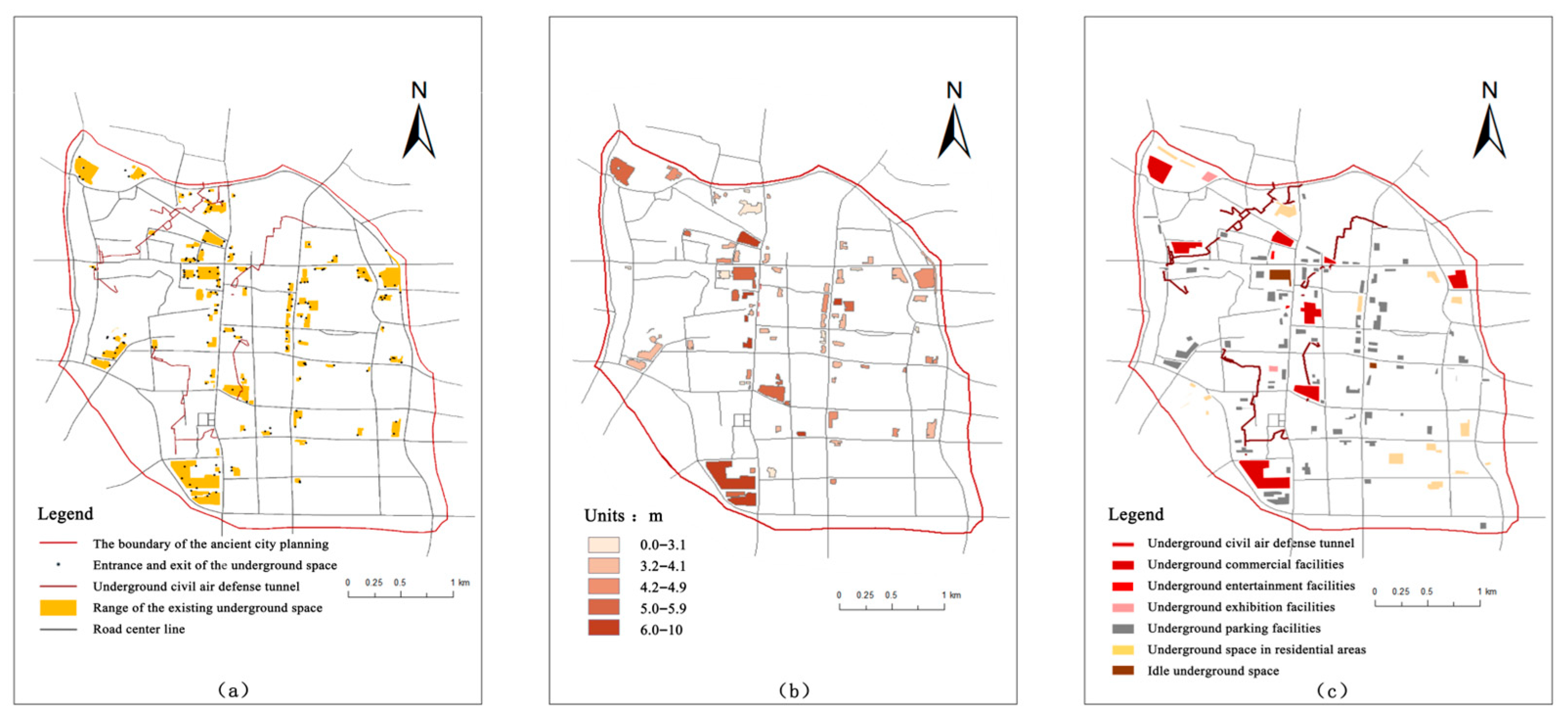
| Current underground space data | Vector Data | 2022 | |
| Building boundary data | Vector Data | 2022 | |
| Road network data | Vector Data | 2022 |
| Location | Components |
|---|---|
| Key development areas | Protection and Utilization of Ancient Cities “14th Five-Year Plan”: Key renewal areas proposed in the planning and ancient city renewal action plan |
| Ancient city functional axis | Key location impact (subway line intersections), the main development axis of the ancient city |
| Ancient City Cultural Ring | The core cultural display belt of the ancient city (including historical and cultural blocks, historic buildings, and other special spaces) |
| Other characteristic elements | The ancient city’s characteristic elements outside the ring |
| Area without characteristic elements | Other urban areas |
| Nature of Land Use | Ground Land Use Function | Corresponding Underground Functional Facilities | Development Value |
|---|---|---|---|
| B | Commercial service facility land use | An underground complex combining a commercial business center and a transportation hub, providing three-dimensional transportation | High |
| A | Cultural facility land use | Underground exhibitions, underground collections, or underground cultural activities | High |
| A1 | Administrative office space | Underground administration, underground parking system | Higher |
| S | Land for road and traffic facilities | Rail transit, integrated pipe gallery, or underground public service facilities combining commercial and transportation functions | Higher |
| G | Green spaces and squares | Underground parking or semi-underground public space for public interaction | Higher |
| A3 | Education and scientific research land use | Underground pick-up space | Medium to high |
| A5 | Medical and health land use | Underground medical space | Medium to high |
| R | Residential land use | Underground parking system, underground infrastructure, or innovative underground neighborhood space, supporting facilities for community life circle | Medium |
| U | Municipal public facility | Underground municipal utilities or integrated pipe gallery | Medium |
| W | Logistics and warehousing land use | Underground warehouse or underground logistics system | Lower |
| M | Industrial land use | Underground warehouses or special industrial workshops that require underground environments | Lower |
| Category | Ancient City Protection Factors Related to Underground Space Construction |
|---|---|
| points (Cultural relics, ancient bridges, ancient trees) | National cultural relics protection units (buffer zone 30 m) |
| Provincial cultural relics protection unit (buffer zone 20 m) | |
| Municipal cultural relics protection units and sites (buffer zone 10 m) | |
| Ancient bridges, ancient trees, and famous trees (buffer zone 10 m) | |
| Underground archaeological sites | |
| areas (Protection area, construction control area, and landscape control area) | Core protection area of historical and cultural blocks; Grand Canal National Heritage Protection and Control Area |
| Historical and cultural block construction control area | |
| Historical and cultural district style coordination area |
| Target Layer | Criteria Layers and Weights | Evaluation Indicators | Evaluation | Relative Weight |
|---|---|---|---|---|
| Demand factor indicator | Spatial quality improvement (0.3) | Ancient city cultural tourism characteristic space (X1) | Characteristic spatial structure and potential underground cultural tourism service connection points | 0.12 |
| Key land for renovation (X2) | Idle and inefficient land use, renovation, and high-rise relocation | 0.18 | ||
| Transportation efficiency enhancement (0.2) | Transportation facility connection (X3) | Public transport transfer points | 0.2 | |
| Spatial value increment (0.3) | Floating population density (X4) | Tencent Yi Travel Data | 0.1 | |
| Land value (X5) | The benchmark land price for commercial and service land is high | 0.1 | ||
| Current land use function (X6) | Developing the value of underground space | 0.1 | ||
| Functional deficiency remedying (0.2) | Resilient security (X7) | Waterlogging points and flood control and drainage demand points | 0.1 | |
| Residents’ demands (X8) | High permanent population density and lack of facilities | 0.1 | ||
| Suitability factor indicator | Historical preservation constraints (0.265) | Historic preservation resources (Y1) | Sum of the points and areas of historical and cultural resources within the plot | 0.265 |
| Ecologically sensitive constraints (0.13) | Ecologically sensitive areas (Y2) | High ecological protection level and ecological service capacity | 0.13 | |
| Engineering conditions (0.3) | Rock and soil bearing capacity (Y3) | Poor suitability for engineering construction and low bearing capacity | 0.095 | |
| Geological disasters (Y4) | Area highly prone to disasters | 0.1 | ||
| Single well water yield (Y5) | Unfavorable hydrological conditions | 0.105 | ||
| Engineering activities (0.305) | Building height (Y6) | Basic occupation area | 0.108 | |
| Building structure (Y7) | Areas with high vulnerability of surface building structures | 0.1 | ||
| Status of underground space (Y8) | Underground built areas | 0.097 |
| Indicator Name | Evaluation Criteria | ||||
|---|---|---|---|---|---|
| 2 | 4 | 6 | 8 | 10 | |
| X1 | None | - | Characteristic space outside the ring belt | Core cultural circle | Urban development axis |
| X2 | Other areas | - | - | - | Belonging |
| X3 | Other areas | - | Transportation hub within 500 m | - | Transportation hub within 300 m |
| X4 | Min-max standardization | ||||
| X5 | Min-max standardization | ||||
| X6 | Waters | Warehousing and industrial land | Municipal facilities, residential land | Public administration and public service land, land for transportation facilities | Commercial and service facilities, cultural facilities, green plaza land |
| X7 | Other areas | - | - | - | Areas prone to disasters such as rainstorms and floods |
| X8 | Min-max standardization | ||||
| Y1 1 | Min-max standardization | ||||
| Y2 | - | Parkland | - | Ecological and protective green space | Waters |
| Y3 | Good suitability | - | - | - | Poor suitability |
| Y4 | Areas not prone to land subsidence | - | - | Land subsidence prone areas | - |
| Y5 | <100 | [100, 400) | [400, 700) | [700, 1000) | [1000–3000) |
| Y6 | Min-max standardization | ||||
| Y7 | Concrete structure | Hybrid structure | - | Brick structure | Wooden structure |
| Y8 | No underground space | - | - | Single layer | Two floors and above |
| Suitability | I (High) | II (Low) | |
|---|---|---|---|
| Demand Level | |||
| I (High) | Great development potential | Average development potential | |
| II (Low) | Average development potential | Low development potential | |
| Potential Area | Combination Type | Development Priorities/Feasibility Level | Area (m2) | Land Area Ratio (%) |
|---|---|---|---|---|
| High-potential area | High demand level and high suitability | Priority and key development area | 1,489,000 | 16.38% |
| General-potential area | High demand level and low suitability | Coordinated development area | 840,000 | 9.24% |
| Low demand level and high suitability | Strategic reserve | 2,630,000 | 28.95% | |
| Low-potential area | Low demand level and low suitability | Not suitable for development | 2,215,600 | 24.37% |
| Prohibited development area | Cultural relics and historic sites in an ecological bottom-line area | Development activities generally not permitted | 1,915,000 | 21.06% |
| USDP | Status of Use | ||
|---|---|---|---|
| I—Perfect Functions and Construction, High Current Level of Utilization | II—Functions and Environment Need to Be Partially Improved, General Current Level of Utilization | III—Idle or Waiting for Update and Reconstruction, Low Current Level of Utilization | |
| A high | A I | A II | A III |
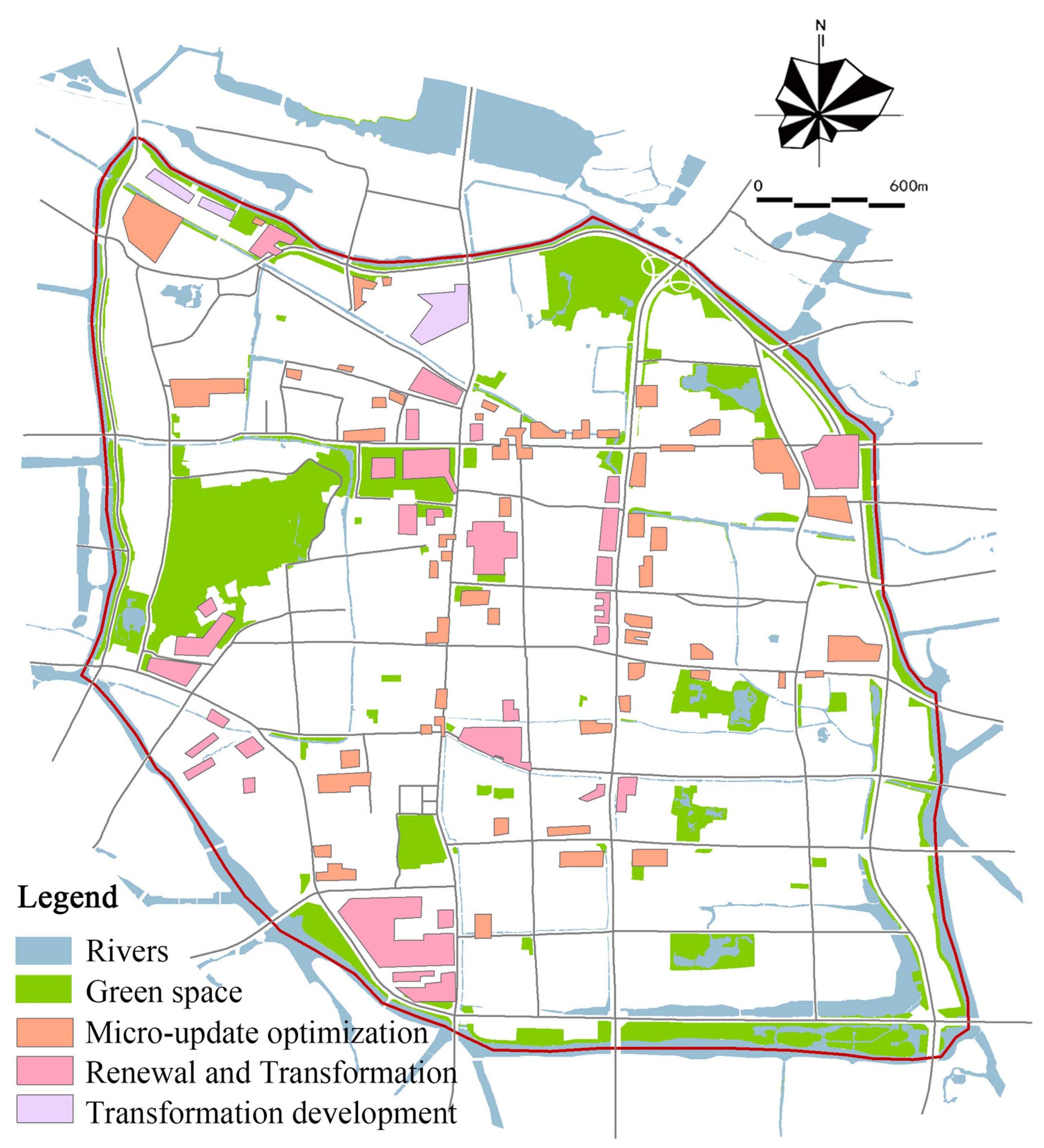
| Micro-update optimization | Renewal and Transformation | Renewal and Transformation | |
| B middle | B I | B II | B III |
| Micro-update optimization | Micro-update optimization | Renovation | |
| C Low | C I | C II | C III |
| Micro-update optimization | Transformation development | Transformation development | |
| Development Potential Evaluation | Optimized the Use of Partitions | Zoning Development Model | Segmentation | Strategies to Optimize Utilization |
|---|---|---|---|---|
| Developed area | Underground space renovation area | Renovation and reconstruction, micro-renovation and optimization, supplementation of disaster prevention facilities, etc. | Developed underground space (such as old residential areas, etc.). | Functional upgrading and transformation, enhancing interconnection, underground infrastructure, supplementing living facilities, etc. |
| Developed civil air defense projects | Combining peacetime and wartime, coordinating with urban functions | |||
| High-potential area | Priority and key development areas | Explore pilot areas for USD, such as rail transit station areas and plots of land that have been renovated into commercial service industries, to achieve symbiosis between aboveground and underground development. | Rail transit stations surrounding | Improve interconnection and integrated development |
| Renovation areas | Develop underground space in conjunction with urban renewal | |||
| Historical and Cultural Tourism Portal | Place tourism distribution function and showcase the image of the portal | |||
| Traffic Parking Complex Area | Relieve traffic problems and add parking facilities | |||
| General-potential area | Coordinated development area, strategic reserved area | Aboveground and underground integration, strategic reserve | Concentrated contiguous area | Address the shortcomings on the ground and make strategic reservations |
| Low-potential area | Not suitable for development | Protection and control | Engineering hydrogeology and other restricted areas | Safety risks must be eliminated during development |
| Prohibited development area | Prohibited development area | Protection and control | Ecological and historical protection areas | Strictly control USD and link it with relevant planning and control requirements |
Disclaimer/Publisher’s Note: The statements, opinions and data contained in all publications are solely those of the individual author(s) and contributor(s) and not of MDPI and/or the editor(s). MDPI and/or the editor(s) disclaim responsibility for any injury to people or property resulting from any ideas, methods, instructions or products referred to in the content. |
© 2025 by the authors. Published by MDPI on behalf of the International Society for Photogrammetry and Remote Sensing. Licensee MDPI, Basel, Switzerland. This article is an open access article distributed under the terms and conditions of the Creative Commons Attribution (CC BY) license (https://creativecommons.org/licenses/by/4.0/).
Share and Cite
Chen, Q.; Qi, Y.; Xu, G.; Chen, X.; Zhang, X.; Li, H. Evaluation of Underground Space Resources in Ancient Cities from the Perspective of Organic Renewal: A Case Study of Shaoxing Ancient City. ISPRS Int. J. Geo-Inf. 2025, 14, 384. https://doi.org/10.3390/ijgi14100384
Chen Q, Qi Y, Xu G, Chen X, Zhang X, Li H. Evaluation of Underground Space Resources in Ancient Cities from the Perspective of Organic Renewal: A Case Study of Shaoxing Ancient City. ISPRS International Journal of Geo-Information. 2025; 14(10):384. https://doi.org/10.3390/ijgi14100384
Chicago/Turabian StyleChen, Qiuxiao, Yiduo Qi, Guanjie Xu, Xiuxiu Chen, Xiaoyi Zhang, and Hongbo Li. 2025. "Evaluation of Underground Space Resources in Ancient Cities from the Perspective of Organic Renewal: A Case Study of Shaoxing Ancient City" ISPRS International Journal of Geo-Information 14, no. 10: 384. https://doi.org/10.3390/ijgi14100384
APA StyleChen, Q., Qi, Y., Xu, G., Chen, X., Zhang, X., & Li, H. (2025). Evaluation of Underground Space Resources in Ancient Cities from the Perspective of Organic Renewal: A Case Study of Shaoxing Ancient City. ISPRS International Journal of Geo-Information, 14(10), 384. https://doi.org/10.3390/ijgi14100384


