Abstract
Protected areas (PAs) help in strategies for maintaining biodiversity and inhibiting deforestation of the Amazon rainforest. However, there are few studies that evaluate the effectiveness of lands protected by states (or federation units). Our goal was to compare land use change over 35 years in state-level PAs with another area of protection, both in the Amazon of the Maranhão state, Brazil. We employed remote sensing techniques, the geographic information system (GIS), and statistical analysis with the use of analyses of covariance (ANCOVAS) to analyze the presence of the classes of land use and change in the PA. The results indicate that the state PAs were effective in preserving forest cover and decelerating grazing. The implications of the results are discussed in the context of supporting public policies at the state level for the protection of the Amazon.
1. Introduction
The Amazon is the largest tropical forest in the world, a world heritage site, home to a rich biodiversity of flora/fauna, and contains an exuberant number of rivers [1,2,3]. The conservation of the Amazon forest has been the topic of debate worldwide due to its extension, its ecological relevance, and the current conjuncture of conflicts motivated by deforestation. Unfortunately, research has been showing that the Amazon is at risk due to the high degree of deforestation [4,5,6,7].
The factors associated with deforestation in the Amazon are diverse, such as the increasing human population [8] and forest fires [9,10,11,12]. Studies indicate that the consequences of deforestation result in increased disease [13,14], climate change [15,16], air pollution [17,18], water pollution [19,20], clandestine road opening [21,22,23], illegal expansion of agriculture areas [24,25], expansion of cattle ranching [26,27], threats to Indigenous lands [28,29], and threats to protected areas (PAs) [30,31,32], among others.
According to a study [33], there has been a governmental effort to adapt the productive and economic extractive activities to the protection of nature for a long time. However, the increase in deforestation in the Amazon forest has been detected in several areas, including the so-called protected areas (PAs), such as Indigenous lands (ILs) and conservation units [34,35], which were created with the intention of protecting socio-biodiversity and conserving the vegetation that they still have inside. According to Assis et al. [36], conservation units can assist in territorial and environmental management strategies of watersheds to preserve the natural resources of the Amazon rainforest. Several authors also emphasize the importance of PAs in the Amazon and their relationship with climate [37,38,39].
As a result, a great challenge has emerged among public managers, non-governmental organizations (NGOs), and universities to seek sustainable alternatives for these areas in the Amazon biome. Several studies have shown how effective PAs are in preserving forest areas in the Brazilian Amazon [40,41,42]. For example, Jesus and Catojo [30] analyzed the dynamics of deforestation (clear-cutting) in a set of PAs in the northern Amazon biome. The results revealed that PAs are efficient tools in conserving natural ecosystems, with maintenance of the main forest cover. In addition, they found that an important reason for clear-cutting the forest was the establishment of pastures for cattle ranching.
Given all the issues raised, we have identified that few studies have evaluated the effectiveness of state-level PAs in Brazil. Therefore, this research seeks to fill this gap by conducting an assessment of land use change in two areas contained within the Brazilian Amazon, the Baixo Munim region, which contains the state PA Upaon-Açu/Miritiba/Alto Preguiças that protects about 91.3% of the region in comparison with the Pindaré region that has the PA Baixada Maranhense (state protection) and the Gurupi Biological Reserve (federal protection), which together ensure the protection of less than 20% of the region. One of them has a legal state protection status and the other has little protection. The evaluation was carried out with remote sensing techniques and statistical analysis with the use of the geographic information system (GIS) at a time scale of 35 years. The paper is relevant in presenting two planning regions contained in the Brazilian Amazon, which have differentiated protection statuses, to the scientific community. By using data from the MapBiomas Brasil platform, which is consistently validated and has a high level of accuracy, the present results help to prove the importance of PAs for the Amazon.
The novelty of this paper is the evaluation of environmental protection areas in two distinct regions inside the Brazilian Amazon through a methodological approach that combines remote sensing and statistical technique of analysis of covariance (ANCOVA), which makes it possible to measure land use changes during different decades. In this way, this approach permits a more precise assessment of PAs’ effectiveness in reducing deforestation.
2. Materials and Methods
2.1. Study Area
The study area comprises two planning regions located in the Northeast of the Brazilian Amazon: Baixo Munim (91.3% protected areas) and Pindaré (less than 20% protected areas). The Baixo Munim region is in the north of the state of Maranhão, while the Pindaré region is in the mid-west, both inserted in the Amazon biome (Figure 1). Their geographical positions contribute to them presenting climatic peculiarities due to the strong action of the humid Equatorial Forest [43].
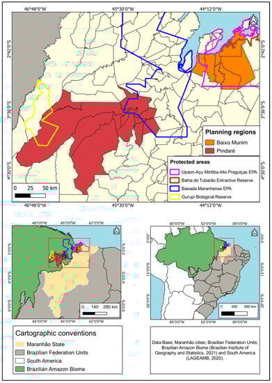
Figure 1.
Location of the study area.
Table 1 shows the PAs present in the Baixo Munim and Pindaré regions, highlighting the area in km2, the level of protection, and their respective municipalities.

Table 1.
Protection areas of each region in km2.
2.2. Land Use Maps
The vector data of limits were collected from the Brazilian Institute of Geography and Statistics (IBGE), and the raster data originated from the Landsat Satellite family with spatial resolution of 30 m (TM, ETM+ and OLI). The mosaics of images from each year were classified automatically with the random forest method. The multitemporal mosaics of images for the years 1985, 1995, 2005, 2015, and 2019 were downloaded by the Google Earth Engine (GEE) Toolkit plugin associated with the MapBiomas Brazil project, which generated five classification mosaics for the two regions of interest. The accuracy of the satellite images is validated based on the evaluation of a sample of pixels, which we call the reference database, consisting of 75,000 samples. The number of pixels in the reference database was predetermined by statistical sampling techniques. In each year, each pixel in the reference database was evaluated by technicians trained in the visual interpretation of Landsat images. The MAPBIOMAS Brasil collection 5 has an overall accuracy of 97.6% and an area disagreement of up to 1.2%. In each year, the accuracy analysis is performed by cross-tabulating the sample frequencies of the mapped classes. This information is available at https://mapbiomas.org/analise-de-acuracia(accessed on 15 December 2022) [44].
Subsequently, the downloaded information was also handled with the QGIS software. For making and analyzing the trends, the attribute tables of the raster images for the years 1985, 1995, 2005, 2015, and 2019 were extracted.
In the QGIS software, we used the item “Report single value raster layer” to acquire the attribute tables containing the codes of the use and cover classes, the pixel number and each pixel’s area. Using this table, the total area of all the land uses of the two planning regions could be calculated, determining the total area values, whereupon, using the auto-sum feature and incorporating the exported attribute table, the conversion was performed. Thus, using the conversion value “0.0009” (which is the conversion factor of the area of a 1 pixel into km2) it was multiplied by the pixel count to obtain the area of each class. The expression used was:
A = X · 0.0009
Which represents:
A = the area value for each class in square kilometers;
X = the pixel count for each use or cover type;
0.0009 = the conversion factor from pixel area to km².
The percentages (%) of the typologies were obtained by dividing the area of each use or cover in km² by the total area of uses and covers and the result was multiplied by 100. Finally, the percentage difference between one year and another, within the time scale, was calculated. Figure 2 presents the procedure adopted in this step of using the MapBiomas platform and the GIS.
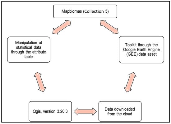
Figure 2.
Procedures adopted during the survey of land use percentages.
2.3. Statistical Analysis
To analyze the effect of the presence of a PA on land use change, analyses of covariance (ANCOVAS) were performed. The percentage information of each land use class was obtained through the attribute tables extracted from the satellite images, where a statistical calculation for area was performed. This procedure was described in the previous topic, the rate of land use change was calculated, given by the formula Ri = Ac − Al. Where Ri is the rate of land use change for year i, Ac is the percentage of area occupied by the class in the current year, and Al is the percentage of area occupied by the class in the last year measured. Subsequently, for each land use class, an ANCOVA was performed, in which years were the covariate, the presence of regions was the categorical variable, and land use change rates were the dependent variables. To relate the changes in land uses to land use classes over the years, correlation matrices were constructed for each of the study areas using the areas of each land use class using the Pearson correlation coefficient.
3. Results
3.1. Analysis of Land Use Classes
In the Baixo Munim area (protected region), the data indicated that the natural formation class remained stable in the central-eastern portion until 1995; when this class began to grow in 2005, it overlapped with the areas of more spaced formation, such as the savannah formation, which were concentrated more towards the west. In 2015, the forest formation, savannah, and mangroves declined at the expense of the increase in classes such as the campestral formation and rivers, lakes, and oceans formation, which now had the same growth trend as the forest formations, and there was a decline in the savannah formation and mangroves in the year 2019. In this same year, small areas for temporary crops, such as soybeans (Glycine max), appeared, but not as evident in terms of percentages. Figure 3 shows the types of land use in the Baixo Munim region between the years 1985 and 2019, as well as their respective percentages.
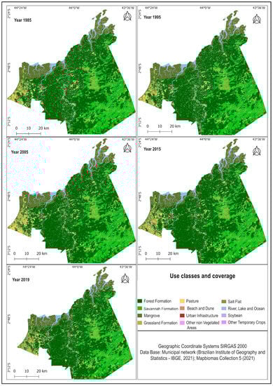
Figure 3.
Map of land use in the Baixo Munim region.
In relation to the Pindaré area (Figure 4), the results revealed that this region presented a high degree of degradation of its native vegetation cover. This is noticeable because the forest formation that existed for the most part in 1985 became pastureland in the decades of 1995 and 2005. In 2005, it was observed that the region had already reached a degree of degradation from which there is no return to its natural landscape. Finally, in 2015 and 2019, the region was taken almost entirely for pasture and other uses, such as urban infrastructure and other temporary crops and soybeans (Glycine max).
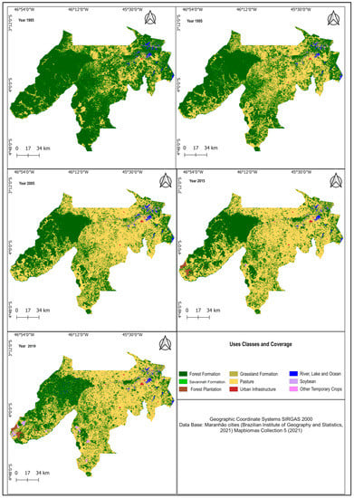
Figure 4.
Map of land use in the Pindaré region.
Through the analysis of land use change between the Baixo Munim and Pindaré regions, it is possible to observe that the presence of PAs is essential for the maintenance of existing native vegetation. The fact that the Baixo Munim region has PAs throughout its territory was fundamental for the maintenance of the forest class and the control of the advancement of other anthropic classes, such as pasture. On the other hand, the Pindaré region presented an advancement in the pastureland class and a reduction in the forest class during all the decades studied; this characteristic is attributed to the low presence of PAs in its territory, besides showing the effectiveness of the Gurupi Biological Reserve, which alone is able to concentrate a significant portion of the existing native vegetation in the region.
3.2. ANCOVA and Correlation Matrix
Our results indicate that over the years, there was a reduction in the rate of land use change of the forest class in the Pindaré region. On the other hand, in the Baixo Munim region, the rate of land use change of the forest class remained stable throughout the investigated period (Figure 5a). In the Pindaré region, a decrease in the rate of the land use change of the pasture class was also observed (Figure 5b). In the Baixo Munin region, the rate of the land use change of the pasture class was low and stable throughout the entire period (Figure 6). The other land use classes did not change significantly (Supplementary Materials). In summary, it can be observed that deforestation in the Baixo Munim region was not very significant. The Pindaré region was highly altered by anthropic uses until 1995, and since then the levels of deforestation and opening of areas for pasture have decreased because it has little native forest.
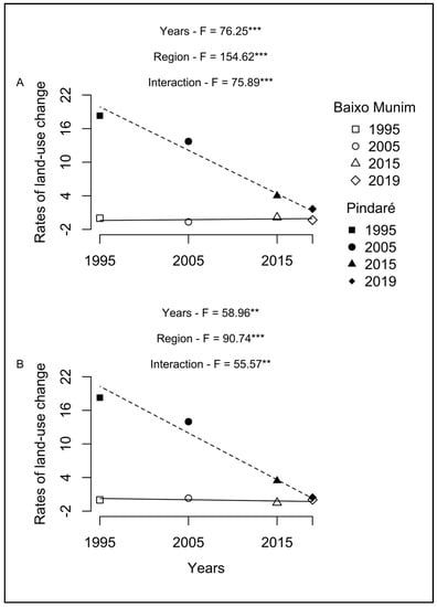
Figure 5.
ANCOVA results: (A) Forests; (B) Pastures. * for p < 0.05, ** for p < 0.01 and *** for p < 0.001.
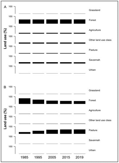
Figure 6.
Areas in percentages for each land use class: (A) Baixo Munim; (B) Pindaré. * for p < 0.05, ** for p < 0.01 and *** for p < 0.001.
In the Baixo Munim region, there was a negative correlation between the forest area and the savannah (Table 2). We also observed a negative correlation between the savannah area and the urban area. However, a positive correlation was observed between the grassland area and the urban area. For the Pindaré region, the forest area was negatively related to the pasture and urban area (Table 2). The savannah area was also negatively related to the pasture and urban area. On the other hand, the forest area was positively related to the savannah area. The pasture area was also positively related to the urban area.
Table 2.
Correlation matrix between land use classes over the years for each study area. * for p < 0.05, ** for p < 0.01 and *** for p < 0.001.
Furthermore, the results revealed significant differences in the correlations between land use classes in the two regions studied. In the Baixo Munim region, a negative correlation was observed between the forest area and the savannah, as well as a negative correlation between the savannah and the urban area. On the other hand, the pasture area was positively correlated with the urban area in the region. In the Pindaré region, on the other hand, the forest area was negatively related to the pasture area and the urban area, while the savannah area was also negatively related to the pasture area and the urban area. On the other hand, the forest area was positively correlated with the savannah area, and the grassland area was positively correlated with the urban area. These results highlight the importance of understanding the different interactions between land use classes in each region in order to implement effective policies for the conservation and sustainable management of the landscape.
4. Discussion
Our results revealed that land use dynamics are more homogeneous across time series in the Amazon region that has state-protected status than those without protection. According to Pack et al. [45], protected areas (PAs), such as national parks, nature reserves, and others, are the foundation of global efforts to conserve the world’s biodiversity. Aguiar et al. [34] state that the creation of pAs in addition to effective environmental monitoring systems are effective tools to combat deforestation in the Amazon.
In general, the Baixo Munim region did not show high percentage variations in land use classes over the years. In addition, it has been observed that about 91.3% [46] of this area has of legal protection. We can observe through the results that the date of creation of the pAs is relevant in understanding the protection of forest land cover between the years 1985 and 2019, which were shown to be preserved during the time series. This corroborates the importance of the state-level PAs in the Baixo Munim region that presented little land use change compared to the area without legal protection.
The region of Pindaré (little protection) showed a decrease in forests due to the increase in pastures. This area is only a reflection of what the Amazon biome has been transforming into over the last decades. These changes are perceptible through various forms of land use that conflict with the region, such as logging, clear-cutting, opening of agricultural areas, implementation of pasture, and reforestation with eucalyptus monoculture [43].
The results of the Pindaré region indicate significant changes in the rates of land use change occurring only in the pasture and forests classes of use. The correlation matrix complements this result by showing us how these changes occurred. In the Pindaré region, the expansion of pastures was mainly related to the loss of forest and savannah areas. The growth of pastures also influenced urban growth. In addition, we can also observe that urban growth had a negative effect on the forest and the savannah. Therefore, we can infer that the pastures in the Pindaré region grew when large forest areas were available for deforestation in the region.
In the Baixo Munim region, we did not observe significant changes in the rates of land use change. However, the correlation matrix shows some correlations, such as those observed in Pindaré. First, the correlation between urban growth and the reduction in the savannah area; second, the growth of the grassland area is positively related to urban growth. The grassland of the Baixo Munim region is mostly associated with pasture or is inserted in the savannah matrix (see Figure 3). Thus, we can infer that the urban growth in the Baixo Munim region puts pressure on the savannah areas, and that the presence of PAs influenced the fact that there was no expansion of pastures over forests and savannas.
The results corroborate the analyses of Silva Junior et al. [47], who found that as of the year 2019, Brazil was marked by environmental setbacks. Furthermore, the authors indicated that in the Amazon region of the state of Maranhão, the original forest cover decreased from 25% (24,700 km2) in 2016 to 24% (23,967 km2) in 2019, and 6,038 km2 of the remaining forests were degraded by fires and/or illegal logging processes, which were related to high levels of violence against indigenous and rural communities. In addition, the state of Maranhão no longer has forest cores (outside PAs) of minimum size to ensure sustainable forest management practices for timber production.
It is noteworthy that the small portion of forest formation that remains in the northwest of the Pindaré region is thanks to the effectiveness of the Gurupi Forest Reserve (federal-level), which was created in 1988 and is the only full protection unit in Maranhão. Its position is strategic in the Center of Endemism Belém, which is the portion of the Amazon forest that was been inhabited for the longest time and has the highest population density, which is essential for the maintenance of this biome [46].
This research has limitations. First, we conducted the experiment in only one Brazilian state (Maranhão). More research needs to be conducted in other states to verify the generalizability of our results. Another limitation is that we used only 5 specific years to analyze land use change. A more refined analysis (year by year) could show us the nuances of land use change dynamics [48]. Finally, we used products with a spatial resolution of 30 m for land use change analysis. With the emergence of new remote sensing programs and/or sensors, we suggest that further research be carried out with finer spatial resolution products.
5. Conclusions
The goal of the research was to compare land use change over the span of 35 years in a protected area (PA) in a Brazilian state (more than 90% protected) with another are that is partly protected (less than 20% protected), both in the Amazon of the state of Maranhão. The information on land use in the Baixo Munim region showed a more homogeneous form; the preservation of the use and natural cover of the region remained stable, with small changes for the predominant classes, such as the forest and savannah classes. This preservation occurred because of the protection areas present in the region, as they contribute to minimizing the impacts caused by anthropic use. While in the Pindaré region, the images present greater heterogeneities, the areas of the forest class appear in smaller proportion in relation to the uses of the pasture and grassland formation due to the area not having so much PA coverage as the Baixo Munim region.
The results allowed us to evaluate the effectiveness of state PAs as a primary tool for preserving forest cover and decelerating grazing. In this sense, the results suggest the creation and management of PAs by Brazilian states, as this type of environmental policy complements the actions of the federal government in terms of sustainability and maintenance of biodiversity. The study is another example of how effective the combination of remote sensing, GIS, and covariance analysis (ANCOVA) can be for the evaluation of land use change.
The research revealed, through statistical parameters, the current trend of land use in the Brazilian Amazon, which shows deforestation as a function of pasture development. This process has generated environmental problems increasingly close to the PAs, which, despite suffering from the impact of anthropic activity, are still some of the main forms of conservation of the region’s ecosystem. This current scenario calls attention to the need to rethink public policies for environmental protection and forest conservation in the region. It is worth mentioning that the use of free data from the MAPBIOMAS Platform makes this research replicable and applicable to other Brazilian biomes. Furthermore, the results are relevant because they contribute to the development of strategies for environmental monitoring and management in the Amazon biome. Finally, the results obtained also provide important information since the conservation of the Amazon is widely discussed around the world.
Supplementary Materials
The following supporting information can be downloaded at: https://www.mdpi.com/article/10.3390/ijgi12050190/s1, Table S1: ANCOVAS results for each land use classes. Df is degrees of freedom.
Author Contributions
Conceptualization, Silas N. Melo; Data curation, Marcos V. L. Sousa; Methodology, Juciana C. B. Souza and Yuri Feitosa; Supervision, Lindon F. Matias; Validation, Yuri Feitosa; Writing—original draft, Marcos V. L. Sousa, Silas N. Melo and Carlos F. A. Silva; Writing—review and editing, Juciana C. B. Souza and Lindon F. Matias. All authors have read and agreed to the published version of the manuscript.
Funding
This research was funded by the Coordination of Improvement of Higher Education Personnel (CAPES); FAPEMA/FAPESP—grant references No. 14/2020 (CACD-03012/20).
Data Availability Statement
The datasets used and/or analyzed during the current study are available from the corresponding author upon reasonable request.
Conflicts of Interest
We declare that we have no financial and personal relationships with other people or organizations that can inappropriately influence our work.
References
- De Area Leão Pereira, E.J.; de Santana Ribeiro, L.C.; da Silva Freitas, L.F.; de Barros Pereira, H.B. Brazilian policy and agribusiness damage the Amazon rainforest. Land Use Policy 2020, 92, 104491. [Google Scholar] [CrossRef]
- Nicolau, A.P.; Flores-Anderson, A.; Griffin, R.; Herndon, K.; Meyer, F.J. Assessing SAR C-band data to effectively distinguish modified land uses in a heavily disturbed Amazon forest. Int. J. Appl. Earth Obs. Geoinf. 2021, 94, 102214. [Google Scholar] [CrossRef]
- Crespo-Lopez, M.E.; Augusto-Oliveira, M.; Lopes-Araújo, A.; Santos-Sacramento, L.; Takeda, P.Y.; de Matos Macchi, B.; do Nascimento, J.L.M.; Maia, C.S.F.; Lima, R.R.; Arrifano, G.P. Mercury: What can we learn from the Amazon? Environ. Int. 2021, 146, 106223. [Google Scholar] [CrossRef] [PubMed]
- dos Santos, A.M.; da Silva, C.F.A.; de Almeida Junior, P.M.; Rudke, A.P.; de Melo, S.N. Deforestation drivers in the Brazilian Amazon: Assessing new spatial predictors. J. Environ. Manag. 2021, 294, 113020. [Google Scholar] [CrossRef]
- Gollnow, F.; Hissa, L.D.B.V.; Rufin, P.; Lakes, T. Property-level direct and indirect deforestation for soybean production in the Amazon region of Mato Grosso, Brazil. Land Use Policy 2018, 78, 377–385. [Google Scholar] [CrossRef]
- Milien, E.J.; da Silva Rocha, K.; Brown, I.F.; Perz, S.G. Roads, deforestation and the mitigating effect of the Chico Mendes extractive reserve in the southwestern Amazon. Trees For. People 2021, 3, 100056. [Google Scholar] [CrossRef]
- De Oliveira Filho, H.; de Oliveira-Júnior, J.F.; da Silva, M.V.; da Rosa Ferraz Jardim, A.M.; Shah, M.; Gobo, J.P.A.; Blanco, C.J.C.; Pimentel, L.C.G.; da Silva, C.; da Silva, E.B.; et al. Dynamics of Fire Foci in the Amazon Rainforest and Their Consequences on Environmental Degradation. Sustainability 2022, 14, 9419. [Google Scholar] [CrossRef]
- Qureshi, S.; Yusuf, A. Mathematical modeling for the impacts of deforestation on wildlife species using Caputo differential operator. Chaos Solitons Fractals 2019, 126, 32–40. [Google Scholar] [CrossRef]
- Aragão, L.E.O.C.; Anderson, L.O.; Fonseca, M.G.; Rosan, T.M.; Vedovato, L.B.; Wagner, F.H.; Silva, C.V.J.; Silva Junior, C.H.L.; Arai, E.; Aguiar, A.P.; et al. 21st Century drought-related fires counteract the decline of Amazon deforestation carbon emissions. Nat. Commun. 2018, 9, 536. [Google Scholar] [CrossRef]
- Dos Reis, M.; de Alencastro Graça, P.M.L.; Yanai, A.M.; Ramos, C.J.P.; Fearnside, P.M. Forest fires and deforestation in the central Amazon: Effects of landscape and climate on spatial and temporal dynamics. J. Environ. Manag. 2021, 288, 112310. [Google Scholar] [CrossRef]
- Silva, C.A.; Santilli, G.; Sano, E.E.; Laneve, G. Fire Occurrences and Greenhouse Gas Emissions from Deforestation in the Brazilian Amazon. Remote Sens. 2021, 13, 376. [Google Scholar] [CrossRef]
- Silva, C.F.A.; Alvarado, S.T.; Santos, A.M.; Andrade, M.O.; Melo, S.N. Highway Network and Fire Occurrence in Amazonian Indigenous Lands. Sustainability 2022, 14, 9167. [Google Scholar] [CrossRef]
- Ellwanger, J.H.; Kulmann-Leal, B.; Kaminski, V.L.; Valverde-Villegas, J.M.; Da Veiga, A.B.G.; Spilki, F.R.; Fearnside, P.M.; Caesar, L.; Giatti, L.L.; Wallau, G.L.; et al. Beyond diversity loss and climate change: Impacts of Amazon deforestation on infectious diseases and public health. An. Acad. Bras. Ciências 2020, 92, e20191375. [Google Scholar] [CrossRef]
- Lorenz, C.; de Oliveira Lage, M.; Chiaravalloti-Neto, F. Deforestation hotspots, climate crisis, and the perfect scenario for the next epidemic: The Amazon time bomb. Sci. Total. Environ. 2021, 783, 147090. [Google Scholar] [CrossRef]
- Arias, M.E.; Farinosi, F.; Lee, E.; Livino, A.; Briscoe, J.; Moorcroft, P.R. Impacts of climate change and deforestation on hydropower planning in the Brazilian Amazon. Nat. Sustain. 2020, 3, 430–436. [Google Scholar] [CrossRef]
- Gomes, V.H.F.; Vieira, I.C.G.; Salomão, R.P.; ter Steege, H. Amazonian tree species threatened by deforestation and climate change. Nat. Clim. Chang. 2019, 9, 547–553. [Google Scholar] [CrossRef]
- Luisetto, M.; Almukthar, N.; Edbey, K.; Fiazza, C.; Rafa, A.Y.; Rasool, G.; Yurevich, L.O. Deforestation, Air Pollution and Brazilian COVID-19 Variant. J. Clin. Immunol. Microbiol. 2021, 2, 1–19. [Google Scholar] [CrossRef]
- Marlier, M.E.; Bonilla, E.X.; Mickley, L.J. How Do Brazilian Fires Affect Air Pollution and Public Health? Geohealth 2020, 4, e2020GH000331. [Google Scholar] [CrossRef]
- Souza, C.M., Jr.; Kirchhoff, F.T.; Oliveira, B.C.; Ribeiro, J.G.; Sales, M.H. Long-Term Annual Surface Water Change in the Brazilian Amazon Biome: Potential Links with Deforestation, Infrastructure Development and Climate Change. Water 2019, 11, 566. [Google Scholar] [CrossRef]
- De Oliveira, G.; Chen, J.M.; Mataveli, G.A.V.; Chaves, M.E.D.; Seixas, H.T.; da Cardozo, S.F.; Shimabukuro, Y.E.; He, L.; Stark, S.C.; dos Santos, C.A.C. Rapid Recent Deforestation Incursion in a Vulnerable Indigenous Land in the Brazilian Amazon and Fire-Driven Emissions of Fine Particulate Aerosol Pollutants. Forests 2020, 11, 829. [Google Scholar] [CrossRef]
- Das Neves, P.B.T.; Blanco, C.J.C.; Duarte, A.A.A.M.; das Neves, F.B.S.; das Neves, I.B.S.; de Paula dos Santos, M.H. Amazon rainforest deforestation influenced by clandestine and regular roadway network. Land Use Policy 2021, 108, 105510. [Google Scholar] [CrossRef]
- Da Silva, C.F.A.; de Andrade, M.O.; dos Santos, A.M.; de Melo, S.N. Road network and deforestation of indigenous lands in the Brazilian Amazon. Transp. Res. Part D Transp. Environ. 2023, 119, 103735. [Google Scholar] [CrossRef]
- Ferrante, L.; Fearnside, P.M. The Amazon’s road to deforestation. Science 2020, 369, 634. [Google Scholar] [CrossRef]
- Vijay, V.; Reid, C.D.; Finer, M.; Jenkins, C.N.; Pimm, S.L. Deforestation risks posed by oil palm expansion in the Peruvian Amazon. Environ. Res. Lett. 2018, 13, 114010. [Google Scholar] [CrossRef]
- Amaral, D.F.; de Souza Ferreira Filho, J.B.; Chagas, A.L.S.; Adami, M. Expansion of soybean farming into deforested areas in the amazon biome: The role and impact of the soy moratorium. Sustain. Sci. 2021, 16, 1295–1312. [Google Scholar] [CrossRef]
- Vale, P.; Gibbs, H.; Vale, R.; Christie, M.; Florence, E.; Munger, J.; Sabaini, D. The Expansion of Intensive Beef Farming to the Brazilian Amazon. Glob. Environ. Chang. 2019, 57, 101922. [Google Scholar] [CrossRef]
- Murad, C.A.; Pearse, J. Landsat study of deforestation in the Amazon region of Colombia: Departments of Caquetá and Putumayo. Remote Sens. Appl. Soc. Environ. 2018, 11, 161–171. [Google Scholar] [CrossRef]
- Dos Santos, A.M.; da Silva, C.F.A.; de Melo, S.N.; de Almeida Junior, P.M.; Bueno, L.F. Influence of deforestation inside and outside indigenous lands in the Brazilian Amazon Biome. Reg. Environ. Change 2022, 22, 77. [Google Scholar] [CrossRef]
- Dos Santos, A.M.; da Silva, C.F.A.; Rudke, A.P.; de Oliveira Soares, D. Dynamics of active fire data and their relationship with fires in the areas of regularized indigenous lands in the Southern Amazon. Remote Sens. Appl. Soc. Environ. 2021, 23, 100570. [Google Scholar] [CrossRef]
- De Jesus, S.C.; Catojo, A.M.Z. Deforestation in Conservation Units of the Brazilian Amazon: The case of the Terra do Meio Mosaic. Ciência Nat. 2020, 42, e42. [Google Scholar] [CrossRef]
- de Oliveira Folharini, S.; de Melo, S.N.; Cameron, S.R. Effect of protected areas on forest crimes in Brazil. J. Environ. Plan. Manag. 2022, 65, 272–287. [Google Scholar] [CrossRef]
- Sansolo, D.G. Conservation Unit, Road and Territory: An Analysis of the Relationship between BR 319 and the Igapó-Açú Sustainable Development Reserve, Amazonas, Brazil. Soc. Nat. 2020, 32, 197–210. [Google Scholar]
- Da Silva Pessoa Vieira, C.J.; Bernardo, C.S.S.; da Silva, D.J.F.; Kubiszeski, J.R.; Barreto, E.S.; de Oliveira Monteiro, H.A.; Canale, G.R.; Peres, C.A.; Massey, A.L.; Levi, T.; et al. Land-use effects on mosquito biodiversity and potential arbovirus emergence in the Southern Amazon, Brazil. Transbound. Emerg. Dis. 2022, 69, 1770–1781. [Google Scholar] [CrossRef]
- Cabral, A.I.; Saito, C.; Pereira, H.; Laques, A.E. Deforestation pattern dynamics in protected areas of the Brazilian Legal Amazon using remote sensing data. Appl. Geogr. 2018, 100, 101–115. [Google Scholar] [CrossRef]
- Rudke, A.P.; de Souza, V.A.S.; dos Santos, A.M.; Xavier, A.C.F.; Filho, O.C.R.; Martins, J.A. Impact of mining activities on areas of environmental protection in the southwest of the Amazon: A GIS- and remote sensing-based assessment. J. Environ. Manag. 2020, 263, 110392. [Google Scholar] [CrossRef]
- Assis, P.; Faria, K.M.S.; Bayer, M. Conservation units and its effectiveness in protecting water resources in the Araguaia River Basin. Soc. Nat. 2021, 13. [Google Scholar] [CrossRef]
- Coe, M.T.; Costa, M.H.; Soares-Filho, B.S. The influence of historical and potential future deforestation on the stream flow of the Amazon River–Land surface processes and atmospheric feedbacks. J. Hydrol. 2009, 369, 165–174. [Google Scholar] [CrossRef]
- Davidson, E.A.; De Araújo, A.C.; Artaxo, P.; Balch, J.K.; Brown, I.F.; Bustamante, M.M.C.; Coe, M.T.; DeFries, R.S.; Keller, M.; Longo, M.; et al. The Amazon basin in transition. Nature 2012, 481, 321–328. [Google Scholar] [CrossRef]
- Artaxo, P.; da Silva Dias, M.A.F.; Nagy, L.; Luizão, F.J.; da Cunha, H.B.; Quesada, C.A.N.; Marengo, J.A.; Krusche, A. Perspectivas de pesquisas na relação entre clima e o funcionamento da floresta Amazônica. Ciência Cult. 2014, 66, 41–46. [Google Scholar] [CrossRef]
- Nogueira, E.M.; Yanai, A.M.; de Vasconcelos, S.S.; de Alencastro Graça, P.M.L.; Fearnside, P.M. Carbon stocks and losses to deforestation in protected areas in Brazilian Amazonia. Reg. Environ. Chang. 2018, 18, 261–270. [Google Scholar] [CrossRef]
- Paiva, P.F.P.R.; de Lourdes Pinheiro Ruivo, M.D.L.P.; da Silva Júnior, O.M.; de Nazaré Martins Maciel, M.; Braga, T.G.M.; de Andrade, M.M.N.; dos Santos Junior, P.C.; da Rocha, E.S.; de Freitas, T.P.M.; da Silva Leite, T.V.; et al. Deforestation in protect areas in the Amazon: A threat to biodiversity. Biodivers. Conserv. 2020, 29, 19–38. [Google Scholar] [CrossRef]
- Walker, W.S.; Gorelik, S.R.; Baccini, A.; Aragon-Osejo, J.L.; Josse, C.; Meyer, C.; Macedo, M.N.; Augusto, C.; Rios, S.; Katan, T.; et al. The role of forest conversion, degradation, and disturbance in the carbon dynamics of Amazon indigenous territories and protected areas. Proc. Natl. Acad. Sci. USA 2020, 117, 3015–3025. [Google Scholar] [CrossRef] [PubMed]
- Zoneamento Ecológico–Econômico do Estado do Maranhão–ZEE-MA–Etapa Bioma Amazônico. 2020. Available online: http://homologacao.zee.ma.gov.br/wp-content/uploads/2021/08/Sumario-Executivo-do-Zoneamento-Ecologico-Economico-Etapa-Bioma-Amazonico.pdf (accessed on 5 December 2022).
- MAPBIOMAS. Análise de Acurácia. 2019. Available online: https://mapbiomas.org/analise-de-acuracia (accessed on 15 December 2022).
- Pack, S.M.; Ferreira, M.N.; Krithivasan, R.; Murrow, J.; Bernard, E.; Mascia, M.B. Protected area downgrading, downsizing, and degazettement (PADDD) in the Amazon. Biol. Conserv. 2016, 197, 32–39. [Google Scholar] [CrossRef]
- Unidades de Conservação do Brasil (UCB). Situação Atual das Unidades de Conservação. 2020. Available online: https://uc.socioambiental.org/pt-br (accessed on 10 December 2022).
- Junior, C.H.S.; Celentano, D.; Rousseau, G.X.; de Moura, E.G.; van Deursen Varga, I.; Martinez, C.; Martins, M.B. Amazon forest on the edge of collapse in the Maranhão State, Brazil. Land Use Policy 2020, 97, 104806. [Google Scholar] [CrossRef]
- De Oliveira Folharini, S.; de Melo, S.N.; Ramos, R.G.; Brown, J.C. Land use and green crime: Assessing the edge effect. Land Use Policy 2023, 129, 106636. [Google Scholar] [CrossRef]
Disclaimer/Publisher’s Note: The statements, opinions and data contained in all publications are solely those of the individual author(s) and contributor(s) and not of MDPI and/or the editor(s). MDPI and/or the editor(s) disclaim responsibility for any injury to people or property resulting from any ideas, methods, instructions or products referred to in the content. |
© 2023 by the authors. Licensee MDPI, Basel, Switzerland. This article is an open access article distributed under the terms and conditions of the Creative Commons Attribution (CC BY) license (https://creativecommons.org/licenses/by/4.0/).