
Geographic Approach: Identifying Relatively Stable Tibetan Dialect and Subdialect Area Boundaries


Abstract
:1. Introduction
2. Literature Review
2.1. Geographic Approach to Determining Boundaries of Dialect Areas
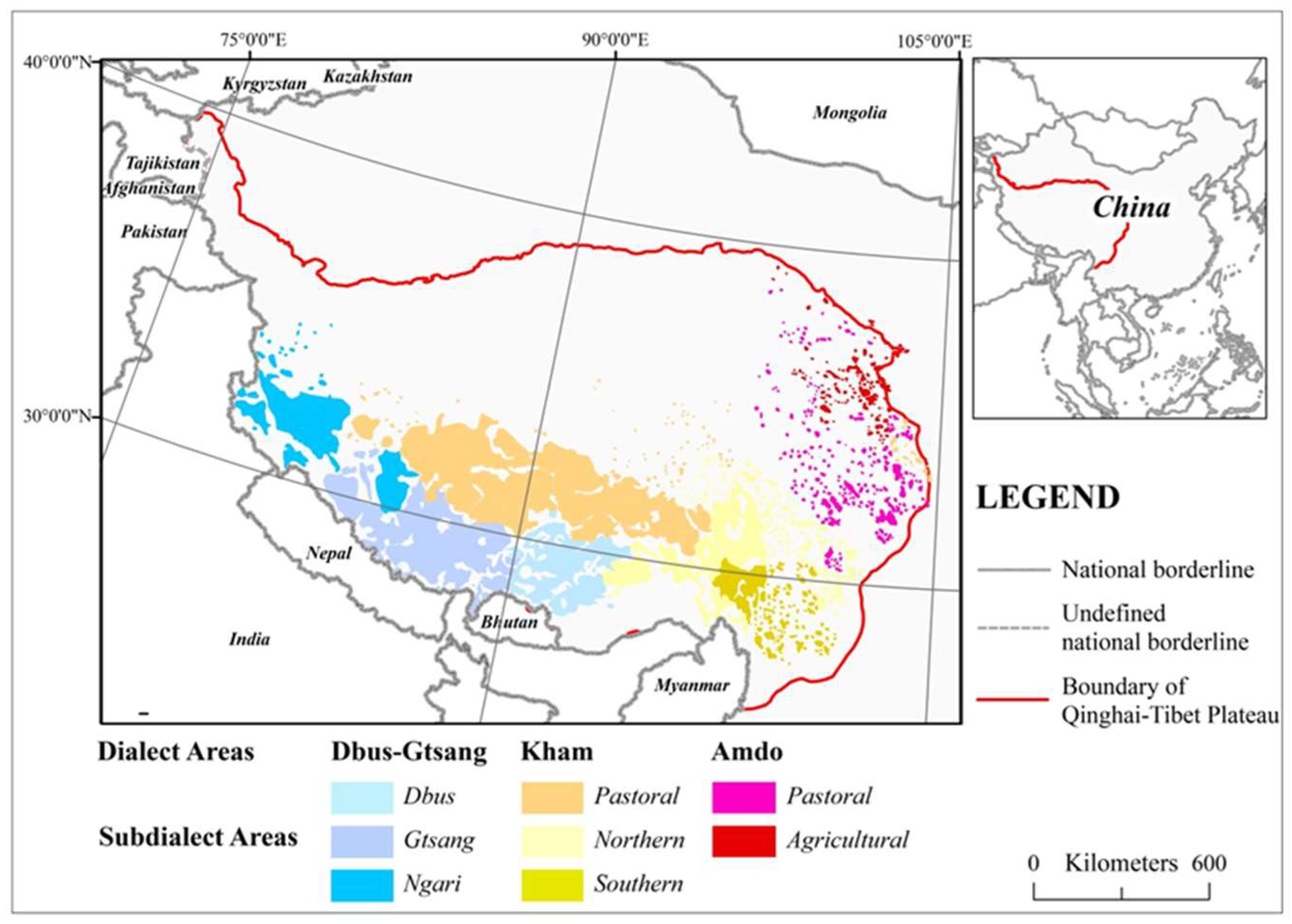
2.2. Existing Methods for Determining the Tibetan Dialect Area Boundary
2.3. Combination of Maps and Language
3. Study Area
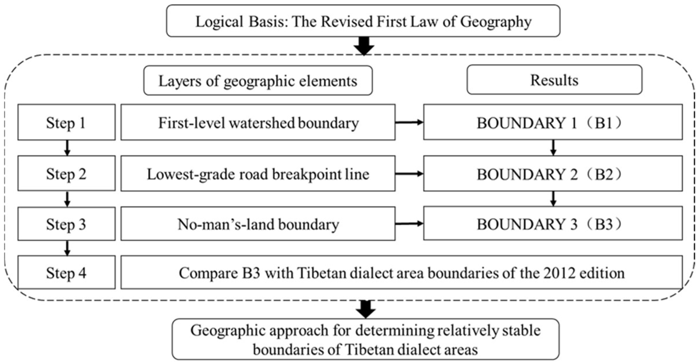
4. Research Methods
5. Analysis
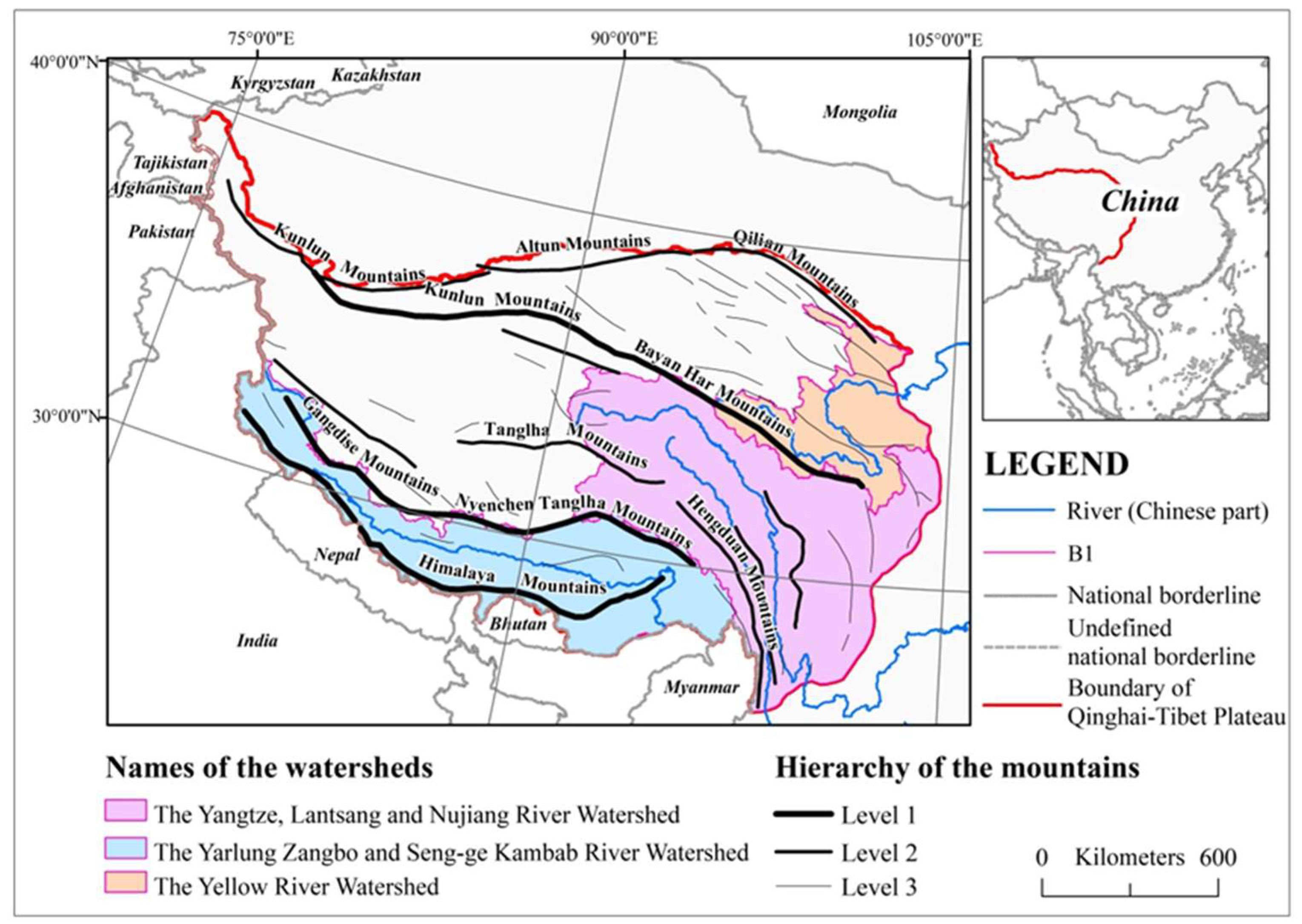
5.1. Determine First-Level Watershed Boundaries (B1)
5.2. Modify B1 with the Lowest-Grade Road Breakpoint Line (B2)
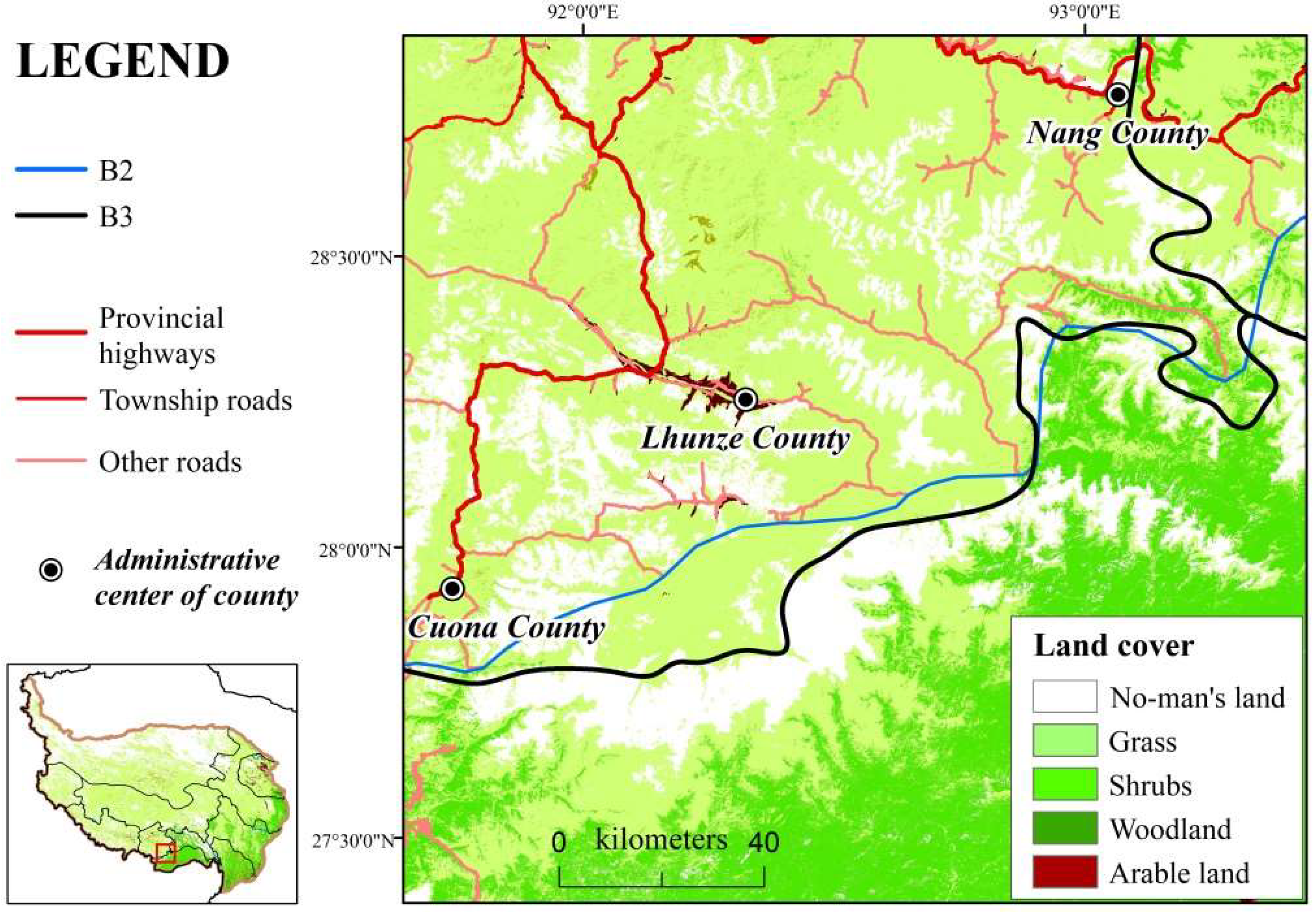
5.3. Amend B2 with No-Man’s-Land Boundaries (B3)
5.4. Correct Seven Segments of the (Sub)Dialect Area Boundaries
5.5. Evaluate the Stability of (Sub)Dialect Area Boundaries
6. Conclusions and Discussion
6.1. Conclusions
6.2. Discussion
Author Contributions
Funding
Institutional Review Board Statement
Informed Consent Statement
Data Availability Statement
Acknowledgments
Conflicts of Interest
References
- Sheller, M.; Urry, J. The new mobilities paradigm. Environ. Plan. A 2006, 38, 207–226. [Google Scholar] [CrossRef] [Green Version]
- Atkinson, D.; Jackson, P.; Sibley, D.; Washbourne, N. Cultural Geography. A Critical Dictionary of Key Concepts; IB Tauris: London, UK, 2005; pp. 153–154. [Google Scholar]
- Tuan, Y.F. Escapism; JHU Press: Baltimore, MD, USA, 1998; pp. 22–24. [Google Scholar]
- Kitchin, R.; Dodge, M. Rethinking maps. Prog. Hum. Geogr. 2007, 31, 331–344. [Google Scholar] [CrossRef]
- Wardhaugh, R.; Fuller, J.M. An Introduction to Sociolinguistics; John Wiley & Sons: Hoboken, NJ, USA, 2021; p. 27. [Google Scholar]
- Dooly, M.; Vallejo Rubinstein, C. Bridging across languages and cultures in everyday lives: An expanding role for critical intercultural communication. Lang. Intercult. Commun. 2018, 18, 1–8. [Google Scholar] [CrossRef] [Green Version]
- Basile, R.; Capello, R.; Caragliu, A. Interregional knowledge spillovers and economic growth: The role of relational proximity. In Drivers of Innovation, Entrepreneurship and Regional Dynamics; Springer: Berlin/Heidelberg, Germany, 2011; pp. 21–43. [Google Scholar]
- Weidenfeld, A.; Björk, P.; Williams, A.M. Cognitive and cultural proximity between service managers and customers in cross-border regions: Knowledge transfer implications. Scand. J. Hosp. Tour. 2016, 16 (Suppl. 1), 66–86. [Google Scholar] [CrossRef] [Green Version]
- Segrott, J. Language, geography and identity: The case of the Welsh in London. Soc. Cult. Geogr. 2001, 2, 281–296. [Google Scholar] [CrossRef]
- Stafecka, A. Latvian dialects in the 21 century: Old and new borders. Acta Balt. Slav. 2015, 39, 1–13. [Google Scholar] [CrossRef] [Green Version]
- Haugen, E. Dialect, Language, Nation. Am. Anthropol. 1966, 68, 922–935. [Google Scholar] [CrossRef]
- Fernández-Villanueva, M.; Jungbluth, K. Beyond Language Boundaries: Multimodal Use in Multilingual Contexts; Walter de Gruyter GmbH & Co KG: Berlin, Germany, 2016. [Google Scholar]
- Kessler, B. Computational dialectology in Irish Gaelic. In Proceedings of the Seventh Conference on European Chapter of the Association for Computational Linguistics, Dublin, Ireland, 27–31 March 1995. [Google Scholar]
- Auer, P. The geography of language: Steps toward a new approach. FRAGL Freibg. Arb. Zur Ger. Linguist. 2013, 16, 11. [Google Scholar]
- Gregory, D.; Johnston, R.; Pratt, G.; Watts, M.; Whatmore, S. The Dictionary of Human Geography; Basil Blackwell: Oxford, UK, 1981; p. 441. [Google Scholar]
- Survey Manual of Chinese Language Resources • Ethnic Languages (Tibeto-Burman Group). Available online: http://www.chinalanguages.cn/gongjuyangben.html (accessed on 6 March 2022).
- Zelinsky, W.; Williams, C.H. The mapping of language in North America and the British Isles. Prog. Hum. Geogr. 1988, 12, 337–368. [Google Scholar] [CrossRef]
- Jagessar, P. Geography and linguistics: Histories, entanglements and departures. Geogr. Compass 2020, 14, 1–10. [Google Scholar] [CrossRef]
- Heeringa, W.; Nerbonne, J. Dialect areas and dialect continua. Lang. Var. Change 2001, 13, 375–400. [Google Scholar] [CrossRef] [Green Version]
- Britain, D. Space, Diffusion and Mobility. Handb. Lang. Var. Change 2013, 129, 471. [Google Scholar]
- Braudel, F. History and the social sciences: The long term. Soc. Sci. Inf. 1970, 9, 144–174. [Google Scholar] [CrossRef]
- De Busser, R.; LaPolla, R.J. Language Structure and Environment: Social, Cultural, and Natural Factors; John Benjamins Publishing Company: Amsterdam, The Netherlands, 2015; Volume 6. [Google Scholar]
- Mullonen, I.; Zaiceva, N. Areal distribution of Veps topographical vocabulary. Linguist. Ural. 2017, 53, 106. [Google Scholar]
- Bisang, W. Areal typology and grammaticalization: Processes of grammaticalization based on nouns and verbs in East and mainland South East Asian languages. Stud. Lang. 1996, 20, 519–597. [Google Scholar] [CrossRef] [Green Version]
- Podobnikar, T.; Škofic, J.; Horvat, M. Mapping and analysing the local language areas for Slovenian linguistic atlas. In Cartography in Central and Eastern Europe; Springer: Berlin/Heidelberg, Germany, 2009; pp. 361–382. [Google Scholar]
- Tönnies, M. Foregrounding Boundary Zones: Martin Parr’s Photographic (De-)Constructions of Englishness. In Landscape and Englishness; Brill Academic Publishers: New York, NY, USA, 2006; pp. 225–240. [Google Scholar]
- Terry, G.J.; Lester, R.; Hsu, M.L. The Human Mosaic: A Thematic Introduction to Cultural Geography; Harpercollins College Div: New York, NJ, USA, 1976; pp. 141–168. [Google Scholar]
- Zhang, W.J. Three important north-south lines in Chinese dialects. Lang. Res. 2018, 38, 1–14. [Google Scholar]
- Shafer, R. Classification of the Sino-Tibetan languages. Word 1955, 11, 94–111. [Google Scholar] [CrossRef] [Green Version]
- Malmberg, B. Structural Linguistics and Human Communication; Springer: Berlin/Heidelberg, Germany, 1963. [Google Scholar]
- Rohlf, G. A preliminary investigation of the urban morphology of towns of the Qinghai-Tibet plateau. Chin. Hist. Geogr. Perspect. 2015, 159–178. [Google Scholar]
- Urban, M. The geography and development of language isolates. R. Soc. Open Sci. 2021, 8, 202–232. [Google Scholar] [CrossRef]
- Bennett, C.J. The morphology of language boundaries: Indo-Aryan and Dravidian in peninsular India. Geogr. Perspect. Soc. Cult. 1980, 234–251. [Google Scholar]
- Dorji, J. Hen Kha: A Dialect of Mangde Valley in Bhutan. J. Bhutan Stud. 2011, 24, 69–86. [Google Scholar]
- Hermanns, M. Tibetische Dialekte von Amdo. Anthropos 1952, H. 1/2, 193–202. [Google Scholar]
- Chamberlain, B. Linguistic watersheds: A model for understanding variation among the Tibetic languages. J. Southeast Asian Linguist. Soc. 2015, 8, 71–96. [Google Scholar]
- Tournadre, N. The Tibetic languages and their classification. In Trans-Himalayan Linguistics; De Gruyter Mouton: Berlin, Germany, 2013; pp. 105–130. [Google Scholar]
- Roche, G. Introduction: The transformation of Tibet’s language ecology in the twenty-first century. Int. J. Sociol. Lang. 2017, 245, 1–35. [Google Scholar] [CrossRef]
- Chen, R.Z. The distribution pattern of Tibetan dialects and its historical, geographical and humanistic background. J. Minzu Univ. China Philos. Soc. Sci. Ed. 2016, 43, 128–134. [Google Scholar]
- Qu, A.T.; Jin, X.J. Research methods of Tibetan dialects. J. Southwest Inst. Natl. Philos. Soc. Sci. 1981, 3, 79–87. [Google Scholar]
- Kelsang, J.M.; Kelsang, Y.J. An Introduction to Tibetan Dialects; Nationalities Publishing House: Beijing, China, 2002; pp. 1–3. [Google Scholar]
- Chinese Academy of Social Sciences. Language Atlas of China; Commercial Press: Beijing, China, 2012. [Google Scholar]
- Britain, D. The role of mundane mobility and contact in dialect death and dialect birth. In English as a Contact Language; Hundt, M., Schreier, D., Eds.; Cambridge University Press: Cambridge, UK, 2013; pp. 165–181. [Google Scholar]
- Hildebrandt, K.A.; Hu, S. Areal analysis of language attitudes and practices: A case study from Nepal. In Documenting Variation in Endangered Languages; University of Hawai’i Press: Honolulu, HI, USA, 2017; pp. 1–5. [Google Scholar]
- Fast, K.; Ljungberg, E.; Braunerhielm, L. On the social construction of geomedia technologies. Commun. Public 2019, 4, 89–99. [Google Scholar] [CrossRef]
- Akmajian, A.; Farmer, A.K.; Bickmore, L. Linguistics: An Introduction to Language and Communication; MIT Press: Cambridge, MA, USA, 2017. [Google Scholar]
- Keesing, R.M. Theories of culture. Annu. Rev. Anthropol. 1974, 3, 73–97. [Google Scholar] [CrossRef]
- Griebel, B.; Keith, D. Mapping Inuinnaqtun: The Role of Digital Technology in the Revival of Traditional Inuit Knowledge Ecosystems. ISPRS Int. J. Geo-Inf. 2021, 10, 749. [Google Scholar] [CrossRef]
- Aporta, C.; Kritsch, I.; Andre, A. The Gwich’in Atlas: Place names, maps, and narratives. In Modern Cartography Series; Academic Press: New York, NJ, USA, 2014; Volume 5, pp. 229–244. [Google Scholar]
- Edler, D.; Kühne, O.; Keil, J. Audiovisual cartography: Established and new multimedia approaches to represent soundscapes. KN-J. Cartogr. Geogr. Inf. 2019, 69, 5–17. [Google Scholar] [CrossRef] [Green Version]
- Krygier, J.B. Sound and geographic visualization. In Visualization in Modern Cartography; MacEachren, A.M., Taylor, D.R.F., Eds.; Elsevier: Oxford, UK, 1994; pp. 149–166. [Google Scholar]
- Pulsifer, P.L.; Caquard, S.; Taylor, D.R. Toward a new generation of community atlases—The cybercartographic atlas of Antarctica. In Multimedia Cartography; Springer: Berlin/Heidelberg, Germany, 2007; pp. 195–216. [Google Scholar]
- Hruby, F. The sound of being there: Audiovisual cartography with immersive virtual environments. KN-J. Cartogr. Geogr. Inf. 2019, 69, 19–28. [Google Scholar] [CrossRef] [Green Version]
- Schito, J.; Fabrikant, S.I. Exploring maps by sounds: Using parameter mapping sonification to make digital elevation models audible. Int. J. Geogr. Inf. Sci. 2018, 32, 874–906. [Google Scholar] [CrossRef]
- Tobler, W.R. A Computer Movie Simulating Urban Growth in the Detroit Region. Econ. Geogr. 1970, 46 (Suppl. 1), 234–240. [Google Scholar] [CrossRef]
- Wang, J.; Zuo, W. The Geographical Atlas of China; SinoMaps Press: Beijing, China, 2010. [Google Scholar]
- Golledge, R.G. Spatial Behavior: A Geographic Perspective; Guilford Press: New York, NJ, USA, 1997. [Google Scholar]
- Derungs, C.; Sieber, C.; Glaser, E.; Weibel, R. Dialect borders—Political regions are better predictors than economy or religion. Digit. Scholarsh. Humanit. 2020, 35, 276–295. [Google Scholar] [CrossRef]
- Schaffter, M.; Fall, J.J.; Debarbieux, B. Unbounded boundary studies and collapsed categories: Rethinking spatial objects. Prog. Hum. Geogr. 2010, 34, 254–262. [Google Scholar] [CrossRef]
- Jackson, P. Maps of Meaning; Taylor & Francis: London, UK, 2012; pp. 155–170. [Google Scholar]


| Situation | Schematic | Drawing Method |
|---|---|---|
| Lowest-grade road breakpoints appear on both sides |  1 1 | Join the midpoint of the two endpoints in turn |
| Only one side has the lowest-grade road breakpoints |  | Connect the road breakpoints directly in turn |
| Location | Type in the 2012 Map | Type after Modification | Possible Reasons for the Difference |
|---|---|---|---|
| Northeast of Coqen and Zhongba County (Ngari and Shigatse, Tibet) | Ngari and Gtsang (Dbus-Gtsang) | Pastoral (Kham) | First-level watershed boundary and road breakpoint line |
| Northern Baxoi County (Qamdo city, Tibet) | Northern (Kham) | Pastoral (Kham) | Road breakpoint line extends south to Bowo county and northern Baxoi County |
| Most of Gongbo’gyamda County (Nyingchi city, Tibet) | Gtsang (Dbus-Gtsang) | Northern (Kham) | No-man’s-land boundary on the west |
| Northeastern Batang County and Litang County (Garze Prefecture, Sichuan) | Southern (Kham) | Northern (Kham) | Clear road breakpoint line |
| Nangchen County and Yushu city (Yushu city, Qinghai) | Northern (Kham) | Pastoral (Kham) | Road breakpoint line |
| Xinghai County and Zeku County (Hainan Tibetan Autonomous Prefecture, Huangnan Tibetan Autonomous Prefecture, Qinghai) | Pastoral (Amdo) | Agricultural (Amdo) | Road breakpoint line |
| Eastern Gangca County, eastern Menyuan Hui Autonomous County (Haibei Tibetan Autonomous Prefecture, Qinghai) | Pastoral (Amdo) | Agricultural (Amdo) | Road breakpoint line |
| Indicators | Level of Stability | Grade | Index |
|---|---|---|---|
| First-level watershed boundary (mountains) | High | Level 1 | ++++ 1 |
| Level 2 | +++ | ||
| Level 3 | ++ | ||
| No-man’s-land boundary | Medium | Clear | +++ |
| Generally clear | ++ | ||
| Lowest-grade road breakpoint line | Low | Clear | ++ |
| Generally clear | + |
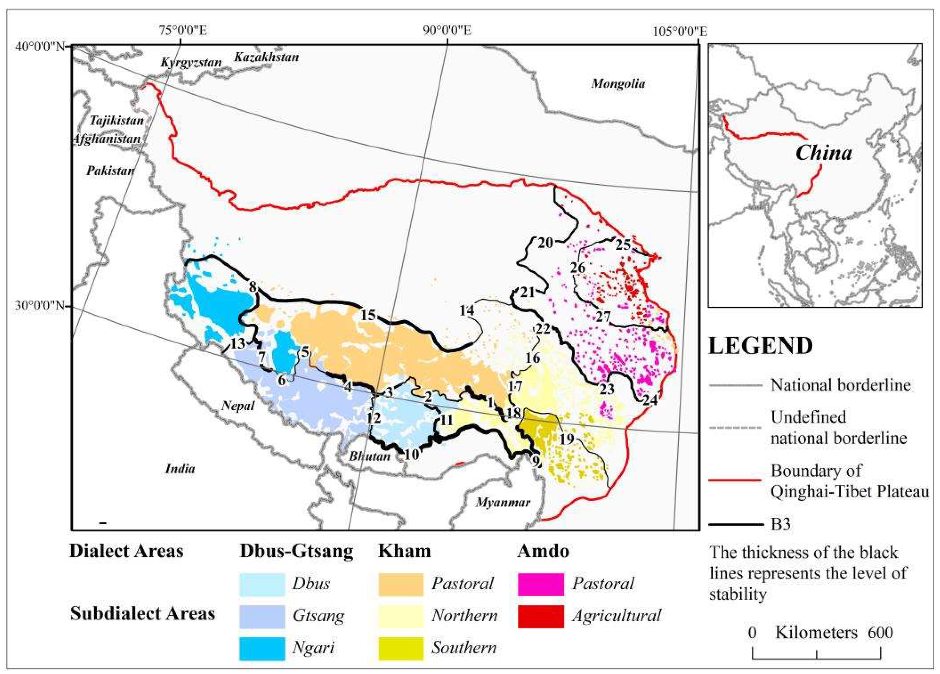
| Segment Number | Boundary | Stability Influencing Indicators | Level of Stability |
|---|---|---|---|
| 1 | Dbus-Gtsang and Kham | Clear road breakpoint line, clear no-man’s-land boundary, level 1 mountains | +++++++++ 1 |
| 2 | Dbus-Gtsang and Kham | Generally clear road breakpoint line, generally clear no-man’s-land boundary | +++ |
| 3 | Dbus-Gtsang and Kham | Clear road breakpoint line, clear no-man’s-land boundary | +++++ |
| 4 | Dbus-Gtsang and Kham | Clear no-man’s-land boundary, level 1 mountains, generally clear road breakpoint line | ++++++++ |
| 5 | Dbus-Gtsang and Kham | Clear road breakpoint line | ++ |
| 6 | Dbus-Gtsang and Kham | Generally clear road breakpoint line | + |
| 7 | Dbus-Gtsang and Kham | Generally clear road breakpoint line, level 1 mountains, generally clear no-man’s-land boundary | +++++++ |
| 8 | Dbus-Gtsang and Kham | Generally clear road breakpoint lines, generally clear no-man’s-land boundary, level 2 mountains | ++++++ |
| 9 | Northern and Southern subdialect area | Clear road breakpoint lines, clear no-man’s-land boundary, level 3 mountains | +++++++ |
| 10 | Dbus-Gtsang/Kham dialect area and no-man’s land | Clear road breakpoint lines, clear no-man’s-land boundary, level 1 mountains | +++++++++ |
| 11 | Dbus-Gtsang and Kham | Generally clear no-man’s-land boundary, level 3 mountain range, generally clear road breakpoint line | +++++ |
| 12 | Dbus and Gtsang | Generally clear no-man’s-land boundary, generally clear road breakpoint line | +++ |
| 13 | Ngari and Gtsang | Clear road breakpoint line, generally clear no-man’s-land boundary | ++++ |
| 14 | Kham dialect area and no-man’s land | Clear road breakpoint line | ++ |
| 15 | Kham dialect area and no-man’s land | Clear road breakpoint line, generally clear no-man’s-land boundary, level 2 mountains | +++++++ |
| 16 | Northern and pastoral subdialect area | Clear road breakpoint line | ++ |
| 17 | Northern and pastoral subdialect area | Generally clear road breakpoint line, clear no-man’s-land boundary | ++++ |
| 18 | Northern and pastoral subdialect area | Clear road breakpoint line, generally clear no-man’s-land boundary | ++++ |
| 19 | Southern and Northern subdialect area | Clear road breakpoint line | ++ |
| 20 | Amdo dialect area and no-man’s land | Clear road breakpoint line, generally clear no-man’s-land boundary | ++++ |
| 21 | Amdo dialect area and no-man’s land | Clear road breakpoint line, generally clear no-man’s-land boundary | ++++ |
| 22 | Amdo and Kham | Clear road breakpoint line, level 1 mountains | ++++++ |
| 23 | Amdo and Kham | Generally clear road breakpoint line, level 1 mountains | +++++ |
| 24 | Amdo and Kham | Generally clear road breakpoint line, level 3 mountains | +++ |
| 25 | Agricultural and pastoral subdialect area | Generally clear road breakpoint line, level 2 mountains | ++++ |
| 26 | Agricultural and pastoral subdialect area | Clear road breakpoint line | ++ |
| 27 | Agricultural and pastoral subdialect area | Clear road breakpoint line, level 3 mountains | ++++ |
Publisher’s Note: MDPI stays neutral with regard to jurisdictional claims in published maps and institutional affiliations. |
© 2022 by the authors. Licensee MDPI, Basel, Switzerland. This article is an open access article distributed under the terms and conditions of the Creative Commons Attribution (CC BY) license (https://creativecommons.org/licenses/by/4.0/).
Share and Cite
Duan, M.; Zhou, S. Geographic Approach: Identifying Relatively Stable Tibetan Dialect and Subdialect Area Boundaries. ISPRS Int. J. Geo-Inf. 2022, 11, 280. https://doi.org/10.3390/ijgi11050280
Duan M, Zhou S. Geographic Approach: Identifying Relatively Stable Tibetan Dialect and Subdialect Area Boundaries. ISPRS International Journal of Geo-Information. 2022; 11(5):280. https://doi.org/10.3390/ijgi11050280
Chicago/Turabian StyleDuan, Mingyuan, and Shangyi Zhou. 2022. "Geographic Approach: Identifying Relatively Stable Tibetan Dialect and Subdialect Area Boundaries" ISPRS International Journal of Geo-Information 11, no. 5: 280. https://doi.org/10.3390/ijgi11050280
APA StyleDuan, M., & Zhou, S. (2022). Geographic Approach: Identifying Relatively Stable Tibetan Dialect and Subdialect Area Boundaries. ISPRS International Journal of Geo-Information, 11(5), 280. https://doi.org/10.3390/ijgi11050280