
Spectral Index for Mapping Topsoil Organic Matter Content Based on ZY1-02D Satellite Hyperspectral Data in Jiangsu Province, China


Abstract
:1. Introduction
2. Materials and Methods
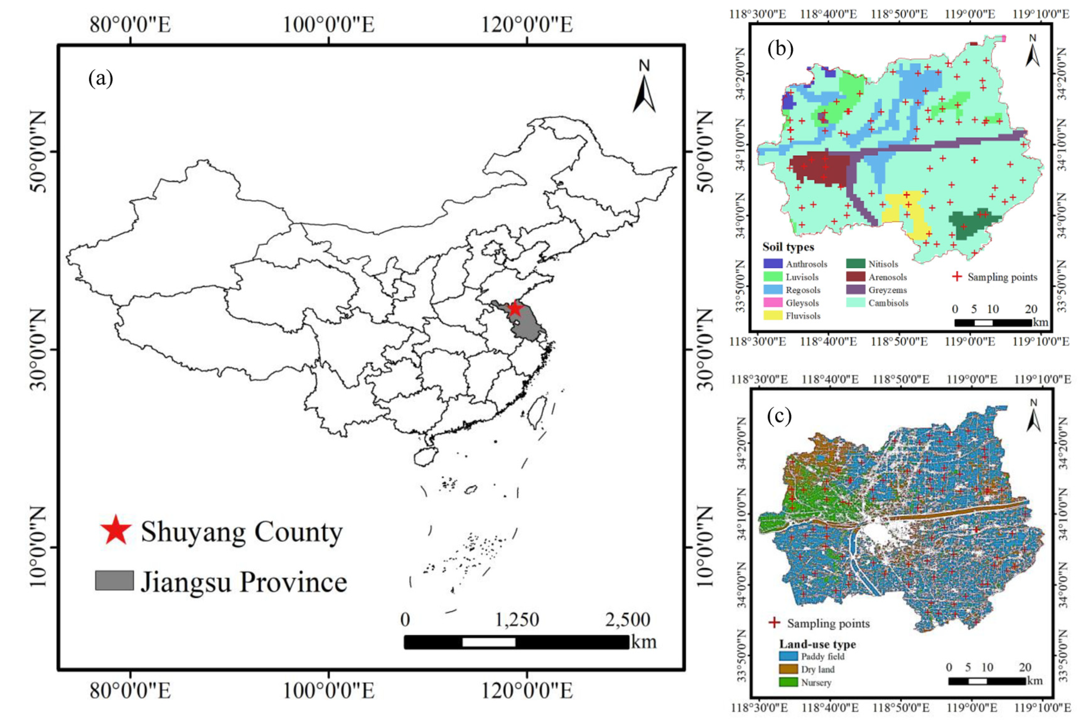
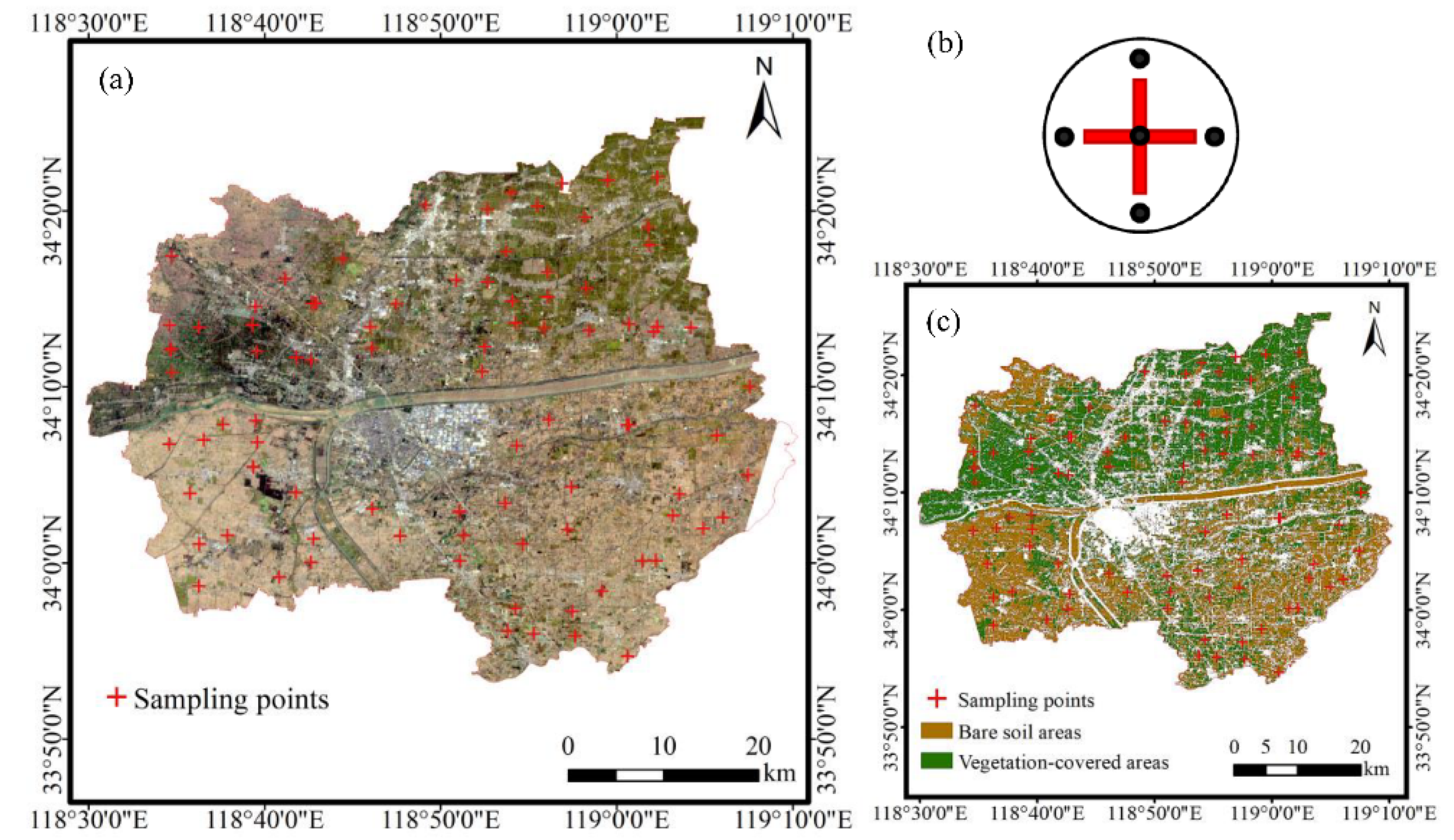
2.1. Study Area
2.2. Hyperspectral Satellite Data Acquisition and Preprocessing
2.3. Ground Sampling and Soil Measurements
2.4. Methods
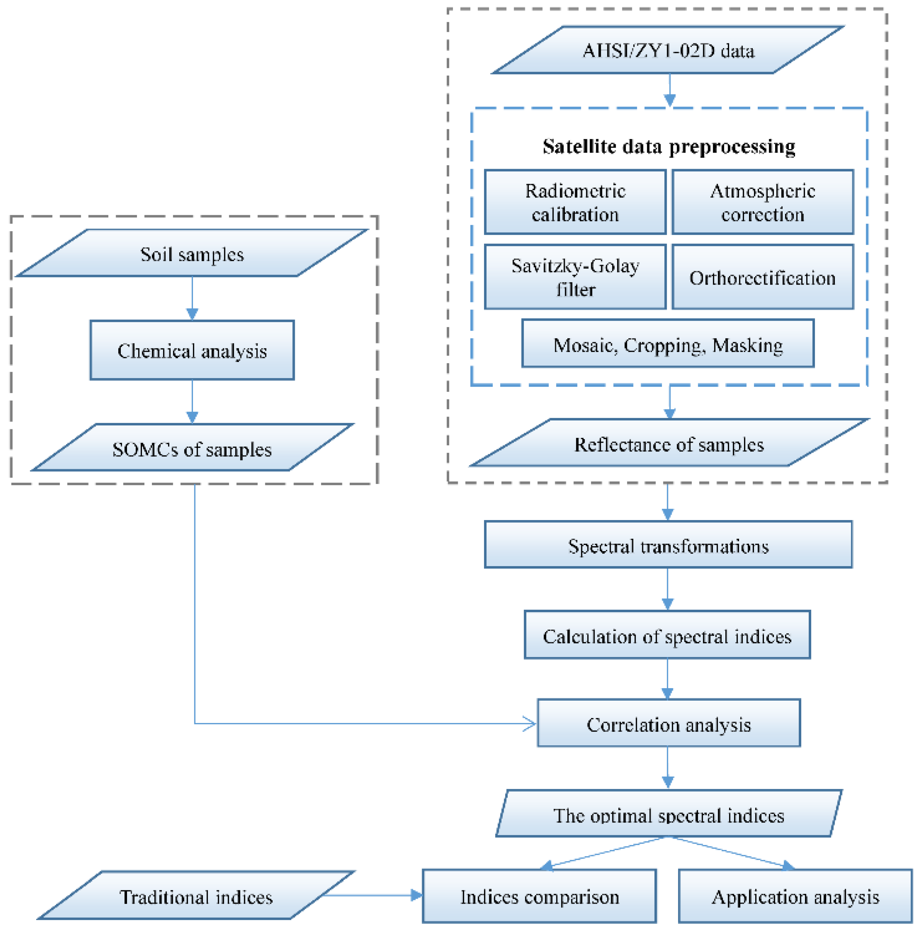
2.4.1. Research Process
2.4.2. Construction of the Optimal SIs
2.4.3. Application Assessment of the Optimal SIs

| Index Type | Abbreviation | Formula | Properties | References |
|---|---|---|---|---|
| Soil SI | SOC1 | SOMC | [22] | |
| SOC2 | SOMC | [22] | ||
| SOC3 | SOMC | [22] | ||
| NSMI | Soil moisture | [50,51] | ||
| Vegetation SI | CAI | Cellulose Absorption | [52,53,54] | |
| NDLI | Lignin concentration | [53,55,56,57] | ||
| MSI | Leaf water content | [58,59] | ||
| SATVI | Total vegetation cover | [58,60] |
3. Results
3.1. Descriptive Statistics of Samples
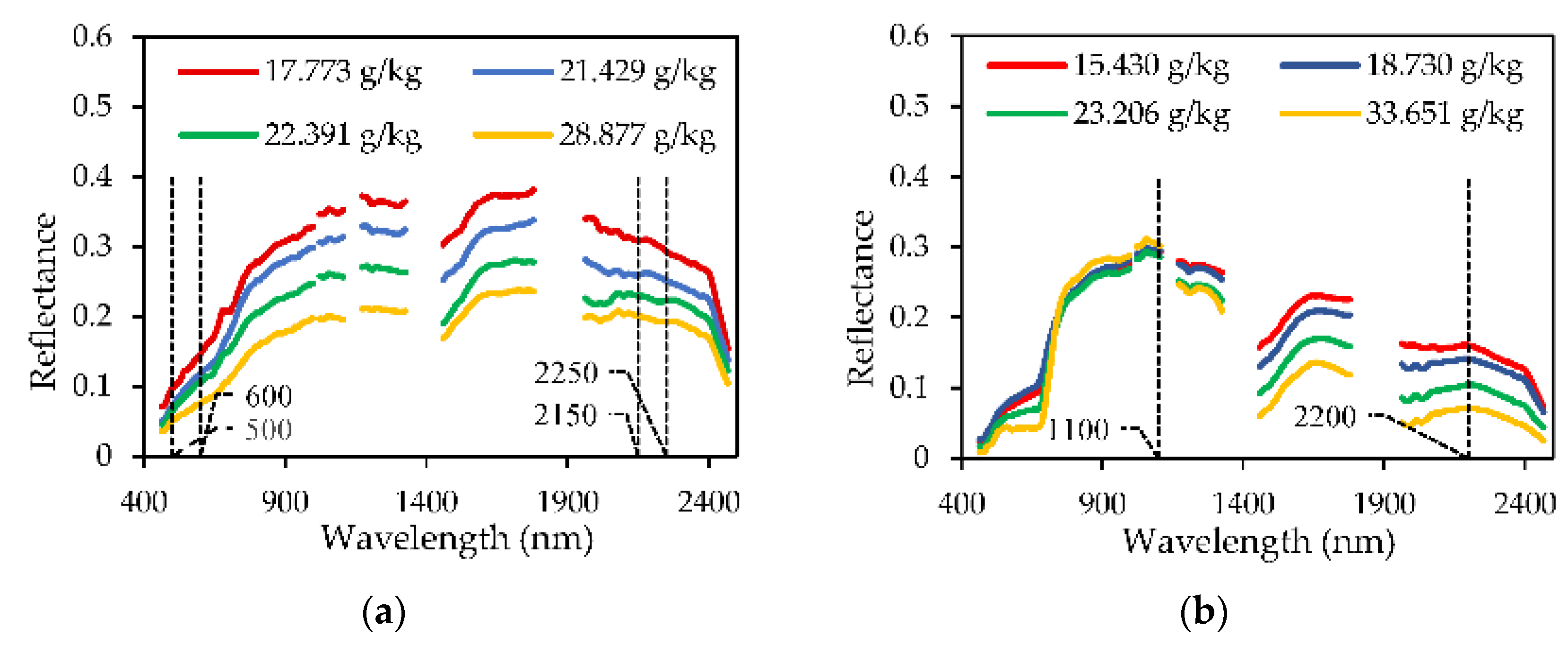
3.2. Spectral Characteristics of the Pixel Reflectance of the Sample Sites
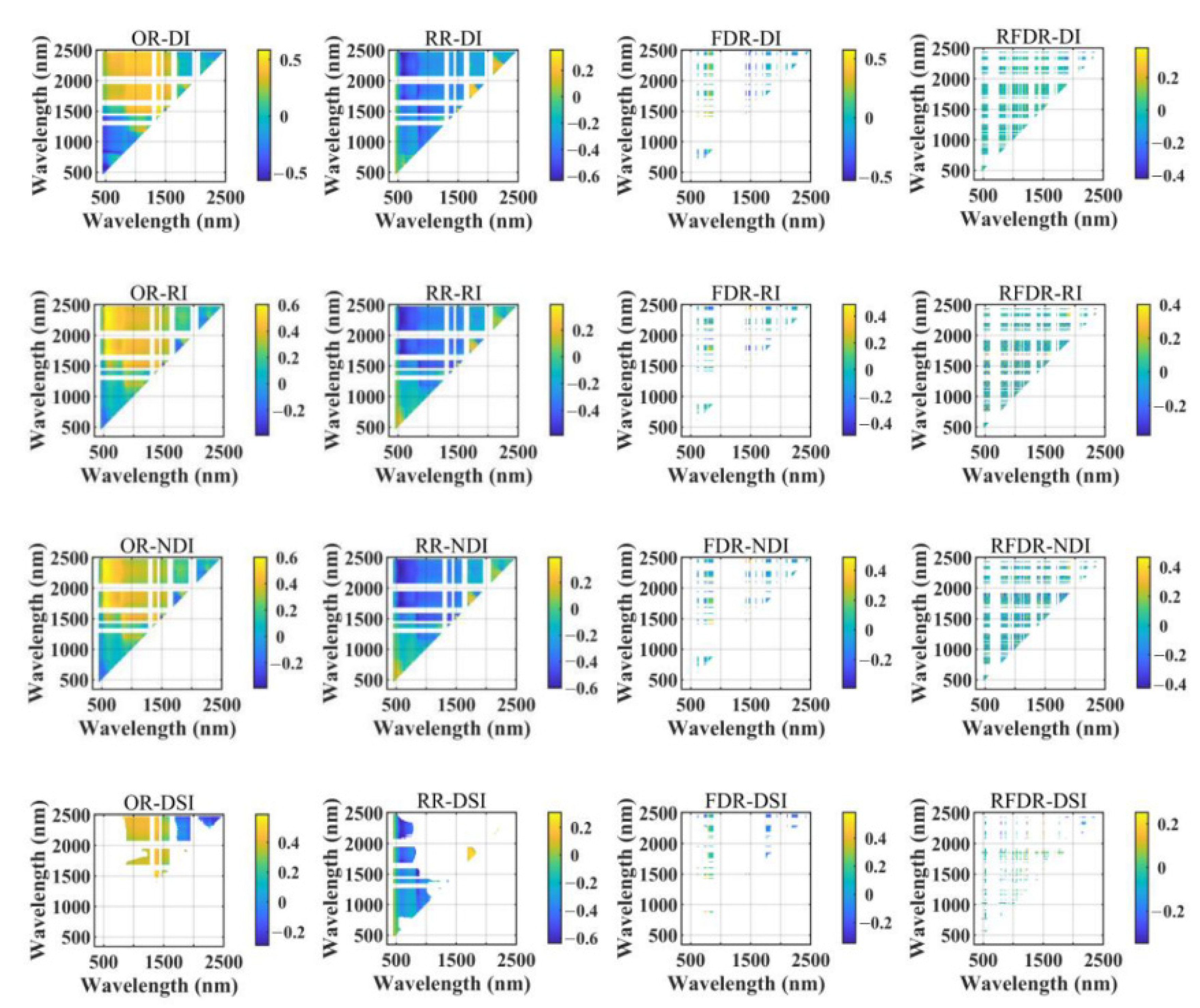
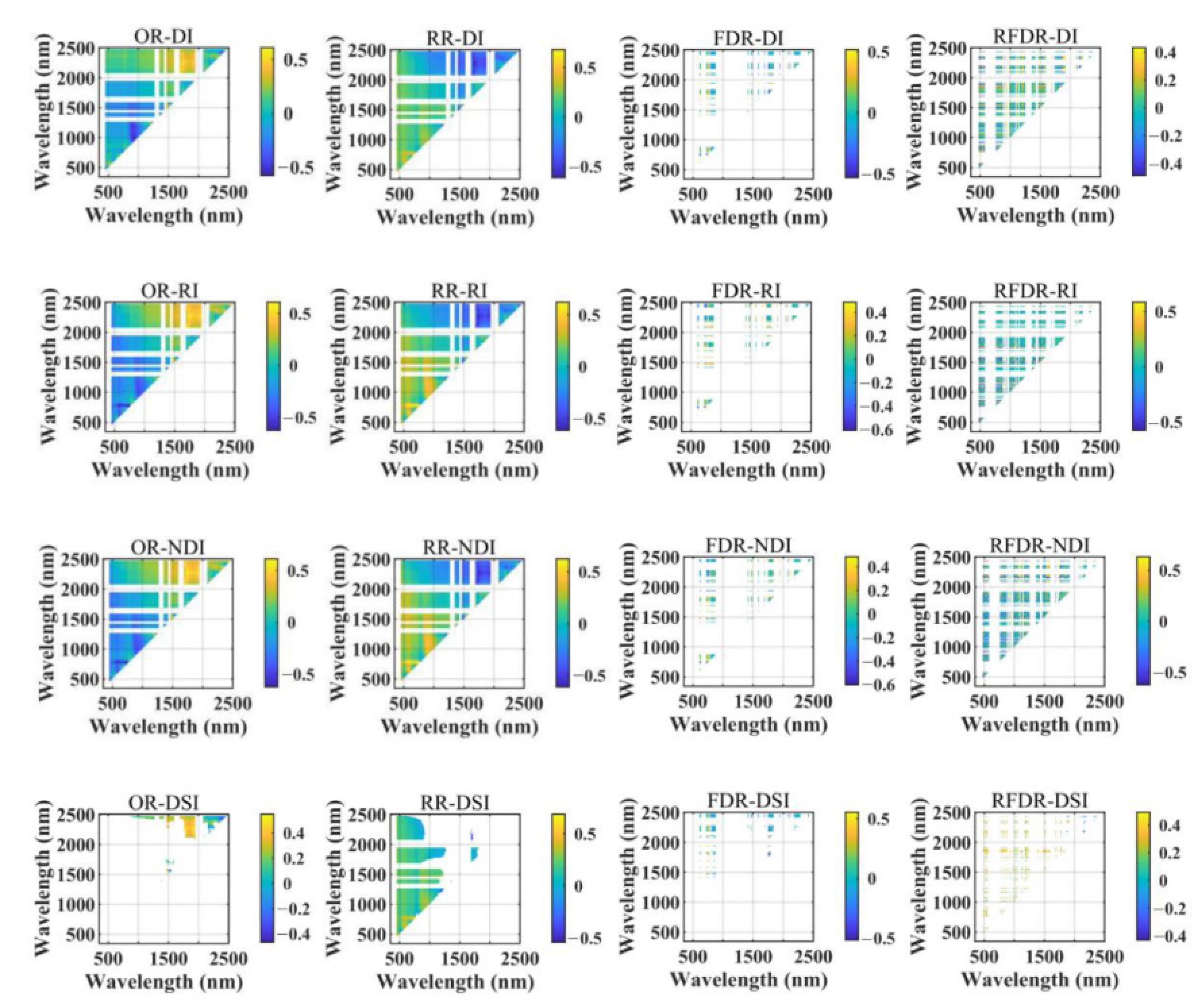
3.3. Correlation between Transformed Spectra and SOMC
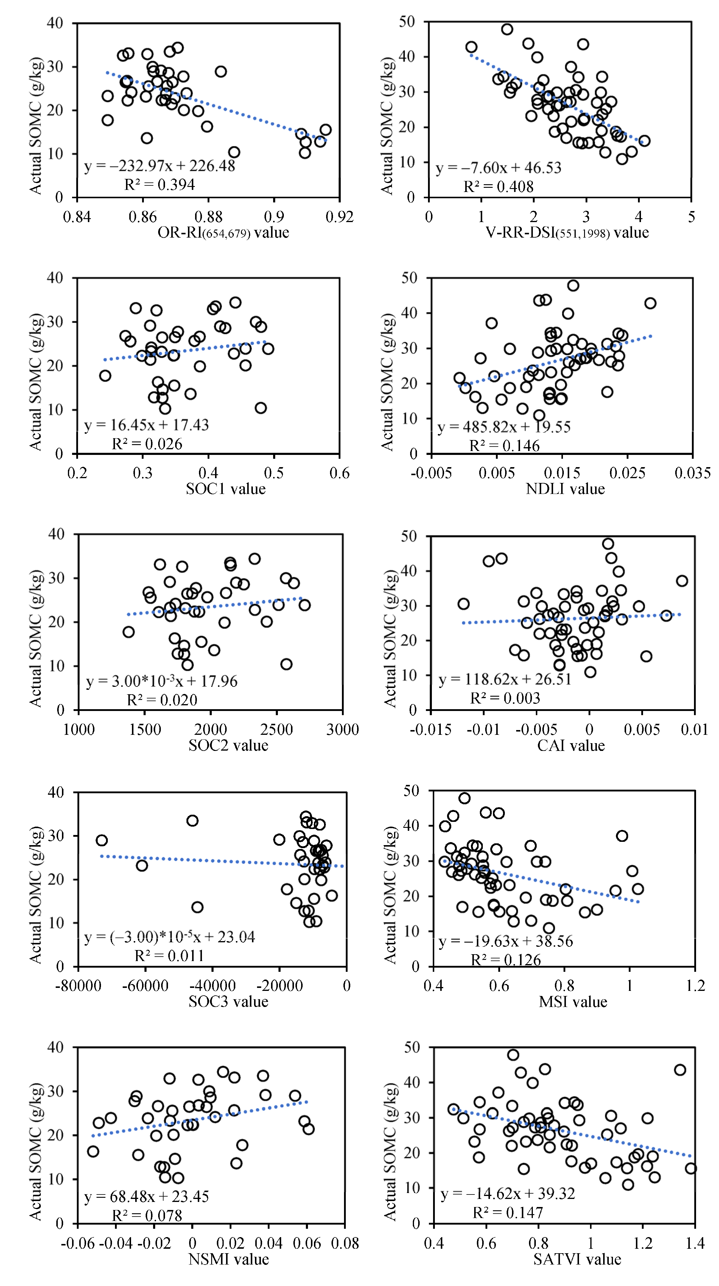
3.4. Correlation between SIs and SOMC
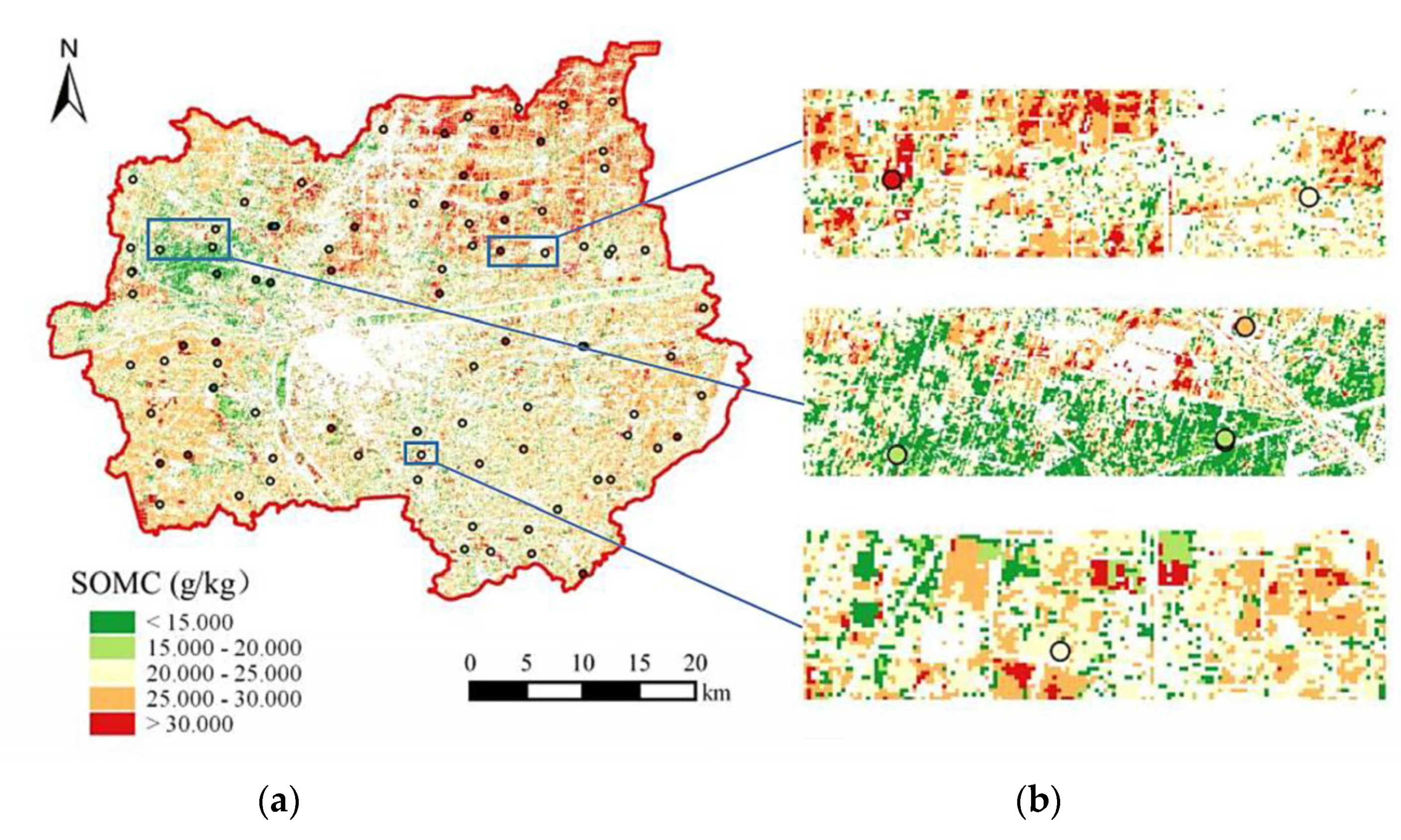
3.5. Application of the Optimal SIs
3.5.1. Characterization of SOMC in Soil Samples
3.5.2. Recognition of SOMC Levels in Soil Samples
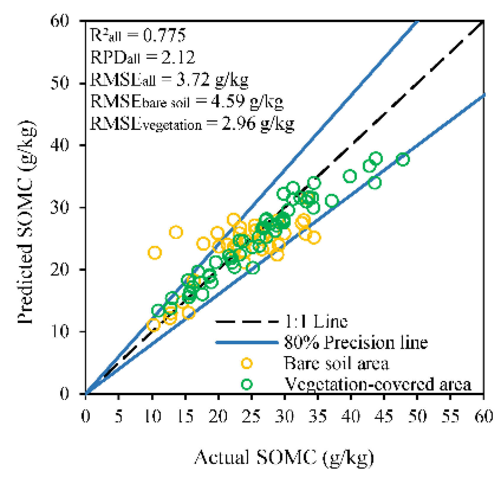
3.5.3. Estimation of SOMC in Soil Samples
4. Discussion
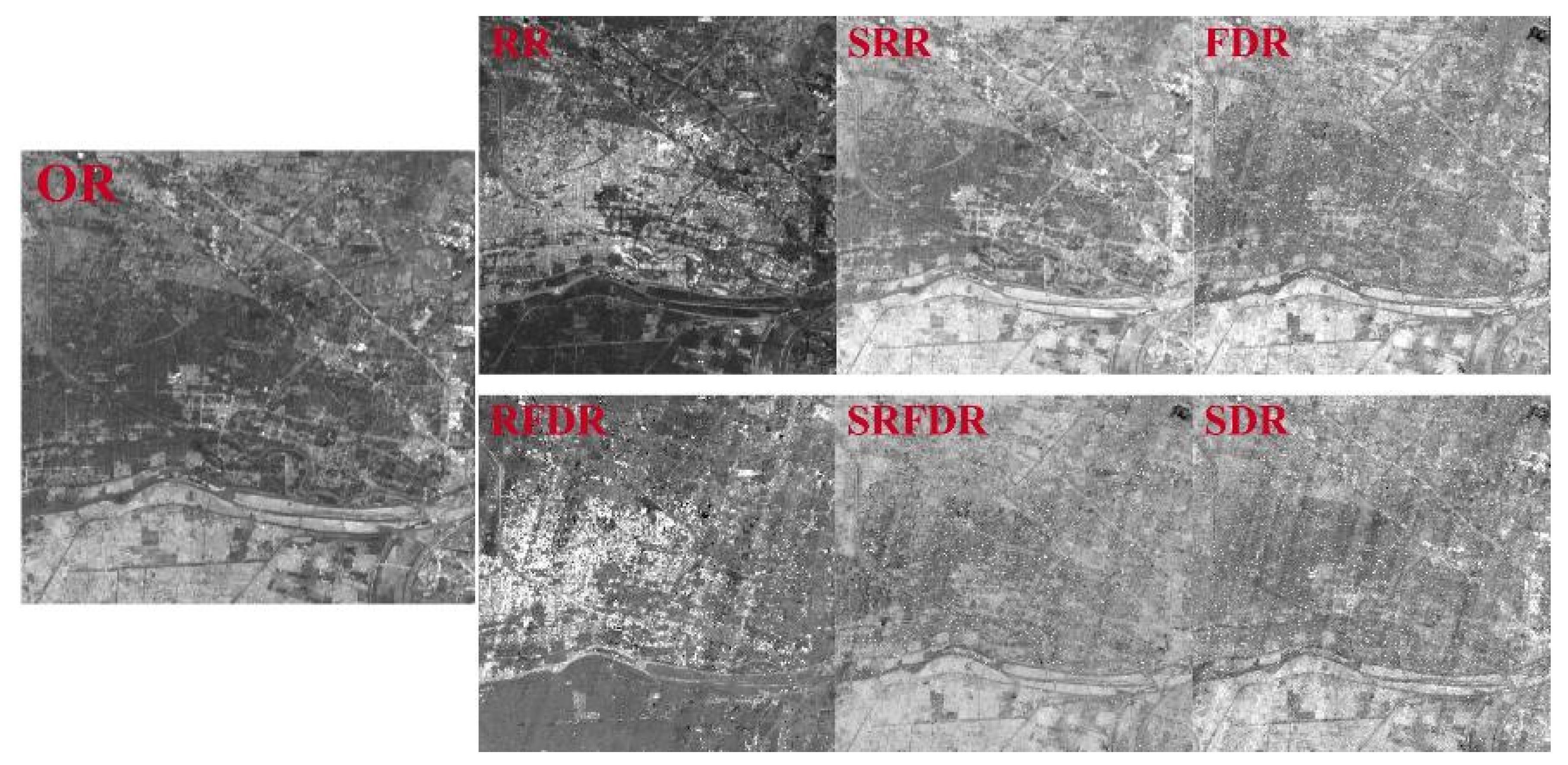
4.1. Image Quality of Transformed Spectra and SIs
4.2. Advantages of Constructing SIs Separately in Bare Soil Area and Vegetation-Covered Area
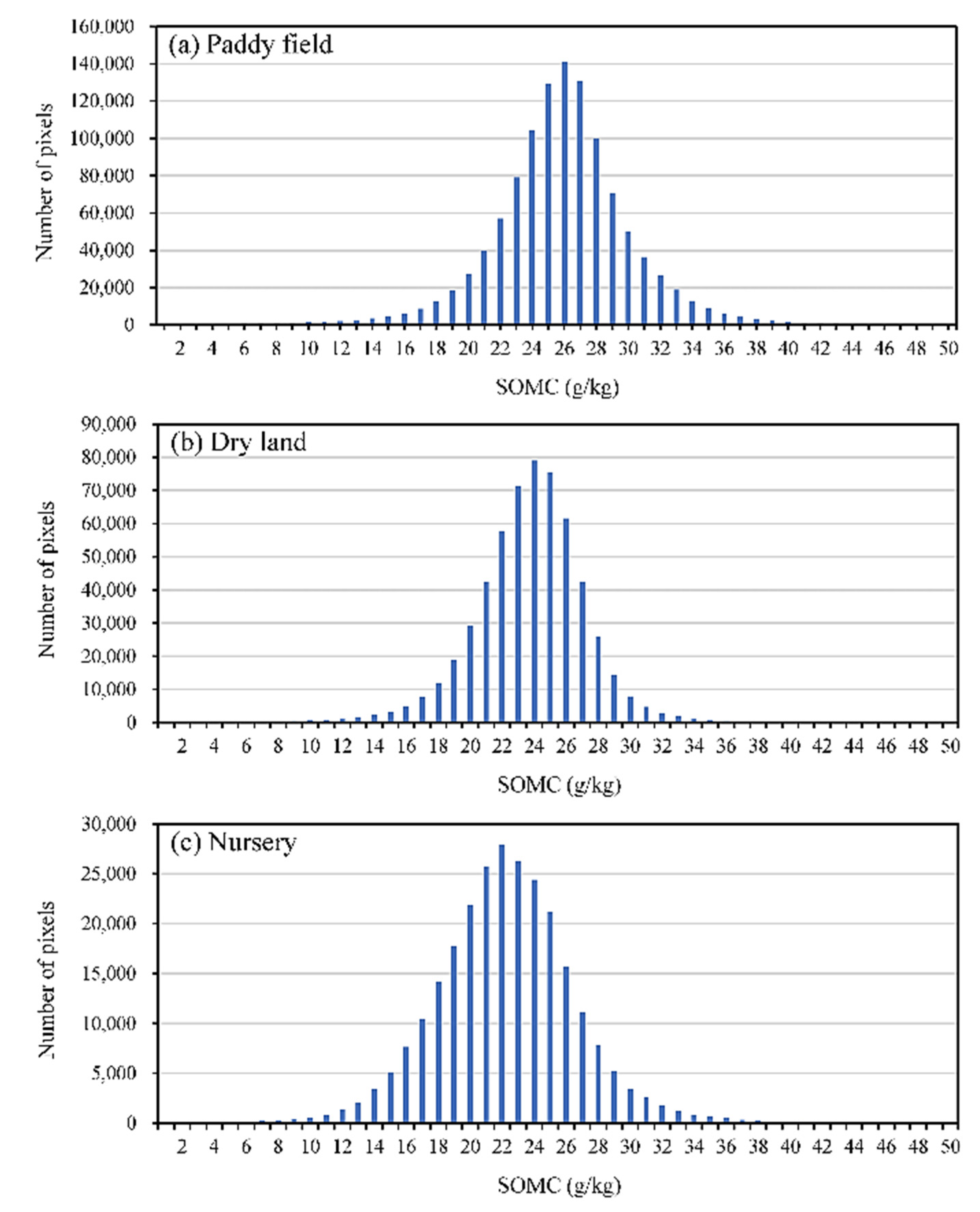
4.3. The Impacts of Soil Types and Cultivated Land-Use Type on SOMC
5. Conclusions
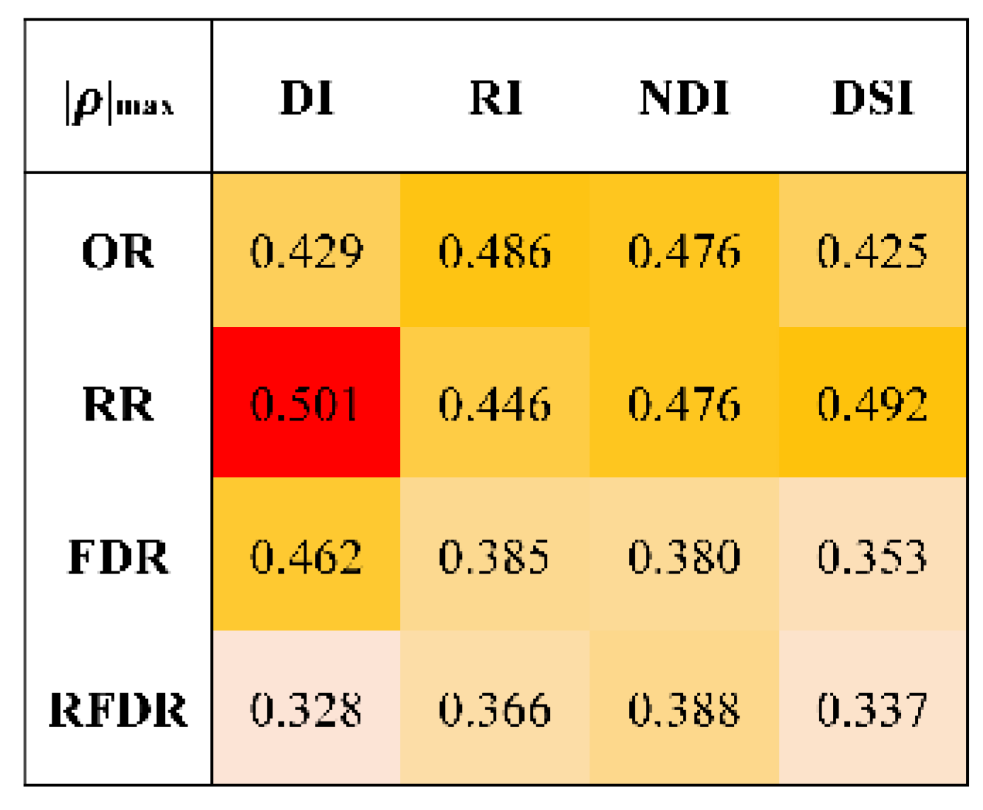
- In the bare soil area, the SIs constructed based on OR and RR have higher correlations with SOMC. For the same transformed spectrum, the SIs calculated by RI and NDI have the highest correlations with SOMC, followed by DI. Among all the constructed SIs, OR-RI(654,679) has the highest correlation with SOMC, and the correlation coefficient is 0.627. In the vegetation-covered area, the correlations between SOMC and the SIs based on RR are higher than those of other transformed spectra. Among the different index formulas, the correlations between the SIs calculated by DSI and DI and SOMC are higher than those of RI and NDI. The correlation coefficient between V-RR-DSI(551,1998) and SOMC is −0.639, which is the highest among all the calculated SIs.
- The results show that the optimal SIs can be used to present the spatial distribution trend of SOMC and recognize SOMC levels. Based on the optimal SIs, the SOMC predicted by the model has a good linear relationship with the actual SOMC of samples. The R2, RMSE and RPD of the soil-vegetation combined prediction results are 0.775, 3.72 g/kg and 2.12, respectively.
Author Contributions
Funding
Data Availability Statement
Acknowledgments
Conflicts of Interest
References
- Luo, Z.; Wang, E.; Sun, O.J. Soil carbon change and its responses to agricultural practices in Australian agro-ecosystems: A review and synthesis. Geoderma 2010, 155, 211–223. [Google Scholar] [CrossRef]
- Nocita, M.; Stevens, A.; van Wesemael, B.; Aitkenhead, M.; Bachmann, M.; Barthès, B.; Dor, E.B.; Brown, D.J.; Clairotte, M.; Csorba, A.; et al. Soil Spectroscopy: An Alternative to Wet Chemistry for Soil Monitoring. Adv. Agron. 2015, 132, 139–159. [Google Scholar] [CrossRef]
- Seely, B.; Welham, C.; Blanco, J.A. Towards the application of soil organic matter as an indicator of forest ecosystem productivity: Deriving thresholds, developing monitoring systems, and evaluating practices. Ecol. Indic. 2010, 10, 999–1008. [Google Scholar] [CrossRef]
- Six, J.; Paustian, K. Aggregate-associated soil organic matter as an ecosystem property and a measurement tool. Soil Biol. Biochem. 2014, 68, A4. [Google Scholar] [CrossRef]
- Castaldi, F.; Palombo, A.; Santini, F.; Pascucci, S.; Pignatti, S.; Casa, R. Evaluation of the potential of the current and forthcoming multispectral and hyperspectral imagers to estimate soil texture and organic carbon. Remote Sens. Environ. 2016, 179, 54–65. [Google Scholar] [CrossRef]
- Shi, T.; Liu, H.; Chen, Y.; Wang, J.; Wu, G. Estimation of arsenic in agricultural soils using hyperspectral vegetation indices of rice. J. Hazard. Mater. 2016, 308, 243–252. [Google Scholar] [CrossRef] [PubMed]
- Wei, L.; Yuan, Z.; Wang, Z.; Zhao, L.; Zhang, Y.; Lu, X.; Cao, L. Hyperspectral inversion of soil organic matter content based on a combined spectral index model. Sensors 2020, 20, 2777. [Google Scholar] [CrossRef] [PubMed]
- Rathod, P.H.; Rossiter, D.G.; Noomen, M.F.; Rathod, P.H.; Rossiter, D.G.; Noomen, M.F. Proximal Spectral Sensing to Monitor Phytoremediation of Metal-Contaminated Soils. Int. J. Phytoremediation 2013, 15, 405–426. [Google Scholar] [CrossRef] [PubMed]
- Lagacherie, P.; Mcbratney, A.B. Spatial soil information systems and spatial soil inference systems: Perspectives for digital soil mapping. Dev. Soil Sci. 2006, 31, 3–22. [Google Scholar] [CrossRef]
- Meng, X.; Bao, Y.; Liu, J.; Liu, H.; Zhang, X.; Zhang, Y.; Wang, P.; Tang, H.; Kong, F. Regional soil organic carbon prediction model based on a discrete wavelet analysis of hyperspectral satellite data. Int. J. Appl. Earth Obs. Geoinf. 2020, 89, 102111. [Google Scholar] [CrossRef]
- Shang, K.; Xiao, C.; Gan, F.; Wei, H. Estimation of soil copper content in mining area using ZY1-02D satellite hyperspectral data. J. Appl. Remote Sens. 2021, 15, 042607. [Google Scholar] [CrossRef]
- Wang, J.; He, T.; Lv, C.; Chen, Y.; Jian, W. Mapping soil organic matter based on land degradation spectral response units using Hyperion images. Int. J. Appl. Earth Obs. Geoinf. 2010, 12, S171–S180. [Google Scholar] [CrossRef]
- Tiwari, S.K.; Saha, S.K.; Kumar, S. Prediction Modeling and Mapping of Soil Carbon Content Using Artificial Neural Network, Hyperspectral Satellite Data and Field Spectroscopy. Adv. Remote Sens. 2015, 4, 63–72. [Google Scholar] [CrossRef] [Green Version]
- Emadi, M.; Taghizadeh-Mehrjardi, R.; Cherati, A.; Danesh, M.; Mosavi, A.; Scholten, T. Predicting and mapping of soil organic carbon using machine learning algorithms in Northern Iran. Remote Sens. 2020, 12, 2234. [Google Scholar] [CrossRef]
- FAO Soil Organic Carbon Mapping Cookbook; FAO: Rome, Italy, 2017; ISBN 9789251304402.
- Venter, Z.S.; Hawkins, H.J.; Cramer, M.D.; Mills, A.J. Mapping soil organic carbon stocks and trends with satellite-driven high resolution maps over South Africa. Sci. Total Environ. 2021, 771, 145384. [Google Scholar] [CrossRef] [PubMed]
- Donlon, C.J.; Cullen, R.; Giulicchi, L.; Vuilleumier, P.; Francis, C.R.; Kuschnerus, M.; Simpson, W.; Bouridah, A.; Caleno, M.; Bertoni, R.; et al. The Copernicus Sentinel-6 mission: Enhanced continuity of satellite sea level measurements from space. Remote Sens. Environ. 2021, 258, 112395. [Google Scholar] [CrossRef]
- Arthur Endsley, K.; Kimball, J.S.; Reichle, R.H.; Watts, J.D. Satellite Monitoring of Global Surface Soil Organic Carbon Dynamics Using the SMAP Level 4 Carbon Product. J. Geophys. Res. Biogeosci. 2020, 125, 1–18. [Google Scholar] [CrossRef]
- Clark, R.N.; King, T.V.V.; Klejwa, M.; Swayze, G.A. High Spectral Resolution Reflectance Spectroscopy of Minerals. J. Geophys. Res. Solid Earth 1990, 95, 12653–12680. [Google Scholar] [CrossRef] [Green Version]
- Ben-dor, E. Near-Infrared Analysis as a Rapid Method to Simultaneously Evaluate Several Soil Properties. Soil Sci. Soc. Am. J. 1995, 59, 364–372. [Google Scholar] [CrossRef]
- Krishnan, P.; Alexander, J.D.; Butler, B.J.; Hummel, J.W. Reflectance Technique for Predicting Soil Organic Matter. Soil Sci. Soc. Am. J. 1980, 44, 1282–1285. [Google Scholar] [CrossRef]
- Bartholomeus, H.M.; Schaepman, M.E.; Kooistra, L.; Stevens, A.; Hoogmoed, W.B.; Spaargaren, O.S.P. Spectral reflectance based indices for soil organic carbon quantification. Geoderma 2008, 145, 28–36. [Google Scholar] [CrossRef]
- Jin, X.; Du, J.; Liu, H.; Wang, Z.; Song, K. Remote estimation of soil organic matter content in the Sanjiang Plain, Northest China: The optimal band algorithm versus the GRA-ANN model. Agric. For. Meteorol. 2016, 218, 250–260. [Google Scholar] [CrossRef]
- Prescott, C.E.; Maynard, D.G.; Laiho, R. Humus in northern forests: Friend or foe? For. Ecol. Manage. 2000, 133, 23–36. [Google Scholar] [CrossRef]
- Munson, S.A.; Carey, A.E. Organic matter sources and transport in an agriculturally dominated temperate watershed. Appl. Geochem. 2004, 19, 1111–1121. [Google Scholar] [CrossRef]
- Zhang, Y.; Guo, L.; Chen, Y.; Shi, T.; Luo, M.; Ju, Q.L.; Zhang, H.; Wang, S. Prediction of soil organic carbon based on Landsat 8 monthly NDVI data for the Jianghan Plain in Hubei Province, China. Remote Sens. 2019, 11, 1683. [Google Scholar] [CrossRef] [Green Version]
- Takata, Y. Analysis of spatial and temporal variation of soil organic carbon budget in northern Kazakhstan. Jpn. Agric. Res. Q. 2010, 44, 335–342. [Google Scholar] [CrossRef] [Green Version]
- Zhao, M.S.; Rossiter, D.G.; Li, D.C.; Zhao, Y.G.; Liu, F.; Zhang, G.L. Mapping soil organic matter in low-relief areas based on land surface diurnal temperature difference and a vegetation index. Ecol. Indic. 2014, 39, 120–133. [Google Scholar] [CrossRef]
- Kumar, P.; Pandey, P.C.; Singh, B.K.; Katiyar, S.; Mandal, V.P.; Rani, M.; Tomar, V.; Patairiya, S. Estimation of accumulated soil organic carbon stock in tropical forest using geospatial strategy. Egypt. J. Remote Sens. Sp. Sci. 2016, 19, 109–123. [Google Scholar] [CrossRef] [Green Version]
- Shuyang-Meteorological Data-China Weather Network. Available online: http://www.weather.com.cn/cityintro/101191302.shtml (accessed on 19 January 2022).
- Zeng, Y.; Guo, H.; Yao, Y.; Huang, L. The formation of agricultural e-commerce clusters: A case from China. Growth Chang. 2019, 50, 1356–1374. [Google Scholar] [CrossRef]
- Yang, S.C.; Huang, Z.M.; Huang, C.Y.; Tsai, C.C.; Yeh, T.K. A case study on the impact of ensemble data assimilation with GNSS-zenith total delay and radar data on heavy rainfall prediction. Mon. Weather Rev. 2020, 148, 1075–1098. [Google Scholar] [CrossRef]
- Hamonized World Soil Database (Version 1.1). Available online: https://geodata.pku.edu.cn/index.php?c=content&a=show&id=730# (accessed on 19 January 2022).
- Shi, X.; Yu, D.; Sun, W.; Wang, H.; Zhao, Q.; Gong, Z. Reference benchmarks relating to great groups of genetic soil classification of China with soil taxonomy. Chin. Sci. Bull. 2004, 49, 1507–1511. [Google Scholar] [CrossRef]
- Xin, Z.; Huang, B.; Dong, C.S.; Weixia, S.; Hu, W.Y.; Tian, K. Tempo-spatial variability of soil organic matter and total nitrogen in farmland and its affecting factors in Shuyang county, Jiangsu province. Soils 2013, 45, 405–411. [Google Scholar] [CrossRef]
- Press, W.H.; Teukolsky, S.A. Savitzky-Golay Smoothing Filters. Comput. Phys. 1990, 4, 669. [Google Scholar] [CrossRef]
- Gitelson, A.; Merzlyak, M.N. Spectral reflectance changes associated with autumn senescence of Aesculus hippocastanum L. and Acer platanoides L. leaves. Spectral features and relation to chlorophyll estimation. J. Plant Physiol. 1994, 143, 286–292. [Google Scholar] [CrossRef]
- Sims, D.A.; Gamon, J.A. Relationships between leaf pigment content and spectral reflectance across a wide range of species, leaf structures and developmental stages. Remote Sens. Environ. 2002, 81, 337–354. [Google Scholar] [CrossRef]
- Wang, X.; Zhang, F.; Kung, H.T.; Johnson, V.C. New methods for improving the remote sensing estimation of soil organic matter content (SOMC) in the Ebinur Lake Wetland National Nature Reserve (ELWNNR) in northwest China. Remote Sens. Environ. 2018, 218, 104–118. [Google Scholar] [CrossRef]
- Chen, H.; Pan, T.; Chen, J.; Lu, Q. Waveband selection for NIR spectroscopy analysis of soil organic matter based on SG smoothing and MWPLS methods. Chemom. Intell. Lab. Syst. 2011, 107, 139–146. [Google Scholar] [CrossRef]
- Larney, F.J.; Ellert, B.H.; Olson, A.F. Carbon, ash and organic matter relationships for feedlot manures and composts. Can. J. Soil Sci. 2005, 85, 261–264. [Google Scholar] [CrossRef]
- Lu, Q.; Wang, S.; Bai, X.; Liu, F.; Tian, S.; Wang, M.; Wang, J. Rapid estimation of soil heavy metal nickel content based on optimized screening of near-infrared spectral bands. Acta Geochim. 2020, 39, 116–126. [Google Scholar] [CrossRef]
- Ben-Dor, E.; Inbar, Y.; Chen, Y. The reflectance spectra of organic matter in the visible near-infrared and short wave infrared region (400-2500 nm) during a controlled decomposition process. Remote Sens. Environ. 1997, 61, 1–15. [Google Scholar] [CrossRef]
- Edward, M. Barnes, Kenneth A. Sudduth, John W. Hummel, Scott M. Lesch, D.L.C.; Chenghai Yang, Craig S.T. Daughtry, and W.C.B. Remote- and Ground-Based Sensor Techniques to Map Soil Properties. Commun. Soil Sci. Plant Anal. 2015, 46, 1668–1676. [Google Scholar] [CrossRef]
- Ladoni, M.; Alaviph, S.K.A.; Bahrami, H.A.; Noroozi, A.A. Remote sensing of soil organic carbon in semi-arid region of iran. Arid L. Res. Manag. 2010, 24, 271–281. [Google Scholar] [CrossRef]
- Yadav, J.; Sehra, K. Large Scale Dual Tree Complex Wavelet Transform based robust features in PCA and SVD subspace for digital image watermarking. Procedia Comput. Sci. 2018, 132, 863–872. [Google Scholar] [CrossRef]
- George, J.; Kumar, S. Hyperspectral Remote Sensing in Characterizing Soil Salinity Severity using SVM Technique—A Case Study of Alluvial Plains. Int. J. Adv. Remote. Sens. GIS 2015, 4, 1344–1360. [Google Scholar] [CrossRef] [Green Version]
- Meng, X.; Bao, Y.; Ye, Q.; Liu, H.; Zhang, X.; Tang, H.; Zhang, X. Soil organic matter prediction model with satellite hyperspectral image based on optimized denoising method. Remote Sens. 2021, 13, 2273. [Google Scholar] [CrossRef]
- Yuan, J.; Wang, X.; Yan, C.X.; Wang, S.R.; Ju, X.P.; Li, Y. Soil moisture retrieval model for remote sensing using reflected hyperspectral information. Remote Sens. 2019, 11, 366. [Google Scholar] [CrossRef] [Green Version]
- Haubrock, S.N.; Chabrillat, S.; Lemmnitz, C.; Kaufmann, H. Surface soil moisture quantification models from reflectance data under field conditions. Int. J. Remote Sens. 2008, 29, 3–29. [Google Scholar] [CrossRef]
- Nocita, M.; Stevens, A.; Noon, C.; Van Wesemael, B. Prediction of soil organic carbon for different levels of soil moisture using Vis-NIR spectroscopy. Geoderma 2013, 199, 37–42. [Google Scholar] [CrossRef]
- Daughtry, C.S.T. Agroclimatology: Discriminating crop residues from soil by shortwave infrared reflectance. Agron. J. 2001, 93, 125–131. [Google Scholar] [CrossRef]
- Bartholomeusa, H. Quantitative retrieval of soil organic carbon using laboratory spectroscopy and spectral indices. In Proceedings of the ISPRS Commission VII Symposium ‘Remote Sensing: From Pixels to Processes’, Enschede, The Netherlands, 8–11 May 2006. [Google Scholar]
- Daughtry, C.S.T.; Hunt, E.R.; McMurtrey, J.E. Assessing crop residue cover using shortwave infrared reflectance. Remote Sens. Environ. 2004, 90, 126–134. [Google Scholar] [CrossRef]
- Fourty, T.; Baret, F.; Jacquemoud, S.; Schmuck, G.; Verdebout, J. Leaf optical properties with explicit description of its biochemical composition: Direct and inverse problems. Remote Sens. Environ. 1996, 56, 104–117. [Google Scholar] [CrossRef]
- Melillo, J.M.; Aber, J.D.; Muratore, J.F.; Jun, N. Nitrogen and Lignin Control of Hardwood Leaf Litter Decomposition Dynamics. Ecology 2008, 63, 621–626. [Google Scholar] [CrossRef]
- Serrano, L.; Peñuelas, J.; Ustin, S.L. Remote sensing of nitrogen and lignin in Mediterranean vegetation from AVIRIS data. Remote Sens. Environ. 2002, 81, 355–364. [Google Scholar] [CrossRef]
- Wang, K.; Qi, Y.; Guo, W.; Zhang, J.; Chang, Q. Retrieval and mapping of soil organic carbon using sentinel-2A spectral images from bare cropland in autumn. Remote Sens. 2021, 13, 1072. [Google Scholar] [CrossRef]
- Welikhe, P.; Quansah, J.E.; Fall, S.; McElhenney, W. Estimation of Soil Moisture Percentage Using LANDSAT-based Moisture Stress Index. J. Remote Sens. GIS 2017, 6, 1–5. [Google Scholar] [CrossRef]
- Marsett, R.C.; Qi, J.; Heilman, P.; Biedenbender, S.H.; Watson, M.C.; Amer, S.; Weltz, M.; Goodrich, D.; Marsett, R. Remote sensing for grassland management in the arid Southwest. Rangel. Ecol. Manag. 2006, 59, 530–540. [Google Scholar] [CrossRef]
- Guo, P.; Li, T.; Gao, H.; Chen, X.; Cui, Y. Evaluating Calibration and Spectral Variable Selection Methods for Predicting Three Soil Nutrients Using Vis-NIR Spectroscopy. Remote Sens. 2021, 13, 4000. [Google Scholar] [CrossRef]
- Zhang, Q.; Yuan, Q.; Li, J.; Liu, X.; Shen, H.; Zhang, L. Hybrid noise removal in hyperspectral imagery with a spatial-spectral gradient network. IEEE Trans. Geosci. Remote Sens. 2019, 57, 7317–7329. [Google Scholar] [CrossRef]
- Li, C.; Zhou, C.; Ma, L.; Tang, L.; Wang, X. A stripe noise removal method of interference hyperspectral imagery based on interferogram correction. Image Signal Process. Remote Sens. XVIII 2012, 8537, 85370A. [Google Scholar] [CrossRef]
- Rasti, B.; Scheunders, P.; Ghamisi, P.; Licciardi, G.; Chanussot, J. Noise reduction in hyperspectral imagery: Overview and application. Remote Sens. 2018, 10, 482. [Google Scholar] [CrossRef] [Green Version]
- Hong, Y.; Yu, L.; Chen, Y.; Liu, Y.; Liu, Y.; Liu, Y.; Cheng, H. Prediction of soil organic matter by VIS-NIR spectroscopy using normalized soil moisture index as a proxy of soil moisture. Remote Sens. 2018, 10, 28. [Google Scholar] [CrossRef] [Green Version]
- Lu, Y.; Bai, Y.; Yang, L.; Wang, H. Hyperspectral extraction of soil organic matter content based on principal component regression. N. Z. J. Agric. Res. 2007, 50, 1169–1175. [Google Scholar] [CrossRef]
- Bird, J.A.; Van Kessel, C.; Horwath, W.R. Stabilization of 13C-Carbon and Immobilization of 15N-Nitrogen from Rice Straw in Humic Fractions. Soil Sci. Soc. Am. J. 2003, 67, 806–816. [Google Scholar] [CrossRef]
- Huang, R.; Lan, M.; Liu, J.; Gao, M. Soil aggregate and organic carbon distribution at dry land soil and paddy soil: The role of different straws returning. Environ. Sci. Pollut. Res. 2017, 24, 27942–27952. [Google Scholar] [CrossRef] [PubMed]
- Gao, J.; Pan, G.; Jiang, X.; Pan, J.; Zhuang, D. Land-use induced changes in topsoil organic carbon stock of paddy fields using MODIS and TM / ETM analysis: A case study of Wujiang County, China. J. Environ. Sci. 2008, 20, 852–858. [Google Scholar] [CrossRef]
- West, T.O.; Marland, G. A synthesis of carbon sequestration, carbon emissions, and net carbon flux in agriculture: Comparing tillage practices in the United States. Agric. Ecosyst. Environ. 2008, 91, 217–232. [Google Scholar] [CrossRef]
- Wiesmeier, M.; Von Lützow, M.; Spörlein, P.; Geuß, U.; Hangen, E.; Reischl, A.; Schilling, B.; Kögel-knabner, I. Land use effects on organic carbon storage in soils of Bavaria: The importance of soil types. Soil Tillage Res. 2015, 146, 296–302. [Google Scholar] [CrossRef]


| Spectral range | 400–2500 nm |
| Number of bands | 166 |
| Spatial resolution | 30 m |
| Spectral resolution | VNIR 10 nm |
| SWIR 20 nm | |
| Swath width | 60 km |
| Orbital period | 55 days |
| Type | Expression |
|---|---|
| Original reflectance (OR) | R |
| Reciprocal reflectance (RR) | 1/R |
| Square root reflectance (SRR) | |
| First-order differential reflectance (FDR) | |
| First-order differential of reciprocal reflectance (RFDR) | |
| First-order differential of square root reflectance (SRFDR) | |
| Second-order differential reflectance (SDR) |
| SIs | Expression |
|---|---|
| Difference index (DI) | |
| Ratio index (RI) | |
| Normalized difference index (NDI) | |
| Square root index of difference (DSI) |
| All Samples | Samples in Bare Soil Areas | Samples in Vegetation-Covered Areas | |
|---|---|---|---|
| Number of samples | 92 | 38 | 54 |
| Range (g/kg) | 10.27–47.80 | 10.27–34.40 | 10.96–47.80 |
| Mean (g/kg) | 25.17 | 23.45 | 26.36 |
| Standard deviation(g/kg) | 7.88 | 6.65 | 8.49 |
| Coefficient of variation (%) | 31.32 | 28.36 | 32.22 |
| Spectral Transformation Type | Wavelengths of Bands of Low Quality (nm) | The Number of Bands Removed |
|---|---|---|
| OR/RR/SRR | 395–456; 1006–1014; 1122–1156; 1341–1442; 1795–1947; 2484–2501 | 36 |
| FDR | 395–559; 585–637; 679; 748–1089; 1122–1156; 1207–1308; 1341–1442; 1475–1526; 1660–1762; 1795–1947; 1981; 2014–2082; 2233–2384; 2484–2501 | 125 |
| RFDR | 395–473; 550–662; 748–757; 774; 791–808; 885; 920; 996–1022; 1122–1156; 1341–1442; 1475–1510; 1762–1947; 1981; 2014–2031; 2132–2250; 2334–2401; 2434–2501 | 86 |
| SRFDR | 395–508; 524–559; 576–637; 748–1089; 1122–1156; 1190–1308; 1341–1442; 1475–1526; 1660–1712; 1762; 1795–1947; 1981; 2014–2082; 2216–2401; 2450–2501 | 127 |
| SDR | 395–456; 473–671; 696–1073; 1106; 1122–1156; 1207–1291; 1341–1442; 1492–1745; 1795–1947; 1998; 2031–2216; 2249–2367; 2434–2501 | 147 |
| TRs | Nb.1 | Bare Soil Region | Vegetation-Covered Area | ||||
|---|---|---|---|---|---|---|---|
| Nsb 2 | WLsb 3 (nm) | Nsb 2 | WLsb 3 (nm) | ||||
| OR | 130 | 0 | 52 | 0.558 *** | 533–610, 696–1106 (722) | ||
| RR | 130 | 0 | 62 | 0.573 *** | 524–1106 (722) | ||
| SRR | 130 | 0 | 56 | 0.563 *** | 524–636, 696–1106 (722) | ||
| FDR | 41 | 3 | 0.350 * | 662, 1459, 1779 | 6 | 0.502 *** | 687, 696, 1106, 1173, 1190, 132445 |
| RFDR | 80 | 2 | 0.370 * | 2048, 2317 | 3 | 0.381 ** | 687, 1694, 1745 |
| SRFDR | 39 | 5 | 0.462 ** | 654, 662, 671, 1459, 1779 | 5 | 0.477 *** | 516, 1106, 1173, 1324, 1745 |
| SDR | 19 | 6 | 0.493 ** | 1173, 1190, 1308, 1425, 1762, 1779 | 4 | 0.462 *** | 1173, 1190, 1762, 1779 |
| Type | ||||
|---|---|---|---|---|
| OR | DI | 1 | 0.612 *** | |
| RI | 6 | 0.627 *** | ||
| NDI | 5 | 0.626 *** | ||
| DSI | 0 | 0.548 *** | ||
| RR | DI | 3 | 0.614 *** | |
| RI | 6 | 0.623 *** | ||
| NDI | 5 | 0.626 *** | ||
| DSI | 0 | 0.426 ** | ||
| FDR | DI | 0 | 0.518 *** | |
| RI | 0 | 0.488 ** | ||
| NDI | 1 | 0.603 *** | ||
| DSI | 0 | 0.555 *** | ||
| RFDR | DI | 0 | 0.488 ** | |
| RI | 0 | 0.587 *** | ||
| NDI | 2 | 0.625 *** | ||
| DSI | 0 | 0.494 ** | ||
| Type | ||||
|---|---|---|---|---|
| OR | DI | 0 | 0.576 *** | |
| RI | 19 | 0.604 *** | ||
| NDI | 3 | 0.601 *** | ||
| DSI | 0 | 0.569 *** | ||
| RR | DI | 84 | 0.634 *** | |
| RI | 0 | 0.587 *** | ||
| NDI | 3 | 0.601 *** | ||
| DSI | 83 | 0.639 *** | ||
| FDR | DI | 0 | 0.575 *** | |
| RI | 0 | 0.490 ** | ||
| NDI | 0 | 0.489 *** | ||
| DSI | 0 | 0.581 *** | ||
| RFDR | DI | 0 | 0.421 ** | |
| RI | 0 | 0.393 ** | ||
| NDI | 0 | 0.468 *** | ||
| DSI | 0 | 0.348 ** | ||
| Soil Type | Area Proportion (%) | The Minimum Value of SOMC (g/kg) | The Maximum Value of SOMC (g/kg) | Average SOMC (g/kg) |
|---|---|---|---|---|
| Cambisols | 70.28 | 7.02*10−4 | 49.42 | 24.39 |
| Regosols | 9.38 | 0.03 | 45.51 | 24.39 |
| Luvisols | 5.67 | 2.61*10−3 | 45.44 | 24.05 |
| Other soil types 1 | 14.68 | 7.16*10−3 | 48.75 | 23.41 |
| Land-Use Type | The Minimum Value of SOMC (g/kg) | The Maximum Value of SOMC (g/kg) | Average SOMC (g/kg) |
|---|---|---|---|
| Paddy field | 1.00*10−3 | 49.42 | 25.34 |
| Dry land | 0.02 | 48.75 | 23.23 |
| Nursery | 0.11 | 45.43 | 21.73 |
| All | 1.00*10−3 | 49.42 | 24.23 |
Publisher’s Note: MDPI stays neutral with regard to jurisdictional claims in published maps and institutional affiliations. |
© 2022 by the authors. Licensee MDPI, Basel, Switzerland. This article is an open access article distributed under the terms and conditions of the Creative Commons Attribution (CC BY) license (https://creativecommons.org/licenses/by/4.0/).
Share and Cite
Yang, Y.; Shang, K.; Xiao, C.; Wang, C.; Tang, H. Spectral Index for Mapping Topsoil Organic Matter Content Based on ZY1-02D Satellite Hyperspectral Data in Jiangsu Province, China. ISPRS Int. J. Geo-Inf. 2022, 11, 111. https://doi.org/10.3390/ijgi11020111
Yang Y, Shang K, Xiao C, Wang C, Tang H. Spectral Index for Mapping Topsoil Organic Matter Content Based on ZY1-02D Satellite Hyperspectral Data in Jiangsu Province, China. ISPRS International Journal of Geo-Information. 2022; 11(2):111. https://doi.org/10.3390/ijgi11020111
Chicago/Turabian StyleYang, Yayu, Kun Shang, Chenchao Xiao, Changkun Wang, and Hongzhao Tang. 2022. "Spectral Index for Mapping Topsoil Organic Matter Content Based on ZY1-02D Satellite Hyperspectral Data in Jiangsu Province, China" ISPRS International Journal of Geo-Information 11, no. 2: 111. https://doi.org/10.3390/ijgi11020111
APA StyleYang, Y., Shang, K., Xiao, C., Wang, C., & Tang, H. (2022). Spectral Index for Mapping Topsoil Organic Matter Content Based on ZY1-02D Satellite Hyperspectral Data in Jiangsu Province, China. ISPRS International Journal of Geo-Information, 11(2), 111. https://doi.org/10.3390/ijgi11020111