

Evaluation of Coastal Erosion in the Watersheds of Municipality of Buenaventura, Colombia: Using Geospatial Techniques and the Composite Vulnerability Index


Abstract
:1. Introduction
2. Materials and Methods
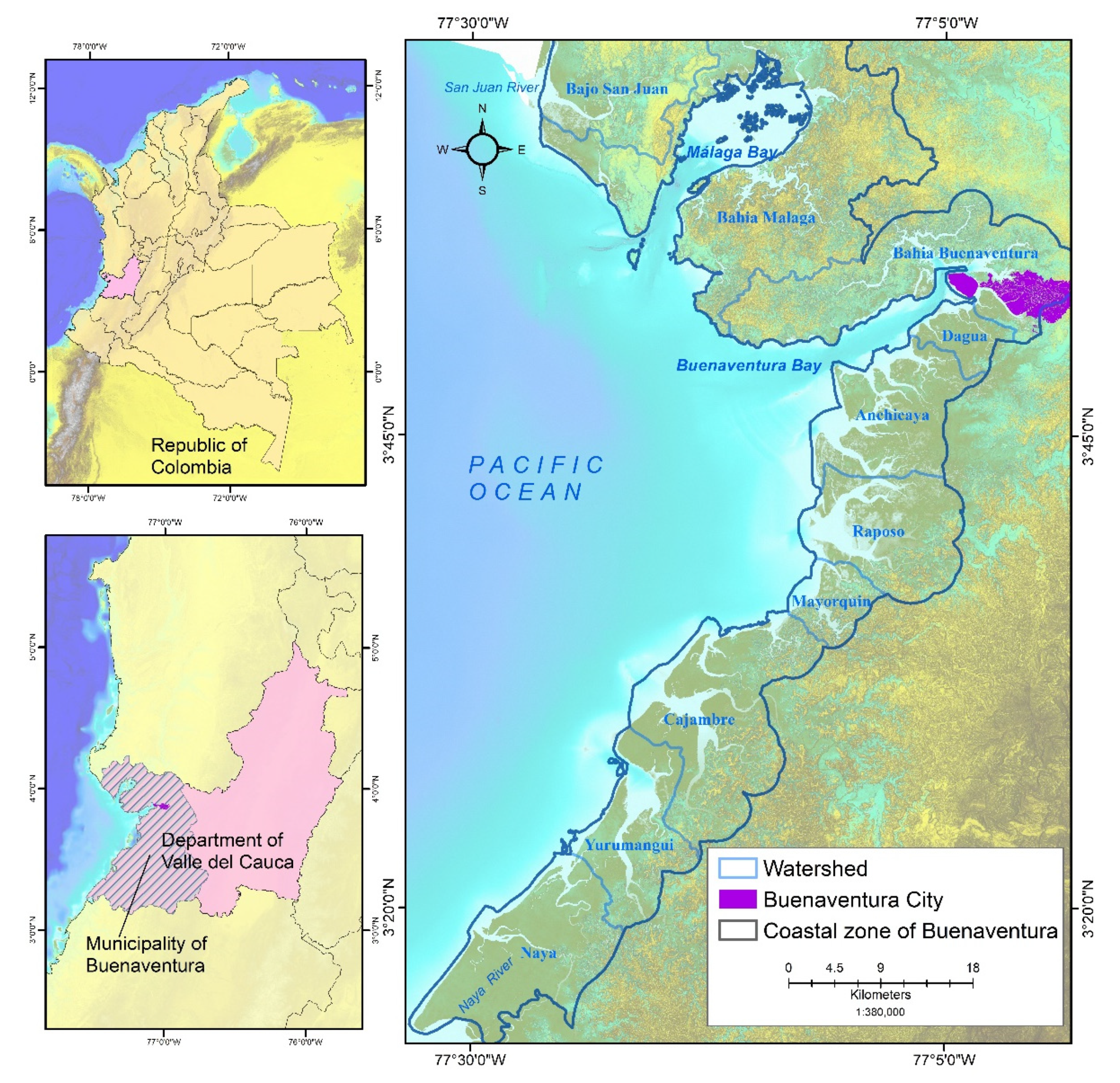
2.1. Study Area
2.2. Shoreline Change
2.3. Justification of the Indicators
2.4. Exposure Index (EI)
2.5. Sensitivity Index (SI)
2.6. Adaptive Capacity Index (ACI)
2.7. Composite Vulnerability Index (COVI)
3. Results
3.1. Rate of Coastline Displacement
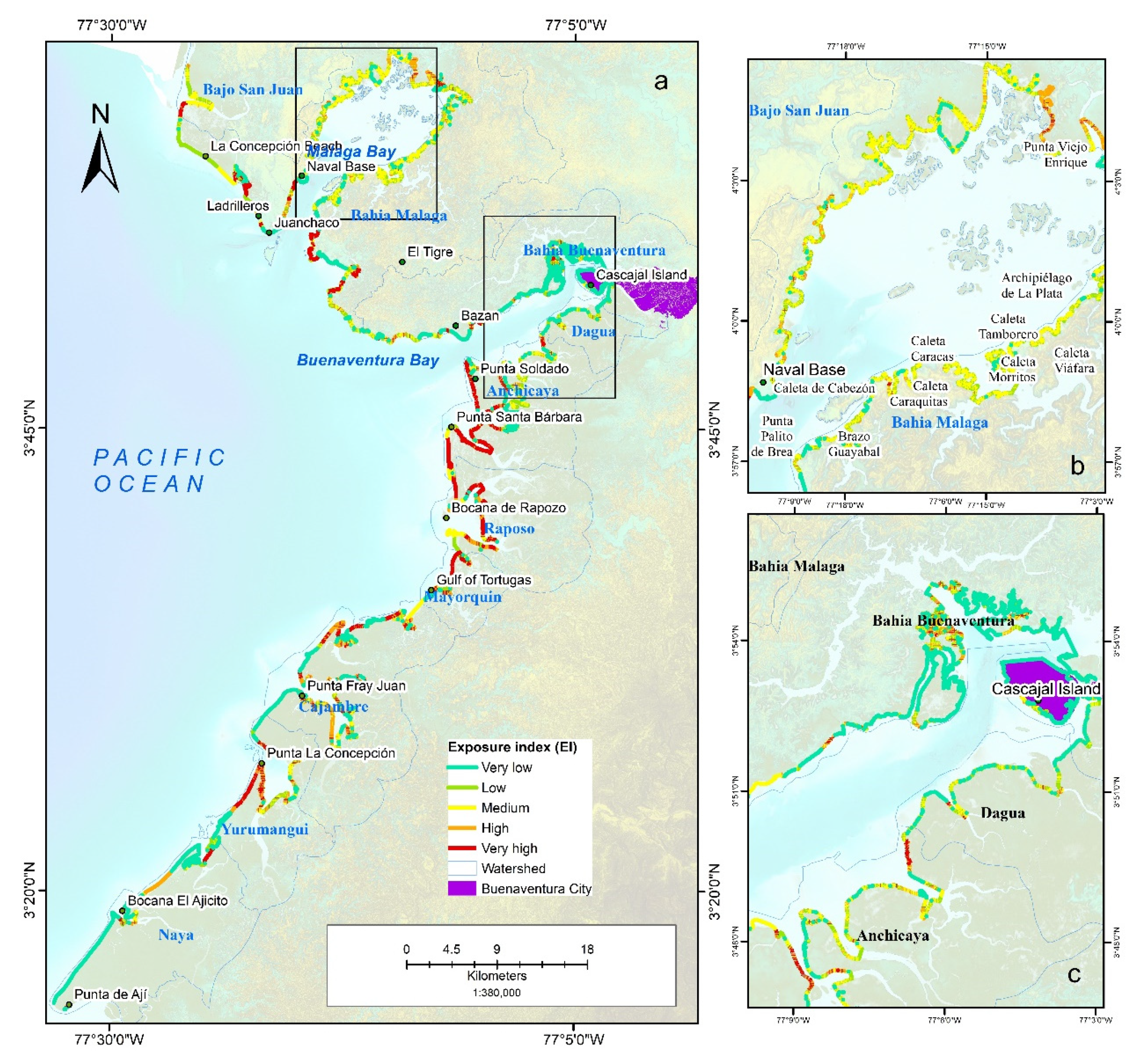
3.2. Exposure to Coastal Erosion
3.3. Sensitivity to Coastal Erosion
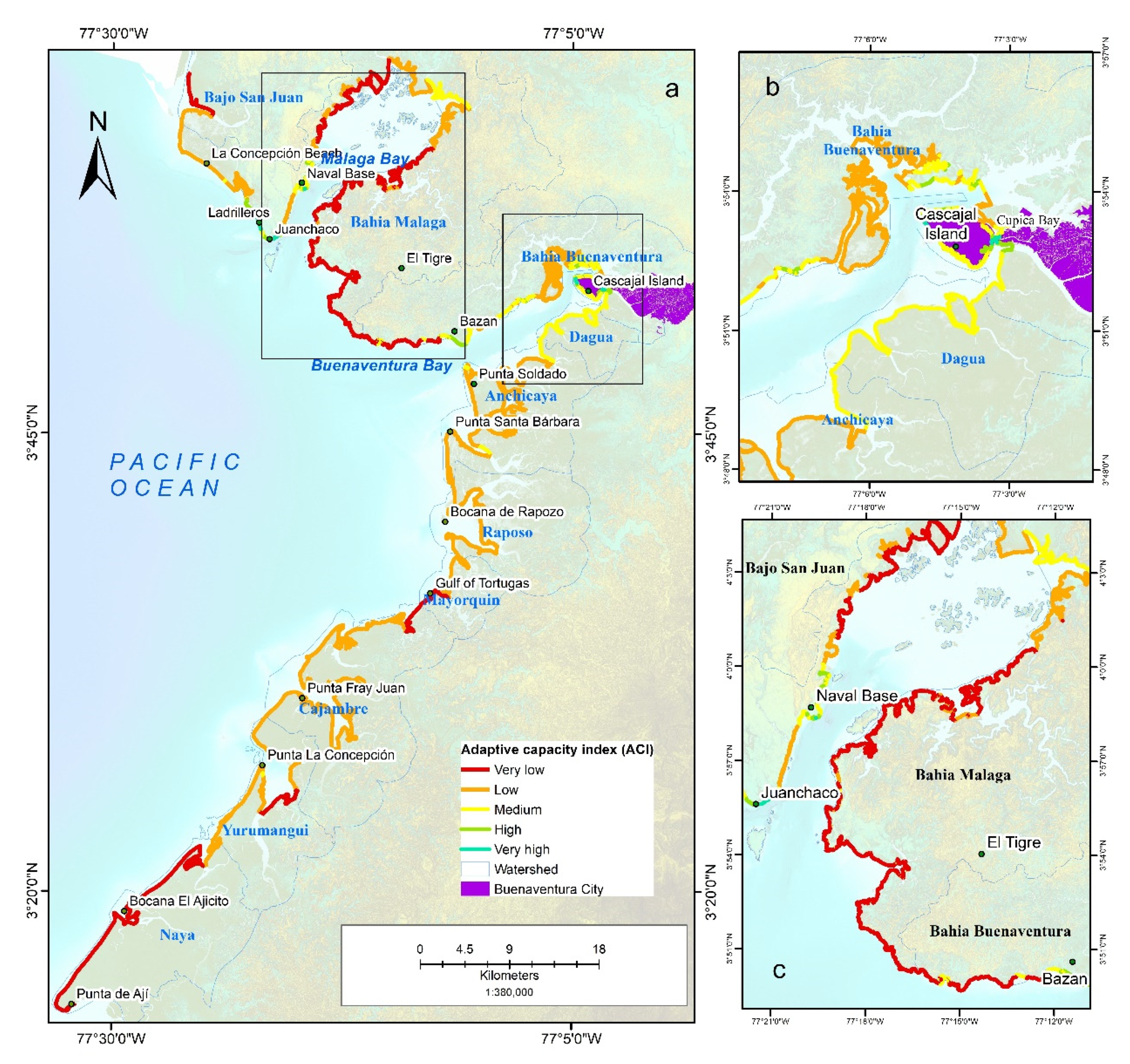
3.4. Adaptive Capacity to Coastal Erosion
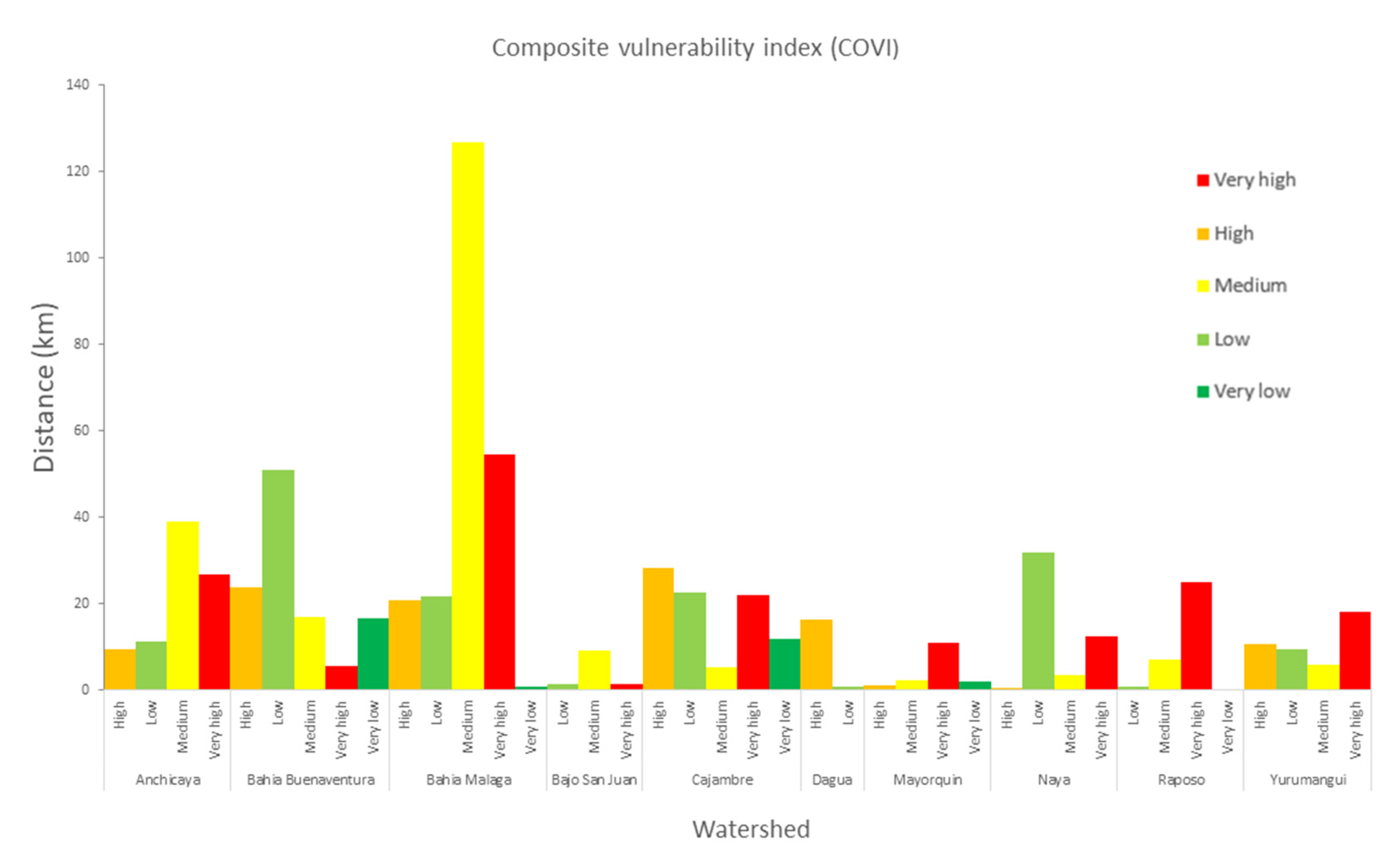
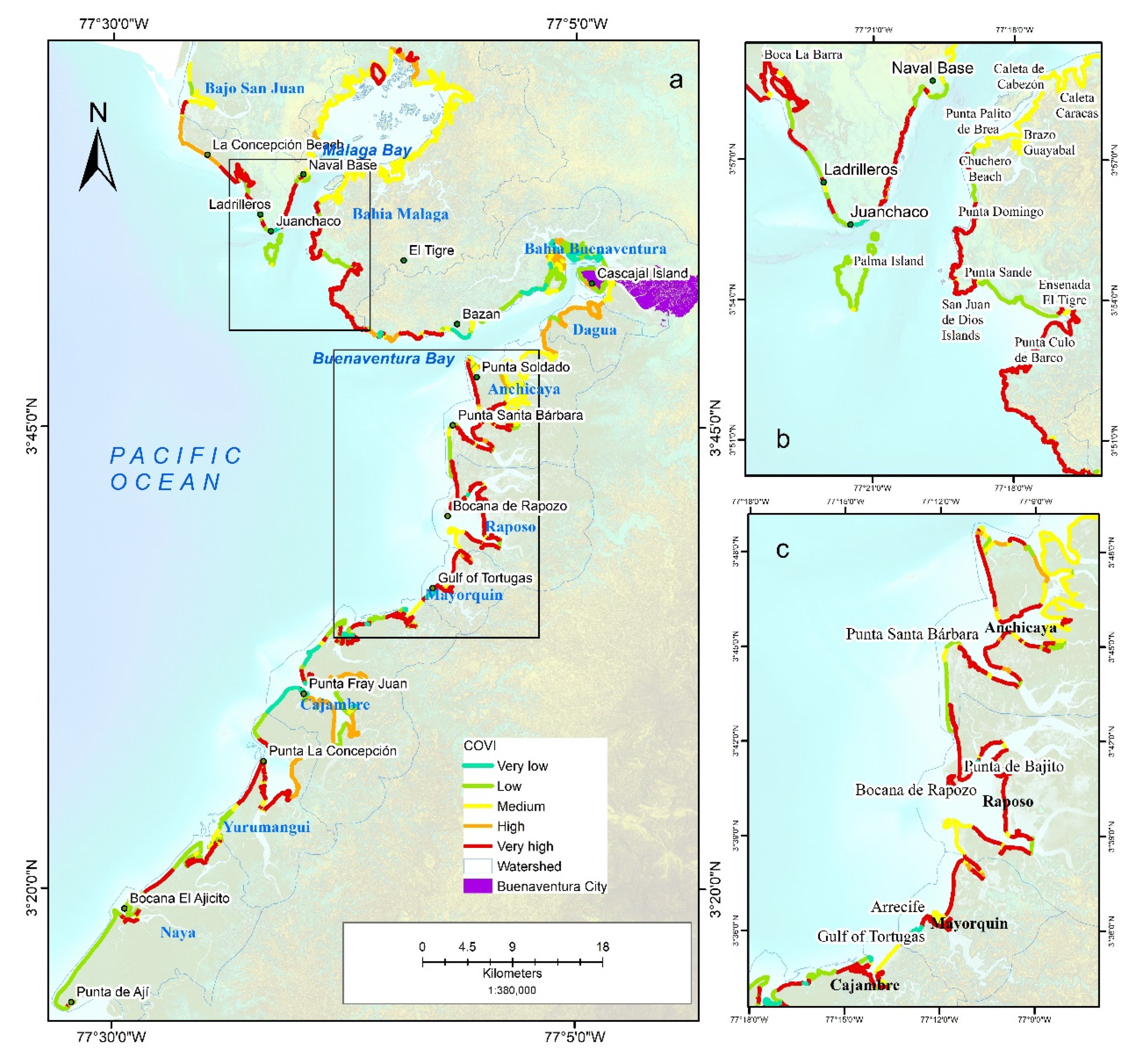
3.5. Results of the Composite Vulnerability Index
4. Discussion
5. Conclusions
Author Contributions
Funding
Institutional Review Board Statement
Informed Consent Statement
Data Availability Statement
Conflicts of Interest
References
- INVEMAR. Informe del Estado de los Ambientes y Recursos Marinos y Costeros en Colombia, 2019; Invemar: Santa Marta, Colombia, 2020; p. 183. [Google Scholar]
- Ricaurte Villota, C.; Gonzélez Arteaga, M.E.; Coca Dominguez, O.; Bejarano Espinosa, H.M.; Morales Giraldo, D.F.; Correa Rojas, C.X.; Briceño Zuluaga, F.; Legarda, G.; Arteaga, M. Amenaza y Vulnerabilidad por Erosión Costera en Colombia: Enfoque Regional para la Gestión del Riesgo; INVEMAR, Ed.; Instituto de Investigaciones Marinas y Costeras “José Benito Vives De Andréis”: Santa Marta, Colombia, 2018; Volume 33, p. 268. [Google Scholar]
- Gabler, C.A.; Osland, M.J.; Grace, J.B.; Stagg, C.L.; Day, R.H.; Hartley, S.B.; Enwright, N.M.; From, A.S.; McCoy, M.L.; McLeod, J.L. Macroclimatic change expected to transform coastal wetland ecosystems this century. Nat. Clim. Change 2017, 7, 142–147. [Google Scholar] [CrossRef]
- Richard, J.T.K.; Nicholls, R.J.; Sachooda, R.; Michele, C.; James, A.; Buckley, E.N. Technological Options for Adaptation to Climate Change in Coastal Zones. J. Coast. Res. 2001, 17, 531–543. [Google Scholar]
- Hermelin, M. Geomorphological Landscapes and Landforms of Colombia. In Landscapes and Landforms of Colombia; Hermelin, M., Ed.; Springer International Publishing: Cham, Switzerland, 2016; pp. 1–21. [Google Scholar] [CrossRef]
- Lichter, M.; Zviely, D.; Klein, M.; Sivan, D. Sea-Level Changes in the Mediterranean: Past, Present, and Future—A Review. In Seaweeds and their Role in Globally Changing Environments; Seckbach, J., Einav, R., Israel, A., Eds.; Springer: Dordrecht, The Netherlands, 2010; pp. 3–17. [Google Scholar] [CrossRef]
- Adger, W.N. Vulnerability. Glob. Environ. Change 2006, 16, 268–281. [Google Scholar] [CrossRef]
- Church, J.A.; Clark, P.U.; Cazenave, A.; Gregory, J.M.; Jevrejeva, S.; Levermann, A.; Merrifield, M.A.; Milne, G.A.; Nerem, R.S.; Nunn, P.D. Sea Level Change; PM Cambridge University Press: Cambridge, UK, 2013. [Google Scholar]
- Nicholls, R.J. Analysis of global impacts of sea-level rise: A case study of flooding. Phys. Chem. Earth Parts A/B/C 2002, 27, 1455–1466. [Google Scholar] [CrossRef]
- Pandey, B.W. Geoenvironmental Hazards in Himalaya: Assessment and Mapping (the Upper Beas Basin); Mittal Publications: New Delhi, India, 2002. [Google Scholar]
- Vogel, C.; O’Brien, K.J. Vulnerability and global environmental change: Rhetoric and reality. Aviso Inf. Bull. Glob. Environ. Change Hum. Secur. 2004, 13, 1–8. [Google Scholar]
- McCarthy, J.J.; Canziani, O.F.; Leary, N.A.; Dokken, D.J.; White, K.S. Climate Change 2001: Impacts, Adaptation, and Vulnerability: Contribution of Working Group II to the Third Assessment Report of the Intergovernmental Panel on Climate Change; Cambridge University Press: Cambridge, UK, 2001; Volume 2. [Google Scholar]
- Ricaurte-Villota, C.; Santamaría-del-Ángel, E.; Coca-Domínguez, O.; Morales Giraldo, D.; González-Arteaga, M. Determining factors of the hazard and vulnerability by coastal erosion in Colombia. Rev. Geográfica Chile Terra Aust. 2021, 1, 129–139. [Google Scholar] [CrossRef]
- Rozemeijer, M.J.C. Marine and Coastal Ecological Potential for the Economic Development of Colombia; IMARES: Yerseke, The Netherlands, 2013. [Google Scholar]
- Gornitz, V. Vulnerability of the East Coast, U.S.A. to Future Sea Level Rise. J. Coast. Res. 1990, 9, 201–237. [Google Scholar]
- Gornitz, V.; White, T.W.; Cushman, R.M. Vulnerability of the US to Future Sea Level Rise; Oak Ridge National Lab.: Oak Ridge, TN, USA, 1991. [Google Scholar]
- Gornitz, V.M.; Daniels, R.C.; White, T.W.; Birdwell, K.R. The Development of a Coastal Risk Assessment Database: Vulnerability to Sea-Level Rise in the U.S. Southeast. J. Coast. Res. 1994, 12, 327–338. [Google Scholar]
- Thieler, E.R.; Hammar-Klose, E.S. National Assessment of Coastal Vulnerability to Sea-Level Rise: Preliminary Results for the US Atlantic Coast; US Geological Survey: Reston, VA, USA, 1999. [Google Scholar]
- Bera, R.; Maiti, R. An assessment of coastal vulnerability using geospatial techniques. Environ. Earth Sci. 2021, 80, 306. [Google Scholar] [CrossRef]
- Coca-Domínguez, O.; Ricaurte-Villota, C. Validation of the Hazard and Vulnerability Analysis of Coastal Erosion in the Caribbean and Pacific Coast of Colombia. J. Mar. Sci. Eng. 2019, 7, 260. [Google Scholar] [CrossRef] [Green Version]
- Coca-Domínguez, O.; Ricaurte-Villota, C. Análisis de la evolución litoral y respuesta de las comunidades afro-descendientes asentadas en la zona costera: Caso de estudio La Barra, Buenaventura, Pacífico Colombiano. Entorno Geográfico 2019, 17, 7–26. [Google Scholar] [CrossRef]
- Gallego Perez, B.E.; Selvaraj, J.J. Evaluation of coastal vulnerability for the District of Buenaventura, Colombia: A geospatial approach. Remote Sens. Appl. Soc. Environ. 2019, 16, 100263. [Google Scholar] [CrossRef]
- Pramanik, M.K.; Dash, P.; Behal, D. Improving outcomes for socioeconomic variables with coastal vulnerability index under significant sea-level rise: An approach from Mumbai coasts. Environ. Dev. Sustain. 2021, 23, 13819–13853. [Google Scholar] [CrossRef]
- Serafim, M.B.; Siegle, E.; Corsi, A.C.; Bonetti, J. Coastal vulnerability to wave impacts using a multi-criteria index: Santa Catarina (Brazil). J. Environ. Manag. 2019, 230, 21–32. [Google Scholar] [CrossRef]
- Arkema, K.K.; Guannel, G.; Verutes, G.; Wood, S.A.; Guerry, A.; Ruckelshaus, M.; Kareiva, P.; Lacayo, M.; Silver, J.M. Coastal habitats shield people and property from sea-level rise and storms. Nat. Clim. Change 2013, 3, 913–918. [Google Scholar] [CrossRef]
- Klein, R.J.; Midglev, G.; Preston, B.; Alam, M.; Berkhout, F.; Dow, K.; Shaw, M. Climate Change 2014: Impacts, Adaptation, and Vulnerability; IPCC Fifth Assessment Report; IPCC: Stockholm, Sweden, 2014. [Google Scholar]
- Zhang, Y.; Wu, T.; Arkema, K.K.; Han, B.; Lu, F.; Ruckelshaus, M.; Ouyang, Z. Coastal vulnerability to climate change in China’s Bohai Economic Rim. Environ. Int. 2021, 147, 106359. [Google Scholar] [CrossRef]
- Ghosh, S.; Mistri, B. Assessing coastal vulnerability to environmental hazards of Indian Sundarban delta using multi-criteria decision-making approaches. Ocean Coast. Manag. 2021, 209, 105641. [Google Scholar] [CrossRef]
- Sahana, M.; Sajjad, H. Vulnerability to storm surge flood using remote sensing and GIS techniques: A study on Sundarban Biosphere Reserve, India. Remote Sens. Appl. Soc. Environ. 2019, 13, 106–120. [Google Scholar] [CrossRef]
- Furlan, E.; Pozza, P.D.; Michetti, M.; Torresan, S.; Critto, A.; Marcomini, A. Development of a Multi-Dimensional Coastal Vulnerability Index: Assessing vulnerability to inundation scenarios in the Italian coast. Sci. Total Environ. 2021, 772, 144650. [Google Scholar] [CrossRef]
- Cifuentes-Ossa, M.A.; Rosero-Henao, L.V.; Josephraj-Selvaraj, J. Detección de cambios de la línea costera al norte del distrito de Buenaventura mediante el uso de sensores remotos. Boletín Investig. Mar. Costeras—INVEMAR 2017, 46, 137–152. [Google Scholar] [CrossRef]
- Uribe-Castañeda, N.; Satizabal, C.A.; Herrera-Orozco, L.; Cantera Kintz, J.R. Vulnerabilidad de los servicios ecosistémicos del área marina protegida Uramba. Boletín Investig. Mar. Costeras 2020, 49, 95–118. [Google Scholar] [CrossRef]
- Abdelaty, E.F. Coastal Erosion Assessment of the Nile Delta Coast using Remote Sensing, GIS, and Modified Coastal Vulnerability Index. Alex. Sci. Exch. J. 2021, 42, 645–655. [Google Scholar] [CrossRef]
- Boumboulis, V.; Apostolopoulos, D.; Depountis, N.; Nikolakopoulos, K. The Importance of Geotechnical Evaluation and Shoreline Evolution in Coastal Vulnerability Index Calculations. J. Mar. Sci. Eng. 2021, 9, 0423. [Google Scholar] [CrossRef]
- Sekovski, I.; Del Río, L.; Armaroli, C. Development of a coastal vulnerability index using analytical hierarchy process and application to Ravenna province (Italy). Ocean Coast. Manag. 2020, 183, 104982. [Google Scholar] [CrossRef]
- Koroglu, A.; Ranasinghe, R.; Jiménez, J.A.; Dastgheib, A. Comparison of Coastal Vulnerability Index applications for Barcelona Province. Ocean Coast. Manag. 2019, 178, 104799. [Google Scholar] [CrossRef]
- Mohd, F.A.; Abdul Maulud, K.N.; Karim, O.A.; Begum, R.A.; Awang, N.A.; Ahmad, A.; Wan Mohamed Azhary, W.A.H.; Kamarudin, M.K.A.; Jaafar, M.; Wan Mohtar, W.H.M. Comprehensive coastal vulnerability assessment and adaptation for Cherating-Pekan coast, Pahang, Malaysia. Ocean Coast. Manag. 2019, 182, 104948. [Google Scholar] [CrossRef]
- Hoque, M.A.-A.; Ahmed, N.; Pradhan, B.; Roy, S. Assessment of coastal vulnerability to multi-hazardous events using geospatial techniques along the eastern coast of Bangladesh. Ocean Coast. Manag. 2019, 181, 104898. [Google Scholar] [CrossRef]
- Hzami, A.; Heggy, E.; Amrouni, O.; Mahé, G.; Maanan, M.; Abdeljaouad, S. Alarming coastal vulnerability of the deltaic and sandy beaches of North Africa. Sci. Rep. 2021, 11, 2320. [Google Scholar] [CrossRef]
- Rehman, S.; Sahana, M.; Kumar, P.; Ahmed, R.; Sajjad, H. Assessing hazards induced vulnerability in coastal districts of India using site-specific indicators: An integrated approach. GeoJournal 2021, 86, 2245–2266. [Google Scholar] [CrossRef]
- Mullick, M.R.A.; Tanim, A.H.; Islam, S.M.S. Coastal vulnerability analysis of Bangladesh coast using fuzzy logic based geospatial techniques. Ocean Coast. Manag. 2019, 174, 154–169. [Google Scholar] [CrossRef]
- Casanova Rosero, R.F.; Zambrano Ortiz, M.M.; Velasco Vinasco, E.; Rodríguez Cuitiva, D.E.; Escobar Olaya, G.A.; Narváez Flórez, S.; Bautista Duarte, P.; Betancourt Portela, J.M.; Parra, J.P. Panorama de la Contaminación del Marina del Pacífico Colombiano, 2005–2010; Dirección General Marítima: Bogota, Colombia, 2012. [Google Scholar]
- Castellanos-Galindo, G.A.; Krumme, U.; Rubio, E.A.; Saint-Paul, U. Spatial variability of mangrove fish assemblage composition in the tropical eastern Pacific Ocean. Rev. Fish Biol. Fish. 2013, 23, 69–86. [Google Scholar] [CrossRef]
- INVEMAR. Informe del Estado de los Ambientes y Recursos Marinos y Costeros en Colombia, 2011; Invemar: Santa Marta, Colombia, 2012; Volume 8, p. 203. [Google Scholar]
- Posada Posada, B.O.; Henao Pineda, W.; Guzmán Ospitia, G. Diagnóstico de la Erosión y Sedimentación en la Zona Costera del Pacífico Colombiano; Instituto de Investigaciones Marinas y Costeras—INVEMAR: Santa Marta, Colombia, 2009. [Google Scholar]
- Vega, L.; Cantillo, V.; Arellana, J. Assessing the impact of major infrastructure projects on port choice decision: The Colombian case. Transp. Res. Part A Policy Pract. 2019, 120, 132–148. [Google Scholar] [CrossRef]
- Comovamos, B. Informe de Calidad de Vida de Buenaventura 2019–2020; Buenaventura Comovamos: Buenaventura, Colombia, 2021; p. 84. [Google Scholar]
- DANE. Censo Nacional de Población y Vivienda (CNPV). 2018. Available online: https://www.dane.gov.co/index.php/estadisticas-por-tema/demografia-y-poblacion/censo-nacional-de-poblacion-y-vivenda-2018 (accessed on 24 January 2021).
- Fletcher, C.; Rooney, J.; Barbee, M.; Lim, S.-C.; Richmond, B. Mapping Shoreline Change Using Digital Orthophotogrammetry on Maui, Hawaii. J. Coast. Res. 2003, 38, 106–124. [Google Scholar]
- Rangel-Buitrago, N.; Neal, W.J.; de Jonge, V.N. Risk assessment as tool for coastal erosion management. Ocean Coast. Manag. 2020, 186, 105099. [Google Scholar] [CrossRef]
- Inc, P.L. Specification, Planet Imagery Product; Planet Labs Inc.: San Francisco, CA, USA, 2020; p. 97. [Google Scholar]
- White, K.; El Asmar, H.M. Monitoring changing position of coastlines using Thematic Mapper imagery, an example from the Nile Delta. Geomorphology 1999, 29, 93–105. [Google Scholar] [CrossRef]
- Mareas, T.d. Tabla de Mareas, Valle del Cauca—Buenaventura. Available online: https://tablademareas.com/co/valle-del-cauca/buenaventura (accessed on 10 July 2021).
- Oyedotun, T.D. Shoreline geometry: DSAS as a tool for historical trend analysis. Geomorphol. Tech. 2014, 3, 1–12. [Google Scholar]
- Hahn, M.B.; Riederer, A.M.; Foster, S.O. The Livelihood Vulnerability Index: A pragmatic approach to assessing risks from climate variability and change—A case study in Mozambique. Glob. Environ. Change 2009, 19, 74–88. [Google Scholar] [CrossRef]
- López Royo, M.; Ranasinghe, R.; Jiménez, J.A. A Rapid, Low-Cost Approach to Coastal Vulnerability Assessment at a National Level. J. Coast. Res. 2016, 32, 932–945. [Google Scholar] [CrossRef]
- Álvarez, M.C.; Bermúdez-Rivas, C.; Niño, D.C. Caracterización de la geomorfología costera y sus coberturas vegetales asociadas, a través de sensores remotos en la Bahía de Buenaventura, Valle del Cauca. Boletín Científico CIOH 2016, 34, 49–63. [Google Scholar] [CrossRef]
- Reuter, H.I.; Hengl, T.; Gessler, P.; Soille, P. Chapter 4 Preparation of DEMs for Geomorphometric Analysis. In Developments in Soil Science; Hengl, T., Reuter, H.I., Eds.; Elsevier: Amsterdam, The Netherlands, 2009; Volume 33, pp. 87–120. [Google Scholar]
- Ashraful Islam, M.; Mitra, D.; Dewan, A.; Akhter, S.H. Coastal multi-hazard vulnerability assessment along the Ganges deltaic coast of Bangladesh—A geospatial approach. Ocean Coast. Manag. 2016, 127, 1–15. [Google Scholar] [CrossRef]
- CMEMS. Sea Level Daily Gridded Data from Satellite Observations for the Global Ocean from 1993 to Present. Available online: https://cds.climate.copernicus.eu/cdsapp#!/dataset/satellite-sea-level-global?tab=overview (accessed on 5 May 2021).
- ECMWF. ERA5 Monthly Averaged Data on Single Levels from 1959 to Present. Available online: https://cds.climate.copernicus.eu/cdsapp#!/dataset/reanalysis-era5-single-levels-monthly-means?tab=overview (accessed on 5 May 2021).
- Gisbert, F.J.G.; Martí, I.C. Rugosidad del terreno: Una característica del paisaje poco estudiada. Doc. Trab. 2010, 10, 1. [Google Scholar]
- Saaty, T.L. The Analytic Hierarchy and Analytic Network Processes for the Measurement of Intangible Criteria and for Decision-Making. In Multiple Criteria Decision Analysis: State of the Art Surveys; Greco, S., Ehrgott, M., Figueira, J.R., Eds.; Springer: New York, NY, USA, 2016; pp. 363–419. [Google Scholar] [CrossRef]
- Alkire, S.; Foster, J. Counting and multidimensional poverty measurement. J. Public Econ. 2011, 95, 476–487. [Google Scholar] [CrossRef]
- Angulo Salazar, R.C.; Díaz Cuervo, Y.; Pardo Pinzón, R. Índice de pobreza multidimensional para Colombia (IPM-Colombia). Arch. Econ. 2011, 382, 1997–2010. [Google Scholar]
- IDEAM. Leyenda Nacional de Coberturas de la Tierra: Metodología CORINE Land Cover Adaptada para Colombia: Escala 1:100.000; Ideam: Bogota, Colombia, 2010. [Google Scholar]


| Index | Tools * | Year | Country | Author |
|---|---|---|---|---|
| Coastal Vulnerability Index (CVI) | GIS, RS, DSAS | 2021 | India | Bera and Maiti, 2021 [19] |
| GIS, RS, DSAS | 2021 | India | Pramanik et al., 2021 [23] | |
| GIS, RS, DSAS | 2021 | Egypt | Abdelaty, 2021 [33] | |
| GIS, RS, DSAS | 2021 | Greece | Boumboulis et al., 2021 [34] | |
| GIS, RS, DSAS | 2020 | Italy | Sekovskia et al., 2020 [35] | |
| GIS | 2019 | Brazil | Serafim et al., 2019 [24] | |
| GIS | 2019 | Spain | Koroglua et al.,2019 [36] | |
| GIS | 2019 | Malaysia | Mohda et al.,2019 [37] | |
| GIS, RS, DSAS | 2019 | Bangladesh | Hoquea et al., 2019 [38] | |
| GIS | 2019 | Colombia | Coca and Ricaute, 2019 [21] | |
| GIS, RS, DSAS | 2019 | Colombia | Gallego and Selvaraj, 2019 [22] | |
| Composite Vulnerability Index (COVI) | GIS, RS, DSAS | 2021 | Tunisia | Hzami et al., 2021 [39] |
| GIS | 2021 | China | Zhang et al., 2021 [27] | |
| GIS | 2021 | India | Ghosh and Mistri 2021 [28] | |
| GIS | 2021 | Italy | Furlan et al., 2021 [30] | |
| GIS | 2020 | India | Rehman et al., 2020 [40] | |
| GIS | 2020 | India | Sahana and Sajjad,2019 [29] | |
| GIS, RS, DSAS | 2019 | Bangladesh | Mullick et al., 2019 [41] |
| Year | Sensor | Product * | Spatial Resolution | Source |
|---|---|---|---|---|
| 1986 | Aerial photography | Orthomosaic | 3 m | Geographic Institute of Colombia (IGAC) |
| 2009 | Synthetic-Aperture Radar Image—Airborne | Orthomosaic, DSM, DTM | 3 m | Geographic Institute of Colombia (IGAC) |
| 2015 | Synthetic-Aperture Radar Image—Airborne | Orthomosaic, DSM, DTM | 3 m | Regional Autonomous Corporation of Valle del Cauca (CVC) |
| 2020 | Satellite PlanetScope | Orthomosaic | 3 m | This project |
| Components | Indicators | Class | Range |
|---|---|---|---|
| Exposure | Geomorphology | Barrier island, Flood plain, Intertidal flat without vegetation, Beach | 5—Very High |
| vegetated intertidal flat | 4—High | ||
| Alluvial valley | 3—Moderate | ||
| Island | 2—Low | ||
| Water body, Coastal lagoon, Hillocks and hills, Continental shelf, Marine terrace | 1—Very Low | ||
| Slope | 0–18° | 5—Very High | |
| (degrees) | 18–25° | 4—High | |
| 25–75° | 3—Moderate | ||
| 75–80° | 2—Low | ||
| 80–88° | 1—Very Low | ||
| Shoreline change rate | −96.30 to −3.0 | 5—Very High | |
| (m/year) | −2.99 to 0.5 | 4—High | |
| −0.49 to 0.5 | 3—Moderate | ||
| 0.51 to 3.0 | 2—Low | ||
| 3.1 to 95.9 | 1—Very Low | ||
| Sea level rise rate | >9 | 5—Very High | |
| (mm/year) | 6 to 9 | 4—High | |
| 3.9 to 6 | 3—Moderate | ||
| 0 to 3.9 | 2—Low | ||
| <0 | 1—Very Low | ||
| Mean tidal range | 3.0 to 3.74 | 5—Very High | |
| (m) | 2.25 to 2.99 | 4—High | |
| 1.26 to 2.24 | 3—Moderate | ||
| 0.38 to 0.75 | 2—Low | ||
| 0.26 to 0.38 | 1—Very Low | ||
| Significant wave height | >6 | 5—Very High | |
| (m) | 4 to 6 | 4—High | |
| 2 to 4 | 3—Moderate | ||
| 1 to 2 | 2—Low | ||
| <1.0 | 1—Very Low | ||
| Flood inundation risk | ENSO floods | 5—Very High | |
| Hydrometeorological flooding | 4—High | ||
| Roughness of terrain | 0.131 (Very rough) | 5—Very High | |
| 0.128 (Rough) | 4—High | ||
| 0.047 (Roughly open) | 3—Moderate | ||
| 0.020 (Open) | 2—Low | ||
| 0.001 (Smooth) | 1—Very Low | ||
| Sensitivity | Multidimensional poverty | 70.1% to 98.5% | 5—Very High |
| 50.1% to 70% | 4—High | ||
| 40.1% to 50% | 3—Moderate | ||
| 30.1% to 40% | 2—Low | ||
| 4.15% to 30% | 1—Very Low | ||
| Settlements | Urbanized area | 5—Very high | |
| Villages | 4—High | ||
| Rural | 3—Medium | ||
| No settlement | 2—Low | ||
| Land Use and Land Cover | Urban zones, Artificial surfaces | 5—Very High | |
| Cultivation areas, Banana, Coconut palm, Miscellaneous | 4—High | ||
| Shrubland, Guandal forest, Mangrove Forest, Mixed Forest, Natural grassland, Island, Cultivated grassland, Secondary vegetation | 3—Moderate | ||
| Temporary flooded areas, Natural areas, Other marshy areas | 2—Low | ||
| Shallows and intertidal flats, Littoral barriers, Artificial ponds, Ocean, Beaches, Rivers | 1—Very Low | ||
| Population (inhabitant/km2) | 80 to 20,656 | 5—Very High | |
| 50 to 80 | 4—High | ||
| 15 to 50 | 3—Moderate | ||
| 5 to15 | 2—Low | ||
| 1 to 5 | 1—Very Low | ||
| Adaptive capacity | Economic activities | Industrial fishing | 5—Very High |
| Artisanal fishing | 4—High | ||
| Ecotourism | 3—Moderate | ||
| Landscape | 2—Low | ||
| Recreation—beaches | 1—Very Low | ||
| Medical services (Health care provided) | 0 to 56 | 5—Very High | |
| 57 to179 | 4—High | ||
| 180 to 327 | 3—Moderate | ||
| 328 to 628 | 2—Low | ||
| 629 to 1186 | 1—Very Low | ||
| Distance to roads | 2000 m | 5—Very High | |
| 1000 m | 4—High | ||
| 500 m | 3—Moderate | ||
| 250 m | 2—Low | ||
| 100 m | 1—Very Low | ||
| Literacy rate | <67% | 5—Very High | |
| 67% to 73% | 4—High | ||
| 73% to 81% | 3—Moderate | ||
| 81% to 86% | 2—Low | ||
| >86% | 1—Very Low |
| State | Watershed | km | Location | km |
|---|---|---|---|---|
| Erosion | Anchicaya | 19.96 | Punta Soldado, Punta Santa Barbara | 18.27 |
| Cajambre | 12.22 | Punta Bonita | 12.22 | |
| Yurumangui | 9.52 | Punta La Concepción | 8.31 | |
| Bajo San Juan | 9.16 | El Choncho | 6.87 | |
| Naya | 7.50 | El Ajicito beach | 4.7 | |
| Malaga Bay | 7.27 | The Bar | 6.05 | |
| Accretion | Naya | 35.35 | Ajicito and Ají beach | 32.09 |
| Malaga Bay | 32.83 | La Concepción Beach | 20.1 | |
| Bajo San Juan | 27.27 | Boca de Bajo San Juan | 20.08 | |
| Cajambre | 21.57 | Punta Fray Juan | 20.73 | |
| Raposo | 15.65 | Raposo mouth | 15.29 |
Publisher’s Note: MDPI stays neutral with regard to jurisdictional claims in published maps and institutional affiliations. |
© 2022 by the authors. Licensee MDPI, Basel, Switzerland. This article is an open access article distributed under the terms and conditions of the Creative Commons Attribution (CC BY) license (https://creativecommons.org/licenses/by/4.0/).
Share and Cite
Fuentes, J.E.; Olaya, R.A.; Garcia, C.E. Evaluation of Coastal Erosion in the Watersheds of Municipality of Buenaventura, Colombia: Using Geospatial Techniques and the Composite Vulnerability Index. ISPRS Int. J. Geo-Inf. 2022, 11, 568. https://doi.org/10.3390/ijgi11110568
Fuentes JE, Olaya RA, Garcia CE. Evaluation of Coastal Erosion in the Watersheds of Municipality of Buenaventura, Colombia: Using Geospatial Techniques and the Composite Vulnerability Index. ISPRS International Journal of Geo-Information. 2022; 11(11):568. https://doi.org/10.3390/ijgi11110568
Chicago/Turabian StyleFuentes, Jose Eduardo, Robin Alexis Olaya, and Cesar Edwin Garcia. 2022. "Evaluation of Coastal Erosion in the Watersheds of Municipality of Buenaventura, Colombia: Using Geospatial Techniques and the Composite Vulnerability Index" ISPRS International Journal of Geo-Information 11, no. 11: 568. https://doi.org/10.3390/ijgi11110568
APA StyleFuentes, J. E., Olaya, R. A., & Garcia, C. E. (2022). Evaluation of Coastal Erosion in the Watersheds of Municipality of Buenaventura, Colombia: Using Geospatial Techniques and the Composite Vulnerability Index. ISPRS International Journal of Geo-Information, 11(11), 568. https://doi.org/10.3390/ijgi11110568