
Application-Based COVID-19 Micro-Mobility Solution for Safe and Smart Navigation in Pandemics


Abstract
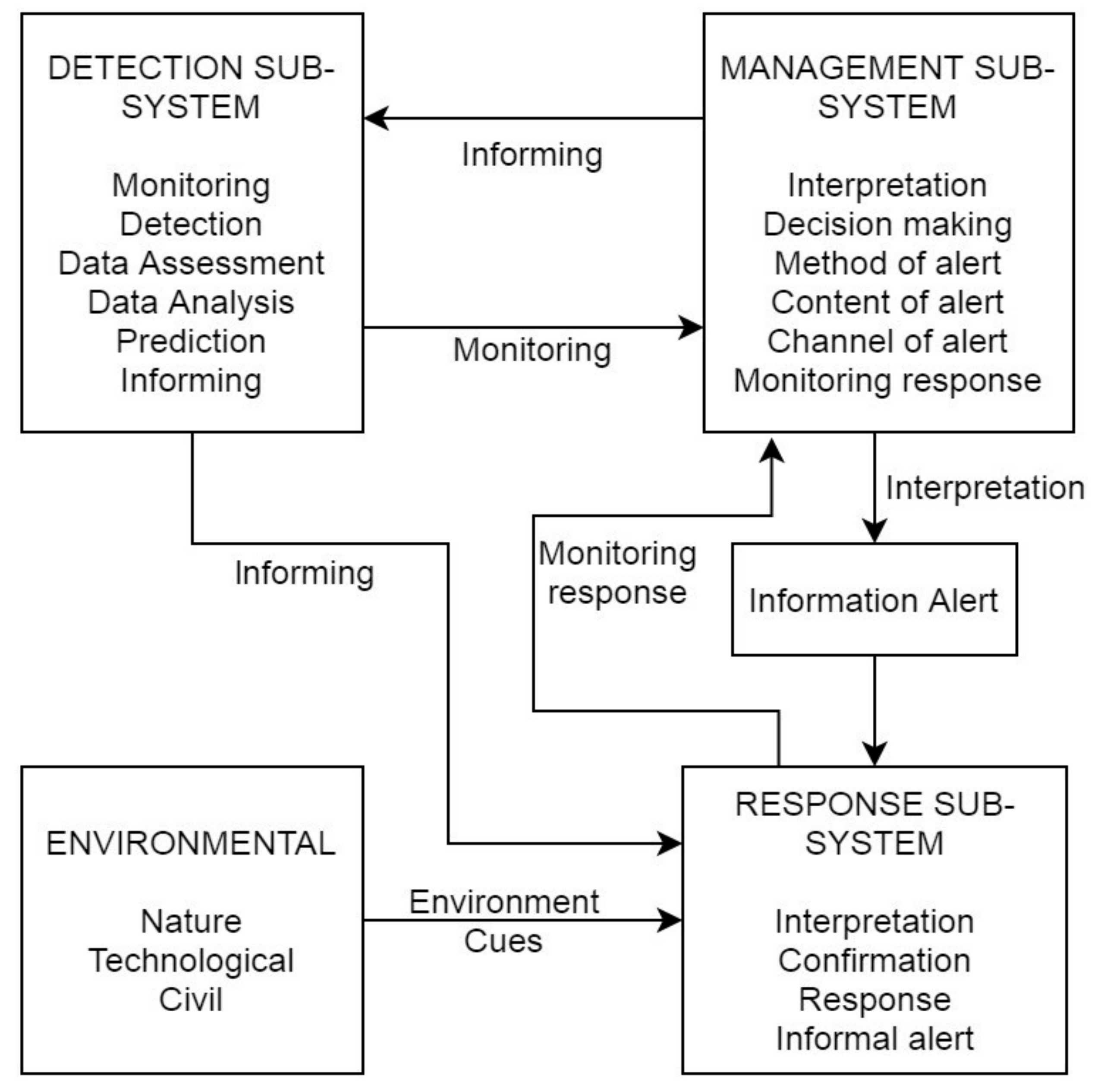
:1. Introduction
2. Background Theory and Data Usage
2.1. Geospatial Analysis of Road Network
2.2. Geospatial Data and Frameworks
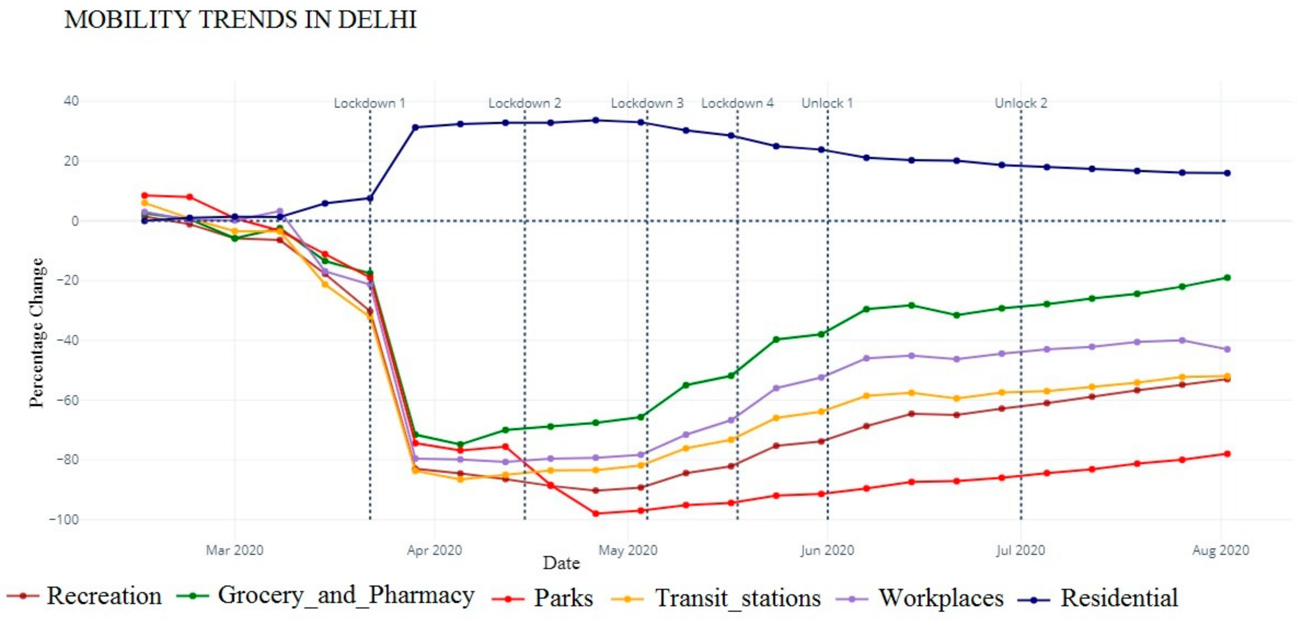
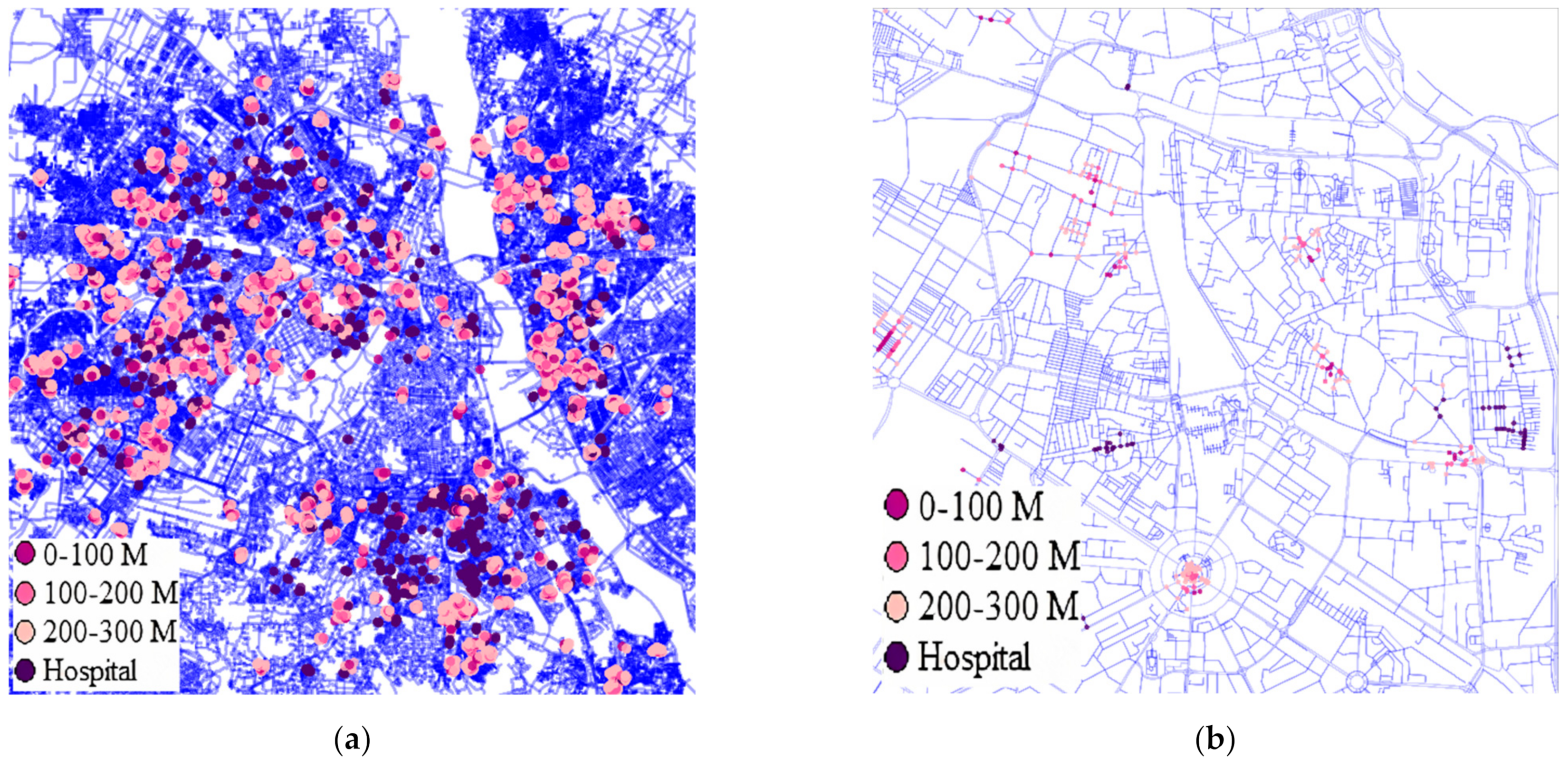
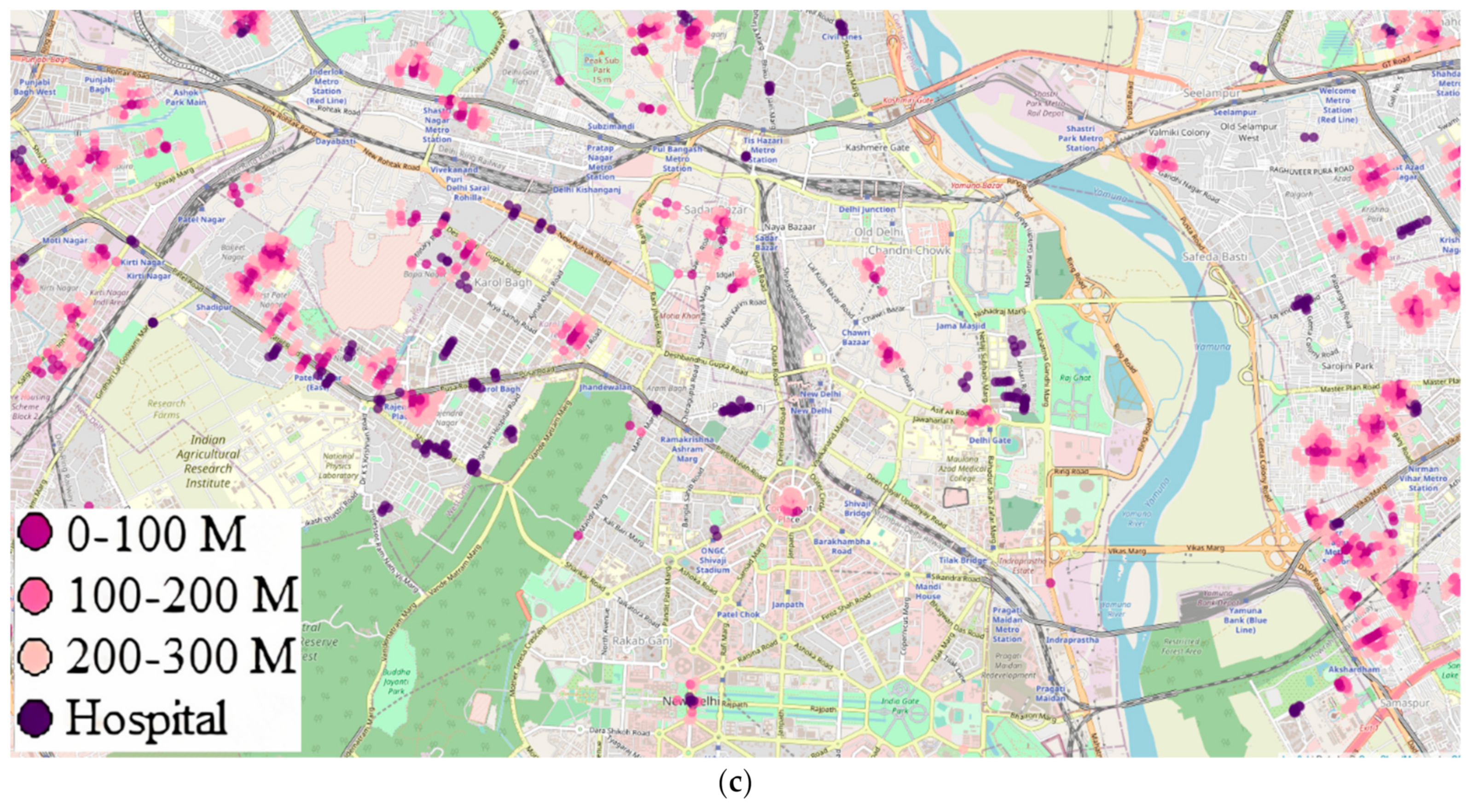
2.3. Regional Containment Zones and Medical Facilities Data
2.4. Map Visualization
2.5. Traffic Flow and Betweenness Centrality (BC)
2.6. Problem Scope and Objectives
3. Methodology
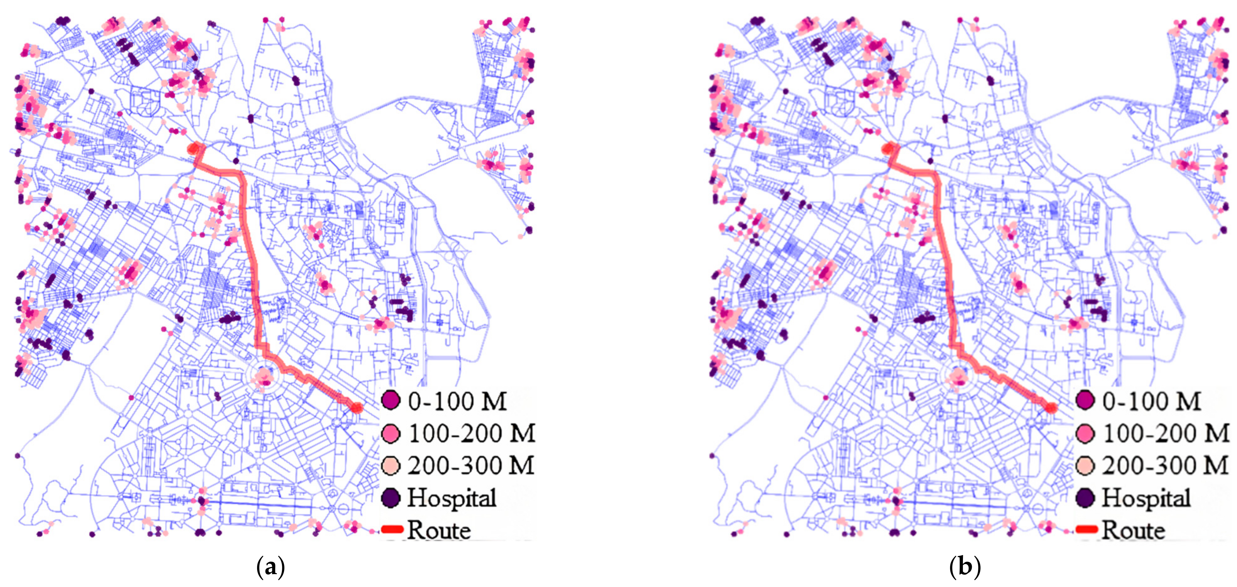
3.1. Visualizations and Rerouting Methodology
3.2. Design Criteria for Route Planning
3.3. Cost Function Discussion
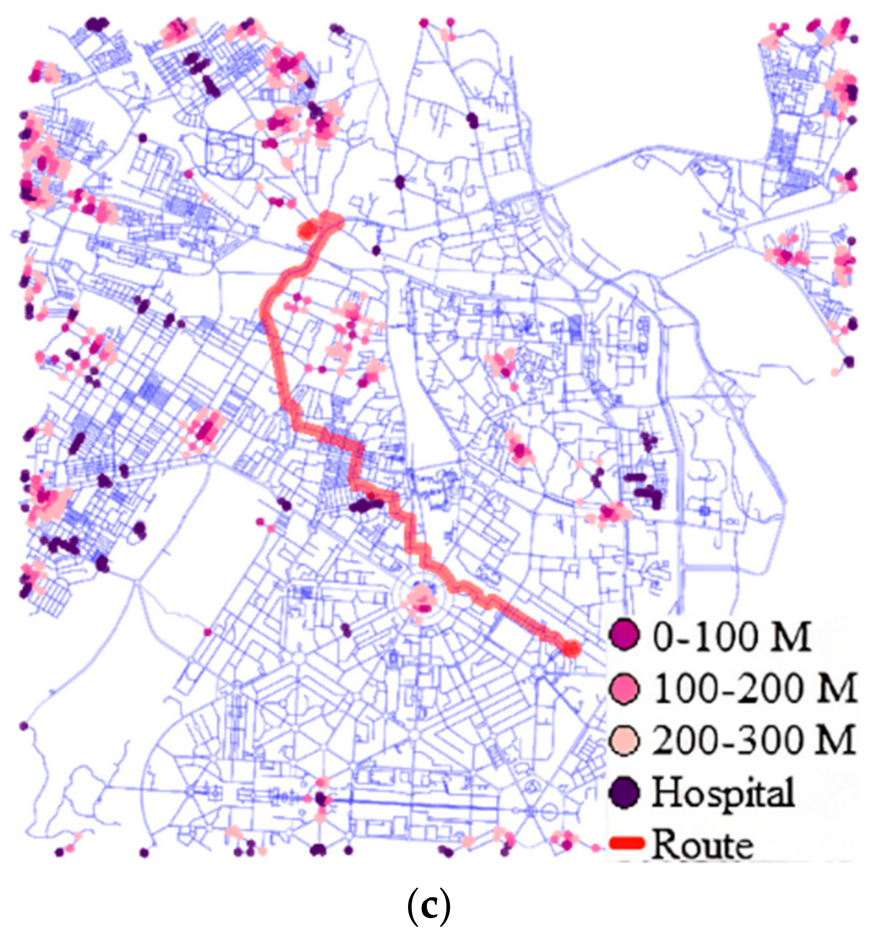
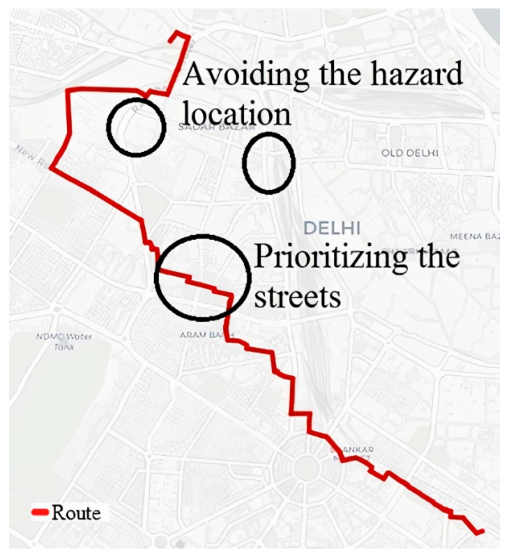
4. Route Case Study and Results
5. Policy Implications
6. Discussions and Future Scope
6.1. Limitations of Weight Allocation and Mobile Source Data Availability
6.2. Direction for Moving Source Info by Contact Tracing and Limitation Due to Privacy
7. Conclusions
Author Contributions
Funding
Institutional Review Board Statement
Acknowledgments
Conflicts of Interest
References
- Gatalo, O.; Tseng, K.; Hamilton, A.; Lin, G.; Klein, E. Associations between phone mobility data and COVID-19 cases. Lancet Infect. Dis. 2021, 21, e111. [Google Scholar] [CrossRef]
- Li, A.; Zhao, P.; He, H.; Axhausen, K.W. Understanding the Variations of Micromobility Behavior before and During COVID-19 Pandemic Period. Arbeitsberichte Verkehrsund Raumplanung. 2020, Volume 1547, IVT, ETH Zurich. Available online: https://www.research-collection.ethz.ch:443/handle/20.500.11850/430395 (accessed on 14 July 2021).
- Aloi, A.; Alonso, B.; Benavente, J.; Cordera, R.; Echániz, E.; González, F.; Ladisa, C.; Lezama-Romanelli, R.; López-Parra, Á.; Mazzei, V.; et al. Effects of the COVID-19 Lockdown on Urban Mobility: Empirical Evidence from the City of Santander (Spain). Sustainability 2020, 12, 3870. [Google Scholar] [CrossRef]
- Martellucci, C.A.; Sah, R.; Rabaan, A.A.; Dhama, K.; Casalone, C.; Arteaga-Livias, K.; Sawano, T.; Ozaki, A.; Bhandari, D.; Higuchi, A.; et al. Changes in the spatial dis-tribution of COVID-19 incidence in Italy using GIS-based maps. Ann. Clin. Microbiol. Antimicrob. 2020, 19, 1–4. [Google Scholar] [CrossRef]
- Khanal, L.; Paudel, B.K.; Acharya, B.K. Community vulnerability to epidemics in Nepal A high-resolution spatial assessment amidst COVID-19 pandemic. Nepal. J. Zool. 2020, 4, 23–35. [Google Scholar] [CrossRef]
- Ramírez, I.J.; Lee, J. COVID-19 Emergence and Social and Health Determinants in Colorado: A Rapid Spatial Analysis. Int. J. Environ. Res. Public Health 2020, 17, 3856. [Google Scholar] [CrossRef] [PubMed]
- Boulos, M.N.K.; Geraghty, E.M. Geographical tracking and mapping of coronavirus disease COVID-19/severe acute respiratory syndrome coro-navirus 2 (SARS-CoV-2) epidemic and associated events around the world: How 21st century GIS technologies are supporting the global fight against outbr. Int. J. Health Geogr. 2020, 19, 1–12. [Google Scholar] [CrossRef]
- Zhou, C.; Su, F.; Pei, T.; Zhang, A.; Du, Y.; Luo, B. Geography and Sustainability COVID-19: Challenges to GIS with Big Data. Geogr. Sustain. 2020, 1, 77–87. [Google Scholar] [CrossRef]
- Konečný, V.; Brídziková, M.; Senko, Š. Impact of COVID-19 and Anti-Pandemic Measures on the Sustainability of Demand in Suburban Bus Transport. The Case of the Slovak Republic. Sustainability 2021, 13, 4967. [Google Scholar] [CrossRef]
- Murugesan, B.; Karuppannan, S.; Mengistie, A.T.; Ranganathan, M.; Gopalakrishnan, G. Distribution and Trend Analysis of COVID-19 in India: Geo-spatial Approach. J. Geogr. Stud. 2020, 4, 1–9. [Google Scholar] [CrossRef]
- Hosseinzadeh, A.; Kluger, R. Analyzing the Impact of COVID-19 Pandemic on Micromobility Transportation. In Proceedings of the International Conference on Transportation and Development 2021, American Society of Civil Engineers (ASCE), Virtual Conference, 8–10 June 2021; pp. 52–60. [Google Scholar]
- Campisi, T.; Basbas, S.; Skoufas, A.; Akgün, N.; Ticali, D.; Tesoriere, G. The Impact of COVID-19 Pandemic on the Resilience of Sustainable Mobility in Sicily. Sustainability 2020, 12, 8829. [Google Scholar] [CrossRef]
- Praharaj, S.; Han, H. A longitudinal study of the impact of human mobility on the incidence of COVID-19 in India. medRxiv 2020. [Google Scholar] [CrossRef]
- Li, A.; Zhao, P.; Haitao, H.; Mansourian, A.; Axhausen, K.W. How Did Micro-Mobility Change in Response to COVID-19 Pandemic? Arbeitsberichte Verkehrs-und Raumplanung, 1601. Available online: https://www.research-collection.ethz.ch:443/handle/20.500.11850/458649 (accessed on 14 July 2021).
- Moraci, F.; Errigo, M.; Fazia, C.; Campisi, T.; Castelli, F. Cities under Pressure: Strategies and Tools to Face Climate Change and Pandemic. Sustainability 2020, 12, 7743. [Google Scholar] [CrossRef]
- Mishra, S.; Bhattacharya, D.; Gupta, A. Congestion Adaptive Traffic Light Control and Notification Architecture Using Google Maps APIs. Data 2018, 3, 67. [Google Scholar] [CrossRef] [Green Version]
- Mishra, S.; Kushwaha, A.; Aggrawal, D.; Gupta, A. Comparative emission study by real-time congestion monitoring for stable pollution policy on temporal and meso-spatial regions in Delhi. J. Clean. Prod. 2019, 224, 465–478. [Google Scholar] [CrossRef]
- Bhattacharya, D.; Painho, M.; Mishra, S.; Gupta, A. Mobile traffic alert and tourist route guidance system design using geospatial data. Int. Arch. Photogramm. Remote Sens. Spat. Inf. Sci. ISPRS Arch. 2017, 42, 11–18. [Google Scholar] [CrossRef] [Green Version]
- Boom Time for Bikes? (n.d.). Available online: https://www.cyclinguk.org/article/boom-time-bikes (accessed on 14 July 2020).
- Moreno, C.; Allam, Z.; Chabaud, D.; Gall, C.; Pratlong, F. Introducing the “15-Minute City”: Sustainability, Resilience and Place Identity in Future Post-Pandemic Cities. Smart Cities 2021, 4, 93–111. [Google Scholar] [CrossRef]
- Jiang, Y.; Huang, X.; Li, Z. Spatiotemporal Patterns of Human Mobility and Its Association with Land Use Types during COVID-19 in New York City. ISPRS Int. J. Geo-Inf. 2021, 10, 344. [Google Scholar] [CrossRef]
- Udroiu, R.; Deaconu, A.; Nanau, C.S. Data Delivery in a Disaster or Quarantined Area Divided into Triangles Using DTN-Based Algorithms for Unmanned Aerial Vehicles. Sensors 2021, 21, 3572. [Google Scholar] [CrossRef]
- Tomás, R.; Fernandes, P.; Macedo, J.; Coelho, M. Carpooling as an Immediate Strategy to Post-Lockdown Mobility: A Case Study in University Campuses. Sustainability 2021, 13, 5512. [Google Scholar] [CrossRef]
- Bherwani, H.; Anjum, S.; Kumar, S.; Gautam, S.; Gupta, A.; Kumbhare, H.; Anshul, A.; Kumar, R. Understanding COVID-19 transmission through Bayesian probabilistic modeling and GIS-based Voronoi approach: A policy perspective. Environ. Dev. Sustain. 2021, 23, 5846–5864. [Google Scholar] [CrossRef]
- Kanga, S.; Sudhanshu; Meraj, G.; Farooq, M.; Nathawat, M.S.; Singh, S.K. Reporting the management of COVID-19 threat in India using remote sensing and GIS based approach. Geocarto Int. 2020, 1–8. [Google Scholar] [CrossRef]
- Zhang, C.H.; Schwartz, G.G. Spatial Disparities in Coronavirus Incidence and Mortality in the United States: An Ecological Analysis as of May 2020. J. Rural. Health 2020, 36, 433–445. [Google Scholar] [CrossRef] [PubMed]
- Smith, C.D.; Mennis, J. Incorporating Geographic Information Science and Technology in Response to the COVID-19 Pandemic. Prev. Chronic Dis. 2020, 17, E58. [Google Scholar] [CrossRef] [PubMed]
- Andrade, L.A.; Gomes, D.S.; Góes, M.A.D.O.; De Souza, M.S.F.; Teixeira, D.C.P.; Ribeiro, C.J.N.; Alves, J.A.B.; De Araújo, K.C.G.M.; Dos Santos, A.D. Surveillance of the first cases of COVID-19 in Sergipe using a prospective spatiotemporal analysis: The spatial dispersion and its public health implications. Rev. Soc. Bras. Med. Trop. 2020, 53, e20200287. [Google Scholar] [CrossRef]
- Rivera, E.N.B.; Esteves, A.J.F.; López, F.E.A.; Vásquez, P.H.V.; Acuña, M.S.M. Environmental and social analysis as risk factors for the spread of the novel coronavirus (SARS-CoV-2) using remote sensing, GIS and analytical hierarchy process (AHP): Case of Peru. medRxiv 2020. [Google Scholar] [CrossRef]
- TERI, Impact of COVID-19 on Urban Mobility in India: Evidence from a Perception Study. New Delhi. The Energy and Resources Institute (TERI). 2020. Available online: https://www.teriin.org/sites/default/files/2020-05/behavioural-effects-covid19_0.pdf (accessed on 14 July 2021).
- Liang, K.Y.; Zeger, S.L. Longitudinal data analysis using generalized linear models. Biometrika 1986, 73, 13–22. [Google Scholar] [CrossRef]
- Moslem, S.; Campisi, T.; Szmelter-Jarosz, A.; Duleba, S.; Nahiduzzaman, K.; Tesoriere, G. Best–Worst Method for Modelling Mobility Choice after COVID-19: Evidence from Italy. Sustainability 2020, 12, 6824. [Google Scholar] [CrossRef]
- Roychowdhury, A.; Das, A.; Ray, S.; Srivastav, S.; Gupta, S. Pandemic and Mobility: Lessons from the COVID-19 Crisis for Building Solutions, Centre for Science and Environment, New Delhi. 2020. Available online: http://www.indiaenvironmentportal.org.in/files/file/pandemic-mobility-CSE-paper.pdf (accessed on 14 July 2021).
- Bhattacharyya, R.; Bhaduri, R.; Kundu, R.; Salvatore, M.; Mukherjee, B. Reconciling epidemiological models with misclassified case-counts for SARS-CoV-2 with seroprevalence surveys: A case study in Delhi, India. MedRxiv 2020. [Google Scholar] [CrossRef]
- COVID-19 Community Mobility Report. (n.d.). Available online: https://www.google.com/covid19/mobility/ (accessed on 12 July 2020).
- COVID19 INDIA Tracker. (n.d.). Available online: https://www.covid19india.org/state/DL (accessed on 12 July 2020).
- Boeing, G. OSMnx: New methods for acquiring, constructing, analyzing, and visualizing complex street networks. Comput. Environ. Urban Syst. 2017, 65, 126–139. [Google Scholar] [CrossRef] [Green Version]
- Wu, Q. geemap: A Python package for interactive mapping with Google Earth Engine. J. Open Source Softw. 2020, 5, 2305. [Google Scholar] [CrossRef]
- Barrington-Leigh, C.; Millard-Ball, A. Correction: The world’s user-generated road map is more than 80% complete. PLoS ONE 2019, 14, e0224742. [Google Scholar] [CrossRef]
- Jalali, R.; Vaisi-Raygani, A.; Khaledi-Paveh, B.; Salari, N.; Mohammadi, M.; Sabbaghchi, M. Geographic information system (GIS): A reliable tool for monitoring COVID-19 in Iran and the world. J. Military Med. 2020, 22, 216–220. [Google Scholar] [CrossRef]
- Hagberg, A.; Swart, P.; Chult, D.S. Exploring Network Structure, Dynamics, and Function Using NetworkX (No. LA-UR-08-05495; LA-UR-08-5495); Los Alamos National Lab. (LANL): Los Alamos, NM, USA, 2008. [Google Scholar]
- GeoPandas 0.9.0. GeoPandas 0.9.0 - GeoPandas 0.9.0 documentation. (n.d.). Available online: https://geopandas.org/ (accessed on 14 July 2021).
- Delhi Containment Zones. (n.d.). Available online: http://revenue.delhi.gov.in/wps/wcm/connect/doit_revenue/Revenue/Home/Containment+Zone (accessed on 12 July 2020).
- Hospitals in New Delhi. (n.d.). Available online: https://www.medifee.com/hospitals-in-new-delhi (accessed on 14 August 2020).
- Gao, S.; Rao, J.; Kang, Y.; Liang, Y.; Kruse, J. Mapping county-level mobility pattern changes in the United States in response to COVID-19. SIG-SPATIAL Spec. 2020, 12, 16–26. [Google Scholar] [CrossRef]
- O’Sullivan, D.; Gahegan, M.; Exeter, D.J.; Adams, B. Spatially explicit models for exploring COVID-19 lockdown strategies. Trans. GIS 2020, 24, 967–1000. [Google Scholar] [CrossRef]
- Visualization with Python. (n.d.). Available online: https://matplotlib.org/ (accessed on 14 August 2020).
- Brandes, U. On variants of shortest-path betweenness centrality and their generic computation. Soc. Netw. 2008, 30, 136–145. [Google Scholar] [CrossRef] [Green Version]
- Liu, Y.; Wei, X.; Jiao, L.; Wang, H. Relationships between Street Centrality and Land Use Intensity in Wuhan, China. J. Urban Plan. Dev. 2016, 142, 05015001. [Google Scholar] [CrossRef]
- Shah, P.; Patel, C.R. Prevention is Better than Cure: An Application of Big Data and Geospatial Technology in Mitigating Pandemic. Trans. Indian Natl. Acad. Eng. 2020, 5, 187–192. [Google Scholar] [CrossRef]
- Mollalo, A.; Vahedi, B.; Rivera, K.M. GIS-based spatial modeling of COVID-19 incidence rate in the continental United States. Sci. Total Environ. 2020, 728, 138884. [Google Scholar] [CrossRef] [PubMed]
- Macfarlane, J. When apps rule the road: The proliferation of navigation apps is causing traffic chaos. It’s time to restore order. IEEE Spectr. 2019, 56, 22–27. [Google Scholar] [CrossRef]
- Aarogya Setu Mobile App. (n.d.). Available online: https://www.mygov.in/aarogya-setu-app/ (accessed on 14 August 2020).
- Exposure Notifications: Helping Fight COVID-19. (n.d.). Available online: https://www.google.com/covid19/exposurenotifications/ (accessed on 14 August 2020).
- Oliver, N.; Barber, X.; Roomp, K.; Roomp, K. The Covid19 Impact Survey: Assessing the Pulse of the COVID-19 Pandemic in Spain via 24 questions. arXiv 2020, arXiv:2004.01014. [Google Scholar]
- Nanni, M.; Andrienko, G.; Barabási, A.-L.; Boldrini, C.; Bonchi, F.; Cattuto, C.; Chiaromonte, F.; Comandé, G.; Conti, M.; Coté, M.; et al. Give more data, awareness and control to individual citizens, and they will help COVID-19 containment. arXiv 2020, arXiv:2004.05222. [Google Scholar]
- Anand, A. Installation of 1.4 Lakh Chinese CCTV Cameras by Delhi Govt Sparks Row. 12 July 2020. Available online: https://www.indiatoday.in/mail-today/story/installation-of-1-4-lakh-chinese-cctv-cameras-by-delhi-govt-sparks-row-1696032-2020-07-02 (accessed on 14 August 2020).
- Asad, A.; Srivastava, S.; Verma, M.K. Evolution of COVID-19 Pandemic in India. Trans. Indian Natl. Acad. Eng. 2020, 5, 711–718. [Google Scholar] [CrossRef]


| Case | HAZ (for 0–100m) | HAZ (for 100–200 m) | HAZ (for 200–300 m) | HC | BC (Max Range) | Average Length of Shortest Paths | Average Length of New Path | Average Empirical Weight of New Path | Percentage Change |
|---|---|---|---|---|---|---|---|---|---|
| 1. | 0.5 | 0.4 | 0.3 | 0.2 | 0.15 | 7184.90 | 8448.76 | 13906.49 | 17.59 |
| 2. | 0.2 | 0.16 | 0.12 | 0.08 | 0.06 | 7184.90 | 7814.71 | 10378.13 | 8.76 |
| 3. | 0.3 | 0.24 | 0.18 | 0.12 | 0.09 | 7184.90 | 8019.77 | 11612.98 | 11.61 |
| Weight Component analysis of Case 2 | 0.2 | 0 | 0 | 0 | 0 | 7184.90 | 7415.53 | 7733.14 | 3.20 |
| 0 | 0.16 | 0 | 0 | 0 | 7184.90 | 7289.06 | 7390.29 | 1.45 | |
| 0 | 0 | 0.12 | 0 | 0 | 7184.90 | 7259.95 | 7303.33 | 1.04 | |
| 0 | 0 | 0 | 0.08 | 0 | 7184.90 | 7240.82 | 7324.48 | 0.78 | |
| 0 | 0 | 0 | 0 | 0.06 | 7184.90 | 7533.21 | 9024.40 | 4.85 | |
| 0.2 | 0.16 | 0.12 | 0 | 0 | 7184.90 | 7461.49 | 8114.77 | 3.85 |
Publisher’s Note: MDPI stays neutral with regard to jurisdictional claims in published maps and institutional affiliations. |
© 2021 by the authors. Licensee MDPI, Basel, Switzerland. This article is an open access article distributed under the terms and conditions of the Creative Commons Attribution (CC BY) license (https://creativecommons.org/licenses/by/4.0/).
Share and Cite
Mishra, S.; Singh, N.; Bhattacharya, D. Application-Based COVID-19 Micro-Mobility Solution for Safe and Smart Navigation in Pandemics. ISPRS Int. J. Geo-Inf. 2021, 10, 571. https://doi.org/10.3390/ijgi10080571
Mishra S, Singh N, Bhattacharya D. Application-Based COVID-19 Micro-Mobility Solution for Safe and Smart Navigation in Pandemics. ISPRS International Journal of Geo-Information. 2021; 10(8):571. https://doi.org/10.3390/ijgi10080571
Chicago/Turabian StyleMishra, Sumit, Nikhil Singh, and Devanjan Bhattacharya. 2021. "Application-Based COVID-19 Micro-Mobility Solution for Safe and Smart Navigation in Pandemics" ISPRS International Journal of Geo-Information 10, no. 8: 571. https://doi.org/10.3390/ijgi10080571
APA StyleMishra, S., Singh, N., & Bhattacharya, D. (2021). Application-Based COVID-19 Micro-Mobility Solution for Safe and Smart Navigation in Pandemics. ISPRS International Journal of Geo-Information, 10(8), 571. https://doi.org/10.3390/ijgi10080571