Article

Pyramidal Framework: Guidance for the Next Generation of GIS Spatial-Temporal Models

1
Geomatics Unit, University of Liège, 4000 Liège, Belgium
2
Naval Academy Research Institute, 29160 Lanvéoc, France
*
Author to whom correspondence should be addressed.
ISPRS Int. J. Geo-Inf. 2021, 10(3), 188; https://doi.org/10.3390/ijgi10030188
Submission received: 26 January 2021 / Revised: 8 March 2021 / Accepted: 19 March 2021 / Published: 22 March 2021
(This article belongs to the Special Issue Spatio-Temporal Models and Geo-Technologies)

Abstract

:
Over the last decade, innovative computer technologies and the multiplication of geospatial data acquisition solutions have transformed the geographic information systems (GIS) landscape and opened up new opportunities to close the gap between GIS and the dynamics of geographic phenomena. There is a demand to further develop spatio-temporal conceptual models to comprehensively represent the nature of the evolution of geographic objects. The latter involves a set of considerations like those related to managing changes and object identities, modeling possible causal relations, and integrating multiple interpretations. While conventional literature generally presents these concepts separately and rarely approaches them from a holistic perspective, they are in fact interrelated. Therefore, we believe that the semantics of modeling would be improved by considering these concepts jointly. In this work, we propose to represent these interrelationships in the form of a hierarchical pyramidal framework and to further explore this set of concepts. The objective of this framework is to provide a guideline to orient the design of future generations of GIS data models, enabling them to achieve a better representation of available spatio-temporal data. In addition, this framework aims at providing keys for a new interpretation and classification of spatio-temporal conceptual models. This work can be beneficial for researchers, students, and developers interested in advanced spatio-temporal modeling.

1. Introduction

Geography is a comprehensive and complex scientific discipline involving natural and human elements and their interactions in the environment. Many domains are concerned with the modeling of geographical phenomena, including geography, of course, but also geology, climatology, oceanography, environment, human sciences, transportation, economy, health, risk management, and decision support, to name only some examples. The literature also abounds in studies associating space and time for the analysis and understanding of these phenomena [1]. Over the last decade, innovative computing technologies and new software applications have transformed the geographic information systems (GIS) landscape. Indeed, the multiplication of geolocated data acquisition solutions and the increase in data storage and processing capacities offer new opportunities to better understand the dynamics of geographical phenomena.
This understanding of dynamics is based on spatio-temporal models. These models represent changes that occur at the level of the geographical object, such as the evolution of a land parcel or a building. They are also employed to represent phenomena such as urbanization or coastal erosion. These models are tools to study and understand spatial relationships, processes, and trends by offering support for reasoning and analysis. Many concepts related to spatio-temporal modeling have been advanced, for example, identity, event, process, causality, or interpretation. We consider that these concepts should benefit from further developments since such concepts contribute to improve the representation capability of spatio-temporal models. In GIS, the consideration of these concepts allows for better data integration and promotes the adoption of more advanced strategies for spatio-temporal analysis. This is particularly interesting in the case of heterogeneous data while integrating multi-source data. Typical cases could be related to datasets capturing the characteristics of smart cities, or involved in the decision-support applications for health crisis management. Furthermore, the literature usually presents these concepts separately and rarely approaches them from a holistic perspective. However, these concepts are in essence interrelated. Thus, we suppose that the semantics of the models would be improved by treating these concepts jointly.
In this work, we materialize these interrelationships in form of a pyramidal hierarchy and explore this set of concepts in more detail. To do so, we rely on a terminology initially elaborated by Worboys [2]. Worboys’ terminology involves three categories of spatio-temporal models: Stage One—Temporal snapshots, Stage Two—Object change, and Stage Three—Events and action. This classification presents the first stages of the GIS evolution but does not fully reflect the latest advances. Therefore, we adjust and extend the Worboys’ classification with higher levels, namely identity, causality, and interpretation. Our contribution could be useful to researchers, students, and programmers interested in developing their spatio-temporal modeling and space-time GIS (ST-GIS) design skills further. This paper intends to provide a basic foundation for future research in the geographic sciences.
The content of this paper is divided into five sections. Section 1 introduces the subjects. Section 2 summarizes the trends and the developments in the spatio-temporal models. Section 3 gives an overview of the pyramidal framework and the definitions of each level in the framework. The key concepts are then examined, together with the main models inside each level. Section 4 discusses the classification of the framework. Finally, Section 5 concludes findings and provides insight for future work.

2. Background of Spatio-Temporal Modeling and New Challenges

2.1. Short Evolution of Spatio-Temporal Models

As mentioned in the introduction, geographical data can be used in many different domains. Hence, several approaches can be adopted to study the same phenomenon. In order to illustrate this point, let’s take the example of urban change. These changes can be approached from a historical, socio-economic, political, geographical, cartographic, urbanistic, or architectural point of view. The city can be described by specific characteristics, such as the number of inhabitants, economic activities, or legal status. It can also be explored through different scales: the building, the land parcel, the block, and the district. Consequently, there exist different ways to study the same geographic phenomenon, according to the nature of data, the targets, or the analysis scale. The diversity of geographic data together with the diversity of their applications and implementations results in a wide range of concepts and spatio-temporal modeling approaches. Over the last decades, many fundamental spatio-temporal models have been produced, for example, Siabato et al. [3] report 186 modeling proposals. The main literature reviews can be found in [3,4,5,6,7,8,9,10]. Each of these reviews has its own nomenclature of spatio-temporal models. The models are categorized according to their operating principles or their design structure. The comparisons generally include up to ten categories, sometimes with subcategories. This section will show the brief history of the evolution of spatio-temporal models.
Like many fields, geography has been largely impacted by the digital revolution. In the 1960s, the fast development of computerization opened new possibilities such as digital cartography and the development of spatial data analysis [11]. During the same period, the integration of time also became the main research topic, for example, in Hägerstrand’s work on Time geography [12]. In the 1980s, IT solutions started to add temporal information into relational databases [13,14,15,16]. These initial proposals to integrate time had a significant impact on the first attempts to model spatio-temporal phenomena in GIS. Indeed, once the technical solutions were available, the first research work on temporality appeared naturally in GIS [17]. However, Langran’s work [18,19] on the design and implementation of temporal GIS reveals that the time management solutions developed for relational databases were not directly or easily applicable to GIS.
The 1960s to 1980s showed the emergence of another computer modeling technique, namely, the object-oriented approach [20,21,22] which gained popularity in the GIScience community. Thus, in the late 1980s, the design of geographic databases began to incorporate object-oriented concepts. For instance, the work of Egenhofer and Frank [23,24,25] adapts the object-oriented paradigm in GIS. The work of Price [26] as well as Worboys [27,28,29] investigate further conceptual modeling. From a software engineering perspective, the object-oriented paradigm consists of modeling reality (the real world) by means of objects interacting in a specific way. Therefore, the space-time models based on the object-oriented paradigm found in GIScience are also based on abstraction mechanisms such as classification, generalization, polymorphism, association, and aggregation [30].
In the 1990s, researchers moved towards more philosophical reasoning and conceptual frameworks; we can, for example, cite the work of Peuquet [31] and Yuan [32] on models placing space, time, and theme at the same level. This period also marks the appearance of models based on events and processes, such as those of Peuquet and Wentz [33], Peuquet and Duan [34], or Claramunt and Thériault [35], to mention only the early studies. The 1990s also brought the use of graphs in spatio-temporal modeling, of which Renolen [36,37,38,39] was the pioneer.
From the beginning of the 2000s, several spatio-temporal models became more detached from implementation considerations, hence becoming more conceptual in nature. Galton’s articles [40,41] were good examples of this new vision of modeling geographical phenomena. Thus, new objectives and challenges were identified for temporal GIS, such as the importance of conceptualization and knowledge modeling. For example, in his book, Peuquet [42] addressed the issues related to space and time from the geographical, but also philosophical, cognitive, and computer perspectives. During this period, other notions were investigated like the identity of geographical objects [43] and the persistence of geographical objects [44].
The 2000s also saw the beginning of the use of ontologies for modeling the knowledge in geographic sciences (in the computational sense, an ontology is a structured set of concepts organized in a graph and linked by semantic and logical relationships, intended to model a body of knowledge in a given domain [45]). The ontologies turned out to be an essential aid to semantics and reasoning [46,47]. In addition, the growing need for the integration of geographic information had led to the development of spatio-temporal ontologies as a distinguished research field [48,49].
The 2010s marked a major turning point in data acquisition and processing. The sheer multiplication of available data sources creates an exponential increase in the amount of available and stored data (a.k.a. “Big Data”) [50,51,52,53]. This leads to the emergence of many new spatial datasets, such as the trajectories of cell-phones and Global Positioning System (GPS) devices, volunteered geographic information (VGI), and geo-social networks (Facebook, Google+, Twitter) [54,55,56]. Furthermore, the advances in the Internet of Things (IoT) and Sensor Web technologies continuously generate data streams with geographical footprints from the interconnected mobile devices (e.g., smartphones, tablets, personal navigation devices, etc.), laptop computers, sensors, RFID tags, and cameras [57,58,59,60]. Additionally, large data sets are generated by established and new earth observation technologies [61,62]. Thus, several fundamental changes have occurred in the available data. The volume of processed data is much larger, and the data are more diverse and arrive almost in real-time [63]. Moreover, this type of data is often messy, consisting of unstructured data, collected without quality control, and frequently without documentation or metadata [63]. Conventional systems like relational database management systems (RDMS) are no longer able to fully meet continuously increasing demands on Big Data storage, querying, and analysis [64].
As a result, data management paradigms are redefined, demanding new technologies (e.g., MapReduce frameworks, resilient distributed datasets, NoSQL databases, cloud computing) to clean, store, and organize unstructured data [56,65,66].

2.2. Limitations and Challenges

It can be observed that GIS have evolved along with the advances in computer science. The integration of time into GIS enhances their abilities to represent the geographical objects’ changes in terms of morphology (or geometry), topology, and attributes. However, this integration remains a difficult task due to the complex nature of both spatial and temporal data [1]. The development of the conceptualizations has been limited by the lack of an appropriate environment, such as data availability, cost of acquisition and storage, and computational limitations. Regarding this last point, the design of spatio-temporal models is particularly constrained by the hardware and software capabilities of existing technologies. However, technological advances in recent years have opened up new opportunities [67,68,69]. These technological advances now allow for the collection and management of very large spatio-temporal datasets. For example, relational databases are no longer the only storage options. NoSQL technologies have been perfectly exploitable for several years. Thus, it becomes possible to deal with more complex data such as high-dimensional data and unstructured data [70]. Therefore, more complex scenarios describing the evolution of geographical phenomena can be taken into consideration. As a result, the models must become more flexible and be able to support spatio-temporal and semantic-rich features. Technological limitations imply that any modeling endeavor is inevitably a simplification of the real world. Spatio-temporal models are no exception to this rule. Additionally, some advanced aspects related to the dynamics of geographic phenomena cannot be fully explored due to the simplification of spatio-temporal models, for example, on the concepts related to identity, event, process, causality, and interpretation. Although these concepts already exist, we believe that full exploration of these concepts by suitable spatio-temporal models could improve the understanding of geographic phenomena.
In this article, our objective is to support the design of spatio-temporal models, which helps to grasp the complexity of geographical phenomena. The aim is to be able to integrate existing aspects related to spatial-temporal modeling, which are barely considered in current models. In addition, to investigate these concepts, we offer a hierarchy of these concepts in the form of a pyramidal framework. Furthermore, we also try to focus more on a conceptual approach instead of the implementation considerations.

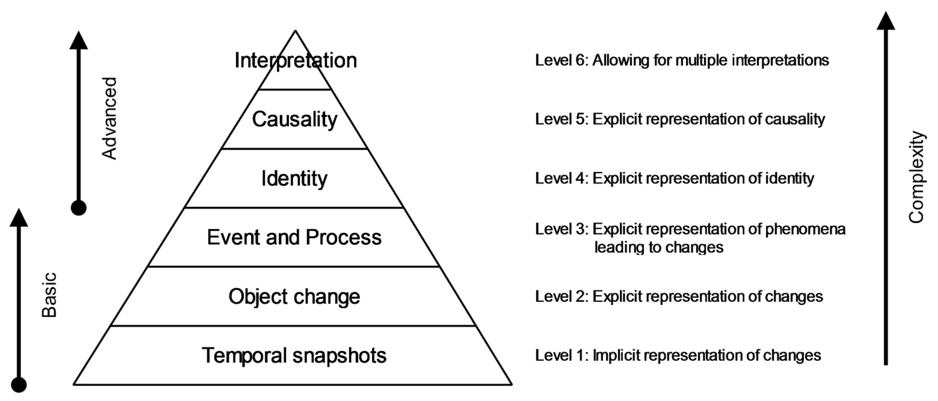
3. Levels of Functionality

3.1. A Pyramidal Structure of Functionality

This section gives the details of the six levels corresponding to the pyramidal framework. As previously mentioned, this framework is based on Worboys’ terminology [2] which, according to Peuquet [71], represents the three main stages by which the development of spatio-temporal modeling has evolved: the first stage with the snapshot model, the second with the object-based model, and the third with the event-oriented model. However, Worboys’ terminology dates to 2005, and the growing number of spatio-temporal models makes it difficult to classify existing models using this terminology. Consequently, we enrich the Worboys’ classification with new levels of functionality. In addition, each higher level expands the capacity to represent, analyze and process information from the previous level. Figure 1 illustrates the pyramidal framework, with its ordering of the different levels.
The six levels are described as follows:
  • Level 1—Temporal snapshots: The world is viewed as a succession of time-ordered snapshots of spatial object configurations. This modeling helps one to answer a basic question such as “Are there changes?”.
  • Level 2—Object change: “The focus shifts from the temporal sequences of objects, their attributes and relationships, to the changes that can happen to objects, attributes, and relationships” [2]. Now, one can answer the following question: “What are the changes?”.
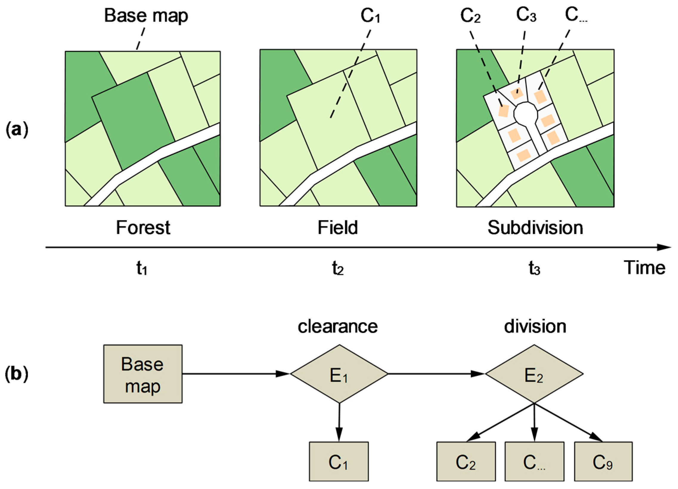
  • Level 3—Event and Process: Compared to level 2, level 3 gives an explicit representation of the phenomena by introducing the concepts of event and process. Spatio-temporal phenomena are treated as a collection of happenings. Events and processes are considered distinct entities.
  • Level 4—Identity: Identity is the certainty of being able to continue to refer to the object consistently despite its changes. The concepts related to this need are already known and well-identified. However, we believe that they are not fully exploited and that there is still potential for improvement. First, a fine-grained modeling of identity should explicitly distinguish the concept of identity from the one of identification. Secondly, managing the identity of geographic objects also raises several issues in terms of usages and points of view. Indeed, the identity of the same geographical object will not necessarily be the same depending upon the domain in which it is studied. Consequently, the object identity must also be defined according to the users.
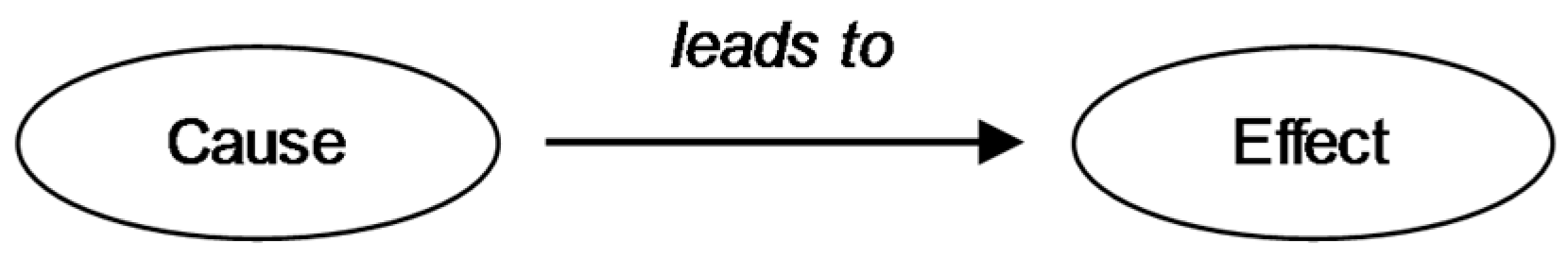
  • Level 5—Causality: Causal analysis is essential when studying geographical phenomena, because it serves to justify them, to give them meaning. It turns out to be a foundational element of logical reasoning. It is from this level of modeling that we can fully answer the question: “Why changes have occurred?”. Equipped with this, it becomes possible to document the origin of the modifications. Moreover, in the case of multiple interpretations, the representation of the cause may be the factor that justifies one choice of interpretation over another.
  • Level 6—Interpretation: the same event is not necessarily perceived in a similar way by different people and can consequently induce different meanings. Indeed, the way a human perceives a geographical object, or a fact, depends on his experience, his field of expertise (e.g., geographer, architect, urban planner), and the context of the study. In addition, relationships between events such as causal relations are often a matter of subjectivity and understanding. For example, two experts do not always approach identical data in the same way. Therefore, a spatio-temporal model managing interpretation should support dissimilar descriptions and interpretations of the same objects and events. It should therefore be able to handle multiple contextual viewpoints on the same real-world occurrences.
In the following sections, we provide more details. We also expand on the definitions and specifications related to each functionality level within the pyramidal framework. In addition, we highlight the key properties inherent to each level and describe the models that use each of them.

3.2. Level 1: Implicit Representation of Changes

This first category is characterized by implicit handling of spatio-temporal phenomena: neither these phenomena nor their changes are explicitly represented. Models in this category are those that assign a temporal reference (instant or interval) to layers, attributes, or spatial objects.
This first level mainly corresponds to temporal snapshot models. For instance, we can mention the sequential snapshots model [17,72], the simple time-stamping model [17,73] as well as the space-time composite model [17,74]. In the sequential snapshots model, temporal information is managed by a multitude of static geographical layers. Each geographic layer is an entire copy of the territory of analysis, representing the geographical objects at a specific time. Figure 2 illustrates how this model operates. We take as an example the evolution of a parcel that initially contains a forest (Figure 2a). The forest is cleared and then cultivated for several years. Then, the parcel is sold to a real estate developer, who then divides it into lots for sale. Each of the temporalities t1, t2, and t3 corresponds to a temporal snapshot of the entire study area (Figure 2b).
Overall, these models have pros and cons. For example, the sequential snapshots model is the simplest spatio-temporal data model. It can be directly implemented in existing GIS software [75,76,77,78]. Nevertheless, we can observe that these models do not keep the history of the operations performed on the geographical objects. This creates a number of drawbacks. Basically, this type of model does not provide a mechanism to preserve the filiation information since there is no link between the parent object and new objects. For example, in the case of the division of a geographical object, the simple time-stamping model does not store a direct link between the identifier of the initial object and the identifiers of the two new objects [79]. Yuan [80] also points out that these models struggle to represent dynamic information, such as transition, movement, and processes. In addition, they have difficulties dealing with the spatio-temporal relationships between spatio-temporal objects [78]. However, the straightforward implementation of these models makes them still usable. Thus, more recent models are still based on these early proposals. For example, Gómez et al. [81] propose a formal spatio-temporal data model based on snapshots and timestamping and use it in a spatial on-line analytical processing (SOLAP) environment. Other models combine the snapshot design with other concepts. This is the case, for instance, in the works of Vidal and Rodriguez [82], Gutiérrez et al. [83,84,85], and Worboys and Duckham [86]. They use the concept of event in combination with the one of snapshot. However, as these models use the event concept, we consider they belong to our third level of functionality.

3.3. Level 2: Explicit Representation of Changes

In this second category, changes are explicitly modeled. However, the spatio-temporal phenomena at the origin of these changes are still left out. These models focus on changes occurring in objects, their attributes, or their relationships. They include models such as the history graph model [36,37,87] and the life-motion-succession model [88]. We could also include other models such as identities through time [89] and identity-based change [43,90,91]. However, these last two models also rely on changes in the identity states of geographic objects, which are discussed in more detail in Section 3.5.
The principle of these models is to describe the history of a geographic object through a succession of states (static states) and transitions (states of change). Each transition is an entity that links the object versions with its successors or predecessors. The states, as well as the transitions, can be temporal snapshots or have a duration. Figure 3, taken from the history graph model, shows an example of the evolution of parcels that separate and merge. The states are symbolized by rectangles, while the transitions are represented by circles. Each state is necessarily linked to another state by a transition.
We notice that each model provides its own classification of transitions. For example, the history graph model proposes seven transitions, namely creation, alteration, destruction, reincarnation, split/deduction, merge/annexation, reallocation [87]. The identity-based change model, focusing on the notion of composite objects, introduces 29 transition operations [90,91]. Figure 4 represents the set of operations defined by Al-Taha and Barrera [89]. These transitions were subsequently extended by Hornsby and Egenhofer to develop the identity-based change model.
Figure 5 illustrates the previous example of parcel evolution (Figure 2a), as used in the temporal constructs model. This model allows for the explicit recording of the different changes.
Some models, such as the history graph model, allow for a duration to be added to the transitions. By doing this, it is possible to reproduce gradual changes. According to Pelekis et al. [7], this kind of model supports most types of spatio-temporal queries. Like temporal snapshot models, more recent models use the mechanism of explicit representation of changes, often coupled with other concepts. They are more suitable to describe events or processes. See, for instance, the work of Vidal and Rodriguez [82], Xue et al. [93], and Yu [94].

3.4. Level 3: Explicit Representation of the Phenomena Leading of Changes

According to Yuan, “Events are essential to understanding the world and communicating the understanding” [95]. The main idea of this third level is to explicitly model the events that have caused the changes (but not necessarily the changes themselves). As stated by Worboys [2], the event-type entity corresponds to the occurrents (events, process, actions) introduced in the SPAN ontology. In the literature, the term “event” is very often associated with the one of “process”. These two terms are used to qualify the dynamics of geographic objects. However, in GIScience, there is no consensus on the exact meaning of the words “event” and “process” [41,96,97,98,99]. This may be explained to some extent by the distinct interpretations they may convey in spatio-temporal modeling processes. Thus, these two concepts vary considerably from one author to another. As a result, several ways exist to approach the multiplicity of definitions. For example, Worboys [2] mentions an “astonishing variety of usage and definition”, pointing out that “one person’s process is another’s event, and vice versa”. Galton [100] argues that such discussions not only concern the terminology but they also significantly affect the conceptual foundations of how we represent and reason about the world. More information on these concepts can be found in Galton’s work [100,101,102,103,104].
In this paper, we consider that an event describes the course of a phenomenon (e.g., deforestation, urban sprawl, soil erosion). At the temporal aspect, an event can be instantaneous or durative. Moreover, the outcome of the event’s occurrence does not necessarily imply the transformation of an object (for example, an event such as a census population, which has a duration and frequency, does not transform the landscape or the buildings’ structure.
In this third level, the event is the action that causes the changes. It provides meaning and significance to the changes. It encompasses the models belonging to the category of event/process-oriented models. In order to harmonize the terminology, we refer to event/process-oriented models. This category includes all spatio-temporal models based on events and/or processes. However, for the sake of clarification, the description of the models below uses the original terminology formulated by the authors.
This kind of spatio-temporal model assumes that changes affecting spatio-temporal entities are produced by phenomena called events or processes. As a result, these phenomena are explicitly modeled by conceptual entities in their own right. In summary, an event/process-oriented model explicitly records all the changes made to analyzed data in a transaction log. By browsing the history of the transactions in the log, the different past states of the map can be obtained. The transaction log acts as a temporal database. One of the benefits of placing the event (or process) at the same level as the geographic objects is that the resulting data models are able to apply the well-known mechanisms of object-based queries to events (or processes). Under these conditions, they can perform queries involving geographic objects and events like object-event and event-event relationships [105,106]. Moreover, if a distinction is made between events and processes, then it is possible to include complimentary relationships such as event-process and process-process.
To illustrate how these models operate we introduce temporal geographic information systems (TEMPEST) [33] and geospatial event model (GEM) [105]. TEMPEST is the first model to use the event/process concept. GEM is an interesting case of a model belonging simultaneously to two levels of functionality. Of course, we could have described other models, including the event oriented spatio-temporal data model (ESTDM) [34] or the spatio-temporal processes framework [107,108,109]. The event-oriented approach [35] is also interesting. Indeed, this model has the particularity of integrating both version and event concepts to describe the successive states of spatial objects. Other more recent models such as the event-driven spatio-temporal data model [110] and its derived model [111] could have been mentioned as well.
TEMPEST [33] is a ST-GIS relying on the triad framework [31] approach. The model works as following: starting with an initial state (the base map), events are recorded in increasing temporal order, with each event associated with a list of changes that occurred since the last update of the event list (Figure 6). This solution is similar to the one proposed by Yeh and Cambray [112] in the highly variable spatio-temporal data model. As stated in the triad framework, an event may represent a sudden change or can be triggered when a set of small changes is considered to be significant enough to create a new record.
Figure 7 illustrates how TEMPEST works with the example of the evolution of a parcel. The events (clearance and division) are successively applied to the base map. We can notice that, unlike level 2, the types of transformations (e.g., reallocation, separation) are not necessarily specified.
Worboys and Hornsby [105] describe GEM as an object-based model extended by the concept of the event. This model is based on Worboys’ previous work on events [2] as well as Grenon and Smith’s work on continuants and occurrents [44]. Galton provides a short definition of continuant and occurrent: “A continuant exists wholly at each moment of its existence. It endures through time, possibly gaining or losing parts, and changing with respect to some of its properties. It may have spatial parts but not temporal parts. An occurrent unfolds over time (itperdures), and has temporal (and possibly also spatial) parts.” [104]. In this model, the continuants are the objects (e.g., houses, roads, cities...) and the occurrents are the events (e.g., a house repair job, road construction project, urban expansion...). GEM is based on three elementary entities: objects, events, and settings (Figure 8). The distinguishing characteristic of a geospatial entity is its setting, whether an object or an event. A setting can be purely spatial (e.g., point, line, or surface), purely temporal (e.g., instant, interval, or period), or a spatio-temporal (e.g., trajectory, history, or geospatial lifeline). However, an object or an event cannot be contained in more than one setting at a time. In addition, the object is considered static, i.e., timeless. Thus, the settings in which an object can be situated are purely spatial.
At the relationship level, participation and involvement are used to indicate that objects participate in events and events involve objects. Worboys and Hornsby also specify event-object relationships (creation, sustaining in being, reinforcement/degradation, destruction, splitting/merger) and event-event relationships (initiation, perpetuation/facilitation, hindrance/blocking, termination). One of the characteristics of GEM is to be able to describe combination relationships as well as temporal relationships between elements. Another specificity is its capacity to describe relationships between events through event-event relationships. Since it allows for event-object relationships to be stored, and since it explicitly represents events, GEM belongs to both functionality levels 2 and 3.

Analysis

The majority of event/process-oriented models offer a resolutely visual and chronological approach, either by allowing the lifeline (evolution) of a given geographical object or by reconstructing the course of geographical changes that have taken place in a given area of study. The events/processes are then considered as phenomena producing changes in geographical objects. Some models such as TEMPEST [33] or the event-oriented approach [35] enable a distinction to be made between observed changes (e.g., a change in land use following a forest fire or the construction of a housing estate in agricultural land) and events/processes on a larger scale (e.g., deforestation, peri-urbanization). Since documenting the evolution of geographical objects by describing the changes that have taken place is already a way of studying and interpreting these phenomena, we can also understand why some models do not distinguish between events and processes.
In this level, we can identify four categories of models:
  • Models that do not integrate the notion of the object as an entity that persists over time (e.g., cities, packages, cars). Furthermore, they do not provide explicit relationships between events since they only represent them as a simple sequence of temporal features that follow one another. In this category, we find models such as TEMPEST [33] or ESTDM [34].
  • In the second category, object-event relationships are represented as in the work of Vidal and Rodriguez [82], Worboys and Duckham [86], Lohfink et al. [114,115], or those of Hamdani et al. [116].
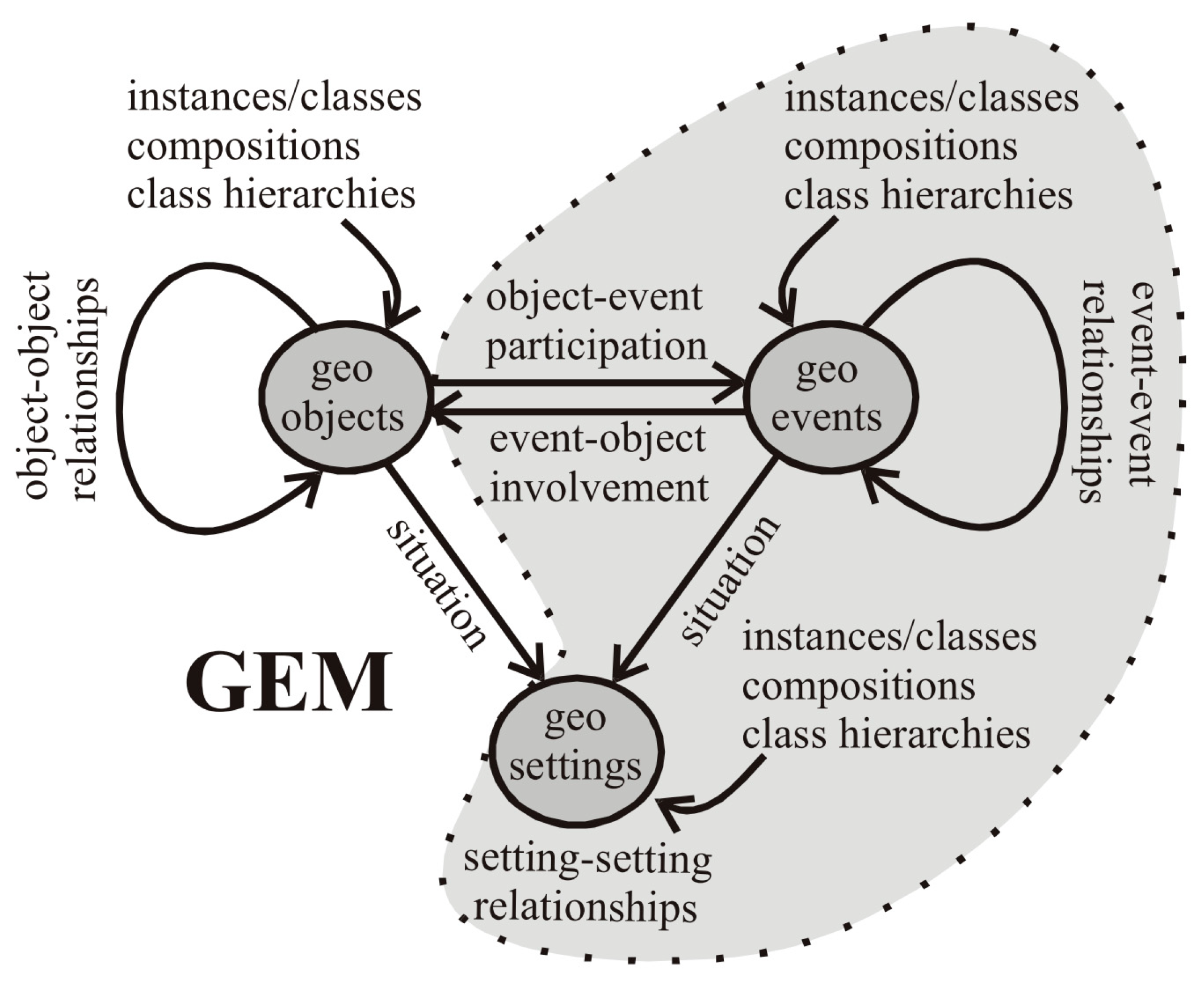
  • Models that are explicitly adding object-event and event-event relationships, but are not differentiating between events and processes. Therefore, they do not express links between the two (e.g., process-event). GEM, presented earlier, is a good illustration of this.
  • Models that make the difference between event and process. In these models, the relationship between process and event is expressed through an aggregation relationship. For example, events can be seen as an assembly of processes, such as in the event-oriented approach [35] and the spatio-temporal processes framework [107] where events are defined as a set of processes that transform entities. In [117], events consist of multiple processes.
In other cases, events and processes are of different kinds and allow more complex representations, for example, the spatio-temporal knowledge discovery process [118]. Venkateswara Rao et al. [118] use the following example to illustrate their approach: “For example, an event rainfall over a period of time may have caused the spatial object like a land parcel to change its shape and also its surface features like crop or vegetation. The event rainfall may have caused process flood at a particular location for some time”. In this model, the event records the causes of the changes to the spatial object and the process deals with the effect of changes to the object. We note that Galton [102] suggests a similar approach, but since it is more specifically dedicated to the representation of the cause, we will detail it in Section 3.6.4.
The classification of the various models we have just outlined relies, firstly, on the distinction between different concepts representing a geographical phenomenon, i.e., between object, event, and process, and, secondly, on the qualification of the nature of the relations between them. Other models use the concept of the event to optimize the computing performance of queries. For instance, Gutiérrez et al. [83,84,85] provide a spatio-temporal access method that combines snapshots and events approaches for modeling spatio-temporal information. This method increases performance on queries and storage space used by indexing. In the same spirit, the hybrid spatio-temporal data model and structure (HST-DMS) [119] is a variant of ESTDM [34] improving data storage and searching in large databases. We also find models based on spatial relationship changes between spatial objects. Some research focuses more on the topological aspect of changes such as [120] who provides a classification and analysis of events associated with changes in topological structures of spatial areal objects. Jiang and Worboys [120] employ a tree structure to represent topological relationships between regions and holes in areal objects. In another approach, Chee et al. [121] use state-and-transition models combined with dynamic Bayesian networks to represent spatial processes. The feasibility of their model has been demonstrated through a few ecological case studies (e.g., eucalypt woodland restoration and invasive willows).

3.5. Level 4: Explicit Representation of Identity

In the common sense, identity is defined as “the character of what is unique or constitutes a single reality, in various manifestations, forms or designations” [122]. In level 4, this concept is used to refer to objects in a consistent way despite changes that apply to them. It is a constant and timeless naming of the geographical object, which survives most of the changes that the object undergoes.
In order to better understand the identity concept, we begin by addressing some fundamental notions. Then, we describe how this concept is currently used in geographic sciences. We conclude with a discussion showing the reasons why this concept is currently not fully exploited, and then highlighting areas for possible improvement related to its utilization.

3.5.1. Fundamentals of Identity: An Individual’s Identity and Preservation of Identity through Time

In The Symposium, Plato formulates the identity of the individual in this way: a person remains the same from birth to death as he or she constantly changes [123]. This concept can be extended to animals as well as to physical objects, for example, a caterpillar turns into a butterfly while preserving its identity. Similarly, Leonardo da Vinci’s Mona Lisa painted in the 16th century is identical to the one on display in the Louvre today. This raises the question of preserving identity through time. Indeed, the passage of time necessarily implies changes. For example, Heraclitus says that all things pass, and nothing stays and maintains that one could not bathe twice in the same river, because new waters are constantly flowing [124].

3.5.2. Identity of Objects and Computer Representation

Regarding computer systems, the concept of identity appears quite early on. We can cite, for example, the work of Codd [125] who, as early as 1970, introduced the notion of identifier keys to represent the identity of an object. Khoshafian and Copeland [126] describe the different solutions being considered for managing identity in relational databases and programming languages. Khoshafian and Copeland indicate that most programming and database languages mix up the concepts of addressing and identity, as they only use variables to distinguish temporary objects. In addition, most database languages use identification keys to differentiate between persistent objects, thus confusing the notions of value (identifier) and identity. Khoshafian and Copeland deduce that these two approaches are not correct, as they alter identity. Although Khoshafian and Copeland’s article dates back to 1986, the whole argument is still relevant nowadays. This point is important since it has a significant impact on the way in which the spatio-temporal models currently manage the identity.

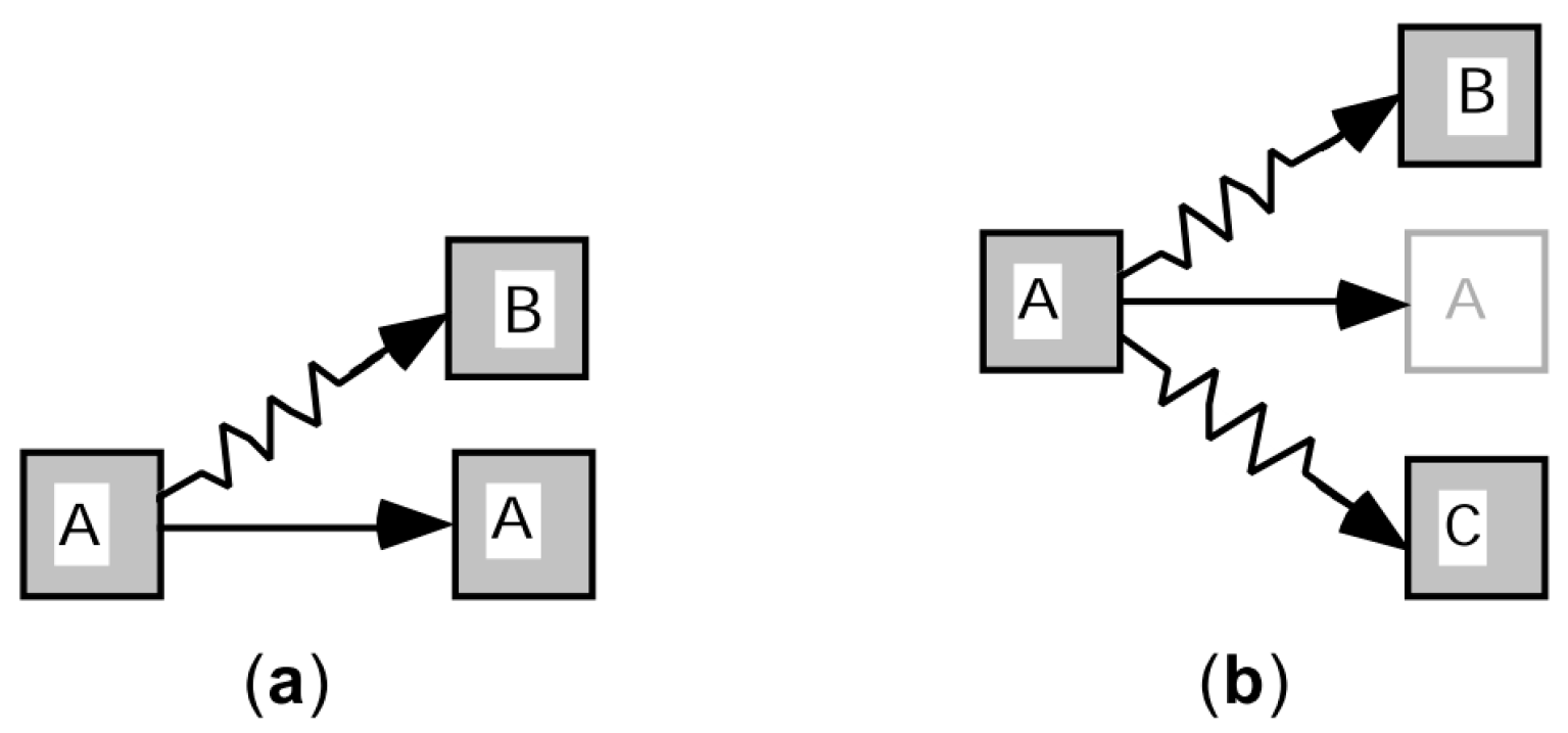
3.5.3. Filiation Relation

The filiation relation indicates a dependency on identity. It defines the succession link that exists between different representations of the same object at different moments of time [127]. This relationship helps to maintain the identity of an evolving object and can be used to identify the child objects resulting from evolution. Two main types of filiation relationships can be distinguished: continuation and derivation [43,127,128,129]. Continuation preserves the identity, which means that an object continues to exist despite the changes (e.g., a person’s identity persists throughout life). This is the case of preserving identity through time as formulated by Plato (Section 3.5.1). In the derivation, a new and distinct object is created from an earlier object (e.g., a new cadastral parcel is the result of the division of a previous parcel, see Figure 7. In addition, unlike continuation relations, derivation relations may involve several objects at the same time.

3.5.4. Identity in GIScience

Identity is a fundamental concept when it comes to following the evolution of geographical objects in space and time [8,90]. It is also used to represent unity, temporal continuity, and filiation. The definition of identity in GIScience and its use have been greatly influenced by work on relational databases as well as by work in object-oriented programming. Some of this work is found in GIS software such as ArcGIS and QGIS or in spatial database management systems such as Oracle Database and PostgreSQL. We can remark that, in these systems, the definition of identity mixes up the concepts of addressing and identity.
Here, we are more interested in works in GIScience that deal with the identity aspect at a more conceptual level. For example, the early research on identity started in the mid-1990s [89,90,130,131] and mainly uses identity as a tool to track changes in objects. Subsequently, further work took place in the late 1990s [43,91,92,109,132], focusing, among other things, on the notions of existence and non-existence and the study of similarities and differences between objects in scenarios of change. In the 2000s and 2010s [127,128,129,133,134,135,136,137], the work expanded to include other prerogatives, such as the integration of fuzzy set theory, the implication of scale changes, and the study of moving objects. Concerning the spatio-temporal models, mainly two categories of models integrate the concept of identity within their modeling. The first concerns the models based on the object-oriented paradigm and the second those based on identity changes. Models based on the object-oriented paradigm are based on the use of objects and classes as central concepts. They also rely on abstraction mechanisms such as classification, generalization, polymorphism, association, and aggregation [138,139,140]. The object-oriented approach is particularly well suited to modeling complex situations such as the variance of data over time [25]. To do so, it is mainly based on the concept of object identity previously mentioned in computer science. As mentioned in Section 2.1, space-time models began to include object-oriented concepts since the late 1980s. We can mention, for instance, the works of Price [26] or Worboys [141,142] in that field. Alongside the well-known models, we can also mention the Raper and Livingstone [143] model dedicated to environmental data modeling, as well as the Hamre [144,145] model or the Wachowicz and Healey [30,146] model. Worboys and Hornsby [105] have also proposed other models, including GEM, which we have described earlier in Section 3.4.
In parallel to this work, other studies focus more specifically on the use of the concept of identity within spatio-temporal models, i.e., models based on identity changes. The first model based on this principle is Al-Taha and Barrera’s identities through time [89], which we introduced in Section 3.4. Subsequently, several models followed, the most cited in the literature is certainly the identity-based change of Hornsby and Egenhofer [43,90,91]. The particularity of this model lies in its ability to describe the changes of states linked to an identity of the geographical object based on the concepts of existence and non-existence. Meanwhile, the concept of identity has been a key consideration in the design of other models such as those of Sriti et al. [135] or Stell et al. [128]. More recently, Hallot and Billen [137,147] propose the spatio-temporal states of identity model. This model is defined as the combination of the state of existence and presence of an object in space at a given time. It uses an extended vision of the identity of the object to apprehend the combination of its existence and presence.
The majority of models based on identity changes use identity-based change [43,90,91] as a reference. Thus, this model is quite representative of this type of modeling. The identity-based change conceptual model is based on the identity of objects and describes changes in the identity states of geographic objects. To do so, it relies on two kinds of primitives: identity states of objects and transitions. Each object is assigned a unique and persistent identifier as well as a variable state according to the changes it undergoes. The life of an object can be determined through the different states associated with it over time. An object can take one of the three following states (Figure 9): existing object, non-existing object without history, non-existing object with history. Non-existence with history refers to an object having existed previously and non-existing object without history corresponds to an object that has never existed.
Like identities through time [89], changes are modeled by a transition describing the progression from one state of identity to another. Two families of operations can be distinguished: identity changes affecting a single object (e.g., create, destruct, continue existence, continue non-existence, recall, reincarnate, destroy, eliminate, forget, etc.) (Figure 10) and those involving multiple objects (e.g., aggregate, compound, unite, amalgamate, combine, splinter, divide, secede, dissolve, etc.) (Figure 11).
We can notice that the identity-based change has been extended, by adding extra types of spatial change [148] and by adding more primitives and operations to better describe the changes and interactions of individual objects and composite structures [149].

3.5.5. Analysis and Proposals

We will now identify the shortcomings of models based on identity changes and those based on the object-oriented paradigm. Then we will present our recommendations. In the case of models based on identity changes, the evolution of objects is achieved by changing their identity once a modification appears. To do this, these models follow one or more criteria, usually the spatial component of the geographic object. However, this raises a series of problems.
First, using a single attribute of the geographic object as a marker of identity is insufficient for realistic modeling. For example, by identifying an object by its name, it ceases to exist as soon as it changes its name, whereas it actually is the same object with the same characteristics but with a different name. An example is the city of Saint Petersburg which changed its name to Petrograd, then was renamed to Leningrad, to finally regain its original name. This is a problem related to the context of the study and the choice of the definition of identity.
The second problem is to impose a pre-established list of transformations. Indeed, as pointed out by Claramunt et al. [108], it is not possible to establish an exhaustive list of all spatio-temporal processes because there are no universal criteria for classifying them. Such models are unable to describe a situation that is not totally covered by their original classification. In the model described above, namely, identity-based change, the identity is defined by the spatial component of the geographical object and the model provides a list of changes that can occur on the object. Let us take a real case. In the United Kingdom, the Ordnance Survey (the government agency in charge of large-scale cartographic data), considers that, when the geometry of a geographical object is modified due to a change in its boundaries, it remains the same object and its identity is preserved. However, in the case where the resulting object has a footprint less than half the size of the original object or more than twice the size of the original object (The example is adapted from [150].), a new identity has to be assigned to it. The identity-based change model is unable to handle this case. Indeed, the rule for assigning the new identifier in the Ordnance Survey differs from the transformations provided by the identity-based change. So, this model, although generic, is not capable of responding to this case. We like to point out that models such as identities through time or identity-based change are not specific models for the representation of object identity: they use the concept of identity to manage the evolution of objects. Their aim is not to qualify identity, the latter is only a way to follow the transformations. In fact, some authors, such as Worboys [2], Haddad [96], or Gharbi [98], do not put these models in the category of models managing identity, but as models based on the explicit representation of changes, i.e., models belonging to the level 2.
For models based on the object-oriented paradigm, the concept of identity is used to distinguish geographic objects from each other. When an object is created, it is assigned a unique and invariant identifier, allowing it to be referenced independently of other objects: each object has its own identity. In addition, the identifier remains the same when changes are considered small enough (i.e., not requiring the creation of another object). This solution is relatively easy to implement, which is why it is commonly used in databases. However, this solution calls for an explicit specification of the criteria and conditions that determine when a change is big enough for a new identity to be assigned to the new object state. There is an amalgam between the concept of identity and that of identification. In this case, identity management boils down to a single identifier, which is insufficient.
These observations show that current spatio-temporal models only partially fulfill our level 4 of functionality (Section 3.1). This leads us to formulate two proposals.
The first one concerns the separation between the concepts of identity and identification. We discussed this point in Section 3.5.2. Current spatio-temporal models rely essentially on the identity vision provided by object-oriented modeling languages such as UML to manage identity. However, this approach does not correspond to the notion of identity that we have intuitively, i.e., as presented by Plato (Section 3.5.1). According to Plato, the entities (Plato’s entities correspond here to geographical objects.) change rather than being destroyed or created. We perceive both modification and continuity in the identity of entities. This brings us to the following proposal:
Proposal 1.
The concepts of identity and identification must be expressly separated.
Our second observation concerns the context and the point of view (respectively Section 3.7.2 and Section 3.7.3). To illustrate our idea, let us consider the evolution of the name of the city of Saint Petersburg. In a toponymy study, the name of the city is the essential element. In an urbanization study, it would be the surface area of the buildings which are the data to be taken into consideration. In this second case, the name of the city has limited importance. Thus, the definition of identity is highly dependent upon the context of the study. To clarify our arguments, let us consider the example of monitoring the history of geographical objects in the United Kingdom and compare it with the methods used in the Netherlands. In the Netherlands, the history management system is based on the NEN 3610 standard [151], which is like the one used in the United Kingdom. The difference lies in the rules for handling identities. In the Netherlands, if the resulting object has a surface area less than two-thirds of the original object or greater than four-thirds of the original object, then a new identity must be assigned (The example is adapted from [151].). To illustrate our point, consider the case of a building extension. The surface area of the building increases from 100 m2 to 140 m2, an increase of 40% (Figure 12a). In the case of the United Kingdom, the identity is maintained (Figure 12b), while it changes for the Netherlands (Figure 12c).
In many cases, the definition of identity depends on the user’s point of view. The latter could, for example, take the form of a subject-specific description of the rules related to surface changes. These considerations lead us to conclude:
Proposal 2.
The concept of identity only makes sense in a context and depends on the users’ point of view.
Thus, identity management is much more complex than it first appears. We believe that managing the identity of the geographic object should not simply be relegated to an implementation detail in the IT system. Indeed, just because a solution already exists, it does not mean that it is necessarily optimal or adapted to the needs. We think that identity management must be an integral part of the spatio-temporal model and be explicitly expressed by it. The attribution of identity must be variable and made according to the field of application and the user’s point of view. For these reasons, the spatio-temporal model must be flexible when it comes to defining the rule by which identity is assigned. Moreover, the definition of identity must cover all the constituents of the geographical object, namely, the spatial, temporal, and thematic aspects. We believe that the spatio-temporal models of level 4 must equivalently consider these three aspects without favoring one more than the other.

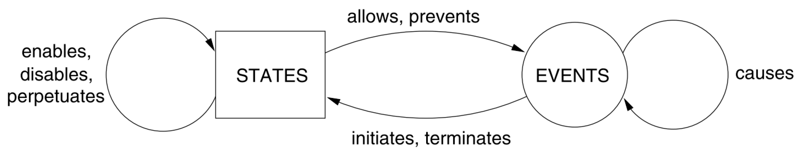
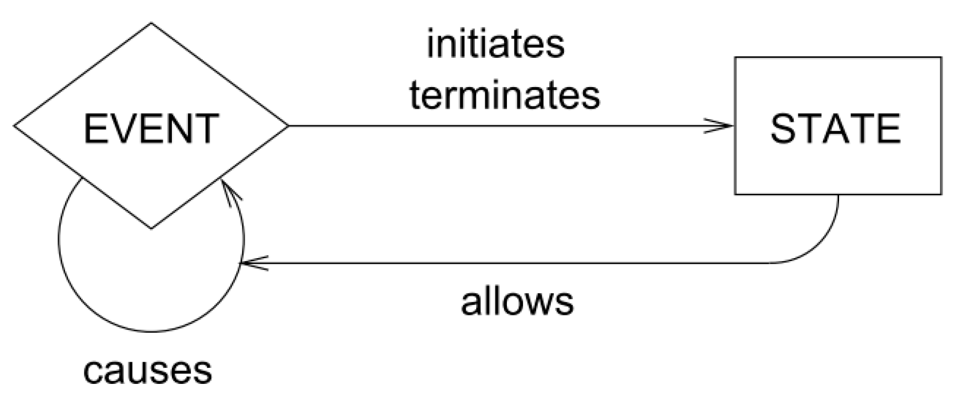
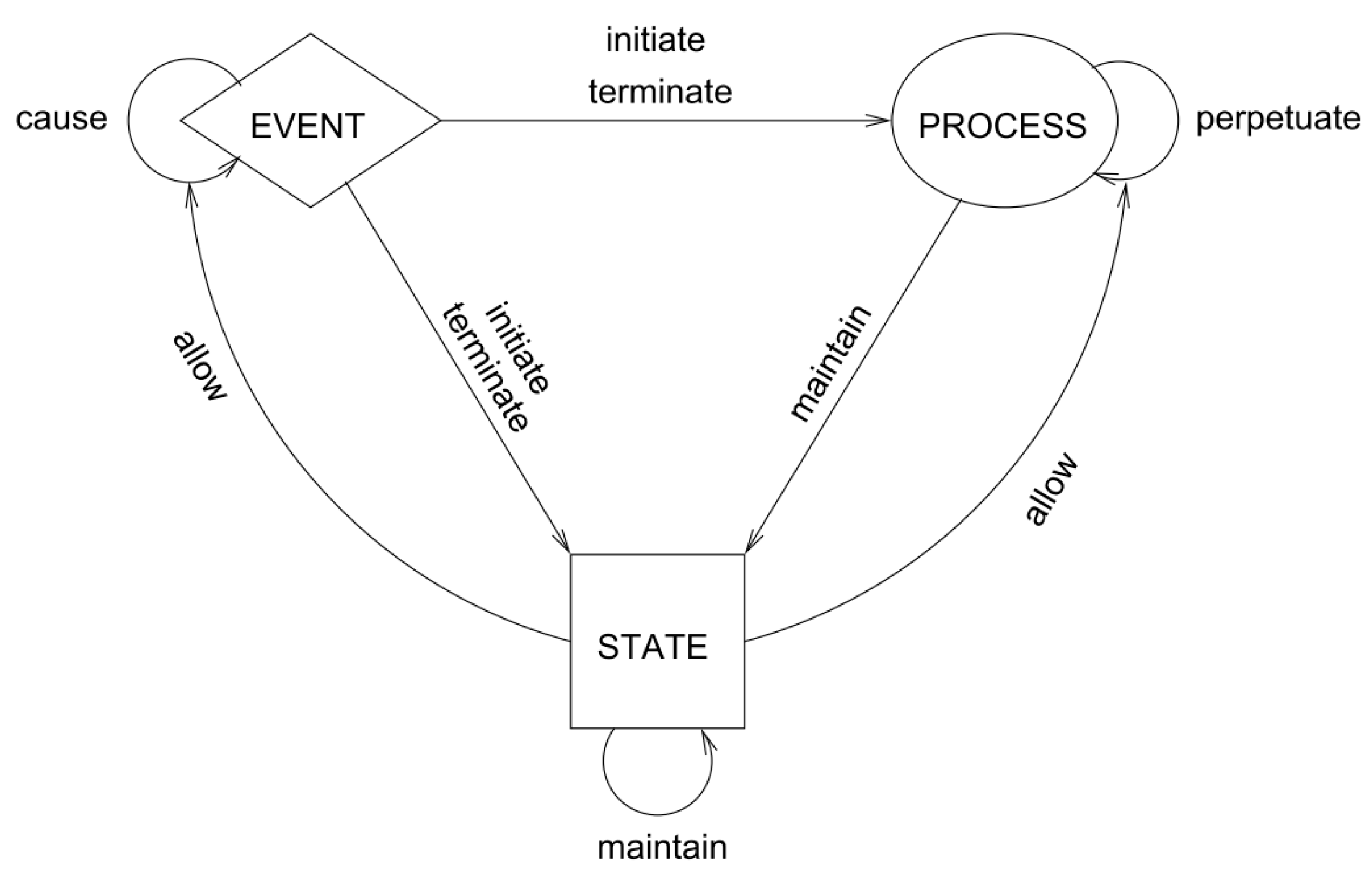
3.6. Level 5: Explicit Representation of Causality

Level 3 models can capture changes together with the events and processes that led to these changes. However, a comprehensive study in a phenomenon does not only consist in tracking and storing the evolution of geographical objects. Level 3 models cannot trace the factors that caused the changes. To do this, it is necessary to consider and integrate the causal mechanisms that are at the origin of these results.
In the field of GIScience, El-Geresy et al. [6] argue that the development of conceptual spatio-temporal models requires a fundamental study of causal relations. Claramunt and Thériault [35] indicate that a temporal GIS must explicitly preserve the links between events and their consequences in order to reproduce the dynamics of spatio-temporal processes. Researchers are thus able to study complex relationships, draw conclusions, and verify causal links that associate objects with processes of influence and transformation. A representation of causality is a valuable aid to a better understanding of the various spatio-temporal phenomena. Causal reasoning belongs to one of our most essential cognitive faculties. Indeed, the knowledge, understanding, and interpretation of causes allow us to predict future events or to explain the occurrence of present events. Thus, the cause-and-effect relationship is the basis of our predictions and plays an important role in decision-making. As Sowa [152] points out, three academic disciplines are mainly interested in questions about causality: philosophy, theoretical physics, and artificial intelligence. Therefore, the notion of cause has long been addressed and discussed in philosophy [153] but also by sciences such as physics [154]. The line between philosophy and science is sometimes thin, one relying on the other. For example, the philosophical notion of cause provides a substantial contribution in fields such as ontological engineering [155] and artificial intelligence, by proposing qualitative approaches to help understand and interpret physical phenomena [156,157,158].
In the following, we give a definition of cause and present the essential notions of causal reasoning. Then, we examine the issue of managing causality and the main associated concepts in the field of GIScience. Finally, we conclude with an analysis related to the integration of this concept in spatio-temporal models.

3.6.1. Causality in Philosophy and Science

Along with the terms event and process, the concept of causality needs to be clarified. However, the literature on causality is far too large and vast even for a superficial study. Therefore, we limit our discussion of the term cause to the fields of philosophy and science. Moreover, this section does not aim at presenting an exhaustive overview of the existing work, but rather to provide reading keys necessary to understand the models presented below.
Causality is a philosophical dilemma that examines the existence of links between cause and effect [159]. According to van Laer, the “cause” can be defined as “a reality that exerts an influence on the becoming, the being, or way of being of another reality” [160]. For example, an object becomes a cause only when it is active. There is no time delay between a cause and its effect because a cause is produced at the same time as the effect. There is, however, a priority attributable to the cause, but it is a priority of nature and not a priority of time. Under these conditions, it is not possible to infer the “how” from the causal influence, because the causal influence is not observable [160]. This is the first way of conceiving causality in philosophy.
Some authors have a different view. In the context of geographic data, it is this second perspective that interests us. According to Spinoza, everything can be explained, at least in principle. Everything has its cause, through which it can be explained. In this perspective, any finite action is part of an infinite chain of causes [161]. Modern philosophical discussions tend to treat causality primarily as a “relation between events” [162]. With this approach, examples of causal statements are in a basketball game, the movement of the hand causes the ball to move and the entry of the ball into the basket results in scoring a goal. However, “if a particular event is the effect of a combination of causes, it may be false that any of these causes necessitated the effect” [162]. For example, Smith’s early morning swim caused his heart attack but only in conjunction with his hearty breakfast. Thus, a cause is an element in a set of conditions that jointly are sufficient for its effect. This is close to Mackie’s idea that causes need at minimum of INUS (“Insufficient but Necessary parts of a condition which is itself Unnecessary but Sufficient for the result” [163].) conditions to achieve their effects. We can notice that the concepts underlying the different causality models proposed by Galton in GIScience (Section 3.6.4) are similar to those described by Spinoza and Mackie.
Readers interested in further exploring the philosophical subject can refer to the papers such as the Aristotelian theory of causality [164], which deals with motivation and willingness to act. Leibniz’s principle of sufficient reason is also interesting because it states that everything must have a reason or a cause [165,166]. Other works are also relevant, such as [167,168].
In physics, the terms “cause” and “effect” are usually referring to observable facts and situations (e.g., sensor data). The “cause” is the element observed first, the antecedent. The “effect” is the element observed second, the consequence. The relation between two situations or two facts that follow one another is called the “causal relationship”. In this case, the causal relationship indicates only a correlation between observable data. Unlike philosophy, the causal relationship is not an active principle here; it is only an indication of a situation capable of producing a change of state [154]. By adding the notion of determinism (in the physical and not the philosophical sense of the term), the way causes act, as well as the exact and complete knowledge of a certain initial state, we obtain the “principle of causality” (also called “law of causality”), as it is defined in physics (classical mechanics) [154,160]. This principle is expressed as follows: “If an initial state of a given system is known exactly and completely [...], as well as the way of acting of the causes in question, one can predict its future state” [160].

3.6.2. Cause in GIScience

Compared to the above-mentioned disciplines, systematic treatments of causality in the geographic sciences remain quite limited. We can, however, cite the work of Allen et al. [169], which outlines the major theories of causality in the fields of geomatics, computer science, and philosophy. Similarly, we can retain [6,170], or [96] which are also referring to the notion of causality. Galton et al. also carry out interesting work in geomatics such as [171,172,173] or in computer science [102,104]. More recently, Huang et al. [174] propose a framework to assist in the interpretation of geographic scenarios including the representation of the cause.
Modeling the cause offers several benefits. The first is to reconstruct the history of the evolution of geographic objects by analyzing the causes and consequences. For Allen [169], causal modeling could be achieved through the concept of the event. To this, he says that causes and events must be entities possessing both spatiality and temporality. Claramunt and Thériault [35,107] indicate that a complete model must explicitly preserve the links between events and their consequences in order to reproduce the dynamics of spatio-temporal processes. Thus, it becomes possible to study complex relationships, draw conclusions, and verify causal links associating entities through influence and transformation processes. According to Courgeau [175], the results of a study depend on the underlying assumptions made in each analysis and on the identification of the factors explaining the phenomena. Thus, by modeling and analyzing the causes and reasons that led experts such as historians, economists, or urban planners to make certain choices, we can retrospectively validate or invalidate the results. Moreover, a hierarchical approach of causal modeling increases the expressiveness of the model [176]. We are convinced, like El-Geresy et al. [6], that it is valuable to include notions of causality in spatio-temporal models.

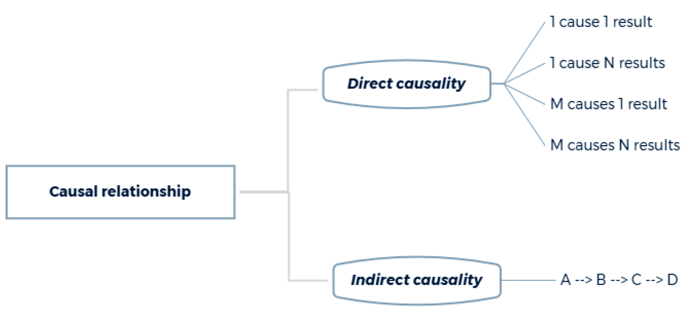
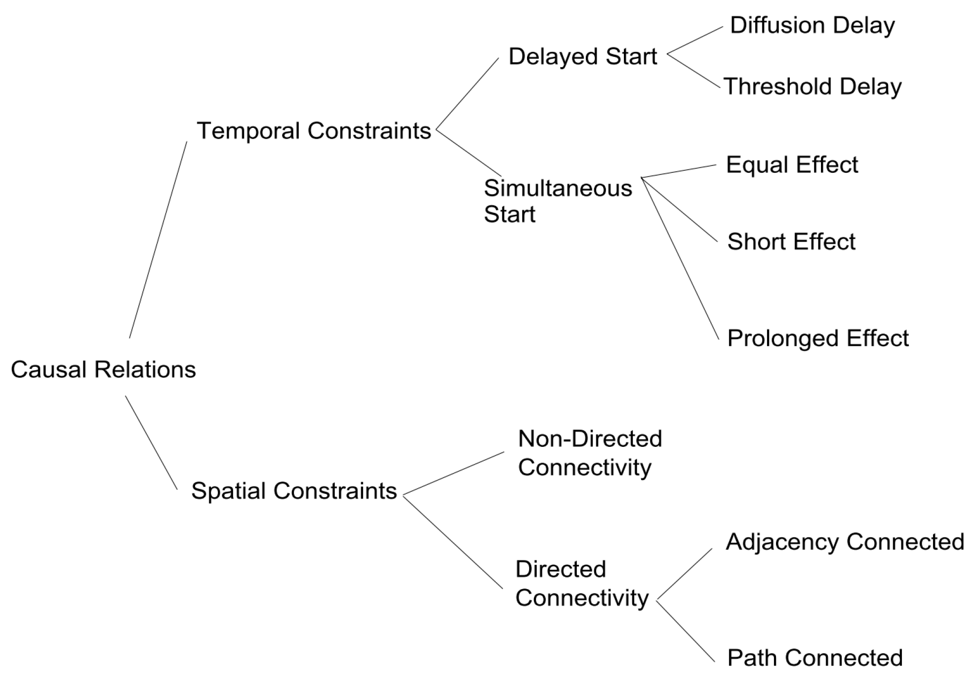
3.6.3. Characteristics of the Cause

Based on the above discussions, we select a set of concepts that, from our point of view, are the most valuable to further enrich the geographic information modeling process. These concepts together represent the essential conceptual framework that a spatio-temporal model should introduce in its design in order to manage causality.
Causal structure and relation to events
The causal structure is illustrated in Figure 13. It provides information on the causal link and the direction of the relationship.
The cause is what produces or provokes an effect. The cause is the origin, and the effect is what comes after. The effect is described as the consequence of the cause and has the particularity of being linked, directly or indirectly, to the cause. Moreover, the concept of causality is closely related to that of the event. Indeed, according to Quinton, events are the most natural way to represent causal relations [178]. Besides, cause and effect can be seen as specific types of events [179,180].
Chain of causal relations, plurality of causes, and significant causes
A chain of causal relations is a successive set of causes and effects that lead to an effect [154]. It can be described as a chain of events that maintain the causal flow and coherence of the story. In order to illustrate how the chain of causal relations works, we introduce a concrete example, inspired by [181]., involving the phenomenon of deforestation. Deforestation has multiple causes: new spaces freed up for agriculture, overexploitation of wood resources (construction, paper, etc.), mining, construction of industrial infrastructures, etc. The consequences of deforestation are also diverse: intensification of erosion, deterioration of soil structure, displacement of organic matter, chemical pollution of water, etc. To better understand the concept of chain causal relations, we simplify our example with the following scenario (Figure 14a). The initial state corresponds to a forest area. Agricultural needs lead to the clearing of some of the vegetation, which in turn induces soil erosion. This resulting chain of causal relations is illustrated in Figure 14b.
To this notion of a chain of causal relations, one also adds the plurality of causes. This term indicates that several causes are necessary to produce a particular effect [167]. Indeed, in the case of our example, deforestation alone does not explain soil movement. Soil movement is a phenomenon made possible mainly by water erosion and accentuated by tillage, which increases the soil susceptibility to erosion (Figure 15).
Moreover, among the multiple causes that generate the effect, some have more impact than others. According to Bohm “we may define the “significant causes” of a given effect as those conditions or events which, in the context of interest, have an appreciable influence on the effects in question” [154]. Identifying significant causes consists of finding the essential features of the effect. In our example, deforestation has several causes, but the main ones are agricultural needs such as field crops and livestock farming. Multiple causes leading to an effect may be difficult to identify. To do this, several modeling solutions are possible, a classification of direct and indirect causes is one of the solutions, which is presented in the next section.
Direct and indirect causalities
Huan et al. [174] mention that causalities in a geographic scenario can be direct or indirect (Figure 16). “Direct causalities have deterministic associations with driving forces that lead to predictable outcomes” [174]. For example, deforestation leads to soil movement. This is usually the closest cause to the effect. It provides the most information and justification. “An indirect causality connects seemingly unrelated elements, which suggests potential causes to an issue” [174]. In our example, deforestation leads to the displacement of soil particles that end up in rivers and then in the river mouth. This results in more turbid water, which reduces the light penetration into the water and affects some species. For instance, in a tropical region, this decrease in light perturbs the development of coral reefs. Finally, a relatively long causal chain must be traced back to identify the source of the coral problems.
Temporal and spatial constraints
The cause, like any phenomenon, has both temporal and spatial characteristics. The main temporal constraint is that of temporal antecedence: the cause must be prior to, or at least simultaneous with, the effect [182]. Indeed, as defined in physics (Section 3.6.1), an effect cannot begin before its cause. Based on Allen’s time interval algebra [183], El-Geresy et al. [6] distinguish two main types of causal temporal relationships: the immediate effect (the cause and effect start together) and the delayed effect (the effect may start after its cause). Several reasons may be attributed to why the effect may start after its cause. For example, the change may not be able to produce its effect before reaching a certain level over a certain period of time (threshold delay), e.g., flooding will not occur until the river water rises above a certain level. The delay is due to the time it takes for the cause to reach its effect. Another reason for time delay is that cause and effect are not spatially co-located (diffusion delay). Pesticides and fertilizers spilled in a field can take a long time to pass through the aquifer and reach the water table, which is several tens of meters underground. The literature provides other temporal relationships, such as the temporary effect (which disappears before or after the end of its cause), the independent effect (the existence of the effect does not depend on its cause), the dependent effect (the cause maintains the effect) or the permanent effect (the effect persists after the cause) [40,96,171].
A spatial constraint can also be defined between the causal object and the affected one [182]. This constraint specifies that there must be spatial proximity between effect and cause [6,184]. The objective of this constraint is to reason about the causes of changes in spatial regions. Bhatt et al. [170,185] use the example of a deforestation phenomenon whose effect results in the shrinking of part of the forest area. In the same way, Mau et al. [186] provide a framework to characterize the impacts of events on vegetation changes. The model identifies causal relations in order to link events like forest burning, clearing, or flooding to their effects. The value of this model lies in its ability to help decision-making for planning and management in nature reserves or national parks. Figure 17 represents the classification of temporal and spatial causes proposed by El-Geresy et al. [6]. This classification has the advantage of being designed for spatio-temporal data.
Agency
In the case of causality, an agent is a resource that actively acts on the event with the implication of a causal relation. For instance, considering the occurrence of a flooding phenomenon, the river could be seen as the agent responsible for the rise of the water and thus for the resulting flooding. In terms of agency, the concept of the thinking being acting) can be distinguished from that of the object (the passive element) [187,188]. In this conceptualization, a car cannot cause an accident, the driver (thinking being) driving the car (object) is the cause of the accident. However, distinguishing thinking beings from objects poses problems for the modeling of certain causes and effects. For example, in the case of natural phenomena such as a storm destroying a house, it is impossible to attribute the cause to the storm because it is not a being with a will of its own. The distinction between acting being and passive object is a field of study in itself and we do not wish to enter into further debate on this point. However, we can retain that including agents in the modeling of causality implies an interpretation of the facts. In this case, the causal relation is expressed in a context and is necessarily an interpretation of reality [167,189]. The notion of context and the one of interpretation are developed in Section 3.7.

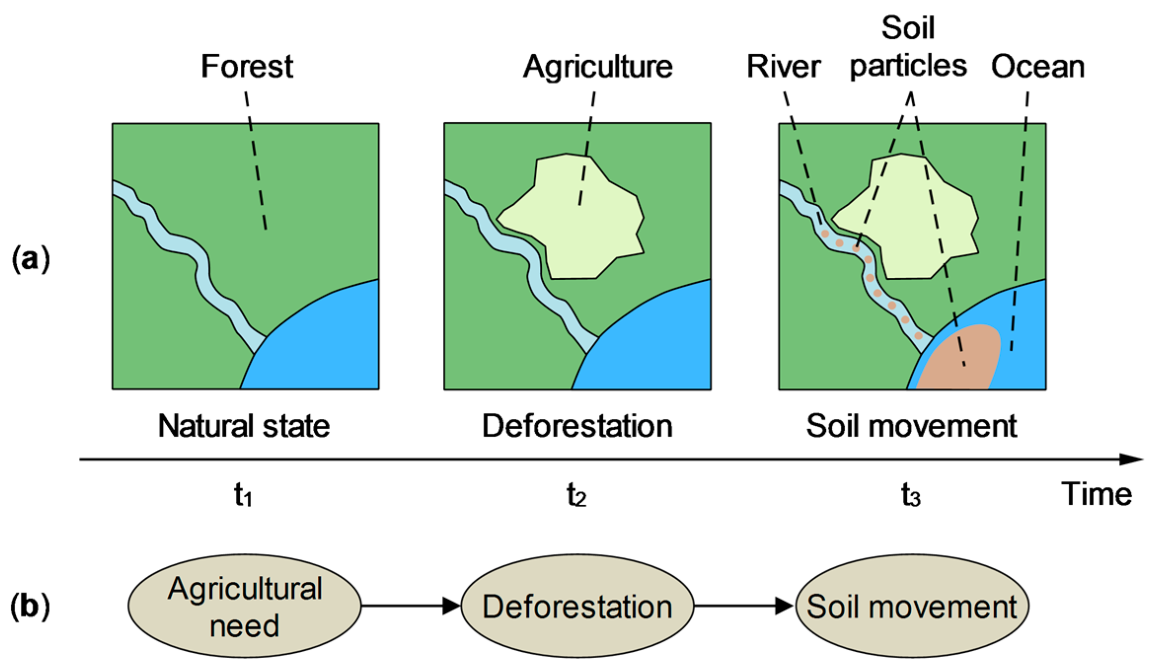
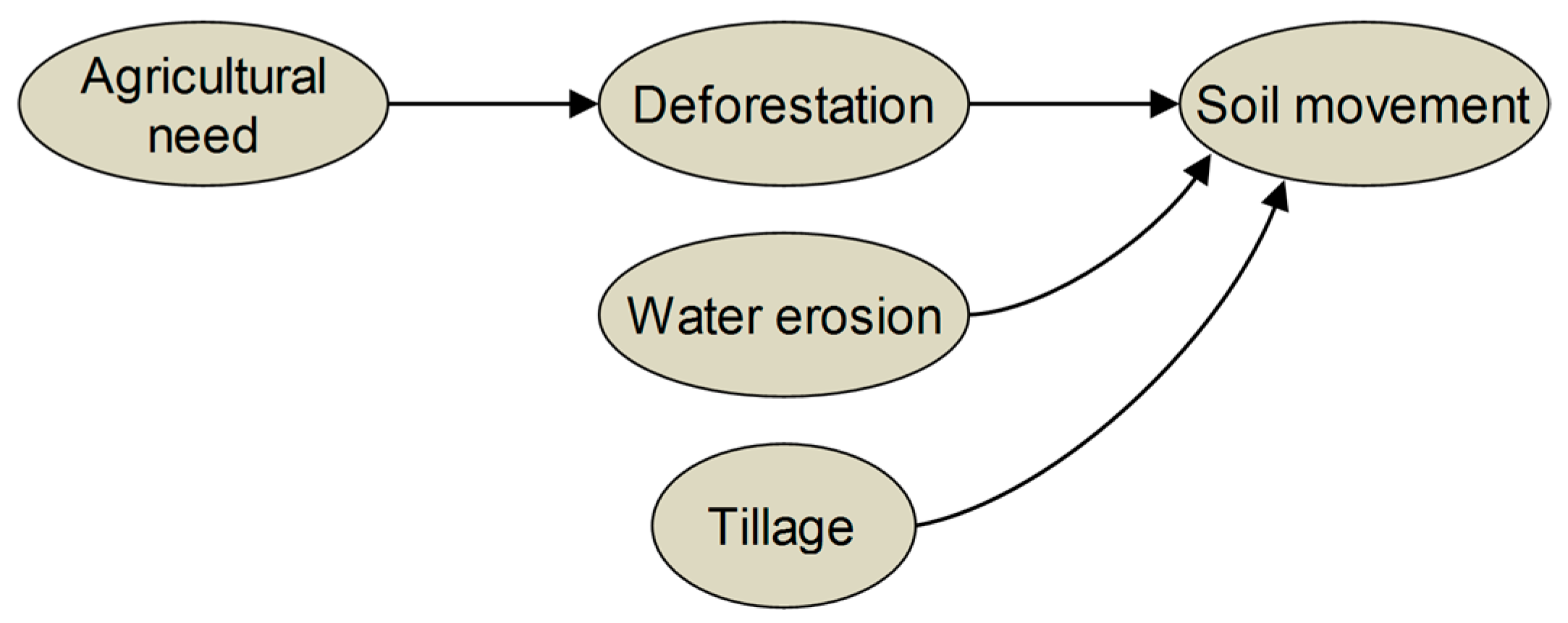
3.6.4. Examples of Causality Modeling in Geographic Sciences

Level 3 spatial-temporal models focus on modeling change using the concepts of state, event, and process, sometimes without clearly defining these three concepts. However, we saw earlier that the concepts of event and process play a significant role in the modeling of causality. Thus, the integration of the concept of cause requires such a model to clarify these definitions, as well as the nature of the causal relations that exist between the different elements. Among the different models of cause, the work of Galton et al. has particularly drawn our attention. Indeed, the proposed models define these concepts in a relevant way. Moreover, although the models developed by Galton are theoretical, they have also been implemented (see page 24).
In the first modeling, Galton and Worboys [171] proposed a generic ontology about processes and events with a set of terms for the causal relations (Figure 18). In this ontology, events are delimited episodes in the unchanging historical record, and processes are dynamic phenomena that exist in the present and that are subject to change as time passes. The state refers either to the state of an object or the state of a process. The condition of a state can allows or prevents an event from occurring: it is a necessary precondition for the realization of the causal relation. For example, the breach of a poorly maintained river dyke may lead to flooding. In this case, the cause of the flooding is not the dyke, but rather the condition of the object that allowed the flooding to occur. The cause of the breaking event is due to the lack of maintenance of the dike. In this model, causality is considered as a chain reaction of events. It appears that only events can cause other events. The states (objects and processes) interact together but at another level. For example, the breach in the dyke perpetuates the flooding.
In another contribution, Galton [102] proposes an improvement of his model by adding causal and causal-like relations. According to Galton, the causal relation itself is not expressive enough to represent the entire chain of dependencies, as many involved state. So, causal-like relations serve to improve the expressiveness of modeling. These relations include initiates, terminates, and allows, as can be seen in Figure 19.
Unlike the 2005 ontology (Figure 18), Galton separates the concepts of the object from that of the process which results in a more comprehensive model depicted in Figure 20. In this ontology, an event is defined as a temporally bounded occurrence typically involving one or more participants undergoing motion or change. Usually, the event results in at least one participant being in a different state at the end and at the beginning of the event. A process has a greater affinity with states. It is an “open-ended, homogeneous activity” [102], such as a person’s writing, the falling of the rain, or the ongoing process of plant photosynthesis. A process might be described as a dynamic state—a state of change, involving continuous change. Additionally, Galton points out that his processes are equivalent to the activities in Vendler’s classification [190].
We can observe a certain symmetry between events and processes. Thus, only events can cause other events. Similarly, processes can perpetuate other processes. States allow events to cause other events or processes to perpetuate other processes. Events may initiate or terminate states and processes may terminate states. Thus, states cannot be causes, having instead an enabling role in relation to causation and perpetuation. We can also notice that compared to the 2005 model (Figure 18), negative relations such as prevents, disables, or disallows are no longer represented in the 2012 model. This is because, according to Galton, negative relations belong to the realm of explanation and not to the realm of causal explanations. One should note that Galton’s 2012 model [102], although theoretical, has subsequently been applied to real geographic data sets [172,173,191].
Finally, Galton provides a new iteration of his process/event/cause model in [104] by including the concept of Eventuality. This concept is used as a general abstraction to cover everything that takes place over time in terms of change, which essentially includes the three concepts related to change, namely, state, process, and event.

3.6.5. Analysis

Overall, a close look at the notion of causality and how it is defined and characterized, particularly in philosophy and science, reveals the following elements. Philosophy provides different definitions and interpretations, sometimes contradictory, of the cause term. The sciences, relying on experimentation to develop laws and theories, use the cause as a tool to help validate initial hypotheses. However, we note that these different visions (philosophy and sciences) are not systematically in disagreement, it is often a choice of terms and definitions rather than a question of the underlying concepts. Moreover, we can notice that the work of Galton et al., especially [102,104,171], relies on concepts developed both in philosophy and science in order to provide models as universal as possible. Next, we outlined the concepts related to the cause as they are currently represented within GIScience. We have also described some models dedicated to the representation of the cause.
Based on this, one can make a few observations:
  • The cause is a challenging concept to model. Indeed, the various causality models and the few given examples indicate that this concept is relatively delicate to model. One of the difficulties may be that identical facts can be interpreted differently. One should also add the complexity brought by the multiplicity of causes and effects. Indeed, an effect is often the result of several causes or a series of nested causes.
  • The cause is closely related to the concepts of event and process. Indeed, the event (or the process) can be considered as the element that produces the cause. In this case, the cause serves, for example, as a justification for the occurrence of a geographical phenomenon. Therefore, the use of the concept of causality can only be fully realized through a model that explicitly manages the events (and/or processes). We can cite Galton’s models as an example (Section 3.6.4).
  • Causal relations can improve the representation of interactions between geographic phenomena. Causality represents a form of interaction between different processes that act on geographic objects. Studying these interactions is essential for a better understanding of the real world. It enables to build and test hypotheses, derive laws, or improve simulation models. For example, it is important for scientists to know whether two geographical processes occurring in the same spatio-temporal area can have a causal relation (e.g., when one contributes to generating the other).
  • Causal modeling can be useful in the area of decision-making. Since the causal relationship is unidirectional, causes can be inferred from effects. This helps, among other things, to improve the understanding of the origin of changes. Thus, the study and modeling of causes can help to deduce or predict future changes. For example, a spatio-temporal GIS capable of reconstructing a causal chain would allow the user to anticipate or accurately assess the possible consequences of an action, a process, or the occurrence of an event on the evolution of the studied geographical phenomenon.
  • Causal relations must be interpreted in a context. As Allen [169] points out, causal relations are more a matter of human perception than real-world properties. As such, they are highly subject to interpretation. For this reason, causal relations only hold in relation to the context in which they occur. Ideally, a comprehensive causal model should provide mechanisms to represent knowledge about the involvement of agents in cause-effect relationships.
  • The concept of causality is under-exploited. Despite convincing results such as the work of Mau et al. [186] or the one of Bleisch et al. [172,191], the concept of causality is currently under-exploited in actual spatio-temporal models. More recently, Ghazouani et al. [192] have shown, through a practical case, that the modeling of causes allows for the interpretation of the consequences of geographical phenomena. However, current spatio-temporal models represent causality in a relatively simple way without considering all the related concepts. We believe that it is possible to improve this representation by integrating the previously mentioned concepts such as the notions of direct and indirect causes or temporal constraints. Moreover, the expressiveness of the model would also be improved by integrating the concepts developed by Galton [102,104].

3.7. Level 6: Allowing for Multiple Interpretations

Level 6 takes the multiple interpretations into account. Indeed, the observed reality is perceived and understood differently by each person. As a result, information must be interpreted in the context and point of view of everyone. In addition, interpretations are made for a specific purpose based on a variety of contextual elements.
In the previous sections, we saw that the concepts of identity and causality are closely related to the concept of interpretation. Indeed, the concept of identity depends on the users’ point of view, while causality relations are valid only in the context in which they have been defined. However, the use of interpretation has a much broader scope. The main benefit of interpretation appears, for example, in the context of the historical study of the city, or in urban planning. In these two examples, interpretation could help to characterize several alternative descriptions regarding that urban evolution.
Historical studies are facing the high complexity of any data that ought to be analyzed. They come from various sources, are heterogeneous, imprecise, and present uncertain reliability. In studies of urban transformations, a historian is often led to make a few transformation assumptions for the same building. In the case of city planning, an urban planner is faced with the task of formulating and considering several future development scenarios [193]. Different requirements should be taken into consideration, including housing, transportation, urban design, community facilities, economic development, zoning, and land use regulations, etc.. People working on the same project such as architects, geographers, sociologists, economists, politicians may come from different disciplines, leading them to approach the peculiarities of a planning project according to their own methodological approaches.
According to the Collins Dictionary, “an interpretation of something is an opinion about what it means” [194]. Interpretation serves to confer meaning and generally allows oneself to consider usually more than one option. Furthermore, an opinion must be understood in its context. Under these conditions, interpretation is defined as a point of view in a particular context.
The notions of interpretation, context, and point of view are scarcely developed in the geographic sciences, at least as we conceive them. Therefore, we rely on research conducted in other areas in order to further define these concepts. In this section, we define the concepts of interpretation, context, and point of view. Moreover, the notions of context and point of view being relatively close, we also bring clarification between these two concepts.

3.7.1. Interpretation Concept

In order to define interpretation, we choose to approach this notion in the same way as it is addressed in history and urban archaeology. Due to the large amount of spatial data involved, the study of buildings and their evolution is a topic that has traditionally been carried out by geographical sciences.
In studies of historical buildings, the information related to previous states is often contradictory, heterogeneous, uncertain, and incomplete [195]. Thus, incomplete information provided by historical sources must be interpreted by experts. To reconstruct past states, historians and archaeologists use several reasoning methods to formulate their working hypotheses: mainly deduction and analogy [196]. The deduction relies on incomplete elements (e.g., field observations, building plans, etc.) in order to reconstruct a whole. The analogy is based on reference documentation, techniques applied at that period, or similar constructions near the study site. Each missing piece of information opens possibilities for multiple interpretations.
Data interpretation can also be addressed under the two following aspects: explanation and meaning. “Explaining is to understand through causes” [197]. Causality is concerned with the handling of relationships between phenomena. By exploring causes, it is possible to guide the selection of one or other perspectives in the case of multiple solutions. The meaning is about making sense, and about the questioning that underpins the possibly many denotations that are identified during the analysis. The meaning is specific to the context being studied.
Past state reconstruction involves a phase during which available data is interpreted. The interpretation is usually done by a group of experts, each formulating their own version of past facts. Thus, the assumptions formulated during the interpretation phase are not necessarily consensual. Whenever we use the term “interpretation”, Saitta suggests the expression of “realist alternatives”. Indeed, it must be recognized that, even if empirical reality constrains what can be expressed about the past, there is still plenty of free space for interpretation. Saitta [198] gives several explanations. First, knowledge is constructed and produced from particular social points of view resulting from interpretative and subjective reasoning. Second, archaeological data requires several interpretations to make them match with archaeological facts and logical consistency. He suggests an anti-fundamental notion of truth: “the idea that there are no fixed, stable grounds on which knowledge claims can be established” [198]. Truth is not an exact reflection of something external to human beings. Instead, it is rather an intersubjective consensus among human beings, driven by the theories, methods, and data currently available. The objective is therefore to be able to characterize these different interpretations.
Moreover, according to Grataloup [199], representations, whether spatial or temporal, only make sense in a given social context and are limited to a particular time period. For example, the same word used in a different context or at a different time may have a completely different meaning. For example, in 1860, the city of Paris annexed eleven towns [200]. In this case, the term “city of Paris” no longer refers to the same geographical area before and after the annexation, yet the name of the city remains unchanged. On another scale, the territorial limits of the United States of America have also changed since 1776. Differences can also be found at the temporal level, for example, the official date of the end of World War II varies among countries.
Therefore, the context in which data is produced is important, as well as the environment in which it is interpreted. The conditions under which the study is carried out and information concerning the person working on that data must therefore be integrated into the system. This is particularly the case when the interpretation and data analysis vary from one school of thought to another as well as from one person to another. Thus, American, French, German, or Russian historians may hold different perceptions and interpretations of historical facts due to different schools of thought. Although our examples are in history, they are still true in other fields. For example, in the case of urban planning mentioned earlier, the way of perceiving transportation management is different in Europe, Japan, and the United States of America. In physical geography, we can also mention the coastal dynamics modeling approach, which varies according to available data and the processing methods applied to studying this phenomenon. Generally, in the case where several experts work together, it is interesting to model the multiple perspectives the experts can have on the objects manipulated in their reasoning. This perspective concept is called a point of view and has been used for a long time in the field of knowledge representation [201]. In GIS, the introduction of the social perspective requires closer attention to the issues of subjective perceptions and multiple views of the same spatio-temporal phenomenon [202]. Indeed, different participants in the same study do not always have the same understanding of the world.

3.7.2. Notion of Context

As mentioned in the introduction, interpretation is made in context. In this section, we provide a general definition of context, then we focus on two more specific definitions that are commonly accepted, namely the context defined by specific entities and the formal approach.
Context definition
The notion of context has been particularly studied in the field of ubiquitous computing systems. In the early 1990s, the emergence of mobile technologies led to the possibility of customizing the information received by the user according to his physical environment [203].
The term “context-aware” appeared in 1994 [204]. Context is then used to define the status of an environmental entity. An entity could be a person, a place, an object, an application, or a computing device that is considered relevant to the interaction between a user and an application, including the user and applications themselves [205,206,207,208]. Over the past two decades, context-aware computing research has evolved from desktop applications, mobile computing, ubiquitous computing to the IoT [209,210]. Thus, many studies have investigated the concepts of context and context-aware and many definitions have been proposed in the area of computer science. The definitions of context found in literature can be divided into two main categories (There are other ways to categorize the different definitions of context. Perera et al. [209] as well as Pradeep and Krishnamoorthy [210] each provide a list of main classifications.): those who define context by specific entities (location, time, etc.), and those that determine context from a more conceptual perspective by focusing on the relationships and structure of contextual information [211]. This perspective is referred to as the formal approach.
Context defined by specific entities
The term “context-aware” was first used by Schilit and Theimer [204] in 1994. They defined the context as the location, identities of nearby people, objects, and changes to those objects. Later, Schilit et al. [212] extended the notion of context to other entities. Thus, three aspects of context are: where you are (user’s location), who you are with (social situation), and what resources are nearby (computer equipment, buildings, etc.). In both cases, it is a question of qualifying the environment close to the user. Based on this work, other definitions of context-aware emerged. For example, Ryan et al. [213] characterize context through information about the environment, such as location, time, temperature, or user identity. Brown et al. [214] consider information related to the user’s context to be the location, the people around the user, the time of day, the season of the year, the temperature, etc. The list of projects using context by enumerating examples is quite large. An overview of some of these projects can be found in [215]. In addition, much of the literature on context deals with the adaptation of information provided to users according to their context. Strang and Linnhoff-Popien [216] provide a state of the art in this regard, as well as Bettini et al. [217].
In the field of geographic sciences, studies on the notion of context mainly concern mobile applications and also refer to the concept of context-awareness (e.g., [218,219,220]). In these studies, the aim is generally to display relevant information to users according to their context. In this case, this context is perceived as the user’s immediate environment. For example, in the case of a navigation app, the information displayed to the user changes depending on the location. When the user is driving a car, the application displays the position of gas stations and traffic info onto the map. When the user leaves the car and is walking, the application displays bus stops and subway stations.
We are not completely satisfied with this first way of defining the context. Indeed, in these approaches, the notion of context is essentially limited to the user’s physical environment, whereas it could be extended to incorporate the research environment and methodology in which the study is carried out.
Formal approach
At the end of the 1990s, a new way of defining context emerged: the formal approach. Context is seen here as some particular type of information. Brézillon and Pomerol argue that no type of knowledge can be objectively called context: “[…] it appears that knowledge that can be qualified as ″contextual″ depends on the context” [221]. Nevertheless, some researchers attempt to define the notion of context more formally. Dey and Abowd’s definition is probably the most widely accepted “Context is any information that can be used to characterize the situation of an entity. An entity is a person, place, or object that is considered relevant to the interaction between a user and an application, including the user and applications themselves” [205]. We also retain this definition, although it is dedicated to software development, it remains sufficiently broad. Subsequently, other formal definitions of context have been formulated; we can retain the work of Henricksen et al. [222] or that of Zimmermann et al. [223]. Moreover, we agree with the view of Brézillon and Pomerol [221], also shared by Wang et al. [224], that the context to be taken into consideration varies from one field of study to another.
The definition and use of context are part of a relatively vast area of study that has notably evolved over the last thirty years. For any further and detailed information, the interested reader can refer to Dey and Abowd’s articles [205,225]. Although old, these are a good starting point. In addition, several surveys such as [215] that we mentioned earlier, but also [226] are relevant as well. More recent studies focus mainly on the modeling and implementation of the context concept. These are gradually shifting towards the use of context within IoT environments [209,217,227,228]. The two more recent surveys are those of Pradeep and Krishnamoorthy [210], and Matos et al. [208].

3.7.3. Notion of Point of View

As mentioned above, when several experts are working on the same information, it is necessary to handle the diversity of perceptions and opinions. Each expert may have a particular perspective on their subject of interest. It may vary according to his or her area of expertise and experience. In general, it is difficult to develop a single model that takes the views of all experts into account. Throughout the problem-solving process, this can lead to different understandings of the same topic and a divergence in the following analysis. Unlike an approach revolving around a single point of view, the multi-point of view approach gives the possibility to model the same reality by integrating different points of view. The aim is to represent (aggregate) the multiple descriptions and interpretations of the same object or event by the experts.
Characteristics of the point of view
In everyday language, a “point of view” literally is a place from which an observer looks at the landscape. The observer only sees the surface of the object facing him. In the figurative sense, the point of view is the expression of an opinion on a particular subject [229]. Thus, the characteristics of the point of view depend on the angle from which the subject is approached [230]. The expressions on the subject are relevant and valid only from a given point of view. For these reasons, they may be different, or even contradictory, if they emanate from another point of view [230]. A point of view corresponds to a context or a situation that is based upon the knowledge of an object or entity [231]. The associated assertions are expressed and considered valid and true according to this point of view [231]. The point of view can be associated with a person or a group of persons, but also with a theoretical context that defines a framework by which the world is perceived or conceptualized [231].
Models including the notion of point of view
The notion of point of view is discussed by several authors in diverse disciplines. Whereas, few works in GIScience focus on the notion of point of view. However, we can mention those of Spaccapietra et al. [232] or Galton [41] which briefly treat the question of point of view. More recently, Samuel et al. [233] propose a solution to represent possibly concurrent hypotheses in urban evolution. Parent et al. [234], in their work on MADS, also evoke the notion of point of view and conclude that the scope of such a problem goes beyond that of a conceptual model like MADS. Thus, based on the research paths suggested by Parent et al., we turn to other areas of research and more particularly to the field of knowledge representation where the notion of point of view has been strongly developed for several decades. Finally, this review of the bibliography is quite extensive, so we exclude the concept of view [235] as it is commonly used in the domain of databases. In the field of computer science, the point of view has found multiple practical applications: databases, knowledge representation, analysis and design, software development process, programming languages, software engineering tools, etc. [236]. Most of these employ the notion of point of view independently, which leads to a variety of terms such as perspective, context, opinion, view, and roles [237]. This terminological diversity generates multiple definitions around the notion of point of view. The point of view can be considered as a form of knowledge since it is an aspect or a cognitive layer that is added to an observation in a given context. In the following paragraphs, we discuss the main articles expressing the notion of point of view, and more particularly those related to the modeling and formalization of knowledge.
One of the first references to the notion of point of view was written by Minsky in 1974 [238]. He introduced the concept of perspective (synonymous of point of view) corresponding to the different perceptions of the same object by different observers according to their spatial placements. Thus, since the 1970s, several systems explicitly integrating the notion of point of view have been proposed. We find a whole set of systems, models, and languages, such as KRL [239], which is one of the first languages dedicated to the multi-viewpoints representation of knowledge. The 1980s have seen the emergence of LOOPS [240], which we can consider as a derivative of KRL, and VIEWS [241], which combines the ideas of frames and semantic networks.
The early 2000s represent a turning point in the representation of knowledge, especially with the increase in the use of ontologies. In this context, we can, for example, cite the work of Falquet and Mottaz [242] on multi-viewpoints ontologies. As part of the design of a terminological knowledge base, Falquet and Mottaz Jiang propose a model based on descriptive logic for the representation of knowledge using multi-viewpoints. In a multi-viewpoints ontology, each concept can have several definitions, each of which represents the particular point of view of an expert. The aim of this kind of model is to produce an ontology where, for each concept, there is a maximum of one definition per point of view. However, the model designed by Falquet and Mottaz Jiang is not able to handle the conflict between two points of view within the same conceptualization. To overcome this weakness, Falquet and Mottaz Jiang subsequently developed a method for analyzing and resolving conflicts of opinion [243,244]. Other articles focus on the use of Semantic Web technologies such as RDF or OWL. C-OWL [245,246] is an OWL-based formalism for the representation of contextualized ontologies. C-OWL is, for example, applied in the KASIMIR project [247], an application dedicated to knowledge management for decision-making in medicine. In 2006, Bach [229] continued along the path of the Semantic Web and proposed a model, named MPV, for the representation of multi-viewpoints ontologies and the associated ontology language, MVP-OWL, extending the OWL language. To do this, Bach based his work on the World Wide Web Consortium (W3C) standards as well as on the one of Ribière [248]. He introduced a new ontological entity called a point of view in addition to the classical entities (class, property, and instance). In the field of Socio-Semantic Web research, several approaches deal with the collaborative structuring or the semantic enrichment of concepts used for annotation. For example, in 2005, the HyperTopic model [249,250] extended the Topic Maps formalism, taking into account several points of view. In 2010, SRTag [231] appeared; it is a multi-point of view model for the semantic enrichment of folksonomies (A folksonomy is a collection of terms based on data from non-specialists. It is opposed to taxonomies made by experts in a domain [251].), which enable the modeling and detection of conflicts between points of view. Finally, we can also cite Zemmouri’s model [236], which is used to formalize the knowledge employed by analysts (experts) during the process related to the extraction of knowledge from data. There is also the CRMinf extension of the CIDOC CRM [252,253], an ontology dedicated to cultural heritage, as well as the Event-Model-F model [254], which provides mechanisms to model the point of view.

3.7.4. Context and Point of View

The notion of context, as considered in the domain of knowledge representation, is remarkably close to the one of point of view [229,246,247]. Thus, the difference between these two terms requires some clarifications.
Benerecetti et al. [255] enumerate three forms of context in the field of knowledge representation: (1) The context can correspond to a part, a partial view of a set of elements or a domain. Knowledge representation is partial when it describes a subset of knowledge of the domain; (2) The context represents an approximation. Knowledge representation is approximate when it summarizes some aspects of the elements to be represented. The notion of approximation is conceived in relation to another approximation. There are, in fact, different levels of modeling of reality, which results in multiple degrees of granularity or abstraction; (3) A context is equivalent to a perspective. The representation of knowledge is then perceived according to different perspectives that depend on external elements such as location, time, observer perception, etc.
According to the vision of Benerecetti et al. [255], we can establish that the notion of context is more general than the one of point of view. Based on this observation, Aquin [255] suggests the following analysis: in a set of contexts, two contexts are differentiable by the fact that they focus on different parts of the domain, according to different levels of approximation or from different perspectives. Under these conditions, the notion of point of view is fully integrated into the one of context. Hence, a point of view becomes a partial view, defined in relation to an external objective in the presence of other representations.

3.7.5. Synthesis

In the above sections, we outlined the concepts of interpretation, context, and point of view. Unlike the previous levels, this section is more a state-of-the-art than an analysis of different models. We note that no existing model completely satisfies us. A more detailed analysis of these models would require further developments which go beyond the scope of this article. To conclude this section, we make a synthetic analysis of models that include the notion of point of view.
In terms of modeling, the concept of point of view is an elegant way to represent a simplified version of knowledge specific to an agent. As described above, the work in the literature on knowledge representation mainly concerns the elaboration of thesauruses or ontologies. In practice, the object is to obtain consensual descriptions of the same object (in the sense of a concept or group of concepts) by different experts. However, our need is to be able to characterize the experts’ opinions on an object, an event, etc. It is not a question of reaching a consensus, but of highlighting differences. As a result, the current models do not meet our requirements. Moreover, the plurality of approaches shows that the notion of point of view, although appearing quite simple, is particularly difficult to formalize.

4. Discussion

In this section, we bring an analytical overview of our classification embodied by our pyramidal framework. Indeed, as any classification is suggestive, we would like to clarify some aspects.
The choice of levels may vary according to the needs of the research and the studied geographical objects. For example, to monitor land cover changes (e.g., the evolution of forests, urbanization), a level 1 model such as the sequential snapshots model [17,72] is relatively well-adapted, for instance, by using temporal snapshots from satellite imagery each year and comparing the images. But, if we want to follow the evolution of a building, a level 2 or 3 model is more suitable. Besides, in a case where a large part of the data is missing, such as urban archaeology, the spatio-temporal model must include the interpretation functionalities of level 6. With regards to the sequencing of the different levels, the first three levels correspond to the most primary needs. They are inspired and adapted from the work of Worboys [2]. Their order is quite obvious and generally accepted. Considering the next three levels, namely identity, causation, and interpretation, we note the following:
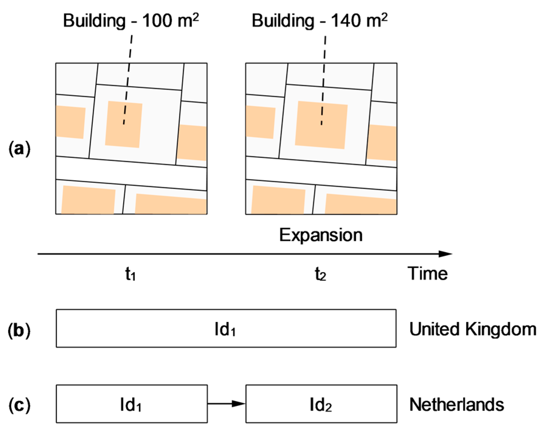
  • Identity is a key element in keeping track of the evolution of objects, so it naturally complements the first three levels. Furthermore, the need for causality and interpretation generally requires advanced identity management. Identity must therefore be explicitly expressed to take full advantage of these two upper levels. Moreover, fine-grained identity management will facilitate the encoding of filiation relationships. It will therefore help to better detect or improve the understanding of the data evolution.
  • Causality is a notion that allows a set of concepts such as process, event, state, and object to be assembled, with links between them. Thus, the cause must be placed at least after the explicit representation of phenomena. This type of representation is still a challenge since few spatio-temporal models explicitly exploit this concept. Moreover, with better integration and use of the concept of causality, several spatio-temporal analyses can be derived and further developed. For example, the spatio-temporal relationships between oceanic eddies and tropical cyclones could be characterized differently (this example is inspired by [256]). In addition, representing geographic information in the form of causal chains could significantly improve the spatio-temporal visualization of complex geographic phenomena.
  • Interpretation constitutes an interesting level for the following cases:
    -
    The first case is when we do not know precisely what happened. Indeed, historical events are subject to interpretation. Thus, making a few hypotheses is often necessary to reconstruct past states. This is the typical case of urban archaeology that we mentioned previously. For example, experts seek to reconstruct the changes that a building has undergone over time. However, they do not know precisely what happened, as information is missing. Thus, each expert proposes a solution that may be different from one another. Sometimes the answers are complementary, sometimes they are conflicting.
    -
    This second case is like the first one, but the purpose is to represent hypotheses of future evolution. Indeed, a spatio-temporal model is not necessarily limited to past data. For example, in the context of urban planning, it is essential to handle multiple scenarios of future city developments, as well as to process projected data.
    -
    The third case concerns experts from different domains who need to model their diverse points of view on the studied objects. The interpretation is useful to establish a consensus and identify the divergent opinions among the experts.
The classification defined in our framework is characterized by the following intrinsic properties:
  • Categories are not mutually exclusive, rather they are complementary to each other. Indeed, a spatio-temporal model can belong simultaneously to multiple levels. For example, a model could explicitly represent the type of changes together with the concepts of events/processes. In this case, such a model belongs to both levels 2 and 3.
  • Despite the existence of an interrelation between the levels, the higher levels do not necessarily include the lower levels. For example, as mentioned in Section 3.4, some level 3 models such as TEMPEST do not explicitly name transformations and therefore do not include level 2.
  • The ordering of the levels is not absolute. The pyramid is primarily to help and guide the design of new models or to enhance existing ones. For example, it can serve as a conceptual basis for the upgrade of spatio-temporal models by adding new features. The pyramid can also be considered as a reading grid to organize the spatio-temporal models. However, it should be noted that certain spatio-temporal models such as the triad framework [31] do not fit into its categories.
  • We would like to position the pyramidal framework in relation to the notion of temporal scale. Indeed, when designing spatio-temporal models, the selection of the temporal scale influences a part of the modeling choices. However, the pyramid concepts (e.g., temporal snapshots, object change, event, process, identity, causality, interpretation) can be explored at different temporal scales. For example, in the context of urban data, the concept of the event can be used to study the data at different temporal granularities. The evaluation of the impact of urbanization can be done on an annual scale (decrease of arable lands, the increase of impermeable surfaces, etc.). While in the case of Smart Cities, data can be analyzed in real-time like public transport data (bus stops and departures, road accidents, etc.). Consequently, the notion of temporal scale is more transversal and covers all the levels of the pyramidal framework.

5. Concluding Remarks and Future Research Opportunities

In this article, our objective was to provide a pyramidal framework composed of six ordered levels. The first three levels of the pyramid are based on Worboys’ terminology [2] and correspond to the three main stages through which the development of spatio-temporal modeling has evolved, namely the implicit representation of changes, the explicit representation of changes, and the explicit representation of phenomena leading to changes. The pyramid is then completed by three new levels of functionality, namely the explicit representation of identity, the explicit representation of causality, and allowing for multiple interpretations. Each of the higher levels extends the information representation, analysis, and processing capabilities of the previous levels. Since the first three levels are relatively well established and documented in the literature, we detailed them briefly. The next three levels are more deeply explored. We approached the fourth level, identity, through different positions: philosophical, geographical, and computer science. Level 5 covers the concept of causality and complements the concepts of event and process from level 3. Then we continued our discussion with level 6, interpretation. We developed the concepts of context and point of view. We concluded with an analytical overview of our classification.
The main contribution of this paper consists of providing a new lecture and classification of spatio-temporal models. The increasing amount of spatio-temporal data and the multiplication of available sources create a need for new guidelines to orient the design of future spatio-temporal models. The identified concepts help to capture the key requirements related to the modeling of complex geographic phenomena. In addition, we explain why these levels are not well exploited in the different actual solutions. We have also provided bibliographical references that might be the starting point for those who want to investigate the topics in depth.
The analyses related to the integration of the three upper levels, namely identity, causality, and interpretation, lead to the following observations:
  • In terms of identity integration:
    -
    The definition of identity must include all the constituents of the geographical object, namely spatiality, temporality, and thematic.
    -
    Imposing a pre-established list of transformations to manage identity change is insufficient for realistic modeling. Indeed, the attribution of the identity must be variable and be made according to the field of application.
    -
    The concept of identity only makes sense in a context and depends on the users’ point of view.
  • In terms of causality integration:
    -
    Lower-level models cannot track the causes behind the evolution of geographical objects. This can only be achieved by explicitly incorporate causal mechanisms.
    -
    Current spatio-temporal models represent causality in a relatively simple way without considering all related concepts. We believe that it is possible to improve this representation by integrating concepts such as direct and indirect causes, or temporal constraints. This could enhance the expressiveness of spatio-temporal modeling.
    -
    Causal relations can improve the representation of interactions between geographical phenomena. In addition, the study and modeling of causes can help deduce or predict future changes, thus causal modeling can be useful in the area of decision-making.
  • In terms of interpretation integration:
    -
    The concepts of identity and causality are intricately linked to the one of interpretation. Indeed, the concept of identity depends on the point of view of the users, and causality relations are valid only in the context in which they have been defined. However, the use of interpretation has a much broader scope.
    -
    Interpretation is particularly useful in the area of problem-solving, especially when the methods of analysis and the understanding of the same subject by different experts diverge. In this case, the point of view helps to take into account the diversity of experts’ opinions.
    -
    The interpretation is also relevant when considering different alternatives of evolution (scenarios). This is particularly valuable in the context of the historical studies of a city or in urban planning.
    -
    The concept of context is essentially limited to the user’s physical environment. It could be extended to incorporate the research environment and methodology in which the study is conducted.
We consider the pyramidal framework as a preliminary step in the conceptual modeling process. It opens a field of research on the new functionalities that the new generation of spatio-temporal models should integrate. Our next step will be to apply this framework by designing a spatio-temporal model integrating the concepts of higher levels, namely identity, causality, and interpretation. This research will be applied to the multidisciplinary field of digital humanities and more precisely to the historical evolution of the city. Such a case study contains highly heterogeneous data and requires us to take the point of view of various specialists into account. The reconstitution of past states requires us to make several interpretative hypotheses and to consider the historical context. Finally, we hope that our modeling will be able to offer new capabilities of enhancing the available data and discover new historical insights and perspectives.

Author Contributions

Design of the conceptual framework, Cyril Carré; Investigation, Cyril Carré; Writing-Original Draft Preparation, Cyril Carré, Younes Hamdani; Writing-Review & Editing Cyril Carré, Younes Hamdani. All authors have read and agreed to the published version of the manuscript.

Funding

This research received no external funding.

Institutional Review Board Statement

Not applicable.

Informed Consent Statement

Not applicable.

Data Availability Statement

Data sharing not applicable.

Conflicts of Interest

The authors declare no conflict of interest.

References

  1. Nara, A. Space-Time GIS and Its Evolution. In Comprehensive Geographic Information Systems; Huang, B., Ed.; Elsevier: Oxford, UK, 2018; pp. 287–302. [Google Scholar] [CrossRef]
  2. Worboys, M. Event-oriented approaches to geographic phenomena. Int. J. Geogr. Inf. Sci. 2005, 19, 1–28. [Google Scholar] [CrossRef]
  3. Siabato, W.; Claramunt, C.; Ilarri, S.; Manso-Callejo, M.Á. A Survey of Modelling Trends in Temporal GIS. ACM Comput. Surv. 2018, 51, 30. [Google Scholar] [CrossRef] [Green Version]
  4. Yuan, M. Temporal GIS and Spatio-Temporal Modeling. In Proceedings of the Third International Conference Workshop on Integrating GIS and Environment Modeling, Santa Barbara, CA, USA, 21–25 January 1996; pp. 21–26. [Google Scholar]
  5. Raza, A. Object-Oriented Temporal GIS for Urban Applications. Ph.D. Thesis, University of Twente, Enschede, the Netherlands, 2001. [Google Scholar]
  6. El-Geresy, B.A.; Abdelmot, A.I.; Jones, C.B. Spatio-Temporal Geographic Information Systems: A Causal Perspective. In Proceedings of the East European Conference on Advances in Databases and Information Systems, Bratislava, Slovakia, 8–11 September 2002; pp. 191–203. [Google Scholar]
  7. Pelekis, N.; Theodoulidis, B.; Kopanakis, I.; Theodoridis, Y. Literature review of spatio-temporal database models. Knowl. Eng. Rev. 2004, 19, 235–274. [Google Scholar] [CrossRef]
  8. Yuan, M.; Hornsby, K. Computation and Visualization for Understanding Dynamics in Geographic Domains: A Research Agenda; CRC Press: Boca Raton, FL, USA, 2008. [Google Scholar] [CrossRef]
  9. Goodchild, M.F. Prospects for a Space-Time GIS: Space-Time Integration in Geography and GIScience. Ann. Assoc. Am. Geogr. 2013, 103, 1072–1077. [Google Scholar] [CrossRef]
  10. Yuan, M. Space-Time GIS. In Oxford Bibliography of Geography; Warf, B., Ed.; Oxford University Press: New York, NY, USA, 2016; p. 18. [Google Scholar] [CrossRef]
  11. Tomlinson, R. A Geographic Information System for Regional Planning. J. Geogr. (Chigaku Zasshi) 1968, 78, 45–48. [Google Scholar] [CrossRef]
  12. Hägerstrand, T. What about people in Regional Science? Pap. Reg. Sci. Assoc. 1970, 24, 7–24. [Google Scholar] [CrossRef]
  13. Gadia, S.K.; Vaishnav, J.H. A Query Language for a Homogeneous Temporal Database. In Proceedings of the Fourth ACM SIGACT-SIGMOD symposium on Principles of database systems, Portland, OR, USA, 25–27 March 1985; pp. 51–56. [Google Scholar]
  14. Snodgrass, R.; Ahn, I. A Taxonomy of Time Databases. In Proceedings of the ACM Sigmod Record, Austin, TX, USA, 28–31 May 1985; pp. 236–246. [Google Scholar]
  15. Snodgrass, R.T. Temporal Databases. IEEE Comput. 1986, 19, 35–42. [Google Scholar] [CrossRef] [Green Version]
  16. Gadia, S.K.; Yeung, C.-S. A generalized model for a relational temporal database. ACM SIGMOD Rec. 1988, 17, 251–259. [Google Scholar] [CrossRef]
  17. Langran, G.; Chrisman, N.R. A Framework for Temporal Geographic Information. Cartogr. Int. J. Geogr. Inf. Geovisualization 1988, 25, 1–14. [Google Scholar] [CrossRef]
  18. Langran, G. A review of temporal database research and its use in GIS applications. Int. J. Geogr. Inf. Syst. 1989, 3, 215–232. [Google Scholar] [CrossRef]
  19. Langran, G. Issues of Implementing a Spatiotemporal System. Int. J. Geogr. Inf. Sci. 1993, 7, 305–314. [Google Scholar] [CrossRef]
  20. Kay, A.C. The early history of Smalltalk. In Proceedings of the Second ACM SIGPLAN Conference on History of Programming Languages, Cambridge, MA, USA, 20–23 April 1993; pp. 511–598. [Google Scholar]
  21. Capretz, L.F. A brief history of the object-oriented approach. ACM Sigsoft Softw. Eng. Notes 2003, 28, 6. [Google Scholar] [CrossRef] [Green Version]
  22. Black, A.P. Object-oriented programming: Some history, and challenges for the next fifty years. Inf. Comput. 2013, 231, 3–20. [Google Scholar] [CrossRef]
  23. Egenhofer, M.J.; Frank, A.U. Object-oriented databases: Database requirements for GIS. In Proceedings of the International Geographic Information Systems (IGIS) Symposium (IGIS’87), Arlington, VA, USA, 15–18 November 1987; pp. 189–211. [Google Scholar]
  24. Egenhofer, M.J.; Frank, A.U. Object-Oriented Modeling in GIS: Inheritance and Propagation. In Proceedings of the Ninth International Symposium on Computer-Assisted Cartography—Auto-Carto 9, Cartography, Baltimore, MD, USA, 2–7 April 1989; pp. 588–598. [Google Scholar]
  25. Egenhofer, M.J.; Frank, A. Object-Oriented Modeling for GIS. J. Urban Reg. Inf. Syst. Assoc. 1992, 4, 3–19. [Google Scholar]
  26. Price, S. Modelling the temporal element in land information systems. Int. J. Geogr. Inf. Syst. 1989, 3, 233–243. [Google Scholar] [CrossRef]
  27. Worboys, M.F.; Hearnshaw, H.M.; Maguire, D.J. Object-oriented data modelling for spatial databases. Int. J. Geogr. Inf. Syst. 1990, 4, 369–383. [Google Scholar] [CrossRef]
  28. Worboys, M.; Hearnshaw, H.; Maguire, D. Object-oriented data and query modelling for geographical information systems. In Proceedings of the Fourth International Symposium on Spatial Data Handling, Zurich, Switzerland, 23–27 July 1990; pp. 679–688. [Google Scholar]
  29. Worboys, M.F. Object-oriented approaches to geo-referenced information. Int. J. Geogr. Inf. Syst. 1994, 8, 385–399. [Google Scholar] [CrossRef]
  30. Wachowicz, M. Object-Oriented Design for Temporal GIS; CRC Press: London, UK, 1999. [Google Scholar] [CrossRef]
  31. Peuquet, D.J. It’s About Time: A Conceptual Framework for the Representation of Temporal Dynamics in Geographic Information Systems. Ann. Assoc. Am. Geogr. 1994, 84, 441–461. [Google Scholar] [CrossRef]
  32. Yuan, M. Wildfire conceptual modeling for building GIS space-time models. In Proceedings of the GIS/LIS’94, Phoenix Civic Plaza, Phoenix, AZ, USA, 25–27 October 1994; pp. 860–869. [Google Scholar]
  33. Peuquet, D.; Wentz, E. An approach for time-based analysis of spatiotemporal data. In Proceedings of the 6th International Symposium on Spatial Data Handling, Edinburgh, UK, 5–9 September 1994; pp. 489–504. [Google Scholar]
  34. Peuquet, D.J.; Duan, N. An Event-Based Spatiotemporal Data Model (ESTDM) for Temporal Analysis of Geographical Data. Int. J. Geogr. Inf. Syst. 1995, 9, 7–24. [Google Scholar] [CrossRef]
  35. Claramunt, C.; Thériault, M. Managing Time in GIS: An Event-Oriented Approach. In Recent Advances in Temporal Databases; Springer: London, UK, 1995; pp. 23–42. [Google Scholar] [CrossRef]
  36. Renolen, A. History graphs: Conceptual modeling of spatio-temporal data. GIS Front. Bus. Sci. 1996, 2, 46. [Google Scholar]
  37. Renolen, A. Conceptual Modelling and Spatiotemporal Information Systems: How to Model the Real World. In Proceedings of the SCANGIS’97: 6th Scandinavian Research Conference on Geographical Information Systems, Stockholm, Sweden, 1–3 June 1997; pp. 1–22. [Google Scholar]
  38. Renolen, A. Modelling Spatiotemporal Information: The Spatiotemporal Object Model; Norwegian University of Science and Technology: Trondheim, Norway, 1997; Available online: http://citeseerx.ist.psu.edu/viewdoc/summary?doi=10.1.1.56.3334 (accessed on 21 March 2021).
  39. Renolen, A. Concepts and Methods for Modelling Temporal and Spatiotemporal Information; Norwegian University of Sciences and Technology: Trondheim, Norway, 1999; Available online: www.emap.no/docs/ThesisAgnarRenolen.pdf (accessed on 21 March 2021).
  40. Galton, A. Space, Time, and the Representation of Geographical Reality. Topoi 2001, 20, 173–187. [Google Scholar] [CrossRef]
  41. Galton, A. Desiderata for a Spatio-temporal Geo-ontology. In Proceedings of the International Conference on Spatial Information Theory, Kartause Ittingen, Switzerland, 24–28 September 2003; pp. 1–12. [Google Scholar]
  42. Peuquet, D.J. Representations of Space and Time; Guilford Press: New York, NY, USA, 2002. [Google Scholar]
  43. Hornsby, K.; Egenhofer, M.J. Identity-based change: A foundation for spatio-temporal knowledge representation. Int. J. Geogr. Inf. Sci. 2000, 14, 207–224. [Google Scholar] [CrossRef]
  44. Grenon, P.; Smith, B. SNAP and SPAN: Towards Dynamic Spatial Ontology. Spat. Cogn. Comput. 2004, 4, 69–104. [Google Scholar] [CrossRef] [Green Version]
  45. Antidode 9. ontologie. In Dictionnaire des définitions; Druide: Montreal, QC, Canada, 2015.
  46. Tryfona, N.; Jensen, C.S. Conceptual Data Modeling for Spatiotemporal Applications. Geoinformatica 1999, 3, 245–268. [Google Scholar] [CrossRef]
  47. Frank, A.U. Ontology for Spatio-temporal Databases. In Spatio-Temporal Databases; Springer: Berlin, Germany, 2003; Volume 2520, pp. 9–77. [Google Scholar]
  48. Bittner, T.; Donnelly, M.; Smith, B. A spatio-temporal ontology for geographic information integration. Int. J. Geogr. Inf. Sci. 2009, 23, 765–798. [Google Scholar] [CrossRef] [Green Version]
  49. Janowicz, K.; Scheider, S.; Pehle, T.; Hart, G. Geospatial semantics and linked spatiotemporal data—Past, present, and future. Semant. Web 2012, 3, 321–332. [Google Scholar] [CrossRef] [Green Version]
  50. Miller, H.J. The data avalanche is here. Shouldn’t we be digging? J. Reg. Sci. 2010, 50, 181–201. [Google Scholar] [CrossRef]
  51. Manyika, J.; Chui, M.; Brown, B.; Bughin, J.; Dobbs, R.; Roxburgh, C.; Hung Byers, A. Big Data: The Next Frontier for Innovation, Competition, and Productivity; McKinsey Global Institute: Washington, DC, USA, 2011; Available online: https://www.mckinsey.com/business-functions/mckinsey-digital/our-insights/big-data-the-next-frontier-for-innovation (accessed on 21 March 2021).
  52. Sagiroglu, S.; Sinanc, D. Big data: A review. In Proceedings of the 2013 international conference on collaboration technologies and systems (CTS), San Diego, CA, USA, 20–24 May 2013; pp. 42–47. [Google Scholar]
  53. Kitchin, R. Big Data, new epistemologies and paradigm shifts. Big Data Soc. 2014, 1. [Google Scholar] [CrossRef] [Green Version]
  54. Elwood, S.; Goodchild, M.F.; Sui, D.Z. Researching Volunteered Geographic Information: Spatial Data, Geographic Research, and New Social Practice. Ann. Assoc. Am. Geogr. 2012, 102, 571–590. [Google Scholar] [CrossRef]
  55. Spinsanti, L.; Berlingerio, M.; Pappalardo, L. Mobility and Geo-Social Networks. In Mobility Data: Modeling, Management, and Understanding; Cambridge University Press: New York, NY, USA, 2013; pp. 315–333. [Google Scholar] [CrossRef]
  56. Evans, M.R.; Oliver, D.; Yang, K.; Zhou, X.; Ali, R.Y.; Shekhar, S. Enabling Spatial Big Data via CyberGIS: Challenges and Opportunities. In CyberGIS for Geospatial Discovery and Innovation; Wang, S., Goodchild, M.F., Eds.; Springer: Dordrecht, The Netherlands, 2019; pp. 143–170. [Google Scholar] [CrossRef]
  57. Lohr, S. The Age of Big Data. New York Times, 11 February 2012. [Google Scholar]
  58. Michael, K.; Miller, K.W. Big Data: New Opportunities and New Challenges. Computer 2013, 46, 22–24. [Google Scholar] [CrossRef]
  59. Van den Dam, R. Internet of Things: The Foundational Infrastructure for a Smarter Planet. In Internet of Things, Smart Spaces, and Next Generation Networking; Springer: Berlin/Heidelberg, Germany, 2013; pp. 1–12. [Google Scholar] [CrossRef]
  60. Batty, M. Big data, smart cities and city planning. Dialogues Hum. Geogr. 2013, 3, 274–279. [Google Scholar] [CrossRef] [PubMed]
  61. Singleton, A.; Arribas-Bel, D. Geographic Data Science. Geogr. Anal. 2021, 53, 61–75. [Google Scholar] [CrossRef] [Green Version]
  62. Nativi, S.; Mazzetti, P.; Santoro, M.; Papeschi, F.; Craglia, M.; Ochiai, O. Big Data challenges in building the Global Earth Observation System of Systems. Environ. Model. Softw. 2015, 68, 1–26. [Google Scholar] [CrossRef]
  63. Miller, H.J.; Goodchild, M.F. Data-driven geography. GeoJournal 2015, 80, 449–461. [Google Scholar] [CrossRef]
  64. Yue, P.; Jiang, L. BigGIS: How Big Data Can Shape Next-Generation GIS. In Proceedings of the 2014 The Third International Conference on Agro-Geoinformatics, Beijing, China, 11–14 August 2014. [Google Scholar] [CrossRef]
  65. Sakr, S.; Liu, A.; Batista, D.M.; Alomari, M. A Survey of Large Scale Data Management Approaches in Cloud Environments. IEEE Commun. Surv. Tutor. 2011, 13, 311–336. [Google Scholar] [CrossRef]
  66. Yang, C.; Huang, Q.; Li, Z.; Liu, K.; Hu, F. Big Data and cloud computing: Innovation opportunities and challenges. Int. J. Digit. Earth 2017, 10, 13–53. [Google Scholar] [CrossRef] [Green Version]
  67. Tsou, M.-H. The Future Development of GISystems, GIScience, and GIServices. In Comprehensive Geographic Information Systems; Huang, B., Ed.; Elsevier: Oxford, UK, 2018; pp. 1–4. [Google Scholar] [CrossRef]
  68. Lü, G.; Batty, M.; Strobl, J.; Lin, H.; Zhu, A.-X.; Chen, M. Reflections and speculations on the progress in Geographic Information Systems (GIS): A geographic perspective. Int. J. Geogr. Inf. Sci. 2019, 33, 346–367. [Google Scholar] [CrossRef]
  69. Li, Z.; Tang, W.; Huang, Q.; Shook, E.; Guan, Q. Introduction to Big Data Computing for Geospatial Applications. ISPRS Int. J. Geo-Inf. 2020, 9, 487. [Google Scholar] [CrossRef]
  70. Yuan, L.; Yu, Z.; Luo, W. Towards the next-generation GIS: A geometric algebra approach. Ann. Gis 2019, 25, 195–206. [Google Scholar] [CrossRef] [Green Version]
  71. Peuquet, D.J. Theme section on advances in spatio-temporal analysis and representation. ISPRS J. Photogramm. Remote Sens. 2005, 60, 1–2. [Google Scholar] [CrossRef]
  72. Armstrong, M.P. Temporality in Spatial Databases. In Proceedings of the GIS/LIS’88: Accessing the World, San Antonio, TX, USA, 30 November–2 December 1988; pp. 880–889. [Google Scholar]
  73. Hunter, G.J.; Williamson, I.P. The development of a historical digital cadastral database. Int. J. Geogr. Inf. Syst. 1990, 4, 169–179. [Google Scholar] [CrossRef]
  74. Chrisman, N.R. The role of quality information in the long-term functioning of a geographic information system. In Proceedings of the International Symposium on Automated Cartography (Auto Carto 6), Ottawa, ON, Canada, 16–21 October 1983; pp. 303–321. [Google Scholar]
  75. Renolen, A. Temporal Maps and Temporal Geographical Information Systems (Review of Research). 1995. Available online: www2.iath.virginia.edu/time/readings/visualization-representation/temporal-maps-lit-review.pdf (accessed on 21 March 2021).
  76. Ratcliffe, J.H.; McCullagh, M.J. Aoristic crime analysis. Int. J. Geogr. Inf. Sci. 1998, 12, 751–764. [Google Scholar] [CrossRef]
  77. Ye, X.; Peng, Z.; Guo, H. Spatio-Temporal Data Model and Spatio-Temporal Databases. In Temporal Information Processing Technology and Its Application; Tang, Y., Ye, X., Tang, N., Eds.; Springer: Berlin, Germany, 2010; pp. 91–112. [Google Scholar] [CrossRef]
  78. Ma, Z.; Bai, L.; Yan, L. Spatiotemporal Data and Spatiotemporal Data Models. In Modeling Fuzzy Spatiotemporal Data with XML; Springer International Publishing: Cham, Switzerland, 2020; pp. 1–18. [Google Scholar] [CrossRef]
  79. Montgomery, L.D. Temporal Geographic Information Systems Technology and Requirements: Where We are Today. Ph.D. Thesis, Ohio State University, Columbus, OH, USA, 1995. [Google Scholar]
  80. Yuan, M. Adding Time into Geographic Information System Databases. In The Handbook of Geographic Information Science; Blackwell Publishing Ltd.: Oxford, UK, 2008; pp. 169–184. [Google Scholar] [CrossRef]
  81. Gómez, L.; Kuijpers, B.; Vaisman, A. A data model and query language for spatio-temporal decision support. GeoInformatica 2011, 15, 455–496. [Google Scholar] [CrossRef]
  82. Vidal, C.; Rodríguez, A. A Logical Approach for Modeling Spatio-Temporal Objects and Events; Springer: Berlin/Heidelberg, Germany, 2005; pp. 218–227. [Google Scholar]
  83. Gutiérrez, G.A.; Navarro, G.; Rodríguez, A.; González, A.; Orellana, J. A spatio-temporal access method based on snapshots and events. In Proceedings of the 13th annual ACM International Workshop on Geographic Information Systems, Bremen, Germany, 4–5 November 2005; pp. 115–124. [Google Scholar]
  84. Gutiérrez, G.A.; Navarro, G.; Rodríguez, A. SESTL: An Event-Oriented Spatio-Temporal Access Method; Universidad de Chile: Santiago, Chile, 2006. [Google Scholar]
  85. Gutiérrez, G.A.; Navarro, G.; Rodrıguez, M.A.; Larenas, E. LES-tree: A Spatio-Temporal Access Method based on Snapshots and Events. 2008. Available online: https://www.dcc.uchile.cl/TR/2008/TR_DCC-2008-014.pdf (accessed on 21 March 2021).
  86. Worboys, M.; Duckham, M. Monitoring qualitative spatiotemporal change for geosensor networks. Int. J. Geogr. Inf. Sci. 2006, 20, 1087–1108. [Google Scholar] [CrossRef]
  87. Renolen, A. Modelling the Real World: Conceptual Modelling in Spatiotemporal Information System Design. Trans. GIS 2000, 4, 23–42. [Google Scholar] [CrossRef]
  88. Stefanakis, E. Modelling the history of semi-structured geographical entities. Int. J. Geogr. Inf. Sci. 2003, 17, 517–546. [Google Scholar] [CrossRef]
  89. Al-Taha, K.; Barrera, R. Identities through time. In Proceedings of the Workshop on the Requirement for Integrated Geographic Information System, New Orleans, LA, USA, 2–3 February 1994. [Google Scholar]
  90. Hornsby, K.; Egenhofer, M.J. Qualitative representation of change. In Proceedings of the International conference on spatial information theory, Laurel Highlands, PA, USA, 15–18 October 1997; pp. 15–33. [Google Scholar]
  91. Hornsby, K.; Egenhofer, M.J. Identity-Based Change Operations for Composite Objects. In Proceedings of the Eighth International Symposium on Spatial Data Handling, Vancouver, Canada, 11–15 July 1998; pp. 202–213. [Google Scholar]
  92. Medak, D. Lifestyles—An Algebraic Approach to Change in Identity. In Proceedings of the International Workshop on Spatio-Temporal Database Management, Edinburgh, UK, 10–11 September 1999; pp. 19–39. [Google Scholar]
  93. Xue, C.; Wu, C.; Liu, J.; Su, F. A Novel Process-Oriented Graph Storage for Dynamic Geographic Phenomena. ISPRS Int. J. Geo-Inf. 2019, 8, 100. [Google Scholar] [CrossRef] [Green Version]
  94. Yu, M. A Graph-Based Spatiotemporal Data Framework for 4D Natural Phenomena Representation and Quantification-An Example of Dust Events. ISPRS Int. J. Geo-Inf. 2020, 9, 127. [Google Scholar] [CrossRef] [Green Version]
  95. Yuan, M. Why are events important and how to compute them in geospatial research? J. Spat. Inf. Sci. 2020, 21, 41–61. [Google Scholar] [CrossRef]
  96. Haddad, H. Une Approche Pour Supporter l’analyse QUALITATIVe des suites d’actions dans un Environnement Géographique virtuel et Dynamique: L’analyse “What-If” Comme Exemple. Ph.D. Thesis, Université Laval, Québec, QC, Canada, 2009. [Google Scholar]
  97. Siabato Vaca, W.L.; Manso Callejo, M.A.; Camossi, E. An Annotated Bibliography on Spatio-temporal Modelling Trends. Int. J. Earth Environ. Sci. 2017, 2, 1–26. [Google Scholar] [CrossRef]
  98. Gharbi, A. Une approche à base de règles d’association pour l’explication et la prévision de l’évolution territoriale. Ph.D. Thesis, Université Paris 8, Saint-Denis, France, 2018. [Google Scholar]
  99. Carré, C. Conception d’une ontologie spatio-temporelle dédiée au suivi de l’évolution des objets géographiques. Ph.D. Thesis, Université de Liège, Liège, Belgium, 2020. [Google Scholar]
  100. Galton, A. Outline of a Formal Theory of Processes and Events, and Why GIScience Needs One. In Proceedings of the International Conference on Spatial Information Theory, Santa Fe, NM, USA, 12–16 October 2015; pp. 3–22. [Google Scholar]
  101. Galton, A.; Mizoguchi, R. The water falls but the waterfall does not fall: New perspectives on objects, processes and events. Appl. Ontol. 2009, 4, 71–107. [Google Scholar] [CrossRef]
  102. Galton, A. States, Processes and Events, and the Ontology of Causal Relations. Form. Ontol. Inf. Syst. 2012, 239, 279–292. [Google Scholar] [CrossRef]
  103. Galton, A. The Ontology of States, Processes, and Events. In Proceedings of the Fifth Interdisciplinary Ontology Meeting, Tokyo, Japan, 23–24 February 2012; pp. 35–45. [Google Scholar]
  104. Galton, A. The Ontology of Time and Process. In Proceedings of the Third Interdisciplinary School on Applied Ontology, Bozen-Bolzano, Italy, 27 June–1 July 2016. [Google Scholar]
  105. Worboys, M.; Hornsby, K. From Objects to Events: GEM, the Geospatial Event Model. In Proceedings of the International Conference on Geographic Information Science, Adelphi, MD, USA, 20–23 October 2004; pp. 327–343. [Google Scholar]
  106. Ferreira, K.R.; Camara, G.; Monteiro, A.M.V. An Algebra for Spatiotemporal Data: From Observations to Events. Trans. GIS 2014, 18, 253–269. [Google Scholar] [CrossRef] [Green Version]
  107. Claramunt, C.; Theriault, M. Toward semantics for modelling spatio-temporal processes within GIS. Adv. GIS Res. I 1996, 27–43. [Google Scholar]
  108. Claramunt, C.; Parent, C.; Thériault, M. Design Patterns for Spatio-temporal Processes. In Data Mining and Reverse Engineering; Springer: Boston, MA, USA, 1998; pp. 455–475. [Google Scholar] [CrossRef] [Green Version]
  109. Claramunt, C.; Thériault, M.; Parent, C. A qualitative representation of evolving spatial entities in two-dimensional topological spaces. In Innovations in GIS 5; Taylor & Francis: London, UK, 1998; pp. 119–129. [Google Scholar] [CrossRef]
  110. Li, X.; Yang, J.; Guan, X.; Wu, H. An Event-driven Spatiotemporal Data Model (E-ST) Supporting Dynamic Expression and Simulation of Geographic Processes. Trans. GIS 2014, 18, 76–96. [Google Scholar] [CrossRef]
  111. Que, X.; Wu, C.; Chen, R.; Liu, J.; Lu, C. Spatiotemporal Data Model for Geographical Process Analysis with Case Study. In Proceedings of the 2016 15th International Symposium on Parallel and Distributed Computing (ISPDC), Fuzhou, China, 8–10 July 2016; pp. 390–394. [Google Scholar]
  112. Yeh, T.-S.; de Cambray, B. Modeling Highly Variable Spatio-Temporal Data. In Proceedings of the 6th Australasian Database Conference, Adelaide, Australia, 30–31 January 1995; pp. 221–230. [Google Scholar]
  113. Peuquet, D.J. Time in GIS and geographical databases. Geogr. Inf. Syst. 1999, 1, 91–103. [Google Scholar]
  114. Lohfink, A.; Carnduff, T.; Thomas, N.; Ware, M. An object-oriented approach to the representation of spatiotemporal geographic features. In Proceedings of the 15th Annual ACM International Symposium on Advances in Geographic Information Systems, Seattle, WA, USA, 7–9 November 2007; p. 35. [Google Scholar]
  115. Lohfink, A.; McPhee, D.; Ware, M. A UML-based Representation of Spatio-Temporal Evolution in Road Network Data. Trans. GIS 2010, 14, 853–872. [Google Scholar] [CrossRef]
  116. Hamdani, Y.; Thibaud, R.; Claramunt, C. A hybrid data model for dynamic GIS: Application to marine geomorphological dynamics. Int. J. Geogr. Inf. Sci. 2020, 1–25. [Google Scholar] [CrossRef]
  117. McIntosh, J.; Yuan, M. Assessing Similarity of Geographic Processes and Events. Trans. GIS 2005, 9, 223–245. [Google Scholar] [CrossRef]
  118. Venkateswara Rao, K.; Govardhan, A.; Chalapati Rao, K. An Object-Oriented Modeling and Implementation of Spatio-Temporal Knowledge Discovery System. Int. J. Comput. Sci. Inf. Technol. 2011, 3, 61–76. [Google Scholar] [CrossRef]
  119. Sengupta, R.; Yan, C. A Hybrid Spatio-Temporal Data Model and Structure (HST-DMS) for Efficient Storage and Retrieval of Land Use Information. Trans. GIS 2004, 8, 351–366. [Google Scholar] [CrossRef]
  120. Jiang, J.; Worboys, M. Event-based topology for dynamic planar areal objects. Int. J. Geogr. Inf. Sci. 2009, 23, 33–60. [Google Scholar] [CrossRef]
  121. Chee, Y.E.; Wilkinson, L.; Nicholson, A.; Quintana-Ascencio, P.; Fauth, J.; Hall, D.; Ponzio, K.; Rumpff, L. Modelling spatial and temporal changes with GIS and Spatial and Dynamic Bayesian Networks. Environ. Model. Softw. 2016, 82, 108–120. [Google Scholar] [CrossRef]
  122. Académie française. Idenité. In Neuvième édition du Dictionnaire de l’Académie française; Académie française: Paris, France, 2017. [Google Scholar]
  123. Plato. Plato’s Symposium; Liveright Publishing Corp.: New York, NY, USA, 1956. [Google Scholar]
  124. Noonan, H.; Curtis, B. Identity. In Stanford Encyclopedia of Philosophy; Center for the Study of Language and Information (CSLI): Stanford, CA, USA, 2018. [Google Scholar]
  125. Codd, E.F. A Relational Model of Data for Large Shared Data Banks. Commun. ACM 1970, 13, 377–387. [Google Scholar] [CrossRef]
  126. Khoshafian, S.N.; Copeland, G.P. Object Identity. In Proceedings of the ACM Conference on Object-Oriented Programming Systems, Languages and Applications; Portland, OR, USA, 1986; pp. 406–416. [Google Scholar]
  127. Harbelot, B.; Arenas, H.; Cruz, C. Continuum: A spatiotemporal data model to represent and qualify filiation relationships. In Proceedings of the 4th ACM SIGSPATIAL International Workshop on GeoStreaming, Orlando, FL, USA, 5 November 2013; pp. 76–85. [Google Scholar]
  128. Stell, J.; Del Mondo, G.; Thibaud, R.; Claramunt, C. Spatio-temporal Evolution as Bigraph Dynamics. In Proceedings of the International Conference on Spatial Information Theory, Belfast, ME, USA, 12–16 September 2011; pp. 148–167. [Google Scholar]
  129. Del Mondo, G.; Rodríguez, M.A.; Claramunt, C.; Bravo, L.; Thibaud, R. Modeling consistency of spatio-temporal graphs. Data Knowl. Eng. 2013, 84, 59–80. [Google Scholar] [CrossRef]
  130. Roshannejad, A.A.; Kainz, W. Handling Identities in Spatio-Temporal Databases. In Proceedings of the International Symposium on Computer-Assisted Cartography, Charlotte, NC, USA; 1995; pp. 119–126. [Google Scholar]
  131. Frank, A.U. Socio-Economic Units: Their Life and Motion. In Life and Motion of Socio-Economic Units; Frank, A., Raper, J., Cheylan, J.P., Eds.; CRC Press: London, UK, 1996; pp. 27–41. [Google Scholar] [CrossRef]
  132. Galton, A. Continuous Change in Spatial Region. In Proceedings of the International Conference on Spatial Information Theory, Laurel Highlands, PA, USA, 15–18 October 1997; pp. 1–13. [Google Scholar]
  133. Worboys, M.F. Modelling Changes and Events in Dynamic Spatial Systems with Reference to Socio-Economic Units. In Life and Motion of Socio-Economic Units; Taylor & Francis: London, UK, 2001; Volume 8. [Google Scholar]
  134. Campos, J.; Hornsby, K.; Egenhofer, M. A Temporal Model of Virtual Reality Objects and their Semantics. J. Vis. Lang. Comput. 2003, 14, 469–492. [Google Scholar]
  135. Sriti, M.; Thibaud, R.; Claramunt, C. A Fuzzy Identity-Based Temporal GIS for the Analysis of Geomorphometry Changes. In Journal on Data Semantics III; Springer: Berlin/Heidelberg, Germany, 2005; pp. 81–99. [Google Scholar] [CrossRef]
  136. Plumejeaud, C.; Mathian, H.; Gensel, J.; Grasland, C. Spatio-temporal analysis of territorial changes from a multi-scale perspective. Int. J. Geogr. Inf. Sci. 2011, 25, 1597–1612. [Google Scholar] [CrossRef]
  137. Hallot, P.; Billen, R. Enhancing Spatio-Temporal Identity: States of Existence and Presence. ISPRS Int. J. Geo-Inf. 2016, 5, 62. [Google Scholar] [CrossRef]
  138. Wegner, P. Concepts and Paradigms of Object-Oriented Programming. ACM Sigplan Oops Messenger 1990, 1, 7–87. [Google Scholar] [CrossRef]
  139. Rumbaugh, J.; Blaha, M.; Premerlani, W.; Eddy, F.; Lorensen, W.E. Object-Oriented Modeling and Design; Prentice-hall: Englewood Cliffs, NJ, USA, 1991; Volume 199. [Google Scholar]
  140. Booch, G. Object-oriented Analysis and Design with Applications; Pearson Education India: Delhi, India, 1994. [Google Scholar]
  141. Worboys, M.F. Object-Oriented Models of Spatiotemporal Information. In Proceedings of the GIS LIS—International Conference, Bethesda, MD, USA, 10–12 November 1992; p. 825. [Google Scholar]
  142. Worboys, M.F. A model for spatio-temporal information. In Proceedings of the 5th International Symposium on Spatial Data Handling, Charleston, SC, USA, 3–7 August 1992; pp. 602–611. [Google Scholar]
  143. Raper, J.; Livingstone, D. Development of a Geomorphological Spatial Model Using Object-Oriented Design. Int. J. Geogr. Inf. Syst. 1995, 9, 359–383. [Google Scholar] [CrossRef]
  144. Hamre, T. An Object-Oriented Conceptual Model For Measured And Derived Data Varying In 3D Space And Time. In Advances in GIS Research, Proceedings of the Sixth International Symposium on Spatial Data Handling; Taylor & Francis: London, UK, 1994. [Google Scholar]
  145. Hamre, T. Development of Semantic Spatio-temporal Data Models for Integration of Remote Sensing and in Situ Data in a Marine Information System (MIS). Ph.D. Thesis, University of Bergen, Bergen, Norway, 1995. [Google Scholar]
  146. Wachowicz, M.; Healey, R.G. Towards temporality in GIS. Innov. GIS 1994, 1, 105–115. [Google Scholar]
  147. Hallot, P. Considering Rich Spatiotemporal Relationships in Cultural Heritage Information Management. In Proceedings of the International Conference on Spatial Information Theory, L’Aquila, Italy, 4–8 September 2018; pp. 339–347. [Google Scholar]
  148. Nixon, V.; Stewart Hornsby, K. Using geolifespans to model dynamic geographic domains. Int. J. Geogr. Inf. Sci. 2010, 24, 1289–1308. [Google Scholar] [CrossRef]
  149. Yi, J.; Du, Y.; Liang, F.; Zhou, C.; Wu, D.; Mo, Y. A representation framework for studying spatiotemporal changes and interactions of dynamic geographic phenomena. Int. J. Geogr. Inf. Sci. 2014, 28, 1010–1027. [Google Scholar] [CrossRef]
  150. OS MasterMap Topography Layer Technical Specification; Ordnance Survey: Southampton, UK, 2017.
  151. NEN 3610. Basic Schema for Geo-Information—Terms, Definitions, Relations and General Rules for the Interchange of Information of Spatial Objects Related to the Earth. NEN Normcommissie Geo-informatie. 2011. Available online: https://www.nen.nl/NEN-Shop-2/Standard/NEN-36102011-nl.htm (accessed on 20 March 2019).
  152. Sowa, J.F. Processes and Causality. Available online: http://www.jfsowa.com/ontology/causal.htm (accessed on 21 January 2021).
  153. Beebee, H.; Hitchcock, C.; Menzies, P. The Oxford Handbook of Causation; Oxford University Press: New York, NY, USA, 2009; p. 816. [Google Scholar] [CrossRef]
  154. Bohm, D. Causality and Chance in Modern Physics; Routledge: London, UK, 1984. [Google Scholar] [CrossRef]
  155. Von Wachter, D. How a Philosophical Theory of Causation May Help in Ontological Engineering. Int. J. Genom. 2003, 4, 111–114. [Google Scholar] [CrossRef] [PubMed] [Green Version]
  156. Forbus, K.D. Qualitative Process Theory. Artif. Intell. 1984, 24, 85–168. [Google Scholar] [CrossRef] [Green Version]
  157. De Kleer, J.; Brown, J.S. A Qualitative Physics Based on Confluences. Artif. Intell. 1984, 24, 7–83. [Google Scholar] [CrossRef]
  158. De Kleer, J.; Brown, J.S. Theories of causal ordering. Artif. Intell. 1986, 29, 33–61. [Google Scholar] [CrossRef]
  159. Itkonen, E. Causality in Linguistic Theory: A Critical Investigation into the Philosophical and Methodological Foundations of ‘Non-Autonomous’ Linguistics; Indiana University Press: Bloomington, IN, USA, 1983. [Google Scholar]
  160. Van Laer, P. Causalité, déterminisme, prévisibilité et science moderne. Rev. Philos. De Louvain 1950, 48, 510–526. [Google Scholar] [CrossRef]
  161. Viljanen, V. Spinoza’s Essentialist Model of Causation. Inquiry 2008, 51, 412–437. [Google Scholar] [CrossRef]
  162. Honderich, T. The Oxford Companion to Philosophy, 2nd ed.; Oxford University Press: New York, NY, USA, 2005. [Google Scholar] [CrossRef]
  163. Mackie, J.L. Causes and conditions. Am. Philos. Q. 1965, 2, 245–264. [Google Scholar]
  164. Falcon, A. Aristotle on Causality. In Stanford Encyclopedia of Philosophy; Center for the Study of Language and Information (CSLI), Stanford University: Stanford, CA, USA, 2019. [Google Scholar]
  165. Melamed, Y.Y.; Lin, M. Principle of Sufficient Reason. In Stanford Encyclopedia of Philosophy; Center for the Study of Language and Information (CSLI), Stanford University: Stanford, CA, USA, 2016. [Google Scholar]
  166. Bobro, M. Leibniz on Causation. In Stanford Encyclopedia of Philosophy; Center for the Study of Language and Information (CSLI), Stanford University: Stanford, CA, USA, 2017. [Google Scholar]
  167. Mackie, J.L. The Cement of the Universe: A Study of Causation; Clarendon Press: New York, NY, USA, 1974. [Google Scholar]
  168. Sosa, E.; Tooley, M. Causation; Oxford University Press: Midsomer Norton, UK, 1993. [Google Scholar]
  169. Allen, E.; Edwards, G.; Bédard, Y. Qualitative causal modeling in temporal GIS. In Proceedings of the International Conference on Spatial Information Theory, Semmering, Austria, 21–23 September 1995; pp. 397–412. [Google Scholar]
  170. Bhatt, M. A Causal Approach for Modelling Spatial Dynamics A Preliminary Report. In Proceedings of the 20th International Joint Conference on Artificial Intelligence (IJCAI-07), Hyderabad, India, 6–12 January 2007. [Google Scholar]
  171. Galton, A.; Worboys, M. Processes and Events in Dynamic Geo-Networks. In Proceedings of the International Conference on GeoSpatial Sematics, Mexico City, Mexico, 29–30 November 2005; pp. 45–59. [Google Scholar]
  172. Bleisch, S.; Duckham, M.; Galton, A.; Laube, P.; Lyon, J. Mining candidate causal relationships in movement patterns. Int. J. Geogr. Inf. Sci. 2014, 28, 363–382. [Google Scholar] [CrossRef] [Green Version]
  173. Galton, A.; Duckham, M.; Both, A. Extracting Causal Rules from Spatio-Temporal Data. In Proceedings of the International Conference on Spatial Information Theory, Santa Fe, NM, USA, 12–16 October 2015; pp. 23–43. [Google Scholar]
  174. Huang, Y.; Yuan, M.; Sheng, Y.; Min, X.; Cao, Y. Using Geographic Ontologies and Geo-Characterization to Represent Geographic Scenarios. ISPRS Int. J. Geo-Inf. 2019, 8, 566. [Google Scholar] [CrossRef] [Green Version]
  175. Courgeau, D. Réflexions sur la causalité en sciences sociales. Rev. Des Polit. Soc. Et Fam. 2000, 60, 49–60. [Google Scholar] [CrossRef] [Green Version]
  176. Whigham, P.A. Hierarchies of Space and Time. In Proceedings of the European Conference on Spatial Information Theory, Marciana Marina, Italy, 19–22 September 1993; pp. 190–201. [Google Scholar]
  177. Reips, U.-D.; Waldmann, M.R. When learning order affects sensitivity to base rates: Challenges for theories of causal learning. Exp. Psychol. 2008, 55, 9–22. [Google Scholar] [CrossRef] [PubMed] [Green Version]
  178. Quinton, A. Objects and Events. Mind 1979, 88, 197–214. [Google Scholar] [CrossRef]
  179. Lombard, L.B. Events: A Metaphysical Study; Routledge: London, UK, 1986. [Google Scholar] [CrossRef]
  180. Hausman, D.M. Causal Asymmetries; Cambridge University Press: Cambridge, UK, 1998. [Google Scholar] [CrossRef]
  181. Ritter, J. Soil Erosion—Causes and Effects. 2012. Available online: http://www.omafra.gov.on.ca/english/engineer/facts/12-053.htm (accessed on 21 March 2021).
  182. Born, M. Natural Philosophy of Cause and Chance; Clarendon Press: Oxford, UK, 1948. [Google Scholar]
  183. Allen, J.F. Maintaining Knowledge about Temporal Intervals. Commun. ACM 1983, 26, 361–372. [Google Scholar] [CrossRef]
  184. Pazzani, M. A Computational Theory of Learning Causal Relationships. Cogn. Sci. 1991, 15, 401–424. [Google Scholar] [CrossRef]
  185. Bhatt, M.; Loke, S. Modelling Dynamic Spatial Systems in the Situation Calculus. Spat. Cogn. Comput. 2008, 8, 86–130. [Google Scholar] [CrossRef]
  186. Mau, I.; Hornsby, K.; Bishop, I.D. Modeling Geospatial Events and Impacts through Qualitative Change. In Proceedings of the International Conference on Spatial Cognition, Bremen, Germany, 24–28 September 2006; pp. 156–174. [Google Scholar]
  187. Lehmann, J.; Gangemi, A. An ontology of physical causation as a basis for assessing causation in fact and attributing legal responsibility. Artif. Intell. Law 2007, 15, 301–321. [Google Scholar] [CrossRef]
  188. O’Connor, T.S. Persons and Causes: The Metaphysics of Free Will; Oxford University Press: New York, USA, 2002. [Google Scholar] [CrossRef]
  189. Schaffer, J. Contrastive Causation. Philos. Rev. 2005, 114, 327–358. [Google Scholar] [CrossRef] [Green Version]
  190. Vendler, Z. Verbs and Times. Philos. Rev. 1957, 66, 143–160. [Google Scholar] [CrossRef] [Green Version]
  191. Bleisch, S.; Duckham, M.; Laube, P.; Lyon, J. Identifying candidate causal relationships in fish movement patterns. In Proceedings of the GISRUK 2013, Liverpool, UK, 3–5 April 2013. [Google Scholar]
  192. Ghazouani, F.; Farah, I.R.; Solaiman, B. A Multi-Level Semantic Scene Interpretation Strategy for Change Interpretation in Remote Sensing Imagery. IEEE Trans. Geosci. Remote Sens. 2019, 57, 8775–8795. [Google Scholar] [CrossRef]
  193. Hall, P.; Tewdwr-Jones, M. Urban and Regional Planning, 6th ed.; Routledge: London, UK, 2019. [Google Scholar] [CrossRef]
  194. Collins. Interpretation. In Collins English Dictionary; HarperCollins Publishers: New York, NY, USA, 2021. [Google Scholar]
  195. Stefani, C. Maquettes Numériques Spatio-Temporelles d’édifices Patrimoniaux. Modélisation de la Dimension Temporelle et Multi-Restitutions D’édifices. Ph.D. Thesis, Arts et Métiers ParisTech, Aix-en-Provence, France, 2010. [Google Scholar]
  196. Strothotte, T.; Masuch, M.; Isenberg, T. Visualizing knowledge about virtual reconstructions of ancient architecture. In Proceedings of the Computer Graphics International, Canmore, AB, Canada, 7–11 June 1999; pp. 36–43. [Google Scholar]
  197. Raxhon, P. Critique Historique; Université de Liège: Liege, Belgium, 2016. [Google Scholar]
  198. Saitta, D. Pragmatism in Archaeological Theory. Encycl. Glob. Archaeol. 2014, 6116–6122. [Google Scholar]
  199. Grataloup, C. Singulier/pluriel. Espaces Temps 1998, 68, 6–15. [Google Scholar] [CrossRef]
  200. Bournon, F. Paris, Histoire, Monuments, Administration, Environs de Paris; A. Colin & Cie: Paris, France, 1888. [Google Scholar]
  201. Ribière, M.; Dieng, R. Introduction of Viewpoints in Conceptual Graph Formalism. In Proceedings of the International Conference on Conceptual Structures, Seattle, WA, USA, 3–8 August 1997; pp. 168–182. [Google Scholar]
  202. Couclelis, H. Space, time, geography. Geogr. Inf. Syst. 1999, 1, 29–38. [Google Scholar]
  203. Weiser, M. The Computer for the 21 st Century. Sci. Am. 1991, 265, 94–105. [Google Scholar] [CrossRef]
  204. Schilit, B.N.; Theimer, M.M. Disseminating active map information to mobile hosts. IEEE Netw. 1994, 8, 22–32. [Google Scholar] [CrossRef]
  205. Abowd, G.D.; Dey, A.K.; Brown, P.J.; Davies, N.; Smith, M.; Steggles, P. Towards a Better Understanding of Context and Context-Awareness. In Proceedings of the International Symposium on Handheld and Ubiquitous Computing, Karlsruhe, Germany, 27–29 September 1999; pp. 304–307. [Google Scholar]
  206. Prekop, P.; Burnett, M. Activities, context and ubiquitous computing. Comput. Commun. 2003, 26, 1168–1176. [Google Scholar] [CrossRef] [Green Version]
  207. Xu, L.D.; He, W.; Li, S. Internet of Things in Industries: A Survey. IEEE Trans. Ind. Inform. 2014, 10, 2233–2243. [Google Scholar] [CrossRef]
  208. De Matos, E.; Tiburski, R.T.; Moratelli, C.R.; Johann Filho, S.; Amaral, L.A.; Ramachandran, G.; Krishnamachari, B.; Hessel, F. Context information sharing for the Internet of Things: A survey. Comput. Netw. 2020, 166, 106988. [Google Scholar] [CrossRef]
  209. Perera, C.; Zaslavsky, A.; Christen, P.; Georgakopoulos, D. Context Aware Computing for The Internet of Things: A Survey. IEEE Commun. Surv. Tutor. 2014, 16, 414–454. [Google Scholar] [CrossRef] [Green Version]
  210. Pradeep, P.; Krishnamoorthy, S. The MOM of context-aware systems: A survey. Comput. Commun. 2019, 137, 44–69. [Google Scholar] [CrossRef]
  211. Kofod-Petersen, A.; Mikalsen, M. Context: Representation and Reasoning. Representing and Reasoning about Context in a Mobile Environment. Spec. Issue Rev. D’intelligence Artif. 2005, 19, 479–498. [Google Scholar] [CrossRef] [Green Version]
  212. Schilit, B.N.; Adams, N.; Want, R. Context-Aware Computing Applications. In Proceedings of the 1994 First Workshop on Mobile Computing Systems and Applications, Santa Cruz, CA, USA, 8–9 December 1994; pp. 85–90. [Google Scholar]
  213. Ryan, N.S.; Pascoe, J.; Morse, D.R. Enhanced Reality Fieldwork: The Context Aware Archaeological Assistant. In Computer Applications in Archaeology; Archaeopress: Oxford, UK, 1998. [Google Scholar]
  214. Brown, P.J.; Bovey, J.; Chen, X. Context-aware applications: From the laboratory to the marketplace. IEEE Pers. Commun. 1997, 4, 58–64. [Google Scholar] [CrossRef]
  215. Chen, G.; Kotz, D. A Survey of Context-Aware Mobile Computing Research; Technical Report TR2000-381; Department of Computer Science, Dartmouth College: Hanover, PA, USA, 2000. [Google Scholar]
  216. Strang, T.; Linnhoff-Popien, C. A Context Modeling Survey. In Proceedings of the Workshop Proceedings, Nottingham, UK, 7 September 2004. [Google Scholar]
  217. Bettini, C.; Brdiczka, O.; Henricksen, K.; Indulska, J.; Nicklas, D.; Ranganathan, A.; Riboni, D. A survey of context modelling and reasoning techniques. Pervasive Mob. Comput. 2010, 6, 161–180. [Google Scholar] [CrossRef]
  218. Jiang, B.; Yao, X. Location-based services and GIS in perspective. Comput. Environ. Urban Syst. 2006, 30, 712–725. [Google Scholar] [CrossRef]
  219. Afyouni, I.; Ray, C.; Claramunt, C. Spatial models for context-aware indoor navigation systems: A survey. J. Spat. Inf. Sci. 2012. [Google Scholar] [CrossRef] [Green Version]
  220. Huang, H.; Gartner, G.; Krisp, J.M.; Raubal, M.; Van de Weghe, N. Location based services: Ongoing evolution and research agenda. J. Locat. Based Serv. 2018, 12, 63–93. [Google Scholar] [CrossRef]
  221. Brézillon, P.; Pomerol, J.-C. Contextual knowledge sharing and cooperation in intelligent assistant systems. Le Trav. Hum. 1999, 223–246. [Google Scholar]
  222. Henricksen, K.; Indulska, J.; Rakotonirainy, A. Modeling Context Information in Pervasive Computing Systems. In Proceedings of the International Conference on Pervasive Computing, Zurich, Switzerland, 26–28 August 2002; pp. 167–180. [Google Scholar]
  223. Zimmermann, A.; Lorenz, A.; Oppermann, R. An Operational Definition of Context. In Proceedings of the International and Interdisciplinary Conference on Modeling and Using Context, Roskilde, Denmark, 20–24 August 2007; pp. 558–571. [Google Scholar]
  224. Wang, X.; Zhang, D.; Gu, T.; Pung, H.K. Ontology Based Context Modeling and Reasoning using OWL. In Proceedings of the IEEE Annual Conference on Pervasive Computing and Communications Workshops, Orlando, FL, USA, 14–17 March 2004; pp. 18–22. [Google Scholar]
  225. Dey, A.K. Understanding and Using Context. Pers. Ubiquitous Comput. 2001, 5, 4–7. [Google Scholar] [CrossRef]
  226. Bisgaard, J.; Heise, M.; Steffensen, C. How Is Context and Context-Awareness Defined and Applied? A Survey of Context-Awareness; Aalborg University: Aalborg, Denmark, 2004; pp. 31–40. [Google Scholar]
  227. Bellavista, P.; Corradi, A.; Fanelli, M.; Foschini, L. A survey of context data distribution for mobile ubiquitous systems. ACM Comput. Surv. 2012, 44. [Google Scholar] [CrossRef] [Green Version]
  228. Yürür, Ö.; Liu, C.H.; Sheng, Z.; Leung, V.C.M.; Moreno, W.; Leung, K.K. Context-Awareness for Mobile Sensing: A Survey and Future Directions. IEEE Commun. Surv. Tutor. 2016, 18, 68–93. [Google Scholar] [CrossRef] [Green Version]
  229. Bach, T.L. Construction d’un Web Sémantique Multi-Points de vue. Ph.D. Thesis, Ecole des Mines de Paris à Sophia Antipolis, Valbonne, France, 2006. [Google Scholar]
  230. D’Aquin, M.; Lieber, J.; Napoli, A. La représentation de points de vue dans le système d’aide à la décision en cancérologie KASIMIR. Rev. Des Sci. Et Technol. De L’information-Série L’objet: Logicielbases De Donnéesréseaux 2007, 13, 143–175. [Google Scholar] [CrossRef]
  231. Limpens, F. Multi-Points of View Semantic Enrichment of Folksonomies. Ph.D. Thesis, Université Nice, Sophia Antipolis, France, 2010. [Google Scholar]
  232. Spaccapietra, S.; Parent, C.; Vangenot, C. GIS Databases: From Multiscale to MultiRepresentation. In Proceedings of the International Symposium on Abstraction, Reformulation, and Approximation, Kananaskis, AB, Canada, 2–4 August 2000; pp. 57–70. [Google Scholar]
  233. Samuel, J.; Servigne, S.; Gesquière, G. Representation of concurrent points of view of urban changes for city models. J. Geogr. Syst. 2020, 22, 335–359. [Google Scholar] [CrossRef]
  234. Parent, C.; Spaccapietra, S.; Zimányi, E. Conceptual Modeling for Traditional and Spatio-Temporal Applications: The MADS Approach; Springer Science & Business Media: Berlin, Germany, 2006. [Google Scholar] [CrossRef]
  235. Abiteboul, S.; Bonner, A. Objects and Views. In Proceedings of the SIGMOD Conference, Denver, CO, USA, 29–31 May 1991; pp. 238–247. [Google Scholar]
  236. Zemmouri, E.M. Représentation et Gestion des Connaissances dans un Processus d’Extraction de Connaisssance à partir de Données Multi-Points de vue. Ph.D. Thesis, Ecole Nationale Supérieure d’Arts et Métiers, Meknes, Morocco, 2013. [Google Scholar]
  237. Hemam, M. Développement des Ontologies Multi-Points de vue. Ph.D. Thesis, Université Mentouri Constantine, Constantine, Algeria, 2012. [Google Scholar]
  238. Minsky, M. A framework for Representing Knowledge; Massachusetts Institute of Technology: Cambridge, MA, USA, 1974. [Google Scholar]
  239. Bobrow, D.G.; Winograd, T. On Overview of KRL, a Knowledge Representation Language. Cogn. Sci. 1977, 1, 3–46. [Google Scholar] [CrossRef]
  240. Stefik, M.; Bobrow, D.G. Object-Oriented Programming: Themes and Variations. AI Mag. 1985, 6, 40. [Google Scholar] [CrossRef]
  241. Davis, H.E. VIEWS: Multiple Perspectives and Structured Objects in a Knowledge Representation Language; Massachusetts Institute of Technology: Cambridge, MA, USA, 1987. [Google Scholar]
  242. Falquet, G.; Mottaz Jiang, C.-L. Navigation hypertexte dans une ontologie multi-points de vue. In Proceedings of the 2ème Conférence Internationale sur la Maîtrise Des Systèmes Complexes Et La Relation Homme-Système: Relation Homme-Système: Complexe?—NîmesTIC’2001, Nîmes, France, 12–14 December 2001; pp. 1–7. [Google Scholar]
  243. Gilles, F.; Claire-Lise, M.J. Conflict Resolution in the Collaborative Design of Terminological Knowledge Bases. In Proceedings of the International Conference on Knowledge Engineering and Knowledge Management, Juan-les-Pins, France, 2–6 October 2000; pp. 156–171. [Google Scholar]
  244. Falquet, G.; Jiang, C.-L.M. A Model for the Collaborative Design of Multi Point-of-View Terminological Knowledge Bases. In Knowledge Management and Organizational Memories; Dieng-Kuntz, R., Matta, N., Eds.; Springer: Boston, MA, USA, 2002; pp. 193–202. [Google Scholar] [CrossRef] [Green Version]
  245. Bouquet, P.; Giunchiglia, F.; Van Harmelen, F.; Serafini, L.; Stuckenschmidt, H. C-OWL: Contextualizing Ontologies. In Proceedings of the International Semantic Web Conference, Sanibel, FL, USA, 20–23 October 2003; pp. 164–179. [Google Scholar]
  246. Bouquet, P.; Giunchiglia, F.; Van Harmelen, F.; Serafini, L.; Stuckenschmidt, H. Contextualizing ontologies. J. Web Semant. 2004, 1, 325–343. [Google Scholar] [CrossRef] [Green Version]
  247. D’Aquin, M. Un Portail Sémantique pour la Gestion des Connaissances en Cancérologie. Ph.D. Thesis, Université Henri Poincaré—Nancy I, Nancy, France, 2005. [Google Scholar]
  248. Ribière, M. Représentation et Gestion de Multiples Points de vue dans le Formalisme Des Graphes Conceptuels. Ph.D. Thesis, Université de Nice, Nice, France, 1999. [Google Scholar]
  249. Cahier, J.-P. Ontologies Sémiotique Pour le Web Socio Sémantique. Ph.D. Thesis, Université de Technologie de Troyes, Troyes, France, 2005. [Google Scholar]
  250. Zaher, L.H.; Cahier, J.-P.; Pétard, X.; Leboeuf, J.P.; Guittard, C. Experimentation of a socially constructed “Topic Map” by the OSS community. In Proceedings of the IJCAI-05 workshop on Knowledge Management and Ontology Management (KMOM), Edimbourg, UK, 1 August 2005. [Google Scholar]
  251. Peters, I. Folksonomies. Indexing and Retrieval in Web 2.0; Walter de Gruyter: Berlin, Germany, 2009. [Google Scholar]
  252. Stead, S.; Doerr, M. CRMinf: The Argumentation Model. An Extension of CIDOC-CRM to Support Argumentation; CIDOC CRM-SIG: Paris, France, 2015. [Google Scholar]
  253. ICOM/CIDOC. Available online: http://www.cidoc-crm.org (accessed on 24 January 2021).
  254. Scherp, A.; Saathoff, C.; Franz, T.; Staab, S. Designing core ontologies. Appl. Ontol. 2011, 6, 177–221. [Google Scholar] [CrossRef]
  255. Benerecetti, M.; Bouquet, P.; Ghidini, C. On the Dimensions of Context Dependence: Partiality, Approximation, and Perspective. In Proceedings of the International and Interdisciplinary Conference on Modeling and Using Context, Dundee, UK, 27–30 July 2001; pp. 59–72. [Google Scholar]
  256. Wu, C.-C.; Lee, C.-Y.; Lin, I.-I. The Effect of the Ocean Eddy on Tropical Cyclone Intensity. J. Atmos. Sci. 2007, 64, 3562–3578. [Google Scholar] [CrossRef]
Figure 1. Pyramid of functionality levels.
Ijgi 10 00188 g001
Figure 2. Land evolution illustrated with the sequential snapshots model, (a) representation of the real-world entities, (b) resulting maps as geographic layers.
Ijgi 10 00188 g002
Figure 3. Example of the evolution of a land area represented by states and transitions (from [37]).
Ijgi 10 00188 g003
Figure 4. Transitions of the temporal constructs model ([89] reproduced from [92]).
Ijgi 10 00188 g004
Figure 5. Example of the evolution of a land area represented by states and transitions, (a) representation of the real-world entities, (b) geographic objects’ changes through a succession of states (rectangles) and transitions (arrows).
Ijgi 10 00188 g005
Figure 6. Representation of change organized as a function of time in the temporal geographic information system (TEMPEST) prototype (from [113]).
Ijgi 10 00188 g006
Figure 7. Land evolution illustrated with TEMPEST, (a) representation of the real-world entities, (b) geographic objects’ changes through a succession of events (diamonds) associated with lists of changes.
Ijgi 10 00188 g007
Figure 8. The geospatial event model (GEM) model: objects, events, and their interaction.
Ijgi 10 00188 g008
Figure 9. Identity-Based Change, the three basic states: (a) existing object, (b) non-existing object without history, (c) non-existing object with history (redrawn from [43]).
Ijgi 10 00188 g009
Figure 10. Identity-Based Change, examples of identity operations on single objects: (a) create, (b) recall, (c) reincarnate, (d) continue, (e) eliminate, (f) destroy (redrawn from [43]).
Ijgi 10 00188 g010
Figure 11. Identity-Based Change, examples of splitting objects: (a) splinter and (b) divide (from [90]).
Ijgi 10 00188 g011
Figure 12. Example of a building with a surface area increased by 40% (a), in the first case the identifier of the object remains unchanged (b), in the second case, the identifier is replaced by a new one (c).
Ijgi 10 00188 g012
Figure 13. Causal structure (adapted from [177]).
Ijgi 10 00188 g013
Figure 14. Example of deforestation, chain of causal relations, (a) representation of the real-world entities, (b) sequences of causes (ovals) and their causal relations (arrows).
Ijgi 10 00188 g014
Figure 15. Example of deforestation, the plurality of causes of soil movement.
Ijgi 10 00188 g015
Figure 16. Direct and indirect causal relationships [174].
Ijgi 10 00188 g016
Figure 17. Classification of causal relations [6].
Ijgi 10 00188 g017
Figure 18. Kinds of causal relationships between states and events [171].
Ijgi 10 00188 g018
Figure 19. Causal and causal-like relations between states and events [102].
Ijgi 10 00188 g019
Figure 20. Causal and causal-like dependencies amongst states, processes, and events [102].
Ijgi 10 00188 g020
Publisher’s Note: MDPI stays neutral with regard to jurisdictional claims in published maps and institutional affiliations.

