
Over Exploitation of Groundwater in the Centre of Amman Zarqa Basin—Jordan: Evaluation of Well Data and GRACE Satellite Observations

Abstract
:1. Introduction
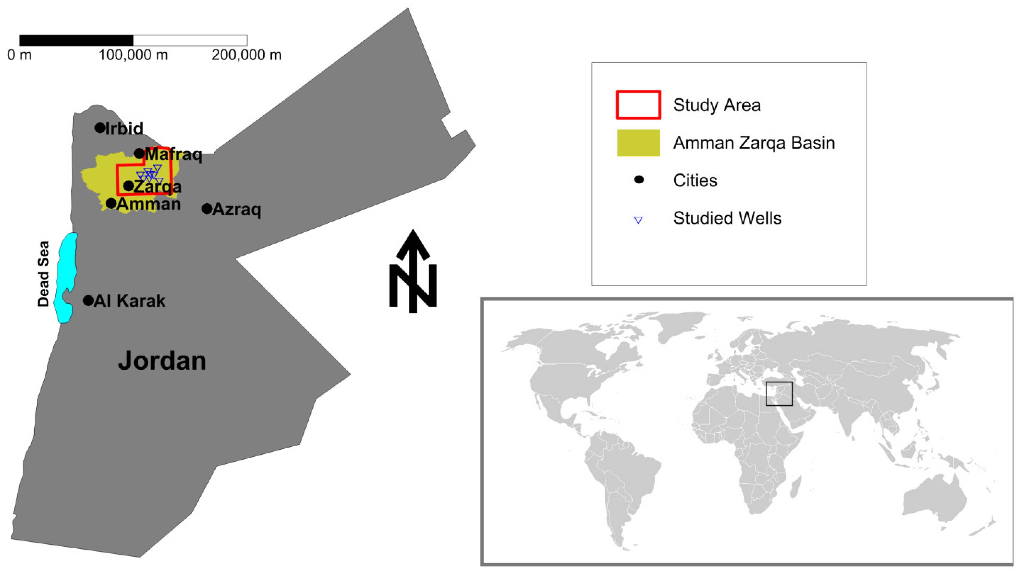
1.1. Study Area

1.2. Water Availability
2. Methods and Data
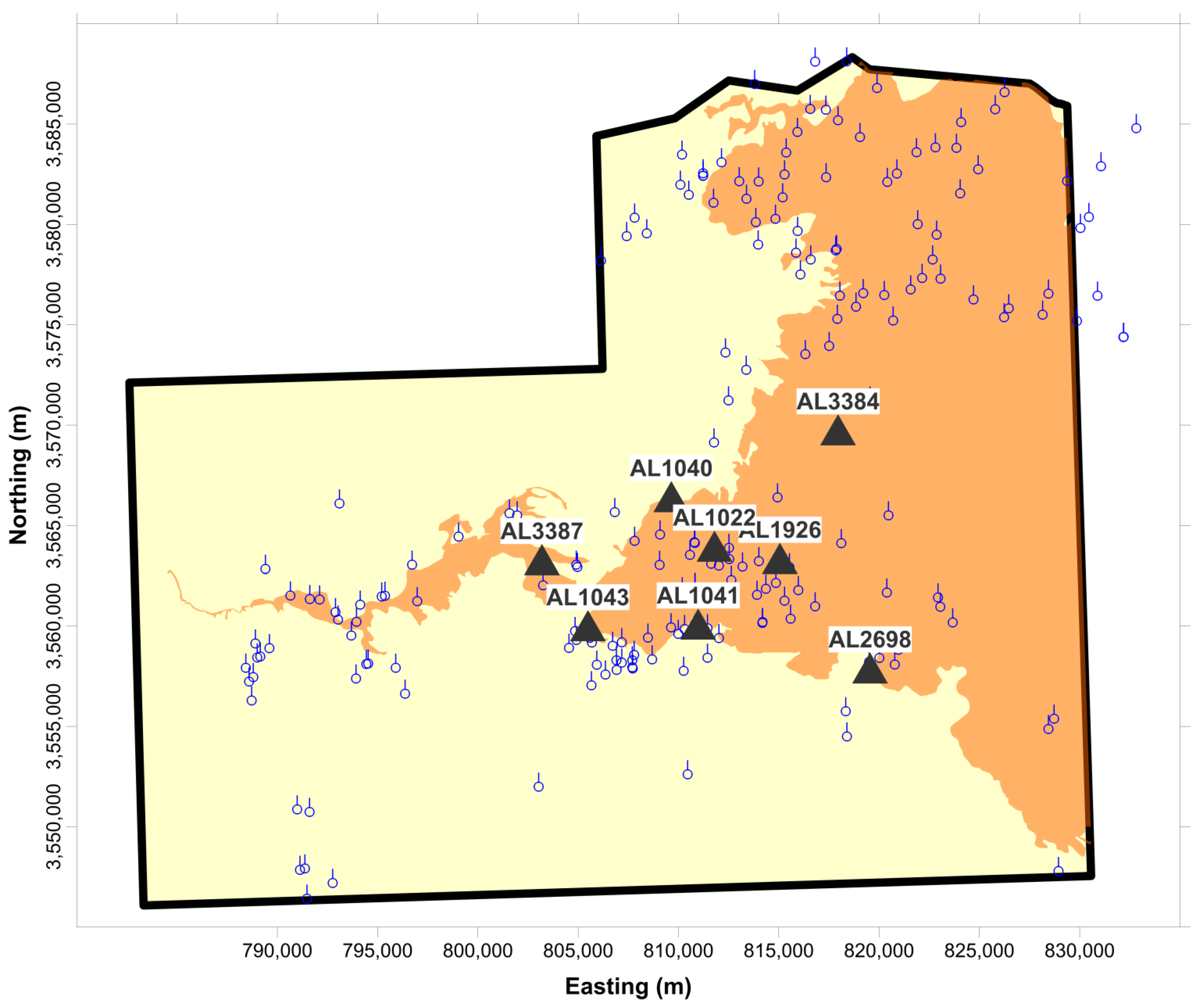
2.1. Well Data

| Well Name | Total Cumulative Drawdown (m) | Well Observation Period | Total Time (a) | Mean Annual Drawdown from 2000 Till 2015 (m) |
|---|---|---|---|---|
| AL 1043 | 31.11 | 01/2000–03/2015 | 15.17 | 2.05 |
| AL 1926 | 28.09 | 01/2000–02/2015 | 15.10 | 1.86 |
| AL 2698 | 18.25 | 01/2000–02/2015 | 15.10 | 1.21 |
| AL 3384 | 14.28 | 01/2000–02/2015 | 15.10 | 0.95 |
| AL 1022 | 10.98 | 03/2000–01/2014 | 13.83 | 0.79 |
| AL 3387 | 10.75 | 06/2001–03/2015 | 13.80 | 0.78 |
| AL 1041 | 59.79 | 01/2000–01/2013 | 13.00 | 4.60 |
| AL 1040 | 11.33 | 01/2000–05/2013 | 13.30 | 0.85 |
2.2. Remote Sensing
3. Study Results
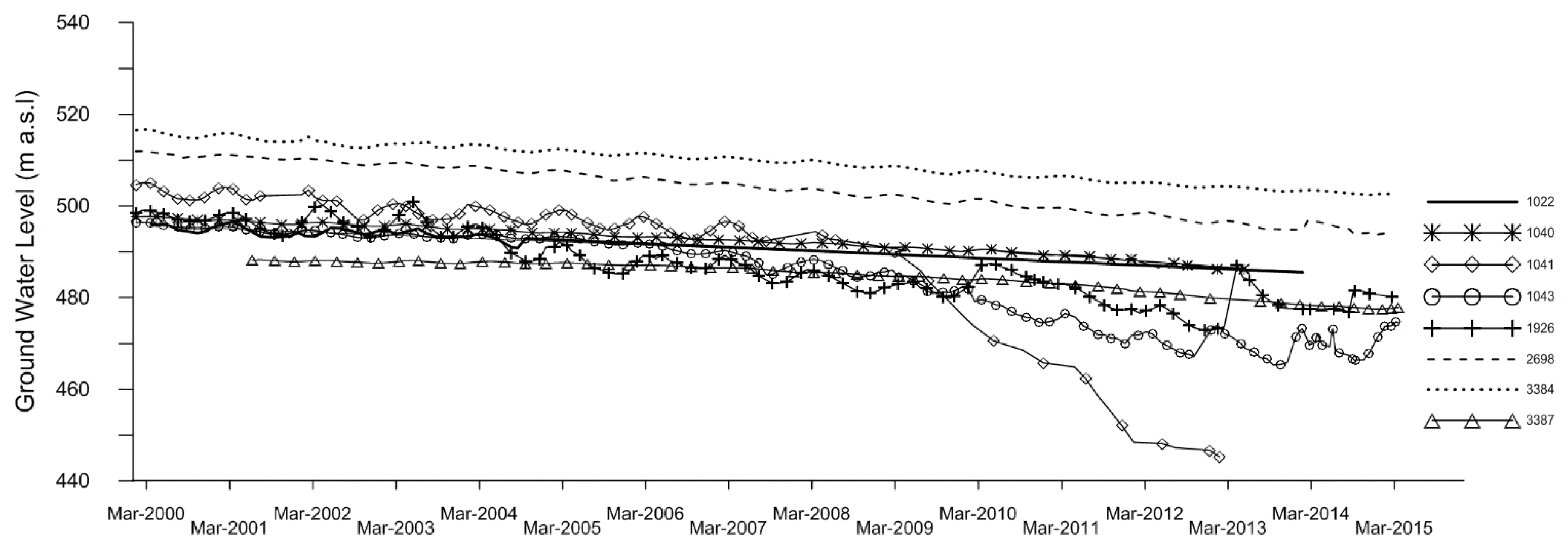
3.1. Well Data

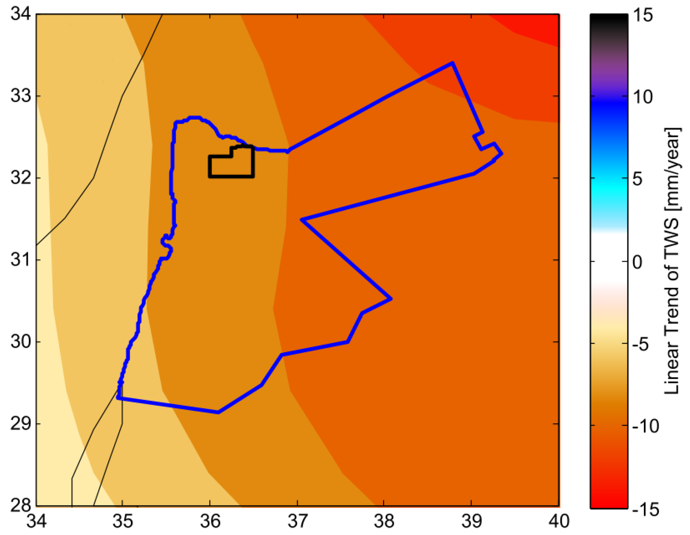
3.2. Remote Sensing

4. Discussion
5. Conclusions
Acknowledgments
Author Contributions
Conflicts of Interest
References
- Ta’any, R.; Tahboub, A.; Saffarini, G. Geostatistical analysis of spatiotemporal variability of groundwater level fluctuations in Amman Zarqa basin, Jordan: A case study. Environ. Geol. 2009, 57, 525–535. [Google Scholar] [CrossRef]
- DOS Jordan Department of Statistics 2010. Available online: http://www.dos.gov.jo/sdb_pop/sdb_pop_e/ehsaat/alsokan/2010/2-2.pdf (accessed on 3 November 2015).
- Al-Abed, N.; Al-Sharif, M. Hydrological modeling of Zarqa River Basin—Jordan using the hydrological simulation program—FORTRAN (HSPF) model. Water Resour. Manag. 2008, 22, 1203–1220. [Google Scholar] [CrossRef]
- Al-Bakri, J.T.; Salahat, M.; Suleiman, A.; Suifan, M.; Hamdan, M.R.; Khresat, S.; Kandakji, T. Impact of climate and land use changes on water and food security in Jordan: Implications for transcending “the tragedy of the commons”. Sustainability 2013, 5, 724–748. [Google Scholar] [CrossRef]
- UN-ESCWA and BGR (United Nations Economic and Social Commission for Western Asia; Bundesanstalt für Geowissenschaften und Rohstoffe); Inventory of Shared Water Resources in Western Asia: Beirut, Lebanon, 2013.
- Al Mahamid, J. Integration of water resources of the upper aquifer in Amman—Zarqa basin based on mathematical modeling and GIS, Jordan, Freiberg Online Geology, Germany, 2005. Available online: http://citeseerx.ist.psu.edu/viewdoc/download?doi=10.1.1.225.991&rep=rep1&type=pdf (accessed on 6 August 2015).
- Sidiropoulos, P.; Mylopoulos, N.; Loukas, A. Optimal management of an overexploited aquifer under climate change: The Lake Karla case. J. Water Resour. Manag. 2013, 27, 1635–1649. [Google Scholar] [CrossRef]
- Al-Weshah, R. Jordan’s water resources: Technical perspective. Water Int. 1992, 17, 124–132. [Google Scholar] [CrossRef]
- Rahman, K.S.M.; Gorelick, P.J.; Dennedy-Frank, J.; Yoon, B. Rajaratnam, declining rainfall and regional variability changes in Jordan. Water Resour. Res. 2015, 51. [Google Scholar] [CrossRef]
- Jordan Meteorological Department. Department Data Base; JMD: Amman, Jordan, 2015.
- Al-Kharabsheh, A.; Al-Mahamid, J. Optimizing pumping rates of Hallabat-Khalidiya Wellfield using finite-difference model: A case study for evaluating over pumped aquifers in arid areas (Jordan). J. Arid Environ. 2002, 52, 259–267. [Google Scholar] [CrossRef]
- Rimawi, O.; Al-Ansari, N. Groundwater degradation in the northeastern part of Mafraq area, Jordan. In Freshwater Contamination, Proceedings of Rabat Symposium S4, April–May 1997; IAHS Publ.: Oxfordshire, UK; pp. 235–243.
- Salameh, E. Over-exploitation of groundwater resources and their environmental and socio-economic implications: The case of Jordan. Water Int. 2008, 33, 55–68. [Google Scholar] [CrossRef]
- El-Naqa, A.; Al-Momani, M.; Kilani, S.; Hammouri, N. Groundwater deterioration of shallow groundwater aquifers due to overexploitation in northeast Jordan. Clean Soil Air Water 2007, 35, 156–166. [Google Scholar] [CrossRef]
- Bajjali, W.; Al-Hadidi, K.; Ismail, M. Water quality and geochemistry evaluation of groundwater upstream and downstream of the Khirbet Al-Samra wastewater treatment plant/Jordan. J. Appl. Water Sci. 2015. [Google Scholar] [CrossRef]
- Outline Hydrogeology of the Amman—Zarqa Basin, Report: Water Resources Policy Support; MWI Ministry of Water and Irrigation: Amman, Jordan, 2000.
- Margane, A.; Hobler, M.; al Momani, M.; Subah, A. Contributions to the Hydrogeology of Northern and Central Jordan—Geologisches Jahrbuch C 68; Schweizerbart Science Publishers: Stuttgart, Germany, 2002; p. 52. [Google Scholar]
- Becker, M.W. Potential for satellite remote sensing of ground water. Ground Water 2006, 44, 306–318. [Google Scholar] [CrossRef] [PubMed]
- MWI Files and Personal Communications; MWI Ministry of Water and Irrigation: Amman, Jordan, 2010.
- Richey, A.S.; Thomas, B.F.; Lo, M.-H.; Reager, J.T.; Famiglietti, J.S.; Voss, K.; Swenson, S.; Rodell, M. Quantifying renewable groundwater stress with GRACE. Water Resour. Res. 2015, 51, 5217–5238. [Google Scholar] [CrossRef]
- Longuevergne, L.; Wilson, C.R.; Scanlon, B.R.; Crétaux, J.-F. GRACE water storage estimates for the Middle East and other regions with significant reservoir and lake storage. Hydrol. Earth Syst. Sci. Discuss. 2012, 9, 11131–11159. [Google Scholar] [CrossRef]
- Voss, K.A.; Famiglietti, J.S.; Lo, M.-H.; de Linage, C.; Rodell, M.; Swenson, S.C. Groundwater depletion in the Middle East from GRACE with implications for transboundary water management in the Tigris-Euphrates-Western Iran region. Water Resour. Res. 2013, 49. [Google Scholar] [CrossRef] [PubMed]
- Forootan, E.; Rietbroek, R.; Kusche, J.; Sharifi, M.A.; Awange, J.; Schmidt, M.; Omondi, P.; Famiglietti, J. Separation of large scale water storage patterns over Iran using GRACE, altimetry and hydrological data. Remote Sens. Environ. 2014, 140, 580–595. [Google Scholar] [CrossRef]
- Wahr, J.; Molenaar, M.; Bryan, F. Time variability of the Earth’s gravity field: Hydrological and oceanic effects and their possible detection using GRACE. J. Geophys. Res. 1998, 103, 30205–30229. [Google Scholar] [CrossRef]
- Jet Propulsion Laboratory, Geocenter-Degree 1. Available online: http://grace.jpl.nasa.gov/data/get-data/geocenter/ (accessed on 26 September 2015).
- Jet Propulsion Laboratory, Spherical Harmonic coefficients of Degree 2. Available online: http://grace.jpl.nasa.gov/data/get-data/oblateness/ (accessed on 26 September 2015).
- Kusche, J.; Schmidt, R.; Petrovic, S.; Rietbroek, R. Decorrelated GRACE time-variable gravity solutions by GFZ, and their validation using a hydrological model. J. Geod. 2009, 83, 903–913. [Google Scholar] [CrossRef]
- Rodell, M.; Houser, P.R.; Jambor, U.; Gottschalck, J.; Mitchell, K.; Meng, K.; Arsenault, K.; Cosgrove, B.; Radakovich, J.; Bosilovich, M.; et al. The global land data assimilation system. Bull. Am. Meteorol. Soc. 2004, 85, 381–394. [Google Scholar] [CrossRef]
- Forootan, E.; Kusche, J. Separation of global time-variable gravity signals into maximally independent components. J. Geod. 2012, 86, 477–497. [Google Scholar] [CrossRef]
- Longuevergne, L.; Scanlon, B.R.; Wilson, C.R. GRACE hydrological estimates for small basins: Evaluating processing approaches on the High Plains Aquifer, USA. Water Resour. Res. 2010, 46. [Google Scholar] [CrossRef]
- Goode, D.J.; Senior, L.A.; Subah, A.; Jaber, A. Groundwater-Level Trends and Forecasts, and Salinity Trends, in the Azraq, Dead Sea, Hammad, Jordan Side Valleys, Yarmouk, and Zarqa Groundwater Basins, Jordan; Open-File Report 2013–1061; U.S. Department of the Interior: Washington, DC, USA; U.S. Geological Survey: Reston, VA, USA, 2013.
- Abu Sharar, R. Water chemistry of the Dhuleil aquifer (Jordan) as influenced by long term pumping. J. Hydrol. 1993, 149, 49–66. [Google Scholar] [CrossRef]
- Bajjali, W.; Al-Hadidi, K. Recharge origin, overexploitation, and sustainability of water resources in an arid area from the Azraq basin, Jordan: Case study. Hydrol. Res. 2006, 37, 277–292. [Google Scholar] [CrossRef]
- Swenson, S.; Wahr, J.; Milly, P. Estimated accuracies of regional water storage variations inferred from the Gravity Recovery and Climate Experiment (GRACE). Water Resour. Res. 2003, 39. [Google Scholar] [CrossRef]
- MWI Ministry of Water and Irrigation Web Site, Jordan Water Sector Facts and Figures 2013. 2014. Available online: http://www.mwi.gov.jo/sites/en-us/Documents/W.%20in%20Fig.E%20FINAL%20E.pdf (accessed on 6 August 2015).
- Amelung, F.; Galloway, D.L.; Bell, J.W.; Zebker, H.A.; Laczniak, R.J. Sensing the ups and downs of Las Vegas: In SAR reveals structural control of land subsidence and aquifer-system deformation. Geology 1999, 27, 483–486. [Google Scholar] [CrossRef]
- Abidin, H.Z.; Andreas, H.; Gamal, M.; Wirakusumah, A.D.; Darmawan, D.; Deguchi, T.; Maruyama, Y. Land subsidence characteristics of the Bandung Basin, Indonesia, as estimated from GPS and InSAR. J. Appl. Geod. 2008, 2, 167–177. [Google Scholar] [CrossRef]
© 2015 by the authors; licensee MDPI, Basel, Switzerland. This article is an open access article distributed under the terms and conditions of the Creative Commons Attribution license (http://creativecommons.org/licenses/by/4.0/).
Share and Cite
Al-Zyoud, S.; Rühaak, W.; Forootan, E.; Sass, I. Over Exploitation of Groundwater in the Centre of Amman Zarqa Basin—Jordan: Evaluation of Well Data and GRACE Satellite Observations. Resources 2015, 4, 819-830. https://doi.org/10.3390/resources4040819
Al-Zyoud S, Rühaak W, Forootan E, Sass I. Over Exploitation of Groundwater in the Centre of Amman Zarqa Basin—Jordan: Evaluation of Well Data and GRACE Satellite Observations. Resources. 2015; 4(4):819-830. https://doi.org/10.3390/resources4040819
Chicago/Turabian StyleAl-Zyoud, Sana’a, Wolfram Rühaak, Ehsan Forootan, and Ingo Sass. 2015. "Over Exploitation of Groundwater in the Centre of Amman Zarqa Basin—Jordan: Evaluation of Well Data and GRACE Satellite Observations" Resources 4, no. 4: 819-830. https://doi.org/10.3390/resources4040819
APA StyleAl-Zyoud, S., Rühaak, W., Forootan, E., & Sass, I. (2015). Over Exploitation of Groundwater in the Centre of Amman Zarqa Basin—Jordan: Evaluation of Well Data and GRACE Satellite Observations. Resources, 4(4), 819-830. https://doi.org/10.3390/resources4040819