1. Introduction
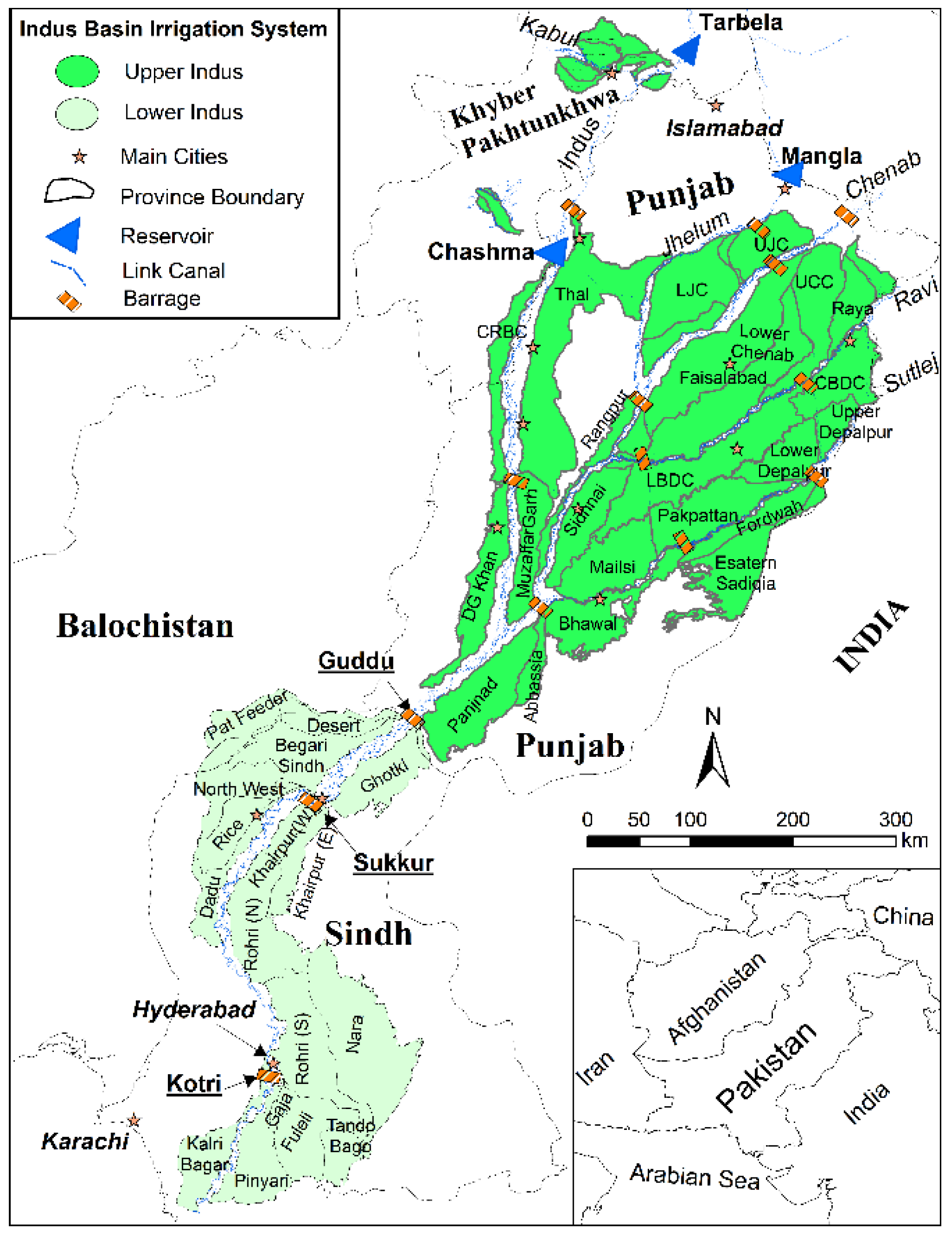
The Indus Basin Irrigation System (IBIS) is described as the world’s single largest “mega” irrigation system—covering a total area of 17.2 Mha. The IBIS consists of The Indus River, itself falling ultimately to Arabian Sea, and the tributaries Kabul, Jhelum, Chenab, Ravi, Beas and Sutlej. However, for the latter three rivers, India has full rights under the Indus Water Treaty (IWT) of 1960. Furthermore, for river water storage and diversion, the IBIS comprises three major reservoirs, 16 barrages, two head-works, two siphons across major rivers, 12 inter river link canals, and 44 canal irrigation systems (normally called canal commands), of which 23 are in Punjab, 14 in Sindh, five in Khyber Pakhtunkhwa (KP), and two in Baluchistan (
Figure 1).
Figure 1.
Indus Basin Irrigation System (IBIS), including rivers, link canals, barrages and canal commands.
Figure 1.
Indus Basin Irrigation System (IBIS), including rivers, link canals, barrages and canal commands.
With increased supplies from Mangla and Tarbela reservoirs, agricultural water supply has improved greatly, but, at the same time, this has contributed towards increased recharge of the groundwater. This increased recharge was utilized for supplementing crop water requirements in Punjab. However, in Lower Indus, the groundwater has not been developed in comparison to this increasing rate of groundwater recharge. This changing water balance has caused permanently waterlogged conditions, especially during and immediately after the Kharif season, with the result of low cropping intensities and obviously lower crop yields than the potential, especially in the Rabi season. Furthermore, while the water management approach being followed is heavily outdated, the population has increased over time. The people in Thar are constantly facing food and water shortages. The drought of 1999–2002 presented the best demonstration for the Indus system, especially the Lower Indus, in the form of reduced waterlogging without any reduction in crop yields [
1].
At present, the water management is still based on per/post-independence historic allocations, without any logic to justify over or under allocations amongst different areas, with persistent and heavily waterlogged areas in many of the canal commands in the Lower Indus part of the IBIS [
2,
3]. Similarly, a World Bank paper [
4] pointed out that “the realistic water requirements of the canals are required to be re-calculated, keeping in view of various factors under the present situation”. This means that water allowances are, therefore, required to be revised accordingly [
5]. Also, it has been projected that urban water requirement for the 25 major cities of Pakistan would be 6.34 and 8.67 BCM, respectively, for the years 2030 and 2050, against the current supply of about 4.0 BCM [
6]. Therefore, the current situation of increasing water demands, calls for integration of water demand and supply across and within all the water use sectors. In this context, this paper demonstrates for the Lower Indus that the groundwater has considerably higher potential that it is largely unexplored, due to ample availability of canal water and, in several areas, the high salt content.
2. Study Area
Sindh Province forms the southern part of the Indus Plain that lies below Guddu, forming the narrowest width of the Indus Plain below the confluence of the Punjnad River with the Indus (
Figure 1). The climate of Sindh is hot and arid, and the maximum temperature in summer exceeds 40 °C. Evaporation in Sindh is higher than anywhere else in Pakistan. Mean annual precipitation ranges from about 100 to 200 mm in parts of the Lower Indus Plain, whereas lake evaporation stands at 2800 mm at Thatta [
7]. The Indus enters Sindh province at an elevation of 75 m (246 ft) above mean sea level (amsl). Gradients are very flat in the area and have an average rate of 12.5 cm/km (eight inches/mile). The river lies on a slight ridge, which slopes away in lateral direction up to Larkana. Thus, it has an influent behavior and loses water to the underlying aquifer. Some of the flow drains towards the desert in the east. Another part flows towards the Khirthar Hills. In the Rabi season, when the flow in the river below Sukkur Barrage is almost zero, the river receives groundwater, especially from the left bank.
The Indus River provides irrigation to a major portion of Sindh (about 41 percent) through the canals taking off from the three Barrages in Sindh: Guddu, Sukkur and Kotri. A very small part of Balochistan Province is also irrigated through the Pat Feeder Canal from Guddu Barrage and the Kirthar Branch from North West Canal, taking off from Sukkur Barrage. The total Gross Command Area (GCA) of the Lower Indus plain (Sindh and Baluchistan,
Figure 1) is 5.92 Mha with a culturable command area (CCA) of 5.43 Mha. The major crops in the area are wheat, cotton, rice, and sugarcane, which utilize 68 percent of the total cropped area. Sindh also produces horticultural crops: mangoes, bananas, dates and chilies. Sindh has a diversion capacity of 111 Billion Cubic Meter (BCM), which is equivalent to 90 Million Acre Feet (MAF); but, as per the Water Accord 1991, Sindh’s share is 60.15 BCM (48.76 MAF) of surface water. In addition, annual groundwater use is about 4.3 BCM [
8], but it is unregulated and unplanned.
Groundwater Use in Lower Indus Plain—A Contrast to Upper Indus
Compared to the situation in the Upper Indus, groundwater use in the Lower Indus is very modest; yet waterlogging (groundwater within 1.5 meter of the soil surface) is common and has been assessed to prevail over 1.5 to 3.5 Mha. While in Punjab groundwater use at field scale is equivalent to canal water use in various canal commands [
9,
10], in Sindh this is not the case. For example, for the Lower Bari Doab Canal, based on the 2005 tube well survey data, total groundwater abstraction was estimated as 4674 MCM (million cubic meter) [
11]. On the basis of the same data, the Halcrow [
12] consultants for LBDC (Lower Bari Doab Canal) calculated the revised estimates of groundwater abstraction for the year 2005 as 4796 MCM, against annual average canal supplies of 4849 MCM (3.93 MAF) diverted to the LBDC at its head [
9]. Thus, canal and ground water use in the LBDC irrigation system are at par with each other. In addition, there is no waterlogging in the command, which means that whatever is recharged to the aquifer from the irrigation and rainfall is again pumped for meeting deficit supplies from the irrigation system.
In Punjab, the number of tube wells was 944,649 in 2009–2010 [
13], and is now over 1,000,000. This growth in the number of tube wells has made higher crop intensity and precision farming possible. In comparison, the estimated number of tube wells in Sindh was 95,921 in 2010–2011 [
14]. This includes a small number of public fresh water drainage tube wells. Out of 4100 of such so-called “SCARP (Salinity Control and Reclamation Project)” tube wells installed since the mid-1960s, less than 10% are operational—often under
de facto joint farmer management. Tube well densities in different canal commands are in the order of two to three private tube wells per 100 ha [
15,
16]. However, in the command areas of the canals that start from Guddu Barrage (Begari, Ghotki and Desert), wells are virtually non-existent, with the exception of the tail reaches and the higher lands, even though the shallow groundwater in many areas is fresh.
A look into how things could be if surface water supplies were not overabundant can be seen in the groundwater exploitation in the Kunner—2 Minor (near Hyderabad), where tube well density is 6.6 per 100 hectares—related to relatively better groundwater qualities and the proximity to a major market. Another example is the higher lands in Pano Aqil in the Ghotki command areas, where canal supplies are inadequate and tube well densities exceed 15 per 100 ha. In general, even in some fresh groundwater zones, tube well densities are low and there is also evidence of fresh SCARP tube well water being routed directly to disposal canals and not being used in agriculture. Low tube well densities are also seen in saline zones; hardly any tube wells are present there. However, in comparable saline groundwater areas in Punjab, the number of tube wells is considerably higher. The basic reason is that the water allowance in Punjab varies from 2.73 to 4.2 cusec/1000 acres, whereas in Sindh the water allowance ranges from 8 to 17 cusecs/1000 acres. Thus, farmers are forced to supplement their deficit canal supplies with groundwater pumping.
The most recent assessment of overall groundwater abstraction in Sindh was 4.3 BCM [
8]. Another study from the same period by the IWMI (International Water Management Institute) estimated the discharge through tube wells to be even lower,
i.e., at 2.15 BCM (about 2 MAF) [
17]. In other words, groundwater use stands at about 4%–8% of surface water use in Sindh, whereas in the canal areas of Punjab, the use of surface and groundwater at farm level are approximately 50:50 [
10]. These figures may need to be updated, but in general, groundwater is an underutilized resource in the canal-irrigated areas of Sindh. A large part of the groundwater use in Sindh is in the riverine areas where there are no irrigation canals and the soils are relatively sandy. In contrast, there is relatively limited use of groundwater in the canal command areas due to the high surface water allocations.
In addition, because of widespread waterlogging, water productivity in Sindh is also considerably less than Punjab. For the different canal commands in Sindh, it ranges between 0.32 and 1.15 kg per m
3 for wheat, whereas in Punjab, the median is 1.08 kg per m
3. In the Indian Punjab, it is 1.42 kg per m
3, being again 35% higher than in Pakistani Punjab [
18]. Variations in water productivity in different command areas under the Sindh Irrigation System as well as overall productivity are shown in
Table 1.
Table 1.
Overall water productivity (WP) in various canal commands in Sindh [
18].
Table 1.
Overall water productivity (WP) in various canal commands in Sindh [18].
| AWB/Command Area | Eta (mm) | BIO (kg/ha) | WP (kg/m3) |
|---|
| Khairpur West | 1281 | 14,820 | 1.15 |
| Rice | 1225 | 12,380 | 1 |
| Rohri | 1203 | 12,153 | 0.98 |
| Ghotki | 1083 | 10,622 | 0.96 |
| Khairpur East | 1105 | 10,530 | 0.9 |
| Pat Feeder | 1004 | 8437 | 0.8 |
| Begari | 1148 | 8359 | 0.71 |
| Desert | 1152 | 8303 | 0.7 |
| Dadu | 1042 | 7657 | 0.69 |
| Northwest | 1130 | 7961 | 0.68 |
| Nara | 1098 | 7009 | 0.61 |
| Gaja Branch (Old Fuleli) | 1371 | 7760 | 0.55 |
| Fuleli | 1287 | 5791 | 0.44 |
| Lined (TandoBago) | 1304 | 5437 | 0.41 |
| Pinyari | 1277 | 5178 | 0.39 |
| Kalri | 1228 | 4192 | 0.32 |
3. Data Sources and Methods
Managing surface irrigation in an extensive system such as that in Sindh, with extremely long canals, a flat gradient, pre-dominant saline groundwater and widespread alkaline and saline soils is a huge and daunting challenge, to say the least, and in the management of the canal system in Sindh some things have not gone well. This is because water management on a scientific basis has never been evaluated for the Lower Indus area. Here, we analyzed the situation with an extensive and comprehensive literature review and data analysis regarding different water management challenges, i.e., groundwater quality, drainage facilities and their requirements, irrigation water supplies, the resulting waterlogging and surface salinity conditions, and their impact on crop yields on temporal and spatial scales. Based on this comprehensive insight of the issues being faced in the area, we recommend a set of integrated approaches that can offer a comprehensive and long-term solution for conjunctive water management and also result in consequent increased crop output from the area.
4. Water Management Challenges Being Faced in Lower Indus
The amount of annually renewable groundwater available in Sindh is estimated to be 22 to 27 BCM (18 to 22 MAF); yet only a fraction of this is used—with the groundwater discharge now leading to waterlogging and soil salinity. There is a need to make better use of groundwater in Sindh. One of the reasons for this concerns the challenge of climate change: with more extreme hydrological situations, the buffering role of groundwater becomes important. Another reason is the expected reduced availability of surface water due to sedimentation of the current large storage reservoirs. Over the years, three main water reservoirs in Pakistan have been constructed, Tarbela, Mangla and Chashma, with a total live storage of 20 BCM (16.29 MAF). However, as a result of sedimentation, the effective gross capacity of these reservoirs has been reduced by 5.4 BCM (4.37 MAF) (28%) as of 2012 [
19]. Moreover, it is expected that the process of sedimentation will continue and gross surface storage loss would reach 7.18 BCM (5.82 MAF) (37%) by 2025 [
20]. This calls for better management of groundwater reservoirs.
At present, the groundwater buffer is not well managed, with waterlogging being the main manifestation. This suppresses farm yields and keeps cropping intensity relatively low. In Sindh, these cropping intensities have increased significantly over the original intensities. They are, however, considerably lower than they are in Punjab, varying from 116.7% in Sindh Cotton Wheat zone (SCWS) to 234.0% in Punjab Sugarcane Wheat zone (PSW) [
21]. The impacts are not only limited to agriculture but also extend beyond. Thus, the area is facing multifaceted water management challenges that are interlinked and acting in combination to produce various ill effects regarding water management and the ensuing crop and soil environment. These water management challenges are discussed in detail as follows.
4.1. Groundwater Salinity
Groundwater salinity in Sindh is widespread. In 1959, a program of investigations was started by Water and Power Development Authority (WAPDA) by the name of Lower Indus Project (LIP). Bore holes, varying from 30 to 90 m deep, were drilled in the Guddu, Sukkur and Kotri Barrage commands, to determine aquifer characteristics and the quality of groundwater in horizontal and vertical scales [
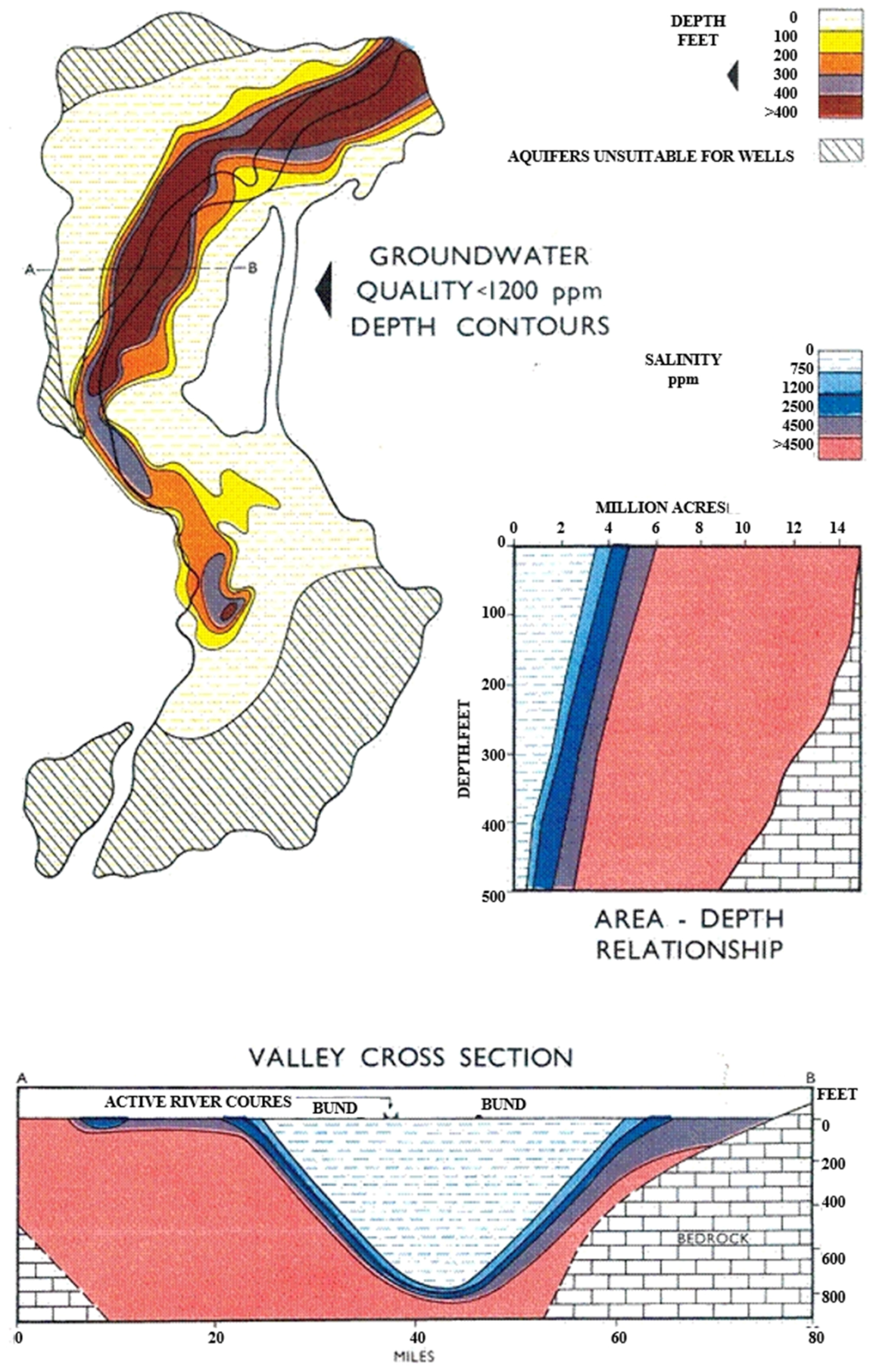
22]. The general pattern of groundwater distribution in the Lower Indus Plains is one of good quality water immediately adjacent to the river, with increasing salinity as we move away from the river (
Figure 2). A lesser quantity of good quality water is available on the right bank of the river than on the left [
23]. This is due to the proximity of limestone hills on the right bank as well as the poor aquifers associated with piedmont plains. Another feature of importance is the complete absence of usable groundwater in the deltaic area south of Hyderabad, with the exception of some shallow pockets in the recently abandoned riverbeds of the Gaja Command.
Throughout the region, the salinity of groundwater increases with depth and no case has been recorded in Sindh where saline water overlies fresh water. Based on the assessments of LIP, it is estimated that 71% of Sindh's irrigated area has groundwater that is too saline (>1500 ppm) for irrigation [
24]. However, the picture improves if one looks at shallower depths (<15 m), where salinity is less widespread. According to Ahmad [
23], there are many sites where shallow useable groundwater exists. The total fresh groundwater zones at shallow depth (15 m) are tentatively estimated as spreading over 46% of the area [
3]. However, further detailed groundwater investigations are needed for precise assessment of different groundwater qualities at shallow depths.
Figure 2.
Vertical and horizontal extent of groundwater salinity in Lower Indus (Developed from [
23]).
Figure 2.
Vertical and horizontal extent of groundwater salinity in Lower Indus (Developed from [
23]).
4.2. High Irrigation Supplies and Waterlogging
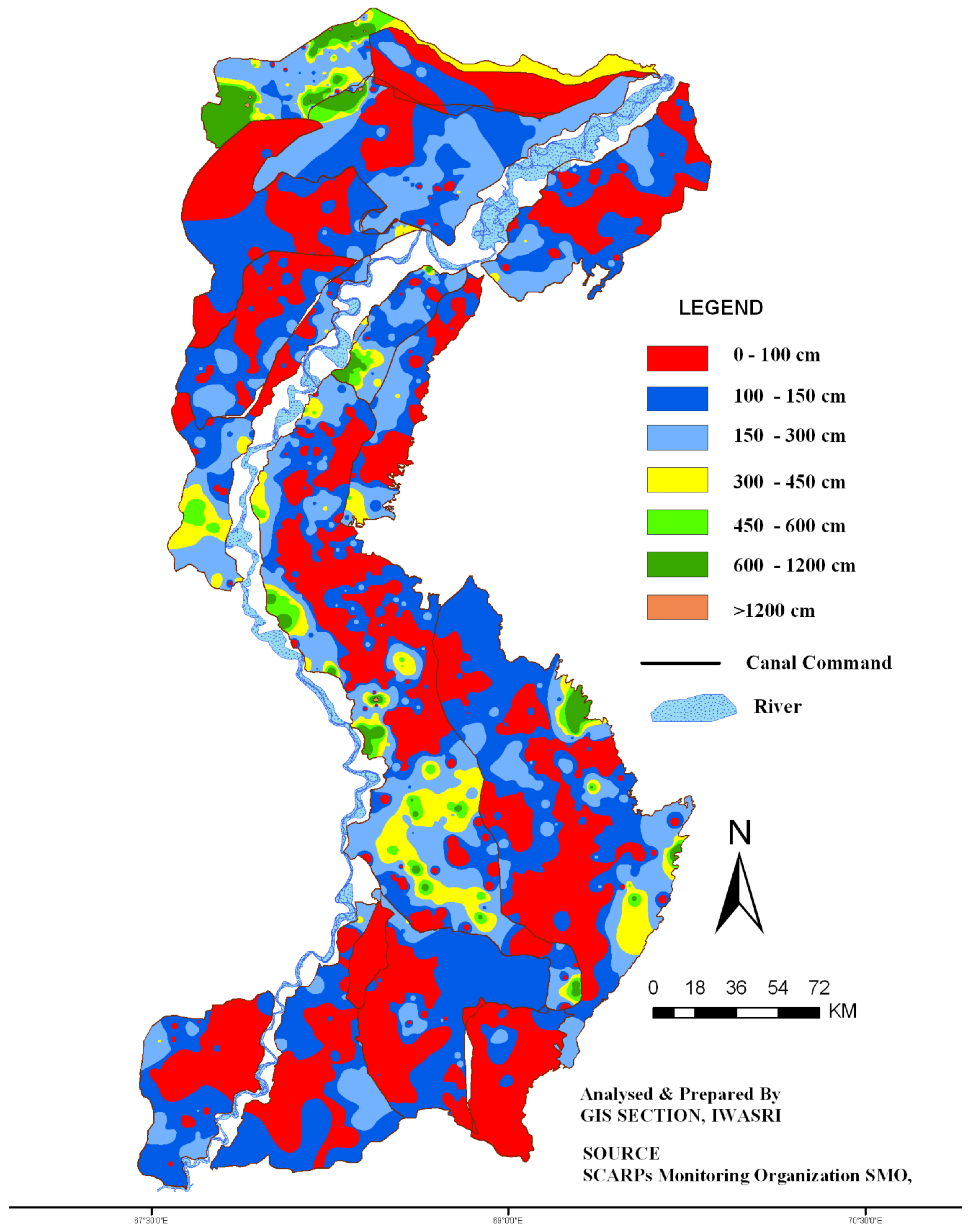
The most prominent element explaining the limited use of groundwater in Lower Indus is the high surface irrigation allowances in several of the canal commands in Sindh (8 to 17 cusecs per 1000 acres). The situation of high allowance is more amplified because in several canal commands, water is diverted in excess of the allowances. The picture is further distorted within the canal commands by unregulated direct outlets, tampered off-takes or in some areas, extensive canal seepage, creating local overabundance of water.
These high surface water deliveries have given rise to widespread waterlogging. In October 2011, for instance, 36% of the command area had a depth to water table of less than 1.0 m, and another 33.6%, a water table within the range of 1.0 to 1.5 m. Thus, in about 70% of the command area in the province, the root zone is waterlogged (
Figure 3). This means only about 30.4% area was not waterlogged during October 2011 [
3]. The extent of waterlogging conditions usually only drops off just before monsoon, due to less canal supplies during the Rabi season. In acreage, the affected area is colossal: 2.19 M ha in post monsoon 2011, with major impacts on the sowing of Rabi crops, especially wheat (
Figure 4).
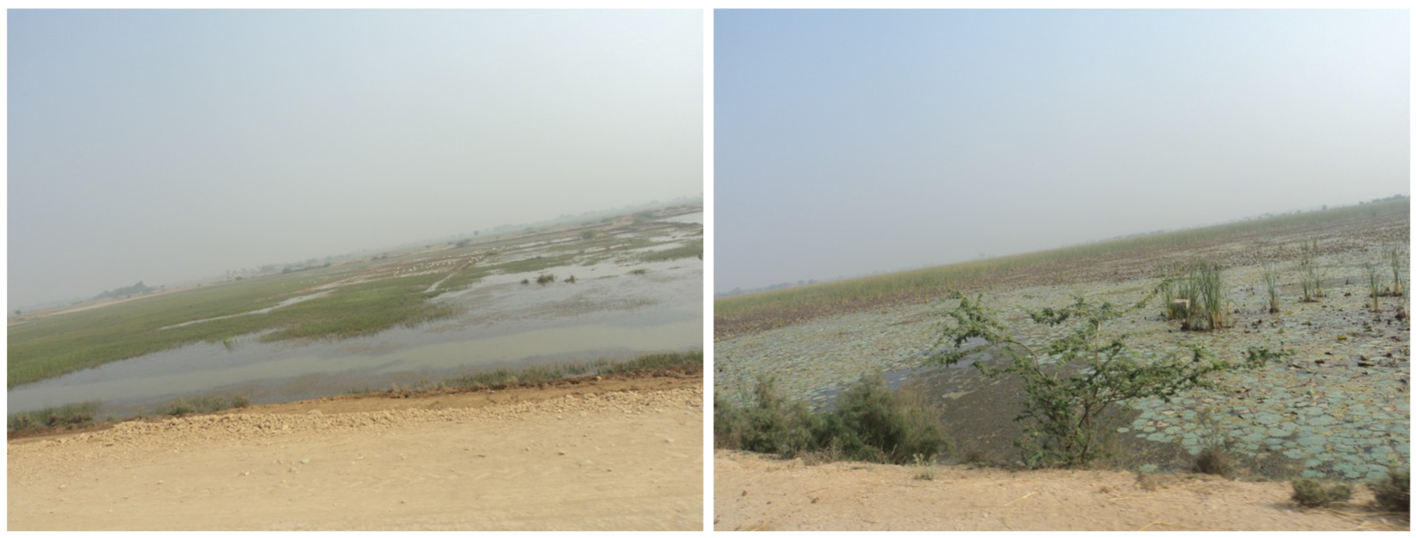
Figure 3.
Vast agricultural lands lying barren with ponded water in Rice Canal Command (13 December 2013).
Figure 3.
Vast agricultural lands lying barren with ponded water in Rice Canal Command (13 December 2013).
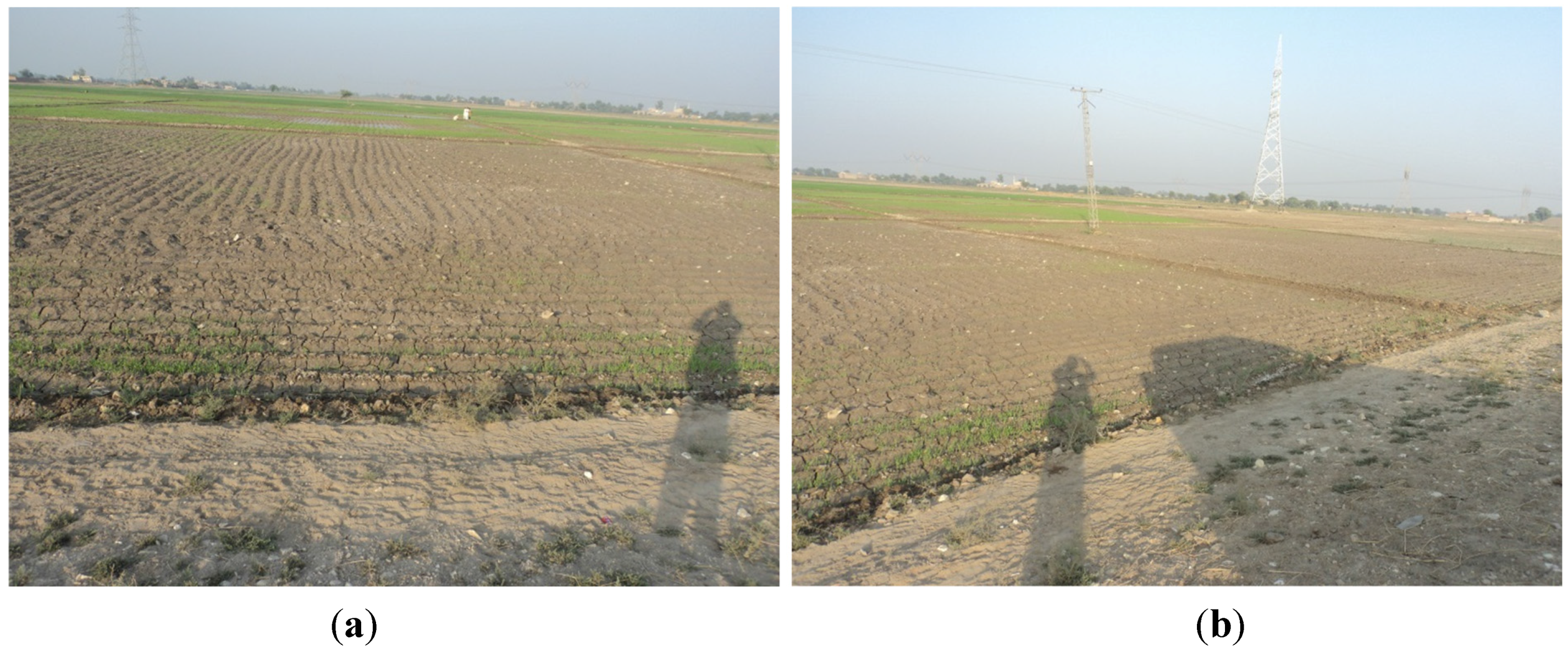
Figure 4.
Patchy wheat crop germination due to waterlogging and salinity in Mirpur Khas (a); and Dadu (b) districts (pictures taken on 11–12 December 2013).
Figure 4.
Patchy wheat crop germination due to waterlogging and salinity in Mirpur Khas (a); and Dadu (b) districts (pictures taken on 11–12 December 2013).
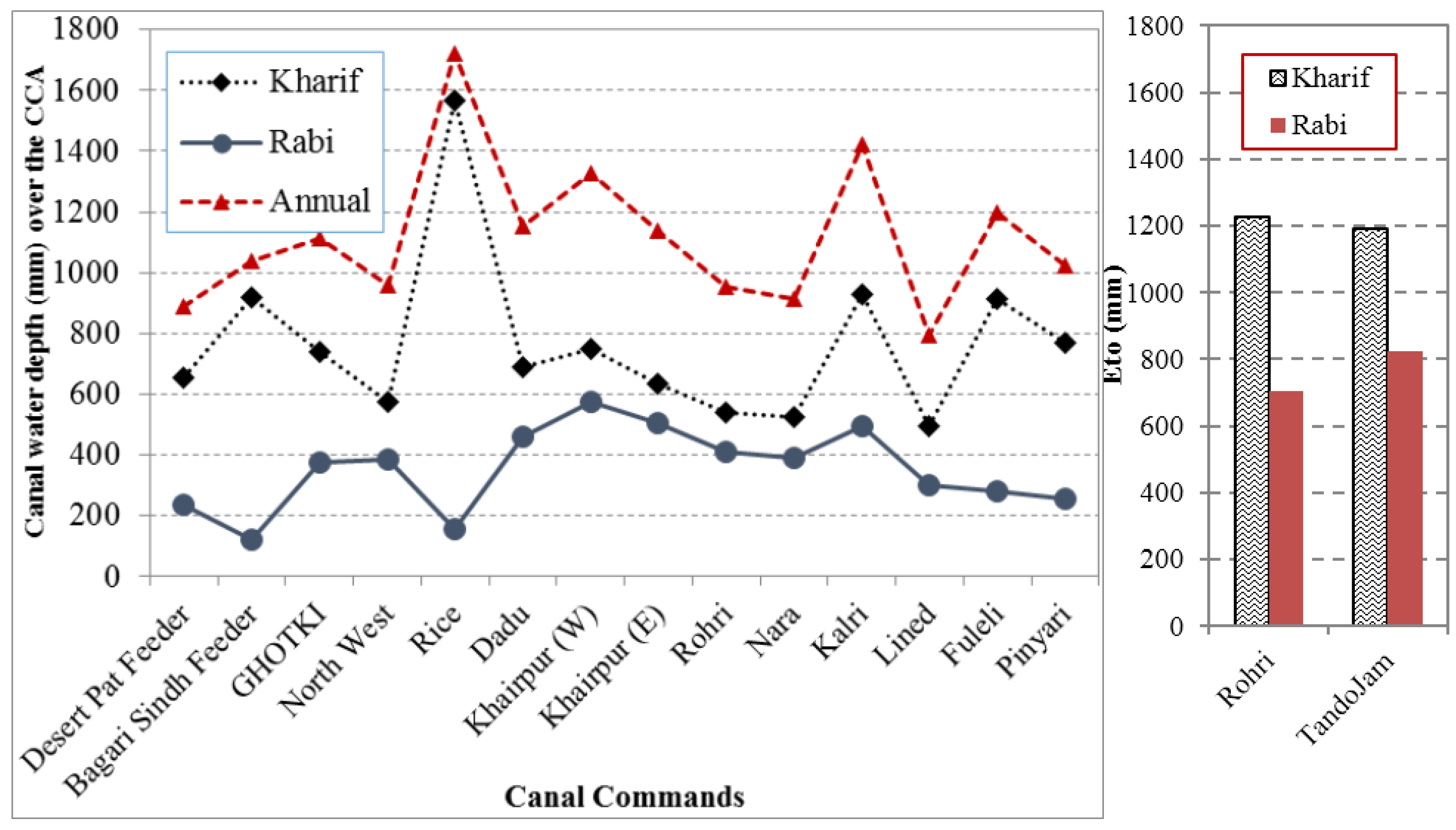
There is a wide variety of irrigation allocations in the canal systems in Sindh. These are not necessarily based on any water management logic, but on a series of historic decisions. Basharat
et al. [
3] analyzed canal water supplies per cultivable canal area for the different canal systems in Sindh and Balochistan. The depth of water (mm) over the CCA differs widely (
Figure 5). The Rice and Kalri command areas are entitled to the highest allowances. Annual average supplies to the Rice command is 1723 mm, almost close to the annual reference crop evapotranspiration in the area, and with an additional annual rainfall of about 200 mm.
Figure 5.
Comparison of canal water supplies amongst the irrigation systems in Lower Indus [
3].
Figure 5.
Comparison of canal water supplies amongst the irrigation systems in Lower Indus [
3].
An example of an area with larger surface water availability and a limited use of its fresh groundwater is the Jalbani Distributary, which takes-off from North West Canal and has a command area of 8642 acres [
1]. The irrigation duty for the Distributary is high—12.15 cfs/1000 acre (84 L/s/100 ha). The actual water delivery per acre is even higher, as not more than 50% of the command areas are used in any season, due to the rest being waterlogged. Even during the drought period of 1999 to 2002, surface water supplies—despite being reduced by 5% to 10%—remained abundant. There was more (though still limited) interest among farmers to compensate for the lower supplies by developing shallow wells. The drought helped to lower water tables, as observed from SMO (SCARP Monitoring Organization). In the observation wells, water table had deepened from 1 to 1.5 m deep in the normal years to 1.5 to 2 m in drought period (1999–2002). In several areas, this was beneficial for wheat cultivation in the Rabi season.
The overgenerous surface irrigation supplies, especially in some canal commands, reduce the need for additional groundwater irrigation [
25]. Several studies have also argued that in many areas of Northern Sindh, a layer of fresh water is present over the more saline water that could be exploited more extensively by skimming wells. Some small tube wells and dug wells already use these lenses along canals and distributaries in several parts of Sindh, where water is relatively short in supply (canal tail ends in the area with low surface irrigation supplies). In many areas, however, surface water supplies in the canals fed from Guddu Barrage are so high that there is little incentive to pump. In the post-monsoon period the entire area is waterlogged, as shown in
Figure 6 [
1]. Moreover, within the canal commands, there is no difference in water allowance for fresh and saline areas, which can encourage groundwater pumping.
Figure 6.
Depth to water table map of Lower Indus, post monsoon 2011 [
3].
Figure 6.
Depth to water table map of Lower Indus, post monsoon 2011 [
3].
Thus, the main cause for this extensive waterlogging and low cropping intensities is the high and generally outdated surface irrigation allocations. Waterlogging appears to be particularly persistent in the areas served by non-perennial canals. These canals receive copious supplies in the Kharif season, causing the water table to rise significantly, but to fall again in the winter season, when the canals are not flowing. Rice Canal in District Larkana Area is one of the main examples of this phenomenon, where the water table fluctuates between one and three meters during Kharif (summer) and Rabi (winter) seasons. This annual cycle of rise and fall of water table has brought the salts to the upper soil strata [
26]. By regulating the flow after the commissioning of the Tarbela and Mangla Dams, made 24% more water available for irrigation and some canals are now converted officially or unofficially to perennial canals. Canal duties were, however, not officially recalibrated after this additional water became available. The problems in the perennial channels in Sindh are different from those in the non-perennial channels. In the former, the water duties are generally lower (though still higher than elsewhere in the subcontinent). Here, salinity is concentrated in areas with deficient surface water supplies, as there is not enough water for leaching accumulated salts. This often concerns the tail reaches of the channels.
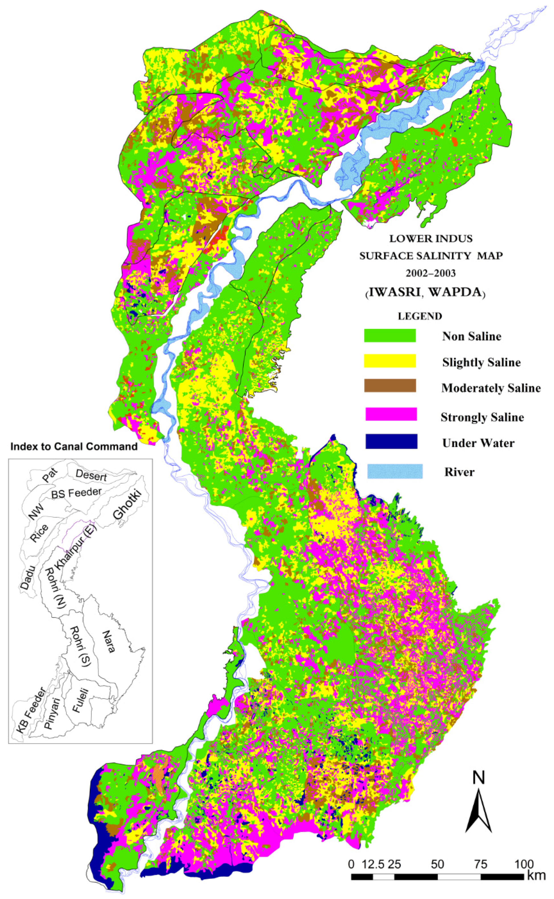
4.3. Surface Salinity
Closely linked to high water tables and widespread waterlogging, the Lower Indus also has extensive surface salinity. Such surface salinity is caused by capillary rise in areas with high water tables [
27], particularly common in areas with reduced dry season supplies or low irrigation supplies in general, or in lands surrounded by heavily waterlogged lands. Farmers respond by planting kalar grass or Sesbania, deep plowing, and adding press mud or organic manure.
Figure 7 gives an overview based on the latest available surface salinity survey (2002–2003) by IWASRI (International Waterlogging and Salinity Research Institute).
A comparison of the 2002–2003 survey for Sindh and Balochistan with the earlier main survey of 1976–1979 shows that soil salinity in the Lower Indus had increased from 46% to 51% (
Table 2). In the same period, the trend in the Upper Indus was opposite and surface salinity reduced from 14% to 7%. This was caused by the lowered ground water table in Punjab that was the result of intense use of shallow groundwater for irrigation purposes.
Table 2.
Trends in Surface Salinity in Lower Indus Irrigation Systems (Sindh and Balochistan).
Table 2.
Trends in Surface Salinity in Lower Indus Irrigation Systems (Sindh and Balochistan).
| Soil Class | ECe (dS/m) at 25 °C | Salt (%) | 1976–1979 (%) | 2001–2003 (%) |
|---|
| Non Saline | Less than 4 | Less than 0.2 | 54 | 49 |
| Slightly Saline | 4–8 | 0.2–0.5 | 19 | 46 | 20 | 51 |
| Moderately Saline | 8–15 | 0.5–1.0 | 10 | 10 |
| Strongly Saline | More than 15 | More than 1.0 | 17 | 21 |
Figure 7.
Soil surface salinity in Lower Indus [
3].
Figure 7.
Soil surface salinity in Lower Indus [
3].
4.4. L\ack of Field Drainage
In addition to higher canal supplies, there are other reasons for waterlogging too, e.g., almost 50% of the cultivable command area does not have drainage facilities. Although 18 different drainage projects consisting of surface and sub-surface drainage, covering an area of 2.3 Mha, were completed from 1963 to 1990s, afterwards no major attention was paid to their operation and maintenance (
Table 3). The present surface drainage density is usually not more than 3–7 m/ha. This leaves much of the land without a drainage system. Thus, root zone drainage is almost entirely ignored. The waterlogging is further aggravated because over the years main natural drains have been blocked by the private encroachment and construction of roads and other infrastructure.
Table 3.
Drainage facilities in Pakistan—up to June 2001 [
28].
Table 3.
Drainage facilities in Pakistan—up to June 2001 [28].
| Province | Gross Area (Ma) | CCA (Ma) | Surface Drains (km) | Subsurface Drainage |
|---|
| Tube wells (Numbers) | Interceptor Drains (km) | Tile Drainage |
|---|
| FGW * | SGW ** | ScW *** | Length (km) | Area (Ma) |
|---|
| GCA | CCA |
|---|
| Punjab | 10.357 | 9.220 | 3402 | 8065 | 1985 | – | 6 | 2810 | 0.235 | 0.164 |
| Sindh | 6.732 | 5.710 | 9031 | 4190 | 1587 | 361 | 154 | 2046 | 0.105 | 0.089 |
| KPK | 0.884 | 0.884 | 971 | 491 | – | – | – | 7756 | 0.658 | 0.137 |
| Balochistan | 0.177 | 0.161 | 322 | – | – | – | – | – | – | – |
| Total | 18.150 | 15.793 | 13726 | 12746 | 3572 | 361 | 160 | 12612 | 0.998 | 0.390 |
A massive investment in drainage facilities was made under the Left Bank Outfall Drain starting from the 1990s. The investment concerned a surface drainage network and vertical drainage systems. The non-functionality, however, is very high: more than 70% of drainage pumping stations do not work properly, according to assessments done for the recent Left Bank Drainage Master Plan.
4.5. Flooding Hazards
Flooding has always been an issue in the Indus Basin. The Lower Indus part of the basin sustained enormous physical and financial losses during the super flood of 2010. The disaster was then repeated in 2011. The floods in 2011 were only due to abnormal rainfall in the Lower Indus plains. It was estimated that 14.7 billion rupees would be required for restoration of the damages caused by the floods in Sindh [
2]. Apart from these major floods, there have been at least three distinct minor flood events in the last decade.
Due to waterlogging conditions in the area, a major part of such floodwater immediately becomes excess and the area is increasingly less equipped to accommodate inevitable unusual rainfall events. The massive Left Bank Outfall Drainage System for instance was designed to remove the saline effluent, not to drain the storm water, and apart from that, suffers from high non-functionality. The problems are worsened by the encroachment and blockage of natural drains and waterways. When the floods develop, the situation is further worsened by breaches in the drains and deliberate cuts in canals, drains and roads. The floods are made worse by the high groundwater tables—meaning that the excess water has nowhere to go but to transform into runoff. If water tables were lower, there would have been the capacity to absorb part of the excess rainfall. Therefore, the frequent floods in Sindh are an additional imperative for rethinking the prevailing water management.
Waterlogging also creates public health problems, due to the difficulty of developing rural sanitation facilities in waterlogged areas and the large prevalence of human and animal diseases related to standing water. These are areas with very high saline groundwater at present, foreclosing the use of groundwater for drinking purposes. In this respect, the lower Left Bank areas of the Indus (Badin and Thatta) are the premier problem spot and a “water management disaster” area even by international standards. The high saline groundwater here is very much in the root zone and waterlogging and salinity continue to persist. This is caused by the high erratic irrigation supplies (often during the Kharif season when there is less demand elsewhere) and the flat topography of this area, along with the worsened natural drainage due to tidal effect having moved upstream after the scouring out of the Tidal Link. The impact does not only concern agricultural productivity but also basic drinking water supplies. With groundwater levels being as high as they are—no fresh/brackish water lens can form in the area that would at least provide some relief. The main source of drinking water is the highly polluted water in the three main irrigation canals running in the area. The situation in Badin and Thatta was further worsened by the 2010 floods—consolidating and further spreading the high water tables.
Furthermore, outside the Indus Plains, there is scope to improve groundwater management. The Thar Desert is one of the most densely populated deserts in the world. As one moves towards the south of the desert, annual rainfall increases considerably, reaching 350 mm/year. The rainfall pattern, however, is highly variable and characterized by spells of dry years, causing outmigration as even drinking water sources fail. The groundwater in Thar Desert is mainly saline—with salinity of water in terms of electrical conductivity in 86% of the area—ranging between 2000 and 10,000 μS/cm. Generally, this is unfit for consumption, but under duress water quality up to 5000 μS/cm can be considered. It may be argued that there is scope to develop groundwater resources in the Thar in a more systematic manner, particularly in the dune zone, where coal bearing sedimentary units and basement formation have remarkable potential. Moreover, recharge of the aquifers is immediate and the quality of deep groundwater can improve after a long period of pumping.
5. The Lessons Learned
The situation in Lower Indus could have been very different with proper water management, as the lessons from the 1999–2002 drought show (as well as the drought year of 1988). In 1999–2002, the El Nino effect caused rainfall to reduce by more than 50% and releases from Tarbela to drop by 9% and from Mangla by 37%. This translated in lower canal deliveries in the country. Overall, there was 12%–25% less canal supply compared to preceding years [
1]. Interestingly, in this period, crop production did not suffer. If anything, across the board it even increased. Area under crops such as wheat, rice, cotton and sugarcane increased by 0.8%, 6%, 4% and 6%, respectively, during the drought period (1999–2002) compared to before the drought period (1989–1998). Wheat, rice, cotton and sugarcane crop yields increased by 18%, 15%, 9% and 4%, respectively, during the drought (1999–2002) compared to before the drought (1989–1998), particularly in areas with uniform high groundwater tables, such as Badin and Thatta. The increase in production was not uniform in areas with limited surface supplies (higher land and tail reaches) and no possible access to fresh groundwater yields had a set back. In this period there was also a spectacular increase in yields in areas where the massive Left Bank Outfall Drain drainage system was completed and became operational—such as in Mirpurkhas and Sanghar District. The yield increases, however, also extended to areas that were not served by the new drainage network.
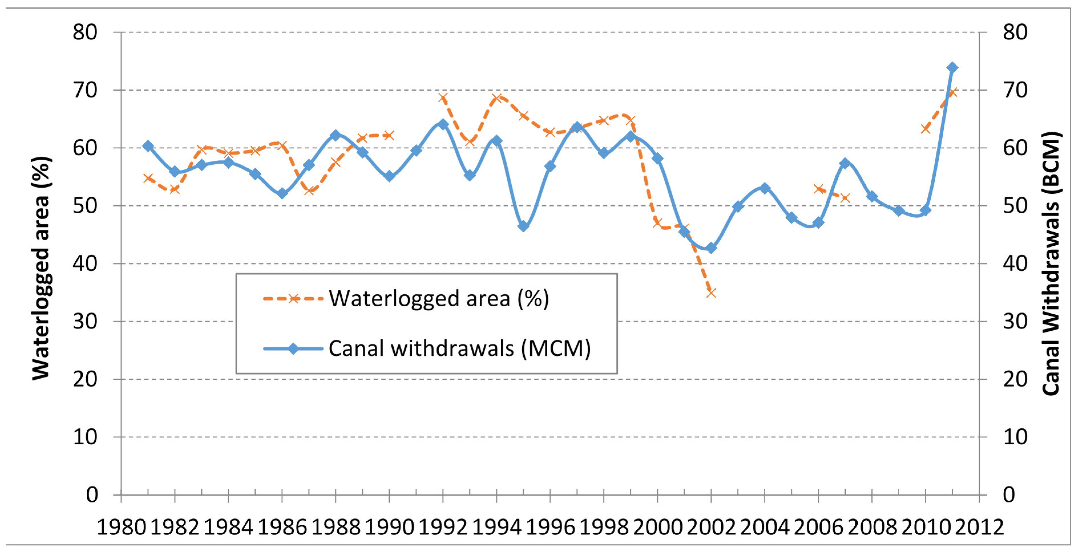
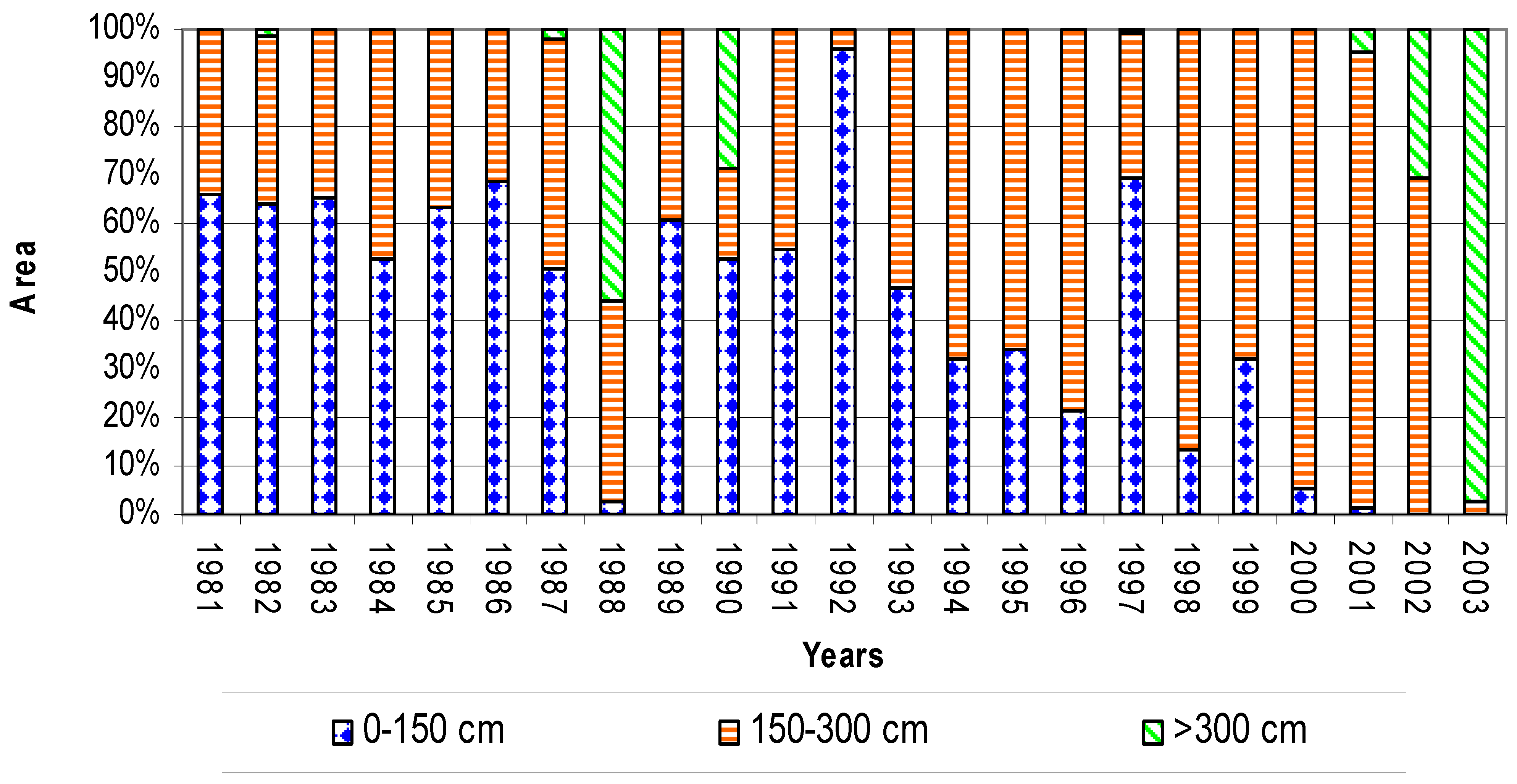
The waterlogged area in fact fluctuates enormously from year to year (
Figure 8). This is because of the reduction in the percentage of the waterlogged areas in the drought years due to the reduced inflows, the increased groundwater use and the more economical use of canal water by the farmers. Particularly, in low-lying areas with heavy soils, waterlogging and salinity disappeared (for instance in Badin and Mirpurkhas). The summary of
Figure 9 follows.
Waterlogged area increased from 62.14% in 1990 to 68.73% in 1992, responding to canal diversions of 55.12 BCM in 1990 to 64.08 in 1992.
Waterlogged areas dropped to 61.12% in 1993, as the surface water supplies reduced to 55.2 BCM.
Due to drastic reduction in available supplies in 2001 and 2002, the waterlogged area reduced to 45.48 and 34.98%, respectively; however, a part of this could also be attributed to the commissioning of the new drainage facilities under LBOD project.
Again in 2011, canal supplies and waterlogged areas increased; part of this waterlogging could also be attributed to excess rainfall and deterioration in performance of the drainage system, as pointed out by Basharat
et al. [
3].
Hence, there is a very strong case for reevaluating the surface water allocation in Sindh in normal years, because, at present, normal years bring huge increases in waterlogging and reduced crop production. Monitoring under the SCARP Transition Project showed no indication of groundwater-induced secondary salinization in Moro and Sakrand, but instead suggests that in recent years soil salinity has improved, due to increased private tubewell development and the leaching this made possible [
29]. This suggests that it is worthwhile to look into the option of draining saline water to create more storage for fresh water recharge.
In addition, there is an evident benefit to be gained from drainage facilities, provided they can be kept operational.
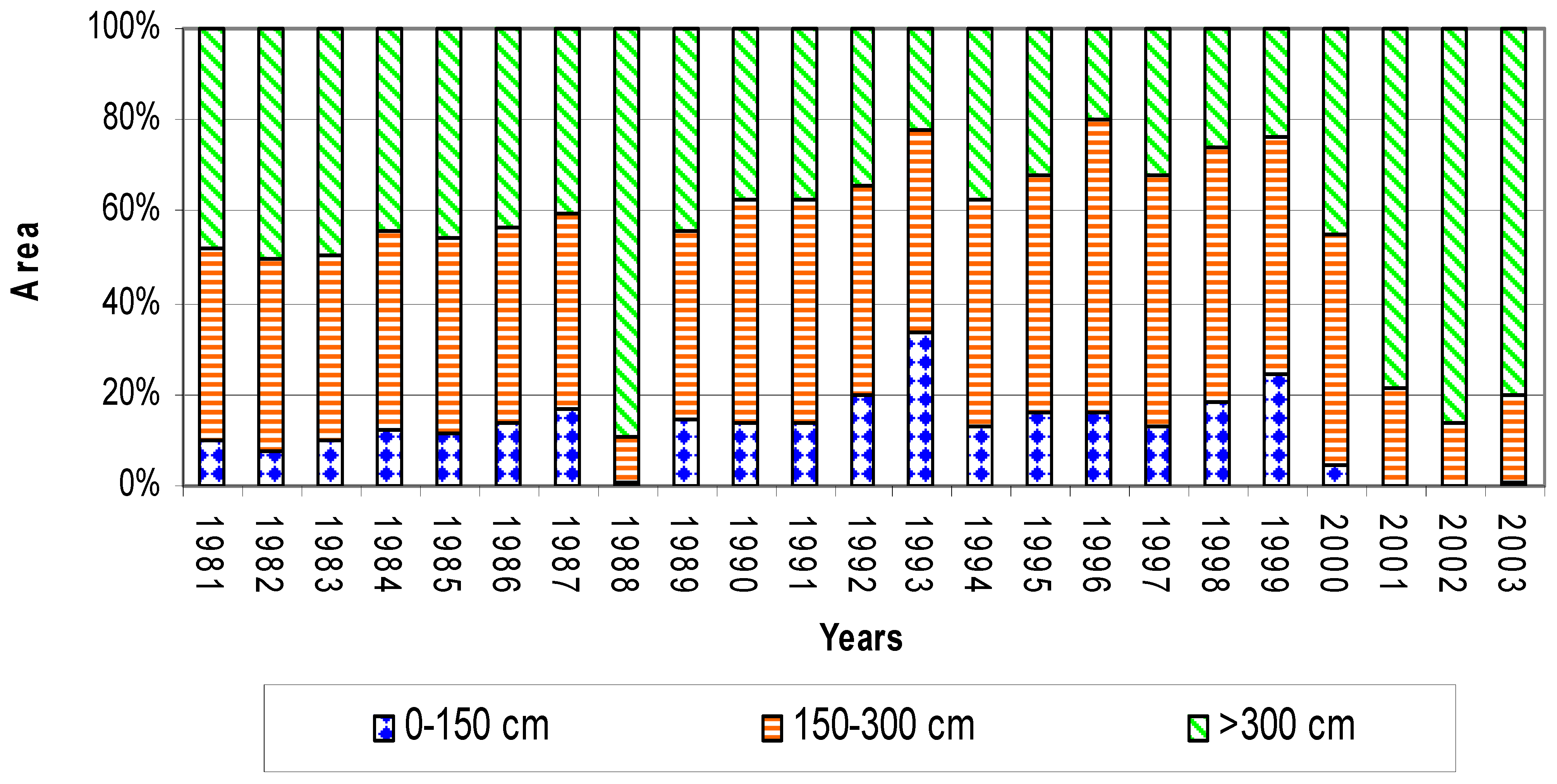
The same finding is repeated in a more detailed analysis of a number of canal commands and distributaries in Sindh.
Figure 9 and
Figure 10 show the reduction of pre-monsoon waterlogging for North West Canal and Rohri Canal.
Figure 8.
Waterlogging and canal supplies in Sindh (1980–2012).
Figure 8.
Waterlogging and canal supplies in Sindh (1980–2012).
Figure 9.
Pre-Monsoon Areas under Different Watertable Depths in North West Canal Command [
1].
Figure 9.
Pre-Monsoon Areas under Different Watertable Depths in North West Canal Command [
1].
Figure 10.
Pre-Monsoon Area under Different Water table Depths in Rohri Canal Command [
1].
Figure 10.
Pre-Monsoon Area under Different Water table Depths in Rohri Canal Command [
1].
A water management system with high waterlogging entails enormous water losses. For Sindh, 74%–80% of the available groundwater recharge is lost in the form of non-beneficial evaporation. These water losses, resulting from canal seepage and irrigation returns, could have been productively used as potential recharge. It occurs over both the fresh groundwater zones and saline groundwater zones of the province, in the ratio of 25:75 by area. Groundwater balance for the province, in broad terms and considering average rainfall and canal flows, is given in
Table 4 [
8].
The above figures indicate the order of magnitude. The budget shows colossal amounts of non-beneficial evapotranspiration of around 17 BCM, which can be saved partly by lowering water tables or reducing seepage from canals system and even canal supplies in certain areas and also by using groundwater of fresh-to-marginal quality through adjustment of the cropping pattern and introduction of fish ponds.
Table 4.
Groundwater balance for Sindh.
Table 4.
Groundwater balance for Sindh.
| Recharge/Discharge Components in BCM | Normal Year |
|---|
| Recharge Components | |
| Recharge from Rainfall | 2.42 |
| Recharge from Canal System @ 15% of 56 BCM | 8.34 |
| Return flow from Irrigation system @ 22.5% of net flow | 10.58 |
| Return flow from GW Abstraction @ 22.5% | 0.97 |
| Recharge from Rivers | 0.37 |
| Total | 22.68 |
| Discharge Components | |
| Groundwater Abstraction (Public + Private) | 4.30 |
| Non-beneficial ET losses | 16.96 |
| Base flow to rivers | 1.42 |
| Total | 22.68 |
6. Enabling Environment for Conjunctive Water Management
There is an urgent need for action to improve water productivity in Sindh in order to keep up with the increasing population and the need to better capture the opportunities in agricultural markets. Better conjunctive water management of surface water and groundwater will also improve drinking water availability, public health and the ability to store run-off from high rainfall events and hence prevent flooding.
Given the specific characteristics of Sindh, in particular the salinity of the groundwater (more so at greater depth), the flat gradient and the high surface water allocation, introducing conjunctive management would require six main interventions:
Rationalize irrigation duties;
Increase and intensify the irrigated areas;
Improve field water use efficiency;
Selective drainage investments;
Make use of storm water;
Adapt to saline conditions in some areas.
6.1. Rationalize Irrigation Duties
The first step is to properly manage the shallow groundwater resource and put an end to the widespread waterlogging by learning from the positive impacts of drought years (1999–2002). This should be done primarily by adjusting current canal supplies and irrigation duties and preparing area-specific conjunctive water management plans. At present, the irrigation duties amongst canal command are highly variable and defy prevailing water management logic. Some canals have extremely high duties (
Figure 5). The supplies to different areas become even further unbalanced, as significantly more water is diverted to certain areas than the designed discharges. An example is Ghotki Feeder, which already has high duties of 6.6 cusec per 1000 acres but on top of this receives as much as 30%–40% more supplies.
The result of these high duties is waterlogging and large volumes of non-beneficial evaporation, which reduces productivity, worsens public health and stands for the overall loss of water. In such high supply areas, canal tail end or higher lands at times have higher crop yields than the waterlogged head reaches. The irrigation duties should be set so as to develop an optimum balance between surface water supplies and groundwater availability, and usage and guidelines may be developed in support of this. This requires that:
- (a)
Surface water seepage is equivalent to groundwater use in combination with beneficial evaporation.
- (b)
Surface water supplies are set at an optimum scarcity so that they encourage groundwater pumping as a complementary source.
- (c)
Where groundwater is of marginal quality, the mixing of supplied surface water and pumped groundwater results in useable water quality.
In a number of areas, the supply of surface water may need to be curtailed, not only to encourage supplementary groundwater irrigation but to reduce the area that is waterlogged and cannot be used productively. The reduction of surface water supplies should go hand in hand with the introduction of water saving farming techniques (such as greenhouses, use of mulches, soil amendments (e.g., press mud), micro-irrigation and the introduction of other less water demanding crops). In other areas, surface supplies may be increased to have more recharge through canal seepage. This is particularly true for low-lying water-short areas in tail sections with fresh groundwater. Shifting excess water to such areas may achieve a higher level of balance in these areas, where the additional ground and surface water serve to support higher intensities—as in the lower section of Rohri Canal. In Rohri Canal, high water tables occur in patches due to seepage from the canal, the large number of direct outlets in places or blocked natural drainage, but in other areas water availability is low. Particularly in fresh groundwater areas, a reallocation of water from areas that are oversupplied would increase productivity by canal supplies and pumped groundwater.
To grow rice and sugarcane in the very flat lands of Sindh without adequate drainage results in waterlogging, with ill-effects on water productivity and public health. In areas with highly saline groundwater, the lowering of the water table will create space so that fresh water lenses can form on top of the saline water tables, fed by seepage and rainfall. This will at least make it possible to improve the availability of drinking water in such areas. This is what happened in the Drainage IV area where the drainage project made it possible for such fresh/brackish water lenses to develop and this was a major boost for local drinking water supply. If the fresh water lenses are thick enough, they can also be accessed for agriculture by dug wells or properly spaced skimming wells.
IWMI and Global Water Partnership [
30] have very rightly concluded that by considering groundwater availability and quality when allocating surface water, water managers could improve the equity, sustainability and productivity of irrigated systems. In areas with fresh or marginal groundwater, the canal supplies should be adjusted in such a way that a balance is achieved between using surface water and groundwater. Surface water supplies from canals need to ensure the right mixes of water qualities and to have water left for recharge. Canal supplies should be lowered so as to encourage groundwater pumping, especially in areas with fresh groundwater. The use of groundwater also makes it possible to have more precise agriculture and leads to much higher water productivity by providing a psychological cushion for the farmers for water use as and when required.
The management of the surface water in conjunction with groundwater requires political courage and leadership to take this on, as well as water balance models for the different canal commands to study its sustainability. A broad agenda for the six main commands in Lower Indus is given in
Table 5.
Table 5.
Agenda for the six main commands in Sindh.
Table 5.
Agenda for the six main commands in Sindh.
| Area | Water Management Priorities | Investment Priorities | Agricultural Priorities |
|---|
| Guddu Right Command | Rationalize irrigation duties | Restore surface drainage | Introduce more efficient rice irrigation |
| Guddu Left Command | Rationalize irrigation duties | Restore surface drainage | Use fresh water zones for high value crops |
| Sukkur Right Command | Rationalize irrigation duties for improved filed irrigation | Restore surface drainage | Introduce more efficient rice irrigation |
| Sukkur Left Command | Relocate/ increase supplies especially to fresh groundwater areas | Selective rehabilitation of saline drainage wells, escapes structures, lining of drainage section that are in fill | – |
| Kotri Right Command | – | Restore surface drainage | Reconsider cropping pattern to low delta crops |
| Kotri Left Command | Rationalize irrigation duties | Flap gates at tail of drains to prevent sea water intrusion and selected drainage investments | Reconsider cropping pattern to low delta crops. Introduce biosaline agriculture and aquaculture Introduce more efficient rice irrigation |
6.2. Increase and Intensify the Irrigated Areas
This leads to the second agenda item: the better buffer management in the canal command areas by revisiting the irrigation duties will save enough water within the provincial quota to consider developing/expanding the command areas and even developing new canals in Sindh (4.3 Mha of Thar has no access to surface water). There are areas where expansion is possible on either bank—preferably the areas chosen must have relatively fresh or marginal quality groundwater and relatively sandy soils, so that highly conjunctive systems can be developed right from the start. Going by the experience of the drought period, it may be possible to develop an additional area of 500,000 ha. At present, some of these expansions are already happening in an uncontrolled manner, with water in drains being fresh due to the large excess flows, which leads to its pumping by farmers. In reassessing the irrigation duties, the current reuse from drain may need to be considered and regularized.
Moreover, better use of shallow groundwater will also make it possible to intensify and extend the cropped areas through more groundwater irrigation by:
The promotion of shallow irrigation wells in general.
Promoting and regulating the collection and reuse of drainage water and creating special buffers in some areas that have heavy soils.
Particularly in the part of the province where fresh water overlays saline water, there is a need to carefully promote multi-strainer skimming wells that exploit water at a very shallow depth. In several such areas, groundwater is exploited by conventional tube wells and local up-coning of saline water is a tangible risk. There is a need for better guidance on the sustainable use of groundwater and the benefits of skimming wells. Combined with a rationalization of surface irrigation supplies, this can create a safe and productive way of exploiting thin fresh water buffers in the areas with shallow fresh groundwater and deeper saline groundwater. Presently, the occurrence of skimming wells is sparse. In some areas, they are common and even jointly owned, but in other areas they are relatively unknown. Their popularity in some areas is related to the fact that simpler drilling technology could be used for low depth low diameter multiple strainers, i.e., the same technology that is used for hand pumps.
Some crops with high water demands, such as sugarcane, are grown in areas such as the sandy riverine tract, primarily by using groundwater. Therefore, the financial feasibility of this type of agriculture is proven. However, costs of pumping may further be reduced by the application of water saving measures (see the next section), the introduction of fuel saving measures on the pump sets and the application of solar or wind energy.
6.3. Improve Field Water Use Efficiency
In close relation to that discussed in the previous section, it is important to look at field water management practices too. An improvement in the agriculture system is needed, particularly in the rice–wheat system in Sindh. Methodologies such as precise land leveling and mechanized operation have shown a boost in agriculture production and water saving of up to 50%. Direct seeding, the introduction of the System of Rice Intensification or other methods of alternate drying and wetting and growing rice in areas with saline groundwater, have the potential of saving water and increasing yields at the same time. In general, the rice–wheat system has much room for improvement [
27]: a large effort in ensuring equitable and reliable supplies (so as to avoid excessive water being monopolized in certain areas at the cost of reliable supplies elsewhere); restoration of the main irrigation systems and learning from the programs currently being implemented; the introduction of alternate drying and wetting, at least after panicle initiation; better irrigation scheduling; direct seeding; and the development of better field bunds so as to retain and control water better at standing depth.
There are several other examples of farmers applying water saving techniques and achieving high yield as well as avoiding the waterlogging that is all-pervasive in the land around them. Some examples are the systematic use of mulch (from banana or mango leaves) that reduces evaporation and increases the organic matter in the soil, the application of press mud from sugar mills and the use of low cost greenhouses.
Furthermore, the wasteful “pancho” system, whereby standing water in rice fields is drained before applying fresh water, and rice, more or less, grows in flowing water (as is practiced in the rice growing areas), would need to be discontinued. This will require investment in constructing additional field channels, so that each field can be served separately, as well as investment in drainage for low-lying areas.
6.4. Selective Drainage Investment
The fourth point is the need for a well-targeted initiative for a selective drainage investment program. The high non-functionality of all drainage systems (70%–90%), including the recently constructed Left Bank Outfall Drain (LBOD), gives a clear message to be very judicious in drainage investment. Moreover, the experience from LBOD also showed that due to the uncertainties in establishing the drainage coefficient in some areas, “too much” drainage facilities were foreseen and even before all facilities were operational, the system was in balance again. It is important to make a clear distinction between drainage for storm water removal (only surface drains) and root zone drainage (tube wells, tile drainage and surface drains).
There are a number of guiding principles for storm water drainage:
Priority should be given to unblocking surface drains closed by roads and railway tracks and making adequate cross drainage on new and old infrastructure compulsory.
In some cases, local dugouts may serve to lower groundwater tables, and also as local freshwater storage—such as borrow pits from construction.
Care should be taken not to “over drain” and make sure that water tables are lowered but not too much, so that the beneficial effects on soil moisture from water tables are safeguarded.
Additionally, in root zone drainage:
The main aim is to create enough storage space in the upper soil layers to ensure adequate soil aeration for crop growth and ideally, in saline areas, to allow the development of fresh water lenses that can be used for local drinking water systems. In addition, this root zone aeration would help to avoid rainfall flooding, as was observed in 2011 on left bank areas.
There is no reason at all to develop or maintain public drainage facilities in fresh groundwater zones, as normally most of the drainage requirement would be taken care of by private pumping in such areas. Such private pumping may be further stimulated by curtailing and rationalization of surface supplies, as described above.
Ideally, where root zone drainage is provided, there should be the possibility of flexibility in water levels and non-uniformity: some crops (rice) can tolerate high water tables, while for other crops, sub-irrigation is beneficial. It is better to have a controlled drainage system that accommodates the different requirements.
There should be constructive cooperation between farmers and government. By now, there are several examples of farmers maintaining and even investing in drainage facilities. Joint agreement and support in the provision of sophisticated Operation and Maintenance (O&M) is permanently needed.
Finally, biological drainage—in particular, the promotion of eucalyptus tree stands—needs to be more systematically promoted. At present, farmers often do not replant their eucalyptus trees because of the effect of the trees and leaves on the soil fertility. This requires the introduction of other eucalyptus varieties and the promotion of local concentrated eucalyptus forests rather than isolated stands.
The current generation of water professionals has the large responsibility to do better. In general, the response to waterlogging and salinity in Sindh has not been to prevent the problems and use the excessive water supplies into a potential level of production as argued above, but to respond to the problems by investment in watercourse lining or drainage investments. Investment in drainage, however, is the measure of last resort targeted at the areas that most need it. Where possible, the problem should be prevented by better managing surface supplies, which is the cheapest solution. In addition, there is an urgent need to restore natural drainage paths that are now often blocked by road and railway development or urban expansion.
6.5. Make Use of Storm Water
A fifth related agenda item in an overhauled water system is to turn the menace of floods into an opportunity and overhaul the storm water drainage system in order to create overflow areas in the dry regions. These areas should be chosen in such a way that the floods that are spread and infiltrated can be used to build up soil fertility and recharge shallow groundwater. This will further increase the agricultural potential of Sindh. In addition, a lowered groundwater table will help to better absorb flood events when they arrive. Some use of excess water is already made by some of the farmers in the tail areas by constructing small multifunctional storage ponds, which are also used by herdsmen and their livestock.
6.6. Adapt to Saline Conditions in Some Areas
Finally, a larger effort should be made to adapt to the saline conditions that are natural in Sindh, both the extensive occurrence of saline groundwater (in 70% of the land) as well as the soil salinity (affecting 20% of the land). There are several strategies that can help to adapt to salinity. An important one is the introduction of bio-saline agriculture and brackish pond fisheries. Bio-saline agriculture can make use of salt-tolerant halophytes and special varieties [
31], such as sesbania, that can yield high biomass fodder at 7.5 t/ha.
In addition, recent research indicates that even existing varieties of common crops (wheat, sorghum, sugar-beet, potatoes, etc.) can, after selection, adapt surprisingly well to the use of brackish water, particularly on free draining soils. In fact, a number of farmers are using locally selected wheat varieties. Other promising adaptation measures concern crop agronomy—from planting on ridges to using special salt-tolerant microbial agents.
To start this process, it is important to have an up to date understanding of groundwater quality at shallow and deeper depth, soil conditions, shallow stratigraphy and water levels. All these factors will contribute to the optimum conjunctive water use model for the concerned part of the command areas. The monitoring of water tables and groundwater quality needs to be fully resumed and extended to non-SCARP areas. The changes in water management require considerable discussion with farmers and rural leaders, but as this is more or less a win-win situation, it seems to be possible. There is also a need for action and study in a number of areas such as:
assessment of optimum water duties for different command areas and sections thereof, with the highest value cropping patterns;
developing local water buffering and water storage strategies;
promotion and improvement of techniques such as skimming wells and biological drainage;
addressing the issue of bringing down pollution in the drains, particularly from sugar mills; and
explore the precise scope of saline agriculture in the coastal areas.
Moreover, there is a need to get the process going at practical levels as well, with pilot activities at the level of minors and distributaries in different parts of the province. In a world of increased demand for agricultural products, Sindh has much potential to develop into an important source area. Situated close to good shipping lines in a region with impressive economic growth, Sindh cannot afford to deny itself the ample conjunctive opportunities within its own land and water resource system.
7. Conclusions and Recommendations
Keeping in view the increasing water demands and varying groundwater depth and quality in irrigated areas, the conjunctive use of surface and subsurface reservoirs needs to be pursued systematically in the Lower Indus. Basharat
et al. [
5] has highlighted a similar requirement for well-planned and integrated management approach in Punjab, stressing upon canal water reallocation amongst different canal commands.
There is a need to rethink and consider the introduction of conjunctive management of surface and groundwater in Sindh for a number of reasons:
It can reduce waterlogging and hence contribute to higher yields and better public health.
It can improve drinking water conditions, especially in areas with high saline groundwater tables, by creating the space for fresh water lenses.
It will improve sanitary conditions, as an unsaturated zone above the water table is maintained, which would prevent the sewerage to be in direct contact with the shallow groundwater being used by rural population.
It will make high value precision agriculture possible and introduce “on demand” irrigation within the canal systems, as farmers would be able to irrigate as and when required.
It can free up canal water and make it possible to expand the area under cultivation or intensification in Sindh or to have water available for environmental flows.
It will be possible to store frequent floods, especially generated by rainfalls, by creating more storage space in the shallow aquifers.
Therefore, in order to efficiently meet the water requirements of all sectors,
i.e., agriculture, domestic and industrial, an
ab initio level of water re-allocations and efficient water management in consideration of groundwater quality and its safe yield in various areas is recommended, as discussed in detail in
Section 6. This would certainly provide relief from the prevailing water management issues to all water use sectors and stakeholders in the area.


